
|
收稿日期: 2017-06-28
基金项目: 十三五民用航天预研项目(编号:Y7K00100KJ)
第一作者简介: 黄祥志,1985年生,男,助理研究员,研究方向为空间信息、大数据与智能挖掘。E-mail:huangxz@radi.ac.cn
通信作者简介: 臧文乾,1984年生,男,助理研究员,研究方向为遥感图像处理技术。E-mail:zangwq@radi.ac.cn
中图分类号: TP701
文献标识码: A
|
摘要
多源遥感数据综合应用是遥感发展的必然趋势,统一的遥感数据空间尺度分级模型是多源数据集成与综合应用的基础。虽然已有多种空间尺度分级模型,但很多主流模型并非出于分尺度综合应用目的,缺乏客观的比较和评价。国家基本比例尺系统作为经过论证、中国应用面最广泛、接受度最高的一种尺度分级系统,是以应用为导向的遥感数据空间尺度分级模型的最优参照系。从不同视觉精度下国家基本比例尺对图像空间分辨率的需求出发,比较各空间尺度分级模型的层级分辨率与需求分辨率的匹配情况,包括OGC Well Known Scale Set的GlobalCRS84Pixel和GoogleMapsCompatible,以及NASA WorldWind、Google Map、百度地图、天地图等软件平台采用的层级格网系统,以及“五层十五级”遥感数据组织模型,通过对数据信息冗余度的分析,对各个模型进行了评价。结果表明,在高视觉精度应用需求下,“五层十五级”模型与基本比例尺精度要求具有较明显的匹配优势,其次为OGC GoogleMapsCompatible模型和天地图模型,其余模型平均数据冗余倍数在2倍左右;在低视觉精度应用需求下,“五层十五级”模型平均数据冗余度仍为最低,其次为Google Map模型,其余模型平均数据冗余倍数都在2倍以上。
关键词
空间尺度分级模型, 遥感图像空间分辨率, 国家基本比例尺, 多源遥感数据综合应用, 五层十五级
Abstract
The progress of Internet and remote sensing technologies has increased the amount of available remote sensing satellite resources. Thus, extraction ability of remote sensing information becomes increasingly strong, and social application need for such data becomes increasingly diverse. Comprehensive application of multi-source remote sensing data has become an inevitable trend. Given that remote sensing data are spatiotemporal data, their comprehensive application needs to be carried out in a certain spatial scale. A unified spatial scale set for remote sensing data is a basic requirement for the integration and comprehensive application of multi-source data. Many popular spatial scale sets are available, and each of them exhibits its own advantages and disadvantages. However, none of them is currently applied as a standard. The lack of a standard spatial scale set restricts the comprehensive application of multi-source remote sensing data. Thus, popular spatial scale sets should be evaluated to establish or optimize a reasonable spatial scale set as a standard. Information density depends on the amount of information in a unit area. Thus, the spatial resolution of remote sensing images is an effective way of expressing the information density of remote sensing data. Map scale refers to the ratio of the distance on the map to that on the field, which imposes strong information requirements. A large map scale requires high information density, which indicates high spatial resolution. High image spatial resolution is necessary to obtain considerable surface details from a large map scale. If the image spatial resolution is insufficiently high, then the map will present inferior quality or will even be unavailable for use. However, high image space resolution is not always ideal for a specific scale. Excessively high resolution data indicate redundant data, which require high computational cost and storage and network resource. All these factors may affect the data display. The national primary scale is a widely used mapping scale grading system and is a perfect reference system to evaluate an optimal spatial scale set for remote sensing data application. Apart from map scale, visual precision is also an important index that affects the spatial resolution requirements. Visual precision requirements to remote sensing image application involve two levels. One is high visual precision requirement, which is suitable for application types of quantitative calculation, scientific analysis, and human–computer interaction. The other is low visual precision requirement, which is suitable for remote sensing data exhibition in long distance, such as image displays in a large screen and a wall map. In this study, the spatial resolutions required by the national primary scale in two visual precision levels were analyzed. Then, the optimal spatial resolution scale of current popular spatial scale sets was built by matching the requirements. The popular spatial scale sets included OGC popular scale sets " GlobalCRS84Pixel” and " GoogleMapsCompatible”, the grid system of NASA WorldWind, Google Map, Baidu Map, Map World, and the " five-layer fifteen-level” remote sensing data organization model. Thereafter, the data redundancy rates of these popular spatial scale sets were calculated and compared from the optimal resolutions to the required spatial resolutions of the national primary scale in two visual precision levels. Results show that, compared with other popular spatial scale sets, the " five-layer fifteen-level” remote sensing data organization model best matches the requirements of the national primary scale. In particular, the model presents the lowest average redundancy rates in the two visual precision levels among others. Therefore, the " five-layer fifteen-level” remote sensing data organization model is a suitable standard spatial scale set for the multi-scale comprehensive application of multi-source remote sensing data.
Key words
spatial scale set, spatial resolution of remote sensing image, the national primary scale, comprehensive application of multi-sources remote sensing data, five-layer fifteen-levels
1 引 言
在航天遥感发展的起步阶段,遥感卫星资源稀缺、用户和应用较为单一,航天遥感应用系统主要采用“一星一系统”的模式构建,随着遥感技术和互联网技术的进步,遥感卫星资源越来越多,遥感信息提取能力越来越强,社会化应用需求越来越多样,使得多源遥感数据综合应用成为了必然趋势(顾行发 等,2016)。遥感数据是一种地理时空数据,需要在特定的空间尺度下实现时空信息的综合应用,因此,统一的遥感数据空间尺度分级模型是多源数据集成与综合应用的基础(王晋年 等,2013)。虽然已有多种空间尺度分级模型,但很多主流模型并非出于分尺度综合应用的目的,如一些模型是以提高数据可视化速度为初衷而设计,主要侧重影像金字塔缓存中高低尺度间的流畅过度和数据的快速定位,并未考虑多尺度综合应用的便捷性与合理性。为防止盲目选取,有必要对各空间尺度分级模型从遥感数据分尺度综合应用的角度进行比较评价。
信息密度取决于单位面积上的信息量,遥感图像空间分辨率是体现遥感数据信息密度的有效指标之一,地图比例尺是指图上距离与实地距离之比,从信息量角度可以看出无论空间分辨率还是比例尺均从本质上反映了对信息密度的要求,相同空间范围下更高空间分辨率、更大比例尺要求更高的信息密度,这也从信息量角度反映出不同尺度间的关系。为了保持地表细节的清晰度,比例尺越大要求影像的空间分辨率也就越高。对于特定比例尺制图或应用的遥感数据需求,若选用的遥感图像空间分辨率过高则存在信息和数据的冗余,造成资源的浪费和处理压力;若空间分辨率过低,则成图质量低,不能满足精度要求。
目前很多学者在影像空间分辨率与比例尺关系方面已开展不少研究,包括土地利用制图最小上图单元及最大成图比例尺与遥感卫星数据空间分辨率的关系(刘顺喜 等,2003),通过几何纠正精度误差分析计算遥感卫星数据适用比例尺的方法(潘家文 等,2005),以及通过人眼分辨率分析国内外主流卫星的最佳成图比例尺(刘洋 等,2012)等。这些学者提供了许多值得借鉴的分析方法,但是主要还是从应用需求或卫星最佳成图比例尺等方面进行研究,对统一空间分级尺度的评价和建设方面讨论较少。
国家基本比例尺系统作为经过论证、中国应用面最广泛、接受度最高的一种尺度分级系统,是以应用为导向的遥感数据空间尺度分级模型最优的参照体系(魏香琴 等,2012)。除了比例尺尺度外,视觉精度也是影响各层级分辨率的选择重要指标,在不同的视觉精度要求下,同一比例尺对遥感图像空间分辨率的精度要求也不同(刘顺喜 等,2003)。空间尺度的分级是对客观无级空间的采样和降维,从信息密度的角度分析,遥感数据应用尺度遵循着就高不就低的原则,但过高的空间分辨率尺度带来的则是数据信息的冗余问题。因此,本文以国家基本比例尺作为空间尺度分级参照,从信息冗余的角度,对目前国内外主流的遥感数据空间尺度分级模型进行分析和对比,从而评价各模型作为统一遥感数据空间尺度分级模型的合理性和优劣性。
2 遥感数据空间尺度分级模型
遥感数据空间尺度分级模型是以遥感图像空间分辨率为对象,针对遥感数据应用或组织的需求,对连续无级的空间尺度进行分级,从而建立一套完整的空间尺度体系。遥感数据空间尺度分级模型常见于地理空间编码、遥感数据规格化组织、网络地图发布、图像金字塔缓存等。
目前国内外主要的遥感数据空间尺度分级模型有以下几种,包括OGC Well Known Scale Set的GlobalCRS84Pixel和GoogleMapsCompatible(OGC,2010),以及WorldWind(NASA,2017)、Google Map(http://map.google.com/[2017-06-27])、百度地图(http://map.baidu.com/[2017-06-27])、天地图(MapWorld,2017)等软件平台采用的层级格网系统,以及“五层十五级”遥感数据尺度模型(王栋,2012)。各模型空间尺度分级分辨率设置如表1所示,为便于比较,以1 m尺度作为基准层级进行对齐,其中天地图的空间尺度分级与OGC GoogleMapsCompatible基本一致,除了OGC GlobalCRS84Pixel、Google Map、“五层十五级”等层级格网系统外,其余都是采用四叉树的分级方法。
表 1 国内外主要遥感数据空间尺度分级模型的层级空间分辨率设置
Table 1 The spatial resolutions in well-known spatial scale sets for remote sensing data
| /m | ||||||
| 五层十五级 | WorldWind | 百度地图 | Google Map | 天地图 | OGC GlobalCRS84Pixel | OGC GoogleMapsCompatible |
| 131072 | 156543.034 | |||||
| 65536 | 78271.52 | 240000 | 78271.517 | |||
| 32768 | 36000 | 39135.76 | 120000 | 39135.758 | ||
| 16384 | 17000 | 19567.88 | 60000 | 19567.879 | ||
| 7827.328 | 8192 | 9000 | 9783.94 | 40000 | 9783.940 | |
| 3913.664 | 4096 | 4000 | 4891.97 | 20000 | 4891.970 | |
| 1956.832 | 2048 | 2000 | 2445.98 | 10000 | 2445.985 | |
| 2500 | 978.416 | 1024 | 568 | 1222.99 | 4000 | 1222.992 |
| 1000 | 489.208 | 512 | 549 | 611.5 | 2000 | 611.496 |
| 500 | 244.604 | 256 | 278 | 305.75 | 1000 | 305.748 |
| 250 | 122.302 | 128 | 139 | 152.87 | 500 | 152.874 |
| 100 | 61.151 | 64 | 69 | 76.44 | 166 | 76.437 |
| 50 | 30.576 | 32 | 35 | 38.22 | 100 | 38.219 |
3 遥感图像空间分辨率与成图比例尺关系分析方法
3.1 遥感图像空间分辨率
遥感影像的空间分辨率是指每个像元所代表的地面实际范围的大小,即图像能够识别的地面上两目标的最小距离或地面物体所能分辨的最小单元,通常单位为m。遥感图像空间分辨率反映了图像记录空间信息的详细程度。通常标准遥感影像产品的遥感图像空间分辨率可以从产品定义或其元数据信息中获得,经过空间尺度分级模型规格化的遥感图像,其图像空间分辨率为模型中对应层级分辨率。
3.2 国家基本比例尺
地图比例尺是指图上距离与实地距离之比,一般用1∶M表示图上距离比实地距离缩小的程度。国家基本比例尺包括1∶500、1∶1000、1∶2000、1∶5000、1∶1万、1∶2.5万、1∶5万、1∶10万、1∶25万、1∶50万、1∶100万等11种地图比例尺。国家基本比例尺是中国标准的空间尺度系列,是中国各行业制作专题图的参考比例尺标准,因此也是对以应用为导向的遥感数据空间尺度分级模型评价的一种合适参照。
3.3 人眼视觉精度与遥感图像应用需求
人眼视觉分辨率是指人眼明视距离(25 cm)能分辨的空间两点之间的最短距离,依据有关研究结果,人眼能分辨的两点间的最小距离是0.1 mm,通常为0.25—0.3 mm(骆继花 等, 2015)。
特定比例尺的制图需要满足比例尺精度的要求。比例尺精度就是比例尺的大小所反映的地图详尽程度。通常将地图上人眼视觉分辨率所代表的实地水平距离称为比例尺精度。则比例尺精度可以定义为
| $A=L/(1/M)=L \cdot M$ | (1) |
式中,A为比例尺精度,1/M为比例尺,L为人眼的视觉分辨率。
遥感图像应用相关的视觉精度需求,通常可以分为两类,即高视觉精度应用要求和低视觉精度应用要求。高视觉精度要求适用于遥感数据的定量计算、科学分析、人机交互等应用类型。低视觉精度要求的遥感数据应用主要为遥感图像的远距离可视化应用,如挂图展示、大屏幕可视化等。
考虑到定量计算和科学分析的精度需求,以及满足最广大人群的视觉精度需求,本文人眼视觉分辨率取上限值0.1 mm。因此,在分析高视觉精度要求的应用分辨率需求时,人眼视觉分辨率L=0.1 mm。低视觉精度要求主要适用于遥感图像的远距离可视化应用,因此,在分析低视觉精度要求的应用分辨率需求时,采用按1.5 m视距换算人眼明视距离(25 cm)时的人眼视觉分辨率进行分析,即L=0.6 mm。
3.4 遥感图像空间分辨率与成图比例尺关系
遥感图像空间分辨率与成图比例尺存在着一定关系,为了使遥感图像成图时能达到特定地图比例尺精度,遥感图像空间分辨率应不低于成图比例尺的精度要求,但过高的遥感图像空间分辨率将会带来数据信息的冗余,对计算、存储、网络及可视化造成压力,还可能影响图像显示效果需要额外重采样处理。因此,在不考虑遥感图像质量等自身因素的情况下,遥感图像空间分辨率应不低于成图比例尺精度要求,且与成图比例尺精度要求的数据冗余度越低制图效果越好。
| $R \leqslant A$ | (2) |
| $A=L \cdot M$ | (3) |
式中,R为遥感图像空间分辨率,A为比例尺精度要求,1/M为比例尺,L为人眼的视觉分辨率。
3.5 遥感数据空间尺度分级模型比较方法
为对比各空间尺度分级模型与基本比例尺需求的匹配关系,首先计算出11种国家基本比例尺在高视觉精度制图应用(L=0.1 mm)与低视觉精度制图应用(L=0.6 mm)时的比例尺精度要求。然后,按照式(2)与式(3)图像空间分辨率不低于比例尺精度要求且越接近越优的原则,查找并建立相应基本比例尺下各空间尺度分级模型中最匹配层级空间分辨率体系。再分别计算该分辨率与相应基本比例尺精度要求之间的数据冗余度,用以表示各空间尺度分级模型与基本比例尺精度需求之间存在的信息和数据冗余程度,从而比较各空间尺度分级模型在遥感数据空间尺度分级的合理度。
数据冗余度,即表示数据量的冗余倍数,其计算原理如式(4)—式(6),假设单位像素的数据量相同且图像面积相同,计算特定遥感图像空间分辨率与特定比例尺精度要求对应遥感图像像素量的比值。
| ${P_{\rm{i}}} \cdot {Q_{\rm{i}}}=S={P_{\rm{m}}} \cdot {Q_{\rm{m}}}$ | (4) |
| $P={R^2}$ | (5) |
| $C=\frac{{{Q_{\rm{i}}}}}{{{Q_{\rm{m}}}}}=\frac{{{P_{\rm{m}}}}}{{{P_{\rm{i}}}}}=\frac{{{R_{\rm{m}}}^2}}{{{R_{\rm{i}}}^2}}$ | (6) |
式中,C为数据冗余度,Qi为特定遥感图像空间分辨率下的图像像素量、Qm为特定比例尺精度要求下的图像像素量,P为单位像素面积、Pm为特定比例尺精度要求下的单位像素面积、Pi为特定遥感图像空间分辨率下的单位像素面积,S为图像面积,R为图像空间分辨率、Rm为特定比例尺精度要求对应的图像空间分辨率、Ri为特定遥感图像空间分辨率。
4 模型比较分析结果
4.1 不同视觉精度下的基本比例尺精度要求
针对11种国家基本比例尺,分别取人眼分辨率L=0.1 mm和L=0.6 mm计算各基本比例尺在高视觉精度与低视觉精度制图需求下的比例尺精度要求,根据式(3),计算结果如表2所示。
表 2 不同视觉精度下的基本比例尺精度要求
Table 2 The spatial resolution required by the national primary scale in two visual precision levels
| 基本比例尺 | L=0.1 mm时比例尺
精度要求/m |
L=0.6 mm时比例尺
精度要求/m |
| 1∶1000000 | 100 | 600 |
| 1∶500000 | 50 | 300 |
| 1∶250000 | 25 | 150 |
| 1∶100000 | 10 | 60 |
| 1∶50000 | 5 | 30 |
| 1∶25000 | 2.5 | 15 |
| 1∶10000 | 1 | 6 |
| 1∶5000 | 0.5 | 3 |
| 1∶2000 | 0.2 | 1.2 |
| 1∶1000 | 0.1 | 0.6 |
| 1∶500 | 0.05 | 0.3 |
4.2 相应基本比例尺下模型最匹配层级空间分辨率
根据各遥感数据空间尺度分级模型的层级空间分辨率设置(表1)和不同视觉精度下的基本比例尺精度要求(表2),经章节3.4所述原则方法查找,高视觉精度下基本比例尺对应各遥感数据空间尺度分级模型的最匹配层级空间分辨率如表3所示,低视觉精度下基本比例尺对应各遥感数据空间尺度分级模型的最匹配层级空间分辨率如表4所示,为使对比分析更全面,本文对各空间尺度分级模型按其规律进行了延展,以匹配大比例尺的空间分辨率需求。
表 3 高视觉精度下基本比例尺对应各遥感数据空间尺度分级模型的最匹配层级空间分辨率
Table 3 The optimal matched resolutions in well-known spatial scale sets for the national primary scale requirements in high visual precision level
| /m | |||||||
| 基本比例尺精度要求 | 五层十五级 | WorldWind | 百度地图 | Google Map | 天地图 | GlobalCRS84Pixel | GoogleMapsCompatible |
| 100 | 100 | 61.151 | 64 | 69 | 76.44 | 100 | 76.437 |
| 50 | 50 | 30.576 | 32 | 35 | 38.22 | 33 | 38.219 |
| 25 | 25 | 15.288 | 16 | 17 | 19.11 | 16 | 19.109 |
| 10 | 10 | 7.644 | 8 | 8 | 9.55 | 10 | 9.555 |
| 5 | 5 | 3.822 | 4 | 4 | 4.78 | 3 | 4.777 |
| 2.5 | 2.5 | 1.911 | 2 | 2.15 | 2.39 | 1 | 2.389 |
| 1 | 1 | 0.955 | 1 | 0.54 | 0.6 | 1 | 0.597 |
| 0.5 | 0.5 | 0.478 | 0.5 | 0.27 | 0.299 | 0.33 | 0.299 |
| 0.2 | 0.1 | 0.12 | 0.125 | 0.14 | 0.149 | 0.16 | 0.149 |
| 0.1 | 0.1 | 0.06 | 0.063 | 0.07 | 0.075 | 0.1 | 0.075 |
| 0.05 | 0.05 | 0.03 | 0.032 | 0.035 | 0.038 | 0.033 | 0.037 |
表 4 低视觉精度下基本比例尺对应各遥感数据空间尺度分级模型的最匹配层级空间分辨率
Table 4 The optimal matched resolutions in well-known spatial scale sets for the national primary scale requirements in low visual precision level
| /m | |||||||
| 基本比例尺精度要求 | 五层十五级 | WorldWind | 百度地图 | Google Map | 天地图 | GlobalCRS84Pixel | GoogleMapsCompatible |
| 600 | 500 | 489.208 | 512 | 568 | 305.75 | 500 | 305.748 |
| 300 | 250 | 244.604 | 256 | 278 | 152.87 | 166 | 152.874 |
| 150 | 100 | 122.302 | 128 | 139 | 76.44 | 100 | 76.437 |
| 60 | 50 | 30.576 | 32 | 35 | 38.22 | 33 | 38.219 |
| 30 | 25 | 15.288 | 16 | 17 | 19.11 | 16 | 19.109 |
| 15 | 10 | 7.644 | 8 | 8 | 9.55 | 10 | 9.555 |
| 6 | 5 | 3.822 | 4 | 4 | 4.78 | 3 | 4.777 |
| 3 | 2.5 | 1.911 | 2 | 2.15 | 2.39 | 3 | 2.389 |
| 1.2 | 1 | 0.955 | 1 | 1.07 | 1.19 | 1 | 1.194 |
| 0.6 | 0.5 | 0.478 | 0.5 | 0.54 | 0.6 | 0.33 | 0.597 |
| 0.3 | 0.25 | 0.239 | 0.25 | 0.27 | 0.299 | 0.16 | 0.299 |
4.3 相应基本比例尺下模型数据冗余度比较
根据基本比例尺精度要求(表2)和各遥感数据空间尺度分级模型相应基本比例尺在不同视觉精度下最匹配层级空间分辨率(表3、表4),经式(6)数据冗余度计算,结果如表5、表6所示,分别为高、低视觉精度下各遥感数据空间尺度分级模型最匹配层级空间分辨率相比基本比例尺精度要求的数据冗余度,其中着底色项为冗余度最低值。图1、图2分别为在高、低视觉精度下各遥感数据空间尺度分级模型相应的平均数据冗余度。
表 5 高视觉精度下对应基本比例尺要求各遥感数据空间尺度分级模型最匹配层级空间分辨率的数据冗余度
Table 5 The redundancy rate of each optimal matched resolutions in well-known spatial scale sets for the national primary scale requirements in high visual precision level
| /m | |||||||
| 基本比例尺 | 五层十五级 | WorldWind | 百度地图 | Google Map | 天地图 | GlobalCRS84Pixel | GoogleMapsCompatible |
| 1∶1000000 | 1.00 | 2.67 | 2.44 | 2.10 | 1.71 | 1.00 | 1.71 |
| 1∶500000 | 1.00 | 2.67 | 2.44 | 2.04 | 1.71 | 2.30 | 1.71 |
| 1∶250000 | 1.00 | 2.67 | 2.44 | 2.16 | 1.71 | 2.44 | 1.71 |
| 1∶100000 | 1.00 | 1.71 | 1.56 | 1.56 | 1.10 | 1.00 | 1.10 |
| 1∶50000 | 1.00 | 1.71 | 1.56 | 1.56 | 1.09 | 2.78 | 1.10 |
| 1∶25000 | 1.00 | 1.71 | 1.56 | 1.35 | 1.09 | 6.25 | 1.10 |
| 1∶10000 | 1.00 | 1.10 | 1.00 | 3.43 | 2.78 | 1.00 | 2.81 |
| 1∶5000 | 1.00 | 1.09 | 1.00 | 3.43 | 2.80 | 2.30 | 2.80 |
| 1∶2000 | 4.00 | 2.78 | 2.56 | 2.04 | 1.80 | 1.56 | 1.80 |
| 1∶1000 | 1.00 | 2.78 | 2.52 | 2.04 | 1.78 | 1.00 | 1.78 |
| 1∶500 | 1.00 | 2.78 | 2.44 | 2.04 | 1.73 | 2.30 | 1.83 |
| 注:阴影表示该层级的冗余度最低值。 | |||||||
表 6 低视觉精度下对应基本比例尺要求各遥感数据空间尺度分级模型最匹配层级空间分辨率的数据冗余度
Table 6 The redundancy rate of each optimal matched resolutions in well-known spatial scale sets for the national primary scale requirements in low visual precision level
| /m | |||||||
| 基本比例尺 | 五层十五级 | WorldWind | 百度地图 | Google Map | 天地图 | GlobalCRS84Pixel | GoogleMapsCompatible |
| 1∶1000000 | 1.44 | 1.50 | 1.37 | 1.12 | 3.85 | 1.44 | 3.85 |
| 1∶500000 | 1.44 | 1.50 | 1.37 | 1.16 | 3.85 | 3.27 | 3.85 |
| 1∶250000 | 2.25 | 1.50 | 1.37 | 1.16 | 3.85 | 2.25 | 3.85 |
| 1∶100000 | 1.44 | 3.85 | 3.52 | 2.94 | 2.46 | 3.31 | 2.46 |
| 1∶50000 | 1.44 | 3.85 | 3.52 | 3.11 | 2.46 | 3.52 | 2.46 |
| 1∶25000 | 2.25 | 3.85 | 3.52 | 3.52 | 2.47 | 2.25 | 2.46 |
| 1∶10000 | 1.44 | 2.46 | 2.25 | 2.25 | 1.58 | 4.00 | 1.58 |
| 1∶5000 | 1.44 | 2.46 | 2.25 | 1.95 | 1.58 | 1.00 | 1.58 |
| 1∶2000 | 1.44 | 1.58 | 1.44 | 1.26 | 1.02 | 1.44 | 1.02 |
| 1∶1000 | 1.44 | 1.58 | 1.44 | 1.23 | 1.01 | 3.31 | 1.01 |
| 1∶500 | 1.44 | 1.58 | 1.44 | 1.23 | 1.01 | 3.52 | 1.01 |
| 注:阴影表示该层级的冗余度最低值。 | |||||||


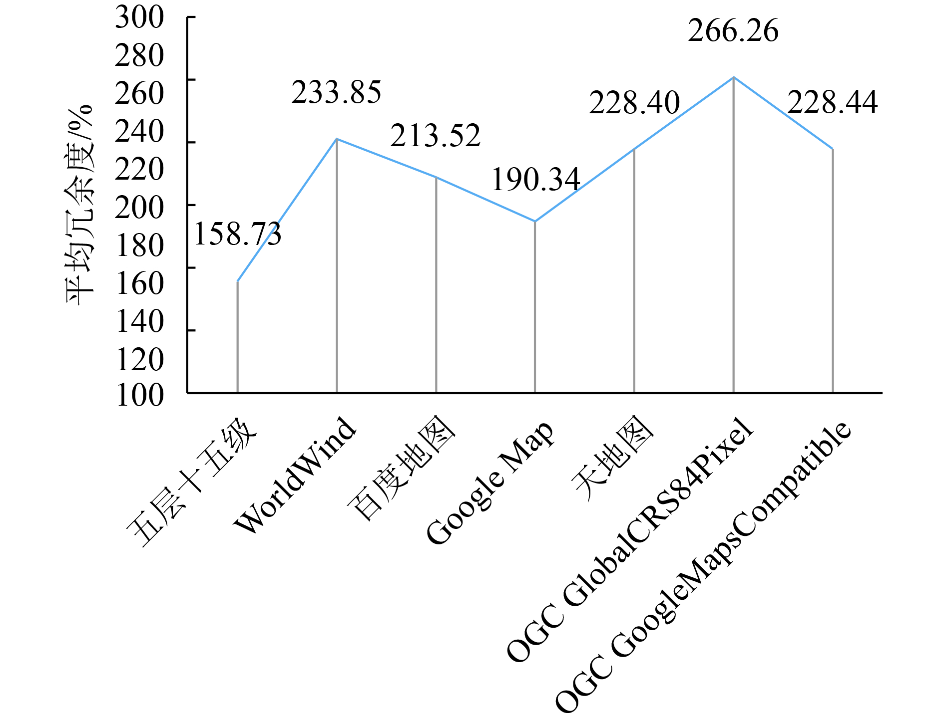
通过对结果数据的分析,在高视觉精度应用需求下:
(1) “五层十五级”模型相较其他模型具有最低的平均数据冗余度1.27倍,且在多数基本比例尺尺度上均为零冗余匹配,但在1∶2000尺度上存在较高冗余度。
(2) WorldWind模型的平均冗余度较高,达到2.15倍,特别是在1∶500—1∶2000尺度和1∶25万—1∶100万尺度上,相比其他模型冗余度最高。
(3) 百度地图模型平均冗余度为1.96倍,在1∶5000和1∶1万两个尺度上与基本比例尺达到零冗余匹配,但在1∶500—1∶2000尺度和1∶25万—1∶100万尺度上冗余度较高,整体冗余度情况与WorldWind模型相似,但略优于WorldWind模型。
(4) Google Map模型的平均冗余度较高,达到2.16倍,且在各个基本比例尺尺度上相较其他模型并不具备优势。
(5) OGC GoogleMapsCompatible模型和天地图模型的平均冗余度较低,为1.77倍,除了1∶5000和1∶1万两个尺度外,其他各尺度上的冗余度都低于2倍,整体上冗余度波动低,较为均衡。
(6) OGC GlobalCRS84Pixel模型在多个尺度上都具有最低的冗余度,在1∶1000、1∶1万、1∶10万、1∶100万等尺度上与基本比例尺达到零冗余匹配,在1∶2000尺度上冗余度优于其他所有模型,但是由于在个别尺度上冗余度波动较大,如在1∶2.5万尺度上冗余度达到了6.25倍,导致平均冗余度相较其他模型为最高,达到2.17倍。
在低视觉精度应用需求下:
(1) “五层十五级”模型的平均数据冗余度最低,为1.59倍,且在各尺度级别上的冗余度比较均衡,最大值2.25倍,最小值1.44倍,其中在1∶1万—1∶10万尺度上冗余度为各模型中最低。
(2) WorldWind模型的平均冗余度较高,达到2.34倍,特别是在1∶5000—1∶10万尺度上冗余度相对较高。
(3) 百度地图模型的平均冗余度为2.14倍,整体冗余度情况与WorldWind模型相似,在1∶5000—1∶10万尺度上冗余度偏高,但略优于WorldWind模型。
(4) Google Map模型的平均冗余度较低,为1.9倍,主要在小尺度或大尺度上较有优势,特别是在1∶25万—1∶100万尺度上冗余度相对最低,但在1∶5000—1∶10万尺度上冗余度相对较高。
(5) OGC GoogleMapsCompatible模型和天地图模型的平均冗余度为2.28倍,相较基本比例尺,该模型在大比例尺尺度上较有优势,其中在1∶500—1∶2000尺度上冗余度相对为最低,但在小比例尺尺度上冗余度相对为最高,不具备优势。
(6) OGC GlobalCRS84Pixel模型的平均冗余度最高,达到2.66倍,虽然在1∶5000和1∶2.5万两个尺度上相比其他模型冗余度最低,但其余各层级的冗余度较高,且各层级冗余度波动高,未形成尺度区间优势。
5 结 论
根据以上围绕遥感数据空间尺度分级模型与国家基本比例尺制图分辨率需求的比较分析结果,在OGC GlobalCRS84Pixel、OGC GoogleMapsCompatible、WorldWind、Google Map、百度地图、天地图、“五层十五级”等几种目前主流的遥感数据空间尺度分级模型中,在高视觉精度应用需求下,“五层十五级”模型与基本比例尺精度要求具有较明显的匹配优势,平均冗余度1.27倍,其次为OGC GoogleMapsCompatible模型和天地图模型,平均冗余度为1.77倍,其余模型平均数据冗余倍数都在2倍左右,其中OGC GlobalCRS84Pixel模型在多个尺度上都具有相对最低冗余度,但是由于在个别尺度上冗余度较高,整体冗余度波动较大,未形成尺度区间优势。在低视觉精度应用需求下,“五层十五级”模型平均数据冗余度1.59倍仍为最低,其次为Google Map模型1.9倍,其余模型平均数据冗余倍数都在2倍以上,其中OGC GoogleMapsCompatible模型和天地图模型在1∶500至1∶2000的尺度范围内冗余度较低,但在小比例尺尺度上冗余度相对为最高,不具备优势。
参考文献(References)
-
Gu X F, Yu T, Gao J, Tian G L, Wang C M, Zheng F J, Li J, Dong W, Mi X F, Hu X L, Xie Y, Meng Q Y, Liu Q Y, Yang J, Wei Z, Zhang Z W, Fang L, Lin Y H, Gao H L, Zhao L M, Zheng L J, Liu M, Li L L, Sun Y, Cheng Y, Zhang Y Z, Huang X Z, Zang W Q, Xu H, Wu Y, Liu P, Liu D H and Deng A J. 2016. Application-oriented scientific demonstration research for spaceborne remote sensing. Journal of Remote Sensing, 20 (5): 807–826. [DOI: 10.11834/jrs.20166209] ( 顾行发, 余涛, 高军, 田国良, 王春梅, 郑逢杰, 李娟, 董文, 米晓飞, 胡新礼, 谢勇, 孟庆岩, 刘其悦, 杨健, 卫征, 张周威, 方莉, 林英豪, 高海亮, 赵利民, 郑利娟, 刘苗, 李玲玲, 孙源, 程洋, 张雅洲, 黄祥志, 臧文乾, 徐辉, 吴俣, 柳鹏, 刘东晖, 邓安健. 2016. 面向应用的航天遥感科学论证研究. 遥感学报, 20 (5): 807–826. [DOI: 10.11834/jrs.20166209] )
-
Liu S X, You S C and Zhang D X. 2003. An analysis of the requirement for spatial resolution of chinese earth observation satellite after CBERS- 1 in land resource management. Remote Sensing for Land and Resources, 58 (4): 6–8. [DOI: 10.6046/gtzyyg.2003.04.02] ( 刘顺喜, 尤淑撑, 张定祥. 2003. 土地资源管理对我国后续资源卫星数据空间分辨率的需求分析. 国土资源遥感, 58 (4): 6–8. [DOI: 10.6046/gtzyyg.2003.04.02] )
-
Liu Y, Xin R and Sun X M. 2012. Applicability analysis of eye resolution, satellite resolution and mapping scale. Heilongjiang Agricultural Sciences (9): 126–129. [DOI: 10.3969/j.issn.1002-2767.2012.09.042] ( 刘洋, 辛蕊, 孙晓明. 2012. 人眼分辨率和卫星数据分辨率与成图比例尺的适用性分析. 黑龙江农业科技 (9): 126–129. [DOI: 10.3969/j.issn.1002-2767.2012.09.042] )
-
Lou J H, Wang H Y and Xie X Y. 2015. The discussion of the relation between map scale and remote sensing image resolution. Geomatics and Spatial Information Technology, 38 (12): 61–64, 71. [DOI: 10.3969/j.issn.1672-5867.2015.12.019] ( 骆继花, 王鸿燕, 谢志英. 2015. 地图比例尺与遥感影像分辨率的关系探讨. 测绘与空间地理信息, 38 (12): 61–64, 71. [DOI: 10.3969/j.issn.1672-5867.2015.12.019] )
-
MapWorld(天地图国家地理信息公共服务平台). (2017). http://www.tianditu.cn/ [2017-06-27]
-
NASA World Wind. (2017). https://worldwind.arc.nasa.gov/ [2017-06-27]
-
OGC. Open GIS Web Map TileService Implementation Standard. (2010). http://www.opengeospatial.org/standards/wmts [2017-06-27]
-
Pan J W, Zhu D H, Yan T L and Sun L. 2005. Application of the relationship between spatial resolution of RS image and mapping scale. Transactions of the CSAE, 21 (9): 124–128. [DOI: 10.3321/j.issn:1002-6819.2005.09.027] ( 潘家文, 朱德海, 严泰来, 孙丽. 2005. 遥感影像空间分辨率与成图比例尺的关系应用研究. 农业工程学报, 21 (9): 124–128. [DOI: 10.3321/j.issn:1002-6819.2005.09.027] )
-
Wang D, Zheng F B, Lai J B, Yu T, Li J G and Guo S. 2012. A new parallel algorithm based on Five-layer Fifteen-level Remote Sensing data organization. , 28 (1): 166–167. ( 王栋, 郑逢斌, 赖积保, 余涛, 李家国, 郭珊. 2012. 基于五层十五级遥感数据结构的并行算法研究. 微计算机信息, 28 (1): 166–167. )
-
Wang J N, Gu X F, Ming T and Zhou X. 2013. Classification and gradation rule for remote sensing satellite data products. Journal of Remote Sensing, 17 (3): 566–577. [DOI: 10.11834/jrs.20131364] ( 王晋年, 顾行发, 明涛, 周翔. 2013. 遥感卫星数据产品分类分级规则研究. 遥感学报, 17 (3): 566–577. [DOI: 10.11834/jrs.20131364] )
-
Wei X Q, Gu X F, Yu T, Meng Q Y, Li B and Guo H. 2012. Spatial resolution standardization of payload on board of remote sensing satellite based on application requirements. Spectroscopy and Spectral Analysi, 32 (3): 781–785. [DOI: 10.3964/j.issn.1000-0593(2012)03-0781-05] ( 魏香琴, 顾行发, 余涛, 孟庆岩, 李斌, 郭红. 2012. 面向应用需求的遥感卫星载荷空间分辨率标准化研究. 光谱学与光谱分析, 32 (3): 781–785. [DOI: 10.3964/j.issn.1000-0593(2012)03-0781-05] )


