
|
收稿日期: 2016-05-16; 修改日期: 2017-01-17; 优先数字出版日期: 2017-01-24
基金项目: 国家自然科学基金(编号:41401432)
第一作者简介: 李少英(1987— ),女,副教授,研究方向为遥感与地理信息系统应用、多智能体模拟。E-mail:
lsy_0130@163.com
通讯作者简介: 刘小平(1978— ),男,教授,研究方向为地理模拟空间智能及优化决策。E-mail:
liuxp3@mail.sysu.edu.cn
中图分类号: TP79
文献标识码: A
|
摘要
元胞自动机CA(Cellular Automata)和多智能体ABM(Agent-Based Model)模型是土地利用格局和演化模拟的主流方法,两者在模拟自然因素影响和人文驱动机制方面具有突出优势,为LUCC研究提供了重要的工具。当前,ABM无论在模型构建还是应用研究方面,CA和ABM均取得了显著进展。论文从数据基础、模拟尺度、CA转换规则挖掘、ABM行为规则定义、CA和ABM的耦合4个方面梳理土地利用模拟模型和方法的研究进展。并总结这些模型在虚拟城市模拟与理论验证、真实城市模拟与规划预测以及多类用地模拟与辅助决策等方面的应用。最后,总结土地利用模拟模型在精细模拟和全球变化研究方面存在的局限性,认为未来发展将主要集中于解决从2维模型向3维模型发展、大数据与规则精细挖掘以及大尺度模拟与知识迁移等问题。
关键词
土地利用/土地覆盖变化, 过程建模与模拟, 元胞自动机, 多智能体系统, 尺度
Abstract
Land Use and Land Cover change (LUCC) is a main research subject of global environmental change and sustainable development. LUCC is a complex and dynamic process that involves both natural and human systems. Land use simulation models are powerful tools for understanding the driving forces of LUCC, for supporting urban planning and decision making, and for providing important information to evaluate the ecosystem effects of LUCC. Land use dynamic systems are difficult to predict through traditional " top–down” models. The Cellular Automata (CA) model and Agent-Based Model (ABM) are " bottom–up” approaches that have attracted increasing attention as powerful modeling tools in simulating land use patterns and evolution processes. In a CA model, each cell has a finite number of states, which can represent land use or land cover types. Changes in individual cells are defined by transition rules and generate the macro pattern of land use changes. The CA model has outstanding advantages in simulating the natural driving factors of land use dynamics. However, the influences of human factors are difficult to represent in a CA model. ABM, by contrast, can reflect the decisions and behaviors of individuals, such as government, investors, and residents. In an ABM, agents can move and interact with each other and with the environment. These local interactions generate certain land use patterns on the global scale. Thus, the two models have distinct advantages in modeling land use dynamics. Currently, the development of the CA and ABM models has achieved several important breakthroughs. This paper summarizes the recent progress in land use simulation models from the perspective of theory and methodology, including scale sensitivity, CA transition and ABM behavior rules, and coupled CA and ABM models. This paper also outlines the applications of these models in virtual city simulation and theoretical verification, realistic city simulation and scenario prediction, multitype land use and cover simulation, and decision support. However, the current land use models have obvious limitations on some crucial issues, such as fine and large-scale simulation. Hence, this paper discusses these problems and proposes the inclusion of three-dimensional modeling, big data, and rule-mining for fine simulation, as well as large-scale simulation and knowledge transfer, in future studies.
Key words
Land Use/Land Cover change, progress modelling and simulation, Cellular Automata (CA), multi-agent system (ABM), scale
1 引 言
土地利用/土地覆盖变化LUCC(Land Use and Land Cover Change)是影响生态环境的重要因素,成为了全球变化和可持续发展研究的热点问题(Bathrellos 等,2008;田光进和邬建国,2008;Samat 等,2011)。LUCC是一个受自然和人文因素驱动的动态过程,其过程和机理非常复杂(Xu 等,2015)。土地利用过程建模与模拟则成为研究LUCC的主要途径之一,它是探讨土地利用驱动机制、支持城市规划与政策制定以及评估土地利用对生态环境影响的重要工具(Li和Yeh,2000;He 等,2008;Kuang,2011)。
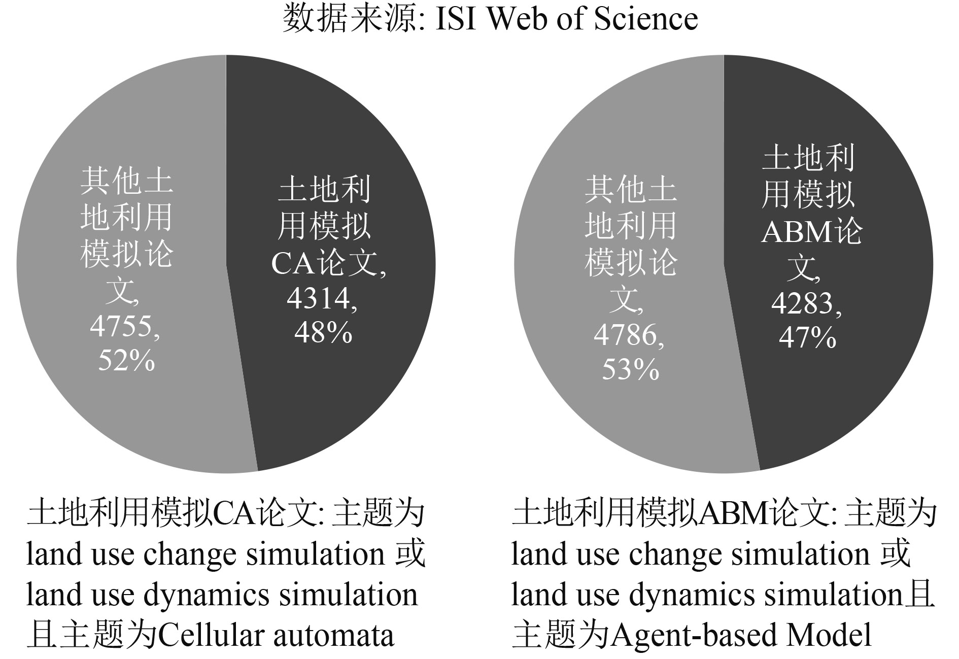
元胞自动机CA (Cellular Automata)模型和多智能体ABM (Agent-Based Model)模型这两种“自下而上”的建模方法因其具有强大的时空建模能力,成为了当前国际上土地利用模拟的主流模型(黎夏 等,2007;van Vilet 等,2012),国际相关研究的统计数据如图1所示。CA模型能够通过局部简单的规则改变元胞状态,从而产生宏观的土地利用变化结果;ABM模型可以通过微观智能体Agent交互作用模拟土地利用变化。CA模型侧重自然环境因素的影响,ABM模型则着重考虑空间决策行为与人文驱动因素的表达(Li和Liu,2007)。这两者各具独特优势,是探索和分析土地利用格局的形成、演变过程及其驱动机制的重要工具。CA和ABM模型的发展极大地丰富了LUCC的建模方法。

当前,CA和ABM两种建模方法在土地利用模拟的理论方法研究和实践应用方面均取得了重要的进展。本文试图从数据基础、模拟尺度、CA转换规则挖掘与参数校准、ABM异质属性与行为规则定义、CA与ABM耦合等核心问题出发,总结土地利用模拟模型和方法的研究进展。并从虚拟城市模拟与理论验证、真实城市模拟与规划情景预测、多类土地利用模拟与辅助决策等方向阐述CA和ABM模型在土地利用应用领域所发挥的重要作用。最后,提出土地用模拟模型发展存在的难点和面临的挑战,讨论土地利用模拟的重要发展方向,为未来土地利用精细模拟与精准决策研究提供新的思路。
2 土地利用模拟主要模型
2.1 CA模型
CA模型基于“自下而上”的建模思路,具有强大的空间运算能力,常用于自组织系统演变过程的研究(周成虎 等,1999)。CA模型主要由空间、元胞、邻域和转化规则4个要素组成(White 等,1997)。在传统的土地利用CA模型中,时间被认为是离散的,而空间是由2维栅格空间组成,每个元胞的状态代表土地利用类型;通过邻域状态和转化规则确定元胞转化为其他土地利用类型的概率。CA模型充分体现了复杂系统局部的个体行为产生全局、有秩序模式的理念(Wu和Webster,1998)。CA模型在模拟土地利用系统时具有以下的突出优势(Li和Yeh,2002b;黎夏 等,2007):(1) CA模型通过简单的局部转换规则可以模拟出复杂的土地利用格局;(2) CA为土地利用复杂系统的演化提供了很好的过程分析能力;(3) CA模型能与Geographic Information System(GIS)和Remote Sensing(RS)数据很好地耦合,极大地提高现有GIS分析复杂自然现象的能力和时空动态建模的功能。
2.2 ABM模型
在CA模型中,元胞的位置不能移动,只能改变其状态(黎夏 等,2010)。因此,CA模型在城市模拟过程中侧重的是自然环境要素,无法考虑土地利用变化过程中的人文因素影响,如政府、开发商、居民等(Li和Liu,2007)。与CA不同的是,ABM模型能够表达可移动Agent个体的行为规则,能够弥补CA个体行为模拟能力的不足(Macal和North,2010)。ABM是由多个相互交互的智能体Agent组成的,Agent具有动态的行为和异质性特征(Heckbert 等,2010)。在模型中,Agent之间及其与周围环境进行相互作用、相互影响、相互学习,不断调整自身行为和决策来适应环境。土地用动态变化过程是基于微观空间个体之间、个体与环境之间相互作用的结果(黎夏 等,2007)。ABM可以通过微观智能体之间及其与地理空间环境相互作用模拟,模拟土地利用变化过程中复杂空间决策行为与人文因素(van Vilet 等,2012)。与CA模型相比,ABM模型更能反映复杂的人地关系,在土地利用模拟中逐渐得到了应用。
3 土地利用模拟的核心问题
3.1 土地利用模拟的遥感数据获取
CA和ABM模型的输入数据以土地利用空间数据及其自然环境影响因子与社会经济影响因子数据为主。CA模型往往通过对土地利用变化及其驱动因子数据的训练获取元胞的转化规则。而在ABM模型中,土地利用及自然社会因子是智能体活动的空间载体,影响着智能体的行为决策。模型输入数据的获取对于土地利用模拟至关重要。
土地利用数据的遥感获取是模拟的核心。已有研究往往利用遥感分类或解译手段从遥感影像中获取土地利用历史变化空间信息。大多数城市或区域尺度上的模拟模型以分辨率为30 m的TM或ETM影像为数据源,通过影像分类获取土地利用变化信息(Li和Yeh,2000,2001,2004;Almeida 等,2008;He 等,2013;Xu 等,2015)。为提高运行效率,当研究区域较大时往往将输入数据进行重采样,转换为50 m、100 m等低变分辨率数据。而在某些小区域模拟中,为获得更高精度模拟结果,可能会通过高分辨率影像进行解译,获取精细土地利用数据。如在Wang和Marceau(2013)的研究中,采用SPOT 5影像,采用面向对象的遥感分类方法,提取建筑物、道路、森林、绿地、高尔夫球场、水体等精细土地利用信息。Blaschke等人(2014)提出了面向对象分类方法在高分辨率影像信息获取中的突出优势。Li等人(2016)对比了不同分类器在高分影像面向对象分类应用中的优缺点,Ma等人(2015)探讨了面向对象的无人机高分影像分类中训练集大小、尺度和特征等问题。这些研究可为精细土地利用获取提供重要的参考。
3.2 土地利用模拟的地理尺度
许多地理现象和地理过程存在明显的尺度依赖性。地理尺度是土地利用过程模拟的核心问题(Li和Li,2015),研究土地利用模拟的尺度效应对于帮助认识和理解不同尺度下土地利用格局、过程和机制具有重要的意义(Pan 等,2010)。
在空间幅度方面,已有土地利用模拟模型主要集中于县级尺度(Batty和Xie,1994;Liu 等,2013;周淑丽 等,2014)、市级尺度(White 等,1997;Ligtenberg 等,2001;Li和Yeh,2001,2002b;He 等,2008;Moghadam和Helbich,2013)和区域尺度(Clarke和Gaydos,1998;Jantz 等,2004;Li和Liu,2008;Kuang,2011;Samat 等,2011;He 等,2013)的模拟。大尺度的土地利用模拟存在数据量大、计算复杂、计算时间长等难点。为克服该问题,Li等人(2010)尝试将并行计算技术与CA模型结合起来,应用于珠江三角洲城市扩张模拟,提高了区域CA模拟的效率。Li等人(2012)尝试将GPU通用计算技术应用于广东省土地利用变化CA模拟中,比一般CA模型的运行效率提高了30倍以上。然而,开展大尺度的土地利用CA模拟还需解决不同地区土地利用演化机制差异的问题,如何有效挖掘差异化模型参数仍有待进一步研究。
在空间粒度方面,大部分土地利用CA模型是以栅格数据为基础,基于规则像元进行构建。而基于斑块为对象的CA模型相对罕见。研究表明,像元尺度上的CA模拟具有显著的尺度敏感性,模拟结果受像元大小、邻域结构和邻域形状等空间尺度要素的影响(柯新利 等,2010)。因此,最佳尺度的确定是基于像元的CA模拟需要解决的重要问题。Pan等人(2010)通过北京密云县模拟试验,确定模拟的最佳尺度为25 m的像元大小和9×9的摩尔邻域。然而,CA模拟的最佳尺度因不同研究问题和不同研究区域而存在差异。为避免栅格数据模拟的尺度敏感性,一些学者尝试利用矢量数据开展斑块尺度上的CA模拟(Moreno 等,2009;Wang和Marceau,2013;Chen 等,2014)。以斑块为基本分析单元进行模拟,能够更真实地表达城市地块空间实体及其属性。但是,像元场景下邻域相互作用机制将无法适用于以斑块为对象的模拟。如何更真实地在模型中表达地块对象的复杂内涵以及地块对象之间的空间联系是当前矢量CA模拟需要解决的重要科学问题。与CA模型类似,矢量ABM模型的提出可以克服传统栅格模型尺度敏感性大的弱点(Crooks,2010)。然而,现有矢量ABM模型尚未实现地块形状的不规则变化模拟,有待深入研究(周淑丽 等,2014)。
3.3 CA转换规则挖掘与参数校准
将CA应用于土地利用变化模拟时,需要解决包括如何把复杂的资源环境影响因素引进模型中、确定转化规则和参数等。针对不同的研究区域和研究对象,学者们提出了CA转换规则的各种获取方法,例如基于多准则判断MCE的方法(Wu和Webster,1998)和基于5个因子的SLEUTH模型(Clarke 等,1997;Clarke和Gaydos,1998)。MCE方法简单,容易实现,SLEUTH方法地理机制明确,容易解释地理成因,但是这两种方法的参数确定都带有一定的主观性和随机性。为了克服这个问题,一些学者提出了利用Logistic回归、神经网络ANN、主成分分析PCA、非线性核学习机、支持向量机等方法获取CA模型的转化规则和参数(Wu,2002;Li和Yeh,2002a,2002b;Liu 等,2008;Yang 等,2008)。Logistic回归方法获取CA模型参数方法简单实用,得到了较为广泛的应用,但线性模型难以反映土地用变化所涉及的非线性复杂特征。ANN-CA模型只需通过训练数据对神经网络进行训练,便可以自动获取模型参数,但ANN属于黑箱结构,也存在过学习、局部最小值和收敛速度慢等问题。PCA、非线性核学习机和支持向量机为解决复杂非线性问题提供了一个简单有效的方法,但难以解释空间变量对土地利用变化的驱动机制。当研究区域较复杂时,确定CA模型结构和参数时存在较大的困难。黎夏和刘小平等人随后又提出将一些最新发展的人工智能算法引进CA非线性转换规则获取中,利用数据挖掘、遗传算法、蚁群算法、人工免疫算法等人工智能方法对CA模型的转换规则进行智能获取与纠正,获得了较高的模拟精度与模拟效率(Li和Yeh,2004;Li和Liu,2006;Liu 等,2007,2010;Li 等,2007)。传统CA模型可以较好地模拟填充式和边缘式的城市扩张模式,但难以模拟跳跃式的城市扩张模式。Liu等人(2014)将景观扩张指数(Landscape expansion index)引入CA模拟中,在模拟不同城市增长模式中取得较好的效果。大多数模型在模拟过程中采用静态的模型参数,忽略了模型不确定性和误差的传递。针对该问题,张亦汉等(2013)提出了耦合遥感观测和CA的土地利用模拟模型,通过对遥感观测数据进行同化,动态地调整模型参数和纠正模拟结果。数量统计方法、人工智能方法的引入,在促进CA模拟参数获取与参数纠正智能化、提高土地利用模拟精度、减少模拟不确定性等方面做出了重要贡献。
3.4 ABM异质属性与行为规则定义
ABM模型的基本计算单元是Agent。Agent具有异质性特征,不同类型Agent具有不同的偏好、福利、期望、效用等属性,影响着Agent的行为决策,决定了Agent之间及其与环境之间的交互作用,最终形成土地利用动态结果(Irwin,2010;Crooks和Heppenstall,2012)。因此,Agent异质属性及其行为规则的定义以及模型参数获取是ABM模型构建的关键,会对土地利用模拟结果产生重要的影响(Chen 等,2012)。已有模型主要利用宏观统计数据或经验数据获取Agent的社会属性,而利用遥感和GIS方法计算Agent的位置属性。如在刘小平等(2006)的研究中,利用GIS方法获取了环境质量、公共设施、土地价格空间数据作为计算居民Agent位置属性的依据,基于统计年鉴和人口普通数据获取Agent收入和有无小孩等社会属性。有些ABM模型主要利用效用函数定义Agent的行为规则,如居民Agent利用效用最大化理论进行居住区位选择(Li和Liu,2007;刘小平 等,2010)。也有些模型利用经典经济理论或城市理论,对真实城市做出一些基本假设,从而定义Agent的行为及其与环境的交互作用。如Chen等人利用城市经济理论定义Agent的居住区位决策行为(Chen 等,2012)。Li等人(2013a)基于劳动经济学理论对劳动力市场供给和需求进行表达,进而定义个体在劳动力市场影响下的就业和居住选择行为。Agent行为规则定义时往往涉及多个影响因素,如何有效确定模型参数是许多ABM模型需要解决的重要问题。Li和Liu(2007)提出了利用MCE方法确定不同Agent影响因素的权重;Xu等人(2015)提出利用ACO方法对Agent行为决策目标进行优化。然而,在已有ABM模型中,个体属性和行为规则确定与真实城市描述仍然存在一定的距离。
3.5 CA模型与ABM模型的耦合
CA和ABM的结合将有助于反映土地利用动态演化过程中的自然与人文驱动因素,已在国内外土地利用模拟中得到了一些应用。Ligtenberg等人(2001)较早结合ABM和CA模型,建立了土地利用情景模拟模型;黎夏等人(2006)在国内率先提出了耦合CA和ABM的地理模拟系统理论框架,并将其应用于土地利用模拟与规划情景预测中;全泉等人(2011)结合CA和ABM对上海城市扩张动态过程进行模拟;Liu等人(2013)构建了CA-ABM模型对乡村用地向城镇用地转变过程进行模拟。在CA和ABM的耦合模型中,元胞用来表征不可移动的地理空间实体,如土地利用、自然因素等;多智能体用于模拟地理环境下可移动的决策主体,如政府、居民、开发商、农户等。CA和ABM恰好对应了人地关系中的两个基本要素—人类和自然环境,两者的结合可以有效地探索人地相互作用而导致的城市和区域土地利用结构演化过程。
4 土地利用模拟模型的应用
土地利用模拟模型主要应用于虚拟城市模拟与理论验证、真实城市模拟与规划预测以及多类用地模拟与决策支持。各个应用方向中CA和ABM模型的代表性研究及其主要贡献如表1所示。
表 1 土地利用模拟模型的应用方向及其代表性研究与主要贡献
Table 1 The application directions of land use simulation models and the main contribution of representative research
| 应用方向 | 模型分类 | 代表性文献 | 主要贡献 |
| 虚拟城市模拟与理论验证 | CA模型 | Couclelis(1985) | 证明了CA模型中,简单的局部规则能够产生复杂的宏观格局 |
| White和Engelen(1993) | 模拟了城市分形结构特征和城市演化过程 | ||
| ABM模型 | Schelling(1971) | 提出隔离模型,验证了城市系统“从混沌产生秩序”的复杂特性以及居住分异现象的形成 | |
| Benenson等(1998;2002) | 证明了经济、社会差异会导致居民空间分异现象 | ||
| 刘小平等(2010) | 提出ABMRL模型,验证了圈层结构和绅士化城市理论 | ||
| 真实城市模拟与规划预测 | CA模型 | Tobler(1979);Batty和Xie(1994);Clarke和Gaydos(1998);Li和Yeh(2001, 2002b);He等(2008); | 模拟真实城市扩张、城市蔓延过程 |
| Li和Yeh(2000);Ward等(2000);马世发等(2014); | 嵌入约束性目标,模拟不同目标约束下的城市发展格局,甚至用于评估城市规划的合理性 | ||
| Jantz等(2004); Kuang(2011);Feng等(2012) | 模拟与预测不同政策模式、不同政策情景下城市发展过程 | ||
| ABM模型 | 陶海燕(2009);Li(2009);Haase等(2010);肖洪等(2010);康停军等(2012) | 模拟多主体影响下的城市空间演化过程 | |
| 刘小平等(2006);张鸿辉等(2008);Liu等(2013);Hosseinali等(2015): | 模拟政府、开发商等个体决策影响下的土地开发过程 | ||
| 刘小平等(2006);Li和Liu(2008);Long和Zhang(2015) | 模拟不同政策、不同规划情景下土地利用变化过程,评价土地利用规划和政策对个体决策和土地利用变化的影响 | ||
| 多类用地模拟与决策支持 | CA模型 | Almeida等(2008);Samat等(2011) | 对城市用地进行细分,模拟多类城市用地变化过程 |
| 胡茂桂等(2007);Li和Li(2015);Xu等(2015) | 对非城市用地进行细分,模拟多类生态用地演变规律及其生态效应,为生态环境保护提供决策支持 |
4.1 虚拟城市模拟与理论验证
CA和ABM模型在地理学领域的早期应用主要在于模拟虚拟城市和验证相关城市理论。当CA用来模拟虚拟城市时,主要研究城市发展模式的形成过程和城市系统演化等基本城市问题(Couclelis,1997;Batty 等,1999;White 等,1997)。如Couclelis(1985)通过对虚拟城市的模拟,证明了CA简单的局部规则能够产生复杂的宏观格局;White和Engelen(1993)通过虚拟城市来模拟研究城市分形结构特征和城市演化过程。早期出现的空间ABM模型是探讨居住分异格局和土地利用变化形成过程的主要工具(Huang 等,2014),其主要目的在于验证经典的城市理论。如Schelling(1971)的隔离模型充分验证了城市系统“从混沌产生秩序”的复杂特性以及城市居民的居住分异现象。Benenson等人(1998,2002)通过ABM仿真模拟,证明了经济、社会差异会导致居民空间分异现象。刘小平等人(2010)提出ABMRL模型模拟和验证了城市圈层结构和绅士化等城市理论。这些模拟虚拟城市的模型较为简单,需要进一步拓展才能应用于真实环境的模拟。
4.2 真实城市模拟与规划预测
近年来,越来越多的学者用城市CA来模拟真实城市,主要集中于城市扩张、城市蔓延的模拟(Tobler,1979;Batty和Xie,1994;Clarke和Gaydos,1998;He 等,2008,2013;Lagarias,2012;Moghadam和Helbich,2013)。一些学者尝试利用CA为城市规划服务。如Li和Yeh(2000)用约束性CA和GIS模拟了控制农田流失、保持紧凑发展目标下的东莞市城市格局。Ward等人(2000)用约束性CA模拟了澳大利亚东部海岸旧金山湾的城市扩张。Jantz等人(2004)利用SLEUTH模型对多种政策情景下美国巴尔的摩-华盛顿经济区城市动态过程进行预测。Kuang等人(2011)模拟了京津唐都市圈在基准模式、经济模式、政策模式与结构调整模式等情景模式下城市增长过程。Feng等人(2012)利用SLEUTH模型模拟了森林保护、控制增长等不同情景下未来城市增长过程。马世发等人(2014)利用约束性CA模型评估土地利用规划的合理性。CA作为城市规划的工具,关键是要正确定义模型的结构,以及在模型中嵌入合理的规划目标。基于CA的情景预测研究可应用于评估规划策略与政策的导向作用,为城市规划和管理提供决策支持(Koomen和Stillwell,2007)。
近年来ABM模型在真实城市模拟方面也取得了一些重要的进展,出现了许多居住空间演化模拟(陶海燕 等,2009;Li,2009;Haase 等,2010;肖洪 等,2010;康停军 等,2012)和土地开发模拟(刘小平 等,2006;张鸿辉 等,2008;Liu 等,2013;Hosseinali 等,2015)的研究成果。也有学者利用ABM模型开展土地利用规划情景模拟,以服务于政府决策。如刘小平等人(2006)提出了利用ABM模型模拟不同土地利用政策下的城市发展情景。Li和Liu(2008)将可持续发展策略引入ABM模型中,模拟珠三角地区城市可持续土地开发模式;Li等人(2013b)对国民经济规划与产业转型两种情景下居民居住空间演化进行模拟。Long和Zhang(2015)提出一种基于规划智能体(planner agents)的模拟模型,评价土地利用规划和政策对个体决策及其形成的土地利用格局的影响。
4.3 多类用地模拟与决策支持
随着经济的发展和快速城镇化进程,许多城市面临着如何科学合理规划居住用地、商业用地及其它基础设施用地,以满足人口快速增长的需求。因此,对城市内部复杂用地进行模拟对于城市规划决策意义重大。近年来,有学者尝试对城市用地进行细分,模拟多类城市用地变化过程。如Almeida等人(2008)利用CA模型模拟了居住用地、商业用地、服务业用地、休闲娱乐用地的动态变化。Samat等人(2011)基于CA模型模拟了居住用地、商业用地、公共设施、工业用地等土地利用的变化过程。
林地、湿地、水体等具有高生态服务价值的用地变化模拟对生态系统保护具有重要的意义。一些学者对非城市用地进行细分,模拟多类生态用地演变规律及其生态效应。如胡茂桂等人(2007)利用CA模型对莫莫格耕地、湿地和未利用地变化进行模拟,为湿地保护提供决策支持。Li和Li(2015)基于CA模型对深圳市农田、湿地、水体和林地的变化过程进行模拟。Xu等人(2015)利用ABM模型对洱海流域耕地、林地、园地、湿地和水体等土地覆被转化过程进行模拟,分析城市化和社会经济发展对水文生态环境产生的影响。
这些研究表明,多类土地利用/覆盖模拟对于城市规划辅助决策以及生态环境保护政策制定具有重要的意义。但模拟多种土地利用的动态系统比模拟城市扩张过程或单一土地利用类型变化要复杂很多。已有研究主要将Markov Chains、ANN、ACO等方法与CA或ABM结合对复杂用地变化进行模拟。如何利用人工智能等方法有效挖掘CA转化规则或优化多主体Agent的行为决策将是对类土地利用变化模拟面临的重要科学问题。
5 讨 论
5.1 从2维模型向3维模型发展
已有土地利用模拟模型大多基于2维平面角度,忽视了城市建筑高度与3维容量对城市建模的影响,其模拟的空间尺度以像元或斑块为主,建筑物尺度上的模拟模型较为罕见。伴随着中国快速城镇化过程,人地矛盾日益凸显,且在地租、地价、建设成本等经济因素的影响下,城市逐渐进入土地立体开发阶段(刘咏梅 等,2010)。城市物理空间与社会活动承载空间从2维向3维转变,地理空间形态、结构、表达以及人地交互的流空间分析变得更为复杂。数字地球的出现实现了地理空间2维表达向3维的突破(李德仁 等,2010),为建筑物尺度上的3维土地利用模拟提供了可能。整合高分辨率遥感影像和3维建筑信息,以建筑物为土地利用建模的基本物理单元,在CA元胞空间与ABM个体行为表达时充分考虑建筑物高度及其空间容量的影响,将是土地利用精细模拟的重要发展方向。
5.2 大数据与规则精细挖掘
受数据获取手段与数据处理技术的限制,传统土地利用模拟模型规则挖掘主要依赖于历史宏观统计数据或个体样本调研数据,存在个体属性和行为规则确定困难等问题,难以精细地反映复杂的人地互动关系。Agent属性特征与行为规则确定问题一直是ABM模型构建的难点。由于个体样本数据的稀缺,已有ABM模型缺乏对Agent属性异质性的精细描述,对Agent行为规则的确定依赖于分散的调查数据,增加了模拟结果的不确定性。近年来随着浮动车数据、手机信令数据等空间大数据大量涌现,许多学者利用大数据开展个体、群体和社会时空轨迹研究,为人地关系交互研究提供了新的视角(Wu 等,2011;Liu 等,2012;Grinberger和Shoval,2015)。由于大数据具有样本量大、尺度精细的特征(曹阳和甄峰,2015),可以应用于ABM模型个体行为规则的智能挖掘中,以提高模型参数校准与模拟的精度。而大数据个体行为与个体属性难以对应的问题是当前ABM建模亟需解决的重要科学问题。在土地利用ABM模型中,结合大数据与宏观统计数据和小样本调查数据,智能挖掘个体行为空间和反演其异质属性特征,使模型更真实精准反映人地交互关系将是土地利用模拟的另一重要研究方向。
5.3 大尺度模拟与知识迁移
省级、全国甚至全球尺度的土地利用模拟对于全球环境变化研究具有重要的意义(Long 等,2014)。虽然GPU和并行计算等先进计算技术能够提高土地利用模拟效率,可推广应用于大尺度模拟中。但不同城市之间、不同区域之间城市发展模式与土地利用变化的自然与人文驱动机制存在一定的差别。传统模型应用于大尺度土地利用模拟时,需要采集不同城市的样本数据以挖掘多样化的模型参数,大大增加了采样成本。若样本数据缺乏,则难以得到理想的模拟结果。近年来,知识迁移受到了学术界的关注,初步被应用于土地利用分类与CA模拟中 (刘轶伦和黎夏,2014)。将知识迁移技术与土地利用模拟模型结合起来,用于寻找城市之间发展模式差异性规律,使得模型参数在类似城市或类似问题之间进行知识共享,将是大尺度土地利用模拟需要解决的重要科学问题。
6 结 语
CA和ABM这两种“自下而上”的建模方法是土地利用模拟的重要工具,两者在模拟“地”和“人”关系中显现突出的优势。近年来,CA和ABM模型在方法研究和应用方面都取得了显著的进展。学者们针对其中一些重要科学问题开展理论探讨,出现了大量关于模拟尺度敏感性、CA转换规则挖掘、Agent行为规则定义、CA与ABM的耦合等研究成果,极大地推动了土地利用模型的理论发展。已发展的模型被广泛应用于虚拟城市模拟以及真实环境下的的城市扩张、城市蔓延、居住空间演化、多类复杂土地变化等模拟中,在城市理论验证、土地利用格局演变与驱动机制探讨、情景模拟与规划决策支持和评估、生态效应分析与生态保护政策制定等方面发挥了重要的作用。然而,已有模型和方法在土地利用的精细模拟和全球变化研究等方面仍然存在明显的局限性。3维模型的构建、大数据与模型参数挖掘、大尺度模拟与知识迁移等问题将是土地利用模拟模型进一步发展的主要方向,有待将来进一步深入探索与研究。
参考文献(References)
-
Almeida C M, Gleriani J M, Castejon E F and Soares-Filho B S. 2008. Using neural networks and cellular automata for modelling intra-urban land-use dynamics. International Journal of Geographical Information Science, 22 (9): 943–963. [DOI: 10.1080/13658810701731168]
-
Bathrellos G D, Skilodimou H D, Kelepertsis A, Alexakis D, Chrisanthaki I and Archonti D. 2008. Environmental research of groundwater in the urban and suburban areas of Attica region, Greece. Environmental Geology, 56 (1): 11–18. [DOI: 10.1007/s00254-007-1135-6]
-
Batty M and Xie Y. 1994. From cells to cities. Environment and Planning B: Planning and Design, 21 (7): 531–548. [DOI: 10.1068/b21s031]
-
Batty M, Xie Y C and Sun Z L. 1999. Modeling urban dynamics through GIS-based cellular automata. Computers, Environment and Urban Systems, 23 (3): 205–233. [DOI: 10.1016/S0198-9715(99)00015-0]
-
Benenson I. 1998. Multi-agent simulations of residential dynamics in the city. Computers, Environment and Urban Systems, 22 (1): 25–42. [DOI: 10.1016/S0198-9715(98)00017-9]
-
Benenson I, Omer I and Hatna E. 2002. Entity-based modeling of urban residential dynamics: the case of Yaffo, Tel Aviv. Environment and Planning B: Planning and Design, 29 (4): 491–512. [DOI: 10.1068/b1287]
-
Blaschke T, Hay G J, Kelly M, Lang S, Hofmann P, Addink E, Feitosa R Q, van der Meer F, van der Werff H, van Coillie F and Tiede D. 2014. Geographic object-based image analysis-towards a new paradigm. ISPRS Journal of Photogrammetry and Remote Sensing, 87 : 180–191. [DOI: 10.1016/j.isprsjprs.2013.09.014]
-
Cao Y and Zhen F. 2015. The overall architecture of sustainable urban spatial development model based on the construction of smart cities. Progress in Geography, 34 (4): 430–437. [DOI: 10.11820/dlkxjz.2015.04.004] ( 曹阳, 甄峰. 2015. 基于智慧城市的可持续城市空间发展模型总体架构. 地理科学进展, 34 (4): 430–437. [DOI: 10.11820/dlkxjz.2015.04.004] )
-
Chen Y M, Li X, Wang S J and Liu X P. 2012. Defining agents’ behaviour based on urban economic theory to simulate complex urban residential dynamics. International Journal of Geographical Information Science, 26 (7): 1155–1172. [DOI: 10.1080/13658816.2011.626780]
-
Chen Y M, Li X, Liu X P and Ai B. 2014. Modeling urban land-use dynamics in a fast developing city using the modified logistic cellular automaton with a patch-based simulation strategy. International Journal of Geographical Information Science, 28 (2): 234–255. [DOI: 10.1080/13658816.2013.831868]
-
Clarke K C and Gaydos L J. 1998. Loose-coupling a cellular automaton model and GIS: long-term urban growth prediction for San Francisco and Washington/Baltimore. International Journal of Geographical Information Science, 12 (7): 699–714. [DOI: 10.1080/136588198241617]
-
Clarke K C, Hoppen S and Gaydos L. 1997. A self-modifying cellular automaton model of historical urbanization in the San Francisco Bay area. Environment and Planning B: Planning and Design, 24 (2): 247–261. [DOI: 10.1068/b240247]
-
Couclelis H. 1985. Cellular worlds: a framework for modelling micro-macro dynamics. Environment and Planning A, 17 (5): 585–596. [DOI: 10.1068/a170585]
-
Couclelis H. 1997. From cellular automata to urban models: new principles for model development and implementation. Environment and Planning B: Planning and Design, 24 (2): 165–174. [DOI: 10.1068/b240165]
-
Crooks A T. 2010. Constructing and implementing an agent-based model of residential segregation through vector GIS. International Journal of Geographical Information Science, 24 (5): 661–675. [DOI: 10.1080/13658810903569572]
-
Crooks A T and Heppenstall A J. 2012. Introduction to agent-based modelling // Heppenstall A J, Crooks A T, See L M and Batty M, eds. Agent-Based Models of Geographical Systems. Netherlands: Springer: 85–105
-
Feng H H, Liu H P and Lü Y. 2012. Scenario prediction and analysis of urban growth using SLEUTH model. Pedosphere, 22 (2): 206–216. [DOI: 10.1016/S1002-0160(12)60007-1]
-
Grinberger A Y and Shoval N. 2015. A temporal-contextual analysis of urban dynamics using location-based data. International Journal of Geographical Information Science, 29 (11): 1969–1987. [DOI: 10.1080/13658816.2015.1049951]
-
Haase D, Lautenbach S and Seppelt R. 2010. Modeling and simulating residential mobility in a shrinking city using an agent-based approach. Environmental Modelling and Software, 25 (10): 1225–1240. [DOI: 10.1016/j.envsoft.2010.04.009]
-
He C Y, Okada N, Zhang Q F, Shi P J and Li J G. 2008. Modelling dynamic urban expansion processes incorporating a potential model with cellular automata. Landscape and Urban Planning, 86 (1): 79–91. [DOI: 10.1016/j.landurbplan.2007.12.010]
-
He C Y, Zhao Y Y, Tian J and Shi P J. 2013. Modeling the urban landscape dynamics in a megalopolitan cluster area by incorporating a gravitational field model with cellular automata. Landscape and Urban Planning, 113 : 78–89. [DOI: 10.1016/j.landurbplan.2013.01.004]
-
Heckbert S, Baynes T and Reeson A. 2010. Agent-based modeling in ecological economics. Annals of the New York Academy of Sciences, 1185 : 39–53. [DOI: 10.1111/j.1749-6632.2009.05286.x]
-
Hosseinali F, Alesheikh A A and Nourian F. 2015. Assessing urban land-use development: developing an agent-based model. KSCE Journal of Civil Engineering, 19 (1): 285–295. [DOI: 10.1007/s12205-012-0367-5]
-
Hu M G, Fu X Y, Zhang S Q, Song K S and Wang Z M. 2007. Land-cover simulation and forcast of Melmeg wetland using cellular automata. Resources Science, 29 (2): 142–148. [DOI: 10.3321/j.issn:1007–7588.2007.02.022] ( 胡茂桂, 傅晓阳, 张树清, 宋开山, 王宗明. 2007. 基于元胞自动机的莫莫格湿地土地覆被预测模拟. 资源科学, 29 (2): 142–148. [DOI: 10.3321/j.issn:1007–7588.2007.02.022] )
-
Huang Q X, Parker D C, Filatova T and Sun S P. 2014. A review of urban residential choice models using agent-based modeling. Environment and Planning B: Planning and Design, 41 (4): 661–689. [DOI: 10.1068/b120043p]
-
Irwin E G. 2010. New directions for urban economic models of land use change: incorporating spatial dynamics and heterogeneity. Journal of Regional Science, 50 (1): 65–91. [DOI: 10.1111/j.1467-9787.2009.00655.x]
-
Jantz C A, Goetz S J and Shelley M K. 2004. Using the SLEUTH urban growth model to simulate the impacts of future policy scenarios on urban land use in the Baltimore-Washington metropolitan area. Environment and Planning B: Planning and Design, 31 (2): 251–271. [DOI: 10.1068/b2983]
-
Kang T J, Zhang X C, Zhao Y, Wang H Y and Zhang W. 2012. Agent-based urban population distribution model. Scientia Geographica Sinica, 32 (7): 790–797. ( 康停军, 张新长, 赵元, 王海鹰, 张维. 2012. 基于多智能体的城市人口分布模型. 地理科学, 32 (7): 790–797. )
-
Ke X L, Deng X Z and He S J. 2010. Scale sensitivity and its causality for geo-cellular automata modelling. Geographical Research, 29 (5): 863–872. [DOI: 10.11821/yj2010050010] ( 柯新利, 邓祥征, 何书金. 2010. 地理元胞自动机模型的尺度敏感性及原因. 地理研究, 29 (5): 863–872. [DOI: 10.11821/yj2010050010] )
-
Koomen E and Stillwell J. 2007. Modelling land-use change: theories and methods // Koomen E, Stillwell J, Bakema A and Scholten H J, eds. Modelling Land-Use Change: Progress and Applications. Netherlands: Springer: 1–22
-
Kuang W H. 2011. Simulating dynamic urban expansion at regional scale in Beijing-Tianjin-Tangshan metropolitan area. Journal of Geographical Sciences, 21 : 317–330. [DOI: 10.1007/s11442-011-0847-4]
-
Lagarias A. 2012. Urban sprawl simulation linking macro-scale processes to micro-dynamics through cellular automata, an application in Thessaloniki, Greece. Applied Geography, 34 : 146–160. [DOI: 10.1016/j.apgeog.2011.10.018]
-
Li D, Li X, Liu X P, Chen Y M, Li S Y, Liu K, Qiao J G, Zheng Y Z, Zhang Y H and Lao C H. 2012. GPU-CA model for large-scale land-use change simulation. Chinese Science Bulletin, 57 (19): 2442–2452. [DOI: 10.1007/s11434-012-5085-3]
-
Li D R, Gong J Y and Shao Z F. 2010. From digital earth to smart earth. Geomatics and Information Science of Wuhan University, 35 (2): 127–132. ( 李德仁, 龚健雅, 邵振峰. 2010. 从数字地球到智慧地球. 武汉大学学报(信息科学版), 35 (2): 127–132. )
-
Li M C, Ma L, Blaschke T, Cheng L and Tiede D. 2016. A systematic comparison of different object-based classification techniques using high spatial resolution imagery in agricultural environments. International Journal of Applied Earth Observation and Geoinformation, 49 : 87–98. [DOI: 10.1016/j.jag.2016.01.011]
-
Li S Y, Li X, Liu X P, Wu Z F, Ai B and Wang F. 2013a. Simulation of spatial population dynamics based on labor economics and multi-agent systems: a case study on a rapidly developing manufacturing metropolis. International Journal of Geographical Information Science, 27 (12): 2410–2435. [DOI: 10.1080/13658816.2013.826360]
-
Li T H and Li W K. 2015. Multiple land use change simulation with Monte Carlo approach and CA-ANN model, a case study in Shenzhen, China. Environmental Systems Research, 4 : 1 [DOI: 10.1186/s40068-014-0026-6]
-
Li X, Liu X P and Li S Y. 2010. Intelligent GIS and Spatial Optimization. Beijing: Science Press (黎夏, 刘小平, 李少英. 2010. 智能式GIS与空间优化. 北京: 科学出版社)
-
Li X and Liu X P. 2006. An extended cellular automaton using case-based reasoning for simulating urban development in a large complex region. International Journal of Geographical Information Science, 20 (10): 1109–1136. [DOI: 10.1080/13658810600816870]
-
Li X and Liu X P. 2007. Defining agents’ behaviors to simulate complex residential development using multi criteria evaluation. Journal of Environmental Management, 85 (4): 1063–1075. [DOI: 10.1016/j.jenvman.2006.11.006]
-
Li X and Liu X P. 2008. Embedding sustainable development strategies in agent-based models for use as a planning tool. International Journal of Geographical Information Science, 22 (1): 21–45. [DOI: 10.1080/13658810701228686]
-
Li X, Liu Y L, Liu X P, Chen Y M and Ai B. 2013b. Knowledge transfer and adaptation for land-use simulation with a logistic cellular automaton. International Journal of Geographical Information Science, 27 (10): 1829–1848. [DOI: 10.1080/13658816.2013.825264]
-
Li X, Yang Q S and Liu X P. 2007. Genetic algorithms for determining the parameters of cellular automata in urban simulation. Science in China Series D: Earth Sciences, 50 (12): 1857–1866. [DOI: 10.1007/s11430-007-0127-4]
-
Li X and Yeh A G O. 2000. Modelling sustainable urban development by the integration of constrained cellular automata and GIS. International Journal of Geographical Information Science, 14 (2): 131–152. [DOI: 10.1080/136588100240886]
-
Li X and Yeh A G O. 2001. Zoning land for agricultural protection by the integration of remote sensing, GIS, and cellular automata. Photogrammetric Engineering and Remote Sensing, 67 (4): 471–477.
-
Li X and Yeh G O. 2002a. Integration of principal components analysis and cellular automata for spatial decisionmaking and urban simulation. Science in China Series D: Earth Sciences, 45 (6): 521–529. [DOI: 10.1360/02yd9054]
-
Li X and Yeh A G O. 2002b. Neural-network-based cellular automata for simulating multiple land use changes using GIS. International Journal of Geographical Information Science, 16 (4): 323–343. [DOI: 10.1080/13658810210137004]
-
Li X and Yeh A G O. 2004. Data mining of cellular automata’s transition rules. International Journal of Geographical Information Science, 18 (8): 723–744. [DOI: 10.1080/13658810410001705325]
-
Li X, Yeh A G O and Liu X P. 2006. Geographical simulation systems for urban planning. City Planning Review, 30 (6): 69–74. [DOI: 10.3321/j.issn:1002–1329.2006.06.015] ( 黎夏, 叶嘉安, 刘小平. 2006. 地理模拟系统在城市规划中的应用. 城市规划, 30 (6): 69–74. [DOI: 10.3321/j.issn:1002–1329.2006.06.015] )
-
Li X, Yeh A G O, Liu X P and Yang Q S. 2007. Geographical Simulation Systems: Cellular Automata and Multi-agent System. Beijing: Science Press (黎夏, 叶嘉安, 刘小平, 杨青生. 2007. 地理模拟系统: 元胞自动机与多智能体. 北京: 科学出版社)
-
Li X, Zhang X H, Yeh A and Liu X P. 2010. Parallel cellular automata for large-scale urban simulation using load-balancing techniques. International Journal of Geographical Information Science, 24 (6): 803–820. [DOI: 10.1080/13658810903107464]
-
Li Y. 2009. The dynamics of residential segregation in buffalo: an agent-based simulation. Urban Studies, 46 (13): 2749–2770. [DOI: 10.1177/0042098009346326]
-
Ligtenberg A, Bregt A K and van Lammeren R. 2001. Multi-actor-based land use modeloling: spatial planning using agents. Landscape and Urban Planning, 56 (1/2): 21–33. [DOI: 10.1016/S0169-2046(01)00162-1]
-
Liu X P, Li X, Ai B, Tao H Y, Wu S K and Liu T. 2006. Multi-agent systems for simulating and planning land use development. Acta Geographica Sinica, 61 (10): 1101–1112. [DOI: 10.11821/xb200610010] ( 刘小平, 黎夏, 艾彬, 陶海燕, 伍少坤, 刘涛. 2006. 基于多智能体的土地利用模拟与规划模型. 地理学报, 61 (10): 1101–1112. [DOI: 10.11821/xb200610010] )
-
Liu X P, Li X, Chen Y M, Liu T and Li S Y. 2010. Agent-based model of residential location. Acta Geographica Sinica, 65 (6): 695–707. [DOI: 10.11821/xb201006007] ( 刘小平, 黎夏, 陈逸敏, 刘涛, 李少英. 2010. 基于多智能体的居住区位空间选择模型. 地理学报, 65 (6): 695–707. [DOI: 10.11821/xb201006007] )
-
Liu X P, Li X, Shi X, Wu S K and Liu T. 2008. Simulating complex urban development using kernel-based non-linear cellular automata. Ecological Modelling, 211 (1/2): 169–181. [DOI: 10.1016/j.ecolmodel.2007.08.024]
-
Liu X P, Li X, Shi X, Zhang X H and Chen Y M. 2010. Simulating land-use dynamics under planning policies by integrating artificial immune systems with cellular automata. International Journal of Geographical Information Science, 24 (5): 783–802. [DOI: 10.1080/13658810903270551]
-
Liu X P, Li X and Yeh A G O. 2006. Multi-agent systems for simulating spatial decision behaviors and land-use dynamics. Science in China Series D: Earth Sciences, 36 (11): 1027–1036. [DOI: 10.1007/s11430-006-1184-9] ( 刘小平, 黎夏, 叶嘉安. 2006. 基于多智能体系统的空间决策行为及土地利用格局演变的模拟. 中国科学 D辑: 地球科学, 36 (11): 1027–1036. [DOI: 10.1007/s11430-006-1184-9] )
-
Liu X P, Li X, Yeh A G O, He J Q and Tao J. 2007. Discovery of transition rules for geographical cellular automata by using ant colony optimization. Science in China Series D: Earth Sciences, 50 (10): 1578–1588. [DOI: 10.1007/s11430-007-0083-z]
-
Liu X P, Ma L, Li X, Ai B, Li S Y and He Z J. 2014. Simulating urban growth by integrating landscape expansion index (LEI) and cellular automata. International Journal of Geographical Information Science, 28 (1): 148–163. [DOI: 10.1080/13658816.2013.831097]
-
Liu Y, Wang F H, Xiao Y and Gao S. 2012. Urban land uses and traffic ‘source-sink areas’: evidence from GPS-enabled taxi data in Shanghai. Landscape and Urban Planning, 106 (1): 73–87. [DOI: 10.1016/j.landurbplan.2012.02.012]
-
Liu Y L, Kong X S, Liu Y F and Chen Y Y. 2013. Simulating the conversion of rural settlements to town land based on multi-agent systems and cellular automata. PLoS One, 8 (11): e79300 [DOI: 10.1371/journal.pone.0079300]
-
Liu Y L and Li X. 2014. Knowledge transfer and adaptation for urban simulation cellular automata model base on multi-source Tradaboost algorithm. Geomatics and Information Science of Wuhan University, 39 (6): 695–700. [DOI: 10.13203/j.whugis20140060] ( 刘轶伦, 黎夏. 2014. 利用多源领域知识迁移CA的城市建设用地模拟. 武汉大学学报(信息科学版), 39 (6): 695–700. [DOI: 10.13203/j.whugis20140060] )
-
Liu Y M, Li Q and Jiang N. 2010. Application Study of 3D cadastre and urban stereoscopic development based on information technology: the case study in Nanjing City. Journal of Geo-Information Science, 12 (3): 392–398. ( 刘咏梅, 李谦, 江南. 2010. 三维地籍与城市立体空间开发的信息技术应用分析——以南京市为例. 地球信息科学学报, 12 (3): 392–398. )
-
Long Y, Jin X B, Yang X H and Zhou Y K. 2014. Reconstruction of historical arable land use patterns using constrained cellular automata: a case study of Jiangsu, China. Applied Geography, 52 : 67–77. [DOI: 10.1016/j.apgeog.2014.05.001]
-
Long Y and Zhang Y P. 2015. Land-use pattern scenario analysis using planner agents. Environment and Planning B: Urban Analytics and City Science, 42 (4): 615–637. [DOI: 10.1068/b130012p]
-
Ma L, Cheng L, Li M C, Liu Y X and Ma X X. 2015. Training set size, scale, and features in geographic object-based image analysis of very high resolution unmanned aerial vehicle imagery. ISPRS Journal of Photogrammetry and Remote Sensing, 102 : 14–27. [DOI: 10.1016/j.isprsjprs.2014.12.026]
-
Ma S F, Ai B and Nian P H. 2014. Pre-assessment and warning of land use planning with constrained cellular automata. Geography and Geo-Information Science, 30 (4): 51–55. [DOI: 10.3969/j.issn.1672-0504.2014.04.011] ( 马世发, 艾彬, 念沛豪. 2014. 基于约束性CA的土地利用规划预评估及警情探测. 地理与地理信息科学, 30 (4): 51–55. [DOI: 10.3969/j.issn.1672-0504.2014.04.011] )
-
Macal C M and North M J. 2010. Tutorial on agent-based modelling and simulation. Journal of Simulation, 4 (3): 151–162. [DOI: 10.1057/jos.2010.3]
-
Moghadam H S and Helbich M. 2013. Spatiotemporal urbanization processes in the megacity of Mumbai, India: a Markov chains-cellular automata urban growth model. Applied Geography, 40 : 140–149. [DOI: 10.1016/j.apgeog.2013.01.009]
-
Moreno N, Wang F and Marceau D J. 2009. Implementation of a dynamic neighborhood in a land-use vector-based cellular automata model. Computers, Environment and Urban Systems, 33 (1): 44–54. [DOI: 10.1016/j.compenvurbsys.2008.09.008]
-
Pan Y, Roth A, Yu Z R and Doluschitz R. 2010. The impact of variation in scale on the behavior of a cellular automata used for land use change modeling. Computers, Environment and Urban Systems, 34 (5): 400–408. [DOI: 10.1016/j.compenvurbsys.2010.03.003]
-
Quan Q, Tian G J and Sha M Q. 2011. Dynamic simulation of Shanghai urban expansion based on multi-agent system and cellular automata models. Acta Ecologica Sinica, 31 (10): 2875–2887. ( 全泉, 田光进, 沙默泉. 2011. 基于多智能体与元胞自动机的上海城市扩展动态模拟. 生态学报, 31 (10): 2875–2887. )
-
Samat N, Hasni R and Elhadary Y A E. 2011. Modelling land use changes at the Peri-urban areas using geographic information systems and cellular automata model. Journal of Sustainable Development, 4 (6): 72–84. [DOI: 10.5539/jsd.v4n6p72]
-
Schelling T C. 1971. Dynamic models of segregation. The Journal of Mathematical Sociology, 1 (2): 143–186. [DOI: 10.1080/0022250x.1971.9989794]
-
Tao H Y, Li X and Chen X X. 2009. Simulation for evolvement of residential spatial patterns in real scene based on multi-agent. Acta Geographica Sinica, 64 (6): 665–676. [DOI: 10.3321/j.issn:0375-5444.2009.06.003] ( 陶海燕, 黎夏, 陈晓翔. 2009. 基于多智能体的居住空间格局演变的真实场景模拟. 地理学报, 64 (6): 665–676. [DOI: 10.3321/j.issn:0375-5444.2009.06.003] )
-
Tian G J and Wu J G. 2008. Simulating land use change with agent-based models: progress and prospects. Acta Ecologica Sinica, 28 (9): 4451–4459. [DOI: 10.3321/j.issn:1000-0933.2008.09.045] ( 田光进, 邬建国. 2008. 基于智能体模型的土地利用动态模拟研究进展. 生态学报, 28 (9): 4451–4459. [DOI: 10.3321/j.issn:1000-0933.2008.09.045] )
-
Tobler W R. 1979. Cellular geography // Gale S and Olsson G, eds. Philosophy in Geography. Netherlands: Springer: 379–386 [DOI: 10.1007/978-94-009-9394-5_18]
-
van Vilet J, Hurkens J, White R and van Delden H. 2012. An activity-based cellular automaton model to simulate land-use dynamics. Environment and Planning B: Planning and Design, 39 (2): 198–212. [DOI: 10.1068/b36015]
-
Wang F and Marceau D J. 2013. A patch-based cellular automaton for simulating land-use changes at fine spatial resolution. Transactions in GIS, 17 (6): 828–846. [DOI: 10.1111/tgis.12009]
-
Ward D P, Murray A T and Phinn S R. 2000. A stochastically constrained cellular model of urban growth. Computers, Environment and Urban Systems, 24 (6): 539–558. [DOI: 10.1016/s0198-9715(00)00008-9]
-
White R and Engelen G. 1993. Cellular automata and fractal urban form: a cellular modelling approach to the evolution of urban land-use patterns. Environment and Planning A, 25 (8): 1175–1199. [DOI: 10.1068/a251175]
-
White R, Engelen G and Uijee I. 1997. The use of constrained cellular automata for high-resolution modelling of urban land-use dynamics. Environment and Planning B: Planning and Design, 24 (3): 323–343. [DOI: 10.1068/b240323]
-
Wu F and Webster C J. 1998. Simulation of land development through the integration of cellular automata and multicriteria evaluation. Environment and Planning B: Planning and Design, 25 (1): 103–126. [DOI: 10.1068/b250103]
-
Wu F L. 2002. Calibration of stochastic cellular automata: the application to rural-urban land conversions. International Journal of Geographical Information Science, 16 (8): 795–818. [DOI: 10.1080/13658810210157769]
-
Wu J, Jiang C S, Houston D, Baker D and Delfino R. 2011. Automated time activity classification based on global positioning system (GPS) tracking data. Environmental Health, 10 : 101 [DOI: 10.1186/1476-069x-10-101]
-
Xiao H, Tian H Y, Zhu P J and Yu H K. 2010. The dynamic simulation and forecast of urban population distribution based on the multi-agent system. Progress in Geography, 29 (3): 347–354. [DOI: 10.11820/dlkxjz.2010.03.014] ( 肖洪, 田怀玉, 朱佩娟, 于桓凯. 2010. 基于多智能体的城市人口分布动态模拟与预测. 地理科学进展, 29 (3): 347–354. [DOI: 10.11820/dlkxjz.2010.03.014] )
-
Xu Q L, Yang K, Wang G L and Yang Y L. 2015. Agent-based modeling and simulations of land-use and land-cover change according to ant colony optimization: a case study of the Erhai Lake Basin, China. Natural Hazards, 75 (1): 95–118. [DOI: 10.1007/s11069-014-1303-4]
-
Yang Q S, Li X and Shi X. 2008. Cellular automata for simulating land use changes based on support vector machines. Computers and Geosciences, 34 (6): 592–602. [DOI: 10.1016/j.cageo.2007.08.003]
-
Zhang H H, Zeng Y N, Jin X B, Yin C L and Zou B. 2008. Urban land expansion model based on multi- agent system and application. Acta Geographica Sinica, 63 (8): 869–881. [DOI: 10.11821/xb200808008] ( 张鸿辉, 曾永年, 金晓斌, 尹长林, 邹滨. 2008. 多智能体城市土地扩张模型及其应用. 地理学报, 63 (8): 869–881. [DOI: 10.11821/xb200808008] )
-
Zhang Y H, Li X, Liu X P, Qiao J G and He Z J. 2013. Urban expansion simulation by coupling remote sensing observations and cellular automata. Journal of Remote Sensing, 17 (4): 872–886. [DOI: 10.11834/jrs.20132169] ( 张亦汉, 黎夏, 刘小平, 乔纪纲, 何执兼. 2013. 耦合遥感观测和元胞自动机的城市扩张模拟. 遥感学报, 17 (4): 872–886. [DOI: 10.11834/jrs.20132169] )
-
Zhou C H, Sun Z L and Xie Y C. 1999. Geographical Cellular Automata. Beijing: Science Press (周成虎, 孙战利, 谢一春. 1999. 地理元胞自动机研究. 北京: 科学出版社)
-
Zhou S L, Tao H Y and Zhuo L. 2014. Vector-based multi-agent simulation of urban expansion: a case study in Panyu District in Guangzhou City. Progress in Geography, 33 (2): 202–210. [DOI: 10.11820/dlkxjz.2014.02.006] ( 周淑丽, 陶海燕, 卓莉. 2014. 基于矢量的城市扩张多智能体模拟——以广州市番禺区为例. 地理科学进展, 33 (2): 202–210. [DOI: 10.11820/dlkxjz.2014.02.006] )


