

|
收稿日期: 2016-07-08; 修改日期: 2016-07-21;
优先数字出版日期: 2016-09-25
基金项目: 国家自然科学基金项目(编号:41331173);国家高技术研究发展计划(863计划)(编号:2013AA122801)
第一作者简介:
梁顺林(1963-), 男, 教授, 北京师范大学地理学与遥感科学学院院长, 研究方向为卫星数据地表参数反演和产品生产、环境变化。E-mail:sliang@bnu.edu.cn
中图分类号: P237
文献标识码: A
文章编号: 1007-4619(2016)05-0875-24
|
摘要
随着获取的遥感数据越来越多,定量遥感正处于一个飞速发展的时期。本文从反演方法和遥感数据产品生成两个主要方面对近期陆表定量遥感的发展进行评述。由于大气-陆表系统的环境变量数远远超过遥感观测数,定量遥感反演的本质是个病态反演问题。在评述机器学习方法(包括人工神经网络、支持向量回归、多元自适应回归样条函数等)的应用基础上,重点关注克服病态反演的7种正则化方法:多源数据、先验知识、最优化反演的求解约束、时空约束、多反演算法集成、数据同化和尺度转换。定量遥感发展的另外一个显著特征是由数据提供者(比如数据中心)将观测的遥感数据转换成不同的地球生物物理化学参数产品,即遥感高级产品,并服务于数据使用者。概括介绍了北京师范大学牵头研发的GLASS(Global LAnd Surface Satellite)产品的新进展与全球气候数据集的研发情况。
关键词
定量遥感 , 反演 , 正则化 , 机器学习 , GLASS产品 , 气候数据集
Abstract
With the availability of the increased amount of remotely sensed data, quantitative remote sensing is in a period of rapid development. This paper reviews the recent development of the quantitative remote sensing of land surface from the two main aspects:inversion methodology and generation of the remote sensing data products. Because the number of environment variables in the atmosphere and land surface system is much larger than that of remote sensing observations, the nature of remote sensing inversion is an ill posed inversion problem. After reviewing the machine learning methods (e.g. artificial neural network, support vector regression, multivariate adaptive regression splines) and their applications, we mainly focus on seven regularization methods for overcoming the ill posed inversion problem:using multi-source data, a prior knowledge, constrained optimization, spatial and temporal constraints, integration of multiple inversion algorithms, data assimilation, and scaling. Another significant feature of the quantitative remote sensing development is satellite observations are transformed into different geophysical and geochemical parameters, namely remote sensing high-level products, for the user community by the data providers (e.g., data acenters). This paper mainly introduces the latest development of the Global LAnd Surface Satellite (GLASS) products produced by Beijing Normal University, and the research and the development of the Climate Data Record for climate studies.
Key words
quantitative remote sensing , inversion , regularization , machine learning methods , GLASS products , climate data records
1 引言
随着越来越多的卫星发射,卫星获得的遥感数据不断增多,卫星遥感对表征地球系统及对其的动态监测至关重要。对地观测信息可以多种方式造福人类。地球观测组织(GEO)确定了9大应用领域,包括灾害(减少由于自然和人为灾害导致的生命和财产损失)、卫生(了解影响人类健康和福祉的环境因素)、能源(改善能源管理)、气候(理解、评估、预测、减轻和适应气候波动和变化)、水(通过更好地了解水循环以改善水资源管理)、天气(改善天气信息的预测和预警)、生态系统(改善管理和保护陆表、海岸带和海洋的资源)、农业(支持可持续农业,防治荒漠化)、生物多样性(理解、监测和保护生物多样性)。
特别在全球气候变化研究中,遥感数据产品起着至关重要的作用(Yang等,2013)。它们不仅能够驱动数值模型、评价和验证其模拟结果,还可以通过数据同化的方法确定生态模型(或者水文模型、能量平衡模型)的某些状态变量或者参数,以提高不同时空尺度的碳、水、氮通量等模拟精度。遥感数据本身也可以确定许多气候要素变化的强度、趋势、成因和影响。
为了更好地实现遥感数据的应用价值,造福于人类社会,需要将遥感观测数据转换成一系列的地球生物、物理和化学参数数值,这个信息提取过程通常被称为遥感反演,表征这些数值的遥感产品通常叫遥感高级产品。随着遥感观测数据的类型变得复杂多样且数据量急剧增加,遥感反演变得越来越具有挑战性。不仅需要先进的反演算法,也需要多样化的数据预处理和后处理,同时处理海量遥感数据的工程难度也愈来愈大。因此自2000年以后,由数据中心生成遥感高级产品并且服务于终端用户已经成为一个全球的发展趋势。
鉴于这是一个极其活跃的研究领域,有必要定期评估其进展状态。这不仅有助于刚刚入门的研究生和定量遥感科研人员的快速成长,也有益于遥感应用工作者和政策制定者的科学工作。早期有多个同类型综述报告(Baret和Buis,2008;Liang,2007,2009),随后也有几个针对特定主题的综述文章,例如,陆表辐射能量平衡(Liang等,2010),下行长波辐射(Wang和Dickinson,2013),蒸散发(Wang和Dickinson,2012)等。最近Verrelst等人(2015a)综述了估计地表参数的植被指数方法,机器学习方法和其他基于物理模型的反演方法。
本文重点关注其前沿发展的几个关键性问题,希望对该领域的发展起到一定的领引作用。限于篇幅,本文不包含遥感数据的几何处理。陆地参数变量可能是连续的,也可能是类型的(比如土地覆盖),本文仅限定于连续参数变量的反演,土地覆盖方面的进展请见其他评述(Dash和Ogutu,2016)。
2 反演方法概述
遥感传感器接收到的辐射信号的数学表达式为
| $ L = f\left( {\lambda , A, t, \Theta , p, {\varPsi _a}, {\varPsi _s}} \right) $ | (1) |
式中,函数f(·)表征环境参数与遥感信号的数学关系,比如辐射传输方程。括号中的变量分别为:信号的光谱(λ),像元对应的空间范围(A),获取时间(t),太阳照明和观测几何(Θ),极化(p),描述大气特性的参数集(Ψa)和地表特性的参数集(Ψs)。
陆表定量遥感最重要的目标之一是如何从在特定的观测几何和偏振状态下获取的多光谱信号(L)中精确地估算陆表特性参数集(Ψs)。通常情况下,遥感观测信号和陆表特性参数集都可能是时间和空间的函数。如果遥感观测数据的数目(多波段、多角度、多极化)比大气和地表的参数数目多,遥感反演的结果就很稳定。但是通常的情况正好相反,即遥感观测数比未知的大气和陆表的参数数目还要少,求解结果不确定。另外,由于不同的大气地表参数数值组合都会生成相似的遥感辐射数值,遥感反演的结果将是不唯一的,参量和模型的误差也会导致类似的问题,这就是所谓的遥感病态(ill-posed)反演问题。
定量遥感的很多研究都是在试图寻找出更好的办法来克服病态反演问题。所有反演方法可以粗略地分为经验反演方法和机理反演方法。经验反演方法是直接建立遥感信号与变量之间的关系,通过增加输入—输出数据对,提高估算的稳定性和精度。新的发展趋势是大量使用机器学习方法,用于训练的输入—输出数据多来自于测量数据或者是基于物理模型模拟。机理反演方法主要是基于物理模型,比如植被辐射传输模型。遥感病态反演问题主要存在于机理反演方法中,为此学者已经探索了一系列办法来克服病态反演问题,比如利用先验知识、时空约束、多源数据、数据同化等,这些方法统称为正则化(regularization)方法。
2.1 机器学习方法
用于遥感反演的机器学习方法有很多,包括人工神经网络(ANN)、支持向量机(SVM)、自组织映射(self-organizing map)、决策树(decision tree)、随机森林(random forest)等集合(ensemble)方法,以及案例推理(case-based reasoning)、神经模糊(neuro-Fuzzy)、遗传算法(genetic algorithm)、多元自适应回归样条函数(MARS)等方法。它们主要被应用在两个方面:第一是简化复杂的物理模型做前向模拟,通常复杂的模型(比如大气—地表辐射传输数值模型)计算量很大,用于前向模拟也很花时间,如果反演过程中需要这样的模型,可以用机器学习模型来替代;第二是直接用于反演,根据遥感数据和对应变量的测量数据,建立输入输出数据对,训练出一个机器学习算法,这样的输入输出数据对也可以通过模型模拟生成。
有不少研究都在比较不同方法的有效性和其优缺点,比如用于估算生物量和土壤水分(Ali等,2015)、地表净辐射(Jiang等,2016a)、降水(Meyer等,2016)、叶面积指数(Siegmann和Jarmer,2015)、土壤有机碳含量(Ließ等,2016),Sentinel卫星数据反演(Verrelst等,2012,2015b)、激光雷达反演数据森林参数(García-Gutiérrez等,2015)和反演多种生物物理参数(Caicedo等,2014)等,但是如何确定一个最佳的方法来估算某个参数或变量,仍然是个具有挑战性的任务,需要更多的研究来得出规律性的结论。
2.1.1 人工神经网络
ANN可能是过去10多年来应用最广的机器学习方法,它很早就被用于遥感定量反演,其趋势是有增无减(Mas和Flores,2008)。现在已被用于更多的变量反演,比如陆表温度LST(Yang等,2010)、蒸散发ET(Chen等,2013)、降水(Tao等,2016)、叶面积指数(LAI)(Baret等,2007;Xiao等,2014,2016b)、植被覆盖度(Jia等,2015)、地表净辐射(Jiang等,2014)、水质光学参数(Chen等,2014a;Jamet等,2012)、下行太阳辐射(Tang等,2016)等。其优点是能够有效地代表多变量复杂的非线性关系。如果用于训练的数据有足够的代表性,估算精度会很高,但当变量数或者数据量大的时候运算速度较慢。它是个“黑箱”的非参数算法,难以看出输入输出关联的内在机理,如果优化模型的架构和其中的参数,将会影响估算精度。
2.1.2 支持向量机
用于回归的支持向量机也叫支持向量回归(SVR),是机器学习方法中基于核算法的一种,它以最小化训练误差和模型的复杂度,利用非线性的核函数将输入数据变换到高维的特征空间。相比较其他的机器学习方法,支持向量回归更适合小训练样本的高维度非线性问题。Mountrakis等人(2011)评述了它在遥感中的广泛应用,尽管更多的应用例子是关于图像分类,但是定量反演的例子也很多,比如蒸散发(Ke等,2016)、地表净辐射(Jiang等,2016a)、水深和浑浊度(Pan等,2015)、草地生物量(Marabel和Alvarez-Taboada,2013)、叶片氮浓度(Yao等,2015)和其他化学参数(Axelsson等,2013)。
2.1.3 回归树(regression tree)
回归树和分类树常常是在一起介绍的,其主要差别是用于分出类型还是估算数值变量的值。树是由一个根节点(包含所有数据)、一组内部节点(分裂)和一组终端节点(叶)组成,通过一个递归分割算法以减少类内的熵,输入数据根据同质性不断分层。内部节点的值取决于每个终端节点的预测平均值。用于定量反演的例子包含生物量估算(Blackard等,2008)、森林机构参数(Gómez等,2012;Mora等,2010)、森林地面覆盖度(Donmez等,2015)。
2.1.4 随机森林
随机森林方法构建了无数小回归树来预测。这些小的回归树修剪是基于训练数据集中另一个随机的样本子集。它能够有效地克服回归中过于拟合的问题、噪声数据和大数据集的问题。由于对训练数据集中的噪声不太敏感,它在参数估计中比常规的回归树方法效果更好,已被广泛地用于图像分类(Belgiu和Drăguţ,2016),并且越来越多地应用于定量参数的估算,比如植被覆盖度(Halperin等,2016)、小麦生物量(Wang等,2016)、地表温度降尺度(Hutengs和Vohland,2016)、初级生产力(GPP)升尺度(Tramontana等,2015)、雪的深度(Tinkham等,2014)、降水(Kühnlein等,2014)、森林覆盖度和高度(Ahmed等,2015)、森林地上生物量(Pflugmacher等,2014;Tanase等,2014)和其他森林参数(García-Gutiérrez等,2015)。
2.1.5 多元自适应回归样条函数
MARS是一个非线性和非参数的回归模型。它是逐步线性回归的延伸,用于适应非线性回归拟合数据。在建立近似相加的关系或涉及变量间相互作用的关系时更加灵活,可被看做一个扩展的线性模型自动模拟非线性变量之间的相互作用,因此计算效率很高。应用的例子有大气校正来反演地表反射率(Kuter等,2015)、土壤盐度(Nawar等,2014)、地表净辐射(Jiang等,2016a)、地上生物量(Filippi等,2014)、土壤有机碳含量(Ließ等,2016)、叶绿素浓度(Gholizadeh等,2015)。
2.2 正则化方法
为了克服遥感的病态反演问题,各种正则化方案的宗旨是增加信息量,以增加求解的稳定性和精度,比如使用多源数据、先验知识和数据同化等方法。
2.2.1 使用多源遥感数据
现代遥感已从过去的单一传感器发展到现在的多类型传感器,并能在不同的航天、航空遥感平台上获得不同空间分辨率、时间分辨率和光谱分辨率的海量遥感数据,为监测地球环境提供了丰富的可利用的信息。例如静止卫星由于其具有较高时间分辨率,利于揭示参量的日变化,但是其光谱分辨率比较低,而极轨卫星具有较高的光谱分辨率和空间覆盖度,但是其时间分辨率较低。不同传感器波段设置、观测角度、时间和空间分辨率不同,在不同应用领域都有各自的优势。使用多种传感器的数据,增加已知信息量,发挥各自数据源的优势提高陆表参数反演的精度正成为陆表定量遥感研究发展的新趋势。
欧洲国家已经启动了多个项目,集成多种卫星的遥感数据和现有的遥感数据产品,生成高质量的遥感数据产品,以满足各种应用需求。CYCLOPES项目旨在集成多种中分辨率的传感器数据,生成全球范围的生物物理参数产品。该项目使用的传感器数据主要包括1997年—2003年的AVHRR、VEGETATION、POLDER、MERIS和MSG数据,生成反照率、叶面积指数、光合有效辐射吸收比、植被覆盖度等4个产品,空间分辨率为1—8 km,时间分辨率为10 d。由欧空局资助的GlobCarbon项目旨在集成多种卫星数据,生成改进的陆面数据产品,以应用于碳循环研究。该项目的产品生成算法对VEGETATION-1、VEGETATION-2、ATSR-2、AATSR、MERIS等多种传感器数据进行融合,生成过火面积、叶面积指数、光合有效辐射吸收比等陆面参数产品,空间分辨率为10 km,时间分辨率两周至一个月,产品时间跨度为1998年—2003年。这些项目的实验结果都表明,融合多源遥感数据生成的产品准确度比单个传感器数据生成的产品准确度明显要高。
中国具有自主产权的全球陆表特征参数(GLASS)产品(Liang等,2013b,2013c)是基于AVHRR和MODIS数据生成的,特别是其中两个辐射产品是基于多个静止卫星数据和MODIS数据反演生成的(Zhang等,2014a),后文将进行详尽阐述。
其他使用不同卫星数据反演的例子有很多,比如估计地面生物量,不同数据的结合如下:陆地卫星数据和地形高程数据(Barbosa等,2014)、激光雷达与微波雷达数据(Sun等,2011)、光学与雷达数据(Montesano等,2013)、光学与激光雷达数据(Pflugmacher等,2014; Zhang等,2014b)等。
2.2.2 先验知识挖掘与利用
任何关于影响遥感图像像元值因素的先验信息都会有助于提高反演精度和稳定性。先验知识可以来源于测量数据,专家知识,或者先有的各种数据。
先验知识构建是第一步。分析现有陆表特征参量地面测量数据、模型模拟数据和通过算法集成反演的遥感数据产品的时空分布规律,形成陆表特征参量遥感反演的先验知识。陆表特征参量的先验知识主要包括统计知识、陆表特征参量之间的统计约束关系和内在物理关联。统计先验知识主要包括陆表特征参数产品的多年均值和方差及它们的时空分布特征等。利用高级统计和知识挖掘方法,构建陆表特征参量反演所需的统计先验知识;陆表特征参量之间的统计约束关系指陆表特征参数之间统计意义上相关关系。例如,地表温度、发射率、宽波段反照率、叶面积指数之间的经验关系。陆表特征参量之间的内在物理关联指陆表特征参数之间的物理机制上的关联。例如,植被结构参数与反射率、反照率之间的物理关联。
先验知识的表达有很多种,例如参数或者变量的数值范围和均态就是典型的例子。有些研究在卫星遥感数据产品均态的基础上进一步确定了地表动态变化方程。
有许多数学方程式能够表征植被的生长曲线(Tsoularis和Wallace,2002),进而确定植被的季相变化和其他应用。比如用经典的傅里叶函数来表征NDVI的动态变化(Hermance,2007;Zhou等,2015),即
| $ {\rm{NDVI}}(t) = {a_0} + \sum\limits_{i = 1}^I {\left[ {{a_i}\cos (\frac{{2{\rm{\pi }}i}}{T}t) + {b_i}\sin (\frac{{2{\rm{\pi }}i}}{T}t)} \right]} $ | (2) |
式中,t表示时间,T是数据集的长度,ai和bi是待定系数,也用来刻画表面温度的动态变化(Xu和Shen,2013)。逻辑函数已经被用于叶面积指数LAI反演(Qu等,2012),即
| $ {\rm LAI}(t) = \frac{d}{{1 + \exp (a{t^2} + bt + c)}} $ | (3) |
式中,a,b,c,d是待定系数。双项逻辑函数也常常被用来表征植被指数的年度变化(Beck等,2006;Fischer,1994;Zhang等,2003),即
| $ \begin{aligned} {\rm NDVI}(t) = & vb + \frac{k}{{1 + \exp [ - c(t - p)]}} - \\ & \frac{{k + vb - ve}}{{1 + \exp \left[ { - d(t - q)} \right]}} \end{aligned} $ | (4) |
式中,t是时间变量代表每年的天数,vb和ve是生长季节起始和终止的NDVI数值,其他都是待确定的参数。
利用贝叶斯原理能够有效地将先验知识用于遥感反演,比如贝叶斯网络方法用于反演叶面积指数和其他参数(Qu等,2014;Quan等,2015;Zhang等,2012)。大多数研究都假定反演的变量是独立的,但是Quan等人(2015)将变量之间的相关性通过贝叶斯网络的方法引进到反演过程中。
Laurent等人(2014)通过先验知识和一个耦合的植被—大气辐射传输模型,使用基于目标的贝叶斯反演算法估算叶面积指数和其他参数。
2.2.3 最优化反演的求解约束
最优化反演是早期定量遥感反演中的一种主要方法(Liang,2004)。它基于一个机理性模型(比如植被辐射传输模型),通过迭代的方法不断调整模型参数(x)使得模型计算的数值H(x)与遥感观测数值(y)的差别不断缩小。其数值差别通常用价格函数J(x)(式(5))来表达,迭代的过程就是使代价函数最小化。
| $ J(\boldsymbol{x}) = {(\boldsymbol{H}(\boldsymbol{x}) - \boldsymbol{y})^{\rm{T}}}{\boldsymbol{R}^{ - 1}}(\boldsymbol{H}(\boldsymbol{x}) - \boldsymbol{y}) $ | (5) |
式中,R是观测误差的协方差矩阵。如果想约束求解的范围,可以在代价函数上增加约束项Jx,即
| $ J(\boldsymbol x) = {({\boldsymbol H}(\boldsymbol x) - {\boldsymbol y})^{\rm T}}{{\boldsymbol R}^{ - 1}}({\boldsymbol H}(\boldsymbol x) - {\boldsymbol y}){\rm{ + }}{{\boldsymbol J}_x} $ | (6) |
如果想强迫求的解在一定的范围a之内,比如反照率小于1,LAI < 10,可以用强约束
| $ J(\boldsymbol x) = {({\boldsymbol x} - {{\boldsymbol x}_b})^{\rm T}}{{\boldsymbol{B}}^{ - 1}}({\boldsymbol x} - {{\boldsymbol x}_b}) $ | (7) |
式中,B是关于xb的误差的协方差矩阵。这里的背景场xb在英文文献里面通常被叫做均态(climatology),不是通常理解的气候学。
目前相关研究很多。有些卫星产品有缺失值和较多的噪音,需要在统计分析之前做填充和平滑,有些是根据多种卫星数据产品来确定。例如反照率(Fang等,2007;He等,2014a;Moody等,2005;Zhang等,2010)、叶面积指数(Fang等,2008,2013)、光合有效辐射和植被覆盖度(Verger等,2015)、陆表温度(Bechtel,2015)、海面温度(Banzon等,2014)、地面辐射(Krähenmann等,2013;Posselt等,2014;Zhang等,2015b,2016)、降水(Liu,2015;Manz等,2016;Schneider等,2014)、气溶胶光学特性(Aznay等,2011)、土壤水分(Owe等,2008)、冰雪覆盖(Chen等,2016;Hüsler等,2014)、土地覆盖(Broxton等,2014)和植被季相变化(Verger等,2016)。
如果卫星产品的时间序列较长,可以确定其变化趋势,反映长时间的环境变化规律,揭示自然变化与人类活动的相对影响(Chen等,2015c,2016;He等,2013;Piao等,2015)。
He等人(2012)利用最优化方法从MODIS大气顶数据中确定地表双向反射率和反照率。Shi等人(2016)基于耦合的植被—大气辐射传输模型用最优化方法先确定叶面积指数和气溶胶光学厚度,再计算地面反照率和光合有效辐射吸收比,这也避免了大气校正的过程。利用最优化反演的相似例子还有很多(Laurent等,2013,2014;Lauvernet等,2008)。
2.2.4 时空约束
遥感获取数据具有瞬时性特点,当前的陆表参数反演算法主要利用单一时相数据估计陆表参数的当前状态值。然而,叶面积指数、地表温度、晴空地表长短波辐射等陆表参数都是随时间变化的,并且具有特定的时间变化规律,仅仅依靠时间离散的遥感观测无法完整和连续表达陆表参数的时空演进过程。因此,在估计陆表参数时,耦合描述陆表参数随时间变化的过程模型和辐射传输模型,把已知参数时间维的变化规律考虑到模型算法中,利用时间序列的遥感观测信息,而不是仅利用某一瞬间的遥感观测,通过增加陆表参数反演所需要的信息量,是进一步提高遥感数据产品实用性的重要途径。事实上,将时间序列遥感观测数据与陆表过程模型相结合的反演方法研究已成为近年来定量遥感基础研究的热点和前沿问题,取得了较大进展。
时间约束适用于从一个时间序列遥感数据中反演地表参数,假定有些参数是时间恒定的,有些是随着时间变化的(Houborg等,2007;Lauvernet,2008),或者假定参数(比如LAI)遵循某种季相生长规律(如式(3)),或者假定反演的参数在时间上的平滑度(Quaife和Lewis,2010)。
空间约束是利用像元空间上的一致性,假定某些参数在空间上是均一的,将这些像元联合反演便可以减少未知变量数(Atzberger,2004;Laurent等,2013)。空间可以是临近的一个窗口,也可以是某种土地覆盖类型。比如3×3的窗口用于约束农作物LAI反演(Atzberger和Richter,2012)。在大气校正中,常常整幅图像作为一个窗口被假定成一套大气光学参数,与时间上的平滑度约束一样,空间平滑度也被用来约束参数反演(Wang等,2008)。
2.2.5 多算法集成
目前国际上绝大多数卫星产品都是在选择一个最佳算法的基础上生成的。基于单一算法,难以避免产品系统偏差,产品精度完全依赖于算法优劣,不同的算法往往具有不同的特性,这样极易造成产品在不同区域或者不同条件下表现出不同的精度,在全球尺度上产品精度随某一属性的系统变化,产生了产品的系统误差。集成多种算法可以取长补短,减少估算的不确定性。
在研发GLASS产品时,第一次使用了算法集成的方法生成全球陆表遥感产品。比如通过贝叶斯模型平均(BMA)方法集成多个下行和上行长波辐射模型,其集成后的估算精度得到大幅提升(Wu等,2012)。
GLASS陆表反照率产品是在集成两个估算算法而生成的(Liu等,2013a,2013b)。Yao等人(2014)通过集成5种计算地表潜热的模型,也显著地提高了潜热的估算精度。其他例子还有很多(Chen等,2015d;Kim等,2015;Shi和Liang,2013a,2013b,2014)。
2.2.6 数据同化
遥感数据同化的参数估算方法不仅能够整合不同特性(比如多光谱、多角度、多时态)的遥感数据,而且能够整合各种测量数据和先验知识(Lewis等,2012,Liang和Qin,2008)。其与前面讲的最优化方法的主要区别是必须依靠一个动态方程。动态方程可以是一个机理模型,比如作物生长模型,也可以是前面提到的一个统计模型。
陆表特征参数的过程模型描述了陆表参数随时间变化的规律,国内外学者提出了多种机理或半机理模型来描述陆表特征参量的动态变化,但这些模型往往包含较多的输入参数,并需要气象数据的驱动。然而在一般情况下,运行模型所需的众多参数和驱动数据在面上的分布很难准确获取,从而导致模型在面上的模拟或预测结果的精度难以保证。因此,这些模型一般不适用于区域或全球尺度的参数估计。
一些学者基于地面测量数据、模型模拟数据和遥感数据产品,分析典型陆表特征参量在空间上的分布规律及在时间序列上的变化趋势,应用时间序列数据分析方法建立描述陆表特征参量时间变化趋势的统计模型。在用数据同化方法反演叶面积指数时,使用的统计模型为(Liu等,2014;Xiao等,2011,2015b)
| $ {\rm LA}{{\rm I}_t} = {F_t} \times {\rm LA}{{\text{I}}_{t - 1}} $ | (8) |
LAI数值(LAIt)能够从前一时间的数值(LAIt-1)来确定。Ft是线性状态转换算子,计算式为
| $ {F_t} = 1 + \frac{1}{{{Z_t} + \varepsilon }} \times \frac{{d{Z_t}}}{{dt}} $ | (9) |
式中,Zt表征LAI均态的时间剖面,ε=10-3。这种方程能够用于遥感反演的数据同化方法。
通常同化多个或者一个遥感高级产品,对应动态模型的状态变量。如果模型预测的变量值不接近遥感数据,同化算法(比如集合卡尔曼滤波、蒙特卡洛)将调整模型参数,使得模型预测组不断接近遥感数据。由于模型是连续输出的,时空不规则的遥感数据可以被转换成规整的产品。遥感不可观测的变量也可以通过同化的方法得到,比如地下生物量和土壤水分。
Liang和Qin(2008)综述了数据同化在几个方面的应用进展,包含土壤水分、能量平衡通量、碳通量和作物产量。最近几年数据同化的发展很快,也取得了很大的进展(Liang等,2013a),比如土壤水分(Chen等,2015b;Fan等,2015;Han等,2015;Qin等,2013,2015;Yang等,2016)、水文参数(Lei等,2014;Xie等,2014)、水热通量(Wang等,2013;Xu等,2014,2015)、碳通量(Liu等,2015a)、作物估产(Cheng等,2016b;Huang等,2015a,2015b,2016)。
如果直接同化遥感观测数据(反射率或者植被指数),动态过程模型需要与陆面辐射传输模型耦合,使得模型计算的反射率或者植被指数逼近遥感观测数据。例如,Xiao等人(2009)耦合表征LAI动态变化的双项逻辑函数与植被传输模型,通过同化MODIS地表反射率来估算LAI,之后应用于实时反演(Xiao等,2011)。这种方法的另外一个好处是只要植被传输模型的主要参数被确定,光合有效辐射吸收比,地表反照率等都能够计算出来。实验证明这个方法非常有效(Liu等,2014;Xiao等,2015b)。
这些数据产品的反演算法都有不同的假设条件,分别反演特定的陆表特征参量,忽略了陆表特征参量之间的内在物理联系。因此,尽管使用了相同的传感器数据,但反演的陆表特征参量之间在物理意义上存在不一致性。
但是数据同化方法的缺点是计算量较大,如果直接同化大气顶的观测数据,还需要耦合大气辐射传输模型(Shi等,2016),计算量就更大。计算机仿真技术也许有所帮助(Gómez-Dans等,2016;Rivera等,2015),这个方向需要更多的研究。
2.2.7 尺度转换
不同空间分辨率的遥感产品具有不同的时间分辨率。一般说来高空间分辨率的数据具有低时间分辨率,比如Landsat数据的多光谱光学数据空间分辨率是30 m,但是虽然卫星的重复周期是16 d,由于云的阻挡和数据获取能力,有效的时间分辨率低得多。相比较,MODIS数据的时间分辨率较高但是空间分辨率较低。通过不同空间尺度数据的结合,可以生成高空间分辨率和高时间分辨率的新的数据产品。
Gao等人(2006)和Zhu等人(2010)提出了一种时空自适应的反射率融合模型(STARFM)及其增强版(ESTARFM)来生成每日在陆地卫星空间尺度的反射率数据。相似的思路也应用到通过结合MODIS和陆地卫星地表温度(LST)数据产品生成每天陆地卫星空间分辨率的LST产品(Moosavi等,2015;Weng等,2014)。这些方法在文献中也被叫做数据时空融合方法(Chen等,2015a;Wu等,2015; Zhang等,2015a)
如果面对多空间尺度遥感数据产品,就需要不同的处理方法。
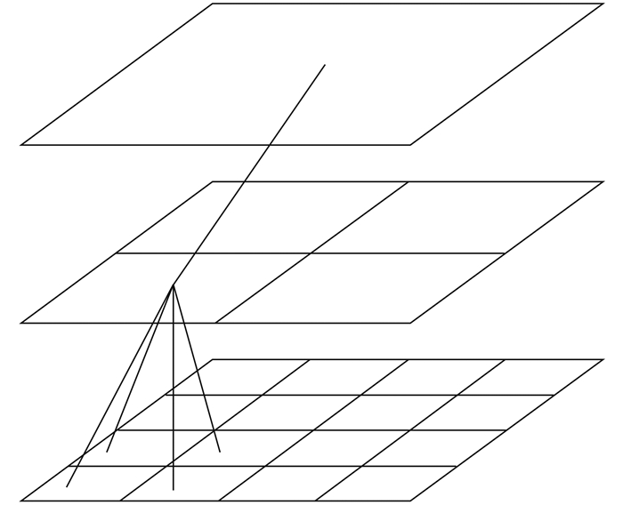
第1种情况是有在相同时间获取的多空间尺度遥感观测数据,需要估算对应的陆表参数。可以单独反演,但如果结合多空间尺度遥感观测数据进行联合反演,不同尺度的信息会相互传递以提高反演精度。比如Jiang等人(2016b)利用集合多尺度滤波器方法有效地提高了ETM+和MODIS数据的LAI反演精度。Van de Vyver和Roulin(2009)利用尺度递归估算方法计算降水量。这些多尺度估算过程能够用一个“树”状结构来表示(见图 1)。所有网格覆盖相同的区域,但是每个网格对应不同的空间分辨率。每个节点都与更细尺度或者更粗尺度上的节点相关联。多尺度估算方法不断地循环向上和向下更新。向上更新把信息从细尺度到粗尺度传递,相反向下更新把信息从粗尺度到细尺度传递。

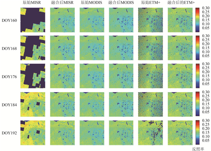
第2种情况是反演的不同尺度遥感产品可能存在系统误差、空间不连续和不确定性。利用多尺度数据产品融合方法,不同尺度上的信息被用来提高使用产品的精度和质量。He等人(2014b)利用多分辨率树(Multiresolution Tree-MRT)方法融合3种分辨率的反照率产品:MISR(1100 m),MODIS(500 m),ETM+(30 m)。结果表明多尺度数据融合填补了数据缺失,减少了系统误差和不确定性。图 2比较了5天3种产品在数据融合之前和之后的差别。大量的MISR缺失数据。陆地卫星的ETM +数据缺失主要是自2003年以来扫描线校正器的问题所造成的。结果表明,基于来自其他尺度数据的信息传递,MISR和ETM+数据的缺口可被完整填充。
Wang和Liang(2011,2014)应用经验正交函数(EOF)方法和最优内插方法融合MODIS和CYCLOPES叶面积指数产品,显著地改进了产品的精度和质量。
3 GLASS产品研发的新进展
自从2000年美国宇航局发射EOS计划的旗舰卫星TERRA以后,遥感界一个革命性的变化是数据中心不仅提供卫星观测的辐射数据(遥感低级产品),而且提供转换成的各种地球生物物理化学参数,即遥感高级产品。因为把遥感低级产品转换成高级产品的过程不仅需要复杂的反演算法,还需要一系列的辐射和几何方面的预处理方法,以及能够存储和计算海量遥感数据的软硬件系统。这个遥感高级产品的生产过程通常不是由单个用户来实施,而是由专门的团队通过相应的生产系统完成,生成的产品由发布系统向用户提供服务。比如MODIS数据的陆表产品,由分布在各个大学和研究所的科学委员会成员(science team member)发展算法,位于美国宇航局戈达德飞行中心的生产系统生成产品,绝大多数产品由位于南达科他州的美国地质调查局(USGS)的地球资源观测和科学中心(EROS)向全球发布。
在国家科技部“十一五”国家高技术研究发展计划(863计划)重点项目“全球陆表特征参量产品生成与应用研究”的支持下,北京师范大学联合国内多家优势单位,综合利用国内外卫星遥感数据源,生产了5种全球陆表卫星产品,即GLASS产品(Liang等,2013b,2013c),包含3年(2008年—2010年)的高时空分辨率的陆表下行辐射产品(下行太阳短波辐射和光合有效辐射)以及31年(1982年—2012年)的陆表反照率、发射率和叶面积指数产品。
GLASS产品具有长时间序列(近30年3种产品)、高空间分辨率(1—5 km)、高时间分辨率(两种3 h辐射产品)、高精度和高质量的独特特性。主要创新点和特色如下:(1)叶面积指数和陆表反照率产品的时间覆盖范围为1982年—2012年,把目前国际主流的同类产品向前推进了近20年;(2)发射率产品是目前世界首个全球宽波段发射率产品;(3)首次使用多源遥感数据(极轨卫星和静止卫星)反演得到全球陆表短波辐射和光合有效辐射产品。两种辐射产品是目前国际上空间分辨率最高的全球产品(5 km),比国际同类产品提高了至少一个数量级。GLASS产品在2012年地球观测组织第九次全会上对外发布,这是中国首次生产并向全球用户发布具有中国自主知识产权的全球陆表卫星遥感高级产品,弥补了中国陆表遥感高级产品的空白,改写了中国只是他人产品使用者的历史,同时也极大地促进了全球地球观测数据共享。
“十二五”期间,研究团队在国家高技术研究发展计划“全球生态系统与表面能量平衡特征参量生成与应用”的资助下,将GLASS产品拓展到12种(见表 1)。
表 1 GLASS产品列表
Table 1 List of the GLASS products
| 编号 | 产品名称 | 时间范围 | 空间范围 | 时间分辨率/d | 空间分辨率/km |
| 1 | LAI | 1982年—2014年 | 全球陆表 | 8 | 5 (2000年前) |
| 1 (2000年后) | |||||
| 2 | FPAR | 1982年—2014年 | 全球陆表 | 8 | 5 (2000年前) |
| 1 (2000年后) | |||||
| 3 | 反照率 | 1982年—2014年 | 全球陆表 | 8 | 5 (2000年前) |
| 1 (2000年后) | |||||
| 4 | 发射率 | 1982年—2014年 | 全球陆表 | 8 | 5 (2000年前) |
| 1 (2000年后) | |||||
| 5 | 地表温度 | 四期 | 全球陆表 | 瞬时 | 5 (2000年前) |
| 1 (2000年后) | |||||
| 6 | 长波净辐射 | 四期 | 全球陆表 | 8 | 5 (2000年前) |
| 1 (2000年后) | |||||
| 7 | 短波辐射 | 四期 | 全球陆表 | 1 | 5 |
| 8 | 光合有效辐射 | 四期 | 全球陆表 | 1 | 5 |
| 9 | 净辐射(日间) | 四期 | 全球陆表 | 1 | 5 |
| 10 | 植被覆盖度 | 四期 | 全球陆表 | 8 | 5 (2000年前) |
| 1 (2000年后) | |||||
| 11 | GPP | 四期 | 全球陆表 | 8 | 5 (2000年前) |
| 1 (2000年后) | |||||
| 12 | 潜热(ET) | 四期 | 全球陆表 | 8 | 5 (2000年前) |
| 1 (2000年后) | |||||
| 注:编号1、2、3、4的产品是已有的长时间序列产品,编号10、11、12的产品是最近被拓展为多年的长时间序列产品。 | |||||
GLASS产品由北京师范大学全球变化数据处理分析中心(http://www.bnu-datacenter.com/)和马里兰大学Global Land Cover Facility(www.landcover.org)分别向全球免费发布。到目前为止,GLASS数据产品已经被超过20个国家的研究人员使用,总下载次数超过5000次,数据下载总量约200 TB。此外,利用GLASS产品,科技部国家遥感中心发布了2012年、2013年、2015年度全球生态环境遥感监测报告,揭示了陆地植被的分布特征和变化趋势。这些报告发布可为保护生态环境、应对全球气候变化、及政府决策提供支撑。下面对几个典型的GLASS产品做一个简要的介绍。
3.1 叶面积指数
目前已有多个全球叶面积指数产品,几个主要产品见表 2。但是除了GLASS产品之外,每个产品都来源于同一个传感器,因而覆盖的时间尺度有限。不同产品之间还存在较大差异(Fang等,2013)。
表 2 全球主要的LAI和植被吸收的光合有效辐射比(FAPAR)产品
Table 2 Major global LAI/FAPAR products
| LAI/FAPAR产品 | 空间分辨率 | 时间分辨率/d | 时间范围 |
| CYCLOPES | 1/112°(≈ 1 km) | 10 | 1999年—2007年 |
| GIMMS3g | 1/12°(≈ 8 km) | 15 | 1981年—2011年 |
| MERIS | 300 m | 10 | 2002年—2012年 |
| MODIS | 1 km | 8 | 2000年至今 |
| GLASS | 0.05°(≈ 5km)/1 km | 8 | 1981年至今 |
GLASS LAI产品采用“多输入—多输出”的广义回归神经网络算法(Xiao等,2014,2016a),该算法最大的特色是使用一年的MODIS或AVHRR数据作为输入,一次性得到一年的LAI产品,用此方法能够很好地抓住植被的物候变化规律。此外,挑选了MODIS和CYCLOPES产品中数值接近的高质量反演的数据作为训练数据集。因此,相较于全球已有的LAI产品而言,GLASS LAI产品具有时间完整、空间连续、精度较高等特点。
GLASS叶面积指数产品已经得到了广泛的应用,比如验证地球系统模式的模拟精度(Bao等,2014),研究干旱区植被动态及其对气候效应(Jiapaer等,2015),计算植被总初级生产力(GPP)和蒸散(ET)(Liu等,2015b),计算植被吸收的光合有效辐射比(Xiao等,2015a),植被覆盖度(Xiao等,2016c)和森林ET(Tian等,2015),评价水文参数数值模拟(Tesemma等,2015),确定全球森林GPP被高估(Ma等,2015),监测和归因分析中国区域植被变绿的趋势(Piao等,2015)以及推广到全球尺度(Zhu等,2016)。
3.2 植被吸收的光合有效辐射比(FAPAR)
全球植被吸收的光合有效辐射比的遥感产品见表 2。基于最近的验证结果(Martínez等,2013;Pickett-Heaps等,2014;Tao等,2015),每个产品都有一定的不确定性,不同产品之间的差异也很大。GLASS FAPAR产品是基于GLASS叶面积指数产品和其他信息计算生成(Xiao等,2015a),精度较高,时空连续性也很好,这种方法也用于VIIRS和其他传感器数据(Xiao等,2015b,2016b)。
3.3 植被覆盖度
全球植被覆盖度卫星遥感产品较少,主要产品如表 3所示。GLASS植被覆盖度产品利用广义回归神经网络算法(Jia等,2015)生产而成,用于训练的16980个样本分布在全球。其精度被证明高于同类产品。类似的算法也被应用到中国的高分数据(Jia等,2016)。
表 3 现有全球植被覆盖度产品
Table 3 Existing global FVC products
| 传感器产品 | 时间范围 | 时间分辨率/d | 空间分辨率 |
| AVHRR/SPOT VGT | 1981年至今 | 10 | 1981年—2000年(0.05°) 1999至今(1 km) |
| POLDER | 1996年—1997年, 2003年 |
10 | 6 km |
| SPOT VGT | 1998年—2007年 | 10 | 1 km |
| GLASS | 1981年至今 | 8 | 1981年—2000年(0.05°) 2000年至今(500 m) |
3.4 短波反照率
国际上有代表性的全球反照率产品包含MODIS、POLDER、MERIS等(图 3),但是这些产品中仍然存在很多问题,其中最大的问题是由于基于单一传感器数据都不是长时间序列产品。
通常的反照率算法共有大气校正、地表方向反射率定模和狭宽波段转换3个过程,每个过程的计算均会产生误差,误差的积累将会影响最终结果。采用基于波段反射率直接计算反照率的算法(Liang,2003;Liang等,1999),首先分别利用大气顶端反射率和地表反射率来生产反照率初级产品(Qu等,2015),然后通过融合的办法生成最终产品(Liu等,2013a,2013b)。这是目前世界上第一次用多算法集成的方法生成全球陆表产品,用以提高产品精度。
GLASS反照率产品得到了广泛的应用,比如它被用来揭示格陵兰岛冰雪融化与气温升高的关系(He等,2013);计算冰雪覆盖季相变化(Chen等,2015c)和森林扰动(Zhang和Liang,2014)的辐射强迫;确定全球地表反照率均态(He等,2014a)。
3.5 宽波段发射率
目前发射率数据缺乏有效的观测,在气候模式中通常将其设置为常数或者采用简单参数化方案表征,已有的发射率产品(表 4)存在分辨率低、无法反映地表发射率真实变化等不足,长时间序列、高时空分辨率的全球陆表宽波段发射率遥感产品仍属空白。
表 4 现有的全球发射率产品
Table 4 Existing global emissivity products
| 作者 | 方法 | 分辨率 | 光谱范围 | 用途 | 缺点 |
| Wilber等人 | 根据地表类型赋值 | 全球10’×10’ | 12个波段和宽波段 (5—100 μm) |
辐射传输模式和 NASA云与地球 辐射能量系统 |
无法反映地表发 射率的真实变化 |
| Seemann等人 | 基线拟合法 | 全球0.05°月平均 2000年—2010年 |
3.6—14.3 μm内10个 波段发射率 |
改善大气温湿度 廓线反演精度 |
单一传感器;未验证 |
| Pequignot等人 | 多光谱方法 | 全球南北纬30° 以内1°× 1°月平均 2003.4—2006.3 |
3.7—14 μm; 0.05 μm | — | 同上;空间分辨率太粗 |
GLASS产品针对裸土提出了利用热红外波段发射率与可见光/近红外波段反照率/反射率的多元线性回归模型,结果优于现有方法中利用热红外波段发射率仅与红光波段反射率建立线性关系模型的结果(Cheng和Liang,2014);针对植被覆盖,兼顾算法计算效率和物理基础,提出使用4SAIL辐射传输模型构建宽波段发射率查找表,以组分发射率(土壤发射率、叶片发射率)和LAI为索引,查表得到植被覆盖像元宽波段发射率(Cheng等,2016a),它能够反映植被丰度的季节变化,而这是主流发射率产品(ASTER和MODIS发射率产品)所不能的。
3.6 下行短波辐射
短波辐射是研究陆表辐射收支平衡及其对气候影响的重要参数,国内外现有的全球下行短波辐射产品(参见表 5)空间分辨率较低,无法满足地表科学的应用需求,其精度也有待极大地提高。
表 5 现有全球下行短波辐射产品
Table 5 Existing global incident shortwave radiation products
| 产品 | 空间分辨率 | 时间分辨率/h | 时间范围 |
| ISCCP | 280 km | 3 | 1983年—2008年 |
| GEWEX-SRB | 1° | 3 | 1983年—2007年 |
| CERES | 140 km | 3 | 1997年至今 |
| GLASS | 5 km | 3 | 2008年—2010年 |
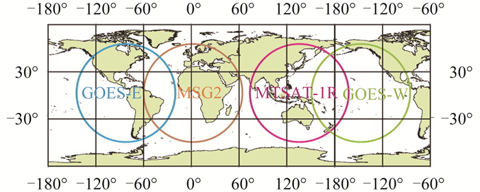
为了生成高时空分辨率全球覆盖的下行短波辐射产品,首次联合使用多个静止卫星(GOES、MSG、MTSAT等)遥感数据和极轨卫星(MODIS)数据作为产品的输入数据,图 4显示了使用的静止卫星覆盖的范围。产品生产算法采用基于查找表业务化生产方法(Zhang等,2014a),将地表高程加入查找表中,提高了在高原区域估算精度。在保持算法反演精度的前提下,大幅度提高了全球辐射产品的空间分辨率。GLASS下行短波辐射产品是目前是世界上空间分辨率最高的全球陆表下行短波辐射产品,也具有较高的精度(Huang等,2013)。
3.7 光合有效辐射
目前已有的光合有效辐射与下行短波辐射产品情况类似,空间分辨率较低,而且产品数更少。光合有效辐射采用了与下行短波辐射相似的基于查找表的业务生产方法(Zhang等,2014a),具有与下行短波辐射相似的算法先进性与特色。为实现全球产品生产,结合覆盖全球范围的多颗静止卫星,针对气溶胶类型、水云模式、云光学厚度,分别构建下行光合有效辐射和上述各云光学物理参数的查找表(LUT-A),以及云光学物理参数与传感器敏感波段间的查找表(LUT-B);验证结果表明该算法不但可以提高产品的空间分辨率,而且产品精度也有明显的提高。高精度、高分辨率辐射产品能够提高GPP的计算精度(Cai等,2014)。
3.8 长波净辐射
长波净辐射是估算地表净辐射的两个分量之一。现有长波辐射产品空间分辨率粗,精度差,难以满足多学科的应用需求。GLASS长波净辐射是晴空下的瞬时产品。GLASS长波净辐射产品采用分量模式,分别反演上行长波辐射和下行长波辐射,然后相减得到长波净辐射。上行长波辐射采用混合算法(Cheng和Liang,2016),直接由MODIS大气层顶辐亮度估算,全球尺度上算法的验证精度:偏差为–0.31 Wm–2,均方根误差为19.92 Wm–2,优于大多文献中报告的结果。下行长波辐射采用新的参数化方案估算,将其表达为上行长波辐射和大气含水量的非线性函数。全球尺度上算法验证精度:偏差为0.514 Wm–2,均方根误差为25.543 Wm–2。验证结果表明GLASS长波净辐射的偏差为–0.054 Wm–2,均方根误差为30.079 Wm–2。
3.9 净辐射
全球地表净辐射遥感产品不多,主要有CERES,GEWEX和ISCCP这3个产品,但是它们的空间分辨率最高是1°,难以满足各种陆面的应用研究。GLASS净辐射产品是每天白天的平均值,其空间分辨率是5 km。通常净辐射遥感产品是从每个分量计算而得,即短波净辐射和长波净辐射之和(Wang等,2015b)。短波净辐射由下行太阳辐射和地面反照率产品计算,长波净辐射是上行和下行长波辐射之差。由于云等影响,通常难以直接计算连续的全天候长波净辐射。GLASS净辐射产品算法是将短波净辐射转换成总的净辐射,短波净辐射从大气顶的观测数据直接计算(Wang等,2015a,2015c),或者从下行短波辐射(Zhang等,2014a)和反照率(Wang等,2015d)计算。在经过比较不同的线性公式(Jiang等,2015)和机器学习算法(Jiang等,2014)之后,MARS算法被选中(Jiang等,2016a)。利用观测数据的验证结果表明GLASS净辐射产品的均方根误差在30 Wm–2左右。
3.10 初级生产力
GLASS-GPP产品采用贝叶斯多算法集成方法,首先评价了目前国际上应用广泛的8个光能利用率模型:CASA(Carnegie-Ames-Stanford Approach)、CFix、CFlux、EC-LUE(Eddy Covariance-Light Use Efficiency)、MODIS、VPM(Vegetation Photosynthesis Model)、VPRM和Two-leaf。其中EC-LUE模型是基于涡度相关碳通量站点资料发展起来的光能利用率模型(Yuan等,2007,2010),算法发展和验证是基于全球涡相关通量站点数据,站点数目为155个,包含了9种陆地生态系统类型:常绿阔叶林、常绿针叶林、落叶阔叶林、混交林、温带草地、热带稀树草原、灌木、农田和苔原。初步验证结果表明各个模型表现相对一致,回归集成方法显示了最高的模拟能力。GLASS-GPP产品的生产正在采用EC-LUE,CFlux,TL-LUE和VPRM这4种模型的集合方案。
3.11 潜热通量
遥感估算地表潜热通量的方法有很多,比如基于地表能量平衡的物理模型、经验统计算法、Penman-Monteith算法、遥感三角形方法和数据同化方法等。尽管目前全球的潜热通量产品类型很多,包括卫星产品、再分析资料、陆面模型模拟、水文模型模拟以及数据同化数据集等,它们之间的差异很大(Feng等,2015;Mueller等,2011;Wang和Dickinson,2012;Yao等,2016),但是高分辨率的全球卫星产品还很少。MODIS ET产品恐怕是最典型的,但是它的精度需要很大的改进(Chen等,2014b)。
GLASS潜热通量产品是使用贝叶斯模型平均(BMA)方法集成5种算法而生成(Yao等,2014),其中包含MODIS产品算法,这确保GLASS产品的精度和质量有可能优于MODIS产品和其他的单一算法产品。
4 气候数据集
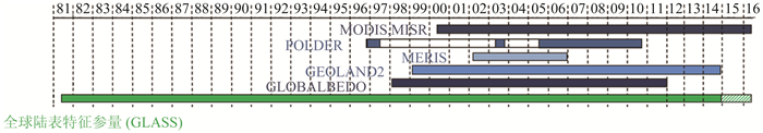
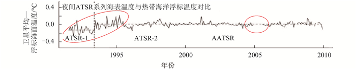
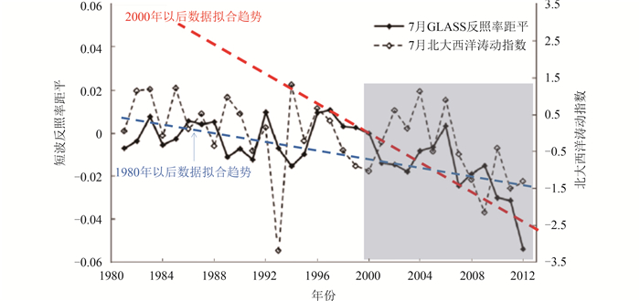
当前卫星遥感产品主要由单一卫星计划、单一传感器数据生成,时间跨度有限,无法检测气候变化趋势,且由不同数据源生成的产品之间存在显著不一致性问题。图 5是一个典型的例子,右边的圆圈显示数据产品的不连续性,左边的圆圈显示数据产品的不确定性和不一致性的问题。对于环境监测,特别是气候变化监测,长时间序列遥感产品是必须的。图 6显示了格林兰岛地面反射率的长时间变化。近年来,由于地面气温升高,冰雪融化,反照率显著下降。如果用2000年以后NASA MODIS反照率数据拟合的趋势,与用GLASS反照率拟合的30多年的趋势差别很大,它充分显示了长时间序列遥感产品的重要性。
为此,美国国家研究委员会(NRC)2004年提出了气候数据集(CDR)的概念(NRC,2004)。CDR定义为可用于确定气候变率和气候变化,具有足够时间长度、一致性和连续性的长时间序列数据。全球尺度上,卫星遥感是生成CDR的唯一手段。
CDR的概念得到了许多国际组织的响应和支持。国际空间机构,以NOAA和ESA为代表,陆续开始研发CDRs。例如NOAA生成了9个大气CDRs、4个海洋CDRs和4个陆表CDRs。ESA于2010年启动了气候变化计划(CCI)(Hollmann等,2013),计划2017年前生成4个大气CDRs、4个海洋CDRs和5个陆表CDRs,ESA将于2017年启动CCI+计划,在原有基础上,增加10个CDRs。CDR类型明显不足,且分布不均,如复杂性和异质性最强陆表,CDR小于5个。相当长的时间内,国外规划的气候数据集仍不能满足全球变化关键过程监测的需求。
在“十三五”全球变化专项计划中,“全球气候数据集生成及气候变化关键过程和要素监测”的项目已于近期立项,届时将生产出中国自主产权的多种大气、海洋和陆表气候数据集。
5 结语
陆表定量遥感的核心是研究如何从遥感观测数据中定量地估算地表各种地球物理、化学和生物参数,并且生成相应的遥感高级产品。这需要精确有效的反演算法,处理海量数据的软硬件产品生产系统和相应的用户服务。本文重点评述了反演方法和数据产品生成的新进展。先进的遥感反演方法是生成遥感高级产品的关键,及时了解反演算法发展的动态,不仅对反演算法的发展者非常重要,对遥感产品的使用者也非常有益。
在反演方法方面,主要讨论了两个方面:第一是评述各种机器学习方法在反演中的新进展;第二是为了克服遥感病态反演问题的各种正则化方法。尽管是分开讨论的,但是这些方法常被组合使用。
在遥感产品方面,介绍了GLASS产品的算法、特性和应用情况,对世界上气候数据集的生成情况进行了详细评述。气候数据集是具有足够时间长度(通常在30年左右)、一致性和连续性的长时间序列数据。以遥感为主体的气候数据集对研究气候变化等许多应用都是具有重大意义。
尽管对环境遥感有了大量投资,但是几乎在遥感的所有方面都缺少紧密的结合:传感器硬件系统、遥感科学的基础理论研究、反演算法研究、信息系统、信息服务与应用。比如中国空间基础设施将计划发射60多颗卫星,这些卫星基本上没有连成观测网络,而且绝大多数遥感用户都没有参与卫星平台和传感器设计的讨论。目前遥感反演算法基本都依靠1维的辐射传输模型,常常与3维的真实世界差别太远,迫切需要计算效率高、有效表征3维真实场景的辐射传播模型。数据中心的信息系统需要连续更新,云存储和云计算需要尽快发展。大容量的遥感数据在线传输依然很慢,用户搜索多层菜单也难以发现所需产品。尽管数据共享早已成为共识,但是数据中心还常常对用户设置许多障碍,比如限制免费数据下载量,有偿使用数据等。
遥感发展最终的驱动力是遥感应用,但是遥感发展与遥感应用之间还存在显著的断层现象。遥感科学家开发的许多高级产品还没有被广泛使用,许多陆表过程模型和决策支持系统所需的变量还没有产生产品,产品的精度和应用要求还未达到一致,即使是相同的变量在遥感反演算法和应用模型中可能会有不同的定义。
遥感产品的精度评价还需要大量的工作,这需要更多广泛空间分布的、连续的、多要素的地面观测。对于许多要素,地面测量数据的不足严重影响了反演算法的的研发和产品验证,因而制约了陆表定量遥感的发展。
简言之,在大量投资的支撑下,中国遥感已经有了长足的发展,也得到了巨大的社会效益。海量的遥感数据已经获得,但也提出了巨大的挑战。发展先进的传感器和系统以解决应用问题迫在眉睫,最佳集成来自各种传感器的观测数据以及其他辅助测量数据的方法亟待关注。为了实现集成,发展新的模型和算法,如数据融合和数据同化是至关重要的。迫切需要发展计算简化的陆表辐射传输模型,以用于从卫星数据中反演陆表变量。
参考文献(References)
-
Ahmed O S, Franklin S E, Wulder M A, White J C.2015.Characterizing stand-level forest canopy cover and height using Landsat time series, samples of airborne LiDAR, and the Random Forest algorithm. ISPRS Journal of Photogrammetry and Remote Sensing, 101 : 89–101. DOI: 10.1016/j.isprsjprs.2014.11.007.
-
Ali I, Greifeneder F, Stamenkovic J, Neumann M, Notarnicola C.2015.Review of machine learning approaches for biomass and soil moisture retrievals from remote sensing data. Remote Sensing, 7 (12): 16398–16421. DOI: 10.3390/rs71215841.
-
Atzberger C.2004.Object-based retrieval of biophysical canopy variables using artificial neural nets and radiative transfer models. Remote Sensing of Environment, 93 (1/2): 53–67. DOI: 10.1016/j.rse.2004.06.016.
-
Atzberger C, Richter K.2012.Spatially constrained inversion of radiative transfer models for improved LAI mapping from future Sentinel-2 imagery. Remote Sensing of Environment, 120 : 208–218. DOI: 10.1016/j.rse.2011.10.035.
-
Axelsson C, Skidmore A K, Schlerf M, Fauzi A, Verhoef W.2013.Hyperspectral analysis of mangrove foliar chemistry using PLSR and support vector regression. International Journal of Remote Sensing, 34 (5): 1724–1743. DOI: 10.1080/01431161.2012.725958.
-
Aznay O, Zagolski F, Santer R.2011.A new climatology for remote sensing over land based on the inherent optical properties. International Journal of Remote Sensing, 32 (10): 2851–2885. DOI: 10.1080/01431161003745616.
-
Banzon V F, Reynolds R W, Stokes D, Xue Y.2014.A 1/4°-spatial-resolution daily sea surface temperature climatology based on a blended satellite and in situ analysis. Journal of Climate, 27 (21): 8221–8228. DOI: 10.1175/JCLI-D-14-00293.1.
-
Bao Y, Gao Y H, Lü S H, Wang Q X, Zhang S B, Xu J W, Li R Q, Li S S, Ma D, Meng X H, Chen H, Chang Y.2014.Evaluation of CMIP5 earth system models in reproducing leaf area index and vegetation cover over the Tibetan Plateau. Journal of Meteorological Research, 28 (6): 1041–1060. DOI: 10.1007/s13351-014-4023-5.
-
Barbosa J M, Melendez-Pastor I, Navarro-Pedreño J, Bitencourt M D.2014.Remotely sensed biomass over steep slopes:an evaluation among successional stands of the Atlantic Forest, Brazil. ISPRS Journal of Photogrammetry and Remote Sensing, 88 : 91–100. DOI: 10.1016/j.isprsjprs.2013.11.019.
-
Baret F, Hagolle O, Geiger B, Bicheron P, Miras B, Huc M, Berthelot B, Niño F, Weiss M, Samain O, Roujean J L, Leroy M.2007.LAI, fAPAR and fCover CYCLOPES global products derived from VEGETATION:part 1:principles of the algorithm. Remote Sensing of Environment, 110 (3): 275–286. DOI: 10.1016/j.rse.2007.02.018.
-
Baret F and Buis S.2008.Estimating canopy characteristics from remote sensing observations:review of methods and associated problems//Liang S L, ed.Advances in Land Remote Sensing:System, Modeling, Inversion and Application.Netherlands:Springer:173-201 [DOI:10.1007/978-1-4020-6450-0_7]
-
Bechtel B.2015.A new global climatology of annual land surface temperature. Remote Sensing, 7 (3): 2850–2870. DOI: 10.3390/rs70302850.
-
Beck P S A, Atzberger C, Høgda K A, Johansen B, Skidmore A K.2006.Improved monitoring of vegetation dynamics at very high latitudes:a new method using MODIS NDVI. Remote Sensing of Environment, 100 (3): 321–334. DOI: 10.1016/j.rse.2005.10.021.
-
Belgiu M, Drăguţ L.2016.Random forest in remote sensing:a review of applications and future directions. ISPRS Journal of Photogrammetry and Remote Sensing, 114 : 24–31. DOI: 10.1016/j.isprsjprs.2016.01.011.
-
Blackard J A, Finco M V, Helmer E H, Holden G R, Hoppus M L, Jacobs D M, Lister A J, Moisen G G, Nelson M D, Riemann R, Ruefenacht B, Salajanu D, Weyermann D L, Winterberger K C, Brandeis T J, Czaplewski R L, McRoberts R E, Patterson P L, Tymcio R P.2008.Mapping U. S.forest biomass using nationwide forest inventory data and moderate resolution information.Remote Sensing of Environment, 112 (4): 1658–1677. DOI: 10.1016/j.rse.2007.08.021.
-
Broxton P D, Zeng X B, Sulla-Menashe D, Troch P A.2014.A global land cover climatology using MODIS data. Journal of Applied Meteorology and Climatology, 53 (6): 1593–1605. DOI: 10.1175/JAMC-D-13-0270.1.
-
Cai W W, Yuan W P, Liang S L, Zhang X T, Dong W J, Xia J Z, Fu Y, Chen Y, Liu D, Zhang Q.2014.Improved estimations of gross primary production using satellite-derived photosynthetically active radiation. Journal of Geophysical Research:Biogeosciences, 119 (1): 110–123. DOI: 10.1002/2013JG002456.
-
Caicedo J P R, Verrelst J, Muñoz-Marí J, Moreno J, Camps-Valls G.2014.Toward a semiautomatic machine learning retrieval of biophysical parameters. IEEE Journal of Selected Topics in Applied Earth Observations and Remote Sensing, 7 (4): 1249–1259. DOI: 10.1109/JSTARS.2014.2298752.
-
Chen B, Huang B, Xu B.2015a.Comparison of spatiotemporal fusion models:a review. Remote Sensing, 7 (2): 1798–1835. DOI: 10.3390/rs70201798.
-
Chen J, Quan W T, Cui T W, Song Q J, Lin C S.2014a.Remote sensing of absorption and scattering coefficient using neural network model:development, validation, and application. Remote Sensing of Environment, 149 : 213–226. DOI: 10.1016/j.rse.2014.04.013.
-
Chen W J, Huang C L, Shen H F, Li X.2015b.Comparison of ensemble-based state and parameter estimation methods for soil moisture data assimilation. Advances in Water Resources, 86 : 425–438. DOI: 10.1016/j.advwatres.2015.08.003.
-
Chen X N, Liang S L, Cao Y F, He T.2016.Distribution, attribution, and radiative forcing of snow cover changes over China from 1982 to 2013. Climatic Change : 1–15. DOI: 10.1007/s10584-016-1688-z.
-
Chen X N, Liang S L, Cao Y F, He T, Wang D D.2015c.Observed contrast changes in snow cover phenology in northern middle and high latitudes from 2001-2014. Scientific Reports, 5 : 16820 DOI: 10.1038/srep16820.
-
Chen Y, Xia J Z, Liang S L, Feng J M, Fisher J B, Li X, Li X L, Liu S G, Ma Z G, Miyata A, Mu Q Z, Sun L, Tang J W, Wang K C, Wen J, Xue Y J, Yu G R, Zha T G, Zhang L, Zhang Q, Zhao T B, Zhao L, Yuan W P.2014b.Comparison of satellite-based evapotranspiration models over terrestrial ecosystems in China. Remote Sensing of Environment, 140 : 279–293. DOI: 10.1016/j.rse.2013.08.045.
-
Chen Y, Yuan W P, Xia J Z, Fisher J B, Dong W J, Zhang X T, Liang S L, Ye A Z, Cai W W, Feng J M.2015d.Using Bayesian model averaging to estimate terrestrial evapotranspiration in China. Journal of Hydrology, 528 : 537–549. DOI: 10.1016/j.jhydrol.2015.06.059.
-
Chen Z Q, Shi R H, Zhang S P.2013.An artificial neural network approach to estimate evapotranspiration from remote sensing and AmeriFlux data. Frontiers of Earth Science, 7 (1): 103–111. DOI: 10.1007/s11707-012-0346-7.
-
Cheng J, Liang S L.2014.Estimating the broadband longwave emissivity of global bare soil from the MODIS shortwave albedo product. Journal of Geophysical Research:Atmospheres, 119 (2): 614–634. DOI: 10.1002/2013JD020689.
-
Cheng J, Liang S L.2016.Global estimates for high-spatial-resolution clear-sky land surface upwelling longwave radiation from MODIS data. IEEE Transactions on Geoscience and Remote Sensing, 54 (7): 4115–4129. DOI: 10.1109/TGRS.2016.2537650.
-
Cheng J, Liang S L, Verhoef W, Shi L P, Liu Q.2016a.Estimating the hemispherical broadband longwave emissivity of global vegetated surfaces using a radiative transfer model. IEEE Transactions on Geoscience and Remote Sensing, 54 (2): 905–917. DOI: 10.1109/TGRS.2015.2469535.
-
Cheng Z Q, Meng J H, Wang Y M.2016b.Improving spring maize yield estimation at field scale by assimilating time-series HJ-1 CCD data into the WOFOST model using a new method with fast algorithms. Remote Sensing, 8 (4): 303 DOI: 10.3390/rs8040303.
-
Dash J, Ogutu B O.2016.Recent advances in space-borne optical remote sensing systems for monitoring global terrestrial ecosystems. Progress in Physical Geography, 40 (2): 322–351. DOI: 10.1177/0309133316639403.
-
Donmez C, Berberoglu S, Erdogan M A, Tanriover A A, Cilek A.2015.Response of the regression tree model to high resolution remote sensing data for predicting percent tree cover in a Mediterranean ecosystem. Environmental Monitoring and Assessment, 187 (2): 4 DOI: 10.1007/s10661-014-4151-5.
-
Fan L, Xiao Q, Wen J G, Liu Q, Jin R, You D Q, Li X W.2015.Mapping high-resolution soil moisture over heterogeneous cropland using multi-resource remote sensing and ground observations. Remote Sensing, 7 (10): 13273–13297. DOI: 10.3390/rs71013273.
-
Fang H L, Jiang C Y, Li W J, Wei S S, Baret F, Chen J M, Garcia-Haro J, Liang S L, Liu R G, Myneni R B, Pinty B, Xiao Z Q, Zhu Z C.2013.Characterization and intercomparison of global moderate resolution leaf area index (LAI) products:analysis of climatologies and theoretical uncertainties. Journal of Geophysical Research:Biogeosciences, 118 (2): 529–548. DOI: 10.1002/jgrg.20051.
-
Fang H L, Liang S L, Kim H Y, Townshend J R, Schaaf C L, Strahler A H, Dickinson R E.2007.Developing a spatially continuous 1 km surface albedo data set over North America from Terra MODIS products. Journal of Geophysical Research, 112 (D20): D20206 DOI: 10.1029/2006JD008377.
-
Fang H L, Liang S L, Townshend J R, Dickinson R.2008.Spatially and temporally continuous LAI data sets based on an integrated filtering method:examples from North America. Remote Sensing of Environment, 112 (1): 75–93. DOI: 10.1016/j.rse.2006.07.026.
-
Feng F, Chen J Q, Li X L, Yao Y J, Liang S L, Liu M, Zhang N N, Guo Y, Yu J, Sun M M.2015.Validity of five satellite-based latent heat flux algorithms for semi-arid ecosystems. Remote Sensing, 7 (12): 16733–16755. DOI: 10.3390/rs71215853.
-
Filippi A M, Güneralp İ, Randall J.2014.Hyperspectral remote sensing of aboveground biomass on a river meander bend using multivariate adaptive regression splines and stochastic gradient boosting. Remote Sensing Letters, 5 (5): 432–441. DOI: 10.1080/2150704X.2014.915070.
-
Fischer A.1994.A model for the seasonal variations of vegetation indices in coarse resolution data and its inversion to extract crop parameters. Remote Sensing of Environment, 48 (2): 220–230. DOI: 10.1016/0034-4257(94)90143-0.
-
Gao F, Masek J, Schwaller M, Hall F.2006.On the blending of the Landsat and MODIS surface reflectance:predicting daily Landsat surface reflectance. IEEE Transactions on Geoscience and Remote Sensing, 44 (8): 2207–2218. DOI: 10.1109/TGRS.2006.872081.
-
García-Gutiérrez J, Martínez-Álvarez F, Troncoso A, Riquelme J C.2015.A comparison of machine learning regression techniques for LiDAR-derived estimation of forest variables. Neurocomputing, 167 : 24–31. DOI: 10.1016/j.neucom.2014.09.091.
-
Gholizadeh H, Robeson S M, Rahman A F.2015.Comparing the performance of multispectral vegetation indices and machine-learning algorithms for remote estimation of chlorophyll content:a case study in the Sundarbans mangrove forest. International Journal of Remote Sensing, 36 (12): 3114–3133. DOI: 10.1080/01431161.2015.1054959.
-
Gómez C, Wulder M A, Montes F, Delgado J A.2012.Modeling forest structural parameters in the mediterranean pines of central Spain using QuickBird-2 Imagery and Classification and Regression Tree Analysis (CART). Remote Sensing, 4 (12): 135–159. DOI: 10.3390/rs4010135.
-
Gómez-Dans J L, Lewis P E, Disney M.2016.Efficient emulation of radiative transfer codes using gaussian processes and application to land surface parameter inferences. Remote Sensing, 8 (2): 119 DOI: 10.3390/rs8020119.
-
Halperin J, LeMay V, Coops N, Verchot L, Marshall P, Lochhead K.2016.Canopy cover estimation in miombo woodlands of Zambia:comparison of Landsat 8 OLI versus RapidEye imagery using parametric, nonparametric, and semiparametric methods. Remote Sensing of Environment, 179 : 170–182. DOI: 10.1016/j.rse.2016.03.028.
-
Han X J, Li X, Rigon R, Jin R, Endrizzi S.2015.Soil moisture estimation by assimilating L-band microwave brightness temperature with geostatistics and observation localization. PLo S One, 10 (1): e0116435 DOI: 10.1371/journal.pone.0116435.
-
He T, Liang S L, Song D X.2014a.Analysis of global land surface albedo climatology and spatial-temporal variation during 1981-2010 from multiple satellite products. Journal of Geophysical Research:Atmospheres, 119 (17): 10281–10298. DOI: 10.1002/2014JD021667.
-
He T, Liang S L, Wang D D, Shuai Y M, Yu Y Y.2014b.Fusion of satellite land surface albedo products across scales using a multiresolution tree method in the North Central United States. IEEE Transactions on Geoscience and Remote Sensing, 52 (6): 3428–3439. DOI: 10.1109/TGRS.2013.2272935.
-
He T, Liang S L, Wang D D, Wu H Y, Yu Y Y, Wang J D.2012.Estimation of surface albedo and directional reflectance from Moderate Resolution Imaging Spectroradiometer (MODIS) observations. Remote Sensing of Environment, 119 : 286–300. DOI: 10.1016/j.rse.2012.01.004.
-
He T, Liang S L, Yu Y Y, Wang D D, Gao F, Liu Q.2013.Greenland surface albedo changes in July1981-2012 from satellite observations. Environmental Research Letters, 8 (4): 044043 DOI: 10.1088/1748-9326/8/4/044043.
-
Hermance J F.2007.Stabilizing high-order, non-classical harmonic analysis of NDVI data for average annual models by damping model roughness. International Journal of Remote Sensing, 28 (12): 2801–2819. DOI: 10.1080/01431160600967128.
-
Hollmann R, Merchant C J, Saunders R, Downy C, Buchwitz M, Cazenave A, Chuvieco E, Defourny P, de Leeuw G, Forsberg R, Holzer-Popp T, Paul F, Sandven S, Sathyendranath S, van Roozendael M, Wagner W.2013.The esa climate change initiative:satellite data records for essential climate variables. Bulletin of the American Meteorological Society, 94 (10): 1541–1552. DOI: 10.1175/BAMS-D-11-00254.1.
-
Houborg R, Soegaard H, Boegh E.2007.Combining vegetation index and model inversion methods for the extraction of key vegetation biophysical parameters using Terra and Aqua MODIS reflectance data. Remote Sensing of Environment, 106 (1): 39–58. DOI: 10.1016/j.rse.2006.07.016.
-
Huang G H, Wang W Z, Zhang X T, Liang S L, Liu S M, Zhao T B, Feng J M, Ma Z G.2013.Preliminary validation of GLASS-DSSR products using surface measurements collected in arid and semi-arid regions of China. International Journal of Digital Earth, 6 (S1): 50–68. DOI: 10.1080/17538947.2013.825655.
-
Huang J X, Ma H Y, Su W, Zhang X D, Huang Y B, Fan J L, Wu W B.2015a.Jointly assimilating MODIS LAI, ET products into the SWAP model for winter wheat yield estimation. IEEE Journal of Selected Topics in Applied Earth Observations and Remote Sensing, 8 (8): 4060–4071. DOI: 10.1109/JSTARS.2015.2403135.
-
Huang J X, Sedano F, Huang Y B, Ma H Y, Li X L, Liang S L, Tian L Y, Zhang X D, Fan J L, Wu W B.2016.Assimilating a synthetic Kalman filter leaf area index series into the WOFOST model to improve regional winter wheat yield estimation. Agricultural and Forest Meteorology, 216 : 188–202. DOI: 10.1016/j.agrformet.2015.10.013.
-
Huang J X, Tian L Y, Liang S L, Ma H Y, Becker-Reshef I, Huang Y B, Su W, Zhang X D, Zhu D H, Wu W B.2015b.Improving winter wheat yield estimation by assimilation of the leaf area index from Landsat TM, MODIS data into the WOFOST model. Agricultural and Forest Meteorology, 204 : 106–121. DOI: 10.1016/j.agrformet.2015.02.001.
-
Hüsler F, Jonas T, Riffler M, Musial J P, Wunderle S.2014.A satellite-based snow cover climatology (1985-2011) for the European Alps derived from AVHRR data. The Cryosphere, 8 (1): 73–90. DOI: 10.5194/tc-8-73-2014.
-
Hutengs C, Vohland M.2016.Downscaling land surface temperatures at regional scales with random forest regression. Remote Sensing of Environment, 178 : 127–141. DOI: 10.1016/j.rse.2016.03.006.
-
Jamet C, Loisel H, Dessailly D.2012.Retrieval of the spectral diffuse attenuation coefficient Kd (λ) in open and coastal ocean waters using a neural network inversion. Journal of Geophysical Research:Oceans, 117 (C10): C10023 DOI: 10.1029/2012JC008076.
-
Jia K, Liang S L, Gu X F, Baret F, Wei X Q, Wang X X, Yao Y J, Yang L Q, Li Y W.2016.Fractional vegetation cover estimation algorithm for Chinese GF-1 wide field view data. Remote Sensing of Environment, 177 : 184–191. DOI: 10.1016/j.rse.2016.02.019.
-
Jia K, Liang S L, Liu S H, Li Y W, Xiao Z Q, Yao Y J, Jiang B, Zhao X, Wang X X, Xu S, Cui J.2015.Global land surface fractional vegetation cover estimation using general regression neural networks from MODIS surface reflectance. IEEE Transactions on Geoscience and Remote Sensing, 53 (9): 4787–4796. DOI: 10.1109/TGRS.2015.2409563.
-
Jiang B, Liang S L, Ma H, Zhang X T, Xiao Z Q, Zhao X, Jia K, Yao Y J, Jia A L.2016a.GLASS daytime all-wave net radiation product:algorithm development and preliminary validation. Remote Sensing, 8 (3): 222 DOI: 10.3390/rs8030222.
-
Jiang B, Zhang Y, Liang S L, Wohlfahrt G, Arain A, Cescatti A, Georgiadis T, Jia K, Kiely G, Lund M, Montagnani L, Magliulo V, Ortiz P S, Oechel W, Vaccari F P, Yao Y J, Zhang X T.2015.Empirical estimation of daytime net radiation from shortwave radiation and ancillary information. Agricultural and Forest Meteorology, 211-212 : 23–36. DOI: 10.1016/j.agrformet.2015.05.003.
-
Jiang B, Zhang Y, Liang S L, Zhang X T, Xiao Z Q.2014.Surface daytime net radiation estimation using artificial neural networks. Remote Sensing, 6 (11): 11031–11050. DOI: 10.3390/rs61111031.
-
Jiang J Y, Xiao Z Q, Wang J D, Song J L.2016b.Multiscale estimation of leaf area index from satellite observations based on an ensemble multiscale filter. Remote Sensing, 8 (3): 229 DOI: 10.3390/rs8030229.
-
Jiapaer G, Liang S L, Yi Q X, Liu J P.2015.Vegetation dynamics and responses to recent climate change in Xinjiang using leaf area index as an indicator. Ecological Indicators, 58 : 64–76. DOI: 10.1016/j.ecolind.2015.05.036.
-
Ke Y H, Im J, Park S, Gong H L.2016.Downscaling of MODIS one kilometer evapotranspiration using landsat-8 data and machine learning approaches. Remote Sensing, 8 (3): 215 DOI: 10.3390/rs8030215.
-
Kim J, Mohanty B P, Shin Y.2015.Effective soil moisture estimate and its uncertainty using multimodel simulation based on Bayesian Model Averaging. Journal of Geophysical Research:Atmospheres, 120 (16): 8023–8042. DOI: 10.1002/2014JD022905.
-
Krähenmann S, Obregon A, Müller R, Trentmann J, Ahrens B.2013.A satellite-based surface radiation climatology derived by combining climate data records and near-real-time data. Remote Sensing, 5 (9): 4693–4718. DOI: 10.3390/rs5094693.
-
Kühnlein M, Appelhans T, Thies B, Nauss T.2014.Improving the accuracy of rainfall rates from optical satellite sensors with machine learning-a random forests-based approach applied to MSG SEVIRI. Remote Sensing of Environment, 141 : 129–143. DOI: 10.1016/j.rse.2013.10.026.
-
Kuter S, Weber G W, Akyürek Z and Özmen A.2015.Inversion of top of atmospheric reflectance values by conic multivariate adaptive regression splines. Inverse Problems in Science and Engineering, 23 (4): 651–669. DOI: 10.1080/17415977.2014.933828.
-
Laurent V C E, Schaepman M E, Verhoef W, Weyermann J, Chávez R O.2014.Bayesian object-based estimation of LAI and chlorophyll from a simulated Sentinel-2 top-of-atmosphere radiance image. Remote Sensing of Environment, 140 : 318–329. DOI: 10.1016/j.rse.2013.09.005.
-
Laurent V C E, Verhoef W, Damm A, Schaepman M E, Clevers J G P W.2013.A Bayesian object-based approach for estimating vegetation biophysical and biochemical variables from APEX at-sensor radiance data. Remote Sensing of Environment, 139 : 6–17. DOI: 10.1016/j.rse.2013.07.032.
-
Lauvernet C, Baret F, Hascoët L, Buis S, Le Dimet F-X.2008.Multitemporal-patch ensemble inversion of coupled surface-atmosphere radiative transfer models for land surface characterization. Remote Sensing of Environment, 112 : 851–861. DOI: 10.1016/j.rse.2007.06.027.
-
Lei F N, Huang C L, Shen H F, Li X.2014.Improving the estimation of hydrological states in the SWAT model via the ensemble Kalman smoother:synthetic experiments for the Heihe River Basin in northwest China. Advances in Water Resources, 67 : 32–45. DOI: 10.1016/j.advwatres.2014.02.008.
-
Lewis P, Gómez-Dans J, Kaminski T, Settle J, Quaife T, Gobron N, Styles J, Berger M.2012.An earth observation land data assimilation system (EO-LDAS). Remote Sensing of Environment, 120 : 219–235. DOI: 10.1016/j.rse.2011.12.027.
-
Liang S L.2003.A direct algorithm for estimating land surface broadband albedos from MODIS imagery. IEEE Transactions on Geoscience and Remote Sensing, 41 (1): 136–145. DOI: 10.1109/TGRS.2002.807751.
-
Liang S L.2004.Quantitative Remote Sensing of Land Surfaces.New York:John Wiley and Sons, Inc [DOI:10.1002/047172372X]
-
Liang S L.2007.Recent developments in estimating land surface biogeophysical variables from optical remote sensing. Progress in Physical Geography, 31 (5): 501–516. DOI: 10.1177/0309133307084626.
-
Liang S L.2009.Quantitative models and inversion in optical remote sensing//Warner T A, Nellis M D and Foody G M, eds.The SAGE Handbook of Remote Sensing.London, UK:SAGE Publications Ltd:282-296
-
Liang S L, Li X and Xie X H.2013a.Land Surface Observation, Modeling and Data Assimilation.Singapore:World Scientific
-
Liang S L and Qin J.2008.Data assimilation methods for land surface variable estimation//Liang S L, ed.Advances in Land Remote Sensing:System, Modeling, Inversion and Application.Netherlands:Springer:313-339 [DOI:10.1007/978-1-4020-6450-0_12]
-
Liang S L, Strahler A H, Walthall C.1999.Retrieval of land surface albedo from satellite observations:A simulation study. Journal of Applied Meteorology, 38 (6): 712–725. DOI: 10.1175/1520-0450(1999)038<0712:ROLSAF>2.0.CO;2.
-
Liang S L, Wang K C, Zhang X T, Wild M.2010.Review on estimation of land surface radiation and energy budgets from ground measurement, remote sensing and model simulations. IEEE Journal of Selected Topics in Applied Earth Observations and Remote Sensing, 3 (3): 225–240. DOI: 10.1109/JSTARS.2010.2048556.
-
Liang S L, Zhang X T, Xiao Z Q, Cheng J, Liu Q and Zhao X.2013b.Global LAnd Surface Satellite (GLASS) Products:Algorithms, Validation and Analysis.Springer Science and Business Media
-
Liang S L, Zhao X, Liu S H, Yuan W P, Cheng X, Xiao Z Q, Zhang X T, Liu Q, Cheng J, Tang H R, Qu YH, Bo Y C, Qu Y, Ren H Z, Yu K, Townshend J.2013c.A long-term Global LAnd Surface Satellite (GLASS) data-set for environmental studies. International Journal of Digital Earth, 6 (S1): 5–33. DOI: 10.1080/17538947.2013.805262.
-
Ließ M, Schmidt J, Glaser B.2016.Improving the spatial prediction of soil organic carbon stocks in a complex tropical mountain landscape by methodological specifications in machine learning approaches. PLo S One, 11 (4): e0153673 DOI: 10.1371/journal.pone.0153673.
-
Liu M, He H L, Ren X L, Sun X M, Yu G R, Han S J, Wang H M, Zhou G Y.2015a.The effects of constraining variables on parameter optimization in carbon and water flux modeling over different forest ecosystems. Ecological Modelling, 303 : 30–41. DOI: 10.1016/j.ecolmodel.2015.01.027.
-
Liu N F, Liu Q, Wang L Z, Liang S L, Wen J G, Qu Y, Liu S H.2013a.A statistics-based temporal filter algorithm to map spatiotemporally continuous shortwave albedo from MODIS data. Hydrology and Earth System Sciences, 17 (6): 2121–2129. DOI: 10.5194/hess-17-2121-2013.
-
Liu Q, Liang S L, Xiao Z Q, Fang H L.2014.Retrieval of Leaf Area Index using temporal, spectral, and angular information from multiple satellite data. Remote Sensing of Environment, 145 : 25–37. DOI: 10.1016/j.rse.2014.01.021.
-
Liu Q, Wang L Z, Qu Y, Liu N F, Liu S H, Tang H R, Liang S L.2013b.Preliminary evaluation of the long-term GLASS albedo product. International Journal of Digital Earth, 6 (S1): 69–95. DOI: 10.1080/17538947.2013.804601.
-
Liu Z.2015.Evaluation of precipitation climatology derived from TRMM multi-satellite precipitation analysis (TMPA) monthly product over land with two gauge-based products. Climate, 3 (4): 964–982. DOI: 10.3390/cli3040964.
-
Liu Z J, Shao Q Q, Liu J Y.2015b.The performances of MODIS-GPP and-ET products in China and their sensitivity to input data (FPAR/LAI). Remote Sensing, 7 (1): 135–152. DOI: 10.3390/rs70100135.
-
Ma J Y, Yan X D, Dong W J, Chou J M.2015.Gross primary production of global forest ecosystems has been overestimated. Scientific Reports, 5 : 10820 DOI: 10.1038/srep10820.
-
Manz B, Buytaert W, Zulkafli Z, Lavado W, Willems B, Robles L A, Rodríguez-Sánchez J P.2016.High-resolution satellite-gauge merged precipitation climatologies of the Tropical Andes. Journal of Geophysical Research:Atmospheres, 121 (3): 1190–1207. DOI: 10.1002/2015JD023788.
-
Marabel M, Alvarez-Taboada F.2013.Spectroscopic determination of aboveground biomass in grasslands using spectral transformations, support vector machine and partial least squares regression. Sensors, 13 (8): 10027–10051. DOI: 10.3390/s130810027.
-
Martínez B, Camacho F, Verger A, García-Haro F J, Gilabert M A.2013.Intercomparison and quality assessment of MERIS, MODIS, SEVIRI FAPAR products over the Iberian Peninsula. International Journal of Applied Earth Observation and Geoinformation, 21 : 463–476. DOI: 10.1016/j.jag.2012.06.010.
-
Mas J F, Flores J J.2008.The application of artificial neural networks to the analysis of remotely sensed data. International Journal of Remote Sensing, 29 (3): 617–663. DOI: 10.1080/01431160701352154.
-
Meyer H, Kühnlein M, Appelhans T, Nauss T.2016.Comparison of four machine learning algorithms for their applicability in satellite-based optical rainfall retrievals. Atmospheric Research, 169 : 424–433. DOI: 10.1016/j.atmosres.2015.09.021.
-
Montesano P M, Cook B D, Sun G, Simard M, Nelson R F, Ranson K J, Zhang Z, Luthcke S.2013.Achieving accuracy requirements for forest biomass mapping:a spaceborne data fusion method for estimating forest biomass and LiDAR sampling error. Remote Sensing of Environment, 130 : 153–170. DOI: 10.1016/j.rse.2012.11.016.
-
Moody E G, King M D, Platnick S, Schaaf C B, Gao F.2005.Spatially complete global spectral surface albedos:value-added datasets derived from Terra MODIS land products. IEEE Transactions on Geoscience and Remote Sensing, 43 (1): 144–158. DOI: 10.1109/TGRS.2004.838359.
-
Moosavi V, Talebi A, Mokhtari M H, Shamsi S R F, Niazi Y.2015.A wavelet-artificial intelligence fusion approach (WAIFA) for blending Landsat and MODIS surface temperature. Remote Sensing of Environment, 169 : 243–254. DOI: 10.1016/j.rse.2015.08.015.
-
Mora B, Wulder M A, White J C.2010.Segment-constrained regression tree estimation of forest stand height from very high spatial resolution panchromatic imagery over a boreal environment. Remote Sensing of Environment, 114 (11): 2474–2484. DOI: 10.1016/j.rse.2010.05.022.
-
Mountrakis G, Im J, Ogole C.2011.Support vector machines in remote sensing:a review. ISPRS Journal of Photogrammetry and Remote Sensing, 66 (3): 247–259. DOI: 10.1016/j.isprsjprs.2010.11.001.
-
Mueller B, Seneviratne S I, Jimenez C, Corti T, Hirschi M, Balsamo G, Ciais P, Dirmeyer P, Fisher J B, Guo Z, Jung M, Maignan F, McCabe M F, Reichle R, Reichstein M, Rodell M, Sheffield J, Teuling A J, Wang K, Wood E F, Zhang Y.2011.Evaluation of global observations-based evapotranspiration datasets and IPCC AR4 simulations. Geophysical Research Letters, 38 (6): DOI: 10.1029/2010GL046230.
-
Nawar S, Buddenbaum H, Hill J, Kozak J.2014.Modeling and mapping of soil salinity with reflectance spectroscopy and landsat data using two quantitative methods (PLSR, MARS). Remote Sensing, 6 (11): 10813–10834. DOI: 10.3390/rs61110813.
-
N RC. Climate Data Records from Environmental Satellites:Interim Report. Washington D C: The National Academies Press 2004 .
-
Owe M, de Jeu R, Holmes T.2008.Multisensor historical climatology of satellite-derived global land surface moisture. Journal of Geophysical Research:Earth Surface, 113 (F1): F01002 DOI: 10.1029/2007JF000769.
-
Pan Z G, Glennie C, Legleiter C, Overstreet B.2015.Estimation of water depths and turbidity from hyperspectral imagery using support vector regression. IEEE Geoscience and Remote Sensing Letters, 12 (10): 2165–2169. DOI: 10.1109/LGRS.2015.2453636.
-
Pflugmacher D, Cohen W B, Kennedy R E, Yang Z Q.2014.Using Landsat-derived disturbance and recovery history and lidar to map forest biomass dynamics. Remote Sensing of Environment, 151 : 124–137. DOI: 10.1016/j.rse.2013.05.033.
-
Piao S L, Yin G D, Tan J G, Cheng L, Huang M T, Li Y, Liu R G, Mao J F, Myneni R B, Peng S S, Poulter B, Shi X Y, Xiao Z Q, Zeng N, Zeng Z Z, Wang Y P.2015.Detection and attribution of vegetation greening trend in China over the last 30 years. Global Change Biology, 21 (4): 1601–1609. DOI: 10.1111/gcb.12795.
-
Pickett-Heaps C A, Canadell J G, Briggs P R, Gobron N, Haverd V, Paget M J, Pinty B, Raupach M R.2014.Evaluation of six satellite-derived Fraction of Absorbed Photosynthetic Active Radiation (FAPAR) products across the Australian continent. Remote Sensing of Environment, 140 : 241–256. DOI: 10.1016/j.rse.2013.08.037.
-
Posselt R, Mueller R, Trentrnann J, Stockli R, Liniger M A.2014.A surface radiation climatology across two Meteosat satellite generations. Remote Sensing of Environment, 142 : 103–110. DOI: 10.1016/j.rse.2013.11.007.
-
Qin J, Yang K, Lu N, Chen Y Y, Zhao L, Han M L.2013.Spatial upscaling of in-situ soil moisture measurements based on MODIS-derived apparent thermal inertia. Remote Sensing of Environment, 138 : 1–9. DOI: 10.1016/j.rse.2013.07.003.
-
Qin J, Zhao L, Chen Y Y, Yang K, Yang Y P, Chen Z Q, Lu H.2015.Inter-comparison of spatial upscaling methods for evaluation of satellite-based soil moisture. Journal of Hydrology, 523 : 170–178. DOI: 10.1016/j.jhydrol.2015.01.061.
-
Qu Y, Liang S L, Liu Q, He T, Liu S H, Li X W.2015.Mapping surface broadband albedo from satellite observations:a review of literatures on algorithms and products. Remote Sensing, 7 (1): 990–1020. DOI: 10.3390/rs70100990.
-
Qu Y H, Zhang Y Z, Wang J D.2012.A dynamic Bayesian network data fusion algorithm for estimating leaf area index using time-series data from in situ measurement to remote sensing observations. International Journal of Remote Sensing, 33 (4): 1106–1125. DOI: 10.1080/01431161.2010.550642.
-
Qu Y H, Zhang Y Z, Xue H Z.2014.Retrieval of 30-m-resolution leaf area index from China HJ-1 CCD Data and MODIS Products through a dynamic bayesian network. IEEE Journal of Selected Topics in Applied Earth Observations and Remote Sensing, 7 (1): 222–228. DOI: 10.1109/JSTARS.2013.2259472.
-
Quaife T, Lewis P.2010.Temporal constraints on linear BRDF model parameters. IEEE Transactions on Geoscience and Remote Sensing, 48 (5): 2445–2450. DOI: 10.1109/TGRS.2009.2038901.
-
Quan X W, He B B, Li X.2015.A bayesian network-based method to alleviate the ill-posed inverse problem:a case study on leaf area index and canopy water content retrieval. IEEE Transactions on Geoscience and Remote Sensing, 53 (12): 6507–6517. DOI: 10.1109/TGRS.2015.2442999.
-
Rivera J P, Verrelst J, Gómez-Dans J, Muñoz-Marí J, Moreno J, Camps-Valls G.2015.An emulator toolbox to approximate radiative transfer models with statistical learning. Remote Sensing, 7 (7): 9347–9370. DOI: 10.3390/rs70709347.
-
Schneider U, Becker A, Finger P, Meyer-Christoffer A, Ziese M, Rudolf B.2014.GPCC's new land surface precipitation climatology based on quality-controlled in situ data and its role in quantifying the global water cycle. Theoretical and Applied Climatology, 115 (1/2): 15–40. DOI: 10.1007/s00704-013-0860-x.
-
Shi H Y, Xiao Z Q, Liang S L, Zhang X T.2016.Consistent estimation of multiple parameters from MODIS top of atmosphere reflectance data using a coupled soil-canopy-atmosphere radiative transfer model. Remote Sensing of Environment, 184 : 40–57. DOI: 10.1016/j.rse.2016.06.008.
-
Shi Q, Liang S.2014.Surface-sensible and latent heat fluxes over the Tibetan Plateau from ground measurements, reanalysis, and satellite data. Atmospheric Chemistry and Physics, 14 (11): 5659–5677. DOI: 10.5194/acp-14-5659-2014.
-
Shi Q Q, Liang S L.2013a.Characterizing the surface radiation budget over the Tibetan Plateau with ground-measured, reanalysis, and remote sensing data sets:1. Methodology.Journal of Geophysical Research:Atmospheres, 118 (17): 9642–9657. DOI: 10.1002/jgrd.50720.
-
Shi Q Q, Liang S L.2013b.Characterizing the surface radiation budget over the Tibetan Plateau with ground-measured, reanalysis, and remote sensing data sets:2. Spatiotemporal analysis.Journal of Geophysical Research:Atmospheres, 118 (16): 8921–8934. DOI: 10.1002/jgrd.50719.
-
Siegmann B, Jarmer T.2015.Comparison of different regression models and validation techniques for the assessment of wheat leaf area index from hyperspectral data. International Journal of Remote Sensing, 36 (18): 4519–4534. DOI: 10.1080/01431161.2015.1084438.
-
Sun G Q, Ranson K J, Guo Z, Zhang Z, Montesano P, Kimes D.2011.Forest biomass mapping from lidar and radar synergies. Remote Sensing of Environment, 115 (11): 2906–2916. DOI: 10.1016/j.rse.2011.03.021.
-
Tanase M A, Panciera R, Lowell K, Tian S Y, Hacker J M, Walker J P.2014.Airborne multi-temporal L-band polarimetric SAR data for biomass estimation in semi-arid forests. Remote Sensing of Environment, 145 : 93–104. DOI: 10.1016/j.rse.2014.01.024.
-
Tang W J, Qin J, Yang K, Liu S M, Lu N, Niu X L.2016.Retrieving high-resolution surface solar radiation with cloud parameters derived by combining MODIS, MTSAT data. Atmospheric Chemistry and Physics, 16 (4): 2543–2557. DOI: 10.5194/acp-16-2543-2016.
-
Tao X, Liang S L, Wang D D.2015.Assessment of five global satellite products of fraction of absorbed photosynthetically active radiation:intercomparison and direct validation against ground-based data. Remote Sensing of Environment, 163 : 270–285. DOI: 10.1016/j.rse.2015.03.025.
-
Tao Y M, Gao X G, Hsu K L, Sorooshian S, Ihler A.2016.A deep neural network modeling framework to reduce bias in satellite precipitation products. Journal of Hydrometeorology, 17 (3): 931–945. DOI: 10.1175/JHM-D-15-0075.1.
-
Tesemma Z K, Wei Y, Peel M C, Western A W.2015.The effect of year-to-year variability of leaf area index on Variable Infiltration Capacity model performance and simulation of runoff. Advances in Water Resources, 83 : 310–322. DOI: 10.1016/j.advwatres.2015.07.002.
-
Tian X, van der Tol C, Su Z B, Li Z Y, Chen E X, Li X, Yan M, Chen X L, Wang X F, Pan X D, Ling F L, Li C M, Fan W W, Li L H.2015.Simulation of forest evapotranspiration using time-series parameterization of theSurface Energy Balance System (SEBS) over the Qilian mountains. Remote Sensing, 7 (12): 15822–15843. DOI: 10.3390/rs71215806.
-
Tinkham W T, Smith A M S, Marshall H P, Link T E, Falkowski M J, Winstral A H.2014.Quantifying spatial distribution of snow depth errors from LiDAR using Random Forest. Remote Sensing of Environment, 141 : 105–115. DOI: 10.1016/j.rse.2013.10.021.
-
Tramontana G, Ichii K, Camps-Valls G, Tomelleri E, Papale D.2015.Uncertainty analysis of gross primary production upscaling using Random Forests, remote sensing and eddy covariance data. Remote Sensing of Environment, 168 : 360–373. DOI: 10.1016/j.rse.2015.07.015.
-
Tsoularis A, Wallace J.2002.Analysis of logistic growth models. Mathematical Biosciences, 179 (1): 21–55. DOI: 10.1016/S0025-5564(02)00096-2.
-
Van de Vyver H, Roulin E.2009.Scale-recursive estimation for merging precipitation data from radar and microwave cross-track scanners. Journal of Geophysical Research:Atmospheres, 114 (D8): D08104 DOI: 10.1029/2008JD010709.
-
Verger A, Baret F, Weiss M, Filella I, Peñuelas J.2015.GEOCLIM:a global climatology of LAI, FAPAR, and FCOVER from VEGETATION observations for 1999-2010. Remote Sensing of Environment, 166 : 126–137. DOI: 10.1016/j.rse.2015.05.027.
-
Verger A, Filella I, Baret F, Peñuelas J.2016.Vegetation baseline phenology from kilometric global LAI satellite products. Remote Sensing of Environment, 178 : 1–14. DOI: 10.1016/j.rse.2016.02.057.
-
Verrelst J, Camps-Valls G, Muñoz-Marí J, Rivera J P, Veroustraete F, Clevers J G P W, Moreno J.2015a.Optical remote sensing and the retrieval of terrestrial vegetation bio-geophysical properties-a review. ISPRS Journal of Photogrammetry and Remote Sensing, 108 : 273–290. DOI: 10.1016/j.isprsjprs.2015.05.005.
-
Verrelst J, Muñoz J, Alonso L, Delegido J, Rivera J P, Camps-Valls G, Moreno J.2012.Machine learning regression algorithms for biophysical parameter retrieval:opportunities for Sentinel-2 and-3. Remote Sensing of Environment, 118 : 127–139. DOI: 10.1016/j.rse.2011.11.002.
-
Verrelst J, Rivera J P, Veroustraete F, Muñoz-Marí J, Clevers J G P W, Camps-Valls G, Moreno J.2015b.Experimental Sentinel-2 LAI estimation using parametric, non-parametric and physical retrieval methods-a comparison. ISPRS Journal of Photogrammetry and Remote Sensing, 108 : 260–272. DOI: 10.1016/j.isprsjprs.2015.04.013.
-
Wang D D, Liang S L.2011.Integrating MODIS, CYCLOPES leaf area index products using empirical orthogonal functions. IEEE Transactions on Geoscience and Remote Sensing, 49 (5): 1513–1519. DOI: 10.1109/TGRS.2010.2086463.
-
Wang D D, Liang S L.2014.Improving LAI mapping by integrating MODIS, CYCLOPES LAI products using optimal interpolation. IEEE Journal of Selected Topics in Applied Earth Observations and Remote Sensing, 7 (2): 445–457. DOI: 10.1109/JSTARS.2013.2264870.
-
Wang D D, Liang S L, He T, Cao Y F, Jiang B.2015a.Surface shortwave net radiation estimation from FengYun-3 MERSI data. Remote Sensing, 7 (5): 6224–6239. DOI: 10.3390/rs70506224.
-
Wang D D, Liang S L, He T, Shi Q Q.2015b.Estimating clear-sky all-wave net radiation from combined visible and shortwave infrared (VSWIR) and thermal infrared (TIR) remote sensing data. Remote Sensing of Environment, 167 : 31–39. DOI: 10.1016/j.rse.2015.03.022.
-
Wang D D, Liang S L, He T, Shi Q Q.2015c.Estimation of daily surface shortwave net radiation from the combined MODIS data. IEEE Transactions on Geoscience and Remote Sensing, 53 (10): 5519–5529. DOI: 10.1109/TGRS.2015.2424716.
-
Wang D D, Liang S L, He T, Yu Y Y, Schaaf C, Wang Z S.2015d.Estimating daily mean land surface albedo from MODIS data. Journal of Geophysical Research:Atmospheres, 120 (10): 4825–4841. DOI: 10.1002/2015JD023178.
-
Wang K, Tang R L, Li Z L.2013.Comparison of integrating LAS/MODIS data into a land surface model for improved estimation of surface variables through data assimilation. International Journal of Remote Sensing, 34 (9/10): 3193–3207. DOI: 10.1080/01431161.2012.716914.
-
Wang K C, Dickinson R E.2012.A review of global terrestrial evapotranspiration:observation, modeling, climatology, and climatic variability. Reviews of Geophysics, 50 (2): RG2005 DOI: 10.1029/2011RG000373.
-
Wang K C, Dickinson R E.2013.Global atmospheric downward longwave radiation at the surface from ground-based observations, satellite retrievals, and reanalyses. Reviews of Geophysics, 51 (2): 150–185. DOI: 10.1002/rog.20009.
-
Wang L A, Zhou X D, Zhu X K, Dong Z D, Guo W S.2016.Estimation of biomass in wheat using random forest regression algorithm and remote sensing data. The Crop Journal, 4 (3): 212–219. DOI: 10.1016/j.cj.2016.01.008.
-
Wang Y F, Yang C C, Li X W.2008.Regularizing kernel-based BRDF model inversion method for ill-posed land surface parameter retrieval using smoothness constraint. Journal of Geophysical Research:Atmospheres, 113 (D13): D13101 DOI: 10.1029/2007JD009324.
-
Weng Q H, Fu P, Gao F.2014.Generating daily land surface temperature at Landsat resolution by fusing Landsat and MODIS data. Remote Sensing of Environment, 145 : 55–67. DOI: 10.1016/j.rse.2014.02.003.
-
Wu H R, Zhang X T, Liang S L, Yang H, Zhou G Q.2012.Estimation of clear-sky land surface longwave radiation from MODIS data products by merging multiple models. Journal of Geophysical Research, 117 (D22): D22107 DOI: 10.1029/2012JD017567.
-
Wu P H, Shen H F, Zhang L P, Göttsche F M.2015.Integrated fusion of multi-scale polar-orbiting and geostationary satellite observations for the mapping of high spatial and temporal resolution land surface temperature. Remote Sensing of Environment, 156 : 169–181. DOI: 10.1016/j.rse.2014.09.013.
-
Xiao Z Q, Liang S L, Sun R, Wang J D, Jiang B.2015a.Estimating the fraction of absorbed photosynthetically active radiation from the MODIS data based GLASS leaf area index product. Remote Sensing of Environment, 171 : 105–117. DOI: 10.1016/j.rse.2015.10.016.
-
Xiao Z Q, Liang S L, Wang J D, Chen P, Yin X J, Zhang L Q, Song J L.2014.Use of general regression neural networks for generating the GLASS leaf area index product from time-series MODIS surface reflectance. IEEE Transactions on Geoscience and Remote Sensing, 52 (1): 209–223. DOI: 10.1109/TGRS.2013.2237780.
-
Xiao Z Q, Liang S L, Wang T T, Jiang B.2016b.Retrieval of Leaf Area Index (LAI) and Fraction of Absorbed Photosynthetically Active Radiation (FAPAR) from VⅡRS time-series data. Remote Sensing, 8 (4): 351 DOI: 10.3390/rs8040351.
-
Xiao Z Q, Liang S L, Wang J D, Jiang B, Li X J.2011.Real-time inversion of leaf area index from MODIS time series data. Remote Sensing of Environment, 115 (1): 97–106. DOI: 10.1016/j.rse.2010.08.009.
-
Xiao Z Q, Liang S L, Wang J D, Song J L, Wu X Y.2009.A temporally integrated inversion method for estimating leaf area index from MODIS data. IEEE Transactions on Geoscience and Remote Sensing, 47 (8): 2536–2545. DOI: 10.1109/TGRS.2009.2015656.
-
Xiao Z Q, Liang S L, Wang J D, Xiang Y, Zhao X and Song J L.2016a.Long-Time-series global land surface satellite leaf area index product derived from MODIS and AVHRR surface reflectance.IEEE Transactions on Geoscience and Remote Sensing [DOI:10.1109/TGRS.2016.2560522]
-
Xiao Z Q, Liang S L, Wang J D, Xie D H, Song J L, Fensholt R.2015b.A framework for consistent estimation of leaf area index, fraction of absorbed photosynthetically active radiation, and surface albedo from MODIS time-series data. IEEE Transactions on Geoscience and Remote Sensing, 53 (6): 3178–3197. DOI: 10.1109/TGRS.2014.2370071.
-
Xiao Z Q, Wang T T, Liang S L, Sun R.2016c.Estimating the fractional vegetation cover from GLASS leaf area index product. Remote Sensing, 8 (4): 337 DOI: 10.3390/rs8040337.
-
Xie X, Meng S, Liang S, Yao Y.2014.Improving streamflow predictions at ungauged locations with real-time updating:application of an EnKF-based state-parameter estimation strategy. Hydrology and Earth System Sciences, 18 (10): 3923–3936. DOI: 10.5194/hess-18-3923-2014.
-
Xu T R, Bateni S M, Liang S L.2015.Estimating turbulent heat fluxes with a weak-constraint data assimilation scheme:a case study (HiWATER-MUSOEXE. IEEE Geoscience and Remote Sensing Letters, 12 (1): 68–72. DOI: 10.1109/LGRS.2014.2326180.
-
Xu T R, Bateni S M, Liang S, Entekhabi D, Mao K B.2014.Estimation of surface turbulent heat fluxes via variational assimilation of sequences of land surface temperatures from Geostationary Operational Environmental Satellites. Journal of Geophysical Research:Atmospheres, 119 (18): 10780–10798. DOI: 10.1002/2014JD021814.
-
Xu Y M, Shen Y.2013.Reconstruction of the land surface temperature time series using harmonic analysis. Computers and Geosciences, 61 : 126–132. DOI: 10.1016/j.cageo.2013.08.009.
-
Yang G J, Pu R L, Huang W J, Wang J H, Zhao C J.2010.A novel method to estimate subpixel temperature by fusing solar-reflective and thermal-infrared remote-sensing data with an artificial neural network. IEEE Transactions on Geoscience and Remote Sensing, 48 (4): 2170–2178. DOI: 10.1109/TGRS.2009.2033180.
-
Yang J, Gong P, Fu R, Zhang M H, Chen J M, Liang S L, Xu B, Shi J C, Dickinson R.2013.The role of satellite remote sensing in climate change studies. Nature ClimateChange, 3 (10): 875–883. DOI: 10.1038/nclimate1908.
-
Yang K, Zhu L, Chen Y Y, Zhao L, Qin J, Lu H, Tang W J, Han M L, Ding B H, Fang N.2016.Land surface model calibration through microwave data assimilation for improving soil moisture simulations. Journal of Hydrology, 533 : 266–276. DOI: 10.1016/j.jhydrol.2015.12.018.
-
Yao X, Huang Y, Shang G Y, Zhou C, Cheng T, Tian Y C, Cao W X, Zhu Y.2015.Evaluation of six algorithms to monitor wheat leaf nitrogen concentration. Remote Sensing, 7 (11): 14939–14966. DOI: 10.3390/rs71114939.
-
Yao Y J, Liang S L, Li X L, Hong Y, Fisher JB, Zhang N N, Chen J Q, Cheng J, Zhao S H, Zhang X T, Jiang B, Sun L, Jia K, Wang K C, Chen Y, Mu Q Z, Feng F.2014.Bayesian multimodel estimation of global terrestrial latent heat flux from eddy covariance, meteorological, and satellite observations. Journal of Geophysical Research:Atmospheres, 119 (8): 4521–4545. DOI: 10.1002/2013JD020864.
-
Yao Y J, Liang S L, Li X L, Liu S M, Chen J Q, Zhang X T, Jia K, Jiang B, Xie X H, Munier S, Liu M, Yu J, Lindroth A, Varlagin A, Raschi A, Noormets A, Pio C, Wohlfahrt G, Sun G, Domec J C, Montagnani L, Lund M, Eddy M, Blanken P D, Grünwald T, Wolf S, Magliulo V.2016.Assessment and simulation of global terrestrial latent heat flux by synthesis of CMIP5 climate models and surface eddy covariance observations. Agricultural and Forest Meteorology, 223 : 151–167. DOI: 10.1016/j.agrformet.2016.03.016.
-
Yuan W P, Liu S G, Yu G R, Bonnefond J M, Chen J Q, Davis K, Desai A R, Goldstein A H, Gianelle D, Rossi F, Suyker A E, Verma S B.2010.Global estimates of evapotranspiration and gross primary production based on MODIS and global meteorology data. Remote Sensing of Environment, 114 (7): 1416–1431. DOI: 10.1016/j.rse.2010.01.022.
-
Yuan W P, Liu S, Zhou G S, Zhou G Y, Tieszen L L, Baldocchi D, Bernhofer C, Gholz H, Goldstein A H, Goulden M L, Hollinger D Y, Hu Y M, Law B E, Stoy P C, Vesala T V, Wofsy S C, other Ameri Fluxcollaborators.2007.Deriving a light use efficiency model from eddy covariance flux data for predicting daily gross primary production across biomes. Agricultural and Forest Meteorology, 143 (3/4): 189–207. DOI: 10.1016/j.agrformet.2006.12.001.
-
Zhang H K, Huang B, Zhang M, Cao K, Yu L.2015a.A generalization of spatial and temporal fusion methods for remotely sensed surface parameters. International Journal of Remote Sensing, 36 (17): 4411–4445. DOI: 10.1080/01431161.2015.1083633.
-
Zhang X T, Liang S L, Wang G X, Yao Y J, Jiang B, Cheng J.2016.Evaluation of the reanalysis surface incident shortwave radiation products from NCEP, ECMWF, GSFC, and JMA using satellite and surface observations. Remote Sensing, 8 (3): 225 DOI: 10.3390/rs8030225.
-
Zhang X T, Liang S L, Wang K C, Li L, Gui S.2010.Analysis of global land surface shortwave broadband albedo from multiple data sources. IEEE Journal of Selected Topics in Applied Earth Observations and Remote Sensing, 3 (3): 296–305. DOI: 10.1109/JSTARS.2010.2049342.
-
Zhang X T, Liang S L, Wild M, Jiang B.2015b.Analysis of surface incident shortwave radiation from four satellite products. Remote Sensing of Environment, 165 : 186–202. DOI: 10.1016/j.rse.2015.05.015.
-
Zhang X T, Liang S L, Zhou G Q, Wu H R, Zhao X.2014a.Generating Global LAnd Surface Satellite incident shortwave radiation and photosynthetically active radiation products from multiple satellite data. Remote Sensing of Environment, 152 : 318–332. DOI: 10.1016/j.rse.2014.07.003.
-
Zhang X Y, Friedl M A, Schaaf C B, Strahler A H, Hodges J C F, Gao F, Reed B C, Huete A.2003.Monitoring vegetation phenology using MODIS. Remote Sensing of Environment, 84 (3): 471–475. DOI: 10.1016/S0034-4257(02)00135-9.
-
Zhang Y Z and Liang S L.2014.Surface radiative forcing of forest disturbances over northeastern China Environmental Research Letters, 9(2):024002 [DOI:10.1088/1748-9326/9/2/024002]
-
Zhang Y Z, Liang S L, Sun G Q.2014b.Mapping forest biomass with GLAS, MODIS data over Northeast China. IEEE Journal of Selected Topics in Applied Earth Observations and Remote Sensing, 7 (1): 140–152. DOI: 10.1109/JSTARS.2013.2256883.
-
Zhang Y Z, Qu Y H, Wang J D, Liang S L, Liu Y.2012.Estimating leaf area index from MODIS and surface meteorological data using a dynamic Bayesian network. Remote Sensing of Environment, 127 : 30–43. DOI: 10.1016/j.rse.2012.08.015.
-
Zhou J, Jia L, Menenti M.2015.Reconstruction of global MODIS NDVI time series:performance of Harmonic ANalysis of Time Series (HANTS). Remote Sensing of Environment, 163 : 217–228. DOI: 10.1016/j.rse.2015.03.018.
-
Zhu X L, Chen J, Gao F, Chen X H, Masek J G.2010.An enhanced spatial and temporal adaptive reflectance fusion model for complex heterogeneous regions. Remote Sensing of Environment, 114 (11): 2610–2623. DOI: 10.1016/j.rse.2010.05.032.
-
Zhu Z C, Piao S L, Myneni R B, Huang M T, Zeng Z Z, Canadell J G, Ciais P, Sitch S, Friedlingstein P, Arneth A, Cao C X, Cheng L C, Kato E, Koven C, Li Y, Lian X, Liu Y W, Liu R G, Mao J F, Pan Y Z, Peng S S, Peñuelas J, Poulter B, Pugh T A M, Stocker B D, Viovy N, Wang X H, Wang Y P, Xiao Z Q, Yang H, Zaehle S, Zeng N.2016.Greening of the Earth and its drivers. Nature Climate Change : DOI: 10.1038/nclimate3004.


