
|
收稿日期: 2015-06-28; 修改日期: 2015-11-10;
优先数字出版日期: 2016-05-25
基金项目: 国家自然科学基金(编号:41301358);国家重点实验室开放基金课题(编号:OFSLRSS201301);国家环境保护公益性行业科研专项项目(编号:201309011);高分辨率对地观测系统重大专项(编号:05-Y30B02-9001-13/15)
第一作者简介:
王中挺(1980-),男,高级工程师,主要研究领域为大气遥感。E-mail:wzt_07@126.com
中图分类号: x831
文献标识码: A
文章编号: 1007-4619(2016)03-0353-8
|
摘要
高分一号卫星(GF-1)WFV相机是中国新型高分辨率传感器,为了更好地进行定量应用,需完成高精度大气校正,但需要解决数量大,辅助数据不足等关键问题。针对WFV相机构建了快速大气校正模型,(1)采用交叉定标方法借助Landsat 8数据完成辐射定标;(2)从WFV相机的辅助数据出发,计算得到太阳天顶角、观测天顶角等辅助信息;(3)考虑不同海拔大气分子散射的不同,完成基于海拔数据的分子散射校正;(4)采用深蓝算法,从第一波段(蓝光)反演得到气溶胶信息;(5)计算每个像元的大气校正参数,进而获取地表反射率,完成大气校正。在此基础上,利用IDL语言建立相应的大气校正模块,以过境华北地区的3景WFV数据为例进行大气校正实验。结果表明,模型能够快速完成大气校正,并能较好的去除大气分子与气溶胶影响,较好地还原植被、裸土等典型地表类型的光谱反射曲线,校正后的NDVI更好地反映了各地物的特征。
关键词
遥感 , 大气校正 , 高分一号 , 深蓝算法 , 气溶胶
Abstract
Four Wide-Field-Viewing (WFV) cameras are taken onboard the GF-1 satellite, which is a newly launched earth-observing satellite from China. The satellite is employed to monitor land use, environmental parameters, and agriculture, among others. However, a highaccuracy Atmospheric Correction (AC) algorithm is imperative to process the GF-1 WFV data for quantitative applications. The key problems in the AC of WFV cameras include the following:large amount of data, lack of auxiliary data, and aerosol and molecular variations. In the paper, an AC algorithm for GF-1 WFV data is introduced. Based on radiance transfer theory, the fast AC algorithm for WFV data was established as follows: (1) The radiometric calibration was completed in four seasons by cross-calibration method using Landsat 8 data. The apparent reflectance in all four bands of the WFV camera was received at the solar zenith angle, and the solar irradiance was obtained at the top of atmosphere. (2) The sun and viewing zenith angles were calculated at 1km resolution with the use of the auxiliary WFV data, including projection information, satellite passed time, view zenith angle at nadir, and pixel position. (3) Rayleigh scattering was corrected for each pixel in an image with the use of altitude data and the second simulation of the satellite signal in the solar spectrum (6S) in the same view geometry. (4) Aerosol Optical Depth (AOD) was derived from the apparent reflectance in the blue band by the deep blue algorithm at 10 km resolution with the use of MODIS 8-day surface reflectance product. (5) In every 10 km×10 km block of WFV image, the retrieved AOD was inputted into the6S, and the three atmospheric parameters were determined. Then, from the apparent reflectance in the four bands, the surface reflectance in the four bands was retrieved using the atmospheric parameters in every block. After all the blocks were processed, the AC of the WFV image was completed. The AC module for GF-1 WFV data was developed using interactive data language and our AC algorithm. Three GF-1 WFV images over North China Plain acquired on September 27, 2013, March 13, 2015 and May 25, 2015 were selected to conduct the experiments that will verify the performance of our AC algorithm and module. The results show that our algorithm has significantly removed the atmospheric influences, including molecular and aerosol scattering and absorption. However, if the aerosol layer is thick, the influence of the atmosphere cannot be completely removed. From these images, we select three typical surfaces for further study, including vegetation, soil, and urban. Then, the reflectance after AC is compared with that before AC. The reflectance after AC was close to the spectrum of these surfaces, and the corrected normalized difference vegetation index reflects the character of the typical surface. In this paper, a new AC algorithm based on the aerosol retrieved from the deep blue algorithm was built for GF-1 WFV data. The scattering and absorption of molecules and aerosols in the GF-1 WFV data were well corrected using the proposed algorithm, which also allowed for the rapid acquisition of surface reflectance. However, our algorithm may still be improved in terms of robustness against high-concentration aerosol, such as haze, and against adjacency effect over non uniform surface.
Key words
remote sensing , atmospheric correction , GF-1 , deep blue , aerosol
1 引言
高分一号卫星(GF-1)于2013年4月在酒泉卫星发射基地成功发射入轨,该星采用太阳同步轨道,属于光学成像遥感卫星,设计寿命为5—8年,具有高分辨率、宽覆盖等特点。GF-1星搭载有4个中分辨率相机(WFV相机),空间分辨率为16 m,共有蓝、绿、红、近红外4个波段,每个相机的视场角约为16°,拼接4台相机(WFV1、WFV2、WFV3、WFV4)的观测数据可实现800km幅宽的观测,具有4天覆盖中国全境的能力。(白照广,2013)
在开展GF-1星WFV数据定量应用时,消除大气中的大气分子、气溶胶等因素对卫星信号的影响,完成大气校正是一个重要步骤。目前,已有较多针对高分辨率可见近红外相机开展的大气校正研究:Hagolle等人(2008)利用Venμs卫星的多时相多角度观测数据实现了气溶胶反演进而完成大气校正;针对HJ-1 CCD相机,孙长奎等人(2012)基于大气系数查找表实现了大气校正,李莘莘等人(2011)、王中挺等人(2014)则利用暗目标法、深蓝算法获取气溶胶参数完成大气校正;针对ZY-3的MUX数据,杨磊等人(2013)从MODIS获取气溶胶信息完成大气校正;针对HJ-1 CCD相机的大气校正,曾群等人(2013)评价了FLAASH、6S、COST和QUAC共4种大气校正模型在鄱阳湖的校正效果,马等人(2014)评价了6S模型中大陆型、海洋型、城市型等气溶胶模型在天津地区大气校正的影响;彭光雄等人(2007)针对CBERS数据利用6S模型辅以气象数据实现了大气校正;郑盛等人(2011)从MODIS产品获取大气气溶胶参数,利用MODTRAN 4模型模拟生成大气校正查找表,逐像元对HJ-1 CCD数据进行大气校正;Zhao等人(2008)采用改正暗目标大气校正方法完成了Hyperion高光谱数据的大气校正研究;针对大气校正的邻近效应,温兴平等人(2009)利用MODTRAN模型模拟了不同对比度目标物在不同条件下的邻近效应,陈雪等人(2007)以辐射传输理论为基础对TM影像进行了邻近效应校正的实验。
本文基于GF-1星WFV相机数据特征,以Landsat 8为标准采用交叉定标方法完成绝对辐射定标,利用深蓝算法从WFV相机的蓝波段数据提取气溶胶光学厚度,校正不同海拔下大气分子散射的影响,借助6S完成辐射传输计算建立查找表,建立了基于GF-1星WFV数据的大气校正模型,实现了快速大气校正。最后,选用3景过境华北地区的GF-1星WFV数据进行了算法实验。
2 基本原理
由于GF-1星WFV相机属于典型的4波段CCD传感器,相机设置的4个波段均处于大气窗口,水汽、臭氧等气体的影响较小,可忽略不计(Lu等,2002),传感器获得的表观反射率ρTOA为(Tanré等,1979):
| ${\rho _{{\rm{TOA}}}}({\theta _s},{\theta _v},\phi)={\rho _{\rm{o}}}({\theta _s},{\theta _v},\phi)+\frac{{T({\theta _s})T({\theta _v})r}}{{[1 - rS]}}{\rm{ }}$ | (1) |
式中,θ为天顶角,下标s表示太阳入射方向,v表示卫星观测方向;φ是卫星观测方向相对太阳入射方向的相对方位角;ρo是大气向上反射率;S为大气层向下的半球反射率;r为地表朗伯反射率;T为整层大气(不考虑吸收气体)的透过率。其中,S、ρo、T是3个与大气分子、气溶胶等大气状况有关的参数,利用式(1)就可校正大气影响,获得真实的地表反射率,完成大气校正。
为加快大气校正速度,本文利用6S(Vermote等,1997)进行辐射传输计算得到的GF-1星WFV相机大气校正所需的大气参数,然后存储在查找表中。设计条件为:观测几何,包括12个太阳天顶角(0—66°,间隔6°)、6个观测天顶角(0—35°,间隔为7°)、16个太阳与卫星之间的相对方位角(0—180°,间隔12°);6个气溶胶光学厚度(0—2.0);海拔设置为0—5 km,间隔1 km;波段设置为GF-1星4个WFV相机16个波段(4个相机每个相机4个波段共16个波段,每个波段的光谱响应函数重采样为2.5 nm输入6S);暂时不考虑地表反射,地表反射率设为0。
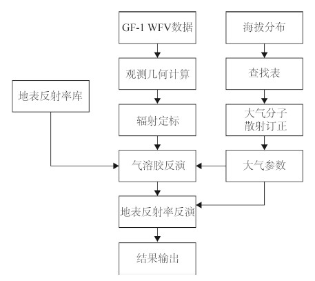
3 数据处理流程
基于上述模型与算法,本文利用IDL语言实现了GF-1星WFV数据的快速大气校正,流程图如图 1所示,主要包括5个步骤。

3.1 辐射定标
GF-1星的WFV相机辐射定标工作由中国资源卫星应用中心承担,每年会定期发布一次辐射定标结果。而研究表明(Staylor,1990),卫星传感器会随着使用时间的增长而慢慢衰减,每年对辐射定标系数进行更新不能完全满足定量遥感的需要。本文收集了2013年9月—2014年7月的WFV相机及同期过境的Landsat 8相机数据,采用敦煌稳定沙漠场的多时相定标方法,考虑到Landsat 8与GF-1星传感器波段响应函数的不同,实现GF-1卫星WFV相机的时间序列相对辐射定标,获得分季节的定标系数。具体原理与方法详见参考文献(李小英,2005)。
获取定标系数Gain后,利用式(2)将DN值转换为表观反射率ρTOA:
| ${\rho _{{\rm{TOA}}}}=\frac{{\pi({\rm{DN*Gain}})}}{{{d^{\rm{2}}}{F_0}{\rm{cos}}{\theta _{\rm{s}}}}}$ | (2) |
式中,d为卫星过境时日地距离和平均日地距离的比值,F0为大气层外太阳辐照度。
3.2 观测几何计算
GF-1星WFV相机每景图像的数据包括4个文件:(1) tiff文件,存储图像数据,格式为32位整型;(2) jpg文件,图像缩略图;(3) xml文件,数据描述文件;(4) rpb文件,图像几何定位信息。其中,xml文件仅提供图像中心点的太阳天顶角(xml文件中提供的天顶角实为高度角,还需进行处理以获得所需天顶角)、太阳方位角、观测天顶角、观测方位角等观测几何。而对于WFV等宽幅相机,图像边缘像元与中心点像元的观测几何角度差异,会对定量应用带来较大误差,还需计算每个像元的观测几何角度。
太阳天顶角根据卫星过境时间及对应像元的经纬度(可由图像4个角点经纬度双线性插值获得)按下式计算(Jacobson,2005):
| ${\rm{cos}}{\theta _{\rm{s}}}={\rm{sin(}}lat{\rm{)sin}}\delta+{\rm{cos}}(lat{\rm{)}}\cos \delta \cos t$ | (3) |
式中,lat为像元的纬度,δ表示太阳赤纬,t表示太阳时角。
观测天顶角则根据相机视场角插值获得。考虑到方位角对定量应用影响不大,整景采用统一值。
3.3 大气分子散射的海拔订正
在可见光波段,大气分子以瑞利散射的形式散射入射太阳光和地表反射光,对遥感图像的影响不可忽略。瑞利散射强度会随波长变短而迅速增强,大气分子会对波长较短的波段(蓝波段)产生强烈的散射,对遥感图像产生了较大的影响。随着海拔的增高,大气分子光学厚度逐渐降低,其散射也逐渐减小。海拔为Z时,大气分子在波长为λ的波段光学厚度可以用式(4)表示(Levy等,2007):
| ${\tau _{\lambda,{\mkern 1mu} {\rm{Z}}}}=0.00877{\lambda ^{ - 4.05}}\exp \left({\frac{{ - Z}}{{8.5}}} \right)$ | (4) |
为校正海拔对大气分子散射的影响,利用海拔在0 km、1 km、2 km、3 km、4 km、5 km时的查找表,根据每个像元的海拔插值相应的大气参数,从而准确获得该海拔下的大气分子散射(图 2)。

3.4 气溶胶反演
与大气分子相比,陆地上空的气溶胶时空分布差异较大,如何获得整景图像的气溶胶信息对大气校正至关重要。本文采用深蓝算法利用大气信号在蓝波段较强,将清晰天的地表反射率代入式(1)反演气溶胶,能够在植被、裸土、城市等大部分地表适用(Hsu等,2004,2006;王中挺等,2012)。具体反演步骤如下:
(1) 数据预处理。将GF-1 WFV数据重采样为1 km,计算各像元的太阳天顶角、观测天顶角等参数,利用相对辐射定标系数完成辐射校正,获取各波段的表观反射率。
(2) 获取地表反射率。收集往年同期的MODIS MOD09产品,提取第3波段的地表反射率数据,完成经纬度匹配获取GF-1 WFV数据各像元蓝波段的地表反射率。
(3) 反演单像元气溶胶。提取各像元海拔高度,校正大气分子散射,得到该海拔下查找表;完成角度插值,得到卫星观测几何下每个气溶胶光学厚度下(0—2)的大气参数;利用获取的各像元蓝波段地表反射率,使用查找表插值得到各像元气溶胶光学厚度。
(4) 10 km气溶胶结果合成。将得到的各像元气溶胶光学厚度划分为10×10 km的窗口,剔除云和无效像元,利用冒泡法排序窗口内的气溶胶光学厚度,剔除最高和最低的20%,将剩余像元的值平均得到该窗口的气溶胶光学厚度。
3.5 地表反射率反演
在获得10 km分辨率的气溶胶参数后,按照以下3个步骤得到WFV数据的地表反射率,完成大气校正:
(1) 大气参数的获取。根据所得的气溶胶及海拔信息,插值大气参数查找表得到各10×10 km窗口中心点在WFV相机4个波段的大气参数;通过双线性插值的方法,插值得到每个像元的大气参数。
(2) 地表反射率反演。逐波段将获得的大气参数和WFV相机的表观反射率数据代入式(1)进行矩阵运算,完成大气校正,得到相应的地表反射率。
(3) 结果存储。为节约存储空间,将反演得到WFV相机4个波段的地表反射率数据乘以1000后取整,将数据类型从64位浮点型转换为32位整型,然后统一存储在一个tif文件中。
4 结果与分析
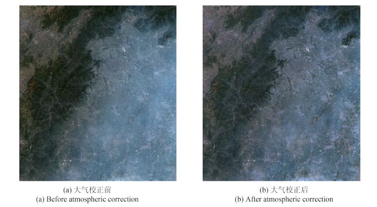
选用2013年9月27日、2015年3月13日和2015年5月25日过境华北地区的GF-1星WFV相机的3景数据分别进行了算法试验。图 3—图 5为这3景图像大气校正前后的真彩色合成图对比结果。从图中可以看出,本算法较好的去除了大气影响,尤其是大气气溶胶散射影响,提升了图像的清晰度。但在图 3图像中部、图 4下部气溶胶较厚的区域,未完全去除较厚气溶胶散射的影响。


在3景图像上分别选取了植被、城市广场、裸土3种典型地物,并计算其NDVI,以定量比较大气校正前后的结果。如表 1所示,本算法较好的去除了大气的影响,使各地物的地表反射接近真实地表反射,从而使各地物的NDVI均有所增加;在蓝、绿、红波段,消除了大气散射光入射对地表反射的增强;而在近红外波段,则校正了大气对高地表反射的削弱。
表 1 典型地物大气校正前后反射率对比表
Table 1 The apparent and correction reflectance of typical land surface
| 植被 | 城市 | 裸土 | ||||||||
| 图 1 | 图 2 | 图 3 | 图 1 | 图 2 | 图 3 | 图 1 | 图 2 | 图 3 | ||
| 校正前 | 蓝波段 | 0.101 | 0.098 | 0.156 | 0.170 | 0.168 | 0.222 | 0.166 | 0.191 | 0.158 |
| 绿波段 | 0.085 | 0.090 | 0.132 | 0.157 | 0.143 | 0.194 | 0.156 | 0.160 | 0.139 | |
| 红波段 | 0.061 | 0.057 | 0.112 | 0.155 | 0.128 | 0.181 | 0.168 | 0.153 | 0.124 | |
| 近红外波段 | 0.246 | 0.328 | 0.291 | 0.176 | 0.163 | 0.202 | 0.234 | 0.191 | 0.201 | |
| NDVI | 0.603 | 0.704 | 0.444 | 0.063 | 0.123 | 0.053 | 0.164 | 0.111 | 0.237 | |
| 校正后 | 蓝波段 | 0.015 | 0.029 | 0.084 | 0.076 | 0.091 | 0.167 | 0.101 | 0.121 | 0.049 |
| 绿波段 | 0.034 | 0.050 | 0.089 | 0.105 | 0.092 | 0.158 | 0.119 | 0.112 | 0.071 | |
| 红波段 | 0.031 | 0.033 | 0.086 | 0.134 | 0.097 | 0.169 | 0.155 | 0.131 | 0.085 | |
| 近红外波段 | 0.257 | 0.335 | 0.323 | 0.188 | 0.166 | 0.242 | 0.247 | 0.212 | 0.223 | |
| NDVI | 0.785 | 0.822 | 0.582 | 0.168 | 0.262 | 0.177 | 0.229 | 0.236 | 0.448 | |
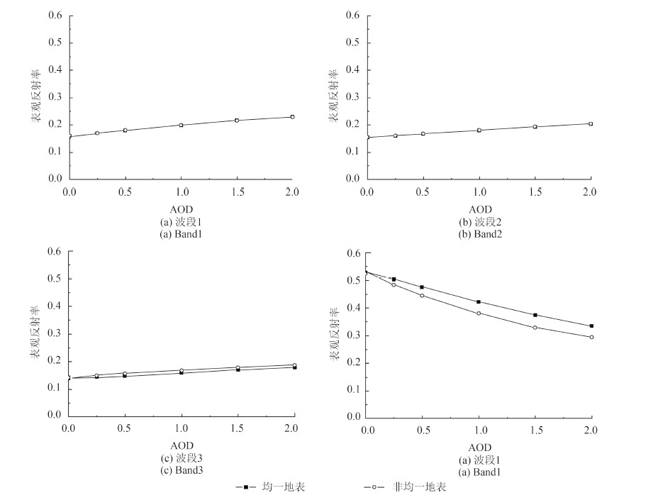
5 邻近效应影响分析
在空间分辨率较高时,卫星观测信号还会受到相邻像元的辐射影响,称为邻近效应(Singh,1988)。研究表明(Lyapustin和Kaufman,2001),当卫星数据空间分辨率小于1 km时,大气校正就必须考虑邻近效应的影响。本文采用的辐射传输模式6S在辐射传输计算中,利用环境函数计算并校正邻近效应(Vermote等,1997)。但6S在邻近效应计算中,需要预先知道目标像元及其背景区域的地表类型。本文在计算大气参数时,将地表设定为均一地表,没有考虑地表背景不同时邻近效应的影响。图 6模拟了植被像元在均一地表(植被背景)与非均一地表(裸土背景)下GF-1卫星WFV相机的表观反射率。可以看出,在蓝波段、绿波段,由于地表反射较小且植被与裸土的地表反射差异较小,目标像元与背景像元不同带来的邻近效应较小;随着波长的增加,植被与裸土的地表反射差异逐渐增大,在红波段,背景不同使表观反射率有所差异;在近红外波段,背景不同使表观反射率差异明显,且随着气溶胶光学厚度的增大而增大。
6 结论
针对GF-1 WFV相机16 m数据高分辨率、宽幅宽、大数据量等特点,利用深蓝算法获取气溶胶信息以校正其对图像的影响,建立了通用于植被、裸土等典型地表的快速大气校正算法,为GF-1 WFV数据的定量化应用提供了数据基础。并给出如下结论:
(1) 由于GF-1 WFV相机的幅宽较宽,同景图像内海拔变化可能会较大,进而影响分子散射,本算法根据每个像元的海拔校正了不同海拔大气分子散射的影响。
(2) 利用深蓝算法从GF-1 WFV相机数据同步反演气溶胶的空间分布,为整景图像的大气校正提供了必备的辅助数据。
(3) 选取过境华北地区的3景数据完成了算法试验,结果表明,本算法较好地去除了大气分子和气溶胶对图像信号的影响,但在气溶胶光学厚度较大时,校正效果不明显。
(4) 通过典型地表类型校正前后比较表明,本算法较好的还原了植被、土壤、广场等地表类型的光谱曲线,校正了大气对地表NDVI的降低。
本算法除了应用于华北地区外,还需扩展其应用范围,针对华北地区经常出现的灰霾、沙尘等高气溶胶浓度情况,还需提高大气校正效果;其次,本算法为简化流程,仅考虑均一地表,但实际存在的非均一地表会带来邻近效应的差异,这种差异在近红外波段最为明显,需在下一步工作中解决。
志谢:本文的地表反射率由NASA的MODIS MOD09产品得到,6S反演程序由E.F.Vermote提供,在此表示感谢。
参考文献(References)
-
Bai Z G.2013.Gaofen Yihao Weixing de Jishutedian. Aerospace China, (8) : 5–9 . ( 白照广. 2013. 高分一号卫星的技术特点. 中国航天, (8) : 5–9. )
-
Wen Q, Ma J W, Chen X, Li L W.2007.Correction with ground measurement data for adjacency effect in remote sensing images. Journal of Remote Sensing, 11 (2) : 159–165 . ( 温奇, 马建文, 陈雪, 李利伟. 2007. 遥感影像邻近效应的实测数据校正(Ⅱ). 遥感学报, 11 (2) : 159–165. )
-
Hagolle O, Dedieu G, Mougenot B, Debaecker V, Duchemin B, Meygret A.2008.Correction of aerosol effects on multi-temporal images acquired with constant viewing angles:application to Formosat-2 images. Remote Sensing of Environment, 112 (4) : 1689–1701 . [DOI:10.1016/j.rse.2007.08.016]
-
Hsu N C, Tsay S C, King M D, Herman J R.2004.Aerosol properties over bright-reflecting source region. IEEE Transactions on Geoscience and Remote Sensing, 42 (3) : 557–569 . [DOI:10.1109/TGRS.2004.824067]
-
Hsu C N, Tsay S C, King M D, Herman J R.2006.Deep blue retrievals of Asian aerosol properties during ACE-Asia. IEEE Transactions on Geoscience and Remote Sensing, 44 (11) : 3180–3195 . [DOI:10.1109/TGRS.2006.879540]
-
Jacobson M Z. 2005. Fundamentals of Atmospheric Modeling (2nd ed.). Cambridge:Cambridge University Press:317
-
Levy R C, Remer L A, Mattoo S, Vermote E F , Kaufman Y J.2007.Second-generation operational algorithm:Retrieval of aerosol properties over land from inversion of Moderate Resolution Imaging Spectroradiometer spectral reflectance. Journal of Geophysical Research:Atmosphere, 112 (13) : [DOI:10.1029/2006JD007811]
-
Li S S, Chen L F, Tao J H, Han D, Wang Z T , He B H.2011.Retrieval and Validation of the Surface Reflectance using HJ-1-CCD data. Spectroscopy and Spectral Analysis, 31 (2) : 516–520 . [DOI:10.1029/2006JD007811] ( 李莘莘, 陈良富, 陶金花, 韩冬, 王中挺, 贺宝华. 2011. 基于HJ-1-CCD数据的地表反射率反演与验证. 光谱学与光谱分析, 31 (2) : 516–520. [DOI:10.1029/2006JD007811] )
-
Li X Y. 2005. In Flight Radiometric Calibration and Pixel based Calibration for CCD Camera and WFI Imager on CBERS-02. Beijing:Institute of Remote Sensing Applications, Chinese Academy of Science
-
Lu D, Mausel P, Brondizio E, Moran E.2002.Assessment of atmospheric correction methods for Landsat TM data applicable to Amazon basin LBA research. International Journal of Remote Sensing, 23 (13) : 2651–2671 . [DOI:10.1080/01431160110109642]
-
Lyapustin A I, Kaufman Y J.2001.Role of adjacency effect in the remote sensing of aerosol. Journal of Geophysical Research-Atmospheres, 106 (D11) : 11909–11916 . [DOI:10.1029/2000JD900647]
-
Ma Y, Li Z Q, Li H, Hou W Z, Zhang Y H, Li D H, Zhang Y, Li K T, Chen C.2014.Influence of aerosol model in the atmospheric correction of satellite images——A case study over Tianjin region. Remote Sensing Technology and Application, 29 (3) : 410–418 . ( 马, 李正强, 李浩, 侯伟真, 张玉环, 李东辉, 张莹, 李凯涛, 陈澄. 2014. 卫星影像大气校正中气溶胶模型的影响分析——以天津地区为例. 遥感技术与应用, 29 (3) : 410–418. )
-
Peng G X, He Y H, Li J, Chen Y H, Lin W J.2007.Study on CBERS-2's CCD image cross calibration and atmospheric correction. Journal of Infrared and Millimeter Waves, 26 (1) : 22–25 . ( 彭光雄, 何宇华, 李京, 陈云浩, 林文娟. 2007. 中巴地球资源02星CCD图像交叉定标与大气校正研究. 红外与毫米波学报, 26 (1) : 22–25. )
-
Singh S M.1988.Estimation of multiple reflection and lowest order adjacency effects on remotely-sensed data. International Journal of Remote Sensing, 9 (9) : 1433–1450 . [DOI:10.1080/01431168808954951]
-
( StaylorW F. 1990. Degradation rates of the AVHRR visible channel for the NOAA 6, 7 and 9 spacecraft. Journal of Atmospheric and Oceanic Technology, 7 (3) : 411–423. [DOI:10.1175/1520-0426(1990)0072.0.CO;2] )
-
Sun C K, Sun L, Ma S F, Peng J J, Wang J, Wen J G, Cheng J.2012.Atmospheric correction method based on HJ-1 CCD data. Journal of Remote Sensing, 16 (4) : 826–836 . ( 孙长奎, 孙林, 麻盛芳, 彭菁菁, 王健, 闻建光, 程洁. 2012. HJ-1 CCD数据大气校正方法研究. 遥感学报, 16 (4) : 826–836. )
-
Tanré D, Herman M, Deschamps P Y, de Leffe A.1979.Atmospheric modeling for space measurements of ground reflectances, including bidirectional properties. Applied Optics, 18 (21) : 3587–3594 . [DOI:10.1364/AO.18.003587]
-
( VermoteE F, TanreD, DeuzeJ L, HermanM, Morcette J J. 1997. Second simulation of the satellite signal in the solar spectrum 6S:an overview. IEEE Transactions on Geoscience and Remote Sensing, 35 (3) : 675–686. [DOI:10.1109/36.581987] )
-
Wang Z T, Li Q, Wang Q, Li S S, Chen L F, Zhou C Y, Zhang L J, Xu Y J.2012.HJ-1 terrestrial aerosol data retrieval using deep blue algorithm. Journal of Remote Sensing, 16 (3) : 596–610 . ( 王中挺, 厉青, 王桥, 李莘莘, 陈良富, 周春艳, 张丽娟, 徐拥军. 2012. 利用深蓝算法从HJ-1数据反演陆地气溶胶. 遥感学报, 16 (3) : 596–610. )
-
Wang Z T, Wang H M, Li Q, Zhao S H, Li S S, Chen L F.2014.A quickly atmospheric correction method for HJ-1 CCD with deep blue algorithm. Spectroscopy and Spectral Analysis, 34 (3) : 729–734 . ( 王中挺, 王红梅, 厉青, 赵少华, 李莘莘, 陈良富. 2014. 基于深蓝算法的HJ-1 CCD数据快速大气校正模型. 光谱学与光谱分析, 34 (3) : 729–734. )
-
Wen X P, Hu G D, Yang X F.2009.Simulation experiments on adjacency effect of satellite remote sensing pixels. Journal of Infrared and Millimeter Waves, 28 (1) : 46–49 . ( 温兴平, 胡光道, 杨晓峰. 2009. 卫星遥感像元邻近效应的模拟试验. 红外与毫米波学报, 28 (1) : 46–49. )
-
Yang L, Pan Z Q, Fu Q Y, Han Q J, Sun K, Zhang X W , Wang A C.2013.Research on the atmospheric correction for ZY-3 Mux image. Spectroscopy and Spectral Analysis, 33 (7) : 1903–1907 . ( 杨磊, 潘志强 , 傅俏燕, 韩启金, 孙珂, 张学文, 王爱春. 2013. 资源三号卫星多光谱数据的大气校正研究. 光谱学与光谱分析, 33 (7) : 1903–1907. )
-
Zeng Q, Zhao Y, Tian L Q, Chen X L.2013.Evaluation on the atmospheric correction methods for water color remote sensing by using HJ-1A/1B CCD image-taking Poyang Lake in China as a case. Spectroscopy and Spectral Analysis, 33 (5) : 1320–1326 . ( 曾群, 赵越, 田礼乔, 陈晓玲. 2013. HJ-1A/1B卫星CCD影像水环境遥感大气校正方法评价研究——以鄱阳湖为例. 光谱学与光谱分析, 33 (5) : 1320–1326. )
-
Zhao X, Liang S L, Liu S H, Wang J D, Qin J, Li Q, Li X W.2008.Improvement of dark object method in atmospheric correction of hyperspectral remotely sensed data. Science in China Series D:Earth Sciences, 51 (3) : 349–356 . [DOI:10.1007/s11430-007-0149-y]
-
Zheng S, Zhao X, Zhang H, He Q S, Cao C X, Chen L F.2011.Atmospheric correction on CCD data of HJ-1 satellite and analysis of its effect. Journal of Remote Sensing, 15 (4) : 709–721 . ( 郑盛, 赵祥, 张颢, 何祺胜, 曹春香, 陈良富. 2011. HJ-1卫星CCD数据的大气校正及其效果分析. 遥感学报, 15 (4) : 709–721. )


