2. Department of Geophysics, Tohoku University, Sendai 980-8578;
3. 中国科学院广州地球化学研究所, 同位素地球化学国家重点实验室, 广州 510640;
4. 中国地震局地质研究所, 北京 100029
2. Department of Geophysics, Tohoku University, Sendai 980-8578, Japan;
3. State Key Laboratory of Isotope Geochemistry, Guangzhou Institute of Geochemistry, Chinese Academy of Sciences, Guangzhou 510640, China;
4. Institute of Geology, CEA, Beijing 100029, China
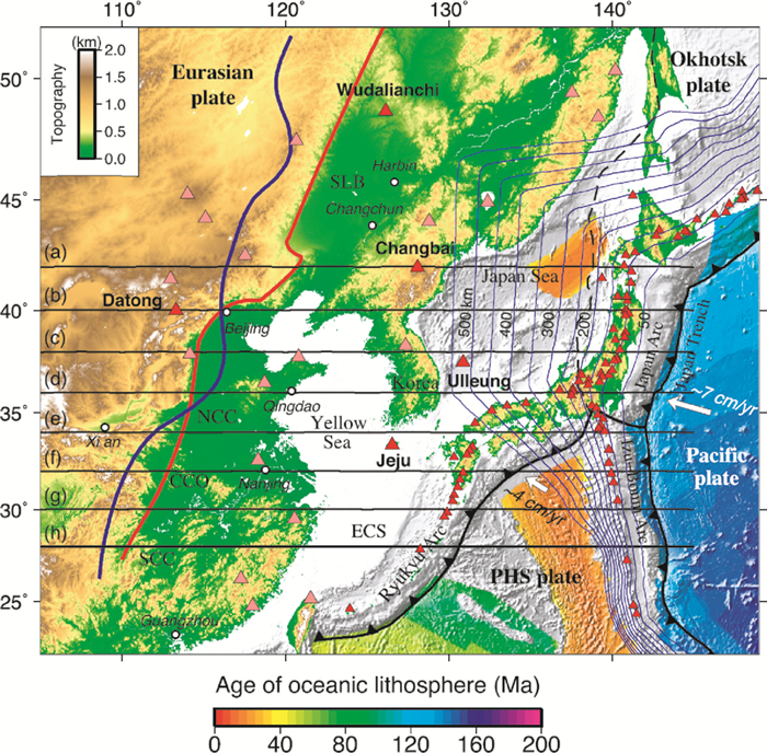
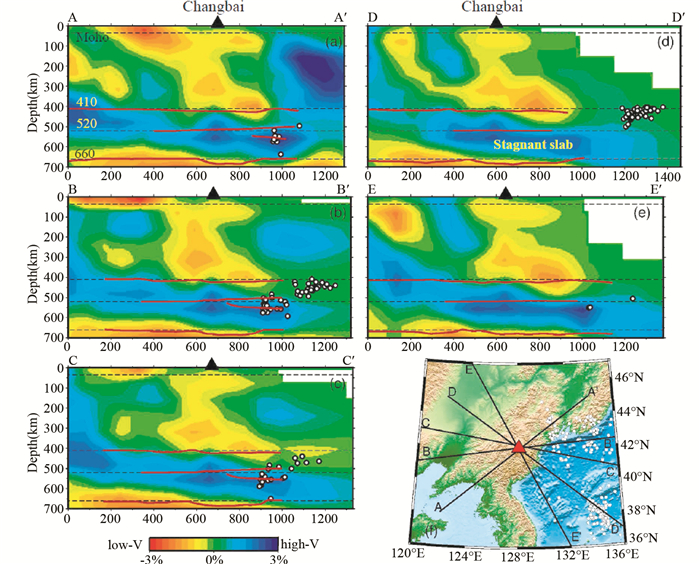
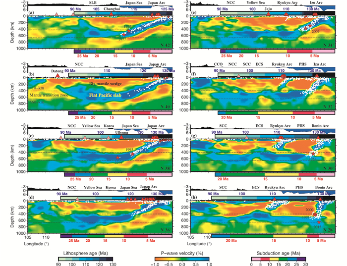
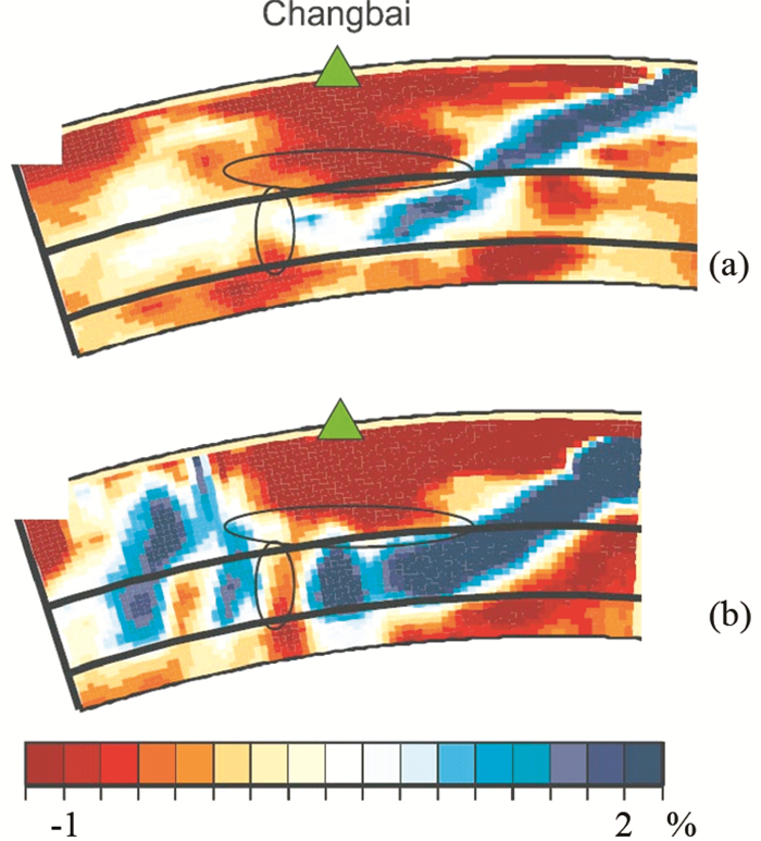
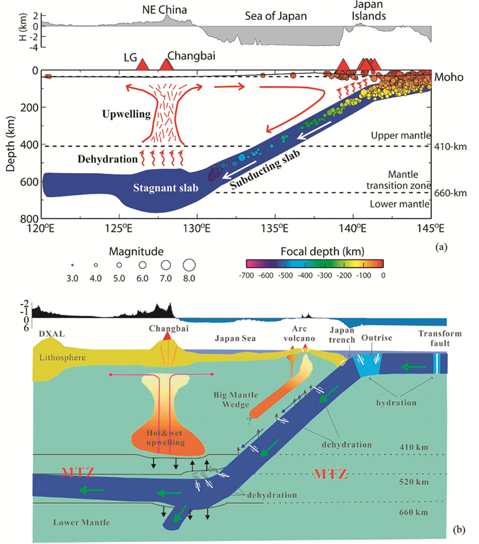
长白山火山位于中朝边界,是我国保存最完好的新生代火山(图 1)。在长白山周围分布着100多座小火山,构成一个火山群,其中天池火山是最大的一个火山,火山海拔约2600m左右,天池直径约4.5km,水深达800多米,呈漏斗状盆型,约有20.4亿立方米存水(刘嘉麒, 1999; 刘若新, 2000)。天池火山在全新世时期有过多次大规模爆破性喷发,最大的一次喷发在约1000年前,喷出了约30~40km3的岩浆(魏海泉, 2014),在此之后还相继发生过1668年、1702年和1903年等多期中小规模喷发活动(金东淳和崔钟燮, 1999),目前仍然是一座具有高度危险性的火山(刘若新等, 1992;刘若新,2000; 刘嘉麒, 1999)。岩石地球化学研究结果表明,长白山火山下方存在地壳和地幔双层岩浆房,且地幔玄武岩浆注入地壳岩浆房触发了千年大喷发(刘若新等, 1998; 樊祺诚等, 2005)。全球地震层析成像(Zhou and Clayton, 1990; van der Hilst et al., 1991; Fukao et al., 1992; Bijwaard et al., 1998; Zhao, 2004; Lei and Zhao, 2006)和大尺度绝对走时区域层析成像结果(Huang and Zhao, 2006; Wei et al., 2012, 2015; Li and van der Hilst, 2010; Chen et al., 2015, 2017)显示,长白山火山下方的地幔转换带中存在明显连续的高波速异常,普遍将该高波速异常解释为滞留在地幔转换带中的俯冲太平洋板块,进而认为长白山火山的深部起源与太平洋板块深俯冲形成的“大地幔楔”(Big Mantle Wedge, BMW)结构动力学有关(图 2、图 3)。但是,一个新近的远震相对走时成像结果(Tang et al., 2014),则显示长白山下的地幔转换带中存在一个低波速异常区,并将该低波速异常解释为俯冲的太平洋板块在地幔转换带中的“空缺”(gap),进而认为长白山火山的深部成因与地幔热柱由下地幔穿过此“空缺”而进入上地幔有关(图 4b)。因此,目前关于长白山火山下的地幔岩浆起源问题,还存在很大的争议。由于噪音成像和天然地震面波成像技术难以获得地幔转换带深度的成像结果,而全球体波成像或近震、远震体波区域尺度成像技术则可获得深至地幔转换带的成像结果,因此本文主要回顾一下长白山火山区下方深部结构特别是地幔转换带中的体波成像结果,讨论结果异同性的原因,并结合接收函数结果、高温高压实验、数值模拟和岩石地球化学研究结果,从而更好地认识长白山火山的岩浆起源和深部动力学过程。
|
图 1 东北亚构造环境(据Liu et al., 2017) 红色三角形代表活动火山; 品红三角形代表中生代玄武岩位置; 蓝色细线代表由地震活动性得到的俯冲太平洋板块上界面等深线; 红色粗线显示了南北重力梯度带(NSGL); 蓝色粗线显示了由图 3所示成像结果估计的地幔转换带中的展平太平洋板块西边界; 8条黑线代表了图 3所示纵剖面位置.锯齿状实线代表板块边界.SLB-松辽盆地;NCC-华北克拉通;CCO-中部造山带;SCC-华南克拉通;ECS-东海;PHS-菲律宾海 Fig. 1 Tectonic settings of NE Asia (after Liu et al., 2017) The red triangles denote active volcanoes; the pink triangles denote locations of the Cenozoic basalts; the thin blue lines denote depth contours of the upper boundary of the subducting Pacific slab estimated from seismicity; the thick red line shows the North-South Gravity Lineament (NSGL); the thick blue line shows the western edge of the flat Pacific slab in the mantle transition zone (MTZ) estimated from the tomographic model shown in Fig. 3; the eight black lines denote locations of the vertical cross-sections shown in Fig. 3. The solid sawtooth lines denote the plate boundaries. SLB-the Songliao Basin; NCC-the North China Craton; CCO-the Central China Orogen; SCC-the South China Craton; ECS-the East China Sea; PHS-the Philippine Sea |
|
图 2 穿过长白山火山(三角形)的P波近震层析成像(a-e, 据Zhao et al., 2009; Zhao and Tian, 2013) 5个纵剖面图及纵剖面位置(f) 蓝色和红色分别代表高、低波速,其色标示于图底;白色圆圈为深源地震;虚线分别代表莫霍面、410km、520km和660km间断面(d410、d520和d660);红色实线代表Tian et al. (2016)利用接收函数估计的d410、d520和d660间断面.需要注意的是,所有深源地震应发生在俯冲的太平洋板块内,但由于日本海地区无地震台站的原因使得震源深度存在较大不确定性 Fig. 2 Vertical cross-sections of P-wave local tomography (a-e, after Zhao et al., 2009; Zhao and Tian, 2013) along the five profiles shown in the inset map (f) which pass through the Changbaishan intraplate volcano (the triangles) The blue and red colors denote high and low velocities, respectively, whose scale (in %) is shown at the bottom. The white dots denote deep earthquakes. The dashed lines denote the Moho, 410km, 520km and 660km discontinuities (d410, d520 and d660). The red lines show the estimated depths of d410, d520 and d660 using teleseismic receiver functions (Tian et al., 2016). Note that all the deep earthquakes should have occurred within the subducting Pacific slab, but their focal depths have large uncertainties because there is no seismic station in the Japan Sea |
|
图 3 P波区域成像结果的如图 1所示8个纵剖面图(据Liu et al., 2017) 红色和蓝色分别代表低、高波速,其色标位于底部中间.纵剖面上方带有蓝色数字的颜色条显示由西(中国东部)向东(近日本海沟)岩石圈的俯冲年龄,其色标(单位Ma)位于图底左侧.沿剖面的地表地形示于岩石圈年龄条之上.剖面之下带红色数字的颜色条显示太平洋板块的俯冲年龄,其色标(单位Ma)位于图底右侧; 剖面上部的红色和品红色三角形分别代表距离剖面1°范围内的活动火山和新生代玄武岩.距离剖面1°范围内的背景地震和大地震(M≥7.0)分别显示为白色圈圈和红色星号; 两个黑色虚线分别代表 410km和660km间断面 Fig. 3 Vertical cross-sections of P-wave regional tomography along the eight profiles shown in Fig. 1 (after Liu et al., 2017) The red and blue colors denote low and high velocity perturbations, respectively, whose scale (in %) is shown at the bottom-middle. The color bar with blue numbers above each cross-section shows the subducting Pacific lithosphere ages from the west (East China) to the east (near the Japan Trench), whose scale (in Ma) is shown at the bottom-left. The surface topography along each profile is shown above the lithosphere age bar. The color bar with red numbers below each cross-section shows the subduction ages of the Pacific slab, whose scale (in Ma) is shown at the bottom-right. The red and pink triangles atop each cross-section denote locations of active volcanoes and Cenozoic basalts, respectively, within a 1° width of each profile. The background seismicity and large earthquakes (M≥7.0) that occurred within a 1° width of each profile are shown in white circles and red stars, respectively. The two black dashed lines denote the 410km and 660km discontinuities |
|
图 4 沿着穿过长白山火山东西向纵剖面的两个层析成像模型的对比图 红色和蓝色分别代表低波速和高波速,其色标(%)显示于图底; 绿色三角形代表长白山火山.(a)通过反演西太平洋和东北亚区域地震穿过地幔转换带的三重震相绝对走时残差获得的成像结果(Takeuchi et al., 2014);(b)通过反演远震事件相对走时残差获得的成像结果(Tang et al., 2014) Fig. 4 Comparison of two tomographic models along an east-west vertical cross-section passing through the Changbaishan volcano The red and blue colors denote low and high velocities, respectively, whose scale (in %) is shown at the bottom. The green triangle denotes the Changbaishan volcano. (a) an image obtained by inverting absolute travel-time residuals of triplicated phases across the mantle transition zone from regional earthquakes in Western Pacific and NE Asia (Takeuchi et al., 2014); (b) an image obtained by inverting relative travel-time residuals of teleseismic events (Tang et al., 2014) |
地震层析成像技术是由医学上CT成像技术演变过来的。CT成像技术是通过仪器的旋转获得交叉性X射线,从而获得身体病变的位置和大小。地震层析成像则是由地下发生的地震由地表地震台站所接收的地震波在地球内部形成较好的射线交叉,从而获得地球内部的三维地震波速度结构。地震层析成像开始于二十世纪七十年代中期(Aki and Lee, 1976)。根据研究尺度和所用资料可将地震层析成像分为三类:一类是近震层析成像,第二类是远震层析成像,第三类是全球层析成像。近震层析成像(Aki and Lee, 1976; Zhao et al., 1992)主要是利用研究区内的地震台站记录到的研究区内地震事件的到时进行成像,一般采用地震波的绝对走时数据,计算观测走时与理论走时之差(即走时残差),从而获得地震波绝对速度分布。远震成像技术(Aki et al., 1977;Zhao et al., 1994)主要利用研究区内的地震台站记录到研究区外的远震事件到时资料进行成像。远震事件一般是指震中距在30°~90°之间的地震事件,这类成像技术使用的是地震波的相对走时残差资料,即研究区内的每个地震台站记录到的绝对走时残差减去研究区内所有台站的绝对走时残差的平均值。因此,远震成像技术获得的结果为相对速度分布。全球成像技术,顾名思义,即是利用全球范围内的地震台站记录到的全球范围内的地震事件到时资料开展的成像,获得的成像结果为绝对速度分布。针对长白山火山区深部成像结果,目前既有远震成像结果(Lei and Zhao, 2005; Duan et al., 2009; Tang et al., 2014),也有近震和远震联合成像结果(Zhao et al., 2009; Chen et al., 2017),还有大尺度区域和全球成像结果(Zhao, 2004; Huang and Zhao, 2006; Lei and Zhao, 2006; Li and van der Hilst, 2010)。以下,我们分别介绍由这些成像技术获得的成像结果,深入地认识长白山火山下方的上地幔及地幔转换带的深部结构,从而弄清长白山火山的深部起源等动力学问题。
2 体波地震层析成像结果长白山火山位于我国东北吉林省与朝鲜交界处,距离太平洋板块开始俯冲的日本海沟约1200km (图 1)。全球成像结果(van der Hilst et al., 1991; Fukao et al., 1992; Bijwaard et al., 1998; Zhao, 2004; Lei and Zhao, 2006)显示,长白山火山下方的上地幔内存在明显的低波速异常,而地幔转换带中存在明显的连续高波速异常,说明太平洋板块已经俯冲到我国东北地区长白山火山区下方。然而,由于全球成像模型较为粗糙,其模型空间分辨率约300~500km,难以提供长白山火山深部的详细结构特征。为此,Lei and Zhao (2005)利用中国地震局地球物理勘探中心与美国纽约州立大学合作于1998年6月至1999年4月期间在长白山火山区布设的19个流动地震台站记录到的远震到时资料,首次开展了该区的远震层析成像,获得的结果显示出长白山火山下方深至400km存在明显的柱状低波速异常,而在地幔转换带中存在明显的高波速异常,且高波速异常附近发生有深源地震。这一结果表明,地幔转换带中的高波速异常代表俯冲的太平洋板块,而上地幔中的柱状低波速异常可能代表了由于板块深俯冲滞留脱水而造成的热物质上涌(Lei and Zhao, 2005)。结合全球及东亚区域成像结果(Zhao, 2004; Lei and Zhao, 2006; Huang and Zhao, 2006),我们提出,这种太平洋板块深俯冲至地幔转换带在东亚地区形成了“大地幔楔(Big Mantle Wedge, BMW)”(图 5) (Zhao, 2004; Lei and Zhao, 2005; Zhao et al., 2007; Lei et al., 2013)。这个“大地幔楔”模型对于理解长白山等东亚地区板内火山的深部起源及地幔动力学过程有很重要的意义。随后,通过增加中国区域地震台站资料(Zhao et al., 2009)和增加流动地震观测资料(Duan et al., 2009)的方式,继续改进成像结果,与Lei and Zhao (2005)模型相比,新的成像结果(Zhao et al., 2009; Duan et al., 2009)显示,尽管在波速异常细节上存在差别,但波速异常的模式基本没有改变,即长白山火山下方的上地幔为明显低波速异常,而地幔转换带中存在明显高波速异常(图 2)。大尺度区域地震层析成像结果(Huang and Zhao, 2006; Li and van der Hilst, 2010; Wei et al., 2012, 2015),也都支持“大地幔楔”模型(图 3)。
|
图 5 基于早期地震层析成像结果(据Zhao, 2004; Lei and Zhao, 2005; Huang and Zhao, 2006; Zhao et al., 2007, 2009)提出的“大地幔楔(BMW)”模型卡通示意图 (a)采用了Lei et al. (2013)模型;(b)采用了Zhao and Tian (2013)和Tian et al. (2016)模型.该“大地幔楔”模型强调了“大地幔楔”中的低波速异常、地慢转换带的间断面深度变化、太平洋板块内的深源大地震及长白山板内火山作用之间的密切关系.在地幔转换带中,图 5b中的实线代表了Tian et al. (2016)由接收函数估计的410km、520km和660km间断面,而虚线显示了相应间断面全球平均.LG-龙岗活动火山 Fig. 5 Cartoons showing the big mantle wedge (BMW) model which was proposed based on the early tomographic results of NE Asia (after Zhao, 2004; Lei and Zhao, 2005; Huang and Zhao, 2006; Zhao et al., 2007, 2009) (a) adopted from Lei et al. (2013); (b) adopted from Zhao and Tian (2013) and Tian et al. (2016). This BMW model emphasizes the close relationship among the low-velocity anomalies in the BMW, depth variations of the mantle transition zone (MTZ) discontinuities, large deep earthquakes in the Pacific slab, and the Changbaishan intraplate volcanism. In the MTZ, the solid lines in Fig. 5b represent the 410km, 520km and 660km discontinuities estimated by a receiver-function study (Tian et al., 2016), whereas the dashed lines show the global averages of the corresponding discontinuities. LG-the Longgang active volcano |
Zhao and Tian (2013)进一步提出,在长白山火山的东北方向约200~300km的珲春地区下方频繁发生的超深大地震(深度>500km; M>7.0)和长白山火山的起源有关。这些超深大震有可能释放出俯冲太平洋板块中的流体,有助于在“大地幔楔”内形成更多的岩浆提供给长白山火山,从而使得该火山成为东亚地区最大和最活动的板内火山(图 5b)。
随着中日美国际合作在中国东北地区开展流动地震观测,即地震台网NECESSArray,弥补了东北地区省级固定地震台站稀疏的不足。通过固定地震台站联合流动地震台站资料,使用有限频远震地震层析成像技术(Hung et al., 2004),Tang et al. (2014)获得了一个与前人不同的成像结果。该成像结果显示,长白山火山下方的低波速异常可延深至下地幔,即在地幔转换带中高波速异常所代表的太平洋板块内存在一个低波速异常指示的“空缺”(图 4b)。根据这个成像结果,作者认为由于太平洋板块后撤、板块下方的低波速异常由地幔转换带中俯冲太平洋板块的“空缺”上升至上地幔,从而形成长白山火山。这一解释与前述的“大地幔楔”模型明显不同。深源地震研究结果表明,俯冲板块触碰660km间断面后可能有与下插板块主体的断离,因而可能形成软弱区及进一步的低速,可能形成下地幔物质上涌的通道(Yu et al., 2016)。这一结果似乎支持Tang et al. (2014)结果,且Tang et al. (2014)利用波形拟合的方法还对低波速异常指示的“空缺”进行了论证,但波形模拟可能受更多因素影响,如地震震源机制、衰减、间断面(如莫霍面、康拉德)和岩浆房等。
为证实地幔转换带中高波速异常所代表的俯冲太平洋板块是否存在“空缺”和下地幔热物质上涌,Takeuchi et al. (2014)利用NECESSArray台阵和日本岛弧密集宽频带F-net台网记录到的三重震相(Triplicated phases)的到时资料,开展了西北太平洋地区地震层析成像研究,其结果显示,长白山火山下方深至410km间断面之上的低波速异常相对于不用三重震相资料的结果更为明显,但地幔转换带中代表俯冲太平洋板块的高波速异常并未出现“空缺”(图 4a),因此该结果并不支持板块“空缺”模型,反而支持“大地幔楔”模型。有关细节,请参阅Takeuchi et al.(2014)。
Wei et al. (2015)利用国际地震中心(ISC)观测报告资料以及中国与日本区域台网地震到时资料,开展了西北太平洋俯冲带地区深至800km的P波和S波速度结构成像,尽管无论是P波还是S波在长白山火山下方的地幔转换带中的波速略比其他区域略低一些,但还是显示出明显高波速异常而非低波速异常,说明地幔转换带中的俯冲太平洋板块内并无“空缺”(图 3)。
最近,为进一步解决这一争议,Chen et al. (2017)利用中国东北区域台网资料、NECESSArray台网资料、韩国地震台网资料和日本列岛台网地震资料,分别从仅用远震相对到时资料、仅用近震绝对到时资料、联合近震与远震到时资料的角度详细地研究了西北太平洋地区深至地幔转换带深部细结构。结果非常清晰地显示,如果仅用远震相对到时资料,长白山火山区下方的地幔转换带无论是P波还是S波的确存在所谓的“低波速异常”;如果仅用近震绝对到时资料,长白山火山区下方的地幔转换带中P波和S波均为明显的连续的高波速异常,即不存在远震相对到时成像结果显示的低波速异常指示的“空缺”;如果将远震相对到时资料与近震绝对到时资料联合反演成像,则在长白山火山区下方的地幔转换带内P波和S波均相对于其他地区略低些,但还显示的是连续高波速异常。这些结果表明,在利用远震成像研究地幔转换带中波速异常结构时,由于所使用的是相对到时资料,因而只能给出模型的相对速度、而难以给出模型的绝对速度值。因此,在未来远震成像工作中,建议增加深至地幔转换带的近震绝对走时资料,以更好约束地幔转换带深度的成像结果。有关细节,请参阅Chen et al. (2017)。
3 讨论以上主要展示了近年来我国东北地区体波走时成像结果,探讨了由于资料类型和成像技术的不同而导致成像结果的差异性,认为更多证据并不支持长白山火山下方地幔转换带中俯冲太平洋板块存在“空缺”。以下,我们利用接收函数、高温高压实验、数值模拟和岩石地球化学研究结果,进一步探讨长白山火山下方地幔转换带中俯冲太平洋板块是否存在下地幔热物质上涌“空缺”,以深入理解长白山火山深部起源科学问题。
3.1 接收函数研究结果地幔转换带的上界面410km间断面和下界面660km间断面,被认为是橄榄石相变到瓦兹利岩(wadsleyite) (Katsura and Ito, 1989)、尖晶橄榄石或林伍德石(ringwoodite)相变到钙钛矿(perovskite)+镁方铁矿(magnesiowüstite) (Ito and Takahashi, 1989)的温度敏感间断面。由于410km间断面有着克拉珀龙正斜率、而660km间断面有着克拉珀龙负斜率,因此如果地幔转换带的温度增加(或降低),则会导致410km间断面沉降(或抬升)和660km间断面抬升(或沉降),分别对应着热物质上涌(如地幔柱)穿过地幔转换带或冷物质(如俯冲板块)进入地幔转换带(Helffrich, 2000; Deuss et al., 2006; Deuss, 2007)。
目前,用于研究410km和660km间断面深度的地震学方法较多,如远震转换波接收函数方法、SS前驱波、ScS回响波和三重震相法等,地震学者利用这些方法在我国东北地区已获得很多有意义的研究结果。利用SS前驱波资料获得的西北太平洋俯冲带下方的地幔转换带结果显示,我国东北地区660km间断面可深至670~680km、地幔转换带厚度可达250~260km (Flanagan and Shearer, 1998),表明太平洋板块已俯冲至我国东北地区地幔转换带深度。然而,尽管SS前驱波资料覆盖范围较广,但研究结果的空间分辨率较低。为此,Ai et al. (2003)和Li and Yuan (2003)使用长白山火山区流动与省级区域地震台站资料,开展了远震转换波接收函数成像研究,获得的结果展示出660km间断面存在明显局部下沉现象,地幔转换带增厚至20~35km,作者将其解释为660km间断面被俯冲太平洋板块下塌分裂为多个间断面或由于相变导致的高密度物质而引起重力失衡穿透至下地幔。这些结果说明,太平洋板块已俯冲至我国东北长白山火山下方的地幔转换带中并存在滞留现象。P波和SH波三重震相波形拟合结果暗示,在中国东北地区的地幔转换带中存在有俯冲的太平洋板块(Tajima and Grand, 1998),其厚度约140km厚,并推测在此板块上界面有水存在(Li et al., 2013)。Wang et al. (2017)利用ScS回响波共反射点叠加技术,认为长白山火山区附近660km间断面明显加深、410km间断面部分抬升,说明太平洋板块已俯冲至长白山火山下方且410km间断面处有热湿物质上涌。由于这些研究所用资料在空间上的局限性,获得结果对于理解长白山火山深部起源受到一定限制。
随着NECESSArray台网资料的公开,我国东北地区410km和660km间断面埋深细结构的研究也随之展开,这些研究结果(Liu et al., 2015; Zhang et al., 2016)展示出相类似的结构特征,即长白山火山以西地区存在地幔转换带变薄而以东地区存在明显加厚现象,推测长白山火山的形成可能与板块后撤、板块下方低波速热物质由板块“空缺”上涌有关,与Tang et al. (2014)远震成像研究结果相类似。尽管该结果与Ai et al. (2008)在北黄海下方发现小尺度地幔转换带变薄有些类似,但所不同的是北黄海下方的地幔转换带中呈现出明显的连续高波速异常、并未出现低波速异常指示的“空缺”(Huang and Zhao, 2006)。另外,不难发现,Liu et al. (2015)和Zhang et al. (2016)在分析660km间断面接收函数研究结果时,以我国东北地区的平均值670km为基准来探讨板块是下沉或抬升等科学问题、以我国东北地区的平均厚度260km为基准来探讨地幔转换带是减薄或增厚等科学问题。如果以iasp91模型(Kennett and Engdahl, 1991)中全球平均深度值660km作为基准来探讨660km间断面是抬升或下沉、地幔转换带也以iasp91模型(Kennett and Engdahl, 1991)中全球平均厚度值250km为基准来探讨转换带增厚或减薄的话,则我们认为太平洋板块在地幔转换带中行走空间范围可能到达松辽盆地以西的重力梯度带附近(图 1),也难在长白山火山以西地区发现明显的地幔转换带变薄或“空缺”现象,这与全球和区域尺度成像结果(Zhao, 2004; Lei and Zhao, 2006; Huang and Zhao, 2006; Wei et al., 2012, 2015)相一致。Tian et al. (2016)利用松辽盆地以东地区流动地震台站和区域地震台网地震资料和转换波接收函数技术,获得长白山火山及周边地区地幔转换带结构,作者以全球平均值410km、660km与250km分别做为相应间断面埋深和转换带厚度为基准来分析间断面与转换带变化情况,结合Zhao et al. (2009)层析成像结果,认为410km间断面沉降区对应了上地幔明显低波速异常分布,660km间断面沉降区对应转换带中高波速异常分布,说明太平洋板块已俯冲至长白山火山下方并造成了滞留板块脱水和板块之上的地幔热物质上涌等动力学过程。因此,接收函数证据不支持长白山火山深部起源是由下地幔中热物质经地幔转换带中“空缺”上涌等动力学过程,而支持由太平洋板块深俯冲至地幔转换带中滞留脱水和板块之上的地幔热物质上涌等动力学过程相关的“大地幔楔”模型。
3.2 高温高压实验与数值模拟研究结果如前所述,不同尺度的地震层析成像结果和不同资料的接收函数结果均认为长白山火山的深部起源是与太平洋板块深俯冲至地幔转换带形成“大地幔楔”结构有关。这种“大地幔楔”模型(图 5)主要包含了太平洋板块的深俯冲、滞留、脱水和热物质上涌等动力学过程,其中滞留脱水导致的上地幔含水已被岩石矿物学(Shieh et al., 1998)和含水橄榄岩高温高压实验(Komabayashi et al., 2004)所证实。通过水对瓦兹利石(Wadsleyite)和林伍德石(Ringwood)电导率影响的高温高压实验研究表明,在西北太平洋俯冲带的地幔转换带中存在高达0.1%~0.2%水含量(Huang et al., 2005)。在地幔转换带中,由水而导致矿物密度降低可引起滞留板块之上的湿物质上涌(Richard and Bercovici, 2009)。数值模拟结果也证实,板块之上数十千米厚的含水层携带有大量水进入地幔转换带(Iwamori, 2004; Richard et al., 2006),且水的存在可导致瑞利-泰勒型不稳定并以相对短的时间将水传递至岩石圈底界面从而产生熔融(Richard and Iwamori, 2010)。一般地讲,年轻的暖(warm)板块仅能携带少量的水进入深部地幔,而较老的冷(cold)板块可将大量的水带入深部地幔(Poli and Schmidt, 2002)。He (2017)热模拟研究结果表明,东亚第四纪火山的形成与演化可分为以下三个阶段:第一阶段是在特定的热粘滞条件下水可由深俯冲的太平洋板块带入地幔转换带;第二阶段是周围地幔加热平俯冲板块表面可产生湿物质或脱水现象;第三阶段水散布于“大地幔楔”结构中。这些结果均说明,深俯冲至地幔转换带中的太平洋板块滞留脱水引起的热湿物质上涌对于长白山火山的形成起到了至关重要的作用(图 5)。
3.3 岩石地球化学研究结果Sr和Nd同位素地球化学研究结果显示,长白山火山各阶段火山岩具有一致的似原始地幔特征,暗示存在巨大的壳内岩浆房和持续的幔源岩浆的补给(樊祺诚等, 2001)。根据年代学和岩石学研究,樊祺诚等(2006)提出了长白山火山造盾、造锥历史和岩浆结晶分异转型的时间约束,认为早更新世开始粗面玄武岩的造盾、大约在早更新世晚期(约1Ma)粗面玄武岩向粗安岩-粗面岩演化、晚更新世(约0.1Ma)粗面岩向碱流岩演化。在中-晚更新世来自地壳岩浆房的粗面岩造锥过程中,来自地幔的粗面玄武岩喷发活动始终没有间断过。地幔粗面玄武岩质岩浆的这种不间断地向地壳岩浆房补给,可能与太平洋板块深俯冲滞留脱水和热物质上涌等动力学过程密切相关。铀钍非平衡研究结果显示,长白山火山岩显示出显著的230Th过剩,表明其岩浆主要来自于软流圈地幔而非下地幔(邹海波和樊祺诚, 2011)。采用岩石化学和同位素分析方法,马晗瑞等(2015)详细地研究了长白山火山区二道白河流域早更新世玄武岩质熔岩的成因,结果显示Nb/Ta之比为14.8~15.8,推测长白山火山玄武质岩浆的形成与太平洋板块深俯冲滞留脱水热物质上涌等动力学过程有关。这些研究结果表明,岩石地球化学证据支持长白山火山的形成是与太平洋板块深俯冲有关,并且否定下地幔热物质上涌。
4 结束语尽管利用相对走时资料的一个远震成像结果显示出长白山火山下方的地幔转换带中的俯冲太平洋板块中存在“空缺”,但利用绝对走时资料的近震成像结果却显示不出低波速异常指示的“空缺”,而是连续的高波速异常,说明长白山火山下方的地幔转换带中的俯冲太平洋板块中并不存在“空缺”。综合接收函数结果、高温高压实验、数值模拟结果和岩石地球化学研究结果,本文并不支持长白山火山以西的地幔转换带中存在“空缺”。长白山火山的深部起源与太平洋板块深俯冲形成的大地幔楔中的热湿物质上涌有关。该“大地幔楔”模型强调太平洋板块的深俯冲和在地幔转换带中滞留、脱水,从而引起板块之上的“大地幔楔”内热物质上涌,因而导致板内火山的形成等动力学过程(图 5)。
致谢 感谢评审专家评审过程中所付出的辛苦工作及所提出建设性修改意见使本文的论述和表达更为清晰、严谨。
Ai YS, Zheng TY, Xu WW, He YM and Dong D. 2003. A complex 660km discontinuity beneath Northeast China. Earth and Planetary Science Letters, 212(1-2): 63-71. DOI:10.1016/S0012-821X(03)00266-8 |
Ai YS, Zheng TY, Xu WW and Li Q. 2008. Small scale hot upwelling near the North Yellow Sea of eastern China. Geophysical Research Letters, 35(20): L20305. DOI:10.1029/2008GL035269 |
Aki K and Lee WHK. 1976. Determination of three-dimensional velocity anomalies under a seismic array using first P arrival times from local earthquakes:1. A homogeneous initial model. Journal of Geophysical Research, 81(23): 4381-4399. |
Aki K, Christoffersson A and Husebye ES. 1977. Determination of the three-dimensional seismic structure of the lithosphere. Journal of Geophysical Research, 82(2): 277-296. DOI:10.1029/JB082i002p00277 |
Bijwaard H, Spakman W and Engdahl ER. 1998. Closing the gap between regional and global travel time tomography. Journal of Geophysical Research, 103(B12): 30055-30078. DOI:10.1029/98JB02467 |
Chen CX, Zhao DP, Tian Y, Wu SG, Hasegawa A, Lei JS, Park JH and Kang IB. 2017. Mantle transition zone, stagnant slab and intraplate volcanism in Northeast Asia. Geophysical Journal International, 209(1): 68-85. |
Chen M, Niu FL, Liu QY, Tromp J and Zheng XF. 2015. Multiparameter adjoint tomography of the crust and upper mantle beneath East Asia:1. Model construction and comparisons. Journal of Geophysical Research, 120(3): 1762-1786. |
Deuss A, Redfern SAT, Chambers K and Woodhouse JH. 2006. The nature of the 660-kilometer discontinuity in Earth's mantle from global seismic observations of PP precursors. Science, 311(5758): 198-201. DOI:10.1126/science.1120020 |
Deuss A. 2007. Seismic observations of transition-zone discontinuities beneath hotspot locations. In:Foulger GR and Jurdy DM (eds.). Plates, Plumes, and Planetary Processes. Washington DC:Geological Society of American, 430:121-131
|
Duan YH, Zhao DP, Zhang XK, Xia SH, Liu Z, Wang FY and Li L. 2009. Seismic structure and origin of active intraplate volcanoes in Northeast Asia. Tectonophysics, 470(3-4): 257-266. DOI:10.1016/j.tecto.2009.01.004 |
Fan QC, Sui JL and Liu RX. 2001. Sr-Nd Isotopic geochemistry and magmatic evolutions of Wudalianchi volcano, Tianchi volcano and Tengchong volcano. Acta Petrologica et Mineralogica, 20(3): 233-238. |
Fan QC, Sui JL, Sun Q, Li N and Wang TH. 2005. Preliminary research of magma mixing and explosive mechanism of the Millennium eruption of Tianchi volcano. Acta Petrologica Sinica, 21(6): 1703-1708. |
Fan QC, Sui JL, Wang TH, Li N and Sun Q. 2006. Eruption history and magma evolution of the trachybasalt in the Tianchi volcano, Changbaishan. Acta Petrologica Sinica, 22(6): 1449-1457. |
Flanagan MP and Shearer PM. 1998. Global mapping of topography on transition zone velocity discontinuities by stacking SS precursors. Journal of Geophysical Research, 103(B2): 2673-2692. DOI:10.1029/97JB03212 |
Fukao Y, Obayashi M, Inoue H and Nenbai M. 1992. Subducting slabs stagnant in the mantle transition zone. Journal of Geophysical Research, 97(B4): 4809-4822. DOI:10.1029/91JB02749 |
He LJ. 2017. Wet plume atop of the flattening slab:Insight into intraplate volcanism in East Asia. Physics of the Earth and Planetary Interiors, 269: 29-39. DOI:10.1016/j.pepi.2017.05.015 |
Helffrich G. 2000. Topography of the transition zone seismic discontinuities. Reviews of Geophysics, 38(1): 141-158. DOI:10.1029/1999RG000060 |
Huang JL and Zhao DP. 2006. High-resolution mantle tomography of China and surrounding regions. Journal of Geophysical Research, 111(B9): B09305. DOI:10.1029/2005JB004066 |
Huang XG, Xu YS and Karato SI. 2005. Water content in the transition zone from electrical conductivity of Wadsleyite and Ringwoodite. Nature, 434(7034): 746-749. DOI:10.1038/nature03426 |
Hung SH, Shen Y and Chiao LY. 2004. Imaging seismic velocity structure beneath the Iceland hot spot:A finite frequency approach. Journal of Geophysical Research, 109(B8): B08305. |
Ito E and Takahashi E. 1989. Postspinel transformations in the system Mg2SiO4-Fe2SiO4 and some geophysical implications. Journal of Geophysical Research, 94(B8): 10637-10646. DOI:10.1029/JB094iB08p10637 |
Iwamori H. 2004. Phase relations of peridotites under H2O-saturated conditions and ability of subducting plates for transportation of H2O. Earth and Planetary Science Letters, 227(1-2): 57-71. DOI:10.1016/j.epsl.2004.08.013 |
Jin DC and Cun ZX. 1999. A study of volcanic eruptions in Tianchi volcano, Changbai Mountains recorded in historical documents. Geological Review, 45(7): 304-307. |
Katsura T and Ito E. 1989. The system Mg2SiO4-Fe2SiO4 at high pressures and temperatures:Precise determination of stabilities of olivine, modified spinel, and spinel. Journal of Geophysical Research, 94(B11): 15663-15670. DOI:10.1029/JB094iB11p15663 |
Kennett BLN and Engdahl ER. 1991. Traveltimes for global earthquake location and phase identification. Geophysical Journal International, 105(2): 429-465. DOI:10.1111/gji.1991.105.issue-2 |
Komabayashi T, Omori S and Maruyama S. 2004. Petrogenetic grid in the system MgO-SiO2-H2O up to 30GPa, 1600℃:Applications to hydrous peridotite subducting into the Earth's deep interior. Journal of Geophysical Research, 109(B3): B03206. |
Lei JS and Zhao DP. 2005. P-wave tomography and origin of the Changbai intraplate volcano in Northeast Asia. Tectonophysics, 397(3-4): 281-295. DOI:10.1016/j.tecto.2004.12.009 |
Lei JS and Zhao DP. 2006. Global P-wave tomography:On the effect of various mantle and core phases. Physics of the Earth and Planetary Interiors, 154(1): 44-69. DOI:10.1016/j.pepi.2005.09.001 |
Lei JS, Xie FR, Fan QC and Santosh M. 2013. Seismic imaging of the deep structure under the Chinese volcanoes:An overview. Physics of the Earth and Planetary Interiors, 224: 104-123. DOI:10.1016/j.pepi.2013.08.008 |
Li C and van der Hilst R. 2010. Structure of the upper mantle and transition zone beneath Southeast Asia from traveltime tomography. Journal of Geophysical Research, 115(B7): B07308. |
Li J, Wang X, Wang XJ and Yuen DA. 2013. P and SH velocity structure in the upper mantle beneath Northeast China:Evidence for a stagnant slab in hydrous mantle transition zone. Earth and Planetary Science Letters, 367: 71-81. DOI:10.1016/j.epsl.2013.02.026 |
Li XQ and Yuan XH. 2003. Receiver functions in Northeast China:Implications for slab penetration into the lower mantle in Northwest Pacific subduction zone. Earth and Planetary Science Letters, 216(4): 679-691. DOI:10.1016/S0012-821X(03)00555-7 |
Liu JQ. 1999. Volcanoes in China. Beijing: Science Press: 1-219.
|
Liu RX, Li JT, Wei HQ, Xu DM and Zheng XS. 1992. Volcano at Tianchi lake, Changbaishan Mt.:A modern volcano with potential danger of eruption. Acta Geophysica Sinica, 35(5): 661-665. |
Liu RX, Fan QC, Zheng XS, Zhang M and Li N. 1998. The magma evolution of Tianchi volcano, Changbaishan. Science in China (Series D), 41(4): 382-389. DOI:10.1007/BF02932689 |
Liu RX. 2000. Active Volcanoes in China. Beijing: Seismological Press: 1-114.
|
Liu X, Zhao DP, Li SZ and Wei W. 2017. Age of the subducting Pacific slab beneath East Asia and its geodynamic implications. Earth and Planetary Science Letters, 464: 166-174. DOI:10.1016/j.epsl.2017.02.024 |
Liu Z, Niu FL, Chen YJ, Grand S, Kawakatsu H, Ning JY, Tanaka S, Obayashi M and Ni J. 2015. Receiver function images of the mantle transition zone beneath NE China:New constraints on intraplate volcanism, deep subduction and their potential link. Earth and Planetary Science Letters, 412: 101-111. DOI:10.1016/j.epsl.2014.12.019 |
Ma HR, Yang QF, Pan XD, Wu CZ and Chen C. 2015. Origin of Early Pleistocene basaltic lavas in the Erdaobaihe River basin, Changbaishan region. Acta Petrologica Sinica, 31(11): 3484-3494. |
Poli S and Schmidt MW. 2002. Petrology of subducted slabs. Annual Review of Earth and Planetary Sciences, 30: 207-235. DOI:10.1146/annurev.earth.30.091201.140550 |
Richard G, Bercovici D and Karato SI. 2006. Slab dehydration in the Earth's mantle transition zone. Earth and Planetary Science Letters, 251(1-2): 156-167. DOI:10.1016/j.epsl.2006.09.006 |
Richard GC and Bercovici D. 2009. Water-induced convection in the Earth's mantle transition zone. Journal of Geophysical Research, 114(B1): B01205. |
Richard GC and Iwamori H. 2010. Stagnant slab, wet plumes and Cenozoic volcanism in East Asia. Physics of the Earth and Planetary Interiors, 183(1-2): 280-287. DOI:10.1016/j.pepi.2010.02.009 |
Shieh SR, Mao HK, Hemley RJ and Ming LC. 1998. Decomposition of phase D in the lower mantle and the fate of dense hydrous silicates in subducting slabs. Earth and Planetary Science Letters, 159(1-2): 13-23. DOI:10.1016/S0012-821X(98)00062-4 |
Tajima F and Grand SP. 1998. Variation of transition zone high-velocity anomalies and depression of 660km discontinuity associated with subduction zones from the southern Kuriles to Izu-Bonin and Ryukyu. Journal of Geophysical Research, 103(B7): 15015-15036. DOI:10.1029/98JB00752 |
Takeuchi N, Kawakatsu H, Tanaka S, Obayashi M, Chen YJ, Ning JY, Grand SP, Niu FL, Ni J, Iritani R, Idehara K and Tonegawa T. 2014. Upper mantle tomography in the northwestern Pacific region using triplicated P waves. Journal of Geophysical Research, 119(10): 7667-7685. |
Tang YC, Obayashi M, Niu FL, Grand SP, Chen YJ, Kawakatsu H, Tanaka S, Ning JY and Ni JF. 2014. Changbaishan volcanism in Northeast China linked to subduction-induced mantle upwelling. Nature Geoscience, 7(6): 470-475. DOI:10.1038/ngeo2166 |
Tian Y, Zhu HX, Zhao DP, Liu C, Feng X, Liu T and Ma JC. 2016. Mantle transition zone structure beneath the Changbai volcano:Insight into deep slab dehydration and hot upwelling near the 410km discontinuity. Journal of Geophysical Research, 121(8): 5794-5808. |
van der Hilst R, Engdahl R, Spakman W and Nolet G. 1991. Tomographic imaging of subducted lithosphere below Northwest Pacific island arcs. Nature, 353(6339): 37-43. DOI:10.1038/353037a0 |
Wang X, Li J and Chen QF. 2017. Topography of the 410km and 660km discontinuities beneath the Japan Sea and adjacent regions by analysis of multiple-ScS waves. Journal of Geophysical Research, 122(2): 1264-1283. |
Wei HQ. 2014. Changbaishan Tianchi Volcano. Beijing: Seismological Press: 1-448.
|
Wei W, Xu JD, Zhao DP and Shi YL. 2012. East Asia mantle tomography:New insight into plate subduction and intraplate volcanism. Journal of Asian Earth Sciences, 60: 88-103. DOI:10.1016/j.jseaes.2012.08.001 |
Wei W, Zhao DP, Xu JD, Wei FX and Liu GM. 2015. P and S wave tomography and anisotropy in Northwest Pacific and East Asia:Constraints on stagnant slab and intraplate volcanism. Journal of Geophysical Research, 120(3): 1642-1666. |
Yu HY, Zhao L, Liu YJ, Ning JY, Chen QF and Lin J. 2016. Stress adjustment revealed by seismicity and earthquake focal mechanisms in Northeast China before and after the 2011 Tohoku-Oki earthquake. Tectonophysics, 666: 23-32. DOI:10.1016/j.tecto.2015.10.009 |
Zhang RQ, Gao ZY, Wu QJ, Xie ZX and Zhang GC. 2016. Seismic images of the mantle transition zone beneath Northeast China and the Sino-Korean craton from P-wave receiver functions. Tectonophysics, 675: 159-167. DOI:10.1016/j.tecto.2016.03.002 |
Zhao DP, Hasegawa A and Horiuch S. 1992. Tomographic imaging of P and S wave velocity structure beneath northeastern Japan. Journal of Geophysical Research, 97(B13): 19909-19928. DOI:10.1029/92JB00603 |
Zhao DP, Hasegawa A and Kanamori H. 1994. Deep structure of Japan subduction zone as derived from local, regional, and teleseismic events. Journal of Geophysical Research, 99(B11): 22313-22329. DOI:10.1029/94JB01149 |
Zhao DP. 2004. Global tomographic images of mantle plumes and subducting slabs:Insight into deep Earth dynamics. Physics of the Earth and Planetary Interiors, 146(1-2): 3-34. DOI:10.1016/j.pepi.2003.07.032 |
Zhao DP, Maruyama S and Omori S. 2007. Mantle dynamics of Western Pacific and East Asia:Insight from seismic tomography and mineral physics. Gondwana Research, 11(1-2): 120-131. DOI:10.1016/j.gr.2006.06.006 |
Zhao DP, Tian Y, Lei JS, Liu L and Zheng SH. 2009. Seismic image and origin of the Changbai intraplate volcano in East Asia:Role of big mantle wedge above the stagnant Pacific slab. Physics of the Earth and Planetary Interiors, 173(3-4): 197-206. DOI:10.1016/j.pepi.2008.11.009 |
Zhao DP and Tian Y. 2013. Changbai intraplate volcanism and deep earthquakes in East Asia:A possible link?. Geophysical Journal International, 195(2): 706-724. DOI:10.1093/gji/ggt289 |
Zhou H and Clayton R. 1990. P and S wave travel time inversions for subducting slab under the island arcs of the Northwest Pacific. Journal of Geophysical Research, 95(B5): 6829-6851. DOI:10.1029/JB095iB05p06829 |
Zou HB and Fan QC. 2011. Uranium-thorium isotope disequilibrium in young volcanic rocks from China. Acta Petrologica Sinica, 27(10): 2821-2826. |
樊祺诚, 隋建立, 刘若新. 2001. 五大连池、天池和腾冲火山岩Sr、Nd同位素地球化学特征与岩浆演化. 岩石矿物学杂志, 20(3): 233-238. |
樊祺诚, 隋建立, 孙谦, 李霓, 王团华. 2005. 天池火山千年大喷发的岩浆混合作用与喷发机制初步探讨. 岩石学报, 21(6): 1703-1708. |
樊祺诚, 隋建立, 王团华, 李霓, 孙谦. 2006. 长白山天池火山粗面玄武岩的喷发历史与演化. 岩石学报, 22(6): 1449-1457. |
金东淳, 崔钟燮. 1999. 长白山天池火山喷发历史文献记载的考究. 地质论评, 45(7): 304-307. |
刘嘉麒. 1999. 中国火山. 北京: 科学出版社: 1-219.
|
刘若新, 李继泰, 魏海泉, 许东满, 郑祥身. 1992. 长白山天池火山——一座具潜在喷发危险的近代火山. 地球物理学报, 35(5): 661-665. |
刘若新, 樊祺诚, 郑祥身, 张明, 李霓. 1998. 长白山天池火山的岩浆演化. 中国科学(D辑), 28(3): 226-231. |
刘若新. 2000. 中国的活火山. 北京: 地震出版社: 1-114.
|
马晗瑞, 杨清福, 盘晓东, 武成智, 陈聪. 2015. 长白山区二道白河流域早更新世玄武质熔岩的成因. 岩石学报, 31(11): 3484-3494. |
魏海泉. 2014. 长白山天池火山. 北京: 地震出版社: 1-448.
|
邹海波, 樊祺诚. 2011. 中国年轻火山岩铀钍(U-Th)非平衡研究进展. 岩石学报, 27(10): 2821-2826. |
 2018, Vol. 34

