2. 中国地质科学院地质研究所, 北京 100037;
3. 昆明理工大学, 昆明 650093
2. Institute of Geology, Chinese Academy of Geological Sciences, Beijing 100037, China;
3. Kunming University of Science and Technology, Kunming 650093, China
始于50Ma左右的印度与欧亚陆陆碰撞(Garzanti and Van Haver,1988; Rowley,1996; Zhu et al., 2005; Green et al., 2008)及持续性会聚,形成了青藏高原和喜马拉雅造山带,并使东喜马拉雅构造结东侧的西南三江地区经历了强烈的陆内变形和块体边界走滑运动(Burchfiel and Wang, 2003; Liu et al., 2007; Deng et al., 2014a)。西南三江地区陆内变形的构造特点、变形历史、与陆陆碰撞之间的动力学关联成了地球科学的研究热点(Wang and Burchfiel, 1997; Liu et al., 2012; Lu et al., 2012; 邓军等,2010; Deng et al., 2014a,b,2015; Deng and Wang, 2015)。对这些问题的深入研究不单有助于我们了解变形构造的样式及其时空变化、形成机理等与区域构造演化的关系,还涉及先存构造对后续变形的控制与影响、壳幔相互作用、岩浆活动与变形的关系、变质-变形-岩浆活动耦合等基础理论问题。此外西南三江矿产资源丰富,大部分矿床形成于陆陆碰撞时期,深入研究该区的变形历史对于构建碰撞带成矿理论具有明显的现实意义。
自Tapponnier et al.(1982)提出挤出构造模型以来,西南三江造山带新生代构造演化成了地质学研究热点。人们从不同角度开展了深入研究,积累了包括古地磁(Achache et al., 1983; Briais et al., 1993; Tanaka et al., 2008; Sato et al., 2007)、变形分析(Morley et al., 2001; Burchfiel and Wang, 2003; Zhang et al., 2012a)、同位素热年代学(Schärer et al., 1990; Lacassin et al., 1997; Cao et al., 2011a,2012)、构造物理模拟(Replumaz et al., 2004; Beaumont et al., 2004)等多学科资料,极大地加深了对三江造山带关于岩浆作用、变质变形作用以及构造演化等方面的理解。然而,争议依然存在,如新生代岩浆事件与走滑剪切作用的关系、走滑剪切带的偏移距离、地块边界与地块内部变形的协调性等(Leloup et al., 1995,2001; Searle,2006; Liang et al., 2007; Searle et al., 2010; Lin et al., 2012; Lu et al., 2012)。
有两个主流模型解释喜马拉雅东构造结以及毗连地区的变形特点:(1)碰撞挤出模型认为印度板块相对于欧亚板块地向北运动,引起夹持于其间的印支地块向东南方向大规模逃逸,并导致了南海的张开,地块边界发育了深切岩石圈的大规模走滑断层,并形成较强的变形带,陆块内部则保留有较弱的变形特点(Tapponnier et al., 1982,1986; Leloup et al., 1995,2001; Replumaz and Tapponnier, 2003),这种观点强调了大型走滑断层在调节陆陆碰撞应力中所起到的重要作用;(2)与之相对的观点是粘滞性流体模型,其把岩石圈作为一种粘性流体,地块内部呈现出弥散状分布的变形特点,垂直岩石圈方向发生的剪切作用则处于次要的地位,且发生了较小规模的走滑位移,切割深度也局限在上地壳(England and Houseman,1986; Vilotte et al., 1986; Houseman and England,1986; England and Molnar,1997),并认为地壳的收缩变形与增厚作用才是调节陆陆碰撞的主要机制。因而,目前争议的焦点在于陆块之边界走滑断层的成因,以及与地块内部变形样式之间的协调性。显然,详细的变形历史分析是解决上述争议的关键。
鉴于此,众多的地质学家对三江地区剪切带和相关盆地进行了深入细致的研究。Zhang and Schärer(1999)通过利用SIMS方法对不同矿物的U-Pb体系热年代学研究,认为岩浆作用与剪切作用同时出现在33~22Ma;Leloup et al.(1995,2001)也强调了剪切作用与岩浆作用的同期性,并把这种岩浆熔融的发生归因于剪切所产生的热。与此相反,Searle(2006)则把这些变形的淡色花岗岩的结晶年龄作为了剪切运动的开始时间,而将未变形花岗岩的结晶年龄视为剪切变形时间的下限,提出剪切作用最早开始于21Ma,可能终止于5.5Ma(Rangin et al., 1995)。Gilley et al.(2003)根据热导模型得出结论,认为走滑剪切所产生的热不足以达到剪切带所记录的温度条件。对剪切带中不同矿物的40Ar/39Ar测年工作,可以记录发生剪切作用的温度变化,解释剪切带的冷却与剥露过程。虽然众多学者(Harrison et al., 1996; Wang et al., 1998; Leloup et al., 2001; Lin et al., 2009; Cao et al., 2011b; Zhang et al., 2012a)对此进行了大量的实验,但仍然没有达成统一的认识。
通过梳理已积累的研究数据,综合变形构造的时空变化特点,可能使我们对剪切带的演化过程形成新的认识。目前的研究现状是,针对哀牢山-红河剪切带(Anczkiewicz et al., 2007; Cao et al., 2011a; Lin et al., 2012)、崇山-碧罗雪山剪切带(Wang et al., 2006; Akciz et al., 2008; Zhang et al., 2010)已有大量构造分析、变形时限、冷却过程等研究数据,而对雪龙山剪切带的研究则较少(Zhang et al., 2014)。因其位于喜马拉雅东构造结附近,是连接三江地区与西藏地区的枢纽,了解其构造变形历史具有重要意义。本文将收集、分析前人研究数据、结合我们自己针对雪龙山剪切带完成的室内、外研究成果,探讨三江造山带南段新生代变形特点,以期加深对印度-欧亚陆陆碰撞过程的理解。
1 区域地质概况 1.1 三江造山带及邻区大地构造单元三江地区主要由若干陆块及其陆块之间的剪切带组成(图 1)。主要陆块包括扬子地块、兰坪-思茅地块(印支地块北部延续部分)、保山地块、腾冲地块、中咱地块、羌塘地块。扬子地块与其北西部的巴彦喀拉-松潘-甘孜褶冲带之间以龙门山断裂相隔。扬子地块以西为兰坪-思茅地块,其间被雪龙山-点苍山-哀牢山剪切带分开。Wang et al.(2014b)对思茅地块与扬子地块中碎屑锆石与继承锆石的研究发现,印支-思茅地块具有冈瓦纳属性,并对哀牢山缝合带的位置给出新的划定,认为雪龙山-点苍山-哀牢山剪切带与先存的金沙江-哀牢山蛇绿岩带的位置并不重合。兰坪-思茅地块西界为崇山-碧罗雪山剪切带,以西为腾冲、保山地块。上述陆块之间的剪切带以喜马拉雅东构造结为节点向南、南东方向撒开(图 1)。现有研究结果显示,兰坪-思茅地块具有与扬子地块相同的结晶基底,发育印支期弧岩浆岩(Yang et al., 2014a)。
 | 图 1 亚洲东南部构造略图(据Tapponnier et al., 1986; Morley,2002修改) 主要断裂带:LMSF=龙门山断裂;XSH-XJF=鲜水河-小江断裂;ARSZ=哀牢山-红河剪切带;CSSZ=崇山-碧罗雪山剪切带;GLSZ=高黎贡剪切带;SGSZ=实皆剪切带;DBPF=Dien Bien Phu断裂;WCSZ=Wang Chao剪切带;TPSZ=Three Pagoda剪切带.XLS=雪龙山;DCS=点苍山;ALS=哀牢山;DNCV=瑶山-大象山Fig. 1 Tectonic sketch of Southeast Asia(modified after Tapponnier et al., 1986; Morley,2002) Major fault zones: LMSF=Longmen Shan fault; XSH-XJF=Xiaoshuihe-Xiaojiang fault; ARSZ=Ailao Shan-Red River shear zone; CSSZ=Chong Shan-Biluoxue Shan shear zone; GLSZ=Gaoligong shear zone; SGSZ=Sagaing shear zone; DBPF=Dien Bien Phu Fault; WCSZ=Wang Chao shear zone; TPSZ=Three Pagoda shear zone. XLS=Xuelong Shan; DCS=Diancang Shan; ALS=Ailao Shan; DNCV=Day Nui Con Voi |
扬子地块主要由古生界-新生界地层组成,因其在古生代的构造稳定性而具有克拉通性质。扬子地块底部为前寒武纪的变质沉积岩、变质岩、火成岩,其上为新元古界至中生界地层,主要为浅海相或非海相碎屑岩。在扬子地块中不同的部位,地层并不相同,如在扬子地块的南部,新生代地层直接不整合在三叠系碎屑岩之上,而在西部的楚雄盆地与北部的四川盆地,发育有中生界-新生界的连续沉积层序(Burchfiel and Chen, 2012)。
1.1.2 兰坪-思茅地块兰坪-思茅地块中最古老的地层为古生界地层,多出现在背斜的核部或者因逆断层作用而抬升出地表(Wang and Burchfiel, 1997)。古生界地层与其上部三叠系地层角度不整合接触。三叠系地层主要可以分为两套岩石组合,下部为下-中三叠世安山岩、英安岩夹紫红色或灰黑色泥岩。上部为晚三叠世紫红色或灰黑色泥岩、生物碎屑灰岩,碎屑岩中可见火山物质,这两套岩石很可能是整合接触(Yang et al., 2014b)。越来越多的资料表明,盆地的基底有弧火山物质的参与(Yang et al., 2014a,b)。兰坪-思茅地块最上部为侏罗系-古新世陆缘碎屑岩(见下文)。
1.1.3 保山地块保山地块呈楔形由南部到北部逐渐变窄,向南延伸到缅甸与泰国境内。该地块中最老的地层为新元古界至寒武系弱变质的硅质碎屑岩与碳酸盐岩,奥陶系、志留系及下石炭统地层为浅水相的硅质碎屑岩、灰岩、泥页岩,其上的上石炭统发育了一套由浊积岩、砾岩、砂岩组成的杂岩(Jin et al., 2011)。早二叠世,岩浆作用开始活跃,主要形成一些玄武质熔岩、凝灰岩,可能与保山地块从冈瓦纳古陆上裂解有关(Metcalfe,2013)。三叠系地层不整合于古生界地层之上,在上三叠统地层中发育有铁镁质的火山岩,侏罗系碎屑岩不整合于三叠系地层之上又被新生代地层不整合覆盖。
1.1.4 腾冲地块腾冲地块是从冈瓦纳古陆裂解下来,并在中生代晚期增生到欧亚大陆上(Metcalfe, 2006,2009; Jin et al., 2014)。腾冲地块主要由发生变质的沉积岩与岩浆岩组成,岩石普遍发育片理与片麻理,发生了绿片岩相至角闪岩相的变质作用,变质沉积岩的原岩主要形成于古生代,如志留系、泥盆系及石炭系的砂岩、泥岩、灰岩等,与拉萨地块中的岩石尤其是石炭系、二叠系灰岩具有可比性。中三叠统灰岩不整合于古生代地层之上,向上变为具有陆缘性质的泥岩、粉砂岩(Burchfiel and Chen, 2012)。受到印度-欧亚陆陆碰撞影响,第三系地层多形成于地堑、半地堑及拉分盆地构造体系中。此外,腾冲地块中发育有大量的岩浆岩,主要形成于侏罗纪、新生代,是冈底斯岩带的南延部分,岩石多发生糜棱岩化作用(Burchfiel and Chen, 2012)。
古地理重建结果表明,三江构造带的主要陆块源自冈瓦纳古陆或华夏古陆的裂解,两个古大陆之间被古特提斯洋分隔。两次俯冲形成的两个火山岩带和与之相应的缝合带、以及多块体拼贴形成了古特提斯构造演化旋回的总体格架(Yang et al., 2014b)。俯冲作用及随后的陆陆碰撞形成了由多陆块拼贴形成的、具有不均匀力学性质、不规则南部边界的欧亚大陆南缘。约于50Ma(Garzanti and Van Haver,1988; Rowley,1996; Zhu et al., 2005; Green et al., 2008)开始的印度-欧亚陆陆碰撞强烈改造了印支期形成的构造格局,造就了现今欧亚大陆南缘复杂的构造变形样式。
1.2 兰坪-思茅中、新生代沉积盆地在三江地区,兰坪-思茅盆地保存了最完整的中、新生代沉积记录。兰坪-思茅盆地具有不规则边界形态,可能与新生代变形改造有关。在盆地南部的思茅地区宽度可达150km,向北逐渐变窄,在无量山附近其宽度缩窄为约30km,此后向北至兰坪呈弓状延伸,在兰坪-思茅盆地西缘形成蛇曲状的边界形态。盆地中、新生代地层记录了复杂变形历史,表现为形态、产状各异的褶皱、断裂构造。作为盆地基底的三叠纪火山岩(Yang et al., 2014a)及更老的地层多出露在背斜的核部(Wang and Burchfiel, 1997)。侏罗系至第三系的陆相碎屑岩组成了盆地的主要沉积序列(Feng et al., 2005),其厚度可达8km。发生褶皱的碎屑岩构造线方向与盆地边界相似,呈曲线状延伸。Wang and Burchfiel(1997)认为盆地内的褶皱与逆断层形成于古新世,是转换挤压作用下形成的一条重要的变形带。
新生界始新统地层为云龙组、果郎组以及宝相寺组,它们由紫红色泥岩、粉砂岩过度到细砂岩、含砾砂岩层。到渐新统开始出现大套砂岩、砾岩,并渐变为巨砾岩(宝相寺组)。这种变化特点反映了盆地从稳定的深水相向动荡的浅水相沉积环境的转变。盆地内部主要的变形样式为挤压作用下形成的褶皱与逆断层组合,褶皱枢纽与断层走向与盆地构造线方向一致,是印度-欧亚陆陆碰撞后各地块相互作用的结果,同时地块的旋转作用使盆地内出现大量的NEE方向的走滑断层(Wang and Burchfiel, 1997; Burchfiel and Wang, 2003)。
2 西南三江构造带主要剪切带变形特点与变形历史三江地区在新生代经历印度-欧亚陆陆碰撞之后,最大的特点是在地块边界形成了一系列走滑剪切带以及陆块内部的复杂变形。这些剪切带自西向东依次展布,分别为:(1)高黎贡右行走滑剪切带(GLSZ)(Lin et al., 2009; Zhang et al., 2012a);(2)崇山-碧罗雪山左行走滑剪切带(CSSZ)(Zhang et al., 2010),以及(3)哀牢山-红河左行走滑剪切带(ARSZ)(Tapponnier et al., 1990; Leloup et al., 1995)。CSSZ和ARSZ发育于兰坪-思茅地块两侧,分别把腾冲、保山地块和扬子地块分隔在西侧和东侧;而GLSZ位于保山与腾冲地块之间(图 1)。三条剪切带具有相似的变质岩石组合,均主要由斜长角闪岩、片麻岩、片岩、大理岩及多个时代的岩浆岩组成;岩石糜棱岩化强烈,普遍发育高角度倾斜的糜棱面理和近水平的拉伸线理(Wang et al., 2006; Akciz et al., 2008; Cao et al., 2011b; Zhang et al., 2012b)。但是,各剪切带具有不太一样的变形历史,分述如下。
2.1 高黎贡剪切带(GLSZ)N-S走向的高黎贡剪切带是一条数百米至数千米宽,几百千米长的强应变带,其在龙陵附近弯曲成SW走向,向南终止于缅甸实皆断裂,向北在西藏与右行的嘉黎剪切带交汇(Lin et al., 2009),形成保山地块与腾冲地块的边界。高黎贡剪切带内具有陡倾的糜棱面理与近水平的矿物拉伸线理,构造面理发生褶皱,并被后期右行的走滑断层所改造。
通过详细的野外观察与构造分析,结合构造热年代学数据,Zhang et al.(2012a)把高黎贡剪切带内的变形划分为四期:(1)晚二叠世-早三叠世(D1期)变形记录在古生界地层与剪切带中的片麻岩中,为受印支期造山运动挤压的影响形成的直立水平褶皱,轴面走向NW-SE方向;透入性轴面劈理(S1)具有中等到陡倾斜的倾角,受后期变形改造强烈,特征矿物组合反映D1期变质程度达到麻粒岩相(Song et al., 2010);(2)65~23Ma(D2期)变形为中地壳水平剪切作用形成的紧闭的斜歪水平褶皱以及平卧褶皱,轴面倾角一般较低,拉伸线理近水平,轴面与拉伸线理为N-S走向;(3)中新世:D3期变形表现为区域大型背形构造,轴面为NEE与SWW倾向且具有较高的倾角,枢纽从变质带北段的NNW走向变化为南段的N-S走向,倾角变化较大,为叠加早期变形的结果。值得注意的是,变质带北段的线理倾向向北,南段则倾斜向南,中段倾向向南或向北,这与D4期线理明显不同。该期变形是高黎贡变质带最主要的变形样式,淡色花岗岩脉的产状表明其侵位与该期变形作用有关;(4)16~11Ma:D4期变形发育于D3期形成的褶皱东翼,表现为韧性右行走滑剪切作用形成的具有高角度或近直立的糜棱面理与N-S走向、近水平拉伸线理的糜棱岩带。S-C组构、旋转碎斑系指示右行剪切,糜棱岩中黑云母40Ar/39Ar热年代数据证明右行剪切开始于16Ma(Lin et al., 2009; Zhang et al., 2012a)。随后的脆性变形最终把变质杂岩剥露出地表。变形较弱的花岗岩中的黑云母40Ar/39Ar热年代数据约束了右行剪切终止于10Ma(Zhang et al., 2012a)。但是Wang et al.(2006)对剪切带中的角闪石与黑云母测得的40Ar/39Ar热年代数据则表明剪切作用开始于32Ma终止于27Ma。看来该剪切带形成较早,但剪切带岩石回返到地表的时代可能差异较大。剪切带内磷灰石的裂变径迹年龄为8.4~0.9Ma(Wang et al., 2008),记录了变质杂岩被抬升到近地表位置时的年龄。
2.2 崇山剪切带(CSSZ)NNW走向的崇山剪切带长约250km、宽约10km,为兰坪-思茅地块与保山地块边界的一部分。其向北延伸至南北走向的碧罗雪山剪切带,在东喜马拉亚构造结附近与高黎贡剪切带会聚。崇山剪切带在云县北东约30km处形成一个犄角状的弯曲并继续向南延伸(Wang and Burchfiel, 1997)。剪切带由不同变质程度的变质岩带组成,东部为绿片岩相变质带,而西部为较高级的片麻岩相变质带;两个变质岩带具有不同的岩石组合,变质带与东西两侧的未变质地层均以逆断层相接触。
崇山-碧罗雪山剪切带记录了三期变形(Zhang et al., 2010):(1)第一期变形形成直立水平褶皱或斜歪水平褶皱,轴面N-S或NNW-SSE走向,强烈发育有轴面劈理,其在区域上广泛发育,是印度-欧亚陆陆碰撞早期挤压变形的表现;(2)第二期变形往往形成鞘褶皱、A型褶皱、无根钩状褶皱,并发育石香肠构造,与S-C组构、碎斑旋转系以及糜棱面理,是走滑剪切作用的结果。运动学研究表明碧罗雪山剪切带(北段)具右行剪切的特点,而中段、南段的崇山剪切带则保留有左行剪切的证据(Akciz et al., 2008; Zhang et al., 2010)。受剪切作用控制的淡色花岗岩的年龄为32Ma(Zhang et al., 2010),表明剪切作用至少开始于32Ma,很可能34Ma甚至41Ma已经开始作用(Akciz et al., 2008);黑云母40Ar/39Ar热年代数据表明剪切作用终止于19~14Ma(Akciz et al., 2008; Zhang et al., 2010);(3)第三期变形是在变质杂岩抬升到近地表过程中表现出的一些脆性共轭断层,几何特征表明其受东西向挤压应力控制,它切过早期的构造,把变质杂岩剥露出地表。
2.3 雪龙山-点苍山-哀牢山-红河剪切带雪龙山-点苍山-哀牢山-红河剪切带是一条长达1000km、NW-SE走向、断续出露的左行走滑剪切带,从西藏东南部一直延伸到中国南海,由北向南依次为雪龙山、点苍山、哀牢山、瑶山-大象山四个变质-变形带。在雪龙山、点苍山、哀牢山之间分别为剑川盆地(Yang et al., 2014a)和弥渡盆地(Tapponnier et al., 1990),这两个盆地被新生界沉积物充填。现有资料表明,上述四个变形-变质带可能具有不同的变形历史。
2.3.1 雪龙山剪切带(XLSSZ)雪龙山剪切带位于雪龙山-点苍山-哀牢山-红河剪切带最北端,是一个长约40km,宽2~8km呈透镜状的变质杂岩体。雪龙山剪切带西与新生代碎屑岩呈断层接触,东与三叠系灰岩、新生界碎屑岩断层接触。我们沿兰坪县河西乡北部的清水江南岸完成了详细的路线地质调查,路线地质图见图 2。
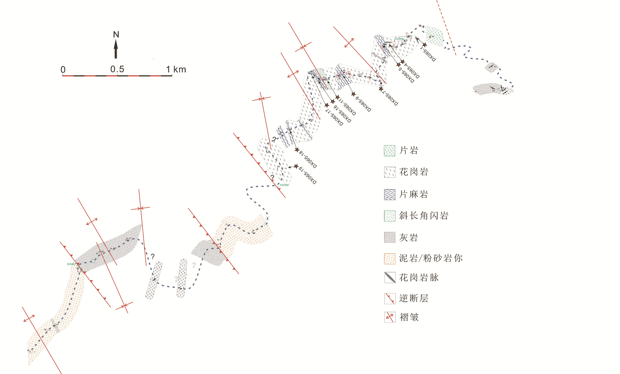 | 图 2 兰坪县河西乡附近清水江路线地质图Fig. 2 Geological map along the Qingshuijiang River near Hexi of Lanping County |
沿清水江两岸出露片岩、片麻岩、斜长角闪岩、花岗岩,以及晚三叠世灰岩-细碎屑岩、第三系泥质粉砂岩、泥岩(图 2)。角闪岩相变质岩位于路线中部,往两侧依次为低级绿片岩相岩石、未变质晚三叠世、或第三系地层。变质岩与未变质岩之间为逆断层。结合片理、片麻理产状变化,整条路线显示若干枢纽走向NNW的背-向形构造(图 2)。淡色花岗岩脉在变质带中比较发育(图 3a),产状变化较大;糜棱岩劈理化强烈(图 3b);片麻岩发生强烈剪切,形成糜棱岩带(图 3c),在褶皱的两翼可见片麻理形成的次级褶皱(图 3d),反映了岩石经历了强烈的挤压作用;片岩分布在剪切带边部(图 3f),主要由黑云母、绿泥石、绢云母、长石及石英组成(图 4a);而片麻岩由长石、石英、云母、角闪石及少量的石榴子石、硅线石组成(图 4b),显示角闪岩相变质组合。
 | 图 3 雪龙山剪切带野外露头照片 (a)糜棱花岗岩中发育淡色花岗岩脉;(b)强烈劈理化的糜棱花岗岩;(c)糜棱岩化的黑云母片麻岩;(d)黑云母片麻岩面理发生褶皱;(e)糜棱花岗岩近于直立的构造面理;(f)出露在剪剪切带边部的石英片岩Fig. 3 Field photographs from Xuelongshan shear zone (a) leucogranite veins intruded in the mylonitic granite; (b) strongly foliated mylonitic granite; (c) mylonitic biotite gneiss; (d) the folded foliation of biotite gneiss; (e) nearly vertical foliation of milonitic granite; (f) the quartze schist in the edge of shear zone |
详细野外考察及镜下研究表明,清水江地区的糜棱岩为S-型、S-L型,即以发育糜棱面理为主,局部发育拉伸线理。糜棱面理陡倾(局部近直立)。近水平方向的切片观察显示,长英质糜棱岩由碎斑(长石、石英集合体)及基质(细粒化石英、绢云母、绿泥石)组成,碎斑发生旋转,形成逐渐变细的拖尾,显现“σ”状(图 4c),指示左行剪切。片麻岩中角闪石碎斑呈眼球状或“δ”状,基质由细粒的石英、长石及黑云母组成(图 4d),也表明其经历了左行剪切作用。白云母片麻岩中发育云母鱼构造,并形成S面理;其与条带状石英、长石集合体条带组成的C面理形成S-C组构(图 4e),指示左行剪切方向。
 | 图 4 雪龙山剪切带典型显微构造照片 (a)长英质糜棱岩中石英与绢云母新晶的定向排列;(b)片麻岩中石榴子石,黑云母集中在石榴子石周围,定向形成面理;(c)片岩中长石“σ”状碎斑与细粒化的基质;(d)角闪石“δ”状碎斑指示左行剪切;(e)白云母片麻岩中的云母鱼构造与S-C组够;(f)绸带状石英集合体与眼球状长石碎斑Fig. 4 Typical microphotos showing the microtextures of tectonites along the Xuelongshan shear zone (a) preferred arrangement of fine sericite and quartz new grains which define foliation in felsic mylonites; (b) biotite flakes surrounding garnet porphyroclast define foliation in gneiss; (c) σ-type porphyroclast preserved in schist; (d) δ-type porphyroclast in quartz-amphibolite suggesting sinistral shearing; (e) numerous mica-fish structures form S-C fabric; (f) quartz-strips and feldspar porphyroclasts in granitic mylonite |
在长英质糜棱岩中,出现了大量由细粒矿物集合体构成的绸带状多晶石英条带环绕眼球状长石碎斑(图 4f),新晶粒边界形态不规则。表明膨胀鼓凸作用(bulging)为主导应变恢复机制,变形温度条件达到了中高温(400~600℃)。
发生糜棱岩化的最年轻岩石为26Ma(作者未发表的锆石原位U/Pb数据)的花岗岩脉,与点苍山、哀牢山中24~26Ma(Schärer et al., 1994)的淡色花岗岩脉具有相似的的年龄。其走向NE-SW,切过糜棱面理,表明剪切作用至少持续到26Ma,但此时剪切作用已经较弱。
在野外调查中,我们发现古近纪的云龙组地层也发生褶皱,形成若干开阔背斜-向斜构造。云龙组地层层面、变质岩片麻理赤平投影结果(图 5a,b)显示,层理、片麻理弯曲形成的褶皱具有相同的褶皱样式、褶皱位态,显见其形成于相同的构造应力场。因而,我们认为雪龙山剪切带发育于云龙组沉积之后(35Ma),即变形时代在35Ma之后。
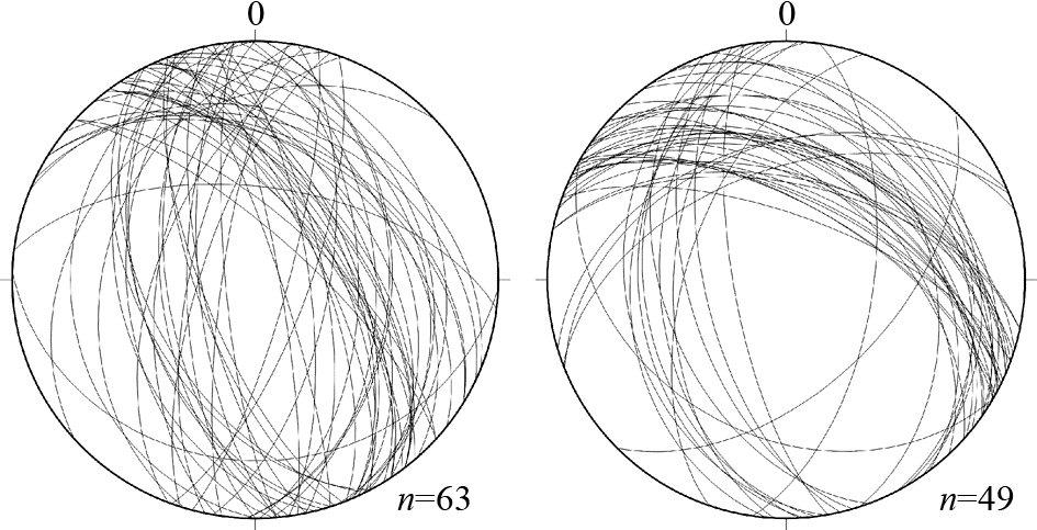 | 图 5 雪龙山构造带片麻理产状(a)和云龙组地层产状(b)下半球极射赤平投影图Fig. 5 Stereonet projections of gneissic foliation of the Xuelongshan shear zone (a) and the bedding of the Yunlong Formation (b) |
广泛发育的开阔褶皱构造、以及S-、SL-型糜棱岩指示挤压缩短应该是雪龙山地区新生代最重要的变形样式。近直立压性构造面(褶皱轴面、糜棱面理)走向NNW、或NW(图 2、图 3),指示最大主压应力方向为NEE或NE。这种应力状态可能与印度与欧亚陆陆持续碰撞、东喜马拉雅构造结向北东挤入有关。
2.3.2 剑川盆地剑川盆地是一个长约100km、宽约40km的菱形盆地,东与扬子地块古生界地层角度不整合接触,西与早-中三叠世火山岩和晚三叠世火山碎屑岩以逆断层方式接触。剑川盆地从基底到盖层主要由三套地层组成(图 6):(1)早-中三叠世火山岩;(2)晚三叠世生物碎屑灰岩、砂岩;(3)第三系碎屑沉积岩。这三套地层以角度不整合的方式互相接触(Yang et al., 2014a),在印度-欧亚陆陆碰撞过程中强烈挤压,盆地基底被抬升出地表,并形成了大量走向NW的压性破劈理,指示SW-NE方向的最大主压应力。变形时间在35~37Ma(Liang et al., 2007; Yang et al., 2014a)之后。
 | 图 6 剑川盆地剖面图(据Yang et al., 2014a修改)Fig. 6 Sketch structural profile across the Jianchuan basin(modified after Yang et al., 2014a) |
点苍山剪切带地处扬子地块西缘,是一个长80km,宽12~20km、NNW走向的变质杂岩体,与哀牢山剪切带之间为未变质的Midu Gap(Tapponnier et al., 1990)。其东西两侧以正断层与中、新生界地层相接触,并在点苍山两侧形成第四系沉积盆地,组成地垒构造(Leloup and Kienast, 1993)。点苍山剪切带岩石组成与雪龙山相似,主要由变质程度达到角闪岩相的片麻岩、斜长角闪岩、大理岩、花岗岩以及绿片岩相岩石组成。主要变形样式表现为发育陡倾斜面理与近水平拉伸线理的糜棱岩。在变质杂岩剪切与剥露过程中记录了三期变形(Cao et al., 2011b),即:(1)早期角闪岩相下的走滑剪切,形成NWW走向糜棱面理与线理以及大量存在的能指示左行剪切方向的各种标志;(2)随后快速的剥露记录了韧性-脆性过渡的变形样式,叠加在早期高温变形形成的构造要素之上;(3)晚期是正断层作用下的脆性变形,最终把中下地壳的韧性物质剥露到地表。
新生代花岗岩在剪切带中普遍发育,根据其构造特点与走滑剪切运动时间上的先后关系可以限定变形的时间,据此可以把该剪切带的变形时间约束在31~20Ma(Cao et al., 2010,2011a)。40Ar/39Ar热年代数据得到的结果表明左行走滑终止于20~17Ma(Leloup and Kienast, 1993)。详细的显微构造观察、背散射电子衍射组构(EBSD)测试证明点苍山早期糜棱岩化作用发生在高温环境,变形条件为636℃、0.653GPa(Cao et al., 2009)。
2.3.4 哀牢山剪切带哀牢山剪切带是一个SE向延伸,长约350km、由不同时代地质单元组合构成的变质-变形带,夹持于兰坪-思茅地块与扬子地块之间,与两侧未变质地层断层接触,并与越南瑶山-大象山剪切带相连延伸至中国南海。其主要由角闪岩相、绿片岩相变质岩组成。Liu et al.(2012)把哀牢山变质杂岩中存在的变形分为三期:第一期为在高温纯剪作用下形成的对称的褶皱、香肠构造以及透镜体,变形温度高达750℃;第二期变形是在哀牢山变质杂岩中广泛存在的单剪变形,野外与镜下的各种不对称标志指示哀牢山经历了左行走滑剪切作用,变形温度在400~600℃;第三期变形为主要分布在变质杂岩边部的脆性正断层。
根据变形与未变形的淡色花岗岩锆石测年结果获得的左行剪切作用时间为27~21Ma(Chung et al., 1997,2008; Cao et al., 2011a; Tang et al., 2013),与40Ar/39Ar测年结果基本一致(Harrison et al., 1996; Leloup et al., 2001)。对哀牢山剪切带中片麻岩的矿物温度-压力估算结果显示剪切带发生左行变形时的温、压条件为650℃、0.5GPa或者更高(Leloup and Kienast, 1993)。
2.3.5 瑶山-大象山(DNCV)剪切带越南北部的瑶山-大象山剪切带是一个NE-SE走向、宽约20km、长约270km、主要由片麻岩、斜长角闪岩及大量花岗岩脉体组成的变质-变形杂岩带。其表现为一个大型背形构造(Jolivet et al., 2001; Anczkiewicz et al., 2007),东西边界分别为北东倾向的Song Chay断层和南西倾向的Song Hong断层。在变质杂岩的核部很少记录有与走滑剪切有关的标志(Viola and Anczkiewicz, 2008),而两翼断层附近表现出韧性剪切的特点,形成中等到高角度倾向的糜棱面理与近水平的线理。变质杂岩边界构造带内发育有一些不对称小褶皱和近于直立的线理,被认为是变质杂岩在转换拉张的条件下隆升过程中形成的构造(Anczkiewicz et al., 2007)。
大量的Ar-Ar、K-Ar数据揭示了DNCV的热演化过程,角闪石的测年结果在34~27Ma之间(Nam et al., 1998; Wang et al., 2000; Leloup et al., 2001),白云母的40Ar/39Ar年龄在33~24Ma之间,黑云母40Ar/39Ar年龄为23~26Ma,这些不同的矿物具有不同的K-Ar同位素封闭温度,这些数据可以推测DNCV变质杂岩的剥露过程。但比较奇怪的是,磷灰石的裂变径迹测龄结果在30~25Ma,可能反应该变质杂岩隆升过程的空间不均匀性(Viola and Anczkiewicz, 2008)。
在哀牢山-红河左行走滑作用结束之后,Deng et al.(2014a)把10~0Ma的地质过程归纳为伸展旋钮阶段,表现为三江东南部地区伸展构造与相应的岩浆侵位事件(Flower et al., 2013),理解为印度-欧亚陆陆碰撞系与太平洋俯冲系两个动力系统相互作用的结果(Burchfiel and Chen, 2012; Deng et al., 2014a)。该阶段与Liu et al.(2007)、Cao et al.(2011b)所提出的印支地块进入慢速旋转作用的时间相对应。约5Ma开始,ARSZ开始了右行走滑作用,是加厚的地壳伸展塌陷的结果(Leloup and Kienast, 1993)。关于ARSZ的走滑距离,不同的研究方法得到的结论不尽相同,如根据地质标志(缝合线、超钾火山岩、沉积盆地)偏移量得到500~700km的走滑距离(Leloup et al., 1995,2001),但是Searle(Searle,2006; Searle et al., 2010)对这些地质标志的可拼接性与精确性提出质疑,认为走滑距离是相对较小的;中国南海海盆的地磁数据表明550km的走滑量(Briais et al., 1993);Mazur et al.(2012)通过对中国南海海盆重力数据反演的研究,支持250km的走滑距离。
上述三条大型走滑剪切带是三江地区最重要的构造带,它们具有许多相似的地方,如组成剪切带岩石组合、构造特点、变质程度等。但是,现有数据表明,这些剪切带的形成时代、主体构造样式、变形历史存在很大差异,综合分析现有数据,提炼不同剪切带变形历史的空间变化规律,有可能帮助我们构建这些剪切带的形成、演化与印度-欧亚陆陆碰撞之间的、更合理的动力学关联。
3 三江构造带新生代变形启动时间的空间变化及动力学含义在陆陆碰撞过程中涉及陆块刚体运动以及强烈的地壳缩短(陆块内部变形),必然存在变形作用的空间迁移。厘清三江地区主要剪切带主体变形启动时间的空间变化规律可以很好限定这些剪切带与陆陆碰撞之间的动力学关系。
从现有数据看,位于兰坪-思茅地块西侧的崇山剪切带在38Ma之前开始遭受挤压变形(Zhang et al., 2010),形成区域性褶皱-逆断层组合,代表最早期的纯剪应变。随着印度板块逐渐向NNE方向挤入,应力场转化为转换挤压,并于34~32Ma开始发生简单剪切应变(Akciz et al., 2008; Zhang et al., 2010)。而位于兰坪-思茅地块东侧的哀牢山-红河剪切带韧性剪切,虽然争议较大,其开始变形的时代明显要晚于崇山剪切带。36~34Ma(Schärer et al., 1994; Liang et al., 2007; Lu et al., 2012)的高钾碱性火山岩为区域上广泛存在的一期高钾岩浆事件,侵位发生于走滑剪切之前(Searle,2006; Chung et al., 2008)。所以哀牢山-红河剪切带剪切作用可能开始于28~27Ma(Chung et al., 1997; Wang et al., 2000; Cao et al., 2011a)。在兰坪盆地内部,35Ma(Yang et al., 2014a)之后开始受到挤压作用的影响,使稳定的沉积环境开始改变,并最终把盆地基底抬升出地表。由此可见,三江构造带新生代变形具有从西往东逐渐扩展之趋势。
现有数据还表明,同一条剪切带的启动时间似乎有从南向北变晚的趋势。Akciz et al.(2008)用剪切带中独居石的年龄去限定左行剪切开始的时间,对崇山剪切带中独居石U-Pb年龄测试结果为:瓦窑地区为41~34Ma,北部的漕涧地区变为26~24Ma,再向北利沙底为24.5~26Ma,最北部的贡山地区为17.5~16.5Ma,表明左行剪切作用由南向北扩展,白云母、黑云母热年代数据(Wang et al., 2006; Akciz et al., 2008; Zhang et al., 2010,2012b)支持该结论(见下文)。Harrison et al.(1996)通过对哀牢山-红河剪切带中不同矿物的40Ar/39Ar热年代测定,认为剪切运动由南东向北西扩展,并计算出扩展速率为4.5cm/a。考虑到三江地区其它大型左行走滑断层启动的时间,如右行的高黎贡剪切带开始作用于18~16Ma(Lin et al., 2009; Zhang et al., 2012a)、Three Pogoda走滑断层(≥36Ma)、Wang Chao走滑断层(≥36Ma)及鲜水河-小江走滑断层(≥15Ma),暗示了左行走滑断层越靠北左行剪切启动的时间越晚(Lacassin et al., 1997)。
这种空间变化规律表明,(1)剪切作用确由陆陆碰撞造成;(2)相对于印支地块,印度大陆在主动向北运移,与古地磁研究结果(Klootwijk et al., 1992)吻合,地块的逃逸在陆陆碰撞过程中所起到的作用有限。
4 主要剪切带主体变形样式的空间变化及其动力学含义高黎贡剪切带总体表现为右行走滑。崇山-碧罗雪山剪切带不同位置剪切方式完全不同:北段(碧罗雪山)主体变形样式为右行走滑,而其中段、南段均表现为左行走滑运动。这种变化方式可能与其所处构造位置的不同有关:高黎贡剪切带以及崇山-碧罗雪山剪切带北段更靠近喜马拉雅东构造结,而且剪切变形启动时间较晚,其变形更大程度受控于印度地块的向北运动,而非欧亚板块内部小陆块的向南逃逸。
点苍山以北的剑川盆地与雪龙山变质带褶皱与逆断层的变形特点说明,雪龙山-点苍山-哀牢山-红河剪切带的最北段自印度与欧亚陆陆碰撞以来,一直受挤压应力控制,始终发生纯剪变形。而点苍山及以南的剪切带应变则随时间演化发生变化,表现为早期的纯剪变形、中期的单剪变形与晚期的脆性变形(Liu et al., 2012)。表明该构造带南端发生了转换拉张(Anczkiewicz et al., 2007; Viola and Anczkiewicz, 2008),且越往南(如越南DNCV剪切带)转换拉张作用越明显。所以剪切带相对于喜马拉雅东构造结的空间位置决定了剪切带变形样式。此外,该剪切带由北向南出露变宽、地势更平缓的特点也支持该论点(Harrison et al., 1996)。
这种空间变化特点表明,(1)碰撞初期以挤压变形为主,最大主压应力方向以NE-SW为主,与东喜马拉雅构造结延伸方向一致;(2)崇山-碧罗雪山剪切带剪切方向的空间变化并不支持印支地块整体向南逃逸模型;(3)走滑变形开始于碰撞的中晚期,暗示挤压之后确有可能发生了逃逸,也有可能与地块旋转有关。可以合理推测,印支地块向南逃逸的距离不会太大,而且内部发生了刚体旋转以及内部变形。
5 主要剪切带的热演化史空间变化及动力学含义不同的矿物具有不同的同位素体系封闭温度,可以较好记录岩石的冷却历史,进而推断地质体的抬升过程。如角闪石氩-氩体系的封闭温度在500~550℃(Harrison,1981),白云母约425℃(Harrison et al., 2009),黑云母275~300℃(Harrison et al., 1985);钾长石氩-氩体系封闭温度最低,约在250~160℃之间(Lovera et al., 1989)。近年积累了大量针对三江地区主要剪切带开展的不同矿物同位素分析数据(数据统计表见表 1),为我们分析不同剪切带冷却历史的空间变化奠定了基础。
| 表 1 红河-哀牢山、崇山-碧罗雪山、高黎贡剪切带40Ar-39Ar分析结果及数据来源Table 1 Previously published 40Ar-39Ar results of the Ailaoshan, Chongshan-Biluoxueshan, and Gaoligong shear zones |
现有数据表明高黎贡剪切带整体具有高度一致的隆升历史(图 7)。其剥露过程大致可以分为二个阶段:第一个阶段是自50Ma开始,持续到20Ma,为一个缓慢的隆升过程,冷却速率为9.3℃/Myr。自18Ma之后,剥露速率开始加快,白云母、黑云母氩氩结果推断的冷却速率为50℃/Myr(Lin et al., 2009; Zhang et al., 2012a)。这种冷却历史,结合其右行走滑变形样式,表明早期走滑作用发生在挤压构造背景,地壳加厚造成隆升,而晚期走滑作用则发生在伸展背景,造成快速隆升。
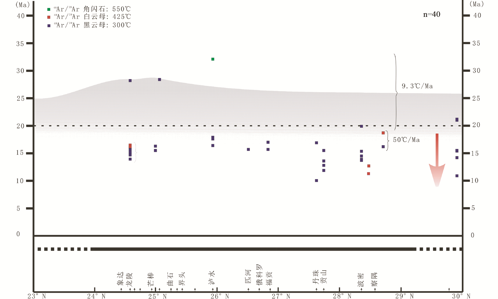 | 图 7 高黎贡剪切带构造-热状态的空间变化Fig. 7 Geothermal pattern along the Gaoligong shear zone |
相对高黎贡剪切带,崇山剪切带具有不同的冷却样式。崇山剪切带走滑剪切开始于34~22Ma,可能持续到16Ma(Akciz et al., 2008; Zhang et al., 2012b),变质杂岩的快速剥露过程几乎与剪切作用同时开始,其冷却速率达到57.6℃/Myr,但南段明显早于北段(图 8)。考虑到其南、北两段所处的构造位置不同(图 1),更兼具有不同的变形样式,我们认为北段与南段快速隆升的原因可能不同:北段由喜马拉雅东构造结的强烈挤压造成,而南段则可能与腾冲-保山地块向南运动造成的压扭应变有关。
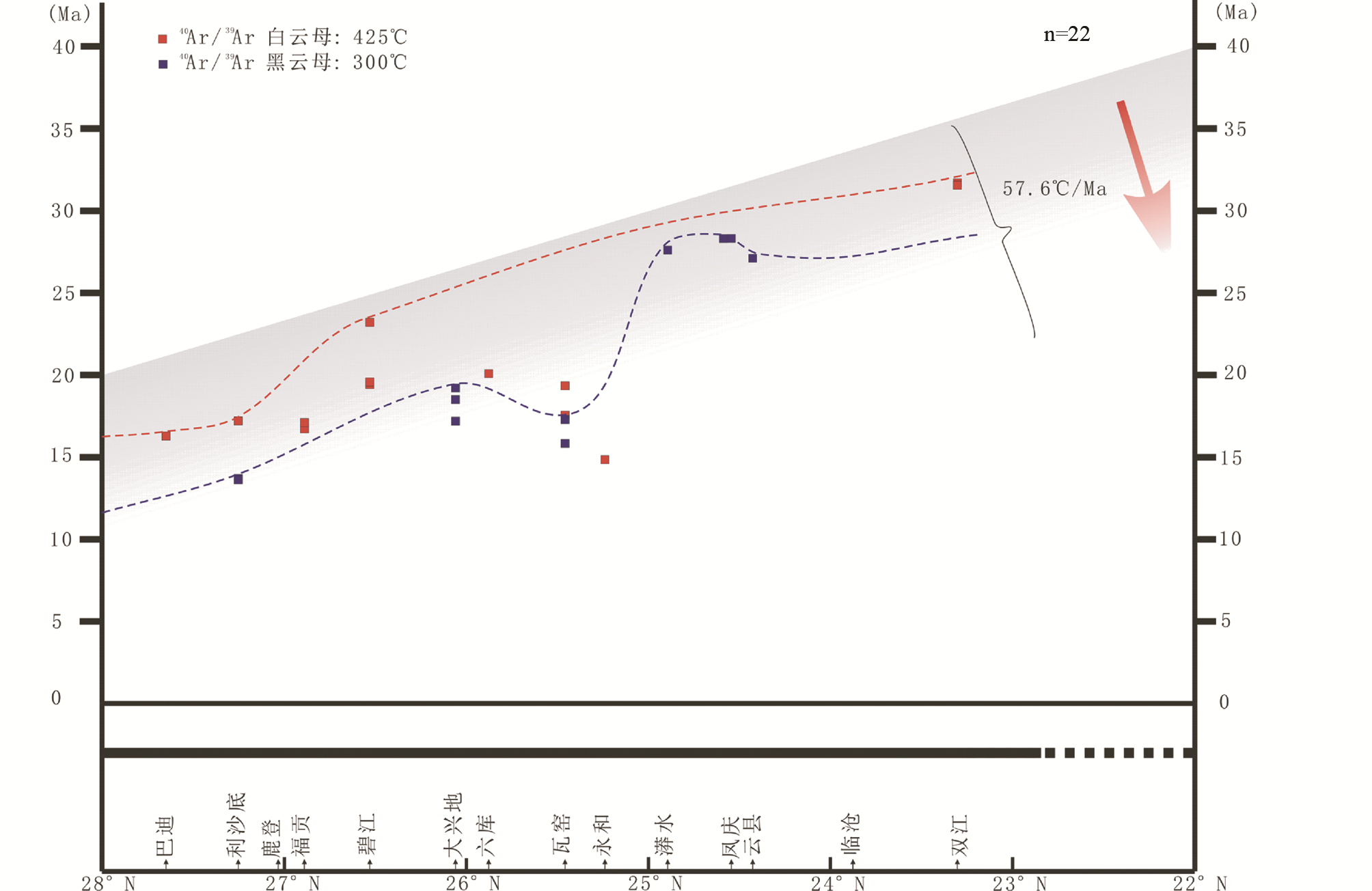 | 图 8 崇山剪切带构造-热状态的空间变化Fig. 8 Geothermal pattern along the Chongshan shear zone |
哀牢山-红河剪切带剥露过程在三条剪切带中最为复杂。角闪石40Ar/39Ar年龄结果显示该剪切带在早期30~25Ma之间具有较一致的冷却速率(雪龙山带除外),冷却速率为7.1℃/Myr。自25Ma开始,剪切带差异性的隆升过程表现越来越明显,其南部略早于其北部开始隆升,且隆升速率也大于北部。但20Ma之后,南端的冷却速率远远大于北段:南段为93.7℃/Myr,甚至达到110℃/Myr(Nam et al., 1998),北段仅为16.2℃/Myr(图 9)。这种剥露过程的特点可能与伸展作用自南向北依次传播相关。最北端的雪龙山处于碰撞前缘位置,变形样式与剥露过程都表现出不一致的特点。在28Ma左右,雪龙山剪切带的温度降至黑云母的封闭体系温度(300℃),此时的点苍山、哀牢山、瑶山-大象山地区则仍处于角闪石封闭体系温度(550℃)之上。
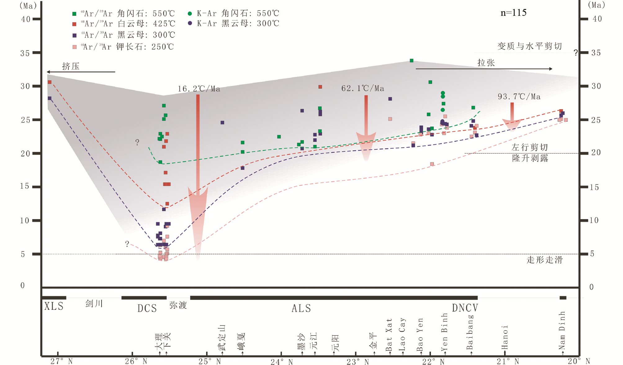 | 图 9 哀牢山-红河剪切带构造-热状态的空间变化Fig. 9 Geothermal pattern along the Ailaoshan-Red River shear zone |
左行的哀牢山-红河剪切带与崇山剪切带的发育及印支地块的旋转,在印度与欧亚陆陆碰撞中后期已经不能调节印度大陆的持续的向北挤入,夹持于东喜玛亚拉构造结与印支地块的保山地块没有足够的空间旋转而向南逃逸,如此的变形特点使得高黎贡剪切带具有相对统一的剥露历史,与以地块旋转为主导调节机制的兰坪-思茅地块表现出的南北向变化不同。而且,保山地块向南迁移的速率明显大于印支地块(Wang et al., 2006; Kornfeld et al., 2014)。
从上述讨论可以看出,早期形成的左行剪切带南段隆升速率均大于北段。而且,越靠近印度大陆,发生差异隆升的时间越早。这种特点可能与印度大陆的初始形态及迁移路径有关。
6 古地磁研究及块体内部变形古地磁研究作为定量恢复古构造运动的有效手段之一,其测量结果为了解兰坪-思茅盆地内部的变形与块体旋转提供了重要的证据。前人根据晚中生界-早新生界地层的古地磁数据提出,兰坪-思茅盆地相对于扬子板块可能向南迁移了500~1000km,及0°~90°的顺时针旋转(Otofuji et al., 1990; Funahara et al., 1993; Chen et al., 1995; Charusiri et al., 2006; Takemoto,2006; Sato et al., 2007; Tanaka et al., 2008)。当然,在构造变形十分复杂地区获得的古地磁数据,其精度是存疑的。
对白垩系、古近系地层的古地磁数据统计结果(表 2、图 10)显示,印支地块在挤出过程中,并不是作为一个整体向南逃逸的(Kornfeld et al., 2014),尤其在兰盆-思茅地块内,在向东南方向移动过程中其内部出现了解耦。在景谷、兰坪附近,自始新世以来发生了90°的地块旋转(Chen et al., 1995; Sato et al., 2001),而且在其他地区地块旋转角度明显变小(Chen et al., 1995)。显然,在逃逸过程中,块体内部发生了强烈变形(如Burchfiel and Chen, 2012)。在点苍山剪切带东侧的下关地区,古地磁数据显示几乎未发生块体旋转(Huang and Opdyke, 1993),表明点苍山剪切带的左行运动可能与其西侧块体的顺时针旋转有关。另外,白垩纪地层古地磁结果显示,越南DNCV剪切带南西侧的Song Da地体相对欧亚大陆无南北向迁移(Takemoto et al., 2005)。这些数据清晰表明,在陆陆碰撞中块体内部必定发生了复杂变形。
| 表 2 印支地块、扬子地块古地磁测量结果(旋转量)及数据来源Table 2 Previously published paleomagnetic results of the Indu-Sinian and Yangtze blocks |
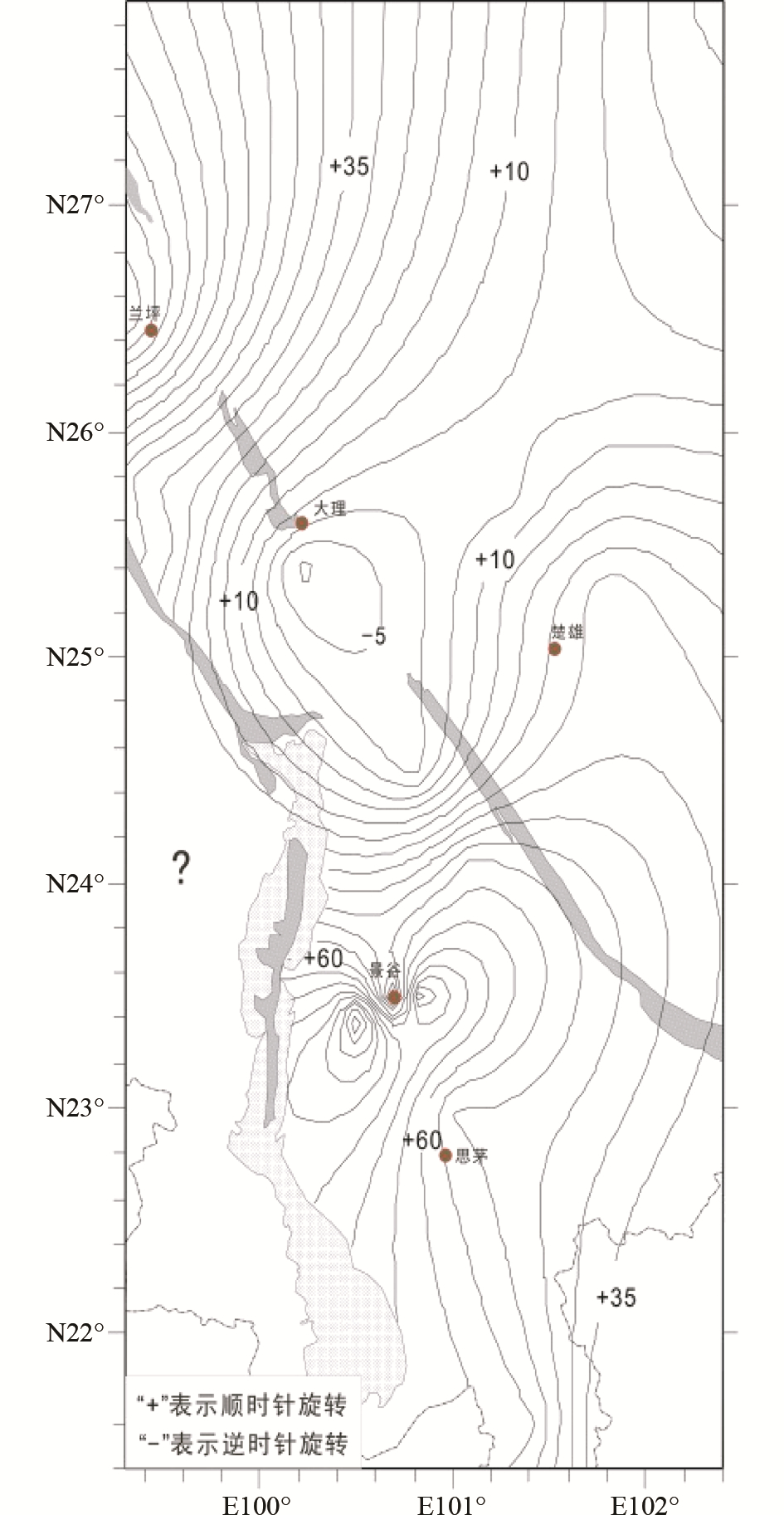 | 图 10 东喜马拉雅构造结东部地块内部旋转量等值线图(根据表 2数据编制)Fig. 10 Distribution pattern of block rotation of the region east of the Eastern Himalayan Syntaxis(for data source,see Table 2) |
印支地块内部的中、新生代地层发生变形,形成了褶皱与逆断层组合;另外,块体边界往往呈现高角度逆断层。褶皱轴迹与断层组成的构造线总体NNW走向,局部弯曲呈弓状,并被NE走向的左行走滑断层截断。结合古地磁资料,表明在挤压变形之后,块体发生了不均匀旋转。所以,ARSZ并非是印支地块向南挤出过程中形成的一条连续的边界断层;兰坪-思茅地块内部的不均匀变形可能是地块被断层带支解后局部小地块不均匀旋转的结果(Chen et al., 1995)。
7 讨论:三江构造带新生代应变场的时空变化兰坪-思茅地块及两侧的剪切带因其与印度地块之间不同的空间关系而表现出不同的变形历史。随着印度地块持续向北楔入欧亚地块南缘,应变场随时间改变,表现出不同的构造样式。50~35Ma,主要表现为三江构造的强烈挤压,挤压应力向北东逐渐传播,约在36Ma的一期富钾岩浆事件暗示地块的伸展作用;自35Ma与30Ma开始,在兰坪-思茅盆地西东两侧分别开始发育左行剪切走滑作用,表现出由西向东、自南而北传播的特点;20~15Ma,ARSZ与CSSZ已基本停止活动,开始活跃另一条右行剪切带GLSZ,三条剪切带最终将中下地壳的韧性物质剥露出地表,并表现出不均一性的特点;5Ma开始,ARSZ开始活跃为右行走滑断层,一直持续到现在。综合前人数据,结合我们自己的研究结果,推测如下三江构造带新生代构造演化过程(图 11),注意应变场随着喜马拉雅东构造结(EHS)在迁移过程中的变化。
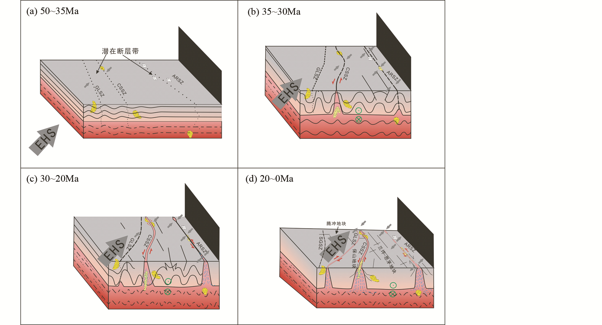 | 图 11 兰坪-思茅地块两侧剪切带演化历史(讨论见正文)Fig. 11 Deformation history of the shear zones along the western and eastern boundaries of the Lanping-Simao block (see text for detail discussion) |
印度板块与欧亚板块在约50Ma开始碰撞,拼贴在一起的多个地块开始受到印度板块挤压的影响。腾冲地块与保山地块位于碰撞的前缘位置,最先受到挤压的影响,在块体内部形成弥散状、构造线NW走向的褶皱+逆断层组合。由于印度地块持续向北运动,地块西侧边界受右行挤压应力控制(Wang et al., 2001; Zhang et al., 2010),但此时并没有形成大规模走滑构造。在此时位于碰撞带东部的兰坪-思茅盆地以及剑川盆地尚未受到该区域应力的影响,处于相对稳定的环境中,接受沉积形成新生代沉积岩(图 11a)。在36Ma左右,三江构造带东部的金沙江-剑川-哀牢山地区发育一期重要的富钾岩浆事件,Deng et al.(2014a)理解为岩石圈地幔伸展拆沉的结果。
7.2 35~30Ma随着印度地块持续向北、东运动,腾冲、保山地块向南挤出,造成兰坪-思茅地块西部的崇山剪切带开始发生左行走滑剪切运动;同时褶皱+逆断层的构造组合扩展到兰坪-思茅地块内部。变形的启动时间、剪切带的隆升时间均具有从南往北变晚的趋势。构造带最北端的碧罗雪山剪切带北段、雪龙山剪切带、剑川盆地等,特别是后两者基本没有记录走滑变形(图 11b)。
7.3 30~20Ma在该时间段内,三江构造带,特别是南段开始发生大范围的走滑剪切作用(Wang et al., 2000; Cao et al., 2011a,2012; Zhang et al., 2012b)。有意思的是,详细研究表明,兰坪-思茅盆地两侧的剪切带(崇山剪切带与哀牢山-红河剪切带)在该时段均表现为左行走滑(图 11c)。在此时段内,大量下地壳物质被快速、但不均匀地剥露出地表。不均匀性不单表现在空间上,而且还表现在剥露时间、剥露速率上。这显然与地块的不均匀旋转有关。
7.4 20~0Ma该阶段大部分韧性剪切作用已基本停止(图 11d),哀牢山-红河剪切带南段在伸展作用下开始受到正滑剪切的控制,下地壳物质继续向上抬升,直至剥露出地表,形成现在所呈现的具有东西向(或北东-南西向)陡倾面理与南北向(南东向)近水平线理的构造特点,以及在变质杂岩边部发育的具有高倾角北东走向的拉伸线理。在剪切带中发育有大量的结晶岩脉,其完整的岩浆结构是剪切运动结束最好的证据之一。但在保山地块与腾冲地块的边界,在此期间形成了另一条大型的走滑剪切带即高黎贡剪切带,它的剥露过程紧随走滑剪切作用而进行,并在该过程南北段表现出剥露速率的统一性。这可能与印度板块持续碰撞有关,是调节地块挤入变形效应的结果。ARSZ于5Ma开始的右行走滑作用,是加厚的地壳持续伸展塌陷的结果,进一步调节着印度-欧亚陆陆碰撞作用。
8 结论(1)三江构造带新生代变形构造具有强烈的时空不均匀性,难以用简单的挤出模型解释这些构造现象。
(2)兰坪-思茅(印支)地块两侧的剪切带均具有早期纯剪(挤压)、中期简单剪切(走滑)、晚期拉张(隆升)的变形历史。对于单一剪切带,各变形阶段具有南早北晚的趋势。
(3)印度与欧亚大陆的碰撞变形效应在三江地区主要被陆块内部的弥散状挤压变形与块体刚性旋转所吸收,块体向南逃逸的规模不似以往认为的那么大。
致谢 审稿人及责任编辑的审稿意见极大地提高了本文质量。| [1] | Achache J, Courtillot V and Besse J. 1983. Paleomagnetic constraints on the Late Cretaceous and Cenozoic tectonics of southeastern Asia. Earth and Planetary Science Letters, 63(1):123-136 |
| [2] | Akciz S, Burchfiel BC, Crowley, Yin JY and Chen LZ. 2008. Geometry, kinematics, and regional significance of the Chong Shan shear zone, Eastern Himalayan Syntaxis, Yunnan, China. Geosphere, 4(1):292-314 |
| [3] | Anczkiewicz R, Viola G, Müntener O, Thirlwall MF, Villa IM and Quong NQ. 2007. Structure and shearing conditions in the Day Nui Con Voi massif:Implications for the evolution of the Red River shear zone in northern Vietnam. Tectonics, 26(2):TC2002, doi:10.1029/2006TC001972 |
| [4] | Beaumont C, Jamieson RA, Nguyen MH and Medvedey S. 2004. Crustal channel flows:1. Numerical models with application to tectonics of the Himalaya-Tibetan orogeny. Journal of Geophysical Research, 109(B6):B06406, doi:10.1029/2003JB002809 |
| [5] | Briais A, Patriat P and Tapponnier. 1993. Updated interpretation of magnetic anomalies and seafloor spreading stages in the South China Sea:Implications for the Tertiary tectonics of Southeast Asia. Journal of Geophysical Research, 98(B4):6299-6328 |
| [6] | Burchfiel BC and Wang E. 2003. Northwest-trending, Middle Cenozoic, left-lateral faults in southern Yunnan, China, and their tectonic significance. Journal of Structural Geology, 25(5):781-792 |
| [7] | Burchfiel BC and Chen ZL. 2012. Tectonics of the Southeastern Tibetan Plateau and Its Adjacent Foreland. Boulder, Colo., USA. The Geological Society of America, 1-231 |
| [8] | Cao SY, Liu JL and Leiss B. 2009. Deformation microstructures and textures, and regional tectonic significance of high-temperature shearing of the Diancang Shan Complex, Yunnan, Chinan. Trabajos de Geología, 29:133-141 |
| [9] | Cao SY, Liu JL, Leiss B and Zhao CQ. 2010. New zircon U-Pb geochronology of the post-kinematic granitic plutons in the Diancang Shan metamorphic massif along the Ailao Shan-Red River shear zone and its geological implication. Acta Geological Sinica, 86(4):1474-1487 |
| [10] | Cao SY, Liu JL, Leiss B, Neubauer F, Genser J and Zhao CQ. 2011a. Oligo-Miocene shearing along the Ailao Shna-Red River shear zone:Constraints from structural analysis and zircon U/Pb geochronology of magmatic rocks in the Diancang Shan massif, SE Tibet, China. Gondwana Research, 19(4):975-993 |
| [11] | Cao SY, Neubauer F, Liu JL, Genser J and Leiss B. 2011b. Exhumation of the Diancang Shan metamorphic complex along the Ailao Shan-Red River belt, southwestern Yunnan, China:Evidence from 40Ar/39Ar thermochronology. Journal of Asian Earth Sciences, 42(3):525-550 |
| [12] | Cao SY, Liu JL, Leiss B, Vollbrecht A, Genser J, Neubauer F and Zhao CQ. 2012. Initiation of left-lateral deformation along the Ailao Shan-Red River shear zone:New microstrutural, textural, and geochronological constraints from the Diancang Shan metamorphic massif, SW Yunnan, China. International Geology Review, 54(3):348-367 |
| [13] | Charusiri P, Imsamut S, Zhuang ZH, Ampaiwan T and Xu XH. 2006. Paleomagnetism of the Earliest Cretaceous to early Late Cretaceous sandstones, Khorat Group, Northeast Thailand:Implications for tectonic plate movement of the Indochina block. Gondwana Research, 9(3):310-325 |
| [14] | Chen HH, Dobson J, Heller F and Hao J. 1995. Paleomagnetic evidence for clockwise rotation of the Simao region since the Cretaceous:A consequence of India-Asia collision. Earth and Planetary Science Letters, 134(1-2):203-217 |
| [15] | Chung SL, Lee TY, Lo CH, Wang PL, Chen CY, Yem NT, Hoa TT and Genyao W. 1997. Intraplate extension prior to continental extrusion along the Ailao Shan-Red River shear zone. Geology, 25(4):311-314 |
| [16] | Chung SL, Searle MP and Yeh MW. 2008. The age of the potassic alkaline igneous rocks along the Ailao Shan-Red River shear zone:Implications for the onsets age of left-lateral shearing:A discussion. The Journal of Geology, 116(2):201-204 |
| [17] | Deng J, Hou ZQ, Mo XX, Yang LQ, Wang QF and Wang CM. 2010. Superimposed orogenesis and metallogenesis in Sanjiang Tethys. Mineral Deposits, 29(1):37-42(in Chinese with English abstract) |
| [18] | Deng J, Wang QF, Li GJ and Santosh M. 2014a. Cenozoic tectono-magmatic and metallogenic processes in the Sanjiang region, southwestern China. Earth-Science Reviews, 138:268-299 |
| [19] | Deng J, Wang QF, Li GJ, Li CS and Wang CM. 2014b. Tethys tectonic evolution and its bearing on the distribution of important mineral deposits in the Sanjiang region, SW China. Gondwana Research, 26(2):419-437 |
| [20] | Deng J and Wang QF. 2015. Gold mineralization in China:Metallogenic provinces, deposit types and tectonic framework. Gondwana Research, doi:c10. 1016/j.gr.2015.10.003 |
| [21] | Deng J, Wang QF, Li GJ and Zhao Y. 2015. Structural control and genesis of the Oligocene Zhenyuan orogenic gold deposit, SW China. Ore Geology Reviews, 65:42-54 |
| [22] | England P and Houseman G. 1986. Finite strain calculations of continental deformation:2. Comparison with the India-Asia collision zone. Journal of Geophysical Research, 91(B3):3664-3676 |
| [23] | England P and Molnar P. 1997. The field of crustal velocity in Asia calculated from Quaternary rates of slip on faults. Geophysical Journal International, 130(3):551-582 |
| [24] | Feng QL, Chonglakmani C, Helmcke D, Ingavat-Helmcke R and Liu BP. 2005. Correlation of Triassic stratigraphy between the Simao and Lanping-Phrae Basins:Implications for the tectonopaleogeography of Southeast Asia. Journal of Asian Earth Sciences, 24(6):777-785 |
| [25] | Flower MFJ, Hoàng N, Lo CH, Chi CT, Cu'ò'ng NQ, Liu FT, Deng JF and Mo XX. 2013. Potassic magma geneisis and Ailao Shan-Red River fault. Journal of Geodynamics, 69:84-105 |
| [26] | Funahara S, Nishiwaki N, Miki M, Murata F, Otofuji Y and Wang YZ. 1992. Paleomagnetic study of Cretaceous rocks from the Yangtze block, central Yunnan, China:Implications for the India-Asia collision. Earth and Planetary Science Letters, 113(1-2):77-91 |
| [27] | Funahara S, Nishiwaki N, Murata F, Otofuji Y and Wang YZ. 1993. Clockwise rotation of the Red River fault inferred from paleomagnetic study of Cretaceous rocks in the Shan-Thai-Malay block of western Yunnan, China. Earth and Planetary Science Letters, 117(1-2):29-42 |
| [28] | Garzanti E and Van Haver T. 1988. The Indus clastics:Forearc basin sedimentation in the Ladakh Himalaya (India). Sedimentary Geology, 59(3-4):237-249 |
| [29] | Gilley LD, Harrison TM, Leloup PH, Ryerson FJ, Lovera OM and Wang JH. 2003. Direct dating of left-lateral deformation along the Red River shear zone, China and Vietnam. Journal of Geophysical Research, 108(B2):2127, doi:10.1029/2001JB001726 |
| [30] | Green OR, Searle MP, Corfield RI and Corfield RM. 2008. Cretaceous-Tertiary carbonate platform evolution and the age of the India-Asia collision along the Ladakh Himayala (Northwest India). The Journal of Geology, 116(4):331-353 |
| [31] | Harrison TM. 1981. Diffusion of 40Ar in hornblende. Contributions to Mineralogy and Petrology, 78(3):324-331 |
| [32] | Harrison TM, Duncan I and Mcdougall I. 1985. Diffusion of 40Ar in biotite:Temperature, pressure and compositional effects. Geochimica et Cosmochimica Acta, 49(11):2461-2468 |
| [33] | Harrison TM, Chen WJ and Leloup PH. 1992. An Early Miocene transition in deformation regime within the Red River fault zone, Yunnan, and its significance for Indo-Asian tectonics. Journal of Geophysical Research, 97(B5):7159-7182 |
| [34] | Harrison TM, Leloup PH, Ryerson FJ, Tapponnier P, Lacassin R and Chen WJ. 1996. Diachronous initiation of transtension along the Ailao Shan-Red River shear zone, Yunnan and Vietnam. In:Yin A and Harrision TM (eds). The Tectonic Evolution of Asia. New York:Cambridge University Press, 208-226 |
| [35] | Harrison TM, Célérier J, Ailman AB, Hermann J and Heizler MT. 2009. Diffusion of 40Ar in muscovite. Geochimica et Cosmochimica Acta, 73(4):1039-1051 |
| [36] | Houseman G and England P. 1986. Finite strain calculations of continental deformation:1. Method and general results for convergent zones. Journal of Geophysical Research, 91(B3):3651-3663 |
| [37] | Huang KN and Opdyke ND. 1992. Paleomagnetism of Cretaceous to Lower Tertiary rocks from South and Southwest Sichuan:A revisit. Earth and Planetary Science Letters, 112(1-4):29-40 |
| [38] | Huang KN and Opdyke ND. 1993. Paleomagnetic results from Cretaceous and Jurassic rocks of South and Southwest Yunnan:Evidence for large clockwise rotations in the Indochina and Shan-Thai-Malay terranes. Earth and Planetary Science Letters, 117(3-4):507-524 |
| [39] | Jin XC, Huang H, Shi YK and Zhan LP. 2011. Lithological boundaries in Permian post-glacial sediments of the Gondwana-affinity regions of China:Typical sectional, age range and correlation. Acta Geologica Sinica, 85(2):373-386 |
| [40] | Jin XC, Huang H, Shi YK and Zhan LP. 2014. Permo-Carboniferous successions of the Tengchong block, western Yunnan, China:Status and Problems. In:Rocha R, Pais J, Kullberg JC and Finney S (eds). STRATI 2013. Springer International Publishing, 767-771 |
| [41] | Jolivet L, Beyssac O, Goffé B, Avigad D, Lepvrier C, Maluski H and Thang TT. 2001. Oligo-Miocene midcrustal subhorizontal shear zone in Indochina. Tectonics, 20(1):46-57 |
| [42] | Klootwijk CT, Gee JS, Peirce JW, Smith GM and Mcfadden PL. 1992. An early India-Aisa contact:Paleomagnetic constraints from Ninetyeast Ridge, ODP Leg 121. Geology, 20(5):395-398 |
| [43] | Kornfeld D, Eckert S, Appel E, Ratschbacher L, Pfänder J, Liu DL and Ding L. 2014. Clockwise rotation of the Baoshan Block due to southeastward tectonic escape of Tibetan crust since the Oligocene. Geophysical Journal International, 197(1):149-163 |
| [44] | Lacassin R, Maluski H, Leloup H, Tapponnier P, Hinthong C, Siribhakdi K, Chuaviroj and Charoenravat A. 1997. Tertiary diachronic extrusion and deformation of western Indochina:Structural and 40Ar/39Ar evidence from NW Thailand. Journal of Geophysical Research, 102(B5):10013-10037 |
| [45] | Leloup PH, Harrisom TM, Ryerson FJ, Chen WJ, Li Q, Tapponnier P and Lacassin R. 1993. Structural, petrological and thermal evolution of a tertiary ductile strike-slip shear zone, Diancang Shan, Yunnan. Journal of Geophysical Research, 98(B4):6715-6743 |
| [46] | Leloup PH and Kienast JR. 1993. High-temperature metamorphism in a major strike-slip shear zone:The Ailao Shan-Red River, People's Republic of China. Earth and Planetary Science Letters, 118(1-4):213-234 |
| [47] | Leloup PH, Lacassin B, Tapponnier P, Schärer U, Zhong DL, Liu XH, Zhang LS, Ji SC and Trinh PT. 1995. The Ailao Shan-Red River shear zine (Yunnan, China), Tertiary Transform boundary of Indochina. Tectonophysics, 251(1-4):3-10, 13-84 |
| [48] | Leloup PH, Arnaud N, Lacassin R, Kienast JR, Harrison TM, Trong TTP, Replumaz A and Tapponnier P. 2001. New constraints on the structure, thermochronology, and timing of the Ailao Shan-Red River shear zone, SE Asia. Journal of Geophysical Research, 106(B4):6683-6732 |
| [49] | Liang HY, Campbell IH, Allen CM, Sun WD, Yu HX, Xie YW and Zhang YQ. 2007. The age of the potassic alkaline igneous rocks along the Ailao Shan-Red River shear zone:Implications for the onset age of left-lateral shearing. The Journal of Geology, 115(2):231-242 |
| [50] | Lin TH, Lo CH, Chung SL, Hsu FJ, Yeh MW, Lee TY, Ji JQ, Wang YZ and Liu DY. 2009. 40Ar/39Ar dating of the Jiali and Gaoligong shear zones:Implications for crustal deformation around the Eastern Himalayan Syntaxis. Journal of Asian Earth Sciences, 34(5):674-685 |
| [51] | Lin TH, Chung SL, Chiu HY, Wu FY, Yeh MW, Searle MP and Lizuka Y. 2012. Zircon U-Pb and Hf isotope constraints from the Ailao Shan-Red River shear zone on the tectonic and crustal evolution of southern China. Chemical Geology, 291:23-37 |
| [52] | Liu JL, Cao SY, Zhai YF, Song ZJ, Wang AJ, Xiu QY, Cao DH, Gao L and Guan Y. 2007. Rotation of crustal blocks an an explanation of Oligo-Miocene extension in southeastern Tibet:Evidenced by the Diancangshan and nearby metamorphic core. Earth Science Frontiers, 14(4):40-48 |
| [53] | Liu JL, Tang Y, Tran MD, Cao SY, Zhao L, Zhang ZC, Zhao ZD and Chen W. 2012. The nature of the Ailao Shan-Red River (ASRR) shear zone:Constraints from structural, microstructural and fabric analyses of metamorphic rocks from the Diancang Shan, Ailao Shan and Day Nui Con Voi massifs. Journal of Asian Earth Sciences, 47:231-251 |
| [54] | Lovera OM, Richter FM and Harrison TM. 1989. The 40Ar/39Ar thermochronometry for slowly cooled samples having a distribution of diffusion domain sizes. Journal of Geophysical Research, 94(B12):17917-17935 |
| [55] | Lu YJ, Kerrich R, Cawood PA, McCuaig TC, Hart CJR, Li ZX, Hou ZQ and Bagas L. 2012. Zircon SHRIMP U-Pb geochronology of potassic felsic intrusions in western Yunnan, SW China:Constraints on the relationship of magmatism to the Jinsha suture. Gondwana Research, 22(2):737-747 |
| [56] | Mazur S, Green C, Stewart MG, Whittaker JM, Williams S and Rouatmani R. 2012. Displacement along the Red River Fault constrained by extension estimates and plate reconstructions. Tectonics, 31(5):TC5008, doi:10.1029/2012TC003174 |
| [57] | Metcalfe I. 2006. Paleozoic and Mesozoic tectonic evolution and paleogeography of East Asian crustal fragments:The Korean Peninsula in context. Gondwana Research, 9(1-2):24-26 |
| [58] | Metcalfe I. 2009. Late Palaeozoic and Mesozoic tectonic and palaeogeographical evolution of SE Asia. The Geology Society, London, Special Publications, 315(1):7-23 |
| [59] | Metcalfe I. 2013. Gondwana dispersion and Asian accretion:Tectonic and palaeogeographic evolution of eastern Tethys. Journal of Asian Earth Sciences, 66:1-33 |
| [60] | Morley CK, Woganan N, Sankumarn N, Hoon TB, Alief A and Simmons M. 2001. Late Oligocene-Recent stress evolution in rift basins of northern and central Thailand:Implications for escape tectonics. Tectonophysics, 334(2):115-150 |
| [61] | Morley CK. 2002. A tectonic model for the Tertiary evolution of strike-slip faults and rift basins in SE Asia. Tectonophysics, 347(4):189-215 |
| [62] | Nam TN, Toriumi M and Itaya T. 1998. P-T-t paths and post-metamorphic exhumation of the Day Nui Con Voi shear zone in Vietnam. Tectonophysics, 290(3-4):299-318 |
| [63] | Otofuji Y, Inoue Y, Funahara S, Murata F and Zheng X. 1990. Palaeomagnetic study of eastern Tibet:Deformation of the Three Rivers region. Geophysical Journal International, 103(1):85-94 |
| [64] | Otofuji Y, Liu YY, Yokoyama M, Tamai M and Yin JY. 1998. Tectonic deformation of the southwestern part of the Yangtze craton inferred from palaeomagnetism. Earth and Planetary Science Letters, 156(1-2):47-60 |
| [65] | Rangin C, Klein M, Roques D, Le Pichon X and Trong LV. 1995. The Red River fault system in the Tonkin Gulf, Vietnam. Tectonophysics, 243(3-4):209-222 |
| [66] | Replumaz A and Tapponnier P. 2003. Reconstruction of the deformed collision zone between India and Asia by backward motion of lithospheric blocks. Journal of Geophysical Research, 108(B6):2285, doi:10.1029/2001JB000661 |
| [67] | Replumaz A, Kárason H, van der Hilst RD, Besse J and Tapponnier P. 2004. 4-D evolution of SE Asia's mantle form geological reconstruction and seismic tomography. Earth and Planetary Science Letters, 221(1-4):103-115 |
| [68] | Rowley DB. 1996. Age of initiation of collision between India and Asia:A review of stratigraphic data. Earth and Planetary Science Letters, 145(1-4):1-13 |
| [69] | Sato K, Liu YY, Zhu ZC, Yang ZY and Otofuji Y. 1999. Paleomagnetic study of Middle Cretaceous rocks from Yunlong, western Yunnan, China:Evidence of southward displacement of Indochina. Earth and Planetary Science Letters, 165(1):1-15 |
| [70] | Sato K, Liu YY, Zhu ZC, Yang ZY and Otofuji Y. 2001. Tertiary paleomagnetic data from northwestern Yunnan, China:Further evidence for large clockwise rotation of the Indochina block and its tectonic implications. Earth and Planetary Science Letters, 185(1-2):185-198 |
| [71] | Sato K, Liu YY, Wang YB, Yokoyama M, Yoshioka S, Yang ZY and Otofuji Y. 2007. Paleomagnetic study of Cretaceous rocks from Pu'er, western Yunnan, China:Evidence of internal deformation of the Indochina block. Earth and Planetary Science Letters, 258(1-2):1-15 |
| [72] | Schärer U, Tapponnier P, Lacassin R, Leloup PH, Zhong DL and Ji SC. 1990. Intraplate tectonics in Asia:A precise age for large-scale Miocene movement along the Ailao Shan-Red River shear zone, China. Earth and Planetary Science Letters, 97(1-2):65-77 |
| [73] | Schärer U, Zhang LS and Tapponnier P. 1994. Duration of strike-slip movement in large shear zones:The Red River belt, China. Earth and Planetary Science Letters, 126(4):379-397 |
| [74] | Searle MP. 2006. Role of the Red River Shear zone, Yunnan and Vietnam, in the continental extrusion of SE Asia. Journal of the Geological Society, 163(6):1025-1036 |
| [75] | Searle MP, Yeh MW and Lin TH. 2010. Structural constraints on the timing of left-lateral shear along the Red River shear zone in the Ailao Shan and Diancang Shan Ranges, Yunnan, SW China. Geosphere, 6(4):316-338 |
| [76] | Song SG, Niu YL, Wei CJ, Ji JQ and Su L. 2010. Metamorphism, anatexis, zircon ages and tectonic evolution of the Gongshan block in the northern Indochina continent:An eastern extension of the Lhasa Block. Lithos, 120(3-4):327-346 |
| [77] | Takemoto K, Halim N, Otofuji Y, Tri TV, De LV and Hada S. 2005. New paleomagnetic constraints on the extrusion of Indochina:Late Cretaceous results from the Song Da terrane, Northern Vietnam. Earth and Planetary Science Letters, 229(3-4):273-285 |
| [78] | Takemoto K. 2006. Regional extent of the Cenozoic deformation of the Indochina Peninsula:Paleomagnetic constraints from the Late Mesozoic red beds. Ph. D. Dissertation. Kobe:Kobe University |
| [79] | Tamai M, Liu YY, Lu LZ, Yokoyama M, Halim N, Zaman H and Otofuji Y. 2004. Paleomagnetic evidence for southward displacement of the Chuan Dian fragment of the Yangtze Block. Geophyscial Journal International, 158(1):297-309 |
| [80] | Tanaka K, Mu CL, Sato K, Takemoto K, Miura D, Liu YY, Zaman H, Yang ZY, Yokoyama M, Iwamato H, Uno K and Otofuji Y. 2008. Tectonic deformation around the eastern Himalayan syntaxis:Constraints from the Cretaceous palaeomagnetic data of the Shan-Thai Block. Geophyscial Journal International, 175(2):713-728 |
| [81] | Tang Y, Liu JL, Tran MD, Song ZJ, Wu WB, Zhang ZC, Zhao ZD and Chen W. 2013. Timing of left-lateral shearing along the Ailao Shan-Red River shear zone:Constraints from zircon U-Pb ages granitic rocks in the shear zone along the Ailao-Shan Range, western Yunnan, China. International Journal of Earth Sciences, 102(3):605-626 |
| [82] | Tapponnier P, Peltzer G, Le Dain AY, Armijo R and Cobbold P. 1982. Propagating extrusion tectonics in Asia:New insights from simple experiments with plasticine. Geology, 10(12):611-616 |
| [83] | Tapponnier P, Peltzer G and Armijo R. 1986. On the mechanics of the collision between India and Asia. Geological Society, London, Special Publications, 19(1):113-157 |
| [84] | Tapponnier P, Lacassin R, Leloup PH, Schärer U, Zhong DL, Wu HW, Liu XH, Ji SC, Zhang LS and Zhong JY. 1990. The Ailao Shan/Red River metamorphic belt:Tertiary left-lateral shear between Indochina and South China. Nature, 343(6257):431-437 |
| [85] | Vilotte JP, Madariaga R, Daigniéres M and Zienkiewicz O. 1986. Numerical study of continental collision:Influence of buoyancy forces and initial stiff inclusion. Geophysical Journal International, 84(2):279-310 |
| [86] | Viola G and Anczkiewicz R. 2008. Exhumation history of the Red River shear zone in northern Vietnam:New insights from zircon and apatite fission-track analysis. Journal of Asian Earth Sciences, 33(1-2):78-90 |
| [87] | Wang CM, Deng J, Carranza EJM and Santosh M. 2014a. Tin metallogenesis associated with granitiod in the southwestern Sanjiang Ththyan Domain:Nature, deposit types, and tectonic setting. Gondwana Research, 26(2):576-593 |
| [88] | Wang E and Burchfiel BC. 1997. Interpretation of Cenozoic tectonics in the right-lateral accommodation zone between the Ailao Shan shear zone and the Eastern Himalayan Syntaxis. International Geology Review, 39(3):191-219 |
| [89] | Wang G, Wan JL, Wang EC, Zheng DW and Li F. 2008. Late Cenozoic to recent transtensional deformation across the southern part of the Gaoligong shear zone between the Indian plate and SE margin of the Tibetan Plateau and its tectonic origin. Tectonophysics, 460(1-4):1-20 |
| [90] | Wang JH, Yin A, Harrison TM, Grove M, Zhang YQ and Xie GH. 2001. A tectonic model for Cenozoic igneous activities in the eastern Indo-Asian collision zone. Earth and Planetary Science Letters, 188(1-2):123-133 |
| [91] | Wang PL, Lo CH, Lee TY, Chung SL, Lan CY and Yem NT. 1998. Thermochronogical evidengce for the movemont of the Ailao Shan-Red River shear zone:A perspective form Vietnam. Geology, 26(10):887-890 |
| [92] | Wang PL, Lo CH, Chung SL, Lee TY, Lan CY and Thang TV. 2000. Onset timing of left-lateral movement along the Ailao Shan-Red River shear zone:40Ar/39Ar dating constraint from the Nam Dinh area, northeastern Vietnam. Journal of Asian Earth Sciences, 18(3):281-292 |
| [93] | Wang QF, Deng J, Li CS, Li GJ, Yu L and Qiao L. 2014b. The boundry between the Simao and Yangtze blocks and their locations in Gondwana and Rodinia:Constraints from detrital and inherited zircons. Gondwana Research, 26(2):438-448 |
| [94] | Wang YJ, Fan WM, Zhang YH, Peng TP, Chen XY and Xu YG. 2006. Kinematics and 40Ar/39Ar geochronology of the Gaoligong and Chongshan shear systems, western Yunnan, China:Implications for Early Oligocene tectonic extrusion of SE Asia. Tectonophysics, 418(3-4):235-254 |
| [95] | Yang TN, Liang MJ, Fan JW, Shi PL, Zhang HR and Hou ZH. 2014a. Paleogene sedmentation, volcanism, and deformation in eastern:Evidence form structures, geochemistry, and zircon U-Pb dating in the Jianchuan basin, SW China. Gandwana Research, 26(2):521-535 |
| [96] | Yang TN, Ding Y, Zhang HR, Fan JW, Liang MJ and Wang XH. 2014b. Two-phase subduction and subsequent collision defines the Paleotethyan tectonics of the southeastern Tibetan Plateau:Evidence from zircon U-Pb dating, geochemistry, and structural geology of the Sanjiang orogenic belt, Southwest China. Geological Society of America Bulletin, 126(11-12):1654-1682 |
| [97] | Yoshioka S, Liu YY, Sato K, Inokuchi H, Su L, Zaman H and Otofuji Y. 2003. Paleomagnetic evidence for post-Cretaceous internal deformation of the Chuan Dian Fragment in the Yangtze block:A consequence of indentation of India into Asia. Tectonophysics, 376(1-2):61-74 |
| [98] | Zhang B, Zhang JJ and Zhong DL. 2010. Structure, kinematics and ages of transpression during strain-partitioning in the Chongshan shear zone, western Yunnan, China. Journal of Structural Geology, 32(4):445-463 |
| [99] | Zhang B, Zhang JJ, Zhong DL, Yang LK, Yue YH and Yan SY. 2012a. Polystage deformation of the Gaoligong metamorphic zone:Structures, 40Ar/39Ar mica ages, and tectonic implications. Journal of Structural Geology, 37:1-18 |
| [100] | Zhang B, Zhang JJ, Chang ZF, Wang XX, Cai FL and Lai QH. 2012b. The Biluoxueshan transpressive deformation zone monitored by synkinematic plutons, around the Eastern Himalayan Syntaxis. Tectonophysics, 574-575:158-180 |
| [101] | Zhang B, Zhang JJ, Liu J, Wang Y, Yin CY, Guo L, Zhong DL, Lai QZ and Yue YH. 2014. The Xuelongshan high strain zone:Cenozoic structural evolution and implications for faults linkages and deformation along the Ailao Shan-Red River shear zone. Journal of Structural Geology, 69:209-233 |
| [102] | Zhang LS and Schärer U. 1999. Age and origin of magmatism along the Cenozoic Red River shear belt, China. Contributions to Mineralogy and Petrology, 134(1):67-85 |
| [103] | Zhu B, Kidd WSF, Rowley DB, Currie BS and Shafique N. 2005. Age of inititation of the India-Asia collision in the east-central Himalaya. The Journal of Geology, 113(3):265-285 |
| [104] | 邓军,侯增谦,莫宣学,杨立强,王庆飞,王长明. 2010.三江特提斯复合造山与成矿作用.矿床地质. 29(1):37-42 |
 2015, Vol. 31


