2. 江西省上饶市玉山县水利局, 334700, 江西上饶;
3. 中国科学院 水利部 水土保持研究所, 黄土高原土壤侵蚀与旱地农业国家重点实验室, 712100, 陕西杨凌
中国水土保持科学  2024, Vol. 22 2024, Vol. 22  Issue (4): 102-108. DOI: 10.16843/j.sswc.2022191 Issue (4): 102-108. DOI: 10.16843/j.sswc.2022191 |
全球范围的土地退化造成生态环境恶化,经济发展受到影响,严重危及人类的生存和繁衍 [1]。土壤侵蚀是土地退化的主要原因,不仅会造成区域严重的水土流失,还会降低土壤肥力,对粮食安全和生态环境质量有较大的负面影响[2]。土壤保持功能作为生态系统服务功能过程中必不可少的一项调解服务,是进行生态系统服务功能评价的重要一环[3]。定量评估流域的土壤保持功能,对区域生态环境的治理及资源有效配置具有重要意义。
目前,InVEST模型的土壤保持模块(sediment delivery ratio model,SDR)在土壤保持功能评价方面应用较广[4-5]。国外学者[6-7]应用Invest研究不同流域土地利用景观的时空变化及其对土壤侵蚀的影响。我国学者[8-9]利用InVEST模型对一些典型的人类活动频繁区和生态恢复区的土壤保持功能进行了定量评估。
黄土高原是世界水土流失和土地退化程度最为严重的区域之一[10]。为改善生态环境,自1999年起我国实施了大规模的退耕还林工程[11]。渭河流域是黄土高原最早实施该工程的区域,工程实施以后,流域内水土流失情况显著改善[12]。笔者以渭河流域为研究区,基于降雨、土壤、植被、土地利用和地形等数据,采用InVEST模型的SDR模块对比分析退耕还林工程实施前后土壤保持功能的变化及其影响因素,为流域植被恢复效果和生态系统服务功能的定量评估提供参考。
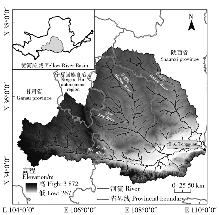
1 研究区概况渭河流域(图 1)的渭河发源于甘肃省渭源县鸟鼠山,干流总长度为818 km,自西向东流经甘肃、宁夏、陕西等省(自治区),最终于陕西省潼关县汇入黄河,流域总面积约为13.5万km2。流域内地形差异明显,自西向东高程逐渐降低,西为黄土丘陵沟壑区,东为关中平原区,南靠秦岭山脉,北有六盘山。气候属于典型的大陆性气候,冬季寒冷干燥,夏季高温多雨,且降雨季节分配不均。

|
图 1 研究区渭河流域 Fig. 1 Weihe River Basin of the study area |
本研究所需的数据主要包括气象、土壤、植被覆盖和土地利用等数据,表 1列出了相关基础数据的描述及来源。
| 表 1 基础数据描述及来源 Tab. 1 Descriptions and sources of basic data |
InVEST模型不仅涵盖了生态系统服务的众多方面,能满足不同功能的评价、模拟和预测需求,而且具有很强的空间化、动态化、可视化等特点[13]。SDR模型以通用土壤流失方程USLE为基础,考虑了地块自身拦截上游沉积物的能力,土壤保持量的计算结果包括土壤侵蚀减少量和泥沙持留量2部分。土壤侵蚀减少量为地块固结土壤不使其产生侵蚀的部分,用潜在土壤侵蚀量与实际土壤侵蚀量的差值表示,而泥沙持留量表示地块对上游侵蚀来沙的截留量,用来沙量与泥沙持留率的乘积表示。土壤保持量的计算过程参考文献[5]。
2.3 模型输入因子的计算考虑到研究区的地理位置及实际情况,笔者采用章文波等[14]建立的日降雨侵蚀力模型计算降雨侵蚀力因子R值,采用张科利等[15]修正的方法计算土壤可蚀性因子K值,采用刘宝元等[16]的方法计算坡度坡长因子LS。采用蔡崇法模型[17]计算耕地、林地、草地等有植被覆盖的土地利用的植被覆盖管理因子C值,水域、建筑用地及未利用地的C值参照文献[18-19]及InVES模型使用手册赋值。水土保持措施因子P指在标准小区,采取水土保持措施与否所产生的土壤侵蚀量之比[20],同一土地利用类型退耕还林前后采用的土壤保持措施大致相同,通过参考相关文献为研究区不同土地利用赋P值[4, 21]。
3 结果与分析 3.1 实际土壤侵蚀量的时空变化1980年和2020年渭河流域土壤侵蚀总量分别为4.18亿和2.78亿t,平均土壤侵蚀模数为3 088.92和2 055.41 t/(km2·a)。总量上来看,退耕还林前后渭河流域实际土壤侵蚀减少1.40亿t,平均土壤侵蚀模数减少1 033.51 t/(km2·a)。
对不同强度的土壤侵蚀进行分区统计(表 2),结果表明渭河流域轻度及以上强度的土壤侵蚀的比例减小,微度侵蚀比例增加。1980年微度侵蚀占侵蚀总量的60.75%,2020年增加至77.62%;轻度侵蚀的比例则由26.42%减小至15.52%,其他强度的侵蚀的比例也均有所减小。
| 表 2 1980年和2020年不同强度土壤侵蚀统计结果 Tab. 2 Statistical results of different soil erosion intensities in 1980 and 2020 |
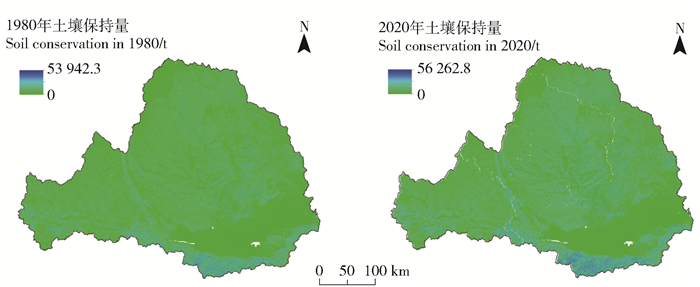
1980年和2020年流域的土壤保持总量分别为48.60亿和53.73亿t,单位面积土壤保持量分别为3万5 980.31 t/km2和4万118.53 t/km2。相较于1980年,2020年土壤保持总量增加5.60亿t,单位面积土壤保持量增加4 138.22 t/(km2·a)。土壤保持总量由2方面组成,一是地块固结土壤不使其产生侵蚀,一是地块截留量上游侵蚀的部分。本研究中,研究期内地块产生的土壤侵蚀量减少6.79亿t,地块拦截上游的土壤持留量减少1.19亿t,说明退耕还林还草工程主要是通过减少土壤侵蚀量来提高土壤保持功能。由土壤保持量的空间分布可知(图 2),渭河流域南岸土壤保持量高于北岸,且相较于1980年,2020年流域土壤保持量高值区分布面积增加。

|
图 2 研究区土壤保持量的空间分布 Fig. 2 Spatial distribution of soil conservation in the study area |
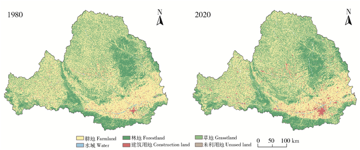
使用1980年和2020年的土地利用代表退耕还林前后渭河流域的土地利用分布状况(图 3)。研究区主要用地类型为耕地、林地和草地,面积之和超过流域总面积的95%。研究期内流域土地利用发生了显著变化:耕地面积净减少4 080.88 km2,草地、建筑用地和草地面积增加,分别增加1 736.13、2 006.88和379.19 km2,水域和未利用地面积变化不显著。

|
图 3 研究区土地利用类型分布图 Fig. 3 Distribution of land use types in the study area |
分区统计各土地利用类型的土壤保持总量及单位面积土壤保持量(表 3)。结果表明,草地的土壤保持量最大,在1980和2020年分别占土壤保持总量的41.13%和42.30%,其次为耕地和林地,未利用地和水域最小。单位面积土壤保持量最大的是林地,其次为草地。相较于1980年,2020年流域总体及各用地类型的土壤保持总量和单位面积土壤保持量均有所提高。
| 表 3 1980年和2020年不同土地利用类型的土壤保持量 Tab. 3 Soil conservation amounts of different land use types in 1980 and 2020 |
将研究区坡度划分为6个等级,统计不同坡度下的植被覆盖度和土壤保持量(表 4)。0~5°的微坡地区土壤保持量最小,单位面积的土壤保持量也最低。>15°~25°的较陡坡土壤保持量最大,占流域土壤保持总量的1/3以上,其次是缓坡、陡坡。单位面积土壤保持量最大的是>35°的急陡坡地区,最小的是0~5°的微坡地区。随着坡度的升高,单位面积土壤保持量逐渐提高,这与区域植被覆盖度的变化趋势相同。1980年,除急陡坡外,其他坡度下的植被覆盖度差别不大,且均处于较低水平;2020年,除微坡和较缓坡外,其余坡度植被覆盖度大幅提升,土壤保持量也显著提高,表明植被覆盖对区域土壤保持功能具有显著的促进作用。
| 表 4 不同坡度下的植被覆盖度及土壤保持量 Tab. 4 Vegetation coverage and soil conservation amount under different slope gradient |
研究结果表明林地和草地的土壤保持能力相对较强,这与多数研究结果一致[22]。林地由于其茂密的冠层及地表大量的枯枝落叶对降水具有截留作用,同时发达的根系能较好地固结土壤,从而使得降雨对地面的侵蚀作用减弱[23]。草地由于分布面积广泛,植被覆盖度较高,故土壤保持总量最大。未利用地的土壤保持能力最低,这是因为其土壤理化性质较差,保水保土作用弱,地表径流系数大,易受强降雨影响产生水土流失[7]。随着退耕还林工程的实施,流域实际土壤侵蚀模数下降,地块能够拦截的上游侵蚀量也减少,各用地类型的土壤保持功能增强。
坡度也是影响土壤保持功能的重要因素。已有研究表明,坡度>15°的地区易发生土壤侵蚀,且坡度越大,侵蚀越严重,必须加以保护[24]。按照国家退耕还林还草政策对坡耕地的要求[25],>25°的坡耕地必须进行退耕,所以在一定范围内植被覆盖度会随着坡度的增加而增大,加之坡度较大的地区人类活动相对较弱,对地面扰动较少,故而坡度较大的地方土壤保持功能较强。坡度较缓的地区多为人口聚集区域,用地类型多为建设用地和耕地,人类活动剧烈扰动,植被较为稀疏,故土壤保持能力相对较弱[12]。
本研究使用Invest模型模拟的土壤侵蚀模数与渭河流域实际土壤侵蚀模数的结果较为吻合[21],但由于模型设置及其简化算法使得模拟结果也存在一些不确定性。例如,模型对USLE方程的过度依赖,但USLE仅代表陆上(细沟/细沟间)侵蚀过程,对其他侵蚀来源包括冲沟侵蚀、河岸侵蚀、山体滑坡或落石造成的土壤流失以及冰川侵蚀的代表性较差[26]。因此,在以这些侵蚀来源为主要侵蚀的地区使用Invest模型时必须进行严格的精度校验。
5 结论1) 退耕还林工程主要通过减少流域土壤侵蚀量来提高土壤保持功能。相较于1980年,2020年渭河流域平均土壤侵蚀模数减少1 033.51 t/(km2·a),微度侵蚀占土壤侵蚀总量的比例由60.75%增加至77.43%,土壤保持总量增加5.60亿t。
2) 不同的土地利用类型中,草地的土壤保持总量最大,占土壤保持总量的40%以上,而林地在单位面积上土壤保持量最大。相较于1980年,2020年各用地类型的土壤保持总量和单位面积土壤保持量均有所提高。
3) 0~5°微坡地区土壤保持量最小,单位面积的土壤保持量也最低,>15°~25°的较陡坡地区土壤保持量最大,其次是缓坡、陡坡。2020年,除微坡和较缓坡外,其余坡度下的土壤保持量随植被覆盖度的增加显著提高。
| [1] |
杨卿, 郎南军, 苏志豪, 等. 土壤退化研究综述[J]. 林业调查规划, 2009, 34(1): 20. YANG Qing, LANG Nanjun, SU Zhihao, et al. Summary of study on study soil degradation[J]. Forest Inventory and Planning, 2009, 34(1): 20. |
| [2] |
柯奇画, 张科利. 基于文献计量的中国水土流失尺度效应研究进展[J]. 生态环境学报, 2022, 31(7): 1489. KE Qihua, ZHANG Keli. Scale effect on water and soil loss in China: A bibliometric analysis[J]. Ecology and Environmental Sciences, 2022, 31(7): 1489. |
| [3] |
刘月, 赵文武, 贾立志. 土壤保持服务: 概念、评估与展望[J]. 生态学报, 2019, 39(2): 432. LIU Yue, ZHAO Wenwu, JIA Lizhi. Soil conservation service: Concept, assessment, and outlook[J]. Acta Ecologica Sinica, 2019, 39(2): 432. |
| [4] |
张徐, 李云霞, 吕春娟, 等. 基于InVEST模型的生态系统服务功能应用研究进展[J]. 生态科学, 2022, 41(1): 237. ZHANG Xu, LI Yunxia, LÜ Chunjuan, et al. Research progress on application of ecosystem service functions based on InVEST model[J]. Ecological Science, 2022, 41(1): 237. |
| [5] |
陈童尧, 贾燕锋, 王佳楠, 等. 基于InVEST模型的祁连山国家级自然保护区土壤保持现状与功能[J]. 干旱区研究, 2020, 37(1): 150. CHEN Tongyao, JIA Yanfeng, WANG Jianan, et al. Current situation and function of soil conservation in national nature reserves in the Qilian Mountains based on InVEST model[J]. Arid Zone Research, 2020, 37(1): 150. |
| [6] |
BOUGUERRA S, JABARI S, TARHOUNI J. Spatiotemporal analysis of landscape patterns and its effect on soil loss in the Ramel River basin, Tunisia[J]. Soil and Water Research, 2021, 45(16): 39. |
| [7] |
ANESEYEE A B, ELIAS E, SOROMESSA T, et al. Land use/land cover change effect on soil erosion and sediment delivery in the Winike watershed, Omo Gibe Basin, Ethiopia[J]. Science of the Total Environment, 2020, 728(1): 1. |
| [8] |
赵雪雁, 马平易, 李文青, 等. 黄土高原生态系统服务供需关系的时空变化[J]. 地理学报, 2021, 76(11): 2780. ZHAO Xueyan, MA Pingyi, LI Wenqing, et al. Spatiotemporal changes of supply and demand relationships of ecosystem services in the Loess Plateau[J]. Acta Geographica Sinica, 2021, 76(11): 2780. |
| [9] |
刘孟竹, 张红娟, 任贺宇, 等. 退耕还林背景下北方农牧交错带土壤保持功能时空变化[J]. 水土保持研究, 2021, 28(5): 172. LIU Mengzhu, ZHANG Hongjuan, REN Heyu, et al. Spatiotemporal variations of the soil conservation in the agro-pastoral ecotone of northern China under Grain for Green program[J]. Research of Soil and Water Conservation, 2021, 28(5): 172. |
| [10] |
FU Bojie, WANG Shuai, LIU Yu, et al. Hydro-geomorphic ecosystem responses to natural and anthropogenic changes in the Loess Plateau of China[J]. Annual Review of Earth and Planetary Sciences, 2017, 45: 223. DOI:10.1146/annurev-earth-063016-020552 |
| [11] |
刘国彬, 上官周平, 姚文艺, 等. 黄土高原生态工程的生态成效[J]. 中国科学院院刊, 2017, 32(1): 11. LIU Guobin, SHANGGUAN Zhouping, YAO Wenyi, et al. Ecological effects of soil conservation in Loess Plateau[J]. Bulletin of Chinese Academy of Sciences, 2017, 32(1): 11. |
| [12] |
穆兴民, 李朋飞, 高鹏, 等. 土壤侵蚀模型在黄土高原的应用述评[J]. 人民黄河, 2016, 38(10): 100. MU Xingmin, LI Pengfei, GAO Peng, et al. Analysis of dynamic change of soil and water loss in the middle Yellow River Basin[J]. Yellow River, 2016, 38(10): 100. |
| [13] |
唐尧, 祝炜平, 张慧, 等. InVEST模型原理及其应用研究进展[J]. 生态科学, 2015, 34(3): 204. TANG Yao, ZHU Weiping, ZHANG Hui, et al. A review on principle and application of the InVEST model[J]. Ecological Science, 2015, 34(3): 204. |
| [14] |
章文波, 谢云, 刘宝元. 利用日雨量计算降雨侵蚀力的方法研究[J]. 地理科学, 2002, 22(6): 705. ZAHNG Wenbo, XIE Yun, LIU Baoyuan. Rainfall erosivity estimation using daily rainfall amounts[J]. Scientia Geographica Sinica, 2002, 22(6): 705. |
| [15] |
张科利, 彭文英, 杨红丽. 中国土壤可蚀性值及其估算[J]. 土壤学报, 2007, 44(1): 7. ZHANG Keli, PENG Wenying, YANG Hongli. Soil erodibility and its estimation for agricultural soil in China[J]. Acta Pedologica Sinica, 2007, 44(1): 7. |
| [16] |
LIU B Y, NEARING M A, RISSE L M. Slope length effects on soil loss for steep slopes[J]. Soil Science Society of America Journal, 2000, 64(5): 1759. DOI:10.2136/sssaj2000.6451759x |
| [17] |
蔡崇法, 丁树文, 史志华, 等. 应用USLE模型与地理信息系统IDRISI预测小流域土壤侵蚀量的研究[J]. 水土保持学报, 2000, 14(2): 19. CAI Chongfa, DING Shuwen, SHI Zhihua, et al. Study of applying USLE and geographical information system IDRISI to predict soil erosion in small watershed[J]. Journal of Soil and Water Conservation, 2000, 14(2): 19. |
| [18] |
许丁雪, 吴芳, 何立环, 等. 土地利用变化对生态系统服务的影响: 以张家口—承德地区为例[J]. 生态学报, 2019, 39(20): 7493. XU Dingxue, WU Fang, HE Lihuan, et al. Impact of land use change on ecosystem services: Case study of the Zhangjiakou-Chengde area[J]. Acta Ecologica Sinica, 2019, 39(20): 7493. |
| [19] |
张薇, 王凤春, 万虹麟, 等. 基于InVEST模型的土壤保持服务时空变化及其影响因素分析: 以密云水库上游流域河北张承地区为例[J]. 地球物理学进展, 2022, 37(7): 2339. ZHANG Wei, WANG Fengchun, WAN Honglin, et al. Spatiotemporal variations and influencing factors of soil conservation service based on InVEST Model: A case study of Miyun Reservoir upstream basin of Zhangcheng area in Hebei[J]. Progress in Geophysics, 2022, 37(7): 2339. |
| [20] |
冯凌, 张红, 刘光磊, 等. 汾河源头地区土壤侵蚀时空变化及其空间自相关分析[J]. 水土保持通报, 2016, 36(1): 93. FENG Ling, ZHANG Hong, LIU Guanglei, et al. Spatio-temporal variations of soil erosion in the source of Fenhe river watershed[J]. Bulletin of Soil and Water Conservation, 2016, 36(1): 93. |
| [21] |
贾磊, 姚顺波, 邓元杰, 等. 渭河流域土壤侵蚀时空特征及其地理探测[J]. 生态与农村环境学报, 2021, 37(3): 305. JIA Lei, YAO Shunbo, DENG Yuanjie, et al. Temporal and spatiaI characteristics of soil erosion risk in Weihe River Basin and its geographical exploration[J]. Journal of Ecology and Rural Environment, 2021, 37(3): 305. |
| [22] |
陈万旭, 梁加乐, 卞娇娇, 等. 黄河流域景观破碎化对土壤保持服务影响研究[J]. 地理科学, 2022, 42(4): 589. CHEN Wanxu, LIANG Jiale, BIAN Jiaojiao, et al. Impact of landscape fragmentation on soil conservation services in the Yellow River Basin[J]. Scientia Geographica Sinica, 2022, 42(4): 589. |
| [23] |
SCHWAIGER F, POSCHENRIEDER W, BIBER P, et al. Ecosystem service trade-offs for adaptive forest management[J]. Ecosystem Services, 2019, 39: 100993. DOI:10.1016/j.ecoser.2019.100993 |
| [24] |
白杨, 郑华, 庄长伟, 等. 白洋淀流域生态系统服务评估及其调控[J]. 生态学报, 2013, 33(3): 711. BAI Yang, ZHENG Hua, ZHAUNG Changwei, et al. Ecosystem services valuation and its regulation in Baiyangdian baisn: Based on InVEST model[J]. Acta Ecologica Sinica, 2013, 33(3): 711. |
| [25] |
吴吉东, 李宁, 牛定炜, 等. 退耕对粮食生产灾情的间接影响分析: 以甘肃省定西市安定区为例[J]. 自然灾害学报, 2008, 17(2): 8. WU Jidong, LI Ning, NIU Dingwei, et al. Indirect effect of returning farmland to forest on disaster situation of grain production: A case study on Anding district of Dingxi city[J]. Journal of Natural Disasters, 2008, 17(2): 8. |
| [26] |
陈云明, 刘国彬, 郑粉莉, 等. RUSLE侵蚀模型的应用及进展[J]. 水土保持研究, 2004, 11(4): 80. CHEN Yunming, LIU Guobin, ZHENG Fenli, et al. Proceeding and application on soil erosion model of RUSLE[J]. Research of Soil and Water Conservation, 2004, 11(4): 80. |