-
项目名称
- 国家自然科学基金“中国东南和西北地区丹霞地貌陡坡上洞穴成因对比研究”(42361002);江西省自然科学基金青年基金“鄱阳湖湖岸沙丘的移动形态演变及其风沙危害研究”(20202BABL213028);东华理工大学博士启动基金(DHBK2019052)
-
第一作者简介
- 杨德慧(1998—), 女,硕士研究生。主要研究方向:风沙地貌防治。E-mail:761759042@qq.com
-
通信作者简介
- 吴汪洋(1988—),男,博士,讲师。主要研究方向:水土保持与荒漠化防治。E-mail:bnuwwy@163.com
-
文章历史
-
收稿日期:2023-04-23
修回日期:2023-09-11
风对土地沙漠化和风沙灾害具有重要影响,区域起沙风可以搬运地表沙物质,风速和风频的大小影响着风沙活动强度和沙粒运输方式,风向控制着区域沙粒移动方向。因此对区域风况和风能环境研究有助于了解区域的风沙活动规律。输沙势是衡量区域风沙活动强度的指标[1],国内外众多学者基于风况和输沙势对沙漠地区的风沙活动开展了广泛的研究。其中,Fryberger等[2]提出输沙势计算公式,Hereher等[3]和Al-Awadhi等[4]对全球典型沙漠化地区的输沙势进行评估。国内学者对输沙势的研究集中于在中国北方和青藏高原沙漠化地区[5-7],如张克存等[8]和张正偲等[9]对输沙势和输沙量的关系进行研究。鄱阳湖沙地及沙山的形成有别于北方沙漠。该地区沙化地是水蚀和风蚀共同作用的结果[10],但近年来学者们对鄱阳湖沙地的固沙效益[11]和水蚀方面研究较集中,对沙地风蚀的研究匮乏。因此加强对鄱阳湖风况和风沙环境的研究有助于了解鄱阳湖沙地侵蚀规律,对沙化土地治沙防沙具有重要意义。
鄱阳湖沙地是典型的南方湖滨沙化土地,沿岸不同部位的沙化土地在规模和扩展速度方面存在差异,加上采砂场等基础建设的开发,加剧了该区域的水土流失和土地退化。因此,本文选取鄱阳湖沿岸2005—2020年的气象数据,分析沿岸沙地风况特征和输沙势时空变化特征,从而指导鄱阳湖防沙的重点区域,遏制风沙危害,防治水土流失,提升水土保持功能,促进鄱阳湖生态环境的改善。
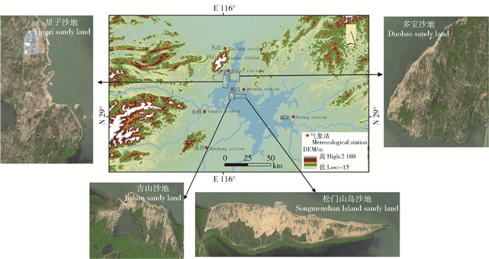
1 研究区概况鄱阳湖位于江西省北部,长江中下游南岸,其沙源和水源主要源自赣江、抚河、饶河、信江、修水等5河,属亚热带湿润气候,夏季高温多雨,干湿季分明,2005—2020年均气温12.47~18.80℃,最高气温41℃,全年无霜期241~304 d,年降水量928.10~2 956.60 mm,集中在3—6月。鄱阳湖沙地类型主要有流动沙丘、半固定沙丘、固定沙丘、湖岸沙山,总沙化土地面积3万8 900 hm2,其中固定沙丘6 700 hm2,半固定沙丘1万3 600 hm2,流动沙丘8 500 hm2,主要分布在星子沙地和东港河沙地、松门山岛沙地,厚田沙漠,定山村、沙湖村、南矶山等地也有零星分布(图 1)。植被主要有湿地松(Pinus elliottii)、蔓荆(Vitex trifolia)、狗牙根(Cynodon dactylon)、胡枝子(Lespedeza bicolor)等固沙植物。

|
图 1 鄱阳湖主要沙地及气象站位置 Fig. 1 Location map of main sandy lands and meteorological stations of Poyang Lake |
鄱阳湖沿岸的7个基准气象站:九江(E 116°00′,N 29°44′)、庐山(E 115°59′,N 29°35′)、星子(E 116°03′,N 29°27′)、永修(E 115°49′,N 29°03′)、都昌(E 116°12′,N 29°16′)、鄱阳(E 116°41′,N 29°00′)、南昌(E 115°55′,N 28°36′)(图 1),海拔分别为:36.1、1 164.5、37.1、36.6、35.5、40.1和46.9 m。气象站的风况、气温、降水等数据来源于中国气象局,统计时间段为2005年1月1日到2020年12月31日,统计间精度为时。
对研究区16 a的平均风速(Va)、最大风速(Vmax)、起沙风风向和起沙风风频(Fs)进行统计。输沙势可评价风能环境,其计算公式[2]为:
| $ D_{\mathrm{p}}=V^2\left(V V_t\right) t \quad ; $ | (1) |
| $ C_{\mathrm{r}}=\frac{R_{\mathrm{DP}}}{D_{\mathrm{p}}} 。$ | (2) |
式中:Dp为输沙势(drift potential,DP),VU低风能环境(<200 VU)、中风能环境(≥200~≤400 VU)、高风能环境(>400 VU);V为t时间内所有大于或等于临界起沙风的风速,m/s;Vt为临界起沙风速,6 m/s[12];t为起沙风作用时间占总观测时间的比例,%;RDP为合成输沙势(resultant drift potential,RDP),VU。Cr为风向变率,指区域风向组合情况[13],分为:大比率(<0.3),复合风况、中比率(≥0.3~≤0.8),钝双峰或锐双峰、小比率(>0.8),单峰或窄单峰。
3 结果与分析 3.1 全年风况特征 3.1.1 风速变化特征由表 1可得,鄱阳湖沿岸各站点Va与Vmax空间变化相似,西北高于中部和南部,西北部的庐山站Va最高(3.71 m/s),东南部的鄱阳站最低(1.97 m/s)。季节变化中,除鄱阳站Va和Vmax在夏季较大,庐山站春季的Va较大之外,其他气象站:Va秋、冬季较大和Vmax春季最高。表明研究区春季极大风天气多,秋、冬两季Va较高,夏季风速最低。
| 表 1 2005—2020年鄱阳湖沿岸各站点的Va、Vmax、V、Fs Tab. 1 Va, Vmax, V and Fs of meteorological stations along Poyang Lake from 2005 to 2020 |
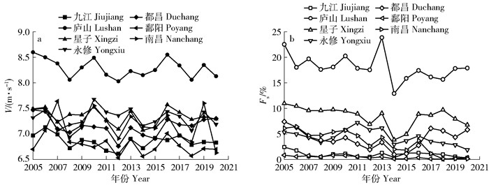
由表 1可得,鄱阳湖沿岸各站点V和Fs在空间上,庐山和星子为高值区,九江和鄱阳为低值区,在季节变化中,V在春季时最高,Fs除庐山和鄱阳的春季最高外,其余各站均在冬季最高。由图 2可得,2005—2006年间各站的V波动变化显著,整体减小,庐山、星子和永修偏高,鄱阳和九江偏低。相比V,Fs年际变化波动范围较小,总体下降,庐山与星子Fs最高。

|
图 2 2005—2020年鄱阳湖沿岸各气象站V和Fs年际变化 Fig. 2 Interannual variation of V and Fs of meteorological stations along Poyang Lake from 2005 to 2020 |
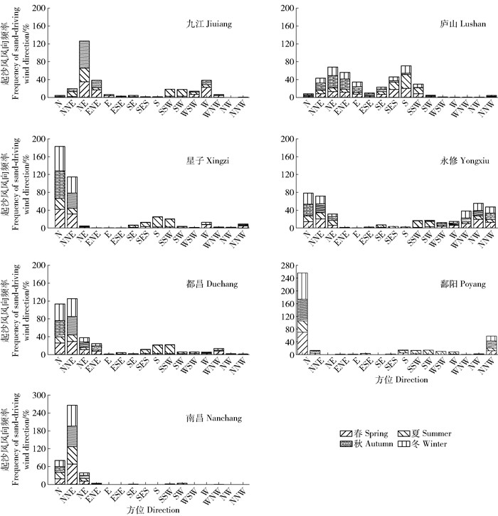
由图 3可得,风向以北为0,按顺时针取方位,下角N、E、S、W等代表 16个风向方位。除庐山站起沙风向多变以外,其余站的起沙风均集中在WN-N-NE,鄱阳湖沿岸的Fs整体呈北部大于东部和南部的空间特征;除鄱阳站和南昌站外,其余站点秋冬季的Fs高于春夏季,秋冬季盛行的N-NE风是鄱阳湖沙地产生风沙活动最强烈的时段和来源。

|
N为北、NNE为北北东、NE为东北、ENE为东东北、E为东、ESE为东东南、SE为东南、SES为南东南、S为南、SSW为南西南、SW为西南、WSW为西西南、W为西、WNW为西西北、NW为西北、NNW为北西北。 N: North. NNE: North northeast. NE: Northeast. ENE: East northeast. E: East. ESE: East southeast. SE: Southeast. SES: South southeast. S: South. SSW: South southwest. SW: Southwest. WSW: West southwest. W: West. WNW: West northwest. NW: Northwest. NNW: North northwest. 图 3 鄱阳湖沿岸各气象站年均起沙风风向频率 Fig. 3 Annual frequency of sand-driving wind direction at meteorological stations along Poyang Lake |
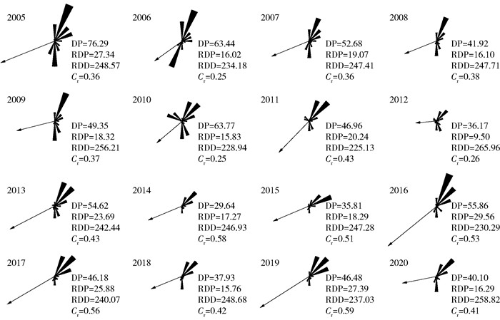
由图 4可得,2005—2020年鄱阳湖沿岸各站点的DP年际变化波动大,整体呈减小趋势,分别在2010、2013、2016和2019年出现波峰(46.68<VU<63.77)。各站点年均DP较低,为低风能环境,DP在NNE(18.32 VU)、NE(12.85 VU)和ENE方向较高(累计DP占全年的40.00%~68.00%)。总DP在2005年达到峰值(76.29 VU),2014年为谷值(29.64 VU)。RDP分别在2005、2016和2019年较高(27.34~29.56 VU),2012年为谷值(9.50 VU),2011年之后RDP与DP变化趋势相同。在奇数年份较大;各站点的合成输沙方向(resultant drift direction,RDD)指向SW-W;Cr除2006、2010和2012年为小比率外,其余年份均为中比率。除2006、2010和2012年为小比率的风向变率之外之外(Cr<0.3),其余年份均表现出较强的东北输沙源特性(0.3<Cr<0.8)。

|
DP: Drift potential, VU. RDP: Resultant drift potential, VU. RDD: Resultant drift direction, (°). Cr: Wind direction variability. The same below. 图 4 2005—2020年鄱阳湖沿岸DP年际变化 Fig. 4 Interannual variation of DP along Poyang Lake from 2005 to 2020 |
季节差异上,DP大小为春季>冬季>秋季>夏季(图 5)。RDP在秋冬季较高,春季多方向起风,秋季和冬季风向单一,四季均为低风能环境。各季RDD指向SSW-W,表明整体沙物质向西南方向输移,与年际RDD指向相似。Cr在春季为中比率,南风和东北风较强,其他季节属高比率,以东北风为主。

|
图 5 鄱阳湖沿岸DP季节变化 Fig. 5 Seasonal variation of DP along Poyang Lake |
由图 6a、b可得,DP与RDP均以庐山和星子较大,九江和鄱阳最小。RDP平均值大小为:庐山>星子>永修>南昌>都昌>九江>鄱阳,庐山绝大部分时间处于中风能环境,而其他6站16 a间均为低风能环境。2005—2020年鄱阳湖沿岸各站点DP呈波动下降趋势,风力侵蚀作用逐渐减弱,波峰与波谷的年份相差2~3 a,其中庐山下降幅度最大,鄱阳和九江下降幅度最小,区域差异显著,呈北高南低、西高东低的空间特征,西北部是风沙活动较强的区域。

|
图 6 2005—2020年鄱阳湖沿岸气象站DP、RDP、Cr、RDD Fig. 6 DP, RDP, Cr, and RDD of meteorological stations along Poyang Lake from 2005 to 2020 |
由图 6c、d可得,鄱阳湖沿岸的Cr空间异质性显著。庐山为中比率;星子和永修既有中比率又有大比率;都昌、九江、南昌、鄱阳Cr波动范围较大,而鄱阳和南昌风况较单一,以大比率为主。整体上,鄱阳湖东部和南部地区的风况环境稳定,输沙方向集中,西部和北部出现两个近似相对方向的输沙现象,输沙具有一定往复性。
4 讨论时间尺度上,RDP与鄱阳湖沙地面积变化相似(表 2),整体逐年减少。年内变化中,冬季的RDP较高,“旱季”和“风季”同期促使冬季的风沙活动强,尽管季风对夏季的影响较大,但夏季植被盖度高,降水量大,削弱了起沙风速,导致Fs较低。空间尺度上,鄱阳湖沙地DP北高南低,西高东低,这与地形和气候有关。西北部庐山站海拔高,风速比平地大;星子站位于鄱阳湖狭管处,在狭管效应影响下风速增加;九江站位于狭管周边,风速降幅大;鄱阳站位于湖面开阔的东南部,远离狭道,风速降低快[14]。DP空间变化与风沙活动变化一致,如DP与沙地面积空间分布情况相符。庐山和星子DP最高,在附近有面积最大的星子沙岭和多宝沙山,分别为12.52和14.42 km2;鄱阳站DP最低,沙地面积最小,裸沙地较少。
| 表 2 鄱阳湖沙地面积[15]与RDP的变化特征 Tab. 2 Variation characteristics of sandy land area[15] and RDP in Poyang Lake |
风况影响风沙地貌发育,在一定程度上决定沙丘形态[16]。沙丘的发育整体呈NE-SW延伸,与RDD大体一致,表明东北风对沙山的影响较大。星子沙地迎风坡发育风蚀槽与风蚀垄,呈线型延伸,平行排列(图 7a),走向多为30°,与主风向一致[17],灌丛沙堆顶部到逐渐尖灭的尾端可指示起沙风的方向[18],走向与RDD一致(图 7b);松门山岛沙地呈东西走向,在东部主要发育南北走向的风蚀垄,沙丘表面形成的沙波纹(图 7c),可判断出松门山岛冬季风向为北风;吉山沙地东部发育三种类型的抛物线沙丘,北至南依次为短臂高脊型、长臂中脊型和中臂低脊型[19],顺风向排列。

|
图 7 鄱阳湖沙地风沙地貌类型 Fig. 7 Types of aeolian sand landform in Poyang Lake sandy land |
2005—2020年鄱阳湖沿岸Fs冬季最高,起沙风风速波动较小。DP变化波动大,整体呈减小趋势,奇数年份较大,在春季最高,而RDP在冬季最高。DP和RDP均呈北高南低,西高东低的空间特征,DP与RDP均以庐山最大。RDD以偏西南为主,起沙风风向和DP以N和NNE为主。南昌和永修Cr为大比率,其他5站为中比率。
RDP与沙地面积同期增大或减小,高值区分布在沙地面积较大处。RDD以西南为主,与鄱阳湖沙地风蚀地貌发育规律相符合。应重视星子、都昌、永修的沙化防治。
| [1] |
罗凤敏, 高君亮, 辛智鸣, 等. 乌兰布和沙漠东北缘起沙风风况及输沙特征[J]. 农业工程学报, 2019, 35(4): 145. LUO Fengmin, GAO Junliang, XIN Zhiming, et al. Characteristics of sand-driving wind regime and sediment transport in northeast edge of Ulan Buh Desert[J]. Transactions of the CSAE, 2019, 35(4): 145. |
| [2] |
FRYBERGER S G, DEAN G. Dune forms and wind regime[M]//McKee E D. A Study of Global Sand Seas. Hawaii, USA: University Press of the Pacific, 1979: 132.
|
| [3] |
HEREHER M E. Assessment of sand drift potential along the Nile Valley and Delta using climatic and satellite data[J]. Applied Geography, 2014(55): 39. |
| [4] |
AL-AWADHI J M, AL-HELAL A, AL-ENEZI A. Sand drift potential in the desert of Kuwait[J]. Journal of Arid Environments, 2005, 63(2): 425. DOI:10.1016/j.jaridenv.2005.03.011 |
| [5] |
王永胜, 杨文斌, 李永华, 等. 库姆塔格沙漠东缘荒漠绿洲过渡带风况及输沙势[J]. 干旱区资源与环境, 2015, 29(1): 140. WANG Yongsheng, YANG Wenbin, LI Yonghua, et al. Wind regime and resultant sand-transporting potential in the desert-oasis ecotone in the eastern marginal zone of the Kumtag Desert[J]. Journal of Arid Land Resources and Environment, 2015, 29(1): 140. |
| [6] |
李红军, 何清, 杨青. 近40a新疆输沙势的分析[J]. 中国沙漠, 2004, 24(6): 706. LI Hongjun, HE Qing, YANG Qing. Analysis of drift potential in Xinjiang in recent 40 years[J]. Journal of Desert Research, 2004, 24(6): 706. |
| [7] |
汪海娇, 田丽慧, 张登山, 等. 青海湖东岸沙地风沙活动特征[J]. 中国沙漠, 2020, 40(1): 49. WANG Haijiao, TIAN Lihui, ZHANG Dengshan, et al. Characteristics of blown sand activities in sandy land on the eastern shore of the Qinghai Lake of China[J]. Journal of Desert Research, 2020, 40(1): 49. |
| [8] |
张克存, 屈建军, 俎瑞平, 等. 腾格里沙漠东南缘风沙活动动力条件分析: 以沙坡头地区为例[J]. 干旱区地理, 2008, 31(5): 643. ZHANG Kecun, QU Jianjun, ZU Ruiping, et al. Dynamical characteristics of wind-blown sand activities at the southeast edge of Tengger Desert: A case study at Shapotou Region[J]. Arid Land Geography, 2008, 31(5): 643. |
| [9] |
张正偲, 董治宝, 赵爱国, 等. 输沙量与输沙势的关系[J]. 中国沙漠, 2011, 30(4): 824. ZHANG Zhengsi, DONG Zhibao, ZHAO Aiguo, et al. Relationship between sand transport and sand drift potential[J]. Journal of Desert Research, 2011, 30(4): 824. |
| [10] |
丁明军, 郑林, 聂勇. 鄱阳湖沙山地区沙化土地特征及成因分析[J]. 水土保持通报, 2010, 30(2): 159. DING Mingjun, ZHENG Lin, NIE Yong. Characteristics and driving factors of sandy desertification in the sandy hill area of Poyang Lake[J]. Bulletin of Soil and Water Conservation, 2010, 30(2): 159. |
| [11] |
左长清, 杨洁, 李相玺. 江西省鄱阳湖湖滨沙地蔓荆的固沙效益[J]. 中国水土保持科学, 2003, 1(2): 38. ZUO Changqing, YANG Jie, LI Xiangxi. Sand fixation benefits of Vitex trifolia L. in bank land of Poyang Lake in Jiangxi[J]. Science of Soil and Water Conservation, 2003, 1(2): 38. |
| [12] |
党淑青. 沙岭沙山风蚀地貌特征与成因分析[D]. 南京: 南京大学, 2013: 28. DANG Shuqing, Characteristics and formation of the wind eroded landforms on Shaling Sand Hills[D]. Nanjing: Nanjing University, 2013: 28. |
| [13] |
俎瑞平, 张克存, 屈建军, 等. 塔克拉玛干沙漠风况特征研究[J]. 干旱区地理, 2005, 28(2): 167. ZU Ruiping, ZHANG Kecun, QU Jianjun, et al. Study on wind regime characteristics in the Taklimakan Desert[J]. Arid Land Geography, 2005, 28(2): 167. |
| [14] |
贺志明, 聂秋生, 刘熙明, 等. 鄱阳湖区近地层风能资源特征研究[J]. 资源科学, 2011, 33(1): 184. HE Zhiming, NIE Qiusheng, LIU Ximing, et al. Surface-layer wind energy resources over the Poyang Lake area[J]. Resources Science, 2011, 33(1): 184. |
| [15] |
李成梁, 况润元, 吴倩雯. 近十年鄱阳湖枯季湿地信息提取及变化监测分析[J]. 江西理工大学学报, 2019, 40(3): 30. LI Chengliang, KUANG Runyuan, WU Qianwen. Analysis of information extraction and monitoring of Poyang Lake wetland during low flow period in recent ten years[J]. Journal of Jiangxi University of Science and Technology, 2019, 40(3): 30. |
| [16] |
田敏, 钱广强, 杨转玲, 等. 柴达木盆地东北部哈勒腾河流域风况特征及其对风沙地貌发育的影响[J]. 中国沙漠, 2021, 41(1): 1. TIAN Min, QIAN Guangqiang, YANG Zhuanling, et al. Characteristics of wind regime and its influences on the development of aeolian landforms in the Haertenghe Reach, northeastern Qaidam Basin, China[J]. Journal of Desert Research, 2021, 41(1): 1. |
| [17] |
韩志勇, 李徐生, 张兆干, 等. 鄱阳湖湖滨沙山垄状地形的成因[J]. 地理学报, 2010, 65(3): 331. HAN Zhiyong, LI Xusheng, ZHANG Zhaogan, et al. Genesis of ridgelike landform on sand hill on the shore of the Poyang Lake[J]. Acta Geographica Sinica, 2010, 65(3): 331. |
| [18] |
邹学勇. 中国亚热带湿润地区风沙地貌的研究: 以江西省新建县厚田为例[J]. 中国沙漠, 1990, 10(2): 46. ZOU Xueyong. A study on aeolian sand in humid subtropical zone in China: Taking Houtian area in Xinjian county, Jiangxi province as an example[J]. Journal of Desert Research, 1990, 10(2): 46. |
| [19] |
任翌成. 自然和人为因素影响下鄱阳湖滨抛物线沙丘的发育模式[D]. 南京: 南京大学, 2020: 58. REN Yicheng. Natural and human factors influence the formation of parabolic dunes on the shore of Poyang Lake[D]. Nanjing: Nanjing University, 2020: 58. |
 2024, Vol. 22
