-
项目名称
- 国家自然科学基金重点项目"西南黄壤区不同尺度土壤侵蚀与泥沙运移规律耦合关系"(41730748)
-
第一作者简介
- 柯奇画(1993-), 女, 博士。主要研究方向: 土壤侵蚀与水土保持。E-mail: qihuake@mail.bnu.edu.cn
-
通信作者简介
- 张科利(1962-), 男, 博士, 教授。主要研究方向: 土壤侵蚀与水土保持。E-mail: keli@bnu.edu.cn
-
文章历史
-
收稿日期:2021-08-31
修回日期:2022-06-24
尺度问题对于地表过程及水土流失研究具有重要意义。径流作为陆地上重要的水文现象,是水分循环和水量平衡的基本要素,也是土壤侵蚀的重要营力和泥沙输移的主要载体。径流是一个具有时空变化的动态概念,也是一个包括水、沙和溶质运移的多相流过程;因此,径流尺度效应在狭义上指径流模数随时空尺度的变化规律,而在广义上则是一个同时涉及水、沙和溶质的多相流随时空尺度的变化规律的问题。作为当今地学界和水文学界研究的前沿与热点问题之一,径流尺度效应问题近年来受到众多研究者的广泛关注。由于水文现象及其影响因素的空间异质性及时空变异性,在某一尺度上观测到的特征或规律在另一尺度上的表现可能不同[1]。小尺度上的径流结果或产流模式应用到大时空尺度上时很困难,而通过大尺度观测到的水文数据推算无资料的小尺度径流特征的难度也很大;且由于区域的差异性,一个地区的研究结果在应用到其他差异性较大的地区时也可能存在困难。径流尺度效应问题不仅是一个科学挑战,而且还是水文预报、水利工程防洪设计和水土流失治理中需要面临的实际问题[2]。现有的综述性文章缺乏对径流尺度效应研究各方面整体进展和分区概况的定量分析和系统整理。笔者运用文献分析法,对我国径流尺度效应问题目前已有的相关文献资料进行计量统计,旨在为准确把握我国径流尺度效应研究进展提供基础数据,为我国水文水资源和水土保持领域的研究和工作提供参考。
1 资料来源与分析方法所选取样本文献来自国内外6大权威期刊论文数据库。其中,中文数据库包括知网、万方和维普,英文数据库包括Web of Science、Scopus和ProQuest。通过高级检索式,对每个数据库中与陆面水文和径流时空尺度问题有关的文献进行检索,检索日期为2021年4月30日,所有文献发表时间在1979年至2021年4月范围内。其中,以知网为例的检索式为:题目=((‘径流’+‘产流’+‘水文’+ ‘洪水’)*(‘时间尺度’+‘空间尺度’+‘时空尺度’+‘不同尺度’+‘尺度影响’+‘尺度效应’+‘尺度问题’+‘多尺度’+‘尺度转换’))。本次文献分析所涉及的主要研究领域有地理学、农学、地球科学、环境科学、物理学、水利工程、水资源学。
将以上6个数据库中搜索到的文献题录信息下载并导入Excel中,去除重复和无关条目,最终得到362篇中文文献和155篇英文文献的题录信息,共517条文献数据。每一条文献数据包括题目、关键词、摘要、作者、机构、发表年份等信息。基于以上题录信息,通过词频分析法对目标字词出现的频率进行计数统计,以此反映各关键词在领域内的研究热度和整体的研究概况。
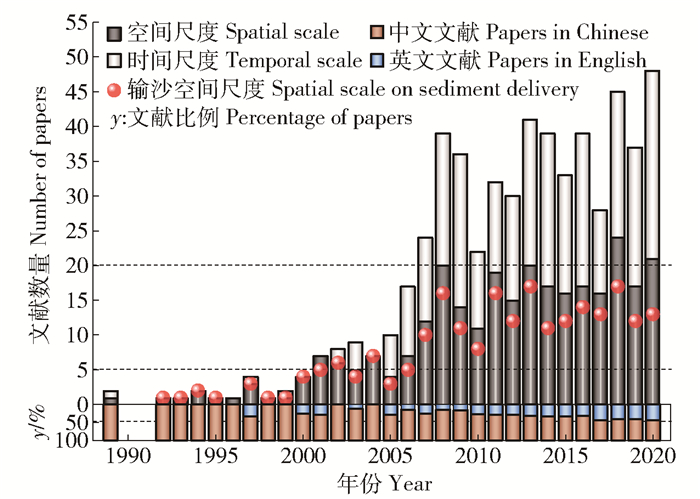
2 文献统计结果与分析 2.1 时间历程我国最早研究径流尺度效应的文献[3]发表于1989年,探讨暴雨洪水及水资源旱涝丰枯的时空尺度问题;之后的研究以2000和2006年为分界大致分为3个阶段(图 1)。早期阶段(1989—2000年),研究发展缓慢,年均产出文献仅1篇。早期研究大致可分为2方面:一方面是探讨径流输沙的空间尺度效应问题[4];另一方面是探讨不同流域尺度间产流模式和洪水过程的差异[3, 5]。21世纪开始(2001—2006年),研究进入快速发展阶段,年均文献产出近9篇;此阶段关于径流时间尺度效应的研究也开始发展起来,且多是关于河川径流过程的多时间尺度周期性变化规律的研究[6-7]。进入稳定发展阶段(2007年至今),年均文献产出高达31篇;此阶段时间尺度也成为径流尺度效应研究中不可忽视的主要内容,融雪径流[8]、冰川径流[9]和水文连通性[10]的尺度效应研究开始出现,纯粹关注径流的空间尺度效应研究[11]也迅速发展起来。
|
图 1 文献数量随时间变化的过程 Fig. 1 Trend of published papers through time |
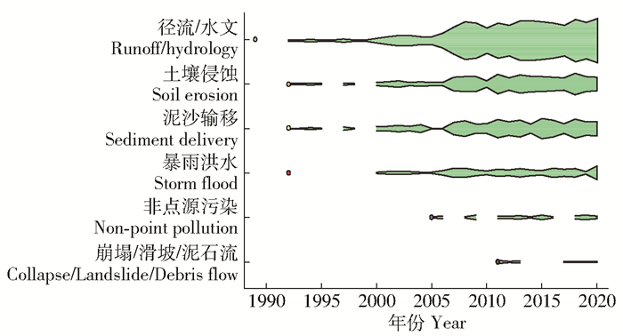
径流过程通常涉及到次降雨过程中的入渗产流、土壤侵蚀、泥沙和养分运移等问题。从研究主题来看,国内关于径流尺度效应研究的文献以径流和水文过程为主题的居多,其次是土壤侵蚀和泥沙输移为主题的研究;关注暴雨洪水的研究较少,也少量存在与径流输沙过程有关的非点源污染、崩塌/滑坡/泥石流等形式的主题研究。从主题发展历程(图 2)来看,对径流和水文过程的研究最早,始于1989年[3];其次是土壤侵蚀、泥沙输移和暴雨洪水为主题的研究,始于1992年[11];涉及非点源污染和崩塌/滑坡/泥石流的研究相对较晚,分别始于2005[2]和2011年[12]。在全球气候极端化的背景下,近年来对场次洪水空间尺度效应的研究增多,关于海绵城市建设对暴雨水文调节尺度效应的相关研究也开始出现[13]。
|
图 2 研究主题随时间变化的过程 Fig. 2 Trend of research topics through time |
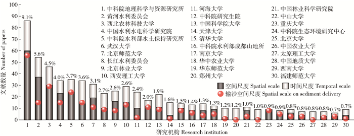
截至目前为止,全国各地共有196所研究机构参与径流尺度效应的相关研究,前30强单位发表的文献合计比例约66%(图 3)。其中,前5强单位依次是:中科院地理科学与资源研究所、黄河水利委员会、西北农林科技大学、中国水利水电科学研究院和中科院水利部水土保持研究所。这5家单位以径流空间尺度效应的相关研究为主,发表的文献占总文献的27%。
|
1: Institute of Geographic Sciences and Natural Resources Research, CAS. 2: Yellow River Conservancy Commission. 3: Northwest A & F University. 4: China Institute of Water Resources and Hydropower Research. 5: Institute of Soil and Water Conservation, CAS & MWR. 6: Wuhan University. 7: Beijing Normal University. 8: Changjiang Water Resources Commission. 9: Beijing Forestry University. 10: Xi′an University of Technology. 11: Hohai University. 12: Graduate University of the Chinese Academy of Sciences. 13: University of Chinese Academy of Sciences. 14: Tianjin University. 15: Tsinghua University. 16: Institute of Mountain Hazards and Environment, CAS & MWR. 17: Nanjing University. 18: Huazhong Agricultural University. 19: East China Normal University. 20: Zhengzhou University. 21: Chinese Academy of Forestry Sciences. 22: Sun Yat-sen University. 23: Chongqing University. 24: Research Center for Eco-Environmental Sciences, CAS. 25: Peking University. 26: China Agricultural University. 27: Taiyuan University of Technology. 28: China University of Geosciences. 29: Southwest University. 30: Fujian Normal University. 图 3 研究机构中前30强单位的文献发表情况 Fig. 3 Publications of top 30 research institutions |
由表 1可知,我国径流尺度效应研究单位和文献发表主要集中于环渤海湾的京津冀鲁辽以及黄河中下游与长江中下游之间的区域,其次是珠江下游地区;台湾和香港也有一些研究机构在关注;宁夏、吉林、青海和西藏地区的研究非常少,而海南和澳门尚无相关研究。
| 表 1 研究机构和文献的地区分布概况 Tab. 1 Regional distributions of research institutions and publications |
从时间尺度(图 4a)来看,国内关于径流尺度效应的研究主要集中在年尺度,其次是次降雨尺度,然后依次是季尺度、月尺度和日尺度。其中,年尺度以年际尺度(1~9 a)为主,而涉及年代际尺度(10~19 a)和数年代际尺度(20~99 a)的研究非常少。

|
Ⅰ: Temporal scale. a: Event. b: Daily. c: Monthly. d: Seasonal. e: Yearly. f: Inter-yearly. g: Inter-decadal. h: Multi-decadal. Ⅱ: Areal spatial scale. a: Slope. b: Watershed. c: Region. d: Mini-plot. e: Plot. f: Mini-watershed. g: Micro/Milli-watershed. h: Meso-watershed. i: Macro-watershed. j: Normal watershed. k: Normal region. l: Macro-region. Ⅲ: Linear spatial scale. a: Slope channel. b: River system. c: Rill. d: Gully. e: Minor gully. f: Branch gully. g: Modern incised valley. h: Ancient incised valley. i: Riverway. j: Tributary. k: Trunk. l: Reservoir and dam. m: Lake. 图 4 不同时间尺度和不同空间尺度的分布概况 Fig. 4 Distributions of different temporal scales and spatial scales |
从面状空间尺度(图 4b)来看,相关研究集中在流域尺度,其次是坡面尺度,而区域尺度的研究较少。由于大多数文献在题录文摘信息中未说明具体汇水面积,因此统计结果显示大多数研究是在普通小区、普通小流域或普通区域尺度上进行的,而涉及微型小区、微型小流域和大区域尺度的研究极少。从流域大小来看,相关研究集中在小流域尺度,而涉及中流域和大流域的研究较少。从线状空间尺度(图 4c)来看,大部分研究与河流相关,而沟道相关研究较少。其中,河流相关研究聚焦于干支流河道,其次与河流所建库坝有关,还有小部分研究关注与河流相连的湖泊。与沟道有关的研究中,按照侵蚀沟的发育程度,涉及细沟的研究较多,其次是支沟,关于毛沟、切沟、冲沟和干沟的研究较少,而浅沟未被提及。
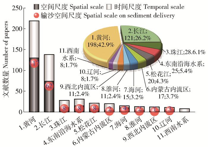
2.5 研究区分布 2.5.1 流域分布如图 5所示,黄河和长江2大流域的研究最多,而后依次是华南的珠江和东南沿海水系(包括港澳台),东北的松花江,华北的内蒙古内流区、海河和淮河;西北内流区、辽河和西南水系相关研究很少,藏北高原内流区更是研究空白区。从文献构成来看,黄河、长江和海河侧重于输沙空间尺度效应的研究,而珠江、松花江、内蒙古内流区、淮河、西北内流区和西南水系的相关研究则侧重于径流时间尺度效应的探讨。
|
1: Yellow River. 2: Yangtze River. 3: Pearl River. 4: South East Coastal River System. 5: Songhua River. 6: Inner Mongolia Inland River System. 7: Hai River. 8: Huai River. 9: North West Inland River System. 10: Liao River. 11: South-West River System. 图 5 不同流域的分布概况 Fig. 5 Distribution of different river basins |
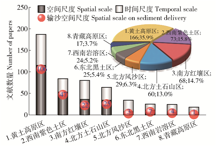
如图 6所示,西北黄土高原区的相关研究最多,其后依次是西南紫色土区、南方红壤区和北方土石山区;而在北方风沙区、东北黑土区、西南岩溶区、青藏高原区的相关研究较少。从文献构成来看,在研究高地黄土高原区和西南紫色土区,以径流输沙空间尺度效应研究为主;而在研究较为薄弱的北方风沙区、西南岩溶区和青藏高原区,大多是针对径流时间尺度效应的研究。
|
1: Loess Plateau region. 2: Southwestern purple soil region. 3: Southern red soil region. 4: Northern rocky mountainous region. 5: Northern windy and sandy region. 6: Northeastern black soil region. 7: Southwestern karst region. 8: Qinghai-Tibet Plateau region. 图 6 不同水土保持分区的分布概况 Fig. 6 Distribution of soil and water conservation region division |
从各水土保持分区的区内研究分布来看,黄土高原区的相关研究主要分布在黄河中游的黄土丘陵沟壑区[14]。西南紫色土区的相关研究则集中在长江上游的川中紫色土丘陵区[15]和三峡水库[2]。南方红壤区相关研究较为分散,主要有长江中下游的赣江[16]、珠江中下游的东江[17]、东南沿海诸河中的晋江[18]和台湾石门水库[19]。北方土石山区则主要有辽河平原区[20]和华北平原区的黄河下游河段[21]、淮河[22]、滦河[23]、海河[24]以及北京密云水库[25]。在北方风沙区,相关研究主要集中在与黄土高原区临近的甘肃[26]和内蒙古[27],而新疆地区研究较少且以塔里木河[28]为主。东北黑土区的相关研究则主要集中在纬度较低的松嫩平原[29]。西南岩溶区相关研究则主要分布在乌江[30]和西江[31]。青藏高原区的相关研究则主要聚焦三江(长江、黄河、澜沧江)源区[6, 32]、岷江上游[33]以及雅鲁藏布江[34]流域。
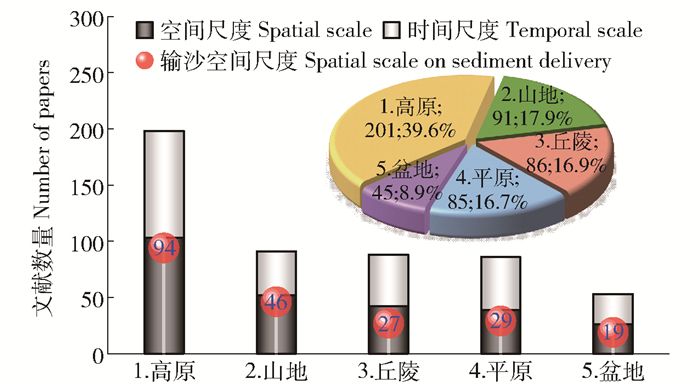
2.5.3 地形区分布如图 7所示,高原是研究开展的主要地形区,尤其是黄土高原,其次是内蒙古高原,而云贵高原和青藏高原研究较少。以山地、丘陵、平原为研究区的研究居中,其中以起伏较大的南方山地、丘陵居多,但由于地形平坦的平原(主要包括华北平原和东北平原)是主要农业区,其所占比例也不少。在地形平缓的盆地区的研究所占比例最少,在5大地形区中仅占不到10%。
|
1: Plateaus. 2: Mountains. 3: Hills. 4: Plains. 5: Basins. 图 7 不同地形区的分布概况 Fig. 7 Distribution of different topographical regions |
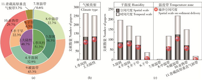
从气候类型(图 8)来看,季风性气候区的相关研究略多;不过由于黄土高原的广泛研究,大陆性气候区的相关研究也不少。从干湿分带来看,现有研究主要集中在降雨较多的湿润和半湿润区;其次是降雨较少的半干旱区;而降水稀少的干旱地区则属于研究洼地。从温度带来看,现有研究主要集中在气温较为适宜的暖温带和亚热带;其次是冬季平均气温低于0 ℃的中温带;气候类型复杂的青藏高原垂直气候带研究较少;由于分布面积较少,在我国寒温带开展的相关研究非常少,而热带地区则尚无相关研究。
|
1: Monsoon. 2: Continentality. 3: Humid. 4: Semihumid. 5: Semiarid. 6: Arid. 7: Frigid temperate zone. 8: Mid temperate zone. 9: Warm temperate zone. 10: Subtropical zone. 11: Vertical climatic zone on the Qinghai-Tibet Plateau. 图 8 不同气候区的分布概况 Fig. 8 Distribution of different climate regions |
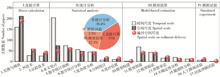
国内径流尺度效应相关研究所采用的研究手段和方法种类繁多,不同研究方法所适用的时空尺度存在差异。如图 9所示,相关研究多采用直接计算和统计分析类方法,其次是模型估算法,利用人工降雨和水槽径流冲刷进行模拟试验的研究很少。
|
1: Measurement and investigation. 2: 3S technology. 3: Tracer technique. 4: Hydrology statistics. 5: Prediction via mathematical statistics. 6: Analysis via mathematical statistics. 7: Analysis via complexity statistics. 8: Spatial statistics. 9: Sediment estimation. 10: Model construction. 11: Model prediction. 12: Model validation. 13: Parameter calibration. 14: Uncertainty analysis. 15: Sensitivity analysis. 16: Rainfall simulation. 17: Scouring simulation. 图 9 不同研究方法的应用概况 Fig. 9 Application overview of different research methods |
直接计算类方法中,多以实测与调查为手段,其中径流小区监测多用于空间尺度效应研究,水文站监测多用于时间尺度效应研究,野外调查多为探索空间尺度效应的辅助手段;3S技术(包括RS、GIS和GPS)多用在流域和区域的大尺度径流输沙相关研究中;同位素示踪技术也是探索径流尺度效应的主要研究方法之一,其中137Cs、210Pb(ex)、7Be等放射性同位素示踪是分析径流输沙空间尺度效应的主要手段,氢氧同位素则是用于监测径流过程和水分来源的常用手段。
统计分析类方法中,水文统计(时间序列分析与预测)是研究径流时间尺度效应的主要方法。其中,时间序列分析法以周期性、季节性、趋势性或突变性分析为主,并有少量时序相关性和频率分析;时间序列预测法以分解预测法[35]为主,其次是灰色预测法和平滑预测法,而涉及时间序列模型法[36]、误差修正模型[37]和弹性系数法[38]的研究极少。此外,数学统计预测(回归分析法、神经网络算法等)和数学统计分析(数理统计、相关分析等)也是重要的统计分析方法。复杂度分析中,景观格局[39]和分形理论[10]多用于空间尺度效应研究,而熵理论[40]、混沌理论[41]和模糊集理论[42]则多用于时间尺度效应研究。空间统计分析(空间插值、叠加分析、缓冲区分析、空间自相关分析等)和泥沙估算(沙量平衡法、泥沙归因诊断等)则多用于探讨径流输沙空间尺度效应。
2.7 应用的数学模型据统计结果,国内径流尺度效应研究涉及到的数学模型有24种(图 10)。从模型结构类型来看,考虑过程时空变化的分布式模型多用于时间尺度效应相关研究,而描述总体平均状态的集总式模型多用于空间尺度效应相关研究。从模型模拟的方式来看,经验模型多用于空间尺度效应相关研究,如USLE[43]、RUSLE[44]、CSLE[45]、HEC[46]和SEDD[47]等模型;而物理模型则多用于时间尺度效应相关研究,如SWAT[48]、SWIM[49]、HMS[46]、HBV[50]、MIKE SHE[51]等模型;介于两者之间的概念模型也多用于时间尺度效应相关研究,如新安江模型[52]、HSPF[53]和陕北模型[54]。
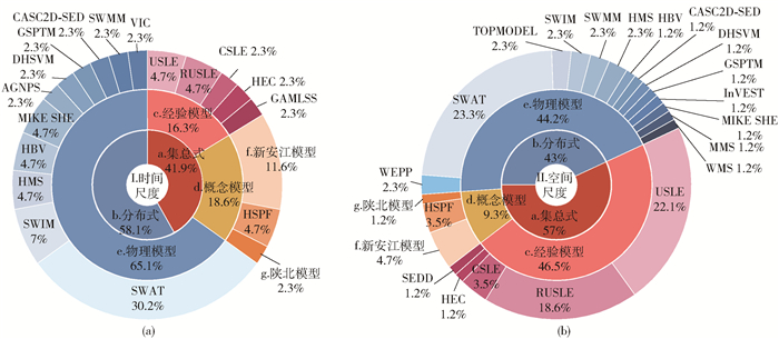
|
Ⅰ: Temporal scale. Ⅱ: Spatial scale. a: Lumped model. b: Distributed model. c: Empirical model. d: Conceptual model. e: Physical model. f: Xin′anjiang model. g: Shaanbei model. 图 10 我国径流时间尺度和空间尺度相关研究数学模型应用概况 Fig. 10 Overview of the application of different numerical models for temporal scale and spatial scale |
20世纪80年代末以来,国内众多学者进行了大量关于地表水文、径流过程和输沙过程的时空尺度效应研究,研究区分布广泛,研究方法和手段多种多样,不同研究区、不同研究方法、不同尺度下得到的结果之间的可比性和推广性问题尚需探讨。径流小区和水文站观测资料时间序列多为连续的高时间分辨率的次降雨或日尺度数据,而不同集水区的汇水面积大小具有较强的随机性,通常表现为不连续的低空间分辨率;由此导致径流时间尺度效应的研究较多,而空间尺度效应研究则相对薄弱。而且,关于径流空间尺度效应的研究中,近八成最终落脚于其输沙空间尺度效应或泥沙输移比的研究上,而纯粹或真正关注径流的空间尺度效应研究较少,其研究深度和水平有待进一步提高。径流汇水面积的随机性和不连续性还会引发模拟尺度与观测尺度的不一致,给径流数据的空间尺度转换造成了很大困难。总体而言,尽管径流尺度问题的研究在我国已有三十余年的历史,但迄今尚处于发展和探讨阶段,其中关于尺度转换,尤其是降尺度研究,则更是目前的难点和热点问题。
可预见,基于分形理论、混沌理论、小波分析、人工神经网络算法和分布式水文模型等多种新技术攻克水文尺度转换难题,将成为未来径流尺度效应研究的主要方向之一。其中,能与观测数据时空尺度相匹配和能与气候模型时空尺度相匹配的变尺度水文模型是未来的开发趋势。此外,准确把握不同地理分区不同尺度下的主导水文过程,可提升水文模型在不同地区的多尺度预测精度。而加强水文连通性尺度效应研究和跨学科的综合研究,可能为进一步解决径流尺度问题开拓新思路。在全球气候极端化的背景下,有关极端暴雨条件下洪水过程的时空尺度问题将成为未来研究的重点,而与现代技术如GIS和遥感动态监测技术、多尺度洪水预报技术等的紧密结合将成为新的研究趋势。
| [1] |
刘纪根, 蔡强国, 刘前进, 等. 流域侵蚀产沙过程随尺度变化规律研究[J]. 泥沙研究, 2005, 17(4): 7. LIU Jigen, CAI Qiangguo, LIU Qianjin, et al. Study on the regularity of sediment yield processes in catchments under different scales[J]. Journal of Sediment Research, 2005, 17(4): 7. DOI:10.3321/j.issn:0468-155X.2005.04.002 |
| [2] |
倪九派. 三峡库区水土流失空间尺度效应及其尺度转换研究[D]. 重庆: 西南大学, 2005: 1. NI Jiupai. Effect of spatial scale and scaling on soil and water loss in Three Gorges Reservoir Area[D]. Chongqing: Southwest University, 2005. |
| [3] |
刘春蓁. 关于水文气象学研究中的时空尺度问题[J]. 气象科技, 1989, 9(2): 54. LIU Chunzhen. Spatio-temporal scale in the study of Hydrometeorology[J]. Meteorological Science and Technology, 1989, 9(2): 54. DOI:10.19517/j.1671-6345.1989.02.009 |
| [4] |
张光科, 刘东, 方铎. 山区流域坡面径流侵蚀和泥沙输移分析[J]. 四川联合大学学报(工程科学版), 1997, 1(6): 12. ZHANG Guangke, LIU Dong, FANG Duo. A study of erosion and sediment transport on the hillslopes surface in mountain watershed[J]. Journal of Sichuan University (Engineering Science Edition), 1997, 1(6): 12. |
| [5] |
陈国祥, 汤立群. 流域尺度与治理对产流模式的影响分析研究[J]. 土壤侵蚀与水土保持学报, 1996, 2(1): 22. CHEN Guoxiang, TANG Liqun. Study on the runoff-generating model influenced by controlling and scale[J]. Journal of Soil Erosion and Soil and Water Conservation, 1996, 2(1): 22. |
| [6] |
尤卫红, 何大明. 澜沧江月径流量变化的相关性和多时间尺度特征[J]. 云南大学学报: 自然科学版, 2005, 27(4): 314. YOU Weihong, HE Daming. Correlation and multi-timescale characteristics of the monthly variations for Lancang River flow in the region of Yunnan[J]. Journal of Yunnan University (Natural Sciences Edition), 2005, 27(4): 314. DOI:10.3321/j.issn:0258-7971.2005.04.009 |
| [7] |
赵辉, 郭索彦, 解明曙, 等. 不同尺度流域日径流分形特征[J]. 应用生态学报, 2011, 22(1): 159. ZHAO Hui, GUO Suoyan, XIE Mingshu, et al. Fractal characteristics of daily discharge in different scales watersheds[J]. Chinese Journal of Applied Ecology, 2011, 22(1): 159. DOI:10.13287/j.1001-9332.2011.0002 |
| [8] |
王平, 李浩, 陈强, 等. 典型黑土区不同尺度观测场地融雪径流[J]. 水土保持通报, 2014, 34(5): 244. WANG Ping, LI Hao, CHEN Qiang, et al. Different scale observation sites of snow melt runoff in typical black soil area[J]. Bulletin of Soil and Water Conservation, 2014, 34(5): 244. DOI:10.13961/j.cnki.stbctb.2014.05.051 |
| [9] |
崔玉环, 叶柏生, 王杰, 等. 乌鲁木齐河源1号冰川水文断面不同时间尺度径流估算[J]. 干旱区资源与环境, 2013, 27(7): 119. CUI Yuhuan, YE Baisheng, WANG Jie, et al. The runoff simulations for the Glacier No.1 hydrologic section at the headwaters of the Urumqi river on the different timescales[J]. Journal of Arid Land Resources and Environment, 2013, 27(7): 119. |
| [10] |
刘时城. 延河流域不同尺度水文连通性研究[D]. 陕西杨凌: 西北农林科技大学, 2017: 1. LIU Shicheng. Research on hydrological connectivity at different scales in Yanhe river catchment[D]. Yangling, Shaanxi: Northwest A & F University, 2017: 1. |
| [11] |
曹文洪, 张启舜, 姜乃森. 黄土地区一次暴雨产沙数学模型的研究[J]. 泥沙研究, 1994, 6(1): 1. CAO Wenhong, ZHANG Qishun, JIANG Naiseng. The study on mathematical model for sediment yields caused by one storm in loess zone[J]. Journal of Sediment Research, 1994, 6(1): 1. DOI:10.16239/j.cnki.0468-155x.1994.01.001 |
| [12] |
闫云霞, 许炯心, Marwan HASSON, 等. 长江流域侵蚀产沙尺度效应的区域分异[J]. 山地学报, 2011, 29(2): 141. YAN Yunxia, XU Jiongxin, Marwan HASSON, et al. Spatial variation of scale effects of sediment yield in the Yangtze River basin[J]. Journal of Mountain Science, 2011, 29(2): 141. DOI:10.3969/j.issn.1008-2786.2011.02.002 |
| [13] |
LI Jiake, MU Cong, DENG Chenning, et al. Hydrologic-environmental effects of sponge city under different spatial scales[J]. Journal of Water Reuse and Desalination, 2020, 10(1): 45. DOI:10.2166/wrd.2019.046 |
| [14] |
方海燕. 黄土丘陵沟壑区产流产沙尺度效应及泥沙输移动态研究[D]. 北京: 中国科学院地理科学与资源研究所, 2008: 1. FANG Haiyan. Study on the scale effect of runoff and sediment productions and sediment transport dynamics in hilly loess region on the Loess Plateau[D]. Beijing: Institute of Geographic Sciences and Natural Resources Research, CAS, 2008: 1. |
| [15] |
张培. 紫色土丘陵区小流域径流和泥沙过程对降雨的多尺度响应规律研究[D]. 重庆: 西南大学, 2014: 1. ZHANG Pei. Purple soil hilly region of small watershed runoff and sediment processes on multi-scale study of the response of precipitation[D]. Chongqing: Southwest University, 2014: 1. |
| [16] |
万智巍, 贾玉连, 洪祎君, 等. 基于完备集合经验模态分解的赣江径流多尺度变化特征[J]. 水力发电, 2018, 44(8): 18. WAN Zhiwei, JIA Yulian, HONG Yijun, et al. Multi-scale variation characteristics of Ganjiang River's runoff based on CEEMD[J]. Water Power, 2018, 44(8): 18. DOI:10.3969/j.issn.0559-9342.2018.08.006 |
| [17] |
王兆礼, 陈晓宏, 杨涛. 东江流域博罗站天然年径流量序列多时间尺度分析[J]. 中国农村水利水电, 2010, 52(2): 21. WANG Zhaoli, CHEN Xiaohong, YANG Tao. Multiple time scale analysis of natural annual runoff series at the Boluo Station in the Dongjiang River Basin[J]. China Rural Water and Hydropower, 2010, 52(2): 21. |
| [18] |
林炳青. 流域景观格局变化对不同时间尺度径流影响的SWAT模拟分析[D]. 福州: 福建师范大学, 2014: 1. LIN Bingqing. Simulations and analysis of landscape pattern change impacts on catchment runoff at different temporal scales based on SWAT[D]. Fuzhou: Fujian Normal University, 2014: 1. |
| [19] |
CHEN Yichin, WU Yinghsin, SHEN Chewei, et al. Dynamic modeling of sediment budget in Shihmen reservoir watershed in Taiwan[J]. Water, 2018, 10(12): 1808. DOI:10.3390/w10121808 |
| [20] |
毛玉娜, 叶爱中, 徐静. 辽河流域径流过程模拟的空间尺度效应分析[J]. 水文, 2014, 34(2): 19. MAO Yuna, YE Aizhong, XU Jing. Spatial scale analysis of runoff simulation for Liaohe River Basin[J]. Journal of China Hydrology, 2014, 34(2): 19. |
| [21] |
王乐平, 孙雪岚. 黄河下游径流输沙多时间尺度特征及其耦合分析[J]. 水利水电技术, 2016, 47(2): 58. WANG Leping, SUN Xuelan. Multi-timescale characteristics of runoff and sediment discharge along Lower Yellow River and their coupling analysis[J]. Water Resources and Hydropower Engineering, 2016, 47(2): 58. |
| [22] |
汪跃军. 淮河干流蚌埠水文站年径流系列多时间尺度分析[J]. 水利技术监督, 2007, 15(1): 37. WANG Yuejun. Multiple time dimensional analysis for annual run-off corollary of Bengbu hydrographic station of mainstream of Huaihe River[J]. Technical Supervision in Water Resources, 2007, 15(1): 37. |
| [23] |
FENG Ping, LI Jianzhu. Scale effects on runoff generation in meso-scale and large-scale sub-basins in the Luanhe River Basin[J]. Hydrology and Earth System Sciences Discussions, 2008, 5(3): 1511. |
| [24] |
刘佳凯, 张振明, 鄢郭馨, 等. 潮白河流域径流对降雨的多尺度响应[J]. 中国水土保持科学, 2016, 14(4): 50. LIU Jiakai, ZHANG Zhenming, YAN Guoxin, et al. Multi-scale analysis on precipitation-runoff relationship in Chaobaihe Basin[J]. Science of Soil and Water Conservation, 2016, 14(4): 50. |
| [25] |
秦永胜, 余新晓, 陈丽华, 等. 北京密云水库流域水源保护林区径流空间尺度效应的研究[J]. 生态学报, 2001, 21(6): 913. QIN Yongsheng, YU Xinxiao, CHEN Lihua, et al. Spatial scale effects of runoff on the water resource conservation forest watershed within the Miyun reservoir basin[J]. Acta Ecologica Sinica, 2001, 21(6): 913. |
| [26] |
郭静, 粟晓玲. 石羊河流域出山口径流序列的多时间尺度特征[J]. 西北农林科技大学学报(自然科学版), 2013, 41(6): 213. GUO Jing, SU Xiaoling. Multiple time scale characteristics of mountainous runoff series in Shiyang river basin[J]. Journal of Northwest A & F University (Natural Science Edition), 2013, 41(6): 213. |
| [27] |
薛浩, 于瑞宏, 张艳霞, 等. 内蒙古典型草原区流域在不同时间尺度下的径流深动态变化: 以锡林河流域为例[J]. 中国水土保持科学, 2019, 17(2): 27. XUE Hao, YU Ruihong, ZHANG Yanxia, et al. Temporal variation of runoff depth in the drainage basin of typical grassland area in Inner Mongolia: A case study of Xilin River Basin[J]. Science of Soil and Water Conservation, 2019, 17(2): 27. |
| [28] |
LYU Jiqiang, SHEN Bing, LI Huaien. Characterizing hydrologic response at multiple time scales for Tarim River basin headstreams[J]. Journal American Water Works Association, 2015, 107(5). |
| [29] |
李鸿雁, 姜珊, 李鹏. 嫩江流域径流的可预报性及其时间尺度分析[J]. 水文, 2009, 29(6): 20. LI Hongyan, JIANG Shan, LI Peng. Analysis of predictability and time scales for the Nenjiang River runoff[J]. Journal of China Hydrology, 2009, 29(6): 20. |
| [30] |
WANG Yao, HOU Lisheng, CAI Yunlong. Scale effects of eroded sediment transport in Wujiang River Basin, Guizhou province, China[J]. Journal of Groundwater Science and Engineering, 2017, 5(2): 182. |
| [31] |
朱靖轩, 刘雯, 李振炜, 等. 喀斯特流域径流对植被和气候变化的多尺度响应[J]. 生态学报, 2020, 40(10): 3396. ZHU Jingxuan, LIU Wen, LI Zhenwei, et al. Multi-scale response of runoff to vegetation and climate change in karst watersheds[J]. Acta Ecologica Sinica, 2020, 40(10): 3396. |
| [32] |
JIANG Chong, ZHANG Linbo, TANG Zhipeng. Multi-temporal scale changes of streamflow and sediment discharge in the headwaters of Yellow River and Yangtze River on the Tibetan Plateau, China[J]. Ecological Engineering, 2017, 102: 240. |
| [33] |
邵骏, 袁鹏, 李秀峰. 岷江上游年径流变化的多时间尺度分析[J]. 东北水利水电, 2007, 25(6): 52. SHAO Jun, YUAN Peng, LI Xiufeng. Multi-time dimension analysis of annual runoff variation in upstream of Minjiang river[J]. Water Resources & Hydropower of Northeast China, 2007, 25(6): 52. |
| [34] |
邵骏, 袁鹏, 张文江, 等. 基于HHT变换的雅鲁藏布江径流多时间尺度分析[J]. 水电能源科学, 2009, 27(5): 8. SHAO Jun, YUAN Peng, ZHANG Wenjiang, et al. Multi-temporal scales analysis of runoff series in Yarlung Zangbo River Based on Hilbert-Huang Transform[J]. Water Resources and Power, 2009, 27(5): 8. |
| [35] |
谢国权, 丁志宏. 渭河年径流量多时间尺度分析的EMD方法[J]. 人民黄河, 2008, 30(8): 36. XIE Guoquan, DING Zhihong. EMD method for multi-time-scale analysis of annual runoff of Weihe River[J]. Yellow River, 2008, 30(8): 36. |
| [36] |
刘艳, 杨耘, 聂磊, 等. 玛纳斯河出山口径流EEMD-ARIMA预测[J]. 水土保持研究, 2017, 24(6): 273. LIU Yan, YANG Yun, NIE Lei, et al. The EEMD-ARIMA prediction of runoff at mountain pass of Manas River[J]. Research of Soil and Water Conservation, 2017, 24(6): 273. |
| [37] |
ZHANG Jinping, ZHAO Yong, LIN Xiaomin. Uncertainty analysis and prediction of river runoff with multi-time scales[J]. Water Science and Technology: Water Supply, 2017, 17(3): 897. |
| [38] |
龚珏, 杜洪勋, 郑江坤, 等. 川北典型小流域产流对降雨的多时间尺度响应规律[J]. 长江流域资源与环境, 2020, 29(6): 1445. GONG Jue, DU Hongxun, ZHENG Jiangkun, et al. Response of runoff to rainfall in multi-time scale of typical small watershed in northern Sichuan province[J]. Resources and Environment in the Yangtze Basin, 2020, 29(6): 1445. |
| [39] |
杨晓楠. 黄土高原多尺度景观格局对径流及输沙过程的影响[D]. 陕西杨凌: 西北农林科技大学, 2019: 1. YANG Xiaonan. Effects of landscape pattern on runoff and sediment in the Loess Plateau: A multi-scale study[D]. Yangling, Shaanxi: Northwest A & F University, 2019: 1. |
| [40] |
ZHANG Jinping, XIAO Honglin, ZHANG Xin, et al. Impact of reservoir operation on runoff and sediment load at multi-time scales based on entropy theory[J]. Journal of Hydrology, 2019, 569: 809. |
| [41] |
LI Xinjie, GAO Guoming, HU Tiesong, et al. Multiple time scales analysis of runoff series based on the chaos theory[J]. Desalination and Water Treatment, 2014, 52(13): 2741. |
| [42] |
WANG Caiyuan, YANG Zhongshan, ZANG Ming, et al. Evolution characteristics and variability analyzation of rainfall and runoff based on time scale[J]. IOP Conference Series: Earth and Environmental Science, 2019, 358: 22010. |
| [43] |
吴松柏. 坡面水力侵蚀过程中坡度与尺度效应研究[D]. 武汉: 武汉大学, 2017: 1. WU Songbai. Study on the slope and scale effects during rainfall-runoff and soil erosion processes[D]. Wuhan: Wuhan University, 2017: 1. |
| [44] |
王志杰, 简金世, 焦菊英, 等. 基于RUSLE的松花江流域不同侵蚀类型区泥沙输移比估算[J]. 水土保持研究, 2013, 20(5): 50. WANG Zhijie, JIAN Jinshi, JIAO Juying, et al. Estimation of sediment delivery ratio in different soil erosion regions in the Songhua River Basin based on RUSLE[J]. Research of Soil and Water Conservation, 2013, 20(5): 50. |
| [45] |
程琳. 基于GIS和经验模型的中尺度流域土壤侵蚀时空动态分析: 以孤山川流域为例[D]. 陕西杨凌: 西北农林科技大学, 2010: 1. CHENG Lin. Spatio-temporal dynamic analysis of soil erosion in meso-scale watershed based on GIS: A case study of Gushanchuan watershed[D]. Yangling, Shaanxi: Northwest A & F University, 2010: 1. |
| [46] |
林峰, 陈桂芳. HEC-HMS分布式水文模型的时间尺度效应研究[J]. 吉林师范大学学报(自然科学版), 2009, 30(3): 132. LIN Feng, CHEN Guifang. Effects of time step of HEC-HMS on hydrological processes modeling[J]. Jilin Normal University Journal (Natural Science Edition), 2009, 30(3): 132. |
| [47] |
夏圣伟. 基于分布式SEDD模型的赣江河道输沙量对流域森林植被恢复的响应研究[D]. 南昌: 南昌工程学院, 2018: 1. XIA Shengwei. The response of sediment discharge on reforestration in Ganjiang River Basin based on distributed SEDD model[D]. Nanchang: Nanchang Institute of Technology, 2018: 1. |
| [48] |
张东海. 基于SWAT模型水文过程的尺度效应分析[D]. 西安: 陕西师范大学, 2013: 1. ZHANG Donghai. Scale effect analysis of hydrological processes based on SWAT model[D]. Xi'an: Shaanxi Normal University, 2013: 1. |
| [49] |
高超, 金高洁. SWIM水文模型的DEM尺度效应[J]. 地理研究, 2012, 31(3): 399. GAO Chao, JIN Gaojie. Effects of DEM resolution on results of the SWIM hydrological model in the Changtaiguan basin[J]. Geographical Research, 2012, 31(3): 399. |
| [50] |
GAO Chao, YAO Mengting, WANG Yanjun, et al. Hydrological model comparison and assessment: Criteria from catchment scales and temporal resolution[J]. Hydrological Sciences Journal, 2016, 61(10): 1941. |
| [51] |
李大洋, 梁忠民, 周艳. 基于MIKE SHE的洪水模拟与尺度效应分析[J]. 水力发电, 2019, 45(5): 28. LI Dayang, LIANG Zhongming, ZHOU Yan. Flood simulation and scaling effect analysis based on MIKE SHE[J]. Water Power, 2019, 45(5): 28. |
| [52] |
盛晟, 陈华, 林康聆, 等. 不同时空尺度下新安江模型参数敏感性分析[J]. 水资源研究, 2018, 7(6): 541. SHENG Sheng, CHEN Hua, LIN Kangling, et al. Parameters sensitivity analysis of the Xin'anjiang Model under different temporal and spatial scales[J]. Journal of Water Resources Research, 2018, 7(6): 541. |
| [53] |
CHEN Ying, XU Chongyu, CHEN Xingwei, et al. Uncertainty in simulation of land-use change impacts on catchment runoff with multi-time scales based on the comparison of the HSPF and SWAT models[J]. Journal of Hydrology, 2019, 573: 486. |
| [54] |
REN Liliang, ZHANG Wei, LI Chunhong, et al. Comparison of runoff parameterization schemes with spatial heterogeneity across different temporal scales in semihumid and semiarid regions[J]. Journal of Hydrologic Engineering, 2008, 13(5): 400. |
 2023, Vol. 21


