2. 西安理工大学, 旱区生态水文与灾害防治国家林业局重点实验室, 710048, 西安
-
项目名称
- 国家自然科学基金"基于侵蚀能量过程的长江经济带集合式流域水土流失预报模型"(U2040208), "全沙坡面流挟沙力机理与侵蚀过程高分辨数值模拟研究"(52009104), "沉水植被对河道中泥沙沉积和输移的影响机理研究"(52109100);陕西省水利科技计划项目"窟野河流域水沙关系变化趋势与水土保持治理布局研究"(2022slkj-04)
-
第一作者简介
- 陈琦涛(1998-), 男, 硕士研究生。主要研究方向: 流域泥沙与生态水利。E-mail: 695455437@qq.com
-
通信作者简介
- 王添(1989-), 男, 博士, 讲师。主要研究方向: 流域泥沙与生态水利。E-mail: t.wang@xaut.edu.cn
-
文章历史
-
收稿日期:2021-11-22
修回日期:2023-02-23
2. 西安理工大学, 旱区生态水文与灾害防治国家林业局重点实验室, 710048, 西安
2. Key Laboratory of National Forestry Administration on Ecological Hydrology and Disaster Prevention in Arid Regions, Xi'an University of Technology, 710048, Xi'an, China
土壤侵蚀是全球性的重大环境问题之一,流域泥沙来源作为土壤侵蚀研究的核心内容之一,受到广泛的关注和研究。自20世纪70年代起,指纹识别法逐渐成为研究流域土壤侵蚀与泥沙输移的新方法,现已是流域泥沙来源研究的热点[1-2]。指纹识别法通过采集潜泥沙源地土壤样品以及泥沙汇点沉积样品,分析源汇土壤的属性,筛选出能够识别不同泥沙源地的土壤物化指标作为潜在指纹因子,根据混合模型,定量分析泥沙各来源的相对贡献[3]。最初指纹法的应用基于对单一诊断指纹(参数)的定性解释,这些指纹因子主要包括泥沙的基本地球物理性质,如粒径、颜色、矿物形态和磁性等;但单一指纹技术有许多缺点,且具有明显的空间局限性,因此复合指纹技术应运而生,如复合核素示踪法[4-5],土壤中有机组分[3]、地球化学元素复合指纹[6]等,还有近年来兴起的分子标志物[7]。指纹识别技术能够为流域水土流失现状调查、侵蚀产沙平衡计算、水土保持效益评价、流域水土流失及面源污染治理提供理论指导[8]。
为宏观掌握指纹识别泥沙来源的发展动态,为水土保持工作开展和土壤侵蚀研究提供参考方向。笔者首先基于1991—2021年累计30年间全球与指纹技识别泥沙来源相关的核心期刊论文进行统计分析,然后统计描述指纹识别泥沙来源研究信息分布现状,进一步分析指纹识别泥沙来源的研究进展与前沿热点。研究结果对优化水土保持措施配置提供重要的科学依据有重要意义。
1 数据与方法为统计分析指纹识别泥沙来源领域的研究内容和主要方向,将1991—2021年收录于Web of Science核心合集的article和review,以及中国知网(CNKI) 数据库的科学引文索引、工程索引、北大核心、中国社会科学索引来源文献作为数据源,分别以“指纹”或“泥沙来源”和“fingerprint”or“sediment source”为关键词进行筛选,在中国知网(CNKI)中得到68篇文献,Web of Science检索显示1 358篇。最后检索时间为2021年11月12日。
对指纹识别流域泥沙来源文献进行统计描述,得到研究信息的时间、空间、来源等分布情况,概述指纹识别泥沙来源的研究现状;通过计量分析软件CiteSpace和VOSviewer对文献进行计量分析,归纳指纹识别泥沙来源的发展脉络及近30年间的研究前沿热点。
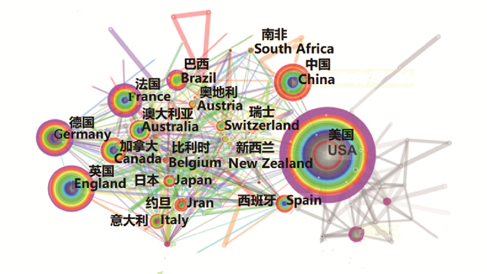
图中色度条由灰到红代表时间线1991—2021年,节点大小代表文章数量,颜色代表文章的发表年限,厚度代表文章的发表数量,连线代表合作关系,连线的粗细代表合作的紧密程度,颜色代表合作的时间,节点内的红圈代表突变,表示在这个时间段内的发文数量发生突变,括号内数字代表中心性,具有粉紫色外圈代表中心性>0.1。
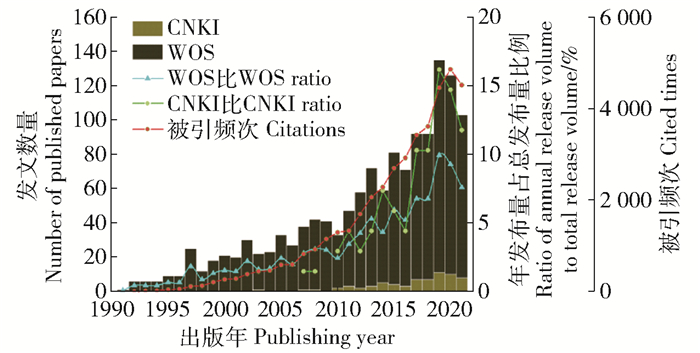
2 研究信息统计 2.1 时间分布近30年文献数量的分布如图 1。1990—1996年处于缓式发展,论文数量仅占总量的2.7%,1997年以后增长速度明显加快,到2019年增长率和论文年发布数达到峰值,分别为46%和130篇,被引频次在2020年达到峰值4 859次,近3年的文章数占总数的比例分别为42.6%和26.8%,说明近些年国内外对该领域有极大的热情和关注度,持续增长的势头依然强劲。特别的,国内文章数量很少,仅仅占外文的7%,说明国内学者更倾向于将文章发于外文期刊。
|
CNKI:China National Knowledge Infrastructure. WOS:Web of Science。 图 1 1990—2021年指纹识别泥沙来源相关文献数量分布总览 Fig. 1 Distribution overview of literature number related to fingerprint identifying sediment source from 1990 to 2021 |
中国、美国和英国是研究指纹识别泥沙来源的主要国家。如图 2所示,美国中心性最大,显示其在研究关系网络中的巨大的影响力,2015年左右的时间段是各国合作最频繁的时间段。中国自2018年起发文量大幅增长,在2020年年发文量达到第1名,近几年被引频率也逐渐攀升,但是中介中心性很低,与其他国家的合作较少,说明研究成果的国际影响力不够高,应该加强在该领域的科研创造性。
|
图 2 文献主要产出国家及其之间的联系 Fig. 2 Main output countries of the literature and the connections between them |
根据Web of Science统计数据,在指纹识别泥沙来源文献发布量前15的机构单位中国机构在前15个中占5个。图 3给出主要机构间的合作关系网:分为4个重点区域,1区为中国科学院、美国地质调查局为主要的合作群落。中国科学院发文数量和中介中心性都位居第一。1区域合作机构间地理位置跨度大,机构间联系广泛。近5年活跃度高,所发表的文章影响力中等。2区为英国的洛桑研究所、埃克塞特大学和美国地质调查局为首组成的研究群。该区域机构数低于1区,但是机构间的合作程度高,所发表的文章影响力大,是该领域的领先机构群。3区为西班牙研究委员会为核心的小研究群落,该机构与其他主要机构合作极少,平均被引频次也偏低,论文影响力较弱。4区为以巴黎萨克雷大学为核心的中小研究群落,整个合作群落较为分散,区域联动性较差。

|
①②③④表示4个重点区域编号. ①②③④ indicates the 4 key area numbering 图 3 文献主要产出机构/单位及其合作联系 Fig. 3 Major institutions of literature output and their cooperation links |
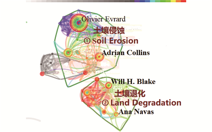
作者合作关系如图 4所示,筛选出3个聚类组。Adrian Collins和Olivier Evrard等组成的集群主要是研究土壤侵蚀方面的问题。他们对指纹识别泥沙来源的现有方法步骤进行改进,并且比较各种指纹因子;且群落内的作者近期的文章都开始聚焦于不确定性的研究以及方法的规范[9-10]。此群整体的研究结果质量和研究热情最高,但是集群作者间的合作强度不高。Will H. Blake和Ana Navas的集群主要在土壤退化这个大框架下进行研究,研究主要集中于对应用校正因子解释广泛的地球化学指纹的粒度和有机质含量差异的一些潜在问题进行尝试性的解决[11]。
|
Cluster 0 by Adrian Collins, Olivier Evrard, et al. theme of soil erosion, cluster 1 by Will H. Blake, Ana Navas and others focuses on and degradation 图 4 作者合作及其研究聚类 Fig. 4 Author collaboration and research cluster |
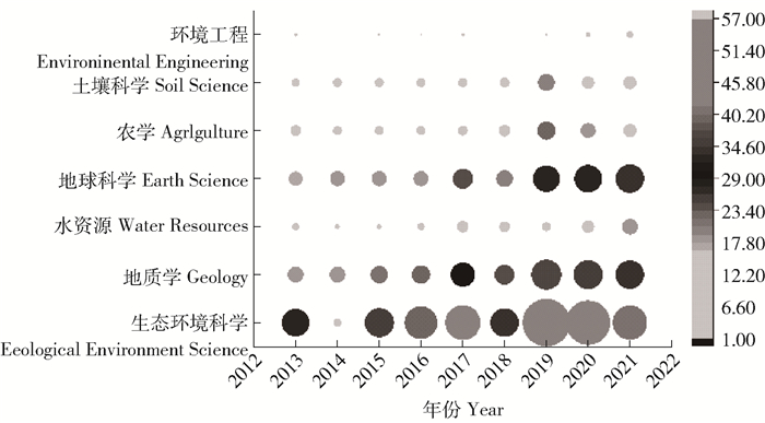
根据Web of Science分类学科领域对指纹识别泥沙来源的研究主题进行统计,结果如图 5所示。指纹研究泥沙来源的主要学科领域为环境科学与生态学,地质学,由中心性和数量比例也可以看出,指纹识别沉积物主要集中在环境、生态、地质这3个领域。环境工程领域、土壤科学领域、水资源领域虽然发文量不高,近年来发文数量增势很高,可以判断出它们将是未来指纹识别沉积物来源的主要领域。
|
右侧色度指相应领域在当年的文献数量占累计文献数量的比例,%。 The chromaticity on the right refers to the percentage of the number of in the corresponding field in the current year to the cumulative number of papers. 图 5 研究领域在2008—2020年间的衍变矩阵分析top 7 Fig. 5 Top 7 of the evolution matrix analysis of the research field from 2008 to 2020 |
对Web of Science论文进行研究关键词聚类分析,如图 6所示,一共生成10个不同的聚类,标签字体大小代表频次,聚类序号越小所包含的关键词越多,内容越重要。将其进一步分为3个大类,第1大类是指纹因子类(6、8、9、10),指纹因子类的聚类范围大,研究的主要内容是寻找最适合研究对象的指纹因子和最有效的指纹因子组合;第2大类为分析方法类(1、2、3、4、7),分析方法大聚类主要内容是获得样品特性的方法、不确定性的分析、模型的改进等。第3大类为研究区域类(5)。研究区域大聚类中农业集水区所包含的关键词最多,表明大部分关于指纹识别泥沙来源的研究都是集中在农业区附近的流域和河流。
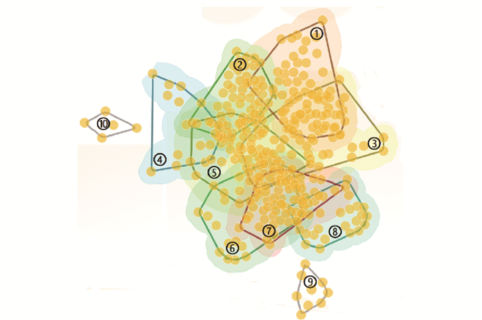
|
1:沉积物指纹、2:混合模型、3:源解析、4:不确定性、5:农业集水区、6:放射性核素、7:构造演化、8:示踪因子、9:多环芳香烃、10:含碳量。 1:Sediment fingerprint.2:Mixing model.3:Source appointment.4:Uncertainty.5:Agricultural catchment.6:Fallout radionuclides. 7:Tectonic.8:Trace element.9:Pahs.10:Carbon. 图 6 关键词及术语共现聚类图谱 Fig. 6 Keywords and terms co-occurrence clustering map |
指纹识别技术直接基于泥沙颗粒本身的属性,根据侵蚀泥沙的物理、化学及生物等特性实现源的判别。如表 1所示,现有文献中采用的指纹识别因子,在物理特性方面,Pulley等[12]使用土样颜色,De Boer等[13]使用土样颗粒的形态特征。王晓[14]基于粒度。在化学特性上,Athanasios[15]利用13C、15N及C/N,Collins等[16]利用地化元素浓度构,Oldfield等[17]基于不同的磁性参数。Wallbrink等[18]利用137Cs和210Pbex,TURNER等[19]利用REE,其他的如Cooper等[20]利用生物标志物,Poulenard等[21]使用红外光谱。
| 表 1 泥沙来源定量计算模型及指纹因子 Tab. 1 Quantitative calculation model of sediment source and fingerprint factor |
国内外学者对定量模型及其结果精度的校准进行深入探索,Walling[22]基于指纹识别方法的概念模型,在研究中首先提出基于多参数的多元混合模型。Collins等[16]在此基础上结合有机质含量修正系数进行校准,Motha等[23]和Hughes等[24]基于蒙特卡洛模拟法构建模型,Collins等[25]在研究中提出修正Collins混合模型有效提高混合模型的计算精度,DEVEREUX等构建Landwehr模型,通过最小化平均绝对差来对不同物源的产沙贡献进行定量求解[26]。目前运用最为广泛的是传统Walling模型。测试和比较多种模型的精确度成为当前研究的固定程序。
3.3 研究前沿和热点表 2表示主要关键词在某时间段的突变。分成3个阶段进行分析。
| 表 2 前10个主要关键词 Tab. 2 Top 10 main keywords |
第1阶段(1991—2005年),这时指纹分析法主要用于河口、湖泊等的污染物和沉积物来源的分析,主要分析水、污染物、沉积物的化学组成[29],生物粪便中的化学元素含量也被做指纹因子来判断生物对环境的生态作用,这为后来生物标记物识别泥沙来源提供了思路。
第2阶段(2005—2018年),研究者们开始根据研究区域环境特征选择各种指纹因子,如使用指纹识别法分析城市地下污水扩散源[30],通过指纹识别法评估土壤管理与建设对农业生产的影响[31]。学者们开始对具有复杂指纹因子和更多不确定性的区块进行挑战[32]。另一边也有学者开始从成本、时间和劳动力需求方面寻找新的指纹识别方法,Martinez-Carreras等[33]提出基于光谱反射率的指纹识别方法具有相当大的潜力,使用磁化率进行泥沙来源的追踪也被认为是简单且廉价的方法[34]。
第3阶段(2018—2021年)对整个方法过程中不确定性的研究成为热门,主要集中于发现各种不确定性和量化各种不确定性。如源地识别的不确定性[35],样品采集的不确定性[36],指纹性质的潜在变化[37]。
如何在土壤源层划分中考虑成土过程以及需要不同的采样策略来模拟特定的泥沙组成[37]的也是现在的一个重要问题。研究者开始详细研究沉积物源组的客观分类,如此可以在统计上改善沉积物源之间的区分,并减少不确定性。对泥沙来源的考虑范围开始扩大。研究开始着重考虑沉积物来源的空间和时间变异性,如源区距离、颗粒的大小和有机质含量、泥沙输移时间等。
结合表 2以及相关文献总结出当前的研究前沿为以下3方面:
1) 指纹因子再提升。指纹因子的选择和组合直接决定结果的值以及作用的范围。当前研究调查指纹因子在不同地貌环境中的适用性,给指纹因子及组合的筛选增加除了保守性更多限制条件。指纹因子的时空变异性及其影响、指纹因子基于知识的预选、新型示踪剂、生物标志物的浓度依赖性、等都是当前研究热点。
2) 多样区域和更大流域尺度。近30年的研究大多集中在小流域尺度下的地下地表土壤以及农业集水区的泥沙来源。近几年的研究开始逐渐向更大更多样的方向靠拢。评估大型/中型集水区在更多的源地类型、侵蚀类型,在更加复杂和高度分散的土地利用配置,以及高度动态的土地利用转换率下的泥沙来源。为指纹识别泥沙来源的普遍性研究提供基础。
3) 向实用工具转变。沉积物源指纹识别在全球范围内的流行继续呈上升趋势,但随着这种增长,出现了围绕缺乏标准化和程序多样性的问题。因此,对指纹识别泥沙来源的关键程序细节进行标准化,以确保更高的协调性、可比性和高标准,评估该方法在支持改善水土可持续性管理方面的战略效用。将指纹识别泥沙来源与年份测定相结合、与空间信息的结合以增强源区分和建模、与分析过程集成用于数据处理的软件工具的模型和开发。这些研究工作代表着指纹识别泥沙来源正在逐渐成为一个实用科学的监测和管理工具来为水土保持实践提供信息。
4 结论1) 指纹识别法研究泥沙来源在1997年起步入正轨,在2013—2019进入研究高热期,在2019年达到顶峰,2019年后文献数量增势均下降。2)欧洲、北美洲和亚太地区是指纹识别泥沙来源的主要研究区域,以中国、美国、英国、德国为代表。英法德是指纹识别泥沙来源的先驱国家,美国现在是该领域的中心国家,中国虽起步晚,但近5年有巨大进步。3)国际机构主要以中国科学院、英国的洛桑研究所、西班牙研究委员会、巴黎萨克雷大学为中心为4个中心,而美国机构(美国地质调查局)与所有中心机构都有广泛而密切的合作。英国的埃克塞特大学发文质量最高。除了法国机构外,世界上其他机构近3年发文量都处于下降趋势。来自欧洲和美国的研究学者最为活跃,从整体上来看,全球的研究者间的合作程度普遍较低。4)指纹识别沉积物主要集中在环境、生态、地质这3个领域,且正在逐渐的向环境工程领域、土壤科学领域、水资源领域倾斜。研究的主要内容为指纹因子的选取,评价和判断泥沙贡献率的分析方法,重心已经在向不确定性的分析和模型的提升靠拢。5)当前研究前沿主要有3个方面,指纹因子再提升,多样区域和更大流域尺度,向实用工具转变。
前沿研究在尺度上将更广阔,研究视角更透彻深入,在研究数据上的精度更高更准确。现在研究指纹识别泥沙来源的大方向是将其构成有效的、实用的监测工具。具体体现在集中完善方法本身,使其能在所有环境条件下使用,形成一套评估该方法对改善水土可持续性管理方面的潜在战略效用的评价体系等。扩大研究区域的范围以及如何减少该方法的成本也是未来的重点研究方向之一。
| [1] |
COLLINS A L, ZHANG Y, WALLING D E, et al. Quantifying fine-grained sediment sources in the River Axe catchment, southwest England: application of a Monte Carlo numerical modelling framework incorporating local and genetic algorithm optimization[J]. Hydrological Processes, 2012, 26(13): 1962. DOI:10.1002/hyp.8283 |
| [2] |
HADDADCHI A, RYDER D S, EVRARD O, et al. Sediment fingerprinting in fluvial systems: review of tracers, sediment sources and mixing models[J]. International Journal of Sediment Research, 2013, 28(4): 560. DOI:10.1016/S1001-6279(14)60013-5 |
| [3] |
WALLING D E, COLLINS A L, MCMELLIN G K. A reconnaissance survey of the source of interstitial fine sediment recovered from salmonid spawning gravels in England and Wales[J]. Hydrobiologia, 2003, 497(1/3): 91. DOI:10.1023/A:1025413721647 |
| [4] |
张信宝, 贺秀斌, 文安邦, 等. 川中丘陵区小流域泥沙来源的137Cs和210Pb双同位素法研究[J]. 科学通报, 2004, 49(15): 1537. ZHANG Xinbao, HE Xiubin, WEN Anbang, et al. A study on the source of sediment in small watershed in the hilly area of central sichuan by 137Cs and 210Pb double isotope method[J]. Chinese Science Bulletin, 2004, 49(15): 1537. DOI:10.3321/j.issn:0023-074X.2004.15.013 |
| [5] |
刘刚, 杨明义, 刘普灵, 等. 近十年来核素示踪技术在土壤侵蚀研究中的应用进展[J]. 核农学报, 2007, 21(1): 101. LIU Gang, YANG Mingyi, LIU Puling, et al. Progress of nuclide tracing technology in the study of soil erosion in decade.[J]. Journal of Nuclear Agricultural Sciences, 2007, 21(1): 101. DOI:10.3969/j.issn.1000-8551.2007.01.025 |
| [6] |
唐强, 贺秀斌, 鲍玉海, 等. 泥沙来源"指纹"示踪技术研究综述[J]. 中国水土保持科学, 2013, 11(3): 109. TANG Qiang, HE Xiubin, BAO Yuhai, et al. A review of studies on catchment sediment sources discrimination with fingerprinting techniques[J]. Science of Soil and Water Conservation, 2013, 11(3): 109. DOI:10.3969/j.issn.1672-3007.2013.03.019 |
| [7] |
陈方鑫. 利用生物标志物和复合指纹分析法识别小流域泥沙来源[D]. 武汉: 华中农业大学, 2017: 37. CHEN Fangxin. Using biomarkers and the composite fingerprinting method to identify sediment sources in small catchments[D]. Wuhan: Huazhong Agricultural University, 2017: 37. |
| [8] |
WILKINSON S N, WALLBRINK P J, HANCOCK G J, et al. Fallout radionuclide tracers identify a switch in sediment sources and transport-limited sediment yield following wildfire in a eucalypt forest[J]. Geomorphology, 2009, 110(3/4): 140. |
| [9] |
PULLEY S, FOSTER I, COLLINS A L. The impact of catchment source group classification on the accuracy of sediment fingerprinting outputs[J]. Journal of Environmental Management, 2017, 194: 16. |
| [10] |
COLLINS A L, BLACKWELL M, BOECKX P, et al. Sediment source fingerprinting: Benchmarking recent outputs, remaining challenges and emerging themes[J]. Journal of Soils and Sediments, 2020, 20(12): 4160. DOI:10.1007/s11368-020-02755-4 |
| [11] |
KOITER A J, OWENS P N, PETTICREW E L, et al. Assessment of particle size and organic matter correction factors in sediment source fingerprinting investigations: An example of two contrasting watersheds in Canada[J]. Geoderma, 2018, 325: 195. DOI:10.1016/j.geoderma.2018.02.044 |
| [12] |
PULLEY S, ROWNTREE K. The use of an ordinary colour scanner to fingerprint sediment sources in the South African Karoo[J]. Journal of Environmental Management, 2016, 165: 253. |
| [13] |
DE BOER D H, CROSBY G. Evaluating the potential of SEM/EDS analysis for fingerprinting suspended sediment derived from two contrasting top soils[J]. Catena, 1995, 24(4): 243. DOI:10.1016/0341-8162(95)00029-4 |
| [14] |
王晓. "粒度分析法"在小流域泥沙来源研究中的应用[J]. 水土保持研究, 2002, 9(3): 42. WANG Xiao. Studying source of sediment in small watershed using grain size analysis[J]. Research of Soil and Water Conservation, 2002, 9(3): 42. DOI:10.3969/j.issn.1005-3409.2002.03.011 |
| [15] |
ATHANASIOS. Soil fingerprinting in the Palouse basin, using stable carbon and nitrogen isotopes[J]. International Journal of Sediment Research, 2003(2): 278. |
| [16] |
COLLINS A L, WALLING D E, LEEKS G J L. Source type ascription for fluvial suspended sediment based on a quantitative composite fingerprinting technique[J]. Catena, 1997, 29(1): 1. DOI:10.1016/S0341-8162(96)00064-1 |
| [17] |
OLDFIELD F, RUMMERY T A, THOMPSON R, et al. Identification of suspended sediment sources by means of magnetic measurements: Some preliminary results[J]. Water Resources Research, 1979, 15: 211. DOI:10.1029/WR015i002p00211 |
| [18] |
WALLBRINK P J, MURRAY A S, OLLEY J M, et al. Determining sources and transit times of suspended sediment in the Murrumbidgee River, New South Wales, Australia, using fallout 137 Cs and 210 Pb[J]. Water Resources Research, 1998, 34(4): 879. DOI:10.1029/97WR03471 |
| [19] |
TURNER D. Accretion and canal impacts in a rapidly subsiding wetland Ⅱ. Feldspar marker horizon technique[J]. Estuaries, 1989, 12(4): 260. DOI:10.2307/1351905 |
| [20] |
COOPER R J, PEDENTCHOUK N, HISCOCK K M, et al. Apportioning sources of organic matter in streambed sediments: An integrated molecular and compound-specific stable isotope approach[J]. Science of The Total Environment, 2015, 520: 187. DOI:10.1016/j.scitotenv.2015.03.058 |
| [21] |
POULENARD J, PERRETTE Y, FANGET B, et al. Infrared spectroscopy tracing of sediment sources in a small rural watershed (French Alps)[J]. Science of The Total Environment, 2009, 407(8): 2808. DOI:10.1016/j.scitotenv.2008.12.049 |
| [22] |
WALLING D E. Tracing suspended sediment sources in catchments and river systems[J]. Science of the Total Environment, 2005, 344(1): 159. |
| [23] |
MOTHA J A, WALLBRINK P J, HAIRSINE P B, et al. Determining the sources of suspended sediment in a forested catchment in southeastern Australia[J]. Water Resources Research, 2003, 39(3): 1056. |
| [24] |
HUGHES A O, OLLEY J M, CROKE J C, et al. Sediment source changes over the last 250 years in a dry-tropical catchment, central Queensland, Australia[J]. Geomorphology, 2009, 104(3): 262. |
| [25] |
COLLINS A L, WALLING D E, WEBB L, et al. Apportioning catchment scale sediment sources using a modified composite fingerprinting technique incorporating property weightings and prior information[J]. Geoderma, 2010, 155(3): 249. |
| [26] |
DEVEREUX O H, PRESTEGAARD K L, NEEDELMAN B A, et al. Suspended-sediment sources in an urban watershed, Northeast Branch Anacostia River, Maryland[J]. Hydrological Processes, 2010, 24(11): 1391. DOI:10.1002/hyp.7604 |
| [27] |
COLLINS A L, WALLING D E, WEBB L, et al. Apportioning catchment scale sediment sources using a modified composite fingerprinting technique incorporating property weightings and prior information[J]. Geoderma, 2010, 155(3/4): 249. |
| [28] |
GELLIS A. Sediment sources and transport in the Chesapeake Bay Watershed: USGS Chesapeake Bay Activities[J]. Abstracts of Papers of the American Chemical Society, 2013, 236(17): 1026. |
| [29] |
VOLKMAN J K, HOLDSWORTH D G, NEILL G P, et al. Identification of natural, anthropogenic and petroleum-hydrocarbons in aquatic sediments[J]. Science of the Total Environment, 1992, 112(2/3): 203. |
| [30] |
KUMAR M, FURUMAI H, KURISU F, et al. Tracing source and distribution of heavy metals in road dust, soil and soakaway sediment through speciation and isotopic fingerprinting[J]. Geoderma, 2013, 211: 8. |
| [31] |
TIECHER T, GOMES MINELLA J P, MIGUEL P, et al. The contribution of sediment sources in a rural catchment under no-tillage[J]. Revista Brasileira De Ciencia Do Solo, 2014, 38(2): 639. DOI:10.1590/S0100-06832014000200028 |
| [32] |
BELMONT P, WILLENBRING J K, SCHOTTLER S P, et al. Toward generalizable sediment fingerprinting with tracers that are conservative and nonconservative over sediment routing timescales[J]. Journal of Soils and Sediments, 2014, 14(8): 1479. |
| [33] |
MARTINEZ-CARRERAS N, KREIN A, UDELHOVEN T, et al. A rapid spectral-reflectance-based fingerprinting approach for documenting suspended sediment sources during storm runoff events[J]. Journal of Soils and Sediments, 2010, 10(3): 400. |
| [34] |
ROWNTREE K M, VAN DER WAAL B W, PULLEY S. Magnetic susceptibility as a simple tracer for fluvial sediment source ascription during storm events[J]. Journal of Environmental Management, 2017, 194: 54. |
| [35] |
ZHANG X C, LIU B L. Using multiple composite fingerprints to quantify fine sediment source contributions: A new direction[J]. Geoderma, 2016, 268: 108. |
| [36] |
TIECHER T, MINELLA J P G, CANER L, et al. Quantifying land use contributions to suspended sediment in a large cultivated catchment of southern Brazil (Guapore River, Rio Grande do Sul)[J]. Agriculture Ecosystems & Environment, 2017, 237: 95. |
| [37] |
BATISTA P V G, LACEBY J P, SILVA M L N, et al. Using pedological knowledge to improve sediment source apportionment in tropical environments[J]. Journal of Soils and Sediments, 2019, 19(9): 3274. |
 2023, Vol. 21
