2. 西南大学, 400700, 重庆;
3. 重庆市万州区水利局, 404020, 重庆
中国水土保持科学  2022, Vol. 20 2022, Vol. 20  Issue (4): 1-9. DOI: 10.16843/j.sswc.2022.04.001 Issue (4): 1-9. DOI: 10.16843/j.sswc.2022.04.001 |
小流域水沙关系是小流域降雨与下垫面相互作用的复杂物理过程[1]。水土流失作为一种生态过程,与径流泥沙关系密切,但以往针对水土流失监测与径流泥沙相互关系的研究结合不够紧密[2]。坡面产流产沙的决定因素是降雨。针对水土流失过程发生和传输方向上的监测有助于揭示小流域产流和产沙机制[3]。多数学者在水文过程与径流泥沙[4]、水土保持监测方面的研究[5]较多,如郑江坤等[6]发现川北深丘型紫色土小流域年降雨和年径流深没有显著性变化,输沙量却显著减少,以植被建设为主的人类活动对流域产沙作用明显。嘉陵江降水与径流、输沙呈正相关关系,降水对径流影响更大[7]。廖凯涛等[8]发现濂江河流域以林地为主,多年平均月径流量与月输沙量具有极强相关性(0.985),具有多水多沙、少水少沙特点。次降雨量、降雨量和降雨强度综合作用对朱溪河小流域产沙模数影响具有促进作用,单一降雨强度因子对产沙模数有抑制作用[9]。张富等[10]通过Mann-Kendall秩次相关检验法发现祖厉河流域径流量、泥沙量均呈逐年减小趋势,降水量和径流量突变开始发生在1995年,泥沙量突变开始发生在2000年。径流、泥沙变化在时间尺度上不具有完全同步性,不同水土保持措施对流域侵蚀产沙作用机理不同[11]。冉大川等[12]采用“水保法”和“水文法”对水土保持措施与减洪减沙效益进行分析,发现综合布设水土保持措施对小流域产流产沙强度、频率具有重要影响。目前对不同时间尺度下径流泥沙特征研究较少,且径流泥沙变化与土地利用变化内在联系分析不够深入。研究降雨、土地利用变化对小流域产流产沙内在机制具有一定难度。这些问题对刘家沟小流域水土流失治理及水沙调控有较大影响。笔者选择三峡库区刘家沟小流域为研究对象,利用降雨、径流、泥沙监测数据,分析年际、年内径流泥沙状况和拟合泥沙相关性方程,以期为小流域水土保持措施布设、土地利用类型结构优化、有效防治水土流失提供科学参考。
1 研究区概况刘家沟小流域地处三峡库区腹心重庆万州天城镇万河村,地理坐标为E 108°21′45″,N 30°53′45″。刘家河小流域面积1.64 km2,全长3.10 km,沟壑密度1.89 km/km2,海拔452~1 042 m,年平均气温18.10 ℃,最高气温42.10 ℃,≥10 ℃积温6 625.7 ℃,无霜期349 d,属亚热带湿润季风气候。土地利用以耕地、园地、林地和牧草地为主,土壤类型以棕紫色沙壤、黄壤、水稻土和石灰土为主。平均土层厚度20 cm,土壤侵蚀模数2 826 t/(km2 ·a)。据2006—2020年资料统计,流域年平均降雨量1 258.51 mm,最大年降雨量1 717.30 mm(2017年),最小年降雨量1 042.41 mm(2010年)。
2 资料与方法数据来源于重庆万州刘家沟小流域监测站,监测站建于2004年,2005年开始运行,数据较完整,主要包括刘家沟2006—2020年降雨量、洪水水文要素(流量、含沙量)、逐次洪水测验成果(径流量、输沙量)等实测资料。运用数理统计分析径流量、输沙量年际变化[13],利用多年各月径流量及输沙量计算年内径流量和输沙量[14]。结合Mann-Kendall秩相关检验分析刘家沟小流域径流量及输沙量趋势变化[15],幂函数拟合方程反映径流泥沙的相关性情况[16-17]。基于刘家沟小流域2006、2010和2017年的3期遥感影像数据,结合流域土地利用现状及实测资料,根据GB/T 21010—2007《土地利用现状分类》将小流域土地利用类型划分为耕地、园地、林地、草地、建设用地和其他土地等6类。通过Excel、SPSS 24.0、ERDAS IMAGINE和ArcGIS 10.2等软件对数据进行描述统计、相关分析等处理。
3 结果与分析 3.1 径流泥沙年际变化特征2006—2020年最大径流量115.76万m3(2017年),是最小径流量28.82万m3(2019年)的4.02倍(表 1)。其中2006年(31.37万m3)、2010年(36.16万m3)、2016年(36.44万m3)和2018年(35.44万m3)的年均径流量差距较小。多年平均年径流量58.20万m3,其中2006—2009年呈增长趋势,2010—2017年波动变化,2018—2020年稍有增加。最大径流深645.70 mm(2017年),最小径流深169.30 mm(2019年),多年平均径流深为350.04 mm,其中2014年和2017年的径流深大于500 mm。最大径流系数0.38(2017年),是最小径流系数0.16(2019年)的2.38倍,平均径流系数0.27;其中2009、2012、2014、2017和2020年的径流系数均大于0.3。2006—2020年年均洪峰流量12.49 m3/s,最大洪峰流量出现在2017年(26.45 m3/s),与最大径流量出现年份相同,洪峰流量总体波动变化。其中2008年(18.90 m3/s)、2009年(18.07 m3/s)、2011年(25.65 m3/s)、2012年(15.35 m3/s)、2017年(26.45 m3/s)和2020年(15.93 m3/s)洪峰流量均大于年均洪峰流量。第一场洪水发生在2006年5月10日,洪峰流量为0.69 m3/s,2006年共发生7场,年洪峰量达6.15 m3/s。以5 a为单位,统计2006—2020年刘家沟小流域洪水事件发生频率,刘家沟小流域洪水事件次数93次,发生频次整体呈波动增长趋势,2010年前洪水事件发生频率较高,2010年后洪水事件频率增长幅度较低,主要由于森林覆盖面积的增加,对洪水事件有一定影响。其中2010年洪峰流量为8.69 m3/s,主要是因为植被覆盖增加,导致洪峰流量减少,但2011年洪峰流量突增达25.65 m3/s,可能是由于地表覆被及冠层最大截留量增加,引起根系层水分增加,从而增加洪峰流量。2006—2010年洪水事件发生31次,2010—2015年洪水事件减少2次,为29次,可能是气候变化及小流域内人类活动作用的影响,引起洪峰流量频次减少,2015—2020年间累计洪水事件33次,频率为6.6次/a。2017年发生洪水事件最多,11次,频率0.12次/a,可能是2017年的降水较多,很大程度上加剧刘家沟小流域洪水事件,另外径流输沙剧增使得洪水事件频率及强度被急剧放大。2006—2020年洪水事件主要集中在6、7、8这3个月,共计52次,占总频次的55.91%,说明夏汛期洪峰发生频率较高。
| 表 1 刘家沟小流域年际径流量、输沙量特征 Tab. 1 Characteristics of interannual runoff and sediment transport in Liujiagou small watershed |
变异系数可反映小流域水沙年际变化总体情况,小流域径流量变异系数较小,为42.50%,表明刘家沟小流域丰水期和干旱期变化较大。降雨量、径流量变异系数均小于100%,分别为14.66%和42.50%,其中多年平均年径流量变异系数接近降雨量变异系数的3倍,径流极值比为4.16,各年间径流变化较大。表明小流域降雨量与径流量年际变化较小,径流变化除了受降水量的影响,还受到其他因素的影响。主要是小流域生态恢复治理与植被覆盖度的提高,使地表径流量和泥沙量减少。
近15 a年均输沙量仅为206.00 t,最大年输沙量出现在2020年(1 304.57 t)、最小为2019年(52.11 t),相差1 252.46 t,输沙量总体呈增大趋势(表 1)。输沙量年际变化特征与径流量相似,最小径流量和输沙量均出现在2019年,最大径流量及输沙量均出现在2015年之后。2006、2013、2015、2016、2018和2019年的输沙量均小于100 t,其中2013与2019年输沙量相差不大。2011、2017和2020年输沙量较大,均大于200 t。年均侵蚀模数为1.25 t/(hm2 ·a),最大侵蚀模数7.89 t/(hm2 ·a)(2020年)是最小侵蚀模数0.32 t/(hm2 ·a)(2019年)的24.66倍,主要由于2020年小流域内天然气建设项目人为扰动导致。2009、2011、2014和2017年的侵蚀模数相差不大,均在1~2 t/(hm2 ·a)之间,分别为1.17、1.51、1.06和1.78 t/(hm2 ·a)。2006、2013、2015、2016、2018和2019年侵蚀模数均小于0.5 t/(hm2 ·a)。年际输沙量变异系数为151.92%,远远大于降雨和径流变化。变异系数能较好反映小流域泥沙年际分布特征,变异系数大于100%表示强变异性,表明小流域年输沙量变化显著,与降雨量和径流量变化并不呈一致性。主要原因是小流域土地利用类型由耕地转变为林地,对小流域内降雨径流影响大于地表产沙。
3.2 径流泥沙年内变化特征小流域年内径流量多集中在5—10月,占全年85.4%(表 2)。主要是因为降雨分配不均匀导致的,在非汛期由于降雨量较少引起小流域径流量较小,5—10月随小流域降雨逐渐增多,径流得到充分补给,径流量波动上升。6月径流量达峰值,占年径流量21.6%;1月径流量最少,仅有3 323.6 m3,占全年降雨量0.6%;7和9月径流量相差不大,分别为9.81万和9.19万m3,分别占全年的16.9%和15.8%;2和12月径流量分别为0.43万和0.60万m3,分别占0.7%和1.0%。1—6月呈增长趋势,增长幅度最大为5—6月,增加5.34万m3;6—8月呈减小趋势,8—9月径流量由4.81万m3增至9.19万m3,9—12月呈减小趋势,11—12月减少幅度变小,降幅由6.2%变为3.3%。
| 表 2 刘家沟小流域年内径流量、输沙量特征 Tab. 2 Characteristics of annual runoff and sediment transport in Liujiagou small watershed |
小流域年内输沙量多集中在5—9月,输沙量185.29 t,占全年总输沙量的89.95%(表 2)。主要因为降雨及河流侵蚀影响,在汛期,因降雨量和径流量大幅度增大,输沙量以数倍增幅速率迅速上涨。7月输沙量达顶峰,其值为69.68 t,占年输沙量的33.82%。1和12月输沙量占全年输沙量0.01%。5和9月输沙量分别为23.26和21.58 t,分别占全年的11.29%和10.47%。2和3月输沙量分别为0.34和0.40 t,分别占0.16%和0.19%。1—7月呈增长趋势,增长幅度最大为5—6月,增加34.52 t;7—8月呈减小趋势,8—9月稍有增加,由13.00 t增至21.58 t,9—12月呈减小趋势,11—12月减少幅度变小,降幅由4.33%变为1.74%,减少量分别为8.92 t和3.57 t。
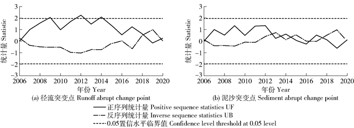
3.3 径流泥沙年际突变点分析通过Matlab软件对2006—2020年刘家沟小流域径流量及输沙量进行Mann-Kendall突变检验。小流域年径流量Mann-Kendall统计值Z=0.20,表明随时间增大小流域径流量呈增大趋势。当Z的绝对值≥1.28和≥1.64时,分别表示通过信度90%和95%显著性检验,因此年径流量没有通过90%的显著性检验,增加趋势不明显。如图 1a所示,正序列统计量UF值多数年份大于0,径流年际变化呈上升趋势;UF曲线与UB曲线在2006—2007年、2017—2018年和2019—2020年3个时段出现交叉点,位于2临界线之间,说明小流域径流在这3个时段发生突变。小流域径流量突变点主要发生在2018年,主要是2018年径流量较2017显著减少,由115.76万m3减至35.44万m3,2017—2018年降雨量明显减少,其变化是由于降雨变化的影响。根据年径流量突变特征,优化小流域水土保持措施布置,提升小流域水源涵养生态功能。

|
图 1 小流域年径流泥沙突变点检测 Fig. 1 Detection of abrupt change points of annual runoff and sediment in small watershed |
小流域年输沙量的Mann-Kendall统计值Z=0.10,随时间变化流域年输沙量有增加态势,增加趋势仍没有通过信度为90%的显著检验。如图 1b所示,UF曲线及UB曲线在2006—2007年、2012—2013年、2013—2015年、2016—2017年、2017—2019年和2019—2020年6个时段出现交叉点,位于信度线之间,说明小流域泥沙量在这6个时段内发生突变。输沙量突变点主要发生在2006、2012和2020年,其中2020年输沙量(1 304.57 t)较2019年(52.11 t)变化极大,主要由于“经开大道延伸段下穿道D377天然气管道迁改工程”建设活动产生了大量松散堆积物汇入小流域,同时改变了坡面产汇流条件,从而小流域形成了大部分输沙量,而降雨量波动则变为次要原因,可见小流域内人为扰动活动和土地利用类型变化对泥沙变化具有重要影响。总体看来,径流量与输沙量的突变发生时间一致(2006—2007年),但输沙量的突变点较径流量更多。
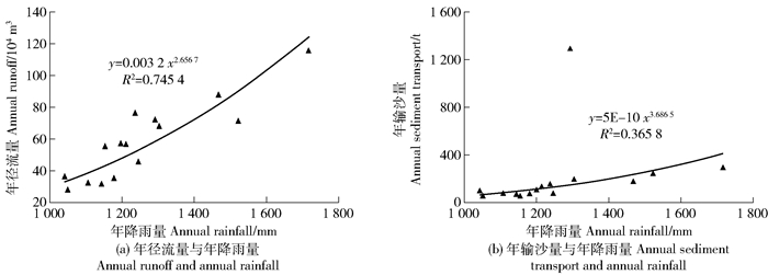
3.4 径流泥沙演变影响因素分析径流泥沙受降雨量影响为主,径流量、侵蚀模数与降雨量存在一定关系。对小流域2006—2020年径流量及年降雨量进行幂函数拟合分析,由图 2a可知,年径流量与年降雨量的拟合方程为y=0.003 2x2.656 7,年径流量与年降雨量呈显著相关(决定系数为0.745 4),表明年径流量与年降雨量间存在显著相关性,监测资料数据具有较强可靠性[18]。随年降雨量增加,年径流量趋于增加,其中最大年降雨量1 717.3 mm(2017年),最大年径流量115.76万m3(2017年),说明年径流量与降雨量最大值同步。总的来说,地表径流量大小与降雨量大小呈正相关,同期年降雨量逐年增加,小流域地表径流量随之增加,降雨量越大,则年径流量越大,降雨量与径流泥沙的相关性紧密。刘家沟小流域输沙量与降雨量关系如图 2b所示,采用幂函数对年输沙量及年降雨量进行拟合,拟合方程为y=5E-10x3.686 5,其中年输沙量与年降雨量拟合程度较低,但呈正向相关(决定系数为0.365 8),说明多沙年常出现丰水年,反之,少沙年则出现枯水年。随年降雨量增加,年输沙量呈增长趋势,其中最大年降雨量与最大年输沙量同步,分别为1 717.3 mm(2017年)和286.78 t(2017年)。总的来说,年降雨量增加引起地表径流量和输沙量增加,年降雨量与径流量相关性紧密,与年输沙量紧密性较小。

|
图 2 小流域径流泥沙与年降雨量关系 Fig. 2 Relationship between runoff, sediment and annual rainfall in small watershed |
根据径流泥沙年际突变点结果,以输沙量突变年份2012年为界,将研究时段划分为2个时期,分别拟合2006—2012年和2013—2020年平均年降雨量、径流量和输沙量关系(表 3)。2006—2012年,降雨量和输沙量、径流量和输沙量决定系数均大于0.7,而降雨量和径流量的决定系数仅为0.542 5,说明降雨量与输沙量的相关性密切,径流量与输沙量密切相关,而降雨量与径流量相关性较小,可能是因为土地利用方式改变的影响。2013—2020年降雨量与径流量呈明显正比变化关系,决定系数最高0.862 6,说明刘家沟小流域年降雨量与年径流量关系较密切,降雨量越大,径流量越大,且降雨量的增幅大于径流量的增幅。
| 表 3 不同时期径流泥沙拟合方程 Tab. 3 Fitting equation of runoff and sediment in different periods |
土地利用类型的改变会影响流域径流量及产沙量。刘家沟小流域年径流量及年输沙量峰值均发生在2017—2020年,而2006—2017小流域年径流量及年输沙量较低,除了降雨量较小影响外,主要是土地利用方式发生变化的影响。如表 4所示,2006—2017间刘家沟小流域耕地和园地面积显著减少,林地面积呈增长迅速,其中小流域内耕地面积比例由50.61%下降到16.46%。相反,林地面积由0.37 km2(22.56%)增加到1.14 km2(69.51%),其中2010—2017林地面积增加较明显,一定程度使小流域年输沙量降低。2006—2010年期间,小流域年径流量及年输沙量呈波动减小趋势,整体差异较小,主要因为2006年之后,小流域土地利用方式基本不变,耕地面积稍有减少,林地面积略有增加,降雨仍是影响该时期小流域水沙变化的主要因素,但由于降雨量达1 717.3 mm(最大),使得2017年径流量(115.76万m3)和年输沙量(286.78 t)仍较大。随着当地社会经济快速发展和城镇化程度增加,尤其城镇建设用地、生产建设项目开挖产生的松散工程堆积体等增加,人类活动对流域内径流量、泥沙量变化的影响程度增加,而小流域土地利用变化导致径流量、泥沙量的变化减少;观测期间耕地和林地所占比例较大,其次是园地、草地,建设用地和其他土地所占比例较小。其他因素(梯田、林草地等水土保持措施面积增加)对径流量影响小于对输沙量影响,降雨、土地利用类型、植被覆盖度是输沙量的主要影响因素。
| 表 4 刘家沟小流域土地利用类型变化 Tab. 4 Changes of land use types in Liujiagou small watershed |
1) 小流域年输沙量变异系数大于年径流量和年降雨量变化程度。小流域年均径流量、输沙量和洪峰流量分别为58.20万m3/s、206.00 t和12.49 m3/s,最大径流系数(0.38,2017年)为最小径流系数(0.16,2019年)的2.38倍。
2) 小流域径流量和输沙量均随时间呈总体增大趋势,两者突变发生时间一致。径流量显著突变点在2018年,而输沙量突变点发生在2006、2012和2020年,主要由于期间小流域内天然气建设工程的人为扰动活动引起的。
3) 年降雨量对小流域径流量的影响较大,对年输沙量影响不明显。年降雨量与年径流量呈显著相关(决定系数为0.745 4),年降雨量与输沙量呈正向相关(决定系数为0.365 8),表明刘家沟小流域监测资料数据质量良好。
4) 水土保持生态修复工程总体上降低小流域产流产沙量。小流域生态修复工程效应发挥年份与径流泥沙突变年份一致,降雨、土地利用类型、植被覆盖度是影响小流域输沙量的主要因素,应同步实时监测坡面水土保持措施对小流域径流泥沙影响的贡献。
| [1] |
袁静, 郜文旺, 袁文博. 典型对比小流域降水特征及其对径流泥沙的影响: 以南小河沟流域为例[J]. 中国水土保持, 2021(9): 43. YUAN Jing, HAO Wenwang, YUAN Wenbo. Precipitation characteristics of typical contrast small watershed and its impact on runoff and sediment: A case study of Nanxiaohegou watershed[J]. Soil and Water Conservation in China, 2021(9): 43. |
| [2] |
刘纪根, 任洪玉, 牛俊, 等. 紫色土区小流域侵蚀产沙对水土保持措施的响应[J]. 水土保持研究, 2018, 25(2): 29. LIU Jigen, REN Hongyu, NIU Jun, et al. Response of erosion and sediment yield to soil and water conservation measures in small watershed in purple soil region[J]. Research of Soil and Water Conservation, 2018, 25(2): 29. |
| [3] |
周添惠, 杨磊, 赵方凯, 等. 渭河源流域源汇景观演变对径流泥沙的影响研究[J]. 生态学报, 2022, 42(1): 58. ZHOU Tianhui, YANG Lei, ZHAO Fangkai, et al. Impacts of source and sink landscape dynamics on runoff and sediment watershed of the Weihe River[J]. Acta Ecologica Sinica, 2022, 42(1): 58. |
| [4] |
李景宗, 张永永, 赵帮元, 等. 皇甫川特拉沟小流域近期泥沙减少成因分析[J]. 人民黄河, 2018, 40(4): 1. LI Jingzong, ZHANG Yongyong, ZHAO Bangyuan, et al. Cause analysis of recent sediment reduction in Telagou Small Watershed of Huangfuchuan Basin[J]. Yellow River, 2018, 40(4): 1. |
| [5] |
姜德文. 水土保持强监管目标任务及方法探讨[J]. 中国水利, 2019(1): 13. JIANG Dewen. Objective tasks and methodologies for strengthening soil and water conservation monitoring and supervision[J]. China Water Resources, 2019(1): 13. |
| [6] |
郑江坤, 李静苑, 秦伟, 等. 川北紫色土小流域植被建设的水土保持效应[J]. 农业工程学报, 2017, 33(2): 141. ZHENG Jiangkun, LI Jingyuan, QIN Wei, et al. Effects of vegetation construction on soil and water conservation in small watershed of purplish soil region, northern Sichuan[J]. Transactions of the CSAE, 2017, 33(2): 141. |
| [7] |
李怡颖, 范继辉, 廖莹. 近60年来嘉陵江流域水沙变化特征[J]. 山地学报, 2020, 38(3): 339. LI Yiying, FAN Jihui, LIAO Ying. Variation characteristics of streamflow and sediment in the Jialing River Basin in the past 60 years, China[J]. Mountain Research, 2020, 38(3): 339. |
| [8] |
廖凯涛, 胡建民, 宋月君, 等. 南方红壤丘陵区流域植被景观格局变化及水沙响应关系[J]. 水土保持学报, 2019, 33(3): 36. LIAO Kaitao, HU Jianmin, SONG Yuejun, et al. Effects of vegetation landscape patterns on runoff and sediment in red soil hilly region of southern China[J]. Journal of Soil and Water Conservation, 2019, 33(3): 36. |
| [9] |
寇馨月, 姜学兵, 黄俊, 等. 红壤区小流域次降雨产流产沙因素分析及模型构建[J]. 水土保持通报, 2017, 37(6): 34. KOU Xinyue, JIANG Xuebing, HUANG Jun, et al. Analysis of factors affecting runoff and sediment yield and its modelling construction in individual rainfall in small watershed of red soil region[J]. Bulletin of Soil and Water Conservation, 2017, 37(6): 34. |
| [10] |
张富, 赵传燕, 邓居礼, 等. 祖厉河流域降雨径流泥沙变化特征研究[J]. 干旱区地理, 2018, 41(1): 74. ZHANG Fu, ZHAO Chuanyan, DENG Ju1i, et al. Change characteristics of the precipitation runoff and sediment discharge in Zulihe River Basin[J]. Arid Land Geography, 2018, 41(1): 74. |
| [11] |
姚文艺, 高亚军, 张晓华. 黄河径流与输沙关系演变及其相关科学问题[J]. 中国水土保持科学, 2020, 18(4): 1. YAO Wenyi, GAO Yajun, ZHANG Xiaohua. Relationship evolution between runoff and sediment transport in the Yellow River and related scientific issues[J]. Science of Soil and Water Conservation, 2020, 18(4): 1. |
| [12] |
冉大川, 张志萍, 罗全华, 等. 大理河流域1970—2002年水保措施减洪减沙效益深化分析[J]. 水土保持研究, 2011, 18(1): 17. RAN Dachuan, ZHANG Zhiping, LUO Quanhua, et al. More comprehensive analysis on benefits of flood and sediment reduction of soil and water conservation measures during1970 to 2002 in Dali River Basin[J]. Research of Soil and Water Conservation, 2011, 18(1): 17. |
| [13] |
李智广, 赵力毅. 小流域输沙模数多年总体状况的描述方法研究[J]. 水土保持通报, 2021, 41(4): 128. LI Zhiguang, ZHAO Liyi. A study on description methods of sediment transport modulus in small watershed[J]. Bulletin of Soil and Water Conservation, 2021, 41(4): 128. |
| [14] |
彭浩, 李忠武, 刘春, 等. 湘中低山丘陵区坡面产流输沙对降雨、土壤类型及水保措施的综合响应特征[J]. 水土保持学报, 2019, 33(2): 60. PENG Hao, LI Zhongwu, LIU Chun, et al. Comprehensive response characteristics of runoff and sediment yield on rainfall, soil type and water conservation measures in hilly area of central Hunan province[J]. Journal of Soil and Water Conservation, 2019, 33(2): 60. |
| [15] |
刘惠英, 鲁向晖, 张平仓, 等. 三峡库区香溪河流域水沙关系变化及其驱动因素[J]. 水土保持通报, 2015, 35(5): 17. LIU Huiying, LU Xianghui, ZHANG Pingcang, et al. Variation of runoff and sediment discharge and its driving factors in Xiangxi River Watershed in Three Gorges Reservoir Area[J]. Bulletin of Soil and Water Conservation, 2015, 35(5): 17. |
| [16] |
秦瑞杰, 陆广勇, 安乐平, 等. 水土保持措施对罗玉沟流域水沙变化的影响[J]. 中国水土保持, 2019(1): 19. QIN Ruijie, LU Guangyong, AN Yueping, et al. Effects of soil and water conservation measures on runoff and sediment changes in Luoyugou watershed[J]. Soil and Water Conservation in China, 2019(1): 19. |
| [17] |
叶晨, 张正栋, 张杰, 等. 华南湿热区小流域水沙变化及影响因子分析: 以五华河为例[J]. 长江流域资源与环境, 2017, 26(7): 1083. YE Chen, ZHANG Zhengdong, ZHANG Jie, et al. Analysis of runoff and sediment change and impact factor in the southern humid area river basin: A case study of Wuhua[J]. Resources and Environment in the Yangtze Basin, 2017, 26(7): 1083. |
| [18] |
陈瑾, 张佰林, 王琨. 安家沟流域地面监测数据质量及合理性评价[J]. 中国水土保持, 2018(9): 61. CHEN Jin, ZHANG Bailin, WANG Kun. Quality and rationality evaluation of surface monitoring data in Anjiagou watershed[J]. Soil and Water Conservation in China, 2018(9): 61. |
| [19] |
王淑慧, 苏伯儒, 王云琦, 等. 近16年三峡库区径流输沙变化分析[J]. 中国水土保持科学, 2021, 19(1): 69. WANG Shuhui, SU Boru, WANG Yunqi, et al. Change analysis of runoff and sediment in the Three Gorges Reservoir Region in recent 16 years[J]. Science of Soil and Water Conservation, 2021, 19(1): 69. |
| [20] |
张丹丹, 王冬梅, 汪西林. 广西桂林漓江滨岸带植被对地表产流产沙的影响[J]. 中国水土保持科学, 2016, 14(2): 81. ZHANG Dandan, WANG Dongmei, WANG Xilin. Influence of riparian vegetation on surface runoff and sediment in Li River of Guilin city[J]. Science of Soil and Water Conservation, 2016, 14(2): 81. |
| [21] |
朱楠, 马超, 王云琦, 等. 基于SWAT模型的不同土地利用结构对流域水沙的影响[J]. 中国水土保持科学, 2016, 14(4): 105. ZHU Nan, MA Chao, WANG Yunqi, et al. Effects of varied land use structures on runoff-sediment yield based on SWAT model[J]. Science of Soil and Water Conservation, 2016, 14(4): 105. |