2. 中国科学院地理科学与资源研究所 陆地水循环与地表过程重点实验室,100101,北京;
3. 国际泥沙研究培训中心/中国水利水电科学研究院,100048,北京;
4. 西北农林科技大学 水土保持研究所 黄土高原土壤侵蚀与旱地农业国家重点实验室, 712100,陕西杨凌;
5. 中国农业大学水利与土木工程学院,100083,北京;
6. 北京师范大学地理科学学部地理学院,100875,北京;
7. 首都师范大学地球空间信息科学与技术国际化示范学院,100048,北京
中国水土保持科学  2022, Vol. 20 2022, Vol. 20  Issue (3): 102-108. DOI: 10.16843/j.sswc.2022.03.013 Issue (3): 102-108. DOI: 10.16843/j.sswc.2022.03.013 |
我国黄土高原地区地形破碎、土质疏松、植被稀疏,暴雨集中在汛期,水土流失剧烈,是我国乃至世界土壤侵蚀最为严重的区域。20世纪60—70年代,黄土高原土壤侵蚀模数>5 000 t/(km2·a)的区域占黄土高原总面积的42.0%,其中>1万t/(km2·a)的区域占黄土高原总面积的18.4%[1]。新中国成立以来,黄土高原是我国水土流失治理重点区域,主要水土流失治理措施包括封禁、造林、种草、建梯田、淤地坝等,其中,淤地坝是黄土高原地区人民群众在长期同水土流失斗争实践中创造的一种既拦截泥沙和保持水土,又是淤地造田和增产粮食的水土保持工程措施。
1 淤地坝和谷坊的概念淤地坝是黄土高原地区人民群众首创的一项独特的水土保持工程措施,是指在水土流失地区各级沟道中,以拦泥淤地为目的而修建的坝工建筑物,其拦泥淤成的地叫坝地。淤地坝在不同专业名词字典或国家标准中定义相似。水利科技名词审定委员会和林学名词审定委员会将淤地坝定义为“横筑于沟道用以拦泥淤地的坝工建筑物”[2-3];土壤学名词审定委员会[4]将淤地坝定义为“拦蓄流域侵蚀产沙物质并用于造田开发农地而修筑的坝库工程”。在住房和城乡建设部[5]颁布的国标中,淤地坝是指在多泥沙沟道修建的以控制侵蚀、拦泥淤地、减少洪水和泥沙灾害为主要目的工程设施,其总库容≤500万m3,坝高≤30 m。淤地坝包括坝体、溢洪道、放水建筑物“三大件”,坝体主要为黄土均质坝,也有少量土石混合坝、塑性心墙坝和砌石拱坝。淤地坝主要功能为抬高沟道侵蚀基准面、防治水土流失、滞洪、拦泥、淤地,在减少入黄泥沙、合理利用水资源、改善当地生产生活条件、建设高产稳产的基本农田、促进当地社会经济等方面有着十分重要的意义。
与淤地坝相似,谷坊也是治理沟道土壤侵蚀的重要水土保持工程措施。谷坊是修建在山地丘陵侵蚀沟内的土或石坝,有土谷坊、石谷坊、植物谷坊等类型。水利科技名词审定委员会[2]将谷坊定义为“用不同材料(土、石、混凝土等)修筑的 < 5 m的拦沙坝,主要作用在于防止沟底下切。”。土壤学名词审定委员会[4]在《土壤学名词》(第2版)中,将谷坊定义为“沟道内修筑的用于蓄水拦沙的障碍物。高≤5 m,类似小型坝体。”。林学名词审定委员会[3]在《林学名词》(第2版)中,将谷坊定义为“山区沟道内为防止沟床冲刷及泥沙灾害而修筑的横向挡拦建筑物。”。由此可见,谷坊的坝高一般≤5 m,主要功能是蓄水拦沙,抬高侵蚀基面,防止沟底下切、沟头前进、沟岸扩张;减缓沟道纵坡,减小山洪流速,减轻山洪或泥石流危害;拦蓄泥沙,使沟底逐渐台阶化,为利用沟道土地发展生产创造条件。谷坊工程应在以小流域为单元的全面规划、综合治理中,与沟头防护、淤地坝等沟壑治理措施相互配合,获取共同控制沟壑侵蚀的效果[6]。
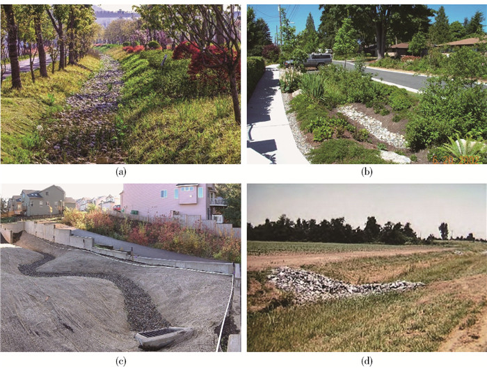
2 Check dam的内涵国外check dam与我国淤地坝显著不同,并且关于check dam的认识,美国与欧洲也存在一定差异。从美国不同地区土壤侵蚀控制和泥沙拦截的操作手册来看,关于check dam的认知基本趋同,较为一致。Check dam的定义为A small temporary barrier, grade control structure or dam constructed across a swale, drainage ditch, or area of concentrated flow[7]。由此可见,在美国,check dam是小型的,甚至临时的,一种降低流速、减缓侵蚀、拦截泥沙的小型临时性拦水坝。Check dam的坝高低矮,通常最大坝高 < 0.61 m[8-14]或者0.90 m[15-18]。美国check dam控制的最大汇水面积标准较多,不同区域其标准并不完全统一。例如,0.2[10-11]、0.4[12]、0.8[8, 13]、和4 hm2[16, 18-19]等,其中,4 hm2为美国check dam最大汇水面积的最高标准。“check dam”规模通常较小,常常修建在植草沟、排水沟中,用于减少径流中的泥沙和污染物[20]。例如,check dam通常被建设为植草沟或生态洼地,具有过滤泥沙、净化水质的人工排水沟渠(图 1a和b)。由此可见,美国的check dam是一个体量很小的沟道水沙拦截工程,不仅远小于我国的淤地坝,甚至也远小于我国的谷坊。

|
图 1 美国check dam常作为植被过滤带 Fig. 1 Check dams commonly designed as bioswales in USA |
在欧洲,check dam作为稳定山区河流一种治理措施,在山区被广泛修建的历史可以追溯到19世纪。通常等间隔连续修建多个,是一个古老的流域治理技术措施。Check dam常修建在沟底用于控制流速、保持土壤和改善土地,作为修建条件困难、治理延迟、天气条件不允许或工程资金不足而实施的一种临时治沟工程措施,也常以大型永久堤坝工程或土壤控制工程建设过程中以降低坡降为主要功能的临时辅助工程出现。陡峭山区河流的流速非常快,常需修建小间距台阶式check dam体系来降低流速,通过阻止沟头溯源侵蚀、下切侵蚀和两岸侧蚀,进而提升沟道抗蚀能力,进一步起到防治山洪泥石流灾害作用。从规模上来看,欧洲check dam与我国谷坊很相似,坝高通常2~3 m,< 5 m,但功能与谷坊存在一些差异,而与我国淤地坝完全不同。欧洲check dam多用于山地山洪泥石流灾害治理,而不具有拦沙造地用于农业耕种的功能,而我国谷坊除了减少沟道侵蚀之外,还具有一定拦沙造地、开展农业耕作的用途。
3 Check dam与淤地坝、谷坊的比较 3.1 Check dam与淤地坝淤地坝是在水土流失严重地区,用于拦泥造地而横建于沟道中的水工建筑物,主要分布于陕甘晋蒙等黄土高原沟壑区。一条沟内修建多个淤地坝是黄土高原水土流失严重地区重要而独特的治沟工程体系,主要目的是控制侵蚀、滞洪拦泥、淤地造田、改善交通。淤地坝属于水土保持工程措施,绝大多数都是均质土坝,主要目的通常不包括蓄水,在初期拦沙造地阶段蓄水时常以低位蓄水为主;而水库属于水利工程,多是土石坝,主要功能是削峰蓄水,而拦蓄泥沙不是水库主要功能。从功能上看,国外check dam功能主要集中在控制侵蚀、拦截泥沙,发挥山地灾害防治功能,其中美国check dam还具有增加径流渗透、净化水质的功能,但它们都不具有淤地造田、扩大农业生产规模和提高粮食产量的功能,这与我国淤地坝存在明显的功能差异。
从坝高来看,在水利部2008年颁布的GB/T 16453.3—2008《水土保持综合治理技术规范——沟壑治理技术》中,将淤地坝分为3种类型[6]:1)小型淤地坝,一般坝高5~15 m,库容1万~10万m3,淤地面积0.2~2 hm2;2)中型淤地坝,一般坝高15~25 m,库容10万~50万m3,淤地面积2~7 hm2;3)大型淤地坝,一般坝高>25 m,库容50~500万m3,淤地面积>7 hm2。从体量上可见,中国淤地坝比西方check dam规模大的多,二者差异很大。我国淤地坝坝高通常>5 m,< 5 m的就划分为谷坊,而美国check dam通常控制面积 < 4 hm2,坝高≤20.61 m[21-22],而欧洲的check dam坝高通常2~3 m,基本<5 m[23-27]。
3.2 Check dam与谷坊谷坊在中国也常被译为check dam,是在易受侵蚀的沟道中,为了固定沟床而修筑的土、石建筑物,在中国分布广泛。谷坊规模尺寸比淤地坝小,坝高一般为1~3 m,最高5 m,库容 < 0.5万m3、淤地面积 < 0.2 hm2。Check dam常修建在排水沟、洼地、沟道,通过阻滞径流、降低沟道比降而降低流速,增加径流入渗,进而减少沟道侵蚀(图 1c和d)。Check dam有时候也会拦截一些泥沙,但check dam绝不是以拦截泥沙为基本功能的治理设施。当check dam拦截来自上游碎石、凋落物、叶子等物质超过坝高1/2时,通常要进行清理工作。有时为了防止沟道长草壅水和拦截泥沙,还需要对沟道进行除草管理。Check dam需要维护和清淤管理[21],这与我国将淤地坝淤地耕种作为建设淤地坝主要目的差别很大。
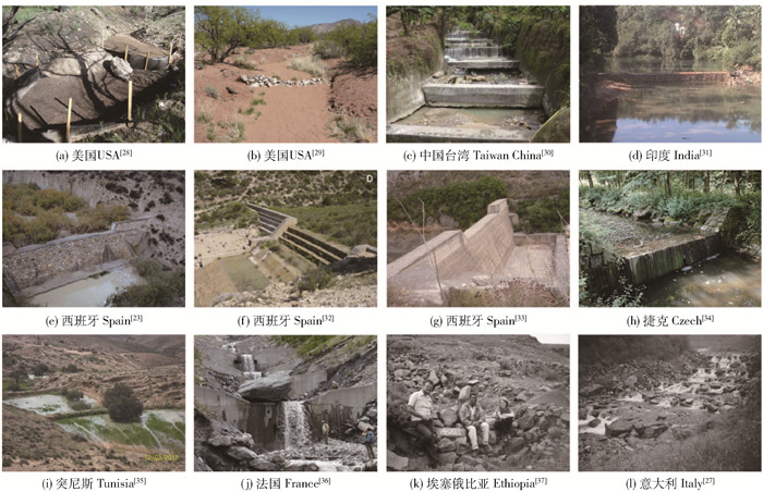
从尺寸看,我国谷坊远比坝高 < 0.60 m的美国check dam规模大的多(图 2a和b),其拦沙造地种植农作物的主要功能也非美国check dam所具有。例如,Nichols等[22]在美国亚利桑那州研究的27个check dams,坝高范围为0.15~0.60 m。从规模上来看,欧洲、非洲和其他亚洲国家和地区的check dam坝高多以2~3 m为主,通常 < 5 m(图 2c~l),与我们国家谷坊非常相似。在西班牙的check dam相关研究文献可知,其平均坝高通常在2~3 m范围。例如,Castillo等[23]研究中平均坝高为(2.9±0.7) m(N=36),Remâtre等[24]中平均坝高(3.03±2.66) m(N=82),Mongil-Manso等[25]中平均坝高(2.64±0.91)m(N=30)以及Díaz-Gutiérrez等[26]研究中“check dams”坝高(2.07±1.14) m(N=113)。Lenzi等[27]在意大利研究中check dams的坝高为(2.51±0.64)m(N=29),而Akita等[38]在日本的研究中,check dams的坝高与其相似,高度为(2.53±0.51) m(N=10)。我国淤地坝的坝高通常要>5 m而 < 30 m,而坝高 < 5 m的为谷坊,而欧洲check dam的坝高通常 < 5 m,以2~3 m为主,因此,用check dam与我国的谷坊更接近。

|
图 2 Check dams景观图 Fig. 2 Landscapes of check dams |
在黄土高原淤地坝学术论文报道中,通常使用check dam或者check-dam作为淤地坝的英文专业术语。其实,从上文论述可见,“check dam”与我国黄土高原的淤地坝相差甚大,属于专业术语的误用。除此之外,淤地坝也常被译为warping dam、silt dam、和soil-retaining dam等,它们都反映了淤地坝的拦截泥沙重要功能,但缺乏对拦截泥沙造地,用于农业生产的重要功能表述。在相关行业规范、标准等文件中,淤地坝常被翻译为silt storage dam for farmland building [3]、warp land dam[39]、silt storage dam for farmland construction[2]、check dam for building farmland[40]或check dam for farmland forming[5, 41],这些翻译都着重增加了拦沙造地的重要内涵。但它们有3个明显不足:一是淤地坝英文翻译尚未定型,存在多种翻译,相互差异较大,并不统一;二是英文翻译过长,并不是一个简短易用的专业术语,并不便于使用;三是常使用了与淤地坝内涵显著不同的check dam,其实,二者存在明显差异。中国学者在用英文报道我国淤地坝方面的工作时,正因为缺少简便易懂易用的与淤地坝所对应的英文专业术语,所以常使用内涵与谷坊较为一致的check dam作为淤地坝的专业术语。这并不能真实地反映我国淤地坝的尺寸规模和功能,也削弱了国外同行对我国在黄土高原所长期开展的大规模淤地坝建设工作的客观认识。
淤地坝是我国黄土高原地区具有鲜明地域特色的水土流失治理工程措施的中文名,其工程数量和拦截泥沙量巨大,对黄土高原水土流失治理、减少入黄泥沙量以及提高黄土高原粮食产量都做出了重要贡献[42]。目前,还没有能很好地与之相对应的英文专业术语,目前很有必要正式提出简便易用的淤地坝英文专业术语,用以表达我国淤地坝这一独特的水土保持工程措施。在此,建议借用淤地坝汉语拼音,提出采用Yudiba dam作为淤地坝的英文专业术语。Yu体现了拦截沟道泥沙、淤积成地的功能,di是土地、耕地意思,代表了造地用于农业生产,ba是为了保持借用淤地坝汉语拼音的完整性,也便于口语交流过程中识别。dam标识出淤地坝是坝的一种类型,一种沟道拦截泥沙工程措施。
Yudiba dam简明易记,较为准确地体现了淤地坝主导功能,与淤地坝主要分布在土壤侵蚀剧烈的黄土高原地区现实相一致,具有鲜明中国地域特色,有助于西方学术界更好地理解我国淤地坝建设工作。Yudiba dam定义为用于拦截泥沙、淤地造田开发农地的坝库工程,坝高通常为5~30 m。英文释义为Yudiba dam is a dam built for intercepting sediment and developing farmland. It is a typical engineering measure to control gully soil erosion and trap sediment in severe soil erosion area such as the Chinese Loess Plateau. The dam height is usually higher than 5 m and lower than 30 m。淤地坝是流域水土流失治理过程中一种重要的沟道治理工程措施,不仅具有拦截上游泥沙,抬高侵蚀基准面,降低沟道比降,减缓沟道侵蚀的功能,并且还具有拦沙造地,增加耕地面积,提高粮食生产的功能。值得说明的是,在2次沙龙研讨过程中,笔者提出“Yudiba dam”作为淤地坝英文译法的观点并未有得到广泛一致认同。不同学者从各自角度也提出了与之不同的淤地坝英文翻译法,其中,“Yudiba”“Yudi dam”“Yudidam”“Siltup farmland dam”等皆具有一定的代表性,以供商榷。
5 结论淤地坝是黄土高原治理侵蚀输沙的主要工程措施,对黄河中游输沙锐减发挥重要作用,而淤地坝拦沙造地是黄土高原解决粮食安全问题的重要途径。近30年来,中国学者在黄土高原地区发表了大量有关淤地坝的英文论文,淤地坝被广泛地误用为“check dam”,因二者从规模、功能上都存在显著差异,并不能真实地反映我们国家淤地坝的规模和功能。考虑到黄土高原淤地坝的空间分布之广,数量之多,拦截泥沙之巨量,为廓清黄土高原淤地坝在国际学术交流的误区,我们建议使用中文拼音Yudiba dam表达黄土高原这种控制侵蚀、拦截泥沙造地,发展农业生产的这类水土保持工程措施。采用Yudiba dam作为黄土高原淤地坝这一特殊水土流失治理工程措施的英文翻译术语,可以更准确、更客观地宣传我们长久以来在黄土高原所做的水土流失治理工作。
后记:论文是2018年11月15日第11次和2021年4月28日第15次土壤侵蚀与水土保持沙龙与会专家讨论结果。该沙龙每半年在京举行一次,现已举办16次。
| [1] |
王万忠, 焦菊英. 黄土高原侵蚀产沙强度的时空变化特征[J]. 地理学报, 2002, 57(2): 210. WANG Wanzhong, JIAO Juying. Temporal and spatial variation features of sediment yield intensity on Loess Plateau[J]. Acta Geographica Sinica, 2002, 57(2): 210. |
| [2] |
水利科技名词审定委员会. 水利科技名词[M]. 北京: 科学出版社, 1997: 147. Approval Committee of Water Conservancy Terms. Chinese terms in water conservancy[M]. Beijing: Science Press, 1997: 147. |
| [3] |
林学名词审定委员会. 林学名词[M]. 2版. 北京: 科学出版社, 2016: 167. Approval Committee of Forest Science Terms. Chinese terms in forest science[M]. 2nd ed. Beijing: Science Press, 2016: 167. |
| [4] |
土壤学名词审定委员会. 土壤学名词[M]. 2版. 北京: 科学出版社, 1998: 102. Approval Committee of Soil Science Terms. Chinese terms in soil science[M]. 2nd ed. Beijing: Science Press, 1998: 102. |
| [5] |
住房和城乡建设部. 水土保持工程设计规范: GB 51018—2014[S]. 北京: 中国计划出版社, 2015: 2. Ministry of Housing and Urban-Rural Development. Code for design of soil and water conservation engineering: GB 51018—2014[S]. Beijing: China Planning Press, 2015: 2. |
| [6] |
中华人民共和国水利部. 水土保持综合治理技术规范——沟壑治理技术: GB/T16453.3—2008[S]. 北京: 中国标准出版社, 2008: 3. Ministry of Water Resources of People's Republic of China. Technical specification for comprehensive control of soil and water conservation: Gully control technology: GB/T 16453.3—2008[S]. Beijing: China Standard Press, 2008: 3. |
| [7] |
Tennessee Department of Environment and Conservation (TN-DEC). Erosion and sediment control handbook: A stormwater planning and design manual[S/OL]. 4th ed. 2012: 152. [2022-03-25]. https://tnepsc.org/TDEC_EandS_Handbook_2012_Edition4/TDEC%20EandS%20Handbook%204th%20Edition.pdf.
|
| [8] |
Massachusetts Department of Environmental Protection (MA-DEP). Massachusetts erosion and sediment control guidelines for urban and suburban areas: A guide for planners, designers and municipal officials[S]. Boston: Massachusetts Department of Environmental Protection, Original Print: March 1997; Reprint: May 2003: 65.
|
| [9] |
Maryland Department of the Environment Water Management Administration (MD-DEWMA), Natural Resources Conservation Service (NRCS), Maryland Association of Soil Conservation Districts (M-D-ASCD) Maryland standards and specifications for soil erosion and sediment control[S/OL]. 2011: D5. [2022-03-25]. https://mde.maryland.gov/programs/water/StormwaterManagementProgram/Documents/2011%20MD%20Standard%20and%20Specifications%20for%20Soil%20Erosion%20and%20Sediment%20Control.pdf.
|
| [10] |
North Carolina Sedimentation Control Commission (NC-SCC), the North Carolina Department of Environment and Natural Resources (NC-DENR), the North Carolina Agricultural Extension Service (N-C-AES). NC erosion and sediment control planning and design manual[S/OL]. 2013: 6.83.1. [2022-03-25]. https://deq.nc.gov/media/636/download.
|
| [11] |
North Carolina Department of Transportation (NC-DT). Erosion and sediment control design and construction manual[S]. Morrisville: URS Corporation-North Carolina, 2015: 4.
|
| [12] |
LEERSNYDER H, BUNTING K, PARSONSON M, et al. Erosion and sediment control guide for land disturbing activities in the Auckland region[S]. Auckland: Beca Ltd, 2016: 51.
|
| [13] |
New York State Department of Environmental Conservation (NYS-DEC). New York state standards and specifications for erosion and sediment control[S/OL]. 2016: 3.2. [2022-03-25]. https://www.dec.ny.gov/chemical/29066.html.
|
| [14] |
District of Columbia Department of Energy & Environment (DC-DEE), Watershed Protection Division (WPD). Erosion and sediment control manual[S/OL]. Ellicott city: Center for Watershed Protection, 2017: 127.
|
| [15] |
City of Memphis Division of Public Works and Division of Engineering (CMD-PWDE), Shelby County Public Works Department (SC-PWD). Storm water management manual. Volume 3: Best management practices manual[S]. Memphis: City of Memphis Division of Public Works, 2006: ES-13-4.
|
| [16] |
Mississippi Department of Environmental Quality (MS-DEQ). Erosion control, sediment control and stormwater management on construction sites and urban areas. Volume 1: Erosion and sediment control practices[S/OL]. 2011: 4. [2022-03-25]. https://www.mdeq.ms.gov/wp-content/uploads/2017/05/Volume_1.pdf.
|
| [17] |
Watershed Division Department of Environmental Services (WD-DES), City of Gresham, Oregon. Erosion prevention and sediment control manual[S/OL]. 2011: 5. [2022-03-25]. https://greshamoregon.gov/WorkArea/DownloadAsset.aspx?id=2273.
|
| [18] |
Illinois State Toll Highway Authority (ILS-THA). Erosion control and landscape manual[S]. Downers Grove: Illinois State Toll Highway Authority, 2020: 65.
|
| [19] |
Government of Alberta Transportation (GAT). Erosion and sediment control manual[R]. Edmonton: Government of Alberta Transportation, 2011: 7.
|
| [20] |
MARSH W M. Landscape planning: Environmental applications[M]. 5th ed. Danvers, MA: John Wiley & Sons, Inc, 2010: 267.
|
| [21] |
Iowa Statewide Urban Design and Specifications (SUDAS). Design manual: Erosion and sediment control[S]. Ames, IA: Institute for Transportation at Iowa State University, 2013: 7E-7.
|
| [22] |
NICHOLS M H, POLYAKOV V O, NEARING M A, et al. Semiarid watershed response to low-tech porous rock check dams[J]. Soil Science, 2016, 181(7): 275. DOI:10.1097/SS.0000000000000160 |
| [23] |
CASTILLO V M, MOSCH W M, GARCIA C C, et al. Effectiveness and geomorphological impacts of check dams for soil erosion control in a semiarid Mediterranean catchment: El Carcavo (Murcia, Spain)[J]. Catena, 2007, 70(3): 416. DOI:10.1016/j.catena.2006.11.009 |
| [24] |
REMAȊTRE A, VAN ASCH T W J, MALET J-P, et al. Influence of check dams on debris-flow run-out intensity[J]. Natural Hazards and Earth System Sciences, 2008, 8(6): 1403. DOI:10.5194/nhess-8-1403-2008 |
| [25] |
MONGIL-MANSO J, DIAZ-GUTIERREZ V, NAVARRO-HEVIA J, et al. The role of check dams in retaining organic carbon and nutrients. A study case in the Sierra de vila mountain range (central Spain)[J]. Science of the Total Environment, 2018, 657: 1030. |
| [26] |
DÍAZ-GUTIÉRREZ V, MONGIL-MANSO J, NAVARRO-HEVIA J, et al. Check dams and sediment control: final results of a case study in the upper Corneja River (central Spain)[J]. Journal of Soils and Sediments, 2018, 19: 451. |
| [27] |
LENZI M A, COMITI F. Local scouring and morphological adjustments in steep channels with check-dam sequences[J]. Geomorphology, 2003, 55(1/4): 97. |
| [28] |
ROBICHAUD P R, STORRAR K A, WAGENBRENNER J W. Effectiveness of straw bale check dams at reducing post-fire sediment yields from steep ephemeral channels[J]. Science of the Total Environment, 2019(676): 721. |
| [29] |
POLYAKOV V O, NICHOLS M H, MCCLARAN M P, et al. Effect of check dams on runoff, sediment yield, and retention on small semiarid watersheds[J]. Journal of Soil and Water Conservation, 2014, 69(5): 414. DOI:10.2489/jswc.69.5.414 |
| [30] |
LIN Bingshyan, YEH Chaohsien, LIEN Huipang. The experimental study for the allocation of ground-sills downstream of check dams[J]. International Journal of Sediment Research, 2008, 23(1): 28. DOI:10.1016/S1001-6279(08)60003-7 |
| [31] |
BALOONI K, KALRO A H, KAMALAMMA A G. Community initiatives in building and managing temporary check-dams across seasonal streams for water harvesting in South India[J]. Agricultural Water Management, 2008, 95(12): 1314. DOI:10.1016/j.agwat.2008.06.012 |
| [32] |
BOIX-FAYOS C, DE VENTE J, MARTÍNEZ-MENA M, et al. The impact of land use change and check-dams on catchment sediment yield[J]. Hydrological Processes, 2008, 22(25): 4922. DOI:10.1002/hyp.7115 |
| [33] |
BUSSI G, RODRÍGUEZ-LLOVERAS X, FRANCÉS F, et al. Sediment yield model implementation based on check dam infill stratigraphy in a semiarid Mediterranean catchment[J]. Hydrology and Earth System Sciences, 2013, 17(8): 3339. DOI:10.5194/hess-17-3339-2013 |
| [34] |
GALIA T, ŠKARPICH V, RUMAN S, et al. Check dams decrease the channel complexity of intermediate reaches in the western Carpathians (Czech Republic)[J]. Science of the Total Environment, 2019(662): 881. |
| [35] |
CASTELLI G, OLIVEIRA L A A, ABDELLI F, et al. Effect of traditional check dams (jessour) on soil and olive trees water status in Tunisia[J]. Science of the Total Environment, 2019(690): 226. |
| [36] |
PITON G, CARLADOUS S, RECKING A, et al. Why do we build check dams in Alpine streams? An historical perspective from the French experience[J]. Earth Surface Processes and Landforms, 2016, 42: 91. |
| [37] |
NYSSEN J, VEYRET-PICON M M, POESEN J, et al. The effectiveness of loose rock check dams for gully control in Tigray, northern Ethiopia[J]. Soil Use and Management, 2006, 20(1): 55. DOI:10.1111/j.1475-2743.2004.tb00337.x |
| [38] |
AKITA H, KITAHARA H, ONO H. Effect of climate and structure on the progression of wooden check dam decay[J]. Journal of Forest Research, 2014, 19(5): 450. DOI:10.1007/s10310-013-0434-x |
| [39] |
林学名词审定委员会. 林学名词[M]. 北京: 科学出版社, 1989: 29. Approval Committee of Forest Science Terms. Chinese terms in forest science[M]. Beijing: Science Press, 1989: 29. |
| [40] |
水利部. 水坠坝技术规范: SL302—2004[S]. 北京: 中国水利水电出版社出版, 2004: 2. Ministry of Water Resources. Technical specification for sluicing-siltation earth dam: SL302—2004[S]. Beijing: China Water & Power Press, 2004: 2. |
| [41] |
黄河中上游局. 淤地坝技术规范(报批稿)[S]. 北京: 中国水利出版社, 2019: 2. Upper and Middle Yellow River Bureau (UMYRB), YRCC. Technical specification of check dam for building farmland (Approval document)[S]. Beijing: China Water and Power Press, 2019: 2. |
| [42] |
XIN Zhongbao, YU Bofu, HAN Yuguo. Spatiotemporal variations in annual sediment yield from the middle Yellow River, China, 1950-2010[J]. Journal of Hydrologic Engineering, 2015, 20(8): 04014090. DOI:10.1061/(ASCE)HE.1943-5584.0001113 |