-
项目名称
- 国家自然科学基金项目"亚热带高原岩溶区陆地植被-湖泊湿地间的水文协同效应观测研究"(41761105)
-
第一作者简介
- 丁文荣(1979—), 男, 博士研究生, 副教授。主要研究方向: 水文与水资源。E-mail: dingwenrong@163.com
-
文章历史
-
收稿日期:2020-05-08
修回日期:2021-05-13
气候变异及其联动效应是现今全人类面临的主要生态环境问题,在联合国政府间气候变化专门委员会最新的评估报告中提出,自1901年以来的100多年间,全球地表平均温度提升0.85 ℃,变暖幅度自20世纪80年代以来呈显著的加速态势[1]。北方的沙漠化、南方的石漠化以及黄土高原的水土流失,构成了我国的3大生态灾害。其中,中国南方岩溶区是全球最典型的出露、半出露型岩溶区,也是石漠化危害程度最为严峻的生态区域[2]。气候因素是造成或加剧石漠化的重要外在因素,而石漠化过程则反过来恶化局地气候,从而形成恶性循环[3-4]。由此,针对气候变化与石漠化关系的研究已成为岩溶区生态环境研究的重要内容[5]。
目前,许多学者认为岩溶石漠化过程及等级的空间分布与下垫面的物质组成和气候(尤其是降雨量)的空间变化存在着密切的联系[6],自然气候要素特别是暴雨为岩溶石漠化的发生发展提供直接的水动力条件,驱动作用随着降雨强度的增加而加强[7],然而岩溶石漠化对强降雨过程的响应存在一定的滞后性[8];反之,岩溶石漠化过程改变局地气候,如岩溶石漠化区裸地的光照强度、大气温度和土壤温度均明显高于非石漠化、潜在石漠化土地,而相对湿度则相反,且岩溶石漠化区各指标日变化更为剧烈,气候趋于干热化[9-11]。此外,随着石漠化综合治理时间持续,植被结构得到改善,小气候效应逐渐凸显,表明植被恢复对遏止、逆转石漠化过程是有效的[12-13]。然而,在区域尺度上,气候变化与岩溶石漠化是否对降水量、降水时间、降水级别等特征造成影响仍然不明确。鉴此,笔者基于我国西南甄选非岩溶区及岩溶石漠化区典型站点的历史监测数据,采用数理分析法及类比法,揭示气候变化与岩溶石漠化影响下的降水特征变化规律,从而为中国岩溶石漠化区生态环境保育修复提供科学参考。
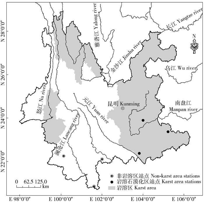
1 研究区概况云南省岩溶分布广泛,全省碳酸盐岩的出露面积高达11万2 100 km2,分布于滇中、滇东南、滇东北、滇西和滇西北5个片区,其中滇东南岩溶区是省内岩溶分布最广及石漠化程度最为严重的区域。而西双版纳州和普洱市作为典型的非岩溶区,无石漠化分布。鉴此,笔者以稳定性、资料连续性为原则,在剔除迁移较大及缺测较多的站点后,分别获得上述非岩溶区和岩溶区各3个站点(图 1)1959—2017年的逐日降水量数据作为研究资料。
|
图 1 非岩溶区、岩溶石漠化区气象站点的分布[地图审图号(GS(2008)1373号)] Fig. 1 Distribution of meteorological stations in non-karst area and karst rocky desertification area [Map review No. (GS (2008) No. 1373)] |
研究的核心数据来源于国家气象信息中心(http://data.cma.cn)和云南省呈贡区气象局。在数据分析前,提取站点周边3 km内植被状况作对比(表 1),并对数据进行统一的质量控制,包括气候学界限值检验、气候极值检验和内部一致性分析。结果表明:所使用站点的观测数据均在气候学界限值之内,没有超过气候极值,6个站点的内部一致性检验的综合信度CR系数为0.85,超过0.7的可接受水平。
| 表 1 气象站地理位置及周边环境 Tab. 1 Geographical locations and surrounding environment of meteorological stations |
参考符娇兰等[14]的划分方法,在分析降雨时间、最长持续干旱时间、最长持续降水时间变化时,以日降水量≥1 mm为阈值标准。进行各量级降雨的分析时,以气象部门雨量级别划分标准为依据,小雨:24 h降雨量 < 10 mm;中雨:10 mm≤24 h降雨量 < 25 mm;大雨:25 mm≤24 h降雨量 < 50 mm;暴雨:50 mm≤24 h降雨量 < 100 mm)。
降水特征的变异通过降水时间序列的变化来揭示,其中趋势分析采用气象学领域常用的线性倾向估计法[15],计算公式为:
| ${Y_i} = {a_1}{x_i} + b\;\left( {i = 1, 2, \ldots , n} \right) 。$ | (1) |
式中:Yi为待分析的降水数据;xi为时间序列;a1为线性趋势项;b为待定常数。如计算结果a1为正值,表示降水数列呈增加趋势,反过来为减少的趋势,并指定a1×10为降水数列每10 a的变化幅度。
然后,采用Mann-Kendall非参数检验法对降水序列的变化趋势进行显著性检测,该检验法不要求待分析降水数据遵从特定的统计学分布,也不受少数异常值的干扰,适用于非正态分布数据的分析[16]。
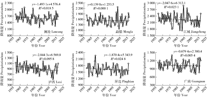
3 结果与分析 3.1 年降水量变化受印度洋、太平洋季风环流的共同控制,云南省降水具有季风区降水的显著特点。图 2分别为云南非岩溶区、岩溶石漠化区1959年以来年降水量的变化情况,可见,研究时段内各站点降水量年际波动明显,这反映出季风区降水的典型特征。其中非岩溶区澜沧、勐腊和江城年降水量变化速率分别为-1.493 1、0.139 0和-2.047 6 mm/a,岩溶区石漠化区泸西、屏边和广南的年降水量变化速率则分别为-2.844 3、-1.870 4和-0.679 4 mm/a。可见,所选站点中除了非岩溶区勐腊降水量有微弱增加趋势外,其余站点均呈现出减少趋势。
|
图 2 非岩溶区、岩溶石漠化区年降水量的变化趋势 Fig. 2 Change trend of annual precipitation in non-karst and karst area |
从非石漠化、岩溶石漠化2种下垫面各站点年降水量的变化速率对比来看,可以发现岩溶石漠化区降水过程的平均变化速率为-17.98%,较非岩溶区的-11.34%更明显,减少趋势也更加突出。然而,对上述所有站点进行趋势显著性检验后发现,在所有站点中只有泸西站的降水量变化趋势达到0.05的置信水平。
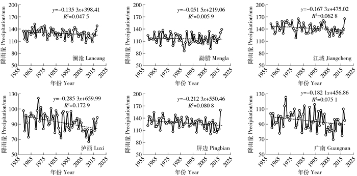
3.2 降雨时间变化研究以日降水量≥1 mm为统计标准,分别计算研究区各站降水时间的变化趋势(图 3),可见,研究时段内非岩溶区、岩溶石漠化区所有6个站点的降雨时间均呈现出减少的趋势,非岩溶区澜沧、勐腊、江城的降水时间变化速率分别为-0.135 3、-0.051 5和-0.167 3 d/a,而岩溶石漠化区泸西、屏边和广南则为分别为-0.285 3、-0.212 3和-0.182 1 d/a。岩溶石漠化区降雨时间的平均减少幅度为-0.225 d/a,较非岩溶区(-0.118 d/a)更大;但是,对6个站点的变化趋势进行显著性检验后可以发现,在所有站点中同样仅有石漠化区泸西站的减少速率达到0.05的置信水平。
|
图 3 非岩溶区、岩溶石漠化区年降水时间变化趋势 Fig. 3 Changing trends of annual rainy days in the non-karst area and karst rocky desertification area |
前期研究案例表明,气候变化不仅会引起降水量在时程分配上的变化,也会诱发降水级别的改变[17]。本研究在划分雨量级别的基础上,分别对研究区6个站点不同雨量级占年降水总量的比例及在研究时段内的演变趋势进行了计算(表 2),可见,对于小雨、中雨、大雨和暴雨4种降雨级别,尽管不同站点各量级降雨的变化规律不明显,但总体来看,中雨所占比例最高(均值34.04%)而暴雨最低(均值15.08%)。
| 表 2 非岩溶区、岩溶石漠化区不同雨级降水量变化趋势 Tab. 2 Change trends of different rainfall grades in non-karst and karst rocky desertification areas |
对于不同的降雨级别而言,小雨级别除岩溶石漠化区泸西站以外均为减少趋势,中雨级别除非岩溶区江城站外均为减少的趋势,但是大雨和暴雨降水级别则向增加趋势发展,这是全球气候变化背景下区域响应的结果[18-19]。此外,由表 2可知,尽管强降水尤其是暴雨主要表现为增加趋势,但岩溶石漠化区增加速率更为显著。
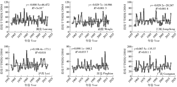
3.4 最长持续干旱时间笔者以日降水 < 1 mm为标准分别统计非岩溶区和岩溶石漠化区站点1959—2017年最长持续干旱时间(consecutive dry days, CDD)的变化趋势,结果如图 4,可见,非岩溶区澜沧、勐腊、江城站最长持续干旱时间的变化速率分别为0.000 5、0.029 7和0.029 2 d/a,而岩溶石漠化区泸西、屏边、广南则分别为0.106 4、0.098 1和0.087 5 d/a。
|
图 4 云南非岩溶区、岩溶石漠化区最长持续干旱时间变化趋势 Fig. 4 Trends of consecutive dry days (CDD) in non-karst area and karst rocky desertification area |
进行比较后可以看出,非岩溶区和岩溶石漠化区最长持续干旱时间都有增加的趋势,但岩溶石漠化区的平均增加幅度为0.097 d/a,较非岩溶区的0.030 d/a更大。采用Mann-Kendall检验分别对6个站点的变化趋势进行检验后发现,在所有站点中仅有石漠化区屏边站的增加幅度达到0.05的置信水平。
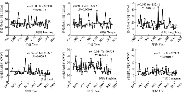
3.5 最长持续降水时间以日降水>1 mm为阈值,依次统计6个站点最长持续降水时间(consecutive wet days, CWD)的演变趋势,结果见图 5。从图 5中可以看出,非岩溶区澜沧、勐腊和江城站最长持续降水时间的变化速率分别为-0.008 8、0.004 9和-0.083 0 d/a,而岩溶石漠化区泸西、屏边和广南则分别为-0.033 6、-0.044 7和-0.012 8 d/a。
|
图 5 云南非岩溶区、岩溶石漠化区最长持续降水时间变化趋势 Fig. 5 Trends of consecutive wet days (CWD) in non-karst area and karst rocky desertification area |
可见,在全球气候变化背景下,除非岩溶区的勐腊站最长持续降水时间有微弱增加趋势外,其余站点均为减少趋势。然而,对6个站点的变化趋势进行显著检验后得知,虽然其变化都没有达到0.05的显著水平,但岩溶石漠化区的减少时间更大,均值为-0.031 d/a。
4 讨论 4.1 全球气候变化与降水变化降水与蒸发是控制陆地淡水资源的重要因子,1901—2005年全球总降水量没有显著的变化趋势,但区域降水量存在一定的变化趋势[1]。刘瑜等[20]采用云南124站点1961—2007年的数据计算发现,云南省降水量呈现减少趋势,速率为0.45 mm/a。对云南非岩溶区、岩溶石漠化区典型站点的对比分析中发现,非岩溶区、岩溶石漠化区降水都发生了变化,且岩溶石漠化区降水过程的平均变化速率-17.98%较非岩溶区的-11.34%更为凸显,表明这是全球气候变化的区域响应,但叠加石漠化因素后,降水变率更大。
4.2 岩溶石漠化与降水极值化全球气候变暖背景下降水变化的典型特征是极端化[1],云南省1959年以来极端强降水时间呈增多的趋势[18, 21-22]。本研究区受气候变化与岩溶石漠化的协同影响,强降水尤其是暴雨的平均倾向率达0.048%/a,最长持续干旱时间0.097 d/a,最长持续降水-0.031 d/a,极端化趋势较非岩溶区更为明显。结果符合预期,也为解释气候变化影响下我国西南岩溶山区灾害更为频繁提供直接证据[23]。
5 结论1) 除去非岩溶区勐腊站降水量有微弱增加趋势外,其余站点均呈现出减少趋势,岩溶石漠化区降水量的平均变化速率-17.98%较非岩溶区的-11.34%更大,减少趋势更为明显,其中泸西站降水量的变化趋势-2.844 3 mm/a达到显著水平。
2) 1959—2017年非岩溶区和岩溶石漠化区所有6个站点的降雨时间均呈现为减少趋势,岩溶石漠化区降雨时间的平均减少幅度-0.225 d/a较非岩溶区的-0.118 d/a更大,其中泸西的减少率-0.28 d/a达到0.05的置信水平。
3) 各降雨雨级中,中雨雨级所占比例在非岩溶区、岩溶石漠化区最高(均值34.04%)而暴雨(均值15.08%)最低,研究时段内强降水尤其是暴雨主要表现为增加趋势,岩溶石漠化区增加更为显著。
4) 岩溶石漠化区、非岩溶区2类区域的最长持续干旱时间都呈现出增加的趋势,但是岩溶石漠化区的增加幅度0.097 d/a较非岩溶区的0.030 d/a更大,其中石漠化区屏边站的增加速率0.098 d/a达到0.05的置信水平。
5) 剔除非岩溶区的勐腊站最长持续降水时间有微弱增加趋势(0.005 d/a)外,其余站点均为减少趋势,总体来看岩溶石漠化区减少的幅度更大(均值-0.031 d/a),但均未达到0.05的置信水平。
| [1] |
Intergovernmental Panel on Climate Change. Climate change 2014: Impacts, adaptation and vulnerability: Regional aspects[M]. Cambridge, UK: Cambridge University Press, 2014: 2.
|
| [2] |
李森, 魏兴琥, 张素红, 等. 典型岩溶山区土地石漠化过程: 以粤北岩溶山区为例[J]. 生态学报, 2010, 30(3): 674. LI Sen, WEI Xinghu, ZHANG Suhong, et al. The processes of land rocky desertification in typical Karst Mountain area: A case study in the karst mountain area of North Guangdong[J]. Acta Ecologica Sinica, 2010, 30(3): 674. |
| [3] |
朱大运, 熊康宁. 气候因子对我国喀斯特石漠化治理影响研究综述[J]. 江苏农业科学, 2018, 46(7): 16. ZHU Dayun, XIONG Kangning. A review of the impact of climate factors on karst rocky desertification control in China[J]. Jiangsu Agricultural Science, 2018, 46(7): 16. |
| [4] |
李生, 薛亮, 王佳, 等. 石漠化地区裸岩表面温度和空气温湿度动态变化[J]. 生态学杂志, 2019, 38(2): 436. LI Sheng, XUE Liang, WANG Jia, et al. The dynamics of bare rock surface temperature, air temperature and relative humidity in karst rocky desertification area[J]. Chinese Journal of Ecology, 2019, 38(2): 436. |
| [5] |
袁道先. 我国岩溶资源环境领域的创新问题[J]. 中国岩溶, 2015, 34(2): 98. YUAN Daoxian. Scientific innovation in karst resources and environment research field of China[J]. Carsologica Sinica, 2015, 34(2): 98. |
| [6] |
张信宝, 王世杰, 白晓永, 等. 贵州石漠化空间分布与喀斯特地貌、岩性、降水和人口密度的关系[J]. 地球与环境, 2013, 41(1): 1. ZHANG Xinbao, WANG Shijie, BAI Xiaoyong, et al. Relationship between spatial distribution of rocky desertification and karst landform, lithology, precipitation and population density[J]. Earth and Environment, 2013, 41(1): 1. |
| [7] |
谷晓平, 于飞, 刘云慧, 等. 降雨因子对喀斯特石漠化发生发展的影响研究[J]. 水土保持通报, 2011, 31(3): 66. GU Xiaoping, YU Fei, LIU Yunhui, et al. Study on the influence of rainfall factors on the occurrence and development of karst rocky desertification[J]. Bulletin of Soil and Water Conservation, 2011, 31(3): 66. |
| [8] |
张勇荣, 周忠发, 马士彬. 近20年贵州喀斯特山区石漠化与气候变化特征分析[J]. 环境科学与技术, 2014, 37(4): 192. ZHANG Yongrong, ZHOU Zhongfa, MA Shibin. Characteristics of rocky desertification and climate change in Guizhou Karst mountain area in recent 20 years[J]. Environmental Science and Technology, 2014, 37(4): 192. |
| [9] |
DENG Y H, WANG S J, BAI X Y, et al. Relationship among land surface temperature and LUCC, NDVI in typical karst area[J]. Scientific Reports, 2018, 8(1): 1. |
| [10] |
颜萍, 刘子琦, 肖杰, 等. 喀斯特石漠化治理区不同土地利用方式的小气候效应[J]. 中国岩溶, 2016a, 35(5): 557. YAN Ping, LIU Ziqi, XIAO Jie, et al. Microclimatic effects of different land use patterns in karst rocky desertification control area[J]. Carsologica Sinica, 2016a, 35(5): 557. |
| [11] |
吴克华, 熊康宁, 李坡. 不同等级石漠化综合治理的小气候效应: 以贵州省花江峡谷为例[J]. 地球与环境, 2009, 37(4): 411. WU Kehua, XIONG Kangning, LI Po. Microclimatic effects of comprehensive management of different levels of rocky desertification: A case study of Huajiang gorge in Guizhou province[J]. Earth and Environment, 2009, 37(4): 411. |
| [12] |
崔高仰, 熊康宁. 喀斯特地区不同程度石漠化综合治理的小气候效应[J]. 广东农业科学, 2015(1): 143. CUI Gaoyang, XIONG Kangning. Microclimate effects of comprehensive management of rocky desertification in different degrees in Karst area[J]. Guangdong Agricultural Science, 2015(1): 143. DOI:10.3969/j.issn.1004-874X.2015.01.032 |
| [13] |
熊华, 于飞. 喀斯特中度石漠化地区不同生境小气候变化特征[J]. 贵州农业科学, 2013, 41(8): 103. XIONG Hua, YU Fei. Characteristics of microclimate change in different habitats in moderate karst rocky desertification area[J]. Guizhou Agricultural Science, 2013, 41(8): 103. DOI:10.3969/j.issn.1001-3601.2013.08.027 |
| [14] |
符娇兰, 林祥, 钱维宏. 中国夏季分级雨日的时空特征[J]. 热带气象学报, 2008, 24(4): 367. FU Jiaolan, LIN Xiang, QIAN Weihong. The temporal and spatial characteristics of grader summer rain days over China[J]. Journal of Tropical Meteorology, 2008, 24(4): 367. DOI:10.3969/j.issn.1004-4965.2008.04.009 |
| [15] |
宁晓菊, 张丽君, 杨群涛, 等. 1951年以来中国无霜期的变化趋势[J]. 地理学报, 2015, 70(11): 1811. NING Xiaoju, ZHANG Lijun, YANG Quntao, et al. Trends in the frost-free period in China from 1951 to 2012[J]. Acta Geographica Sinica, 2015, 70(11): 1811. DOI:10.11821/dlxb201511010 |
| [16] |
MANN H B. Nonparametric test against trend[J]. Econometrica, 1945, 13(3): 245. DOI:10.2307/1907187 |
| [17] |
程建刚, 解明恩. 近50年云南区域气候变化特征分析[J]. 地理科学进展, 2008, 27(5): 19. CHENG Jiangang, XIE Mingen. The analysis of regional climate change features over Yunnan in recent 50 year's[J]. Progress in Geography, 2008, 27(5): 19. |
| [18] |
彭贵芬, 刘瑜. 云南各量级雨日的气候特征及变化[J]. 高原气象, 2009, 28(1): 214. PENG Guifeng, LIU Yu. Climatic characteristic and change of rain day for different intensities in Yunnan[J]. Plateau Meteorology, 2009, 28(1): 214. |
| [19] |
汪卫平, 杨修群, 张祖强, 等. 中国雨日数的气候特征及趋势变化[J]. 气象科学, 2017, 37(3): 317. WANG Weiping, YANG Xiuqun, ZHANG Zuqiang, et al. Climatic characteristics and trend change of rain days in China[J]. Journal of the Meteorological Sciences, 2017, 37(3): 317. |
| [20] |
刘瑜, 赵尔旭, 黄玮, 等. 云南近46年降水与气温变化趋势的特征分析[J]. 灾害学, 2010, 25(1): 39. LIU Yu, ZHAO Erxu, HUANG Wei, et al. Characteristic analysis of precipitation and temperature change trend in Yunnan in recent 46 years[J]. Journal of Catastropholgy, 2010, 25(1): 39. DOI:10.3969/j.issn.1000-811X.2010.01.009 |
| [21] |
FAN Hui, HU Jinming, HE Daming. Trends in precipitation over the low latitude highlands of Yunnan, China[J]. Journal of Geographical Sciences, 2013, 23(6): 1107. DOI:10.1007/s11442-013-1066-y |
| [22] |
符传博, 吴涧, 丹利. 近50年云南省雨日及降水量的气候变化[J]. 高原气象, 2011, 30(4): 1027. FU Chuanbo, WU Jian, DAN Li. Climatic changes of rainfall and rain days in Yunnan province[J]. Plateau Meteorology, 2011, 30(4): 1027. |
| [23] |
袁道先. 西南岩溶石山地区重大环境地质问题及对策研究[M]. 北京: 科学出版社, 2012: 81. YUAN Daoxian. Study on major environmental geological problems and countermeasures in Southwest karst mountain area[M]. Beijing: Science Press, 2012: 81. |
 2022, Vol. 20