2. 大连科技学院, 116052, 辽宁大连
-
项目名称
- 水利部公益性行业科研专项“东北灌区节水灌溉生态效益评估”(201401001)
-
第一作者简介
- 赵搏华(1995—),女,硕士研究生。主要研究方向: 水土保持与荒漠化防治。E-mail: boha@163.com
-
通信作者简介
- 王秀茹(1957—),女,博士,教授。主要研究方向:水土保持与荒漠化防治,流域管理。E-mail: wang-xr@163.com
-
文章历史
-
收稿日期:2020-11-02
修回日期:2021-10-18
2. 大连科技学院, 116052, 辽宁大连
2. Dalian Institute of Science and Technology, 116052, Dalian, Liaoning, China
水土保持监测的目的是为掌握生产建设项目建设过程中的水土流失程度、危害、发展规律及水土保持效果。近年来,无人机遥感影像进行自动分类技术越来越多地应用在水土保持监测领域,而主流的自动分类方法是面向对象分类法。不少学者们研究发现,该方法与遥感数据结合可以满足不同行业的测算需求。如王枚梅等[1]基于面向对象方法提取亚高山针叶林的参数,得到高效、可靠的无人机遥感影像分类结果。李梦华等[2]和唐磊[3]研究基于面向对象分类对梯田遥感影像自动提取,可以准确地获得梯田及空间分布等相关信息。还有学者基于厘米级无人机影像应用面向对象方法[4],对黑土区的垄台垄沟等线性水土保持措施进行自动识别,结果表明该方法基本可实现对黑土区水土保持措施的精准识别。同时也有学者对比不同的面向对象分类方法的应用,如毛双双[5]研究高峰林场面向对象分类后的变化检测,结果表明决策树分类法优于最邻近分类法,精度更高。邬亚娟等[6]研究Cart决策树、C4.5决策树、KNN、SVM 4种分类方法在干旱半干旱地区植被面向对象的分类精度,结果表明基于决策树的分类精度高于KNN、SVM算法。也有学者通过邻近、K-最邻近、决策树、支持向量机和随机森林5种方法提取冻土热融滑塌边界的性能和精度[7],得出SVM方法的Kappa系数高于其他4种分类方法,更适合无人机遥感影像冻土热融滑塌边界的提取。所以,研究不同面向对象分类方法的应用,对遥感影像分类具有重要意义。目前,面向对象分类法在水土保持措施中的应用主要集中在植被和梯田等,而在水土保持监测中措施的应用较少,且通过比较多种方法,探索不同分类方法在水土保持监测中措施分类效果的研究也较少。因此,笔者采用5种面向对象的分类方法对生产建设项目中水土保持措施参数提取,分析影像分类方法的精度,以期为高效率地开展水土保持监测提供参考依据,完善无人机在水土保持监测中的应用体系。
1 研究区概况2022年冬奥会延庆赛区雪车雪橇中心场地位于赛区核心区南区中部山脊之上,场地西侧紧邻西大庄科村,南侧邻改线后的松闫路,北靠山麓,东侧隔山谷是延庆冬奥村。项目主要建设内容包括场馆设施、配套设施、赛道工程等。占地总面积18.69 hm2。目前主体工程基本竣工。
延庆区的地势东高西低,中部凹陷形成山间盆地。区内山脉海拔700~1 000 m。项目地处延庆区西北部,北部邻海坨山主峰,最高海拔2 190 m,以中山峡谷地貌为主,属暖温带大陆性季风气候区。
2 材料与方法 2.1 无人机遥感影像数据笔者采用大疆精灵4无人机,搭载FC330镜头用来数据采集,影像分辨率为4 000×2 250,拍摄时间为2018年6月。航拍飞行高度为321 m,采用GPS/GLONASS双模卫星定位模块[8],航向重叠度和旁向重叠度均为80%,共获取正射影像125幅。采用光盘作为标记[9],在研究区内布设控制点和检查点。
2.2 影像数据初步处理研究主要采用Photoscan软件[10],经过初步处理、点云加密,后生成正射影像图,为导入eCognition软件进行处理提供数据支持。研究参与分类的波段有蓝波段、绿波段、红波段和近红外波段4种。
经过文献查阅和野外勘测,根据研究区的水土保持措施的种类和分布特点,将研究区划分为2个片区,第一片区分为5类: 植被、临时苫盖措施(裸土)、工程措施编织袋装表土和挡墙、裸地及其他。第二片区分为6类:植被、临时苫盖措施(裸土)、临时苫盖措施(植被)、工程措施排水沟和框格护坡、裸地及其他。
2.3 影像分割尺度本研究使用多尺度分割算法来实现影像分割。因为梁林林等[7]认为影像分割会对影像分类有一定的影响,故设置初始尺度为20,形状因子为0.1,紧致度因子为0.5,通过尺度优化工具ESP 2[11]进行初步尺度参数的选择。仍存在分割不到位的现象,后结合目视解译试验确定分割尺度分别为92和56时,水土保持措施真实性更强,措施边界更完整。
2.4 分类方法及参数选择笔者选择面向对象分类技术中常用的隶属度函数、最邻近、决策树、支持向量机、随机森林5种分类方法,并使用验证样本数据对分类结果进行评价。
参数选择方面,隶属度函数(membership function)分类需通过不断调整类别范围来确定某一地物的最优阈值范围,再判断该地类的适用变化曲线[12]为准确的阈值。
最邻近分类法(nearest neighbor, NN)是将每一个影像对象按照对应的对象特征寻找与其最邻近的样本匹配,最终完成分类的过程[13]。所以该方法需要在原始影像中为不同类型均匀地选择具有典型特征信息的样本。
Cart决策树(classification and regression tree)是由Breiman等提出的一种决策树构建方法[14],本文结合相关文献选用5作为第一片区depth值,0为第二片区depth值。
SVM分类法,综合考虑本研究的样本数量大小,采用线性核函数进行分类。C(惩罚系数)是对误差的宽容度,研究选择惩罚系数为2。
随机森林(random forest)分类方法由Breiman Leo与Adele Cutler于2001年提出的一种机器学习算法[15]。根据相关文献结合研究区内具体措施选择决策树的数量为1 000,分类特征总数为16。
根据提取的训练样本对象的光谱、纹理和空间特征指标[16]对样本进行精确选择。
2.5 精度评价方法采用总体精度、Kappa系数、生产者精度(Producer accuracy,PA),3个指标来定量评价5种分类方法的分类结果。其中,总体精度和Kappa系数(根据Kappa系数精度判别标准,0.6~0.8为分类精度较好,>0.8~1.0为分类精度极好)用于比较整体分类精度,生产者精度用于评价特定地类的分类精度[17]。
3 水土保持措施分类结果水土保持措施总体分类精度见表 1,在第一片区,水土保持措施较少,分布较集中时,SVM分类法效果最好,总体精度为86.13%。其他分类方法总体精度大小关系为:隶属度函数(85.64%)>最邻近分类法(85.43%)>Cart决策树(84.43%)>随机森林分类法(84.22%)。在第二片区,水土保持措施较多,分布交错时,SVM分类法效果也最好,其总体精度为62.34%。其他分类方法总体精度大小关系为:最邻近分类法(61.59%)>随机森林总体精度为(60.02%)>Cart决策树分类法(59.90%)>隶属度函数分类(58.84%)。从分类精度分析,第一片区高于第二片区,而两者的Kappa系数均>0.69,最高达到0.81。所以,5种方法在2个片区都得较好的分类效果。
| 表 1 各分类法的总体精度和Kappa系数对比 Tab. 1 Comparison of overall accuracy and Kappa coefficient of each classification method |
从表 2对各水土保持措施精度对比分析可知,2个片区的植被分类效果都很好,而SVM分类法比其他4种分类法精度更高,生产者精度分别为96.00%和93.25%。第一片区的临时苫盖措施(裸土)分类效果较好的也是SVM分类法,生产者精度为80.0%;而第二片区的临时苫盖措施(裸土)分类结果较好的是最邻近分类法,其生产者分类精度为73.94%。临时苫盖措施(植物)分类较好的是最邻近分类法,生产者分类精度为76.23%。工程措施中,编织袋装表土和排水沟分类精度较高的方法是SVM分类法,生产者精度分别为81.51%和70.34%;挡墙的5种分类方法分类效果差异较小,其中较高的生产者精度为71.42%;框格护坡分类精度较高的分类方法是最邻近分类法,生产者分类精度为66.37%。
| 表 2 各分类方法对水土保持措施的精度评价 Tab. 2 Accuracy evaluation of classification methods to soil and water conservation |
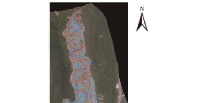
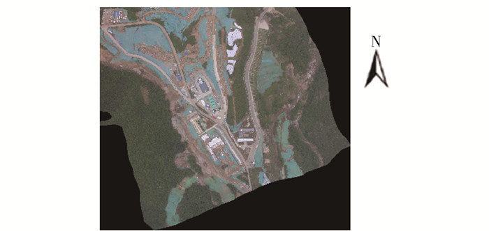
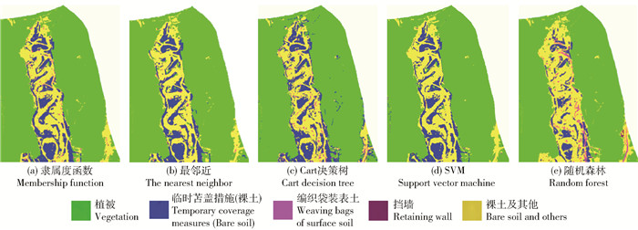
2个片区原始影像如图 1和图 2,5种分类方法分类结果如图 3和图 4所示。

|
图 1 第一片区原始影像 Fig. 1 Original image of the first area |

|
图 2 第二片区原始影像 Fig. 2 Original image of the second area |

|
图 3 第一片区分类方法分类结果图 Fig. 3 Classification result graphs by classification methods for the first area |

|
图 4 第二片区分类方法分类结果图 Fig. 4 Classification result graphs by classification methods for the second area |
第一片区的Kappa系数均在0.8左右,第二片区的Kappa系数均在0.7左右,5种方法的Kappa系数都>0.69,各方法都得到了较好的分类效果。其中,第一片区的总体精度均高于第二片区的总体精度。可能由于第一片区水土保持措施种类的光谱特征差异明显,且措施面积比例大,易提取。而第二片区的多种水土保持措施交错分布,且措施的特征信息差异较小,所以对分类精度有影响。其中,该片区的隶属度函数、Cart决策树和随机森林分类法分类效果较差。可能因为框格护坡与排水沟的光谱特征较为相似,不易区分。且隶属度函数的阈值范围难确定,工作量较大,耗时长。所以使用隶属度函数、Cart决策树和随机森林分类法方法时,较适用在措施种类少、措施光谱特征差异显著的研究区。
2个片区中植被的分类效果显著,生产者精度均>90%。其中精度较高的是SVM分类法,与林卉等[12]研究的植被分类结果相近。可能因为植被利用归一化植被指数和较多的样本数量,可以高效完成植被的分类。在水土保持措施分布较集中时,临时苫盖措施(裸土)运用SVM分类法分类的效果良好;在水土保持措施种类多样,分布错杂时,最邻近分类法的效果较好。临时苫盖措施(植物)里分类精度较高的方法是最邻近分类法。工程措施中编织袋装表土和排水沟分类时采用SVM分类法效果良好。框格护坡分类时最邻近分类法的精度较高。另外,挡墙的5种分类方法分类精度差异较小,建议分类时使用操作简便,速度更快的最邻近分类法。
综上,SVM分类法在2个片区的Kappa系数分别为0.81和0.72,均高于其他4种方法。所以SVM方法更适合该研究区水土保持措施的分类。
| [1] |
王枚梅, 林家元, 林沂, 等. 基于无人机可见光影像的亚高山针叶林树冠参数信息自动提取[J]. 林业资源管理, 2017(4): 82. WANG Meimei, LIN Jiayuan, LIN Yi, et al. Subalpine coniferous forest crown information automatic extraction based on optical UAV remote sensing imagery[J]. Forest Resources Management, 2017(4): 82. |
| [2] |
李梦华, 石云, 马永强, 等. 基于面向对象的黄土丘陵沟壑区梯田信息提取研究[J]. 测绘与空间地理信息, 2019, 42(5): 50. LI Menghua, SHI Yun, MA Yongqiang, et al. Terrace information extraction in loess hilly-gully region landscape based on object-oriented classification method[J]. Geomatics & Spatial Information Technology, 2019, 42(5): 50. DOI:10.3969/j.issn.1672-5867.2019.05.016 |
| [3] |
唐磊. 基于GF-2影像的黄土丘陵区梯田田坎自动提取研究[D]. 兰州: 甘肃农业大学, 2020: 32. TANG Lei. Research on automatic extraction of terraced ridges in loess hilly region based on GF-2[D]. Lanzhou: Gansu Agricultural University, 2020: 32. |
| [4] |
夏晨真, 张月. 基于厘米级无人机影像的水土保持措施精准识别[J]. 水土保持学报, 2020, 34(5): 111. XIA Chenzhen, ZHANG Yue. Accurate identification of soil and water conservation measures based on centimeter-resolution UAV images[J]. Journal of Soil and Water Conservation, 2020, 34(5): 111. |
| [5] |
毛双双. 基于高分一号面向对象分类后林地变化检测研究[D]. 南宁: 广西大学, 2018: 26. MAO Shuangshuang. Research on forest land change detection based on object oriented classification of G-F1[D]. Nanning: Guangxi University, 2018: 26. |
| [6] |
邬亚娟, 刘廷玺, 童新, 等. 基于面向对象的干旱半干旱地区植被分类[J]. 干旱区研究, 2020, 37(4): 1026. WU Yajuan, LIU Yanxi, TONG Xin, et al. Vegetation classification in arid and semi-arid areas using an object-oriented method[J]. Arid Zone Research, 2020, 37(4): 1026. |
| [7] |
梁林林, 江利明, 周志伟, 等. 无人机遥感影像面向对象分类的冻土热融滑塌边界提取[J]. 国土资源遥感, 2019, 31(2): 180. LIANG Linlin, JIANG Liming, ZHOU Zhiwei, et al. Object-oriented classification of unmanned aerial vehicle image for thermal erosion gully boundary extraction[J]. Remote Sensing for Land & Resources, 2019, 31(2): 180. |
| [8] |
周湘山, 秦甦, 魏凡, 等. 面向对象分类技术在开发建设项目水土保持监测中的应用[J]. 水土保持通报, 2018, 38(3): 130. ZHOU Xiangshan, QIN Su, WEI Fan, et al. Application of object-oriented classification technology in monitoring of soil and water conservation for development and construction projects[J]. Bulletin of Soil and Water Conservation, 2018, 38(3): 130. |
| [9] |
阎世煜, 王秀茹, 王霄, 等. 无人机遥感数据处理模型的计算精度分析——以引黄入冀补淀工程水土保持监测为例[J]. 中国水土保持科学, 2019, 17(2): 121. YAN Shiyu, WANG Xiuru, WANG Xiao, et al. Accuracy analysis of model processing UAV remote sensing data: A case study of soil and water conservation monitoring for the Yellow River to Baiyangdian Water Transfer Project[J]. Science of Soil and Water Conservation, 2019, 17(2): 121. |
| [10] |
巴明坤. 小型无人机在生产建设项目水土保持监测中的应用[D]. 陕西杨凌: 西北农林科技大学, 2019: 16. BA Mingkun. Application of small UAV in soil and water conservation monitoring of production and construction projects[D]. Yangling, Shaanxi: Northwest A&F University, 2019: 16. |
| [11] |
DRǍGUŢ L, TIEDE D, LEVICK S. ESP: A tool to estimate scale parameters for multiresolution image segmentation of remotely sensed data[J]. International Journal of Geographical Information Science, 2010, 24(6): 859. DOI:10.1080/13658810903174803 |
| [12] |
林卉, 邵聪颖, 李海涛, 等. 高分辨率遥感影像5种面向对象分类方法对比研究[J]. 测绘通报, 2017(11): 17. LIN Hui, SHAO Congying, LI Haitao, et al. Five object-oriented classification methods analysis based on high-resolution remote sensing image[J]. Bulletin of Surveying and Mapping, 2017(11): 17. |
| [13] |
孙燕霞. 基于高空间分辨率遥感影像的土地利用信息提取[D]. 重庆: 重庆交通大学, 2014: 20. SUN Yanxia. Land use information extraction based on remote sensing image of high spatial resolution[D]. Chongqing: Chongqing Jiaotong University, 2014: 20. |
| [14] |
BREIMAN L, FRIEDMAN J, OLSHEN R, et al. Classification and regression tree[M]. London: Chapman & Hall/CRC, 1984: 6.
|
| [15] |
BREIMAN L. Random forests[J]. Machine Learning, 2001, 45(1): 5. DOI:10.1023/A:1010933404324 |
| [16] |
陈蕊, 张继超. 基于eCognition的遥感图像面向对象分类方法研究[J]. 测绘与空间地理信息, 2020, 43(2): 91. CHEN Rui, ZHANG Jichao. Study on object-oriented classification method of remote sensing image based on eCognition[J]. Geomatics & Spatial Information Technology, 2020, 43(2): 91. |
| [17] |
宋宏利, 雷海梅, 霍志敏, 等. 基于Sentinel-2A的太行山区土地覆被分类方法研究[J]. 河北工程大学学报(自然科学版), 2020, 37(2): 100. SONG Hongli, LEI Haimei, HUO Zhimin, et al. Land use/cover classification in Taihang mountain area based on Sentinel-2A[J]. Imagery Journal of Hebei University of Engineering (Natural Science Edition), 2020, 37(2): 100. |
 2022, Vol. 20
