2. 西北农林科技大学 水土保持研究所 黄土高原土壤侵蚀与旱地农业国家重点实验室, 712100, 陕西杨凌;
3. 中国科学院 水利部 水土保持研究所, 712100, 陕西杨凌
中国水土保持科学  2021, Vol. 19 2021, Vol. 19  Issue (1): 52-59. DOI: 10.16843/j.sswc.2021.01.007 Issue (1): 52-59. DOI: 10.16843/j.sswc.2021.01.007 |
砒砂岩广泛分布于黄土高原北部,它是由厚层砂岩、砂页岩和泥质砂岩组成的岩石互层;由于其成岩程度低,砂粒间胶结程度差,结构强度低,故而遇水状如泥土,干燥时则坚硬如石。晋陕蒙接壤地区土壤类型以风沙土和黄绵土为主,根据砒砂岩上层土壤类型的不同,可以将砒砂岩区分为覆沙区、覆土区和裸露区3个亚区[1]。该区的土壤结构以及保水保肥性能差,极易发生水土流失,多年平均土壤侵蚀模数为3万t/(km2·a),0.05 mm粒径以上的粗沙占80%,是黄河粗沙的主要来源区之一[2-3]。20世纪90年代以来,随着退耕还林(草)工程的施行,该区域大面积营造人工林,植被覆盖度逐渐提升,生态环境得到改善[4-5]。土壤水分是干旱区生态环境恢复的主要限制因子[6-7],水量平衡过程中输入项与输出项的动态变化及各种水源之间的相互转化能够决定其含量的多少[8]。土壤水分对该区的植被生长、水分循环和生态恢复等有重要影响。
由于成土因素的差异以及人为因素的影响,土壤水分的空间分布表现出不同程度的变异性,并且这种变异性是尺度的函数[9]。在不同尺度(例如田间、坡面、流域、区域等)上,土壤水分的变异性有所不同。当前,对土壤水分空间分布特征的研究很多。丁聪等[10]研究黄土高寒区人工林恢复坡面0~200 cm深土壤水分的空间变化特征,发现在测定时间段内,剖面各土层土壤含水率无显著差别,在空间上表现为中等变异性,且呈现随土层深度增加逐渐增大的趋势。安彬[11]研究秦岭中山区典型坡面不同用地类型的土壤水分,结果表明,不同土地利用类型土壤水分均值表现出一致性,且各层多表现出中等程度变异性,坡位、有机质等对坡面土壤水分影响显著。张晨成等[12]选取黄土高原水蚀风蚀交错区六道沟小流域的2个典型切沟样点作研究对象,分析了土壤水分的时空变化特征,发现土壤储水量与距沟道距离有关,植被特征影响土壤水分在垂直方向上的变化,沟道影响较小,坡位能够影响坡面土壤储水量的空间分布格局。胡伟等[13]对黄土高原退耕坡地土壤水分空间变异特征进行研究,结果表明土壤水分沿坡长方向表现为从坡顶到坡脚先减小后增大的趋势,变异程度为坡上>坡中>坡下。上述研究多集中在土壤质地较为均一的区域,砒砂岩区由于上覆土层的差异,形成了层状的土岩结构,同一坡面不同坡位土层厚度也存在差异,这种分层结构对土壤水分分布的影响尚不明确。在坡面植被重建过程中,土壤水分作为限制因素,应充分考虑坡位对土壤含水量空间分布的影响。
因此,笔者以砒砂岩典型坡面土壤水分为研究对象,通过分析不同深度以及不同坡位土壤水分空间分布特征,以期为砒砂岩区植被恢复过程中植被配置提供数据支撑和科学依据。
1 研究区概况研究区位于内蒙古自治区准格尔旗圪秋沟流域内(E 110°25′~110°48′,N 39°42′~39°50′),平均海拔820~1 582 m,总面积约为96 km2。该流域内千沟万壑,地形起伏大,土壤侵蚀程度强,水土流失非常严重。研究区属于典型的中温带半干旱大陆性季风气候,年均降水量约400 mm,年均蒸发量约2 093 mm,年平均气温为6.2~8.7 ℃。该地区四季分明,太阳辐射强烈,日照时间长,平均日照时间2 900~3 100 h。春季风力大、持续时间较长,年平均风速3.2 m/s,最大风速32 m/s,年平均大风时间10~30 d。
研究区土壤类型主要是黄绵土和风沙土,主要草本植物有羊草(Leymus chinensis)、本氏针茅(Stipa capillata)、沙蒿(Artemisia ordosica)。该区植被以人工植被为主,造林树种主要为沙棘(Hippophae rhamnoides)、油松(Pinus tabuliformis)、锦鸡儿(Caragana korshinskii)和山杏(Prunus sibirica)等[2]。
2 研究方法 2.1 取样方法自退耕还林(草)工程实施以来,鱼鳞坑整地是该区域常见的造林整地方式。笔者选择长度约为200 m,宽度约为40 m,植被恢复类型为油松的完整坡面作为研究区域,其中油松种植在鱼鳞坑内。沿坡顶至坡下均匀布设38个采样点,编号如图 1所示。将1-A至4-C 12个样点作为坡下代表样点,5-A至8-C 12个样点作为坡中代表性样点,9-A至13-B 14个样点作为坡上代表性样点。于2019年7月29日至8月2日完成1-A至5-C样点的采样工作,于8月21日至9月2日完成其余样点的采样工作,8月2日至8月21日期间有降雨发生。在每一样点,用土钻(直径5 cm)分层采集土壤样品,其中0~20 cm每10 cm采集1个土样,20 cm以下每20 cm分层取样。受坚硬砒砂岩层的影响,采样深度最浅到达2 m,最深达到6 m,共采集土壤样品862份。当天采样后,采用烘干法(105 ℃,12 h)测定土壤质量含水量。

|
图 1 砒砂岩典型坡面样点分布图 Fig. 1 Distribution map of sampling sites on a typical slope in the feldspathic sandstone area |
利用Excel 2016和SPSS 23进行各变量的描述性统计、单因素方差分析(ANOVA)及数据的正态性检验;利用Origin 2019、SigmaPlot 12.5进行绘图;采用GS+确定各层土壤水分数据符合的最优理论模型及其参数;利用Arcmap10.2对样点土壤水分分布进行地统计学分析并绘图。地统计学的相关理论及相关参数的含义详见参考文献[14-16]。
3 结果与分析 3.1 坡面土壤水分变化特征 3.1.1 样点土壤水分随深度变化特征表 1为油松人工林坡面0~200 cm深剖面土壤含水量的基本统计特征值。整个坡面平均含水量为12.03%,变异系数为33.08%。根据Nielsen等[17]的划分,当变异系数>100%时,为强变异;介于10%~100%之间时,为中等变异;<10%时,为弱变异;因此,笔者研究中坡面土壤水分为中等程度变异。土壤含水量在不同深度的变化范围为3.21%~27.51%,均值的变化范围为9.93%~13.83%,变异系数介于18.68%~39.80%之间,均为中等程度变异性。表层土壤平均含水量最低,仅为9.93%,随着深度的增加,平均含水量呈现增加的趋势,180~200 cm土层平均含水量最高,达到13.88%。单因素方差分析结果表明,0~120 cm各层土壤含水量均值差异不显著(P>0.05),10~140 cm土层土壤含水量差异也不显著(P>0.05),140 cm深度以下土壤含水量呈微弱增加趋势,而表层0~20 cm土壤含水量显著低于140~200 cm土壤含水量(P<0.05)。各层土壤平均含水量与变异系数之间呈负极显著相关关系(P<0.01)。每层数据经过K-S检验结果显示都符合正态分布。
| 表 1 油松人工林坡面0~200 cm剖面土壤水分统计特征值 Tab. 1 Statistical characteristic of soil moisture along the 0-200 cm profile of the slope with Pinus tabuliformis plantation |
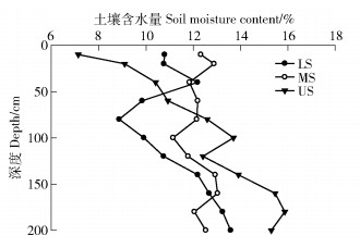
图 2显示了不同坡位土壤水分随深度的变化趋势。浅层0~40 cm土壤含水量坡中和坡下大于坡上(P<0.05),且0~20 cm坡中土壤含水量大于坡下(P>0.05);40~160 cm土壤含水量坡上和坡中大于坡下(P>0.05),除60 cm以外,坡上的土壤含水量大于坡中;160~180 cm土壤含水量坡上最大,坡下次之,坡中最小。此外,在同一坡位,坡下土壤水分呈波动状,随着深度的增加,土壤水分先增加而又下降,在80 cm处达到最小值后开始逐渐上升;坡中的土壤含水量在0~200 cm整体上变化不大,比较稳定;而坡上的土壤含水量呈逐渐上升趋势,在60 cm深度以下坡上的土壤含水量是整个坡面上最高的。

|
US、MS、LS分别表示坡上、坡中、坡下。 US, MS and LS refers to the up, middle and low slope, respectively). 图 2 不同坡位土壤水分随深度变化趋势 Fig. 2 Change of soil moisture in different slope positions with different depths |
利用地统计方法对坡面0~200 cm深度土壤水分的空间结构及其自相关性进行分析。表 2为各土层土壤含水量半方差函数最优模型及其相关参数,根据决定系数最大和残差平方和最小的原则确定最优模型。除40~80 cm土层以外,其他各层决定系数均>0.456。高斯模型能够拟合大部分土层土壤水分的空间结构,其次是球状模型。各土层的块金值都不为0,表明存在采样误差和小于采样尺度的变异[15]。空间异质比可以体现随机变异占总变异的大小,该值越小,表明变量的空间结构性越强。除60~80 cm土层土壤含水量为弱空间依赖性以外,其他各层土壤含水量均为强空间依赖性[16]。
| 表 2 各土层土壤水分半变异函数的参数 Tab. 2 Semi-variogram parameters for soil moistures in various soil depths |
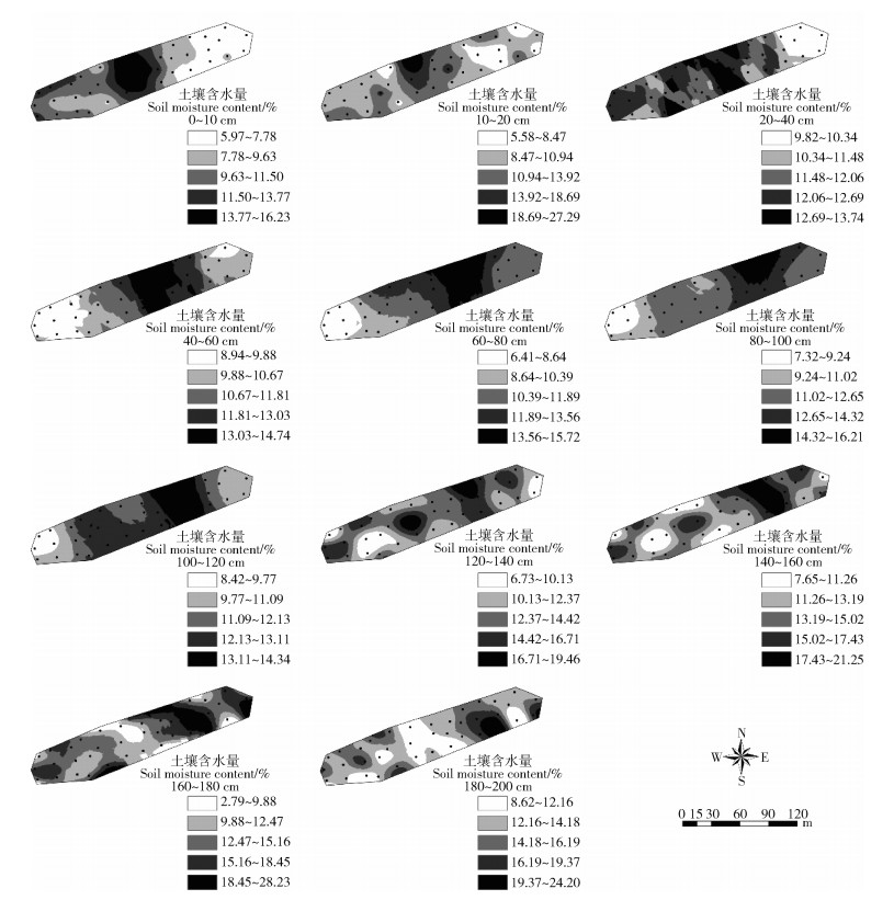
无论采样点密度多大,传统的野外采样和室内测定的手段无法得到所有区域的土壤水分值,而空间插值技术则可以将离散的数据转化为连续的空间曲面进而实现土壤水分数据全覆盖[10]。利用普通克里格插值绘制坡面0~200 cm各层土壤含水量的空间分布图(图 3),可以直观地反映各土层土壤含水量的变异性及空间分布特征。可见,各土层土壤含水量大多呈斑块状镶嵌分布,尤其是0~20 cm以及120~200 cm各土层更为明显。

|
图 3 坡面土壤水分空间分布趋势图 Fig. 3 Maps for the spatial distribution of soil moisture in slopes |
土壤水分受土壤质地、地形因子、植被耗水、降雨入渗、土壤蒸散、干湿季节交替和人类活动等因素的影响,因此具有高度的异质性[18]。砒砂岩区位于半干旱区,年均蒸发量远大于年均降雨量。采样过程中发现,随着深度的增加,砒砂岩开始出现,未风化的砒砂岩比较致密,具有较强的持水能力[19]。土壤质地、蒸发以及植被蒸腾的共同作用导致浅层土壤含水量低于深层(表 1)[20]。浅层土壤含水量的变异系数比深层土壤大,这是因为在采样期间存在降雨。此外,土壤的蒸发以及植物的蒸腾作用都会对浅层土壤含水量产生影响,从而产生较大的变异[9]。坡面大量存在的鱼鳞坑也会增加浅层土壤含水量的变异性[11]。Penna等[21]研究意大利阿尔比斯山坡面表层土壤水分时空异质性,发现土壤含水量与土壤水分变异性呈反比,这与本研究结果一致。对不同坡位土壤含水量的分析得出,0~40 cm土层坡中和坡下的土壤含水量大于坡上(P<0.05)(图 2),表明土壤含水量受坡位影响。徐学选等[22]以及安彬[11]研究发现,坡位是影响地块尺度和坡面尺度土壤含水量空间分布的主要因子。下坡位更易于获取水分的补充,但是由于下坡位植被生长茂密,消耗水分更多,使得坡上和坡下土壤含水量没有明显差别,这也说明土壤水分受多个因素的共同影响。
变程(a)表示的是半方差达到基台值时的测点间距,可以在一定程度上反映空间变量的最大自相关距离,为确定合理的取样尺度提供依据[23]。不同拟合模型的最大自相关距离与变程的关系不一致,线性模型和球状模型的最大自相关距离等于a,高斯模型的最大自相关距离为3a,而指数模型的最大自相关距离为3a[24-25]。由表 2可知,各层土壤含水量的变程介于15.60~91.07 m之间,大于我们的最小采样间距(15 m),表明样点分布足以代表整个坡面的土壤含水量的空间变异结构特征[26]。
5 结论1) 砒砂岩区典型坡面土壤水分的变异特征具有深度依赖性。各层土壤水分均为中等程度变异,随着土层深度的增加,土壤含水量逐渐升高,而变异系数整体呈现下降趋势。
2) 砒砂岩区典型坡面不同深度土壤水分的差异与坡位有关。浅层(0~40 cm)土壤水分坡中和坡下高于坡上,坡中和坡下更有利于植被恢复。
3) 0~200 cm各土层土壤含水量的变程介于15.60~91.07 m之间,可以为该区后续土壤水分空间分布特征研究的样点布设提供参考依据。
| [1] |
王愿昌, 吴永红, 寇权, 等. 砒砂岩分布范围界定与类型区划分[J]. 中国水土保持科学, 2007, 5(1): 14. WANG Yuanchang, WU Yonghong, KOU Quan, et al. Definition of arsenic rock zone borderline and its classification[J]. Science of Soil and Water Conservation, 2007, 5(1): 14. |
| [2] |
尉迟文思, 姚云峰, 郭月峰, 等. 砒砂岩地区3种主要树种边材液流动态特征[J]. 水土保持学报, 2017, 31(5): 203. YUCHI Wensi, YAO Yunfeng, GUO Yuefeng, et al. Dynamic variation of sapwood flow of three main tree species in a soft sand-rock area[J]. Journal of Soil and Water Conservation, 2017, 31(5): 203. |
| [3] |
伍艳, 杨忠芳, 刘慧, 等. 砒砂岩物质组成及其对养分含量的影响[J]. 人民黄河, 2016, 38(6): 18. WU Yan, YANG Zhongfang, LIU Hui, et al. Critical quantify of W-OH soil stabilizer to control soil erosion in Pisha sandstone region[J]. Yellow River, 2016, 38(6): 18. |
| [4] |
杨振奇, 秦富仓, 李晓琴, 等. 砒砂岩区主要造林树种枯落物及林下土壤持水特性[J]. 水土保持学报, 2017, 31(3): 118. YANG Zhenqi, QIN Fucang, LI Xiaoqin, et al. Water-holding characteristics of litters and soil under major afforestation tree species in the feldspathic sandstone region[J]. Journal of Soil and Water Conservation, 2017, 31(3): 118. |
| [5] |
黎铭, 张会兰, 孟铖铖, 等. 皇甫川流域2000-2015年植被NDVI时空变化特征[J]. 林业科学, 2019, 55(8): 36. LI Ming, ZHANG Huilan, MENG Chengcheng, et al. Spatial-temporal variations of vegetation coverage in Huangfuchuan basin from 2000 to 2015[J]. Scientia Silvae Sinicae, 2019, 55(8): 36. |
| [6] |
王云强, 邵明安, 胡伟, 等. 黄土高原关键带土壤水分空间分异特征[J]. 地球与环境, 2016, 44(4): 391. WANG Yunqiang, SHAO Ming'an, HU Wei, et al. Spatial variations of soil water content in the critical zone of the Chinese Loess Plateau[J]. Earth and Environment, 2016, 44(4): 391. |
| [7] |
LIANG Haibin, XUE Yayong, LI Zongshan, et al. Soil moisture decline following the plantation of Robinia pseudoacacia forests: Evidence from the Loess Plateau[J]. Forest Ecology and Management, 2018, 412: 62. DOI:10.1016/j.foreco.2018.01.041 |
| [8] |
徐学选, 张北赢, 田均良. 黄土丘陵区降水-土壤水-地下水转化实验研究[J]. 水科学进展, 2010, 21(1): 16. XU Xuexuan, ZHANG Beiying, TIAN Junliang. Experimental study on the precipitation-soil water-ground water transformation in loess hilly region[J]. Advances in Water Science, 2010, 21(1): 16. |
| [9] |
王云强, 邵明安, 刘志鹏. 黄土高原区域尺度土壤水分空间变异性[J]. 水科学进展, 2012, 23(3): 310. WANG Yunqiang, SHAO Ming'an, LIU Zhipeng. Spatial variability of soil moisture at a regional scale in the Loess Plateau[J]. Advances in Water Science, 2012, 23(3): 310. |
| [10] |
丁聪, 王冬梅, 贺康宁, 等. 黄土高寒区坡面土壤水分的时间稳定性研究[J]. 生态学报, 2020, 40(1): 1. DING Cong, WANG Dongmei, HE Kangning, et al. Study of temporal stability of soil moisture on hillslope in loess regions of China[J]. Acta Ecologica Sinica, 2020, 40(1): 1. |
| [11] |
安彬. 陕南旬阳坝地区坡面土壤水分影响因子研究[J]. 山西农业科学, 2017, 45(7): 1128. AN Bin. Study on soil moisture contributing factors of Xunyangba area in southern Shaanxi province[J]. Journal of Shanxi Agricultural Sciences, 2017, 45(7): 1128. |
| [12] |
张晨成, 邵明安, 王云强, 等. 黄土区切沟对不同植被下土壤水分时空变异的影响[J]. 水科学进展, 2016, 27(5): 679. ZHANG Chencheng, SHAO Ming'an, WANG Yunqiang, et al. Effects of gullies on the spatiotemporal variability of soil-water under different vegetation types on the Loess Plateau[J]. Advances in Water Science, 2016, 27(5): 679. |
| [13] |
胡伟, 邵明安, 王全九. 黄土高原退耕坡地土壤水分空间变异性研究[J]. 水科学进展, 2006, 17(1): 74. HU Wei, SHAO Ming'an, WANG Quanjiu. Study on spatial variability of soil moisture on the recultivated slope-land on the Loess Plateau[J]. Advances in Water Science, 2006, 17(1): 74. |
| [14] |
QIAO Jiangbo, ZHU Yuanjun, JIA Xiaoxu, et al. Spatial variation and simulation of the bulk density in a deep profile (0-204 m) on the Loess Plateau, China[J]. Catena, 2018(164): 88. |
| [15] |
WANG Jinman, YANG Ruixuan, BAI Zhongke. Spatial variability and sampling optimization of soil organic carbon and total nitrogen for Minesoils of the Loess Plateau using geostatistics[J]. Ecological Engineering, 2015, 82: 159. DOI:10.1016/j.ecoleng.2015.04.103 |
| [16] |
CAMBARDELLA C A, MOORMAN T B, PARKIN T B, et al. Field-scale variability of soil properties in central Iowa soils[J]. Soil Science Society of America Journal, 1994, 58(5): 1501. DOI:10.2136/sssaj1994.03615995005800050033x |
| [17] |
NIELSEN D R, BOUM J. Soil spatial variability[M]. Las Vegas, USA, 1985: 2.
|
| [18] |
孔凌霄, 毕华兴, 周巧稚, 等. 晋西黄土区不同立地刺槐林土壤水分动态特征[J]. 水土保持学报, 2018, 32(5): 163. KONG Lingxiao, BI Huaxing, ZHOU Qiaozhi, et al. Dynamics of soil moisture in different stand sites of Robinia Pseudoacacia forestlands in loess region of western Shanxi province[J]. Journal of Soil and Water Conservation, 2018, 32(5): 163. |
| [19] |
SUN Zenghui, HAN Jichang. Effect of soft rock amendment on soil hydraulic parameters and crop performance in Mu Us Sandy Land, China[J]. Field Crops Research, 2018, 222: 85. DOI:10.1016/j.fcr.2018.03.016 |
| [20] |
佘冬立, 邵明安, 俞双恩. 黄土区农草混合利用坡面土壤水分空间变异性[J]. 农业机械学报, 2010, 41(7): 57. SHE Dongli, SHAO Ming'an, YU Shuang'en. Spatial variability of soil water content on a cropland-grassland mixed slopeland in the Loess Plateau, China[J]. Transactions of the CSAM, 2010, 41(7): 57. |
| [21] |
PENNA D, BROCCA L, BORGA M, et al. Soil moisture temporal stability at different depths on two alpine hillslopes during wet and dry periods[J]. Journal of Hydrology, 2013, 477: 55. DOI:10.1016/j.jhydrol.2012.10.052 |
| [22] |
徐学选, 刘文兆, 高鹏, 等. 黄土丘陵区土壤水分空间分布差异性探讨[J]. 生态环境, 2003, 12(1): 52. XU Xuexuan, LIU Wenzhao, GAO Peng, et al. The discussion on soil moisture distributional diversity in hilly Loess Plateau region[J]. Ecology and Environment, 2003, 12(1): 52. |
| [23] |
刘春利, 胡伟, 贾宏福, 等. 黄土高原水蚀风蚀交错区坡地土壤剖面饱和导水率空间异质性[J]. 生态学报, 2012, 32(4): 207. LIU Chunli, HU Wei, JIA Hongfu, et al. Spatial heterogeneity of soil saturated hydraulic conductivity on a slope of the wind-water erosion crisscross region on the Loess Plateau[J]. Acta Ecologica Sinica, 2012, 32(4): 207. |
| [24] |
索立柱. 黄土高原不同空间尺度土壤水分动态变化影响因素分析与随机模拟[D]. 陕西杨凌: 西北农林科技大学, 2019: 1. SUO Lizhu. Analyses and stochastic modelling of soil moisture dynamics at different spatial scales on the Loess Plateau[D]. Yangling, Shaanxi: Northwest A&F University, 2019: 1. |
| [25] |
潘成忠, 上官周平. 黄土半干旱丘陵区陡坡地土壤水分空间变异性研究[J]. 农业工程学报, 2003, 19(6): 5. PAN Chengzhong, SHANGGUAN Zhouping. Spatial variability of soil moisture on steep slopeland in loess hill region[J]. Transactions of the CSAE, 2003, 19(6): 5. |
| [26] |
LI Xiangdong, SHAO Ming'an, ZHAO Chunlei, et al. Spatial variability of soil water content and related factors across the Hexi Corridor of China[J]. Journal of Arid Land, 2019, 11(1): 123. DOI:10.1007/s40333-018-0123-x |