-
项目名称
- 国家自然科学基金重点项目"西南黄壤区不同尺度土壤侵蚀与泥沙运移规律耦合关系"(41730748);贵州省水利科技经费项目"生物炭在喀斯特黄壤坡耕地保护性耕作中的应用研究"(KT201617)
-
第一作者简介
- 杨志成(1993-), 男, 硕士研究生。主要研究方向:土壤资源利用与保护。E-mail:zyang@mail.bnu.edu.cn
-
通信作者简介
- 张科利(1962-), 男, 教授, 博士生导师。主要研究方向:土壤侵蚀。E-mail:keli@mail.bnu.edu.cn
-
文章历史
-
收稿日期:2019-02-28
修回日期:2019-07-25
土壤侵蚀是人类社会面对的最严重的环境和公共健康问题之一[1]。我国的土壤侵蚀问题尤为严重,《第一次全国水利普查水土保持情况公报》显示,2011年全国水土流失总面积达294.91万km2[2]。由于地处喀斯特的核心地带,土层浅薄、成土速度慢,贵州省成为我国土壤侵蚀和生态环境问题最严重的地区之一[3-4]。
地形是影响土壤侵蚀的重要因子,在USLE(universal soil loss equation)等模型中,坡度和坡长因子是计算土壤侵蚀模数的重要参数。关于坡度和坡长对土壤侵蚀的影响,黄土高原和红壤区的研究结果均表明,侵蚀量随坡度和坡长的增大而增加[5-6]。但在贵州喀斯特地区,土壤侵蚀模数随着坡度的增加表现出先增加后减少再增加的趋势[7-8],而土壤侵蚀模数随着坡长的增加而增加[7, 9-10]。由于贵州喀斯特地貌广泛发育,地形破碎,区域差异显著,基于坡面和小流域尺度的研究结果尚不能够全面反映出全省区域尺度的土壤侵蚀状况,坡面、单个小流域的水土流失研究也难以适应大面积开发治理的实际需求[11]。另外,零散的贵州省域土壤侵蚀研究均未考虑省内地貌分区,研究结果在省内各区域的适用性有待考察。笔者利用第一次全国水利普查资料,以调查单元和耕地地块为基础,利用空间插值方法,同时结合地貌类型分区,从全省区域尺度定量研究贵州省坡耕地土壤侵蚀状况,为该地区水土保持规划布局和确定生态恢复治理重点区域提供理论依据。
1 研究区概况贵州省位于我国亚热带地区,土地面积约17.6万km2。地势西高东低,自中部向北、东、南三面倾斜。平均海拔在1100m左右,最高海拔为2900.6m。境内高原山地居多,平原较少。年均降水量大于1100mm,次降雨强度大,历时短,主要集中在4—9月。土壤类型主要为黄壤。人地矛盾突出,水土流失问题严重。
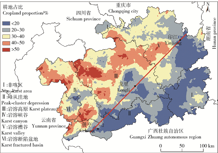
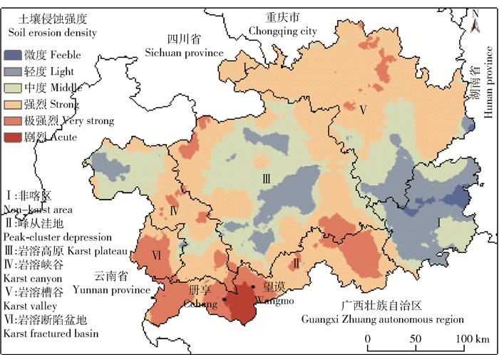
2 材料与方法第一次全国水利普查水土保持专项调查采用抽样调查方法,在贵州省布设调查单元1306个,耕地地块共4533个,调查内容包括降雨、土壤、地形、植被覆盖、生物、工程和耕作措施等计算土壤侵蚀模数所需的相关参数。数据信息精准详细,可以反映区域的实际情况,为定量研究大尺度土壤侵蚀特征及现状提供了数据基础。使用SPSS 19.0软件进行数据统计分析,土壤侵蚀模数根据CSLE(Chinese soil loss equation)模型计算得到,各侵蚀因子的信息和计算方法参见文献[12]。在土壤侵蚀量计算过程中,根据课题组以往研究结果[13]对耕作措施因子进行修正。从吴协保等[14]和王世杰等[15]研究中可知,贵州省地貌分为热带喀斯特区(峰丛洼地、岩溶高原、岩溶盆地、岩溶峡谷、岩溶断陷盆地)以及非热带喀斯特区(简称非喀区)。利用ArcGIS 10.2软件提取地貌类型分区数据,并叠加地貌类型分区绘制专题图(图 1和图 2)。

|
图 1 贵州省地貌分区及耕地占比空间分布 Fig. 1 Regional divisions of geomorphy and spatial distribution of cropland proportion in Guizhou province |

|
图 2 贵州省耕地土壤侵蚀强度空间分布 Fig. 2 Spatial distribution of cropland soil erosion intensity in Guizhou province |
如图 1所示,贵州省的耕地占比空间分布差异明显,大致从西向东递减,并以印江、龙里、册亨一线为界,分界线以东耕地占比几乎都在40%以下,以西耕地占比多在40%以上。峰丛洼地和非喀区分别有51.98%和61.63%的区域耕地占比小于20%。耕地占比大于40%的区域以岩溶高原所占比例最高,占该地貌分区面积的43.79%。
3.2 耕地分布的地形条件分析总的来看,全省91.28%的耕地坡度分布在8°~35°之间(表 1)。岩溶槽谷有超过1/2的坡耕地坡度集中在15°~25°,高于其他分区;峰丛洼地大于25°的陡坡耕地占比最多,占该区坡耕地的22.72%,高于其他分区;岩溶断陷盆地15°以下的缓坡耕地比例最高,占全区耕地的41.75%。不同地貌分区之间的耕地坡长没有明显差异(表 2),坡长 < 25m的耕地占比都在 < 5%,均有超过1/2的耕地坡长>45m,其中45~55m坡长的耕地在各区占比均最大,占各地貌分区耕地的30.87%~39.51%。
|
表 1 各地貌类型分区不同坡度下耕地平均占比
Tab. 1 Average cropland proportion of different slope gradient in regional divisions by geomorphy |
|
表 2 各地貌类型分区不同坡长下耕地平均占比
Tab. 2 Average cropland proportion of different slope length in regional divisions by geomorphy |
由图 2和表 3可知,不同地貌分区之间耕地侵蚀强度差异明显。非喀区耕地侵蚀强度均在剧烈以下,并且以轻度和微度侵蚀为主,两者占非喀区耕地的79.92%。岩溶高原有将近60%的耕地未达到中度侵蚀强度;岩溶峡谷和岩溶断陷盆地耕地侵蚀模数多在30~200t/km2之间。峰丛洼地侵蚀最严重,达到剧烈侵蚀强度的耕地高于其他分区,占全区的34.97%,主要分布在的册亨和望谟两县;另外岩溶断陷盆地区侵蚀较强烈,>30%的耕地属于极强烈侵蚀。
|
表 3 各地貌类型分区不同耕地土壤侵蚀强度面积所占比例
Tab. 3 Area proportion of different cropland soil erosion intensity in regional divisions by geomorphy |
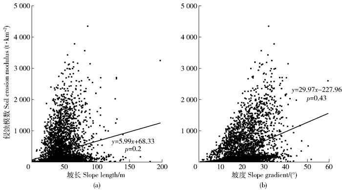
由表 4可知,各地貌分区的耕地侵蚀模数整体随着坡度的增加而增加,但耕地侵蚀模数随坡长的增加未表现出明显的变化趋势。对侵蚀模数和坡长、坡度进行相关性分析可知(图 3),侵蚀模数与坡长的相关性(P=0.20)明显小于侵蚀模数与坡度的相关性(P=0.43),说明坡度对土壤侵蚀的影响大于坡长对土壤侵蚀的影响。
|
表 4 各地貌类型分区不同坡长坡度下耕地平均侵蚀模数
Tab. 4 Cropland average soil erosion modulus of different slope length and gradient in different regional divisions by the geomorphy |

|
图 3 坡长(a)、坡度(b)与耕地土壤侵蚀模数的关系 Fig. 3 Relationship between topographical factors and cropland soil erosion modulus, (a) for slope length and (b) for slope gradient. |
根据监测数据和实验结果[16-17]显示,坡度主要通过影响径流流速、土壤入渗和土体稳定性等因素影响坡面土壤侵蚀。随着坡度的增加,坡面径流流速增大,入渗速率减少,侵蚀能力增强,同时土体稳定性降低,抗侵蚀阻力减弱,综合作用下,导致随坡度增大,土壤侵蚀加重。在全省范围内,耕地侵蚀模数随着坡度的增加而增加,与水土流失监测和实验结果相接近。监测小区以及模拟实验所选坡度多在25°以下,而贵州省有83.74%的耕地 < 25°,所以普查结果和监测数据以及实验结果随坡度具有相同的变化趋势。而土壤侵蚀模数随着坡长变化与监测数据和模拟实验结果相差较大。可能是因为监测小区和模拟实验选择的坡长多集中在 < 25m,而普查资料显示贵州省耕地坡长多在25m以上分布,加之坡长对土壤侵蚀的影响比较复杂[9, 17],所以监测数据和实验结果并不能完全揭示贵州省耕地侵蚀随坡长变化的实际规律。另外,喀斯特耕地坡面不均一也可能导致耕地土壤侵蚀模数随坡长的增加未表现出明显的变化趋势。
贵州省耕地占比最高的区域在岩溶高原,而耕地土壤侵蚀最严重的区域在峰丛洼地,二者在空间上不匹配。这主要是由于岩溶高原耕地以缓坡为主,坡度多在15°以下,而峰丛洼地陡坡耕地占比高,有61.46%的耕地坡度>15°。峰丛洼地坡度较陡,径流产生的侵蚀动能较大,对土壤的侵蚀作用也较为突出[18-19],故而导致峰丛洼地耕地土壤侵蚀较岩溶高原更严重;另外,峰丛洼地区域内的册亨和望谟两县地势较高,水系发达,也是造成该分区内土壤侵蚀比较严重的原因之一。与喀斯特地区相比,非喀区耕地土壤侵蚀模数较小,大多在30t/km2以下。可能是由于非喀区耕地占比多在30%以下,受人类活动影响较小。同时非喀区林、草地占比大,植被覆盖度高,可以有效防止雨滴直接打击地表,减弱雨滴溅蚀,减缓径流流速。另外良好的植物根系在改良土壤性质、减少侵蚀方面也有着突出作用[20-21]。
5 结论1) 贵州省的耕地占比空间格局分布明显,以印江、龙里、册亨一线为界,西多东少。非喀区和峰丛洼地的耕地占比最低;岩溶高原西部耕地占比最高,多在50%以上。
2) 随着坡度的增加,耕地土壤侵蚀模数表现相应的增加的趋势,在喀斯特区域表现的尤为明显;随坡长的增加,耕地土壤侵蚀模数并未表现出明显的变化趋势。坡度比坡长对土壤侵蚀的影响显著。
3) 贵州省71.17%的耕地侵蚀侵蚀模数低于200t/km2。非喀区74.88%的耕地侵蚀强度在微度以下,所占比例最高;峰丛洼地区和岩溶断陷盆地区耕地侵蚀最为严重,剧烈侵蚀面积占比分别为34.97%和15.16%。因此,贵州省水土保持和生态治理重点区域应该在峰丛洼地,其次是岩溶断陷盆地。
| [1] |
PIMENTEL D. Soil Erosion:A food and environmental threat[J]. Environment, Development and Sustainability, 2006, 8(1): 119. |
| [2] |
中华人民共和国水利部. 第一次全国水利普查水土保持情况公报[J]. 中国水土保持, 2013(10): 58. Ministry of Water Resource of the People's Republic of China. The first national water conservancy survey of water and soil conservation bulletin[J]. Soil and Water Conservation in China, 2013(10): 58. |
| [3] |
王恒松, 熊康宁, 张芳美. 地形因子对喀斯特坡面水土流失影响的机理研究[J]. 水土保持通报, 2015, 35(4): 2. WANG Hengsong, XIONG Kangning, ZHANG Fangmei, et al. Mechanism study on effect of terrain on soil erosion of Karst slope[J]. Bulletin of Soil and Water Conservation, 2015, 35(4): 2. |
| [4] |
陈美淇, 魏欣, 张科利, 等. 基于CSLE模型的贵州省水土流失规律分析[J]. 水土保持学报, 2017, 31(3): 16. CHEN Meiqi, WEI Xin, ZHANG Keli, et al. Analysis of the characteristics of soil and water loss in Guizhou province based in CSLE[J]. Journal of Soil and Water Conservation, 2017, 31(3): 16. |
| [5] |
SHEN Haiou, ZHENG Fenli, WEN Leilei, et al. Impacts of rainfall intensity and slope gradient on rill erosion processes at loessial hillslope[J]. Soil and Tillage Research, 2016(155): 436. |
| [6] |
付兴涛, 张丽萍. 红壤丘陵区坡长对作物覆盖坡耕地土壤侵蚀的影响[J]. 农业工程学报, 2014, 30(5): 94. FU Xingtao, ZHANG Liping. Impact of slope length on soil erosion of sloping farmland with crop in red soil hilly region[J]. Transactions of the CSAE, 2014, 30(5): 94. |
| [7] |
ZHANG Xingqi, HU Maochuan, GUO Xinya. Effects of topographic factors on runoff and soil loss in Southwest China[J]. Catena, 2018(160): 398. |
| [8] |
张兴奇, 顾礼彬, 张科利, 等. 坡度对黔西北地区坡面产流产沙的影响[J]. 水土保持学报, 2015, 29(4): 19. ZHANG Xingqi, GU Libin, ZHANG Keli, et al. Impacts of slope gradient on runoff and sediment in Northwest Guizhou[J]. Journal of Soil and Water Conservation, 2015, 29(4): 19. |
| [9] |
蔡强国. 坡长对坡耕地侵蚀产沙过程的影响[J]. 云南地理环境研究, 1998, 10(1): 36. CAI Qiangguo. Soil erosion processes influenced by slope length on slopeland[J]. Yunnan Geographic Environment Research, 1998, 10(1): 36. |
| [10] |
高儒学, 高华端, 宋江平, 等. 坡长对贵州喀斯特区黄壤坡耕地土壤侵蚀的影响[J]. 水土保持研究, 2018, 25(2): 55. GAO Ruxue, GAO Huaduan, SONG Jiangping, et al. Influence of slope length on soil erosion in yellow sloping farmland of Karst[J]. Research of Soil and Water Conservation, 2018, 25(2): 55. |
| [11] |
熊康宁, 胡顺光. 贵州喀斯特地区水土流失研究进展[J]. 贵州师范大学学报(自然科学版), 2011, 29(4): 109. XIONG Kangning, HU Shunguang. Evolution of soil and water loss in Guizhou Karst area[J]. Journal of Guizhou Normal University (Natural Sciences), 2011, 29(4): 109. |
| [12] |
刘宝元, 郭索彦, 李智广, 等. 中国水力侵蚀抽样调查[J]. 中国水土保持, 2013, 34(10): 29. LIU Baoyuan, GUO Suoyan, LI Zhiguang, et al. Sampling program of water erosion inventory of China[J]. Soil and Water Conservation in China, 2013, 34(10): 29. |
| [13] |
郭继成, 顾再柯, 苑爽, 等. 西南喀斯特地区水土保持措施因子值计算与评价[J]. 中国水土保持, 2014(10): 50. GUO Jicheng, GU Zaike, YUAN Shuang, et al. Calculation and evaluation of factor value of water and soil conservation measures of Southwest Karst region[J]. Soil and Water Conservation in China, 2014(10): 50. |
| [14] |
吴协保, 孙继霖, 林琼, 等. 我国西南岩溶石漠化土地生态建设分区治理思路与途径探讨[J]. 中国岩溶, 2009, 28(4): 392. WU Xiebao, SUN Jilin, LIN Qiong, et al. Research on division treatment to eco-construction of karst rock deserted land in southwest China karst area[J]. Carsologica Sinica, 2009, 28(4): 392. |
| [15] |
王世杰, 张信宝, 白晓永. 中国南方喀斯特地貌分区纲要[J]. 山地学报, 2015, 33(6): 646. WANG Shijie, ZHANG Xinbao, BAI Xiaoyong. An outline of Karst geomorphology zoning in the Karst areas of Southern China[J]. Mountain Research, 2015, 33(6): 646. |
| [16] |
蒋荣.地形因子对贵州喀斯特地区坡面土壤侵蚀的影响[D].南京: 南京大学, 2013: 29. JIANG Rong. Impacts of topographic factors on soil erosion of slope land in karst areas in Guizhou province[D]. Nanjing: Nanjing University, 2013: 29. |
| [17] |
王占礼, 王亚云, 黄新会, 等. 黄土裸坡土壤侵蚀过程研究[J]. 水土保持研究, 2004, 11(4): 86. WANG Zhanli, WANG Yayun, HUANG Xinhui, et al. Soil erosion process research of the loess bare slope[J]. Research of Soil and Water Conservation, 2004, 11(4): 86. |
| [18] |
LIU Quan, ZHU Bo, TANG Jialiang, et al. Hydrological processes and sediment yields from hillslope croplands of regosol under different slope gradients at loessial hillslope[J]. Soil Science Society of America Journal, 2017, 81(6): 1523. |
| [19] |
WU Lei, PENG Mengling, QIAO Shanshan, et al. Effects of rainfall intensity and slope gradient on runoff and sediment yield characteristics of bare loess soil[J]. Environmental Science and Pollution Research, 2018, 25(4): 3483. |
| [20] |
MOHAMMAD A G, MOHAMMADA A. The impact of vegetative cover type on runoff and soil erosion under different land uses[J]. Catena, 2010, 81(2): 102. |
| [21] |
WEI Wei, CHEN Liding, FU Bojie, et al. Water erosion response to rainfall and land use in different drought-level years in a loess hilly area of China[J]. Catena, 2010, 81(1): 29. |
 2020, Vol. 18
