 2014, Vol. 28
The Chinese Meteorological Society
Article Information
- LI Ping-Wah, WONG Wai-Kin, CHEUNG Ping, YEUNG Hon-Yin. 2014.
- An Overview of Nowcasting Development, Applications, and Services in the Hong Kong Observatory
- J. Meteor. Res., 28(5): 859-876
- http://dx.doi.org/10.1007/s13351-014-4048-9
Article History
- Received May 7, 2014;
- in final form July 30, 2014


Nowcasting by definition is a collection of veryshort-range forecasting from zero up to a few hoursahead that starts from a "detailed description of thecurrent weather", and is made possible by fully utilizing all observations available, in particular remotesensing data from radar, satellite, lightning, GPS, wind profiler, etc. (e. g. Browning, 1982; Conway, 1998). This is the forecast range when forecasters and frontline staff often have to make critical operationaldecisions in the face of rapidly developing weather situations. Due to the high spatial and temporal resolution and update frequency of the advanced meteorological instruments, nowcasting can provide a verydetailed and informative four-dimensional descriptionof the current state as well as a short-term evolutionof the atmosphere. Nowcasting capability has therefore become a vital and specialized subject that affectsdaily forecasting operations as well as decision-makingprocesses in weather services(Liljas, 1998). Nowcasting also supplements the gap in numerical weather prediction where the latter has lower skill in the first fewhours of the model run when its performance has notyet stabilized.
The first international symposium dedicated tonowcasting was held in Hamburg, Germany, in 1981as part of the International Association of Meteorology and Atmospheric Physics Third Scientific Assembly(European Space Agency, 1981). The major topics discussed in the symposium were observations and very-short-range forecasts up to 2 h ahead. The second symposium of the same series was held in Norbert, Norway, in 1984. Lam(1984)presented a paper on using digital radar to study the evolution of rainstorm toprovide short-term forecast of rainfall over the HongKong territory. In his paper, he employed nowcasting technique to predict the surface rainfall up to 3 hahead for rain-bearing systems such as tropical cyclone and monsoon trough based on manual extrapolation ofradar echoes shown on radar screen. Though the performance was not very satisfactory at that time, Lam'sground work in fact laid down the foundation of nowcasting research and development of the Hong KongObservatory(HKO)in the following decades.
Affected by a couple of heavy rainstorms whichbrought significant flooding to Hong Kong, the HKOdecided to implement a Rainstorm Warning Systemin 1992 to warn the public of intense rainstorm. TheRainstorm Warning System operated at that time hadvery limited prediction power as warnings were issued mainly based on actual rainfall amount recorded. However, there were great dem and s from the publicfor a warning system that was based on forecast. Tomeet the dem and s of the public, HKO went forwardto develop an automatic system which could quantitatively forecast the amount of precipitation over theterritory. Then, the HKO's nowcasting research and development began to enter its rapid development era. 1. 2 The first generation nowcasting system-SWIRLS
The Rainstorm Warning System was enhanced in1998 to bring in the forecast element. The new system was operated based on the recorded or predictedrainfall amounts to issue either Amber, Red, or BlackRainstorm Warning(respectively representing morethan 30-, 50-, and 70-mm h-1 rainfall that would affectsignificant parts of the territory)to warm the public ofvarious severity of the rainstorm. To achieve that, theobservatory developed the first generation nowcastingsystem, named SWIRLS(Short-range Warning of Intense Rainstorms in Localized Systems), in 1996 and put the system in operation in 1998. SWIRLS consistsof:(1)simple automatic tracking of radar echoes bythe technique Tracking Radar Echoes by Correlation(TREC), (2)dynamical correlation of radar Z-R relation, (3)extrapolation of the existing radar echoesby simple advection scheme, and (4)audio-visual situational display for alarming the potential of Amber, Red, and Black Rainstorm Warnings. Though the system design was relatively simple, it turned out to berather useful for forecasters' reference under rainstormsituations(Lai and Li, 1999).
Borrowing the success story, SWIRLS in 2001 wassubsequently enhanced for issuance of other rainfall related warning services, namely, the L and slip Warning and Special Announcement on Flooding in the northern New Territories, in cooperation with the Civil Engineering Department and Drainage Department ofthe Hong Kong Special Administrative Region, respectively. Meanwhile, there were also dem and s on extending the forecast range from 1-2 h to a longer leadtime. To achieve that, the HKO also developed themesoscale numerical weather prediction(NWP)modelcalled the Non-Hydrostatic Model(NHM)adaptedfrom the Japan Meteorological Agency(JMA)(Saito et al. 2006)for the prediction of rainstorms in 6-12 hahead. On top of the direct model output, the modelgrids were phase-shifted by using pattern matchingskill based on actual radar echo images to adjustthe position of the forecast rainfall field. Meanwhile, SWIRLS was also enhanced with improved advectionscheme borrowed from the global models, namely, thesemi-Lagrangian advection(SLA)scheme, and successfully extended the extrapolation advection time upto 6 h ahead. The primary advantage of SLA is thatany flows especially those with curving features couldbe maintained in long run while the simple advectionscheme cannot maintain the curving structure of theforecast field soon after the forecast is started. Byincorporating the enhanced SWIRLS and the phase-adjusted NHM rainfall field, an extrapolation-model-blended system, namely, Rainstorm Analysis and Prediction Integrated Data-processing System(RAPIDS), was put into operational trial in 2005. It was one ofthe blended nowcasting systems put in real-time operation in the world by that time. 1. 3 SWIRL-II
To meet dem and s for alerting hazards associatedwith severe storms, SWIRLS was further enhancedwith the capability of predicting lightning, hail, squallthreats as well as probability of heavy precipitation. The first three capabilities were developed as additional modules based on object-based nowcasting techniques. The enhanced system, named SWIRLS-II, participated in the WMO/WWRP Forecast Demon-stration Project(FDP)held in the Beijing OlympicGames in 2008(B08) and Shanghai Expo in 2010(Cheng et al. 2011; WMO, 2012). During the FDPs, SWIRLS-II was demonstrated to be one of the bestperformed nowcasting systems in the world(WMO, 2009; Wilson et al. 2010).
SWIRLS II also contains a new module for predicting the probability of heavy precipitation by employing the time-lagged ensemble technique for theNHM. The two components were combined into onegraphical situational display named SWIRLS Panelfor Integrated Display of Alerts on Severe Storms(SPIDASS). SPIDASS was put into operation in2008. There were two more occasions where SWIRLS "participated" in, namely, the Commonwealth Gamesheld in India in 2010(Srivastava et al. 2012) and theUniversiade held in Shenzhen, China in 2011. Duringthose events, the HKO provided the SWIRLS softwarerespectively to Indian Meteorological Department and Shenzhen Meteorological Bureau with the software implemented and executed by the local personnel. HKOprovided training and overseas instructions for the implementation and execution of the software.
In the following paragraphs, we will highlight themajor technology of the various nowcasting systems and the respective services. We will also mentionabout the ongoing development of the HKO's now-casting research and services towards the end of thispaper. 2. Nowcasting technology
SWIRLS is a radar-based rainstorm nowcastingsystem which consists of three major components:(1)automatic tracking of radar echoes, (2)dynamical correlation of Z-R relation, and (3)extrapolation of theradar echoes(Li et al. 2000; Li and Lai, 2004a, b). 2. 1 Automatic radar echo tracking
In generic terms, automatic radar echo trackingmethods can be classified into:(a)differential tracking, (b)integral tracking, and (c)object-based tracking:
 |
| Fig. 1. (a)Schematic diagram about the algorithm of TREC, (b)sample TREC wind field of a thunderstorm, and (c)sample TREC wind field of a tropical cyclone. |
(a)Differential tracking. Tracking Radar Echoesby Correlation(TREC)belongs to this type(Rinehart, 1979)(Figs. 1a-c). The essence of this methodis to divide the whole radar image into a number ofboxes based on some pre-defined box size(representingthe spatial scale) and search the neighbouring boxesto determine the most similar box via maximizing thecorrelation R:
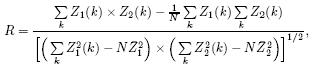
where Z1(k) and Z2(k)are respectively the radar re-flectivity at pixel k at two consecutive radar scan, e. g. in 6-min separation. Though simple, this method hasmany merits including: capable of capturing small-scale movement, capable of capturing divergence and circulation motion, and flexible in capturing variousscales by choosing different box sizes in the correlation exercise. The major disadvantage lies in the factthat this approach could easily miss out the large-scalemovement of the whole system.
(b)Integral tracking. Two algorithms calledMOVA(Multiscale Optical flow by Variational Analysis)(Wong et al. 2009) and ROVER(Real-time Optical flow by Variational method for Echoes of Radar)(Cheung and Yeung, 2012)developed in the HKO belong to this type. In essence, both methods employoptical flow technique(Aubert et al. 1999)that attempt to retrieve echo motion(u, v)from successiveradar images by minimizing the cost function:
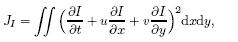
where I is the radar reflectivity at location(x, y) and t applies to two or three adjacent time levels(6 minin our case to align with the radar volume scanningscheme). To improve the quality of the motion vector, a constraint term Js is used to attain the smoothnessof the vector field via minimizing the square norm ofthe divergence of the resulting vector field, namely,
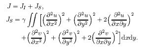
The dimensionless coe±cient fl, in the order of10-1, is to control effect of the smoothness term inthe minimization process. In MOVA, the cost function is applied 7 times to various scales(resolution)of the radar images to capture the motion fields. Thefinal motion field is obtained by adding all the motion fields on various subscales, with some predeter-mined weighting factors obtained through experience. The merits of MOVA/ROVER are that the motions ofvarious scales can be treated in one go and they cancapture better the system scale motion in comparisonwith the differential tracking method(Figs. 2a and 2b). ROVER has several enhancements over MOVAin terms of robustness against noise as inherited fromthe local features, and allowing tunable parameters toobtain better tracking results in squall lines and tropical cyclones. The major limitation of these methodslies on the fact that the tunable parameters which connect different scale motions are empirical, requiring alarge amount of historical cases to be optimized forrobustness in operational use.
 |
| Fig. 2. (a)Individual cell moving towards northeast by TREC and (b)large-scale motion moving towards southeastby MOVA. |
(c)Object-based tracking. This method groupsthe radar reflectivity image above pre-defined thresh-old into simple geometrical objects(circle, ellipse, polygon, etc. ) and track their respective movement viavarious matching methods(Dixon, 1995). In SWIRLS, there is a component named GTrack(Li and Lai, 2004a)which identifies congregated radar pixels oversome pre-defined intensity values and encircles the pixels by using ellipses(Figs. 3a and 3b). Once the ellipses(or cells)are identified, a number of cell parameters are calculated, including the arithmetic and weighted mean positions, average cell intensity, maximum intensity, 90th percentile intensity, and the derived geometric parameters such as the length and inclination angle of the major and minor axes. Tracking of the parent and daughter cells are achieved bysearching all possible cell positions in the previous image within a maximum allowable range and identifying the nearest cell with similar cell parameters, i. e. minimum change of the above cell parameters in time. From that, we can determine the so called GTrackvector, which represents the displacement of the centroid of the associated ellipse between successive images. Short-term forecast of the cell's future positionis then made by linear extrapolating the current cellby moving along the respective GTrack vector. Whentwo smaller cells are identified within the pre-definedsearching radius from a cell with nearly the combinedsize of the two cells at the previous step, they may betreated as the merger. In reverse, if a large cell fallswithin the searching radii of two smaller cells at thepresent time, they may be treated as splitter. In thesplitter case, only the most similar cell will be associated with its parent cell and tracked along their respective GTrack vector. The major merits of this methodinclude: capable of capturing well the movement ofthe whole system, and easily tracing the evolution ofthe objects identified. The well-known disadvantagesare: it cannot maintain the structure of any circulating/rotating motion including tropical cyclone ormeso-cyclone and it cannot h and le merging and splitting of the objects, hence limiting its forecasting capability to very short time. The severe weather module ofSWIRLS-II(Figs. 6a and 6b)was built mainly basedon the object-based tracking approach.
 |
| Fig. 3. (a)GTrack uses ellipses to identify and track the movement of the radar echo "objects" and (b)the current(solid line) and predicted(dashed line)positions of the radar echo "objects. " |
The extrapolation method adopted in SWIRLS isthe semi-Lagrangian advection(SLA)scheme. It isthe Robert's type of three iteration scheme used inmost of the global NWP models(Robert, 1982). InSWIRLS implementation, bi-cubic interpolation and flux limiter are used. The advantages of this schemeinclude: numerical stability and non-dispersive. Experience also demonstrates that it can retain the rotationfeature of motion field up to several hours ahead whilemost of the simple advection schemes do not possessthis desirable feature(Figs. 4a and 4b). This feature allows one to perform extrapolation up to severalhours ahead.
 |
| Fig. 4. (a)An ideal circulation pattern preserves after 6-h forecast time by using SLA and (b)6-h rainfall forecast ofa storm case by using SLA. |
This module is relatively straight forward but utmost crucial for obtaining accurate quantitative nowcast. Through minimizing the discrepancy betweenthe real-time surface raingauge data with the radarCAPPI reflectivity aloft(say at 2-km altitude), theparameters a and b in the radar-rainfall Z = aRb relation can be calibrated in real time. This is particularly useful for capturing the development of a rainstorm during its different evolution stages. The dynamically adjusted Z-R relation can also reflect therainfall accumulation of storms moving at differentspeeds. Through the updated Z-R relation, the extrapolated radar reflectivity field would be translatedinto the surface rainfall to provide realistic quantitative precipitation forecast. 2. 4 Severe weather nowcasting modules
To enhance SWIRLS's capability for nowcastingsevere weather associated with thunderstorms, several new features were implemented in SWIRLS-II. SWIRLS-II tracks and predicts severe weather objects that may lead to cloud-to-ground(CG)lightning, damaging thunderstorm squalls, and hail(Yeung et al. 2009). The following paragraphs will focus on theidentification and nowcasting of these three kinds ofthreats.
(a)Lightning nowcast
SWIRLS-II makes use of conceptual models tohelp select the critical precursors to identify severeweather. For CG lightning, SWIRLS-II employs theconceptual model so-called DELITE(Detection ofcloud Electrification and Lightning based on Isothermal Thunderstorm Echoes)(Yeung et al. 2007)algo-rithm to select parameters most relevant to the micro-physical processes leading up to the electrification ofa cumulus cloud as shown in Fig. 5a. In DELITE, the main source of electric charges is assumed to belocated in the mixed-phase layer between 0 and -20in a cumulus cloud. Prior to electrification, the up-draft is expected to separate the charge carriers ver-tically according to their weights. Being heavier, thenegative charge carriers(i. e. graupels)are expectedto reside mainly in the mixed-phase layer. The up-draft is also expected to pump super-cooled rain water into this layer and wet the carriers. The resultingradar echoes detectable in this layer therefore providean important clue.
 |
| Fig. 5. (a)DELITE's conceptual model of an electrifying cumulus cloud and (b)flow chart of the DELITE algorithm. |
To retrieve radar reflectivity at constant temperature levels, the thermal profile of the troposphere mustbe known in near real time. In DELITE, such information comes from either numerical weather model analysis or the latest available radiosonde data. Besidesisothermal reflectivity, the storm height and the totalamount of rain water in a cloud column are also identified as favourable factors. While the former is taken asa proxy for updraft strength, the latter indicates theavailability of hydrometeor to form charge carriers and release latent heat. The other radar predictors used inDELITE include echo top height, vertically integratedliquid(VIL), and 0, -10, and -20 isothermal reflectivities. Nowcasting of CG lightning initiation willbe triggered if these five radar parameters simultaneously exceed their prescribed thresholds, which may bedetermined by optimizing either the prediction skill orlead time of alerts by using historical thunderstormcases. In-cloud or cloud-to-cloud(CC)lightning observation is taken as an independent precursor to CGlightning initiation. The logical flow of the DELITEalgorithm is summarized in Fig. 5b.
(b)Nowcasting of downburst and squalls
Nowcasting of downburst and squalls in SWIRLSis based on the BLAAST(Buoyancy contribution and Loading effect of rain water to Air parcel Accelerationin Squally Thunderstorms; Yeung et al. 2008)algorithm that was developed with reference to the following conceptual model. The descending force thatcreates a thunderstorm downburst is attributed to thenet effect of buoyancy and water loading on an airparcel. In BLAAST, the former is calculated from radiosonde data as the downdraft convective potentialavailable energy which is estimated from radar VIL. When the parcel is dry, rain drops falling through itsvolume will evaporate, cool, and reduce its buoyancy. A downburst is considered triggered if the resultantforce acting on the air parcel is pointing downward. The maximum wind inducible on the ground is estimated by converting all the potential energy(due tobuoyancy and water loading combined) and initial kinetic energy(associated with the horizontal motion)ofthe descending parcel into wind energy at the groundlevel. The originating level of a downburst is assumedto be the wet-bulb freezing level and the maximumamount of the buoyancy energy convertible into windenergy is treated as a tunable parameter determinedby optimizing the prediction skill.
The above severe weather analyses are object oriented. The threat areas are first identified as elliptical cells in the corresponding interest fields with values greater than or equal to some prescribed thresh-olds. The detailed cell identification technique followsthe GTrack algorithm of SWIRLS. For lightning and downburst, the interest fields are 3-km CAPPI and 0-5-km VIL, respectively. The prescribed thresholdsadopted by SWIRLS are 25 dBZ and 5 mm, respectively. After identification, the DELITE and BLASSTalgorithms are applied accordingly to analyze if thecorresponding weather alerts have to be triggered.
(c)SWIRLS-II products suite
For severe thunderstorms, the major results arevisualized as an image product called the SevereWeather Map. Figure 6a shows an example issuedin real time for a squall line that traversed Hong Kongon 5 March 2009. On the map, textual alerts withquantitative details were printed at the bottom, asthe threat areas were intersecting or expected to intersect the warning zone(the red rectangle in Fig. 6a)for Hong Kong. SWIRLS-II outputs its products onthe map through its client workstation installed in theforecasting o±ce, as well as a web page named SPI-DASS(SWIRLS Panel for Integrated Display of Alertson Severe Storms)dedicated for severe weather alerts. As shown in Fig. 6b, the main panel of SPIDASS provides a compact view of all alerts arranged in rows and colour-coded for different severity levels. Embedded on these colour codes are hyperlinks to the corresponding Severe Weather Maps and rainfall maps.
 |
| Fig. 6. (a)Severe Weather Map of SWIRLS issued at 0306 HKT(Hong Kong Time)5 March 2009. Red and greyellipses indicate the analyzed threat areas of severe wind gust and CG lightning respectively. Dashed ellipses indicate theforecast positions of the threat areas at 30 min. Small yellow "o", black "=", and black "+" symbols mark the locationsof actual cloud-to-cloud, negative CG, and positive CG lightning, respectively. (b)Screen shot of SPIDASS on 4 June2009. Lightning and severe squall alerts are shown respectively on the second and third rows from the bottom(upperrows refer to rainstorm related alerts). |
Owing to its intrinsic limitation, linear extrapolation along the TREC wind can only provide reliableforecast up to 1-2 h ahead, for persisting thunder-storms. In order to extend the forecast range and tocapture the development and dissipation of thunder-storms, an extrapolation-model-blending approach isadopted to enhance SWIRLS. In this approach, radarlinear extrapolation products are blended dynamicallywith outputs from a high horizontal resolution(5 km)NWP model, namely, the RAPIDS(Li et al. 2005; Wong et al. 2009). Volume radar reflectivity data areingested into NHM via the LAPS data analysis system(Albers et al. 1996)to improve the model initialmoisture field. Recently, Doppler radar radial wind and three-dimensional(3D)radar wind are also ingested in the 3DVAR data assimilation system(Wong et al. 2011)for improving the model initial condition(see Section 4).
The algorithm in the SWIRLS-NHM consists ofthe following procedures:(1)obtain SWIRLS radarreflectivity, and convert it into surface precipitationusing dynamic reflectivity-rainfall(Z-R)relation; (2)obtain precipitation forecast from the NHM; and (3)perform the blending process(Fig. 7). The wholeblending involves sophisticated procedures, which canbe described as follows:
 |
| Fig. 7. Schematic diagram showing the components ofthe SWIRLS-NWP blending approach. |
(1)Phase correction. To tackle the problem ofspatiotemporal errors in the model precipitation forecast, phase correction is applied to the direct modeloutput. Location departure in the forecast precipitation patterns from NHM is estimated with respectto the actual radar-rainfall distribution(i. e. radarestimated rainfall calibrated against rain gauges). Variational technique is adopted, which minimizes theroot mean square error of the forecast rainfall fieldfrom a previous model run(usually initialized at 1-2 h before) and the actual precipitation distribution(Wong et al. 2009). When there is large differencebetween the model QPF and actual precipitation distribution, the variational method would fail to converge. Under this situation, no phase correction willapply to the QPF and the algorithm will continue withprocedure(2)below.
(2)Calibration of the intensity of model QPF. The intensity of model precipitation is corrected according to the radar-based quantitative precipitationestimate(QPE).
(3)Blending of calibrated model QPF with theradar nowcasting, with larger weighting assigned tothe nowcasting component at short lead times and increasing weighting to the NWP component as leadtime increases to 6 h.
The blended forecast precipitation is then converted back to forecast radar reflectivity at the gridpoints, based on the dynamic Z-R conversion formula. Figure 8 shows the comparison between SWIRLS simple extrapolation(1-6-h forecasts) and the SWIRLS-NHM blended forecasts for the case of 4 June 2009(1-6-h forecasts). The right panels of the figure areradar-based QPE at the respective forecast hours. Itappears that the rainfall forecasts produced by simple extrapolation overestimate the rainfall beyond 2h. The blended approach, however, produces forecastprecipitation field resembling that based on the radarechoes. This example demonstrates that the SWIRLS-NHM blending system could produce more reasonableforecasts, making it a feasible approach to extend theskill of the thunderstorm nowcasting beyond the firstcouple of hours.
 |
| Fig. 8. An example showing the comparison between the e®ects of SWIRLS simple extrapolation and blending ofSWIRLS and NHM rainfall forecast. Figures from top to bottom are 1-, 2-, . . . 6-h simple extrapolation(left column) and the blended precipitation(middle column)forecasts. Figures on the right show the corresponding radar-based QPE(on di®erent scales). |
Figure 9 shows some verification skill scores, namely, Probability of Detection(POD) and Critical Success Index(CSI)of the gridded QPF from theROVER optical flow(red), TREC(blue), SWIRLS-NHM blended nowcast(green), and direct RAPIDS-NHM outputs(orange)during the rainy season frommid March to July 2014. In general, the optical flowmethod can give a higher skill than TREC. The blending of nowcast(using QPF based on ROVER tracking)with the high-resolution RAPIDS-NHM improves theskill further throughout the 6-h lead time.
 |
| Fig. 9. (a)POD and (b)CSI of grid-based verification ofQPF from ROVER tracking(red), TREC(blue), blendedforecast(green), and RAPIDS-NHM(orange). |
SWIRLS and SWIRLS-II were mainly designedfor providing rainstorm-related nowcasting and warnings for the general public. SWIRLS was also adaptedto provide services for specialized users. The first specialized user was the aviation community. At the request of the Airport Authority(AAHK)of the HongKong International Airport(HKIA), the HKO developed a novel lightning nowcasting system, namely, theAirport Thunderstorm and Lightning Alerting System(ATLAS), based on the SWIRLS technology, to detect and predict CG lightning over and in the vicinity of theairport so as to alarm the ground operators for avoiding lightning strikes. ATLAS combines the HKO light-ning location information system, which detects lightning strikes up to a 300-km radius of Hong Kong, and the TREC wind field analyzed by SWIRLS, and extrapolates the movement of CG lightning strikes alongthe TREC wind by a modified semi-Lagrangian advection scheme.
In order to take into account the rapid varying and stochastic nature of lightning(transient and sporadic), ATLAS is equipped with two ensemble algorithms to enhance the performance of the extrapolation results. The first one is named the Weighted Ensemble(WE)algorithm, which collects all available 12-min CG forecasts, assigns different weightings(linearlydecreasing backward with time), and sums them up toarrive at a total score(Fig. 10a). When the score isforecasted to be above some pre-defined threshold(optimized for highest POD and lowest FAR), the systemwill automatically issue Amber or Red alert. WE isproved to be rather effective for alerting persistent and wide-spread thunderstorms. ATLAS is also equippedwith another ensemble algorithm, named the TimeLagged Ensemble(TLE), which sums the 1-min forecasts valid at the same time from the twelve 1-minforecasts provided in the past 12 minutes to come upwith the total score. A similar set of weighting factorsas in WE is applied during the summation process. TLE is proved to be more skilful in predicting rapidlydeveloping, small or wide-spread thunderstorms thanWE. Figure 10b shows a snapshot of the ATLAS product. The update time of ATLAS product is every 1minute. ATLAS has been put into operation at HKIAsince 2008 and is the only such automatic lightningalerting system in the airports over the world up tothe time of writing.
 |
| Fig. 10. (a)Schematic diagram of WE algorithm. The weighting factors are linearly decreasing with time, i. e. thelatest forecast is allocated 12 marks while the oldest forecast is allocated 1 mark. (b)A snapshot of ATLAS webpage. The top panel shows the latest ATLAS alert status while the bottom panel shows the actual position of the CGs(ellipseswith solid line) and the predicted CGs(ellipses with dashed line). 12-min forecast is in blue while 30-min forecast is ingrey. |
Depending on the distances of the observed orpredicted CG locations, ATLAS will trigger eitherAmber or Red lightning warning(Amber when CGlightning is detected within 10 km or predicted withina 5-km radius of the HKIA; Red when any CG lightning is detected or predicted to affect 1 km from thepassenger or cargo terminal of the airport). Wheneverthe system issues Red lightning warning, all groundoperations at the airport will be suspended. 3. 2 Convection nowcasting for air tra±c control and management
SWIRLS technology was also deployed to predictsignificant convection to affect the significant pointsincluding the aircraft holding points within the HKIAterminal area. Another system named Aviation Thun-derstorm Nowcasting System(ATNS)was developedin 2008 for this application(Fig. 11)(Li, 2009; Li and Wong, 2010). The core of ATNS is the modified SWIRLS adapted for aviation use to automatically track the past movement and forecast the futurelocation of storms that may block the intended flightpath or significant areas/points in the air space for thenext 60 minutes. The output of the system is dissemi-nated to the Civil Aviation Department of Hong Kongfor integrating with their new generation flight controlsystem. They are also provided to local Air TrafficControl(ATC) and Air Tra±c Management(ATM)authorities for continuously assessing the air space and runway air tra±c capacity. In case a significant por-tion of the holding points are predicted to be affectedby intense convection, ATC/ATM will issue capacitynotification to the airport community including up-linking to the cockpits for their contingency measuresincluding slow-down, holding, go-around or even flightre-scheduling. ATNS is updated automatically every6 minutes.
 |
| Fig. 11. The display panel of the Aviation Thunderstorm Nowcasting System(ATNS). The red, yellow, and greencolour pixels on the right h and side respectively represent intense, medium, and mild intensity storms. The blue circlesrepresent the significant points/holding points in the airspace near HKIA. The bar chart on the left h and side presentsnowcast of the aviation impact on aircraft at various significant points/holding points up to 1 h ahead at 6-min intervals. |
Furthermore, SWIRLS technology was also deployed for the development of a Lightning NowcastingSystem(LiNS)for providing up to 2 h ahead accumulative lightning number prediction for a local electricpower company. LiNS is an advanced nowcasting system, which is constructed with fully ensemble nowcasting technique. The full ensemble members are generated by varying the correlation box size and the searching radius to come up with a series of TREC windfields representing the radar echo motions on different spatial scales(Fig. 12a and Section 2. 1a). Similarto ATLAS, in order to capture the rapid developmentof lightning strikes, LiNS also includes in the ensemble the whole series of nowcast members predicted inthe previous time step, 6 min ago in our case. Lastly, in order to take into account the growth and dissipation of the storm, LiNS also includes another seriesof nowcast members by multiplying linearly or nonlinearly the trend of the storm intensity. Altogether, theLiNS contains a total number of 48 nowcast members, i. e. 16 multiple-scale TREC wind nowcasts based onthe current radar image, 16 linear or nonlinear trendedmultiple-scale TREC wind nowcasts based on the current radar image, and 16 multiple-scale TREC windnowcasts based on the previous radar image. By using this gr and ensemble, it is hoped that the inherentprediction uncertainty due to spatial, temporal, and growing/dissipation variability of significant convection activities could be addressed.
 |
| Fig. 12. (a)By changing the box sizes, eTREC generates motion vectors for di®erent scale motions. LiNS uses the 16motion fields to track and predict the movements of the CG distribution to generate an ensemble lightning distribution. (b)LiNS webpage. Hong Kong is divided into four zones. The white figures on each zone represent the forecast hourlyCG stroke numbers. The colour patches(red, yellow, and green)represent the storm intensity. The bar chart on theleft represents the forecast accumulative CG stroke number, including the spread, in the next 120 minutes, at 12-minintervals. The table at the bottom provides detailed figures about the forecast maximum, minimum, and average CGstroke numbers in each zone for ease of reference. |
LiNS predicts the distribution of total CG lightingstrikes over some major zones of the territory wherethe outdoor power network is exposed to air and hencevulnerable to CG lightning strikes(Fig. 12b). It is thefirst operational nowcasting system of this kind in theworld. LiNS began to provide service to local utilitycompany in 2012. 3. 4 Mobile nowcast rainfall services
To further promote the service coverage to morepublic users, the HKO nowcasting rainfall productshave been developed to provide(1)Pearl River Deltarainfall nowcast webpage since 2008 and (2)location-specific rainfall nowcast on the HKO's mobile appsnamed MyObservatory since 2011(Woo, 2013). Bothproducts can be accessed with mobile device and arerather popular, particularly the latter, which receivesrather high hit counts during rainy days(Figs. 13a and 13b). Besides the rainfall products, the associatedrainstorm warnings are also made available on variousmedia forms for rapid dissemination, including radio and television broadcast, automatic telephone enquirysystem, Internet webpage, as well as mobile apps forsmart phones and social networking platforms such asTwitter.
 |
| Fig. 13. (a)Rainfall nowcast map animation showing on the mobile phone. (b)Location specific rain alert availableon mobile phone. Whenever there is rain forecast to a®ect the user's location, the apps will pop up with a message toalert the approaching rain. |
As part of the nowcasting component for the provision of storm growth and dissipation and for extend-ing the nowcast range beyond 2 h from the observation time, the numerical modeling component has beenundergoing continuous improvement. For instance, the RAPIDS-NHM was enhanced by assimilatingDoppler weather radar data far back in 2005. The dataassimilation system was also replaced by the 3DVARsystem in 2010 in a new generation mesoscale NWPmodel system using NHM running with increased horizontal resolutions(Wong, 2011). Besides, the modelwas also configured to run by taking boundary conditions from multiple global models, including ECMWF and JMA global NWP models. In 2011, it was alsoenhanced to ingest dual-Doppler 3D radar retrievedwinds to improve its initial wind field analysis. Evaluation demonstrated that ingestion of the mesoscale observations from surface observations and ground-basedremote sensing data could improve both the analysisfield as well as the QPF. Meanwhile, the horizontalresolution of the RAPIDS-NHM has been increased to2 km with the model cycle updated every hour.
As convection could evolve rapidly, a single deterministic model run might not be able to predict correctly the time and position of the rainfall. In orderto capture the possible scenarios of convective development, once again time-lagged ensemble techniqueis employed to aggregate all available RAPIDS-NHMforecasts from current and previous hourly runs(Fig. 14). Improved model QPF within South China and the Pearl River Delta domains can be obtained bychoosing suitable percentile of model QPFs from theensemble members. To further improve the represen-tativeness of convection in the model, a fine-resolutionmodeling system with sub-kilometer horizontal resolution, named the Aviation Model(AVM)(Wong et al. 2013)has been put into trial. Besides general convection forecast, it is also used to provide enhanced aviation forecast applications. For instance, Fig. 15 showsthe simulated radar reflectivity generated by AVM incomparison with the actual radar reflectivity image. With sub-kilometer resolution, the model simulatedreflectivity becomes commensurate, at least qualitatively, with the observed radar reflectivity. AVM is operated at hourly updated configuration and the modelconvection forecasts are generated with a rapid outputschedule, i. e. model forecasts are output at intervalsof a few minutes instead of an hour. The rapidly-output model forecasts can be used to blend with theradar-based nowcasting products to form a seamless, high resolution nowcast product from 0 h to a fewhours ahead, with a 6-min interval to align with theradar-based extrapolation. Furthermore, time-laggedensemble of AVM model consensus from the most recent and all available previous runs can be constructedto indicate the potential of growth and decay of therapidly evolving convection over Hong Kong and theadjacent areas.
 |
| Fig. 14. Stamp map(left)showing forecast hourly rainfall(color) and mean sea level pressure(contour)from thehourly updated RAPIDS-NHM forecasts all valid at 2000 UTC 21 May 2013. The 75th percentile of the gridded rainfallfrom these time-lagged ensemble members is shown on top right. Radar CAPPI reflectivity(at 0400 HKT)is given onbottom right. |
 |
| Fig. 15. (a)Simulated radar re°ectivity from the Aviation Model and (b)actual CAPPI radar reflectivity. |
The HKO has developed various nowcasting systems, including SWIRLS/SWIRLS II, ATLAS, ATNS, LiNS, etc. and applied the systems to various applications and provided nowcasting services to the public and specialized users. There are still many areas wherethese nowcasting systems are undergoing enhancementfor further improving the performance as well as providing better services.
As mentioned in Section 2. 1b, the integral tracking methods perform better in capturing the larger-scale motion of the convection systems. Hence, SWIRLS-II has been upgraded by adopting theROVER tracking algorithm in 2012. Meanwhile, ashave been pointed out a couple of times in the aboveparagraphs, the "transient and sporadic" nature ofconvective cells, which might have different evolutioncycles, is rather di±cult to be h and led by just one single initial radar echo intensity and motion field analysis. To tackle this, SWIRLS-II was also enhancedby adopting the ensemble method, i. e. by perturbingthe optimization parameters of ROVER, plus usingthe time-lagged ensemble skill, to generate an ensemble consisting of 144 members of nowcast rainfall fields(Fig. 16). From this gr and ensemble, probability ofrainfall nowcast was generated. This product is undertrial operation at the HKO.
 |
| Fig. 16. Sample SWIRLS ensemble rainstorm nowcast. The box and whisker plot represent the nowcast spread at eachforecast valid time while the black curve represents the actual rainfall. |
Furthermore, as the forecast period is extended, the radar-rainfall correlation analysis(i. e. the Z-R relation)should also cover a broader area. To achievethat, the surface rainfall analysis was enhanced by theco-Kriging method to replace the traditional Cressmananalysis. Subsequently, the rainfall analysis would alsobe extended to use satellite image for providing aneven larger area rainfall analysis. After these enhancements, one should be able to obtain a more realistic, longer lead time QPF via extrapolating the calibrated satellite images(radar-satellite analysis). Theco-Kriging algorithm was developed in 2011 while theextrapolation of the calibrated satellite imagery is stillunder development(Yeung et al. 2012).
The nowcasting development will not stop withthe conventional observational instruments. The HKOhas continuously been exploring the use of emergingtechnologies for nowcasting research and development. Two efforts most spent are:(1)GPS-PWV(precipitable water vapor)(Cao et al. 2006) and (2)microwave radiometer(Chan, 2009). A GPS-PWV system has already been set up for real-time monitoringof water vapor content over a number of GPS receiverstations scattering around Hong Kong. The time-traceof the atmospheric GPS-PWV contents helps to provide information about the accumulation/dispersion ofwater vapor content, which is the essential ingredientfor the growth/dissipation of thunderstorms. Meanwhile, microwave radiometers have also been put intooperation for real-time monitoring of the atmosphericinstability to provide precursor-like information forthe formation/dissipation of local thunderstorms. TheHKO will continue to study their effectiveness by integrating the data into the existing nowcasting systemsfor further improving the performance. Efforts willalso be spent in improving the blending technologybetween the radar-based extrapolation products withthe high resolution numerical models for further improving the performance of the seamless 0-6-h nowcastproducts and services.
Acknowledgment: The authors would like tothank the following persons for contributing in theresearch and development of the HKO's nowcastingsystems,applications and services: E. S. T. Lai,H.T. Poon,C. C. Lam,S. T. Chan,K. Y. Chan,T. L.Cheng,D. S. Lau,S. M. Tse, and W. C. Woo. Specialthanks go to C. Y. Lam for initiating the nowcastingprojects,B. Y. Lee and C. M. Shun for continuouslysupporting the project, and S. Y. Lau for readingthe manuscript. NHM is developed on the basis ofthe NPD/MRI Non-Hydrostatic Model of the JapanMeteorological Agency. The AVM is developed basedon the Advanced Research WRF(ARW)of NationalCenter of Atmospheric Research.
| [1] | Albers, S. C., J. A. McGinley, D. L. Birkenheuer, et al., 1996: The Local Analysis and Prediction System (LAPS): Analyses of clouds, precipitation, and temperature. Wea. Forecasting, 11, 273-287. |
| [2] | Aubert, G., R. Deriche, and P. Kornprobst, 1999: Computing optical flow via variational techniques. SIAM J. Appl. Math., 60, 156-182. |
| [3] | Browning, K. A., 1982: Nowcasting. London, Academic Press, 256 pp. |
| [4] | Cao, Y. C., Y. Q. Chen, and P. W. Li, 2006: Wet refractivity tomography with an improved Kalman-filter method. Adv. Atmos. Sci., 23, 693-699. |
| [5] | Chan, P. W., 2009: Nowcasting applications of a microwave radiometer in Hong Kong. Preprint, 8th International Symposium on Tropospheric Profiling: Integration of Needs, Technologies and Applications, Delft, The Netherlands, S11-P02-1. [Available online at http://www.knmi.nl/-apituley/files/istp8/data/1643742.pdf ]. |
| [6] | Cheng Tsz-lo, Dai Jianhua, and Yeung Hon-yin, 2011: Applications of SWIRLS nowcasting system in the Shanghai Expo 2010. Preprint, 28th Chinese Meteorological Society Annual Meeting, Xiamen, China. (in Chinese) |
| [7] | Cheung, P., and H. Y. Yeung, 2012: Application of optical-flow technique to significant convection nowcast for terminal areas in Hong Kong. The 3rd WMO International Symposium on Nowcasting and Very Short-Range Forecasting, 6-10 August 2012, Rio de Janeiro, Brazil. |
| [8] | Conway, B. J., 1998: An overview of nowcasting techniques. SAF Training Workshop-Nowcasting and Very Short Range Forecasting, 9-11 December 1998, Madrid, Spain, EUMETSAT, 34-33. |
| [9] | Dixon, M., and G. Wiener, 1993: TITAN: Thunderstorm identification, tracking, analysis and nowcasting—A radar-based methodology. J. Atmos. Oceanic Technol., 10, 785-797. |
| [10] | European Space Agency, 1981: Nowcasting: Mesoscale observations and short-range prediction. Proceedings of an International Symposium, 25-28 August 1981, Hamburg, Germany (Part of the IAMAP Third Scientific Assembly), 415 pp. |
| [10] | Hong Kong Observatory, 2012: Thunderstorm Warning. Hong Kong Observatory webpage: http://www.weather.gov.hk/wservice/warning/thunder.htm. |
| [11] | Lai, E. S. T., and P. W. Li, 1999: Preliminary performance evaluation of a rainstorm nowcasting system. Proceedings of the Forth International Conference on East Asia and Western Pacific Meteorology and Climate, Hangzhou, China, 390-400. |
| [12] | Lam, C. Y., 1984: Digital radar data as an aid in nowcasting in Hong Kong, nowcasting-II, Mesoscale observations and very-short-range weather forecasting. Proceedings of the Second International Symposium on Nowcasting, Norrkoping, Sweden, 249-253. |
| [13] | Li, P. W., W. K. Wong, K. Y. Chan, et al., 2000: SWIRLS—An Evolving Nowcasting System. Technical Note No. 100, Hong Kong Observatory, 33. |
| [14] | —-, and E. S. T. Lai, 2004a: Applications of radar-based nowcasting techniques for mesoscale weather forecasting in Hong Kong. Meteor. Applications, 11,253-264. |
| [15] | —-, and E. S. T. Lai, 2004b: Short-range quantitative precipitation forecasting in Hong Kong. J. Hydrology., 288, 189-209. |
| [16] | —-, W. K. Wong, and E. S. T. Lai, 2005: RAPIDS—A new rainstorm nowcasting system in Hong Kong.WMO/WWRP International Symposium on Nowcasting and Very-short-range Forecasting,5-9 September 2005 Toulouse, France. [Available online at http://www.meteo.fr/cic/wsn05/]. |
| [17] | —-, 2009: Development of a thunderstorm nowcasting system for Hong Kong international airport. First AMS Aviation, Range, Aerospace Meteorology Special Symposium on Weather-Air Traffic Management Integration, Phoenix, Arizona, p16. [Available online at https://ams.confex.com/ams/89annual/techprogram/paper-146911.htm]. |
| [18] | —-, and W. K. Wong, 2010: Development of an advanced aviation nowcasting system by including rapidly updated NWP model in support of air traffic management, preprints. AMS Aviation, Range, |
| [19] | Aerospace Meteorology, Atlanta, Georgia, 5.3. [Available online at https://ams.confex.com/ams/90annual/techprogram/paper-159847.htm]. |
| [19] | Liljas, E., 1998: COST-78 co-operations on SAFs. In SAF Training Workshop-Nowcasting and Very Short Range Forecasting, 9-11 December 1998, Madrid, Spain, EUMETSAT, 23-33. |
| [20] | Rinehart, R. E., 1979: Internal storm motions from a single non-Doppler weather radar, NCAR/TN-146+STR, 262 pp. |
| [21] | Robert, A., 1982: A semi-Lagrangian and semi-implicit numerical integration scheme for the primitive meteorological equations. J. Meteor. Soc. Japan, 60,319-325. |
| [22] | Saito, K., T. Fujita, Y. Yamada, et al., 2006: The operational JMA nonhydrostatic mesoscale model. Mon. Wea. Rev., 134, 1266-1298. |
| [23] | Srivastava, K., S. Y. Lau, L. H. Y. Yeung, et al., 2012: Use of SWIRLS nowcasting system for quantitative precipitation forecast using Indian DWR data. Mausam Quart. J. Meteor., Hydrol. Geophy., 63,1-16. |
| [24] | Wilson, J. W., Y. Feng, M. Chen, et al., 2010: Nowcasting challenges during the Beijing Olympics: Successes, failures, and implications for future nowcasting systems. Wea. Forecasting, 25, 1691-1714. |
| [25] | Wong, W. K., 2011: Development of operational rapid update non-hydrostatic NWP model and data assimilation system in the Hong Kong Observatory. Technical Reports of the Meteorological Research Institute No. 65: International Research for Prevention and Mitigation of Meteorological Disasters in Southeast Asia, 87-100. |
| [26] | —-, L. H. Y. Yeung, Y. C. Wang et al., 2009: Towards the blending of NWP with nowcast-operation experience in B08FDP. 2nd WMO International Symposium on Nowcasting and Very-Short-Range Forecasting, 30 August-4 September 2009, Whistler, Canada. |
| [27] | —-, M. K. Or, P. W. Chan et al., 2011: Impact of radar retrieval winds on data assimilation and forecast of a mesoscale convective storm using non-hydrostatic model. 14th AMS Conference on Mesoscale Process, American Meteorological Society, 31 July-4 August 2011, Los Angeles, USA.8.4. [Available online at https://ams.confex.com/ams/14Meso15ARAM/webprogram/Paper190629.html]. |
| [28] | —-, C. S. Lau, and P. W. Chan, 2013: Aviation Model: A fine-scale numerical weather prediction system for aviation applications at the Hong Kong international airport. Adv. Meteor., 2013, Article ID532475, 11. |
| [29] | Woo, W. C., 2013: Location-based rainfall nowcasting service for public. Preprint, European Geosciences Union General Assembly 2013, 7-12 April 2013, Vienna, Austria. EGU2013-2767. [Available online at http://meetingorganizer.copernicus.org/EGU2013/EGU2013-2767.pdf ]. |
| [30] | World Meteorological Organization (WMO), 2009: WMO Report on Overview of the Beijing 2008 Olympics Project-Part I: Forecast Demonstration Project, 130 pp. |
| [31] | —-, 2012: WMO Report on Final Review Meeting for the World EXPO 2010 Nowcasting Services (WENS) Demonstration Project and CapacityBuilding Workshop, 14-18 November 2011, Shanghai, China, 26 pp. |
| [32] | Yeung, L. H. Y., E. S. T. Lai, and S. K. S. Chiu, 2007: Lightning initiation and intensity nowcasting based on isothermal radar reflectivity—A conceptual model. The 33rd International Conference on Radar Meteorology, 6-10 August 2007, Cairns, Australia, 11A.7. [Available online at https://ams.confex.com/ams/pdfpapers/123157.pdf ]. |
| [33] | —-, —-, and P. K. Y. Chan, 2008: Thunderstorm downburst and radar-based nowcasting of squalls. Fifth European Conference on Radar in Meteorology and Hydrology, 30 June-4 July 2008, Helsinki, Finland. |
| [34] | —-, W. K. Wong, P. K. Y. Chan, et al., 2009: Applications of the Hong Kong Observatory nowcasting system SWIRLS-2 in support of the 2008 Beijing Olympic Games. 2nd WMO International Symposium on Nowcasting and Very-Short-Range Forecasting, 30 August-4 September 2009, Whistler, B. C., Canada. |
| [35] | —-, C. Man, S. T. Chan et al., 2012: Application of radar-raingauge co-kriging to improve QPE and quality control of real-time rainfall data. Weather Radar and Hydrology, International Association of Hydrological Sciences Publication No. 351, 231-236. |