 2014, Vol.28
The Chinese Meteorological Society
Article Information
- WANG Xiaofang, CUI Chunguang, CUI Wenjun, SHI Yan.2014.
- Modes of Mesoscale Convective System Organization During Meiyu Season over the Yangtze River Basin
- J.Meteor.Res., 28(1): 111-126
- http://dx.doi.org/10.1007/s13351-014-0108-4
Article History
- Received September 12, 2013;
- in final form November 6, 2013


2 Binjiang College, Nanjing University of Information Science & Technology, Nanjing 210044;
3 Weather Modification Office of Hubei Province, Wuhan 430074
The Y angtze River basin is located in the midlatitudes under the strong influence of a subtropicalmonsoon.Severe storms and violent convective weathers often occur in this area during the Meiyu season.Flooding,strong winds, and other aspects ofthese storms can cause massive casualties and hugeeconomic loss.Many previous studies have shownthat disastrous rainstorms are often associated withmesoscale convective systems(MCSs) (Bluestein and Jain, 1985; Houze et al., 1989; Schumacher et al., 2005) .MacGorman and Morgenstern(1998)definedan MCS as a cluster of storms with a relatively longduration and a size exceeding that of an individualstorm cell that interacts with and changes its environment.Houze(1993)described an MCS as a cloudystructure that includes convective nuclei,stretches atleast 100 km in one direction, and contains a homogeneous region of precipitation.Schumacher and Johnson(2005)defined MCSs as convective systems witha maximum reflectivity greater than 40 dBZ,a maximum horizontal dimension greater than 100 km, and a duration of 3-24 h.Radar observ ations of MCSs often indicate an extended zone of high reflectivity thatcontains both convective and stratiform echoes.Convective regions are often found within an MCS duringits life span.
Numerous researchers have investigated the types and characteristics of MCSs (Bluestein and Jain, 1985;Houze et al., 1990; Schiesser et al., 1995; Parker and Johnson, 2000; Jirak et al., 2003; Rigo and Llasat, 2004; Schumacher and Johnson, 2005) .Great efforthas been expended in recent years to study MCSs overnorthern Shaanxi,South China,East China, and theHuang-Huai River valley (Yue et al., 2008; Wang and Cui, 2011,2012; Wang,2012; Meng et al., 2013; Zheng et al., 2013) .Despite differences in background conditions among North America,Europe, and China,somecommon characteristics of MCSs emerge.F or example,studies in disparate regions have identified similar modes of MCS organization and associated severeweather,even when the underlying weather conditionshave been significantly different.
Bluestein and Jain(1985) and Bluestein et al.(1987)classified developing stage squall lines according to four categories: broken line,back-building line,broken areal, and embedded areal.They summarizedthe general characteristics of these different squall linetypes during the developing phase,but did not extend this summary to the later stages of the squall linelife cycle.Loehrer and Johnson(1995)proposed fourtypes of MCSs based on the position of the stratiformzone relative to the convective zone in radar echoes and modes of convective organization at different stages ofthe MCS life cycle: linear,back-building,disorganized, and intersecting.They also analyzed the evolution ofthe surface pressure,circulation pattern, and precipitation structure for each type of squall line at variousstages of the MCS life cycle.Schiesser et al.(1995)described the characteristics of severe mesoscale precipitation systems in Switzerl and .They divided maturestage linear MCSs into three categories: trailing stratiform,leading stratiform, and non-stratiform MCSs.Parker and Johnson(2000)extended this work witha statistical analysis of linear MCSs over the centralUnited States.They used the organizational modesof MCS echoes to classify MCSs into three categoriessimilar to those of Schiesser,namely trailing stratiform(TS),leading stratiform(LS), and parallel stratiform(PS).Note that the organizational mode of thePS MCSs analyzed by Parker and Johnson(2000)was the same as the organizational mode of the nonstratiform MCSs studied by Schiesser et al.(1995),despite the different naming convention.The individual life cycle stages for each of these three typesof linear MCSs last for approximately 2-4 h.Jiraket al.(2003)used satellite observ ations and groundbased radar data to analyze the size and organizational mode of radar echoes.They then used their results to classify MCSs into four types: mesoscale convective complexes(MCCs),persistent elongated convective systems(PECSs),meso-β circular convectivesystems(MβCCSs), and meso-β elongated convectivesystem(MβCSs).Rigo and Llasat(2004,2007) divided MCSs over Europe into three modes: linear,poorly organized, and convective cluster.Their linearmode MCSs are similar to those analyzed by Parker and Johnson(2000).They also reported similar occurrence frequencies for linear-mode and unorganizedMCSs within their study region.Among the variety ofmeteorological conditions that may be associated withMCSs,Gallus et al.(2008) and Zheng et al.(2013)have singled out bow-echo MCSs as frequently associated with severe windy weather.
The aforementioned attempts at MCS classification are largely based on analyses of the organizationalstructure of MCSs in radar echoes.These static classifications do not consider the movement or regeneration of convective cells within the MCS.Even themovement of the MCS itself is largely neglected.Differences in the speed of MCS movement may lead todifferences in the scope and overall impacts of associated severe weather.Starting from the work of Parker and Johnson(2000),Schumacher and Johnson(2005)proposed two new archetypes: trailing line/adjoiningstratiform MCSs(TL/AS) and back-building/quasistationary MCSs(BB).The most fundamental featureof these two new types is that the associated MCSsmove slowly,with the generation of new cells concentrated in a specific area upstream.These new cellsthen merge into a convection zone oriented parallel tothe direction of system movement.
The setup and expansion of the ground-based radar network in China and the improvement of quality control for radar data have drastically improved thereliability of regional radar mosaic data.In this paper,we analyze the archetypal organizational patterns and characteristics of MCSs over the Y angtze River valleyby performing a statistical analysis of regional radarmosaic data.2.Data and methodology
Early studies of MCSs were largely based on analyses of satellite observ ations (Houze,1993; Ma et al., 1997; Zheng et al., 2008) .With the improvement ofobserv ational techniques,high-resolution radar datahave become more widely used in studies of MCSs (Houze et al., 1990; Loehrer and Johnson, 1995; Parker and Johnson, 2000; Jirak et al., 2003; Rigo and Liasat, 2004; Schumacher and Johnson, 2005; Yue et al., 2008;Meng et al., 2013; Zheng et al., 2013) .Relative tosatellite observ ations,radar data provide more detailed information regarding the pattern,evolution,formation, and dissipation of cells within MCSs.Motions with L=D = U z/f(L is the horizontal scale,Dthe depth of instability layer,U z the vertical shearof zonal wind, and f the Coriolis parameter) and atimescale of T = f-1are regarded as \mesoscale" (Emanuel,1986) .The Y angtze River valley is locatedaround 30°N.The relev ant timescale is therefore approximately 3.8 h(T = f-1= 1=(2 × 7:29 × 10-5×sin 30°)= 13717 s).The characteristic wind speed formesoscale systems in the midlatitudes is about 10 ms-1,so the horizontal scale L is approximately 137 km(L = D ×U =f= U × T = 137 km,where U is thezonal mean wind speed).We accordingly define thetimescale of MCSs to be equal to or larger than 3 h and the spatial scale to be equal to or larger than 100km.MCSs can therefore be identified in radar echoesas areas with composite reflectivity in convective zonesequal to or larger than 40 dBZ that stretch for morethan 100 km in the horizontal dimension and last formore than 3 h.The MCSs studied here are typicallythunderstorm clusters that have clearly evolving lifecycles.They do not include single convective storms, and their radar echoes generally include both convective and stratiform echoes.
Our classification of MCSs during the Meiyu season(June-July)of 2010-2012 over the Y angtze Rivervalley follows the method used by Parker and Johnson(2000) and Schumacher and Johnson(2005).Weuse composite radar reflectivity data to analyze the organizational modes of MCS echoes,the movement ofMCSs, and the regeneration of new cells within MCSsover the Y angtze River valley,accounting for the specific geographic features and monsoon climate of theregion.The results are then used to classify the observed MCSs.
Heavy precipitation days are detected using autostation measurements from both the national and regional meteorological observation networks.Hourlyprecipitation data are then used to analyze the evolution of rain clusters on each identified heavy precipitation day .The statistical analysis covers the evolution of rain clusters and radar mosaic data over theY angtze River valley within the area 27°-34°N,105°-122°E(Fig.1),the total number of MCSs,the organizational modes of MCSs,the movement of eachindividual MCS, and the regeneration and dissipationof individual cells within each MCS.We focus on b and ing and linear-mode MCSs,which have distinct organizational features.MCSs with poorly organized convective echoes,large-scale stratiform echoes withoutconvective echoes and flake,or quasi-circle convectiveechoes embedded within unorganized convection arecounted in the total number of MCSs but are not analyzed in depth.B and ing and linear-mode MCSs areclassified and analyzed in detail.
 |
| Fig.1.Domain for the statistical analysis of MCSs |
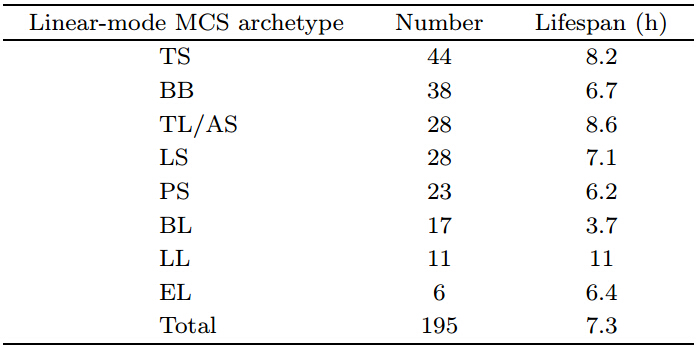
A total of 379 MCSs are identified over theY angtze River valley based on composite radar mosaicreflectivities during June and July 2010-2012(Table 1).Of these,195 are linear-mode MCSs and 184 arenonlinear-mode MCSs(51.5% and 48.5% of the total number of MCSs,respectively).The number oflinear-mode MCSs is slightly larger than the numberof nonlinear-mode MCSs during this period.

Linear-mode MCSs are classified into eight typesaccording to the organizational mode,system-relative cell movement, and general features of the system.These eight types include trailing stratiform(TS)MCSs,back-building/quasi-stationary(BB)MCSs,trailing line/adjoining stratiform(TL/AS)MCSs,leading stratiform(LS)MCSs,parallel stratiform(PS)MCSs,broken line(BL)MCSs,embedded line(EL)MCSs, and long line(LL)MCSs.The first sixtypes match the types previously proposed by studies abroad,with similarities in organizational mode,cell regeneration, and system movement.The lasttwo types,particularly LL,have never been identifiedbefore.These two newly identified types of linearmode MCS,which occur during Meiyu season overthe Y angtze River valley,are named according to theirmodal patterns.
Figure 2 shows summaries of the organizationalarchetypes of mature MCSs during the Meiyu seasonover the middle and lower reaches of the Y angtze Rivervalley with reference to previous studies.MCSs are divided into linear and nonlinear modes,with the linearmode MCSs further classified into eight subtypes asdescribed above.Nonlinear(NL)MCSs feature unorganized strong convective echoes embedded withinlarge areas of stratiform echoes.NL MCSs can moveeither rapidly or slowly, and are sometimes even quasistationary .Among the linear-mode MCSs,TS,LS,PS, and BL MCSs move rapidly,while TL/AS,BB,EB, and LL MCSs are either slow-moving or quasistationary .Precipitation in fast-moving MCSs is often light during early stages but heavy during mature stages.Heavy precipitation areas can therefore beroughly determined based on the direction and speedof MCS movement.Areas of heavy precipitation inquasi-stationary MCSs can be estimated according toradar echoes.These estimates are particularly benefi-cial for forecasts of extreme heavy precipitation.The structures of NL MCSs are more complicated thanthose of linear MCSs, and present great challenges torealistic forecasting of heavy precipitation.
 |
| Fig.2.Organizational archetypes of mature MCSs during the Meiyu season over the Yangtze River valley .Shaded areas from light to heavy correspond to composite reflectivities of 20,30, and 40 dBZ,respectively . |
Wang and Cui(2012) and Wang(2012)summarized the features of MCSs during June and July 2010based on detailed analysis of radar observ ations.Herewe give brief descriptions of several linear MCSs observed in 2011 and 2012.
(1)TL/AS MCS case: 0300-1706 BT(BeijingTime)13 July 2012
Isolated convection started at 0300 BT 13 July2012 over Xinzhou,Hubei Province under the combined effects of an upper-tropospheric trough,middletropospheric shear lines, and surface convergencelines.This isolated convection was rapidly followedby other isolated convective events over Xiaogan,Huangpi,Huanggang,Luotian, and other nearby locations.These isolated convective events merged approximately 1 h later,forming a continuous east-westchain of strong convection.This system turned intoa typical TL/AS MCS 100-km wide and 500-km long.It was quasi-stationary in the central-eastern area ofHubei Province,with strong convective echoes locatedupstream(Fig.3a).Newly-generated individual convective cells were concentrated in the upstream partof the TL/AS MCS.These new cells merged into thestrong convective line parallel to its direction of movement.Weak stratiform echoes were observed to thenorth of the convective line.This TL/AS convectivesystem started weakening around 1030 BT,althoughconvection continued developing upstream of the system.The convection merged into the weakening TL/AS MCS at about 1200 BT,converting it into a largerLL MCS that covered the area from Xuanen of Hubeito Jinzhai of Anhui.This latter system weakened and eventually disappeared around 1700 BT.The TL/ASMCS brought heavy to extremely heavy precipitationto central-eastern Hubei Province on 13 July .Themaximum precipitation(285.2 mm)was observed atHuangpi,although the maximum hourly precipitation(73.3 mm)was observed at Qianjiang.
 |
| Fig.3.Composite radar reflectivity(dBZ)for(a)a training line/adjoining stratiform(TL/AS)MCS on 13 July 2012,(b)a long line(LL)stratiform MCS on 18 June 2011,(c)a back-building/quasi-stationary(BB)MCS on 5 July 2011, and (d)an embedded line(EL)MCS on 14 June 2011 |
(2)LL MCS case: 2100 BT 17 June to 2000 BT18 June 2011
An upper-level trough was located over westernHubei Province on 17 June 2011.This trough wasaccompanied by a cyclonic vortex in the lower-midtroposphere to its southwest,over the area extending from Chongqing to western Hubei.This synoptic pattern resulted in strong wind shears in a warmair mass(hereafter warm shear)over the area fromthe western Jiang-Han Plain to eastern Hubei and theestablishment of a low level jet(LLJ)to the southof the shear line.Under these conditions,sporadicconvection developed over large areas of southwestern Hubei and the Jiang-Han Plain at approximately2100 BT.These convective cells moved northeastward and became well organized,merging into an east-west-oriented convective zone over southwestern HubeiProvince at 2300 BT.Strong echoes(larger than 45dBZ)were observed at 0000 BT along a south-northtransect extending from Dangyang,Hubei to Linli,Hunan.These strong echoes rapidly developed intoan LS MCS,which persisted for 4.5 h before splittinginto southern and northern parts.The southern partmerged into the original convective zone,further intensified and extended toward the east until it covered the entirety of southern Hubei Province and northern Hunan and Jiangxi Provinces.At its peak,theconvective zone was 350-km wide and 1000-km long and extended from southwestern Hubei to southernAnhui(Fig.3b).Newly generated convective cellsmerged into the convective zone throughout its life cycle.This merger of new convective cells ceased afterthe MCS began moving southeastward at 2000 BT 18June.This LL MCS started on 17 June and persistedfor 23 h,resulting in long-lasting heavy to extremelyheavy precipitation over large areas.Precipitationswere 265 and 253 mm in Xiantaomaozui and Tianmenhenglin,respectively .This system led to floodingthat caused severe property damage and the death ofsix people in Hubei.
(3)BB MCS case: 2100 BT 5 July to 0500 BT 6July 2011
Isolated convection developed under the influences of lower-middle level shear lines,surface convergence lines, and a weak cold air mass at 2100 BT 5July 2011 over Xiangyang,Hubei Province.These isolated convective cells rapidly organized and extendednortheastward 1 h later,forming a BB MCS 60-kmwide and 140-km long(Fig.3c).New convective cellswere initiated along the southwestern area of the convective zone of this BB MCS, and moved in the samedirection.The system remained quasi-stationary between Xiangyang of Hubei and T anghe of Henan for7 h before it dissipated,with heavy precipitation overnorthern Xiangyang,northern Zaoyang, and part ofT anghe.Despite the small horizontal extent of thisBB MCS,the precipitation was relatively intense.T otal precipitation over 7 h was between 50 and 100 mmat multiple stations.The largest values were measuredat Zaoyangxuzai(116 mm),Y angdang(92 mm), and Xiangyangshuanggou(216 mm).
(4)EL MCS case: 1900 BT 14 June to 0518 BT15 June 2011
Southwesterly flow associated with an upper-leveltrough dominated the atmosphere over the Y angtzeRiver valley on 14 June 2011.Shear lines at lowermiddle levels were observed to the north of Jiangxi and Hunan provinces, and were accompanied by an active southwesterly low level jet.Five isolated clumpsof convection with strong radar echoes developed overnorthwestern Nanchang,Jiangxi at 1900 BT 14 June.These convective clumps organized into a convectivebelt around 1900-2130 BT.Three to five short northsouth b and s of strong echo were observed within theconvective belt(Fig.3d).New convective cells continued to merge into the convective belt from the upstream and southeastern sides.Strong convection developed independently in these new cells,which thenmoved slowly within the convective belt.Some of thestrong echoes weakened and merged with the upstreamconvective system after 2130 BT,forming a typicalTL/AS MCS.This system persisted for about 12 hin northern Jiangxi before dissipating at 0518 BT 15June.This system brought heavy rain to large areasof northern Jiangxi,with the maximum precipitation(232 mm)measured at Boyang.
(5)TS MCS case: 1318-2200 BT 12 July 2012
Shear lines were located at 700 and 850 hPa overnortheastern Hubei and the northern Jiang-Han Plainon 12 July 2012,with a southwesterly low level jet located to the east of northeastern Hubei.Strong convective cells developed over Gongan,Hubei at 1318 BT12 July,triggering additional convective activity to thesouthwest and east of Gongan.These convective cellsmerged 1 h later into a strong southwest-northeastoriented convective belt moving rapidly eastward.Thestrongest radar echoes were located in the front of theconvective belt,with weak stratiform echoes in therear(Fig.4a).This configuration is typical of a TSMCS.New convective cells near the front of the system continued to merge into the TS MCS as it movedeastward.The TS MCS arrived over southwestern Anhui Province and dissipated around 2200 BT,9 h afterits initiation.This system brought heavy precipitationthroughout its path,with a maximum of 60 mm observed at Honghu.Multiple stations in southeasternHubei experienced heavy rain.
 |
| Fig.4.Composite radar reflectivity(dBZ)for(a)a trailing stratiform(TS)MCS on 12 July 2012,(b)a parallel stratiform(PS)MCS on 6 June 2011,(c)a leading stratiform(LS)MCS on 13 June 2011, and (d)a broken line(BL)MCS on 25 June 2012. |
(6)PS MCS case: 0000-0600 BT 6 June 2011
Multiple MCSs developed on 5-6 June 2011 under the influences of westerly winds associated withan upper-level trough and shear lines at lower and mid levels.Isolated convective cells developed overXiushui,Jiangxi Province at 0000 BT 6 June and moved northeastward.A convective line formed whenupstream convective cells merged into the system parallel to the northeastward direction of system movement.Strong echoes within the central convective lineintensified at this time.Weak stratiform echoes wereobserved on both sides of the area of strong convective echoes(Fig.4b).This configuration is typical of aPS MCS.The system disappeared at 0600 BT after 6h of existence.The system moved rapidly northeastward during its lifetime and caused heavy precipitation where it passed.Precipitation amounts exceeding50 mm were observed at multiple stations in this area.
(7)LS MCS case: 1800-2348 BT 13 June 2011
A transverse trough was located at 500 hPa overShaanxi and Sichuan provinces on 13 June 2011.Thistrough was accompanied by a low vortex centered at700 hPa over eastern Sichuan.Large amounts of convection developed along the riverside in Chongqingat 1800 BT 13 June.At 1912 BT these convectionsmerged into a south-north-oriented LS convection belt,with strong convective echoes at the rear of the system and stratiform echoes at the front.New convectivecells were generated near the rear of the system beforemerging into the convective belt(Fig.4c).This LSMCS weakened and eventually dissipated by 2348 BT,giving it a lifespan of approximately 5.8 h.The system caused heavy precipitation in Chongqing and westernHubei Province as it moved eastward on 13 June.
(8)BL MCS case: 1148-1824 BT 25 June 2012
Warm shear dominated the lower and mid troposphere over Hunan and northern Jiangxi on 25June 2012.Clumps of convective cells developed overGaoan,Jiangxi at 1148 BT 25 June,followed by theinitiation of isolated convective events over northeastern Hunan.These convective cells merged into a broken line MCS(Fig.4d)that extended from the northwest to the southeast with a length of 300 km and awidth of 40 km.The peak intensity of this BL MCSwas characterized by a continuous belt of weak radarechoes with six embedded blocks of strong convectiveechoes.This system persisted for 6.6 h,the longestlifetime of all BL MCSs identified during June and July of 2010-2012.It moved northeastward after itsinitiation, and brought heavy precipitation to easternHunan and northern Jiangxi.Severe rainstorms wereobserved locally,with the maximum precipitation(62mm)measured in T onggu.4.Statistical characteristics of linear-mode MCSs4.1 Spatial distribution and life cycles of linear-mode MCSs
The number and mean duration of various typesof linear-mode MCSs observed during June and July2010-2012 over the Y angtze River valley are listed inTable 2.TS,the dominant archetype among linearmode MCSs in this region,accounts for 44 out of 195MCSs.BB,the second most common type of linearmode MCSs,accounts for 38,followed by TL/AS,LS,PS,BL,LL, and EL.EL has the smallest number of occurrences(only 6 cases were observed during the studyperiod).Figure 5 shows the percentage distribution ofMCS archetypes over the Y angtze River valley during June and July 2010-2012.Nonlinear MCSs(184cases)account for 48.5% of the total cases,while linearMCSs account for 51.5% of the total.More than onefifth(22.6%)of the linear-mode MCSs are TS MCSs, and almost one fifth(19.4%)are BB MCSs.The fractions of other linear-mode MCS archetypes range from3.1% to 14.4%.
 |
 |
| Fig.5.Percentage distributions of(a)MCS archetypes among 379 identified MCSs and (b)linear-mode archetypesamong the 195 linear-mode MCSs. |
Most of these MCS archetypes have relativelylong durations.LL MCSs show particularly long durations,with a mean lifetime of 11 h.Most otherMCS types persist for more than 7 h on average,withTL/AS and TS MCSs typically lasting longer than 8h.BL MCSs are the exception with a mean lifespan ofonly 3.7 h.Note that our results are substantially different from those of Parker and Johnson(2000).Our results indicate no substantial differences in lifetimeamong the various MCS archetypes,with the sole exception of BL MCSs.By contrast,Parker and Johnson(2000)reported an average duration for TS MCSs of122 h,while the average durations of the LS and PSarchetypes were only a little longer than 6 h.The largediscrepancy between our results and those of Parker and Johnson(2000)may be explained by differences inenvironmental conditions between the Y angtze Rivervalley and North America.Although the archetypesof MCS organization are similar in many ways,theirdurations and impacts on local weather are different.4.2 Geographic locations of line ar-mode MCS generation
Figure 6 shows the areas where linear-mode MCSsover the Y angtze River valley formed during the Meiyuseason of 2010-2012.The area of formation refersto the location where convective cells are first initiated.If the initial convective cell cover a large area,its central point is taken as the representative location.Most MCSs form along the side of the Y angtzeRiver,especially in the area between Yichang(southwestern Hubei) and Wuhan(including the Jiang-HanPlain).MCS formation also occurs relatively frequently in northeastern Hunan Province,followed bythe northern and southern riverbanks near Chongqing,central-northern Hubei,southern Anhui, and northern Jiangxi.The Jiang-Han Plain and northeastern Hunan are low-lying plains with high-elevationareas to the east and west,while the sides of theY angtze River are located in a valley between mountains.MCS formation appears to be most commonover low-lying plains.Southern Anhui,northeasternHubei, and southeastern Henan are similarly locatedat the foot of Dabieshan Mountain with low elev ations.The frequency of MCS formation is also relativelyhigh over these areas.A similar situation holds forthe riverbanks near Chongqing.However,the secondhighest frequency of MCS formation is over mountainous areas of Hunan,Jiangxi, and from southern Chonqing to western Hubei.MCS formation is likely affected by mesoscale topography in regions of complexterrain.
 |
| Fig.6.Spatial distribution of linear-mode MCS formation over the Yangtze River basin during June and July 2010-2012. |
Most linear-mode MCSs over the Y angzte Rivervalley move toward the east,east-northeast,eastsoutheast,or south.The movement of MCSs is dominated by the environmental flow at middle and low levels.These winds are generally westerly or southwesterly near 30°N,resulting in eastward or eastnortheastward movement.MCSs may also movesoutheastward if they are influenced by northwesterlyflow in the rear of a trough.TS MCSs typically movethe fastest and trace the longest path.These stormstherefore typically influence larger areas(figure omitted).LS and PS MCSs are the second fastest-movingsystems.These three types of linear-mode MCS moveat roughly the speed proposed by Parker and Johnson(2000).By contrast,BL MCSs only move a short distance and tend to dissipate relatively quickly .DuringJune and July of 2010-2012,only one MCS was observed to move northward.This northward movementis due to the environmental impact of a tropical cyclone.TL/AS,BB,EL, and LL MCSs are typicallyquasi-stationary .Convection associated with thesearchetypes typically develops locally,but with a relatively large spatial extent.4.3 Diurnal variation of MCS initiationThe early development period of a MCS beginswith the initial triggering of convection and often lastsfor 2-4 h.The time of this initial triggering refers tothe time at which convection begins to develop and precedes the formation of the MCS.There are multiple peaks in the diurnal cycle of MCS initiation duringthe Meiyu season over the Y angtze River valley(Fig.7).These peaks occur at 0300-0500,0800-1100,1300-1700,2100, and 2300-0000 BT.The overall maximumoccurs at 1300-1700 BT,while the overall minimumoccurs at 0500-0700 BT.Convective activity is oftenintensified after 0800 BT,then weakened in the latemorning, and re-intensified after 1300 BT.Convec tive activity becomes weak around sunset,then redevelops between midnight and early morning.This pattern of diurnal variations may be related to the atmospheric environment over the Y angtze River valley during the Meiyu season,which is characterized by highhumidity and temperature.Most MCS archetypes include long-lasting deep moist convection,with the exception of BL MCSs(Table 2).Zheng et al.(2008)found multiple peaks in the diurnal cycle of MCSactivity over northern Hunan Province(29°N)in astatistical analysis of summertime MCSs over China.Zheng et al.(2011) and Chen et al.(2013)also identified multiple peaks in the diurnal cycle of thunderstorm and short-duration heavy rainfall activities overflat,low-lying areas in China.The existence of thesemultiple peaks is closely related to thermodynamicforcing by local and regional topography .
 |
| Fig.7.Diurnal variations in the initial time of MCSs. |
The initiation and development of an MCS isoften associated with specific synoptic-scale patterns(such as an inverted trough,front,lower-middle tropospheric shear line,cold outflow boundary,low pressurevortex,convergence or vortical circulation).Previousstudies have focused on how these patterns may trigger MCSs by forcing convergence in the lower-middletroposphere and the ascent of air parcels.However,the evolution and organization of convective cells isalso strongly affected by synoptic-scale wind fields and vertical wind shear (Parker and Johnson, 2000; Schumacher and Johnson, 2005; Zheng and Sun, 2013) .5.1 Impacts of environmental wind field and
vertic al wind she ar on line ar-mode MCSsHere,we use real-time sounding data to analyzethe environmental wind fields associated with linearmode MCSs.BL MCSs only last for short periods butsoundings are only available twice daily(0800 and 2000BT),so it is di±cult to obtain observ ations of windfields associated with BL MCSs.We therefore neglectBL MCSs in the following discussion.The EL and LL archetypes are newly identified MCS types specificto the Y angtze River valley .We lack more of such cases before we can investigate the impacts of synoptic conditions on their evolution.Among the 161identified cases of the first five types of linear-modeMCS,only those with soundings available during either the early development stage and /or the maturestage are selected for further study .These selectedcases account for approximately 50% or more of the total number of cases for each MCS type.Environmental wind fields corresponding to these selected casesare decomposed into two components: a componentparallel to the convective belt and a component perpendicular to the convective belt(hereafter referred toas the parallel wind and the perpendicular wind,respectively).These wind components are calculated ateach st and ard pressure level based on sounding datafor every case that meets the criteria.The results arecomposited by archetype to obtain the typical environmental wind fields associated with each MCS type.The availability of sounding data at st and ard levels islimited.Here,we restrict the analysis to the environmental wind fields at 925,850-700,500-400, and 300hPa.These levels represent the environmental windfields in the lower,mid, and upper troposphere.
Figure 8 shows composite vertical profiles of theenvironmental wind components for each MCS type.As discussed above,the environmental wind is decomposed into components parallel and perpendicular tothe convective belt.The two middle levels representaverages at 850-700 and 500-400 hPa,respectively .Negative values in the perpendicular wind component indicate that the environmental wind is oriented opposite to the direction of convective system movement,while positive values indicate that it is oriented in thedirection of convective system movement.
 |
| Fig.8.Vertical profiles of storm-relative MCS winds(m s-1)for five types of linear-mode MCSs.The arrowheads indicate the parallel(↑) and perpendicular(←)components. |
For TS MCSs,the composite perpendicular windis negative from the surface to the upper troposphere(i.e.,its direction is toward the stratiform areaat the rear of the convective system).The maximum perpendicular wind occurs in the lower-mid troposphere, and the magnitude of the perpendicularwind gradually decreases with height.The magnitude of the parallel wind increases with height in thelower troposphere,decreases slightly in the mid troposphere and increases again in the upper troposphere.The composite environmental winds associated withTL/AS MCSs are similar to those associated withTS MCSs,with large perpendicular winds near thesurface that decrease with height and parallel windsthat are small near the surface but increase signifi-cantly with height.F or LS MCSs,the composite perpendicular winds increase with height,with negativevalues below 700 hPa and positive values above 700hPa.Composite parallel winds increase with height,similar to those associated with TS and TL/AS MCSs.The composite parallel winds associated with BB and PS MCSs are large when compared with the composite perpendicular winds,especially for PS MCSs.The perpendicular winds associated with PS MCSsare small.The magnitude of these winds first decreases with height, and then increases slightly beforedecreasing again.The perpendicular winds associatedwith BB MCSs are larger than those associated withPS MCSs,with magnitudes that slowly increase withheight.The direction of the perpendicular wind isto the left of the direction of system movement in thelower-mid troposphere but to the right of the directionof system movement at upper levels.F or PS MCSs,the direction of the perpendicular wind is to the leftof the direction of system movement near the surfacebut to the right in the mid-upper troposphere.
These results indicate that the perpendicularwind components associated with TS and TL/ASMCSs are different from those associated with theother three MCS archetypes.The composite perpendicular winds associated with TS and TL/AS MCSsare negative throughout the troposphere,meaningthat they point toward the rear of the convective system,against the direction of movement.The magnitudes of the perpendicular wind components near thesurface are also larger than the magnitudes associatedwith the other three MCS archetypes.This differenceis especially pronounced for TL/AS MCSs,in whichthe magnitude of the perpendicular wind can be aslarge as 11.2 m s-1.The perpendicular wind component in the mid troposphere is significantly largerfor TS MCSs than for all other MCS types.This result is consistent with the results reported by Parker and Johnson(2000).The magnitude of the perpendicular component is small throughout the verticalcolumn in PS MCSs.The composite perpendicularwind components in the mid troposphere in LS and BB MCSs are similar.Rutledge and Houze(1987) and Houze et al.(1989)suggested that large moistureadvection toward the rear of an MCS was a necessaryprecondition for the existence of stratiform precipitation there.Parker and Johnson(2000)found muchstronger vertical winds near the surface than at higherlevels.Our results indicate larger mean winds thanthose reported by Parker and Johnson(2000),probably because strong southeasterly winds dominate during summer over China.
The parallel wind associated with the PS MCSarchetype is much larger than the perpendicular windover a deep layer in the upper troposphere(above 500hPa).Moisture advection in the mid and upper troposphere therefore follows the direction of the parallelwind for all PS MCSs.The composite parallel windassociated with BB MCSs is only slightly weaker thanthat for PS MCSs.This result suggests that moistureadvection parallel to the direction of system movement is larger than moisture advection perpendicularto the direction of system movement for a typical BBMCS.This means that most precipitation will be concentrated along the convective line,just like for PSMCSs.The perpendicular and parallel wind components are similar in magnitude for LS MCSs,althoughparallel wind increases with height.The perpendicular wind is positive in the mid and upper troposphere(i.e.,it points toward the front of the convective line,where the stratiform echo area is typically located).The magnitude of the perpendicular wind is also relatively large,which partially explains the existence oflarge moisture advection toward the front of the system.The parallel wind is stronger than the perpendicular wind in the mid and upper troposphere(above500 hPa)in TL/AS MCSs.The parallel winds associated with all five types of MCS have similar features inthe troposphere,i.e.,they are weak at lower levels butstrong at upper levels.However,the magnitudes ofthe parallel and perpendicular wind components differ substantially among these different types of MCS.This result implies that the vertical profile of environmental winds is an important factor in determiningthe mode of MCS organization.
We have also calculated the vertical wind shear inthe surface layer and in the mid troposphere.V erticalwind shear is largely perpendicular to the convectionline in TS and LS MCSs.By contrast,the wind shearin TL/AS MCSs is perpendicular to the convectionline in the surface layer but parallel to the convectionline in the mid and upper troposphere.This is themost significant difference in the vertical structure ofwind shear among these three archetypes.The verticalwind shear in PS and BB MCSs is oriented parallel tothe convection line from the surface to the mid troposphere.The wind shear in BB MCSs is smaller thanthat in PS MCSs.These results indicate that vertical wind shear also affects modes of organization inlinear-mode MCSs.5.2 Characteristics of envir onmental fields for line ar-mode MCSs
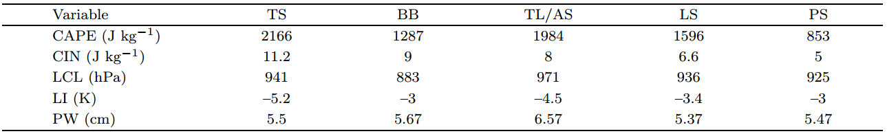
The duration of MCSs is often related to the stability of the air mass.We calculate various thermodynamic variables from upper air radiosonde observations in the most unstable layer for various typesof MCSs.The most unstable layer differs for different MCS cases,but is often close to the surface.Theresults are shown in Table 3.The mean values of convective available potential energy(CAPE),convectiveinhibition(CIN),lifting condensation level(LCL), and lifted index(LI)suggest that TS MCSs form under themost unstable conditions.The conditions under whichTL/AS,LS, and BB MCSs form are progressively lessunstable, and PS MCSs typically develop under theleast unstable conditions.There is no clear relationship between atmospheric stability and precipitablewater(PW)during Meiyu season over the Y angtzeRiver valley .The average PW is large for all MCStypes,much larger than that observed in midlatitudesover the United States (Parker and Johnson, 2000) .PW is the largest and the LCL the lowest for TL/ASMCSs.The second largest PW is associated with BBMCSs,but the LCL for these storms is relatively high(above 883 hPa).Mean PW decreases progressivelyfor TS,LS, and PS MCSs.
 |
This study has investigated the characteristicsof MCSs during June and July 2010-2102 over theY angtze River basin.A statistical analysis of composite reflectivity from the regional radar mosaic and various observ ations is performed.After developinga classification for the observed linear-mode MCSs,we have focused on characterizing the durations,geographic distributions, and diurnal variations of eachtype,as well as the environmental conditions under which they form.The results are summarized as follows.
(1)MCSs over the Y angtze River valley can beclassified into two main types: linear-mode MCSs and nonlinear-mode MCSs.The occurrence of linear-modeMCSs is slightly higher than that of nonlinear-modeMCSs during the study period.Eight types of linearMCSs are identified: trailing stratiform(TS),leading stratiform(LS),trailing line/adjoining stratiform(TL/AS),back-building/quasi-stationary(BB),parallel stratiform(PS),broken line(BL),embedded line(EL), and long line(LL).TS,LS,PS, and BL MCSsare moving systems.TS MCSs have the fastest averagespeed,followed by LS and BL MCSs.PS MCSs are theslowest of the moving systems.TL/AS,BB,EL, and LL MCSs are quasi-stationary and move slowly .Withthe exception of BL MCSs,all types of MCS typicallybring heavy precipitation to all areas in their paths.Heavy precipitation is especially pronounced for thequasi-stationary and slow-moving types,which oftencause extremely heavy rainfall in local areas.The average duration of linear mode MCSs is longer than 7h.TL/AS and TS MCSs are the longest-lived,whileBL MCSs have the shortest lifespan of 3.7 h.
(2)Linear-mode MCSs are typically generatedalong the riverside in the Y angtze River valley .Thehighest occurrence of MCS initiation is located in lowlying areas along the river from Yichang to Wuhanto northeastern Hunan.MCS initiation is also relatively common over the riverside areas in northern Chongqing,the low-elevation area from southernChongqing to western Hubei,the region at the footof Dabieshan Mountain,the mountainous area alongthe border between Hunan and Jiangxi, and low-lyingplains and valleys.MCSs typically move toward theeast,east-northeast,east-southeast or south,depending on the large-scale environmental flow.
(3)The diurnal cycle of MCS initiation over theY angtze River valley has multiple peaks.This diurnalcycle shares many characteristics with the diurnal cycle of moist convection.
(4)The composite wind component oriented perpendicular to the convective belt is large and its magnitude increases with height for both TS and TL/ASMCSs.The perpendicular wind component for LSMCSs is negative in the lower troposphere but positivein the mid and upper troposphere.The parallel windcomponent increases with height for all three of theseMCS types.The vertical wind shear is generally oriented perpendicular to the convection line in the midtroposphere for TS and LS MCSs,but is oriented parallel to the convection line for TL/AS MCSs.The parallel wind component increases with height throughout the troposphere for PS and BB MCSs,with thisincrease more pronounced for PS MCSs than for BBMCSs.The vertical wind shear is relatively weak and oriented parallel to the convection line for both PS and BB MCSs, and is slightly larger for PS MCSs than forBB MCSs.
(5)Linear-mode MCSs form in unstable atmospheric environments.The conditions are most unstable for TS MCS initiation,followed by TL/AS,LS, and BB.The conditions are the least unstable for PS MCSinitiation.There is no clear relationship between atmospheric stability and PW during the Meiyu seasonover the Y angtze River valley .
Acknowledgments: Radar mosaic information,conventional surface and upper air soundingobserv ations, and intensive observ ations are providedby the Meteorological Information Center of the ChinaMeteorological Administration.The language editorfor this manuscript is Dr.Jonathon S.Wright.
| Bluestein, H.B., and M.H.Jain, 1985: Formation of mesoscale lines of precipitation: Severe squall lines in Oklahoma during the spring. J.Atmos.Sci.,42(16), 1711-1732. |
| —-, G.T.Marx, and M.H.Michael, 1987: Formation of mesoscale lines of precipitation: Nonsevere squall lines in Oklahoma during the spring. Mon.Wea.Rev., 115(11), 2719-2727. |
| Chen Jiong, Zheng Yongguang, Zhang Xiaoling, et al., 2013: Distribution and diurnal variation of warm-season short-duration heavy rinfall in relation to the MCSs in China. Acta Meteor.Sinica, 27(6), 868-888. |
| Emanuel, K.A., 1986: Overview and definition ofmesoscale meteorology.Mesoscale Meteorology andForecasting, P.S.Ray, Ed., Amer.Meteor.Soc.,1-16. |
| Gallus Jr., W.A., N.A.Snook, and E.V.Johnson, 2008: Spring and summer severe weather reports over the Midwest as a function of convective mode: A pre-liminary study. Wea.Forecasting, 23(1), 101-103. |
| Houze Jr., R.A., 1993: Cloud Dynamics, InternationalGeophysics Series.Vol.53.Academic Press, 53 pp. |
| —-, M.I.Biggerstaff, S.A.Rutledge, et al., 1989: In-terpretation of Doppler weather radar displays of midlatitude mesoscale convective systems. Bull.Amer.Meteor.Soc., 70(6), 608-619. |
| —-, B.F.Smull, and P.Dodge, 1990: Mesoscale organi-zation of springtime rainstorms in Oklahoma. Mon.Wea.Rev., 118(3), 613-654. |
| Jirak, I.L., W.R.Cotton, and R.L.McAnelly, 2003: Satellite and radar survey of mesoscale convective system development. Mon.Wea.Rev., 131(10),2428-2449. |
| Loehrer, S.M., and R.H.Johnson, 1995: Surface pres-sure and precipitation life cycle characteristics of pre-storm mesoscale convective systems. Mon.Wea.Rev., 123(3), 600-621. |
| Ma Yu, Wang Xu, and Tao Zuyu, 1997: Spatial andtemporal distribution characteristic of mesoscale convective systems in China and neighboring areas.Prog.Nat.Sci., 7(6), 63-68.(in Chinese) |
| MacGorman, D.R., and C.D.Morgenstern, 1998: Some characteristics of cloud-to-ground lightning in mesoscale convective systems. J.Geophys.Res.,103(D12), 14011-14023. |
| Meng, Z.Y., D.C.Yan, and Y.J.Zhang, 2013: General features of squall lines in East China. Mon.Wea.Rev., 141(5), 1629-1647. |
| Parker, M.D., and R.H.Johnson, 2000: Organizationalmodes of midlatitude mesoscale convective systems.Mon.Wea.Rev., 128(10), 3413-3436. |
| Rigo, T., and M.C.Llasat, 2004: A methodology for the classification of convective structures using meteo-rological radar: Application to heavy rainfall events on the mediterranean coast of the Iberian Peninsula. Natural Hazards and Earth System Sciences, 4(1),59-68. |
| —-, and M.C.Llasat, 2007: Analysis of mesoscale con-vective systems in Catalonia using meteorological radar for the period 1996-2000.Atmospheric Re-search, 83(2-4), 458-472. |
| Rutledge, S.A., and R.A.Houze Jr., 1987: A diagnostic modelling study of the trailing stratiform region of a midlatitude squall line. J.Atmos.Sci., 44(18),2640-2656. |
| Schiesser, H.H., R.A.Jr.Houze, and H.Huntrieser, 1995: The mesoscale structure of severe precipita-tion systems in Switzerland. Mon.Wea.Rev.,123(7), 2070-2097. |
| Schumacher, R.S., and R.H.Johnson, 2005: Orga-nization and environmental properties of extreme-rain-producing mesoscale convective systems. Mon.Wea.Rev., 133(4), 961-976. |
| Wang Xiaofang, 2012: Analysis of the linear mesoscale convective systems during the Meiyu period in the middle and lower reaches of the Yangtze River. Part II: Environmental characteristics.Acta Me-teor.Sinica, 70(5), 924-935.(in Chinese) |
| —- and Cui Chunguang, 2011: A number of advances of the research on heavy rain mesoscale convective sys-tems.Torrential Rain and Disasters, 30(2), 97-106.(in Chinese) |
| —- and —-, 2012: Analysis of the linear mesoscale convective systems during the Meiyu period in the middle and lower reaches of the Yangtze River. Part I: Organization mode features.Acta Meteor.Sinica,70(5), 909-923.(in Chinese) |
| Yue Zhiguo, Niu Shengjie, and Liang Gu, 2008: Structure models and disaster analyses of mesoscale convec-tive systems in Weibei area of Shaanxi Province.J.Nanjing Ins.Meteor., 31(3), 395-402.(in Chinese) |
| Zheng Linlin and Sun Jianhua, 2013: Characteristics of synoptic and surface circulation of mesoscale con-vective systems in dry and moist environmental conditions.Chinese J.Atmos.Sci., 37(4), 891-904.(in Chinese) |
| —-, —-, and Wei Jie, 2011: The diurnal variation of thunder events in China.Torrential Rain and Dis-asters, 30(2), 137-144.(in Chinese) |
| —-, —-, Zhang Xianlong, et al., 2013: Organizational modes of mesoscale convective systems over central East China. Wea.Forecasting, 28(5), 1081-1098. |
| Zheng Yongguang, Chen Jiong, and Zhu Peijun, 2008: Climatological distribution and diurnal variation of mesoscale convective systems over China and its vicinity during summer. Chinese Sci.Bull., 53(10),1574-1586. |