 2012, Vol. 26
The Chinese Meteorological Society
Article Information
- Zheng Ziyan, Zhang Wanchang, Xu Jingwen, ZHAO Linna, CHEN Jing, and YAN Zhongwei. 2012.
- Numerical Simulation and Evaluation of a New Hydrological Model Coupled with GRAPES
- J. Meteor. Res., 26(5): 653-663
- http://dx.doi.org/10.1007/s13351-012-0509-1
-
Article History
- Received December 9, 2011
- in final form June 28, 2012


2 University of the Chinese Academy of Sciences, Beijing 100049;
3 Center for Earth Observation and Digital Earth, Chinese Academy of Sciences, Beijing 100094;
4 College of Resources and Environment, Sichuan Agricultural University, Yaan 6250145;
5 National Meteorological Center, China Meteorological Administration, Beijing 100081
For the model evaluation and comparison, we perform 72-h online simulations using GRAPES-XXT and GRAPES-SWB during two torrential events in August 2007 and July 2008, respectively. The results show that GRAPES can reproduce the rainfall distribution and intensity fairly well in both cases. Differences in the representation of feedback processes between surface hydrology and the atmosphere result in differences in the distributions and amounts of precipitation simulated by GRAPES-XXT and GRAPES-SWB. The runoff simulations are greatly improved by the use of XXT in place of SWB, particularly with respect to the distribution and amount of runoff. The average runoff depth is nearly doubled in the rainbelt area, and unreasonable runoff distributions simulated by GRAPES-SWB are made more realistic by the introduction of XXT. Differences in surface soil moisture between GRAPES-XXT and GRAPES-SWB show that the XXT model changes infiltration and increases surface runoff. We also evaluate river flood discharge in the Yishu River basin. The peak values of flood discharge calculated from the output of GRAPES-XXT agree more closely with observations than those calculated from the output of GRAPES-SWB.
The development of more realistic and detailedl and surface schemes to couple with atmospheric modelshas become a topic of vigorous research in recentyears(Seneviratne et al., 2006; Wood et al., 1992).Numerous studies have shown the importance of l and surface processes in atmospheric modeling(Yu et al., 2006; Zen et al., 2003; Chen and Dudhia, 2001). Inorder to simulate l and -atmosphere interactions and describe the feedbacks to the atmosphere from l and surface processes more precisely, many numericalexperiments coupling l and surface models(LSM)withnumerical weather prediction models(NWPM)havebeen conducted during the last two decades underthe auspices of the World Climate Research Program(WCRP) and the Global Energy and Water Cycle Experiment(GEWEX). Seuffert et al.(2002)found thatimprovements in the representation of hydrologicalrunoff processes improve predictions of energy fluxes and precipitation. However, due to the complexity and computational expense of the atmospheric models, thehydrological modules in the LSM components of coupledNWPM-LSM models tend to be greatly simplified, especially in the runoff parameterization scheme.
Runoff is one of the key components of the waterbalance in an LSM, and it has significant feedbacks tothe lower atmosphere on a variety of temporal and spatialscales(Yu et al., 2006). For example, runoff c and irectly affect the regional atmospheric budgets of water and energy over a range of timescales(Liang and Xie, 2001). Poor representations of runoff mechanisms and a lack of consideration of spatial variability can resultin significant errors in simulated runoff, which canin turn lead to large errors in the simulated state ofsoil moisture throughout the modeling domain. Bettset al.(1996)suggested that a proper runoff schemeis essential to a reasonable representation of feedbacks and interactions in the atmosphere-l and system. Theaccuracy of this statement has been illustrated clearlyby several previous LSM studies. A better calculationof runoff can improve simulations of precipitation, soilconditions, and floods, and can even enhance the estimation and evaluation of future water resources(Zen et al., 2003).
Thus, creating a realistic representation of hydrologicalrunoff processes is an essential step in the developmentof any LSM. This task is an ongoing effortwithin the research community(Rosero et al., 2009).Most current LSMs used to simulate atmospherel and surface interactions do not include a hydrologicalscheme with a detailed runoff generation mechanism.Several studies have shown that modifying thehydrological module in an LSM can improve the modelsimulations of atmosphere-l and surface processes and may further improve the accuracy of model predictions(Dirmeyer et al., 2000; Chen and Dudhia, 2001; Jiang et al., 2009; Niu et al., 2005, 2007).
A new hydrological model named XXT is developedin this study. XXT, which is based on the Xinanjianghydrological model(XAJ) and TOPMODEL, is intended to improve upon the previous-generationhydrological runoff parameterization in the NationalCenters for Environmental Prediction-Oregon StateUniversity-Air Force-Hydrologic Research Laboratory(Noah)LSM. This new runoff parameterization dynamicallyconnects surface and subsurface runoff accordingto water table depth, which is closely connectedto the local l and surface water balance. Yuanet al.(2008a)showed that water table dynamics affectregional climate through local aquifer-atmosphereinteractions, and that ambient aquifer-atmosphere interactionseffected changes in atmospheric circulation.The latter factor plays an important role in the monsoonarea(Yuan et al., 2008b). The key innovationof the new runoff scheme is the introduction of watertable depth into the formula for calculating thesoil moisture storage capacity distribution curve(SMSCC)in XAJ. The modified Noah LSM is then integratedinto the Global/Regional Assimilation and Prediction System(GRAPES) and used to performtwo-way coupled atmosphere-l and surface simulations(GRAPES-XXT). We use two case studies to evaluatethe performance of the GRAPES-XXT relative tothat of GRAPES coupled with the simple water balancemodel(SWB)(GRAPES-SWB). The details ofthe models are described in Section 2. The experimentaldesign, model performance and results are presented and discussed in Section 3. A brief summary isprovided in Section 4.2. Model description2.1 The GRAPES model
GRAPES is a homemade numerical meteorologicalprediction system(Zhang and Shen, 2008). Thissystem includes the following components: variationaldata assimilation(3DVAR/4DVAR), a full compressiblenonhydrostatic model core with a semi-implicit and semi-Lagrangian discretization scheme, a modularizedmodel physics package(Chen et al., 2008).The GRAPES framework incorporates a multi-scaledynamical core, which can be used as a common basemodel for a variety of applications. The dynamicalcore is designed with a range of options includingstatic or non-static, global or regional, and a range ofhorizontal and vertical resolutions(Zhang and Shen, 2008). The GRAPES variational assimilation systemcan assimilate not only regular meteorological observationaldata, but also satellite-based direct radiationdata, remote sensing data derived from Dopplerweather radar, and satellite remote sensing products(e.g., clouds and winds). The grid in the model systemis designed as an Arakawa C horizontal grid witha Charney-Philips structure in the vertical direction(Xue and Chen, 2008). Several model tests and validationexperiments have been performed, and the resultsindicate that GRAPES provides good simulations and forecasts of precipitation over China(Ye et al., 2006;Zhang and Zhong, 2009; Yang et al., 2008).2.2 The XXT hydrological model
In this study, the Noah LSM provided for use withGRAPES is modified to include the XXT hydrologicalmodule developed by Schaake et al.(1996). Thishydrological module improves the conceptual realismof l and surface hydrological processes in ways that alleviateknown biases and poor energy partitioning inthe SWB, even after model calibration(Chen et al., 2007). The poor spatial heterogeneity of soil properties and topography in the SWB is often highlightedas the main reason for its significant underestimationsof runoff.
The XXT model is constructed by introducing aparameter for water table depth x into the formulafor SMSCC used in XAJ(Zhao, 1984), and then integratingit with TOPMODEL(Beven and Kirkby, 1979). The surface runoff yield in XXT is dynamicallyrelated to subsurface runoff by x, while theschemes for calculating evapotranspiration resemblethose of TOPMODEL. The runoff generation schemein XXT is similar to saturation excess runoff. Therunoff routing scheme adopts the digital elevationmodel(DEM)-based isochrone method. The XXT hasbeen calibrated and validated in both arid and humidbasins in China, where its performance is better thanXAJ and TOPMODEL(Xu et al., 2010, 2012). Theperformance of XXT indicates sufficient skills for itsoperational application. The XXT is integrated withGRAPES to build a two-way coupled atmospherehydrologymodel system. The detailed structure ofthe XXT model is described in Fig. 1.
 |
| Fig. 1. Architecture of the XXT model. |
The general technique for coupling an NWPMwith a hydrological model is the one-way method thatincorporates the hydrological model according to theoutput of the NWPM. This one-way coupling does notprovide a physically consistent description of the hydrologicalcycle. In the one-way coupling technique, the NWPM and the hydrological model are run individually and do not share the results of the LSM. As aconsequence, the hydrological model cannot improvethe calculations of soil water content and evaporationaccording to real-time atmospheric forcing, and theNWPM cannot dynamically modify the l and surfaceenergy and water balance according to the output ofthe hydrological model.
Due to the weakness of the link between theNWPM and the hydrological model that is establishedby the one-way coupling method, we adopt a two-waycoupling technique in this study. In this technique, the NWPM and the hydrological model use the sameLSM during the simulation period. Feedback from thehydrological model to the NWPM is therefore able toaffect the NWPM simulation in the next integrationtime step. Several previous studies have used two-waycoupling between atmospheric and hydrological models.Seuffert et al.(2002)coupled a mesoscale climatemodel(Lokal Model)to a l and surface hydrologicalmodel named TOPLATS(TOPMODEL-Based L and Surface-Atmosphere Transfer Scheme)for on-line simulations.Yu et al.(2006)built the large-scale hydrologicalmodel HMS(which was based on the output ofthe l and surface model in the GENESIS global climatemodel), and obtained successful results in several watersheds.Niu et al.(2007)added the groundwatermodel SIMGM into the LSM component of a climatemodel and achieved good performance in simulationsof total water storage. These studies have shown thattwo-way coupling between NWPMs and hydrologicalmodels holds considerable promise.3. Experiments and results3.1 Experimental design
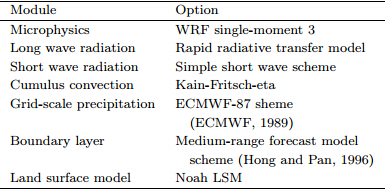
Our experiment is designed to validate the capability and performance of the coupled GRAPES-XXTmodel system. Two summer torrential rain eventsin the East Asian monsoon region of China are selected.Both simulations are run for 72 h from 0800BT(Beijing Time)17 August 2007 and 0800 BT 21July 2008, respectively. The simulation domain is centeredat 39.75°N, 107.65°E. There are 502×330 gridpoints with a horizontal resolution of 0.15 decimal degrees, and the model domain covers the entire territoryof China. Both simulations include 3DVAR data assimilation.The chosen physics modules are listed inTable 1.
We simulate river flood discharge using the routingmodule of XXT in the final part of our experiment, with a particular focus on the Yishu River basinin Sh and ong Province. The Linyi hydrological stationobserves flood discharge accumulated from theupstream catchment. The Yishu River basin has anarea of approximately 10040 km2, and lies in a semiarid and semi-humid region with an average annualprecipitation of approximately 800 mm. There areseveral mountains upstream; Linyi station is locatedin the outlet. An overview of the study basin is shownin Fig. 2.
 |
| Fig. 2. An outlook of the Yishu River basin. |
Figtures 3 and 4 show observations and simulationsof precipitation in 2007 and 2008, resptectively.The differences between GRAPES-XXT and GRAPES-SWB are also shown. The observationaldistribution is interpolated from approximately 1000national benchmarks over China using an inverse distanceweight method(IDW).
 |
| Fig. 3. Precipitation from 17 to 20 August 2007.(a)Simulated by GRAPES-SWB, (b)simulated by GRAPES-XXT, (c)observation, and (d)differences between GRAPES-XXT and GRAPES-SWB. |
 |
| Fig. 4. As in Fig. 3, but for precipitation from 21 to 24 July 2008. |
The results shown in Figs. 3 and 4 indicate thatGRAPES is able to reproduce the “southwest-northeast”-oriented rainbelt in each case fairly well regardlessof whether XXT or SWB is used. In the2007 case, the intensity of rainfall over the LiaotungPeninsula and Sh and ong Province is too low in theGRAPES simulations, and the intense rainfall alongthe southeastern coast is almost entirely absent fromthe model results. The center of the rainstorm in 2008, which is located in the southern regions of Henan and Sh and ong provinces and the western part of HubeiProvince, is captured well by the model system. Observedprecipitation amounts exceed simulated precipitationamounts in both cases. Both models underestimatethe precipitation, especially in the east of Zhejiang and Fujian provinces in 2007 and in Chongqing, Guizhou, and southern Sh and ong in 2008. A comparisonof the precipitation distributions simulatedby GRAPES-XXT and GRAPES-SWB indicates thatthe effects of feedbacks from l and surface hydrologicalprocesses to the atmosphere are substantial inthe rainbelt area. GRAPES-XXT simulates higherprecipitation amounts than GRAPES-SWB over mostparts of China in 2007, including the southern regionsof Hebei and Shanxi provinces, and parts of Sh and ongProvince. GRAPES-XXT simulates lower precipitationamounts than GRAPES-SWB over HenanProvince in 2008. The new runoff parameterizationchanges the allocation of precipitation and the amountof water vapor in the surface layer of the atmosphere, which is the main source of precipitation in summer.The average amount of precipitation simulatedby GRAPES with XXT and SWB is in qualitativeagreement(figure omitted), due to the short simulationperiods. This difference would likely be larger inlong-term climate simulations.
In summary, GRAPES-XXT and GRAPES-SWBperform well in reproducing the amount and distributionof precipitation in our case study experiments.The differences between GRAPES-XXT and GRAPES-SWB indicate close interactions betweenhydrological and atmospheric processes, which impactsimulations of mesoscale precipitation.3.4 Runoff depth estimation
Figures 5 and 6 show the accumulated runoffdepth(including surface and subsurface runoff)duringthe 72-h periods simulated by GRAPES-SWB and GRAPES-XXT in the two cases. The SWB modelproduces a runoff depth that is too shallow, resultingin an excessively dry l and surface. The weak responsewithin the rainbelt area, where the soil is near saturationduring the wet summer, indicates that this resultis unrealistic. Figure 6 shows an almost completelack of accumulated runoff in the southern regions ofHenan and Sh and ong provinces, which are the locationsthat experienced the most precipitation duringthe 2008 case. Figure 5 shows that GRAPES-XXTproduced a much deeper runoff depth for the 2007case that corresponds more closely with the observedpattern of rainfall. Clearly, including the dynamic watertable depth in the XXT hydrological scheme improvessimulations of runoff depth and increases runoffamounts remarkably. The GRAPES-XXT results correspondmore closely with the observed rainbelt area, and the runoff depth is notably greater than that inGRAPES-SWB. The differences between the modelsare concentrated in areas of high rainfall. The inclusionof the XXT model enables the modeling systemto more accurately capture the main runoff yield areaafter both torrential rain events.
 |
| Fig. 5. Accumulated runoff depth simulated by(a)GRAPES-SWB and (b)GRAPES-XXT, and (c)their differencefor the 2007 case, along with(d)observed precipitation for comparison. |
 |
| Fig. 6. As in Fig. 5, but for the 2008 case. |
The average runoff depth simulated by both modelsover the main rainbelt is calculated and plottedin Fig. 7 for comparison. The runoff amount ismuch larger in GRAPES-XXT than in GRAPES-SWBfor approximately the same simulated precipitationamount. We thus conclude that coupling XXT withGRAPES produces more realistic estimates of runoff and improves the potential of using GRAPES for predictingflood risk.
 |
| Fig. 7. Comparisons of mean runoff depth over the rainbelt areas denoted by the red rectangles in Fig. 5d for(a)the2007 case and that in Fig. 6c for(b)the 2008 case. |
Surface soil moisture has a large impact on bothmeso- and micro-scale atmospheric processes, especiallysevere local convective events and the dynamicsof short-lived torrential rains. Soil moisture is a dominantfactor in the occurrence of torrential rain flashflood events because it controls the amount of surfacerunoff, which is the source of the water that makesup the flood. We calculate differences between surfacesoil moisture simulated by GRAPES-XXT and thatsimulated by GRAPES-SWB at 2100 BT 18 August2007 for the first case and 0800 BT 23 July 2008 forthe second case(Fig. 8). Relative to GRAPES-SWB, GRAPES-XXT simulates more surface soil moisturein 2007 and less surface soil moisture in 2008. Thesedifferences are especially pronounced in the rainbeltpattern, where they can be as large as 0.2 and –0.15m3 m−3, respectively. This result may be attributableto the increased precipitation produced by GRAPESXXTin 2007, as well as the differences in infiltrationbetween the bucket approximation used in SWB and the parabola equation used for SMSCC in XXT. Relativeto the GRAPES-SWB results, the GRAPES-XXTresults suggest higher risks of flash flood occurrenceduring the torrential rain. This result also suggeststhat the runoff parameterization plays an importantrole in the evaluation of surface soil moisture. Improvementsin the runoff scheme coupled to an NWPMtherefore have broad implications for operational floodwarning and risk management.
 |
| Fig. 8. The difference of 10-cm depth soil water content between GRAPES-XXT and GRAPES-SWB in the cases of(a)2007 and (b)2008. |
We calculate simulated river flood discharge usinga DEM-based isochrone routing method in the studybasin. The results for GRAPES-XXT and GRAPESSWBare shown in Fig. 9, along with observationsderived from the Linyi hydrological station. NeitherGRAPES-XXT nor GRAPES-SWB discharge curvescorrespond well with the observations at the beginningsof the floods in these two cases. This initialmismatch is due to the dry bias in simulated precipitationproduced by the NWPM. As the flood evolves, however, GRAPES-XXT is able to capture the floodpeaks and reproduce the trends in river discharge evolutionbetter than GRAPES-SWB in both cases. Theflood discharge simulated is greatly underestimated byGRAPES-SWB throughout the evolution of the flood, likely due to the inability to properly simulate runoffdepth(Figs. 5 and 6). The most likely reason for thetemporal mismatches between GRAPES-XXT and theobservations is that the hourly evolution of the distributionof precipitation was not described well by theGRAPES model in the study basin.
 |
| Fig. 9. River flood discharges simulated by GRAPES-XXT and GRAPES-SWB. |
This paper describes the application of a newrunoff parameterization scheme XXT. We developedXXT and coupled it with GRAPES to simulate twotorrential rain events. We have also compared theresults of this GRAPES-XXT simulation with the resultsof a coupled GRAPES-SWB system.
Our results show that improving the runoff parameterizationin the GRAPES modeling system feedsback into simulations of precipitation in the observedrainbelt area. Both GRAPES-XXT and GRAPESSWBreproduced a distribution of rainfall that agreeswell with observations, although the intensity isslightly weak. GRAPES-XXT produced larger valuesof runoff depth consistent with the location of therainbelt, while GRAPES-SWB produced values thatwere too shallow. The results from GRAPES-XXThighlight the boundaries of the area of high runoff, which is valuable for flood warning and prevention.The surface soil moisture simulated by GRAPESXXTindicates that the new runoff scheme changesthe soil infiltration, affecting the surface soil layer and increasing the runoff yield. Calculations of riverflood discharge from both models show that GRAPEScoupled with XXT can describe the evolution of flooddischarge more effectively than GRAPES coupled withSWB.
This study demonstrates the advantages of couplinga NWPM with a proper runoff parameterization, and shows that a realistic representation of runoff is anecessary component of the coupled NWPM-LSM system.Future work, including experiments over longertime integrations, is needed to more fully validate themodel.
Acknowledgments. The authors would liketo thank Linyi Meteorological Bureau for providingthe hydrological data. The reviewers’ comments contributedsubstantially to the publication of this work.
| [1] | Betts, A. K., J. H. Ball, A. C. M. Beljaars, et al., 1996: The land surface-atmosphere interaction: A review based on observational and global modeling perspectives. J. Geophys. Res., 101(D3), 7209–7225. |
| [2] | Beven, K. J., and M. J. Kirkby, 1979: A physically based variable contributing area model of basin hydrology. Hydrol. Sci. Bull., 43(1), 43–69. |
| [3] | Chen Dehui, Xue Jishan, Yang Xuesheng, et al., 2008: New generation of multi-scale NWP system (GRAPES): General scientific design. Chinese Sci. Bull., 53, 3433–3445. |
| [4] | Chen, F., and J. Dudhia, 2001: Coupling an advanced land surface-hydrology model with the Penn State-NCAR MM5 modeling system. Part I: Model implementation and sensitivity. Mon. Wea. Rev., 129, 569–585. |
| [5] | —–, K. W. Manning, M. A. Lemone, et al., 2007: Description and evaluation of the characteristics of the NCAR high-resolution land data assimilation system. J. Appl. Meteor. Climatol., 46, 694–713. |
| [6] | Dirmeyer, P. A., F. J. Zeng, A. Ducharne, et al., 2000: The sensitivity of surface fluxes to soil water content in three land surface schemes. J. Hydrometeorol., 1, 121–134. |
| [7] | ECMWF, 1989: ECMWF Forecast Model Physical Parameterization. Research Manual 3, ECMWF. |
| [8] | Hong, S.-Y., and H.-L. Pan, 1996: Nocturnal boundary layer vertical diffusion in a medium-range forecast model. Mon. Wea. Rev., 124, 2322–2339. |
| [9] | Jiang, X., G. Y. Niu, and Z. L. Yang, 2009: Impacts of vegetation and groundwater dynamics on warm season precipitation over the central United States. J. Geophys. Res., 114, D06109. |
| [10] | Liang, X., and Z. H. Xie, 2001: A new surface runoff parameterization with subgrid-scale soil heterogeneity for land surface models. Adv. Water Resour., 24(9–10), 1173–1193. |
| [11] | Niu, G. Y., Z. L. Yang, R. E. Dickinson, et al., 2005: A simple TOPMODEL-based runoff parameterization (SIMTOP) for use in global climate models. J. Geophys. Res., 110, D21106. |
| [12] | —–, —–, —–, et al., 2007: Development of a simple groundwater model for use in climate models and evaluation with gravity recovery and climate experiment data. J. Geophys. Res., 112, D07103. |
| [13] | Rosero, E., Z. L. Yang, L. E. Gulden, et al., 2009: Evaluating enhanced hydrological representations in Noah LSM over transition zones: Implications for model development. J. Hydrometeorol., 10, 600–622. |
| [14] | Schaake, J. C., V. I. Koren, Q. Y. Duan, et al., 1996: A simple water balance model (SWB) for estimating runoff at different spatial and temporal scales. J. Geophys. Res., 101, 7461–7475. |
| [15] | Seneviratne, S. I., D. Luthi, M. Litschi, et al., 2006: Land-atmosphere coupling and climate change in Europe. Nature, 443, 205–209. |
| [16] | Seuffert, G., P. Gross, C. Simmer, et al., 2002: The influence of hydrologic modeling on the predicted local weather: Two-way coupling of a mesoscale weather prediction model and a land surface hydrologic model. J. Hydrometeorol., 3, 505–523. |
| [17] | Wood, E. F., D. P. Lettenmaier, and V. G. Zartarian, 1992: A land-surface hydrology parameterization with subgrid variability for general circulation models. J. Geophys. Res., 97, 2717–2728. |
| [18] | Xu, J. W., W. D. Liu, Z. Y. Zheng, et al., 2010, A new hybrid hydrologic model of XXT and artificial neural network for large-scale daily runoff modeling. Proceedings of SPIE—The International Society for Optical Engineering, 7749, ISSN: 0277786X; ISBN-13: 9780819482402; doi: 10.1117/12.869941. |
| [19] | Xu Jingwen, Zhang Wanchang, Zheng Ziyan, et al., 2012, Establishment of a hybrid rainfall-runoff model for use in the Noah LSM. Acta Meteor. Sinica, 26(1), 85–92. |
| [19] | Xue Jishan and Chen Dehui, 2008: The Scientific Design and Application of Numeric Prediction System GRAPES. Science Press, Beijing, 206–209. (in Chinese) |
| [19] | Yang Xuesheng, Hu Jianglin, Chen Dehui, et al., 2008: Verification of GRAPES unified global and regional numerical weather prediction model dynamic core. Chinese Sci. Bull., 53, 3458–3464. |
| [20] | Ye Chengzhi, Ouyang Licheng, Li Xiangyu, et al., 2006: Validation of 2005 heavy rain events over the Yangtze River basin forecast by GRAPES. J. Trop. Meteor., 22(4), 393–399. (in Chinese) |
| [21] | Yu, Z. B., David Pollard, and L. Cheng, 2006: On continental-scale hydrologic simulations with a coupled hydrologic model. J. Hydrol., 331(1–2), 110–124. |
| [22] | Yuan, X., Z. Xie, J. Zheng, et al., 2008a: Effects of water table dynamics on regional climate: A case study over East Asian monsoon area. J. Geophys. Res., 113, D21112. |
| [23] | —–, Z. H. Xie, and M. L. Liang, 2008b: Spatiotemporal prediction of shallow water table depths in continental China. Water Resour. Res., 44, W04414, doi: 10.1029/2006WR005453. |
| [24] | Zen Xinmin, Zhao Ming, Su Bingkai, et al., 2003: Simulations of a hydrological model as coupled to a regional climate model. Adv. Atmos. Sci., 20(2), 227–236. |
| [25] | Zhang Bing and Zhong Min, 2009: Classified validation of precipitation forecast over Hubei Province by GRAPES. Torrential Rain and Disasters, 28(2), 137–142. (in Chinese) |
| [26] | Zhang, R., and X. Shen, 2008: On the development of the GRAPES—A new generation of the national operational NWP system in China. Chinese Sci. Bull., 53, 3429–3432. |
| [27] | Zhao Renjun, 1984: Modeling for Hydrology in Watershed. China Water Power Press, Beijing, 31–54. (in Chinese) |