 2016, Vol.36


1 引言
过去2000年气候变化研究对揭示年际至百年尺度的气候变率,认识人类活动在过去和将来气候变化中的作用具有极为重要的科学意义。因此,PAGES(过去全球变化)和CLWAR(气候变化与可预报性)计划均以过去2000年的气候变化为研究重点。近年来,众多学者通过冰芯[1, 2, 3]、 树轮[4, 5]、 石笋[6, 7]、 湖泊沉积[8, 9, 10]和历史文献[11, 12, 13, 14]等记录提取了过去2000年以来的气候信息,建立了一系列较高分辨率的气候序列,揭示了中世纪暖期、 小冰期以及20世纪变暖等特征时期的气候变化过程,但对于其起止时间、 产生原因、 变化幅度、 内部波动以及是否具有全球性等问题仍存在较大分歧[15, 16, 17]。
青藏高原处于北半球中低纬度地区,受东亚季风、 印度季风和西风共同影响[18, 19],对过去气候变化响应敏感。目前,在青藏高原,对2000年尺度气候变化的研究主要集中在冰芯和树轮上[1, 4, 20, 21, 22],对于湖泊沉积物的研究也主要集中在高原东北部[9, 19, 23, 24],而这些气候记录大多旨在对过去温度变化的重建[2, 3, 4, 5, 20, 23, 24],对有效湿度的变化研究还比较薄弱,仍不足以全面科学地认识和理解青藏高原气候变化的空间规律和调控机制。
沉积物的粒度特征是恢复过去古气候、 古环境状况的一个重要代用指标[25.26]。黄土的研究表明,其沉积物粒度值的大小是指示东亚冬、 夏季风变化的良好代用指标[27, 28],对深海沉积物的研究揭示了沉积物粒度各组分含量的高低可以度量洋流速度大小以及其搬运能力[29]。而湖泊沉积物的粒度特征能够有效反映湖泊水位的变化,进而可指示湖区气候的干湿变迁[8, 30]。
羊卓雍错(以下简称羊湖)位于青藏高原南部,前人对湖泊的研究主要集中在现代空间遥感[31]、 湖泊水文监测[32, 33]以及流域水化学性质[34, 35, 36, 37]等方面,而对该地区的古气候研究,尤其是过去2000年来较高分辨率气候变化的研究尚无报道。为此,本文选取羊湖沉积物为研究对象,以较好的年代数据为框架,通过对岩芯的粒度分析,高分辨率地重建青藏高原南部过去近2000年以来的干湿变化,并与周边地区和全球古气候记录进行对比,探讨过去2000年青藏高原南部对全球气候变化的响应及可能存在的驱动机制,以期对全面理解季风区高海拔地区的气候变化过程、 时空差异及原因提供参考。
2 研究区地理概况羊湖(28°27′-29°12′N,90°08′-91°45′E; 湖面海拔4440m)位于西藏浪卡子县境内(图1),是雅鲁藏布江以南,喜马拉雅山北麓最大的封闭型内陆高山湖泊,水深20-40m,湖岸曲折,多湖汊[38]。周围山体主要由中生代三叠纪、 侏罗纪和白垩纪的板岩、 砂岩、 页岩和硅质岩组成[34, 39]。

|
图1 研究区位置图 Fig.1 Location of the research region |
羊湖处于喜马拉雅山北坡雨影地区,属半干旱带,流域内低山地区主要为高山草原,高山地区为高山草甸,年平均气温2.6℃,流域多年平均降水量370mm,多年平均蒸发量1290mm。湖水主要由降水和冰川融水补给,冰川融水占总补给量的9%[32, 35, 36],流域内有6条主要地表径流,分别分布在湖泊南岸、 东南岸和西岸。湖水pH值为9.2-9.3,盐度为1.18-1.50psu,水化学组成为硫酸盐类-镁组,属硫酸盐类微咸水湖[32, 36, 38],湖水垂直混合作用明显[37]。湖泊内主要的水生植物包括红线草(Potamogeton pectinatus)、 浮叶眼子菜(Potamogeton natans)、 川蔓藻(Ruppia)、 轮藻(Charophyceae)等[40]。
3 材料与方法 3.1 岩芯提取和样品采集羊湖西北部远离入湖口和出湖口,前人曾在这个相对稳定的湖湾内采集了3个深水剖面水样和1个表层水样样品进行了湖水的稳定同位素和水化学成分研究[34, 35, 36, 37]。2013年7月,我们在此地点(29°10′40″N,90°32′25″E; 海拔4440m,水深3.2m),使用俄式钻钻取了4根50cm长的平行岩芯(图1),岩芯间距为0.5-1.0m,取芯率达99%以上,未出现扰动和污染。岩芯用保鲜膜和锡纸密封运回实验室。
通过野外观察和室内分析,4根平行岩芯基本一致,其中第一根用于年代分析,第二根用于粒度分析,第三根用于孢粉分析,第四根用于化学元素和烧失量分析。本文仅对年代和粒度分析结果进行讨论。粒度分析以1cm间隔取样,共获样品50个。岩芯上部0-19cm以1cm间隔分样用于 210Pb-137Cs测年,中下部32cm和40cm处取2个植物残体用于AMS 14C 测年。
3.2 粒度分析方法经过预实验测得样品粒径较小,故50个样品均取1-2g放入烧杯中,加入20ml 5%的双氧水,加热去有机质,洗至中性。再加入10ml 10%的盐酸充分反应,洗至中性。尔后加入10ml浓度0.05mol/L的六偏磷酸钠((NaPO3)6)作为分散剂,超声波震荡10分钟后进行测量。测量仪器为英国产的Malven Masterizer 2000激光粒度仪,测量范围0.02-2000μm,重复测量误差小于1%。所用样品均重复测量3次,取平均值。粒度分析在北京师范大学环境演变与自然灾害教育部重点实验室完成。
3.3 岩性和年代根据野外和室内观察,岩芯可划分出5个沉积单元(图2),从下而上为: 单元1(50-48cm),浅灰色粉砂层; 单元2(48-40cm),灰褐色粘土质粉砂层,其中含有一个粉砂亚层(43-40cm); 单元3(40-34cm),灰白色粉砂层; 单元4(34-13cm),灰褐色粘土质粉砂层,含有3个灰白色粉砂亚层(32-29cm、 27-26cm和23-22cm); 单元5(13-0cm),富含植物根系,由3个亚层组成,其中13-7cm为灰色粉砂层,7-5cm为灰白色细砂层,5-0cm为灰白色中砂层。

|
图2 羊湖岩芯岩性和年代 (a)210PbT和226Ra分析结果(210PbT and226Ra results);(b)210Pbex分析结果(210Pbex result),(c)年代-深度模式(age-depth model) Fig.2 Stratigraphy and chronology of Yamzhog Yumco Lake core |
210Pb-137Cs测年由中国科学院南京地理与湖泊研究所湖泊沉积与环境重点实验室完成。由于 137Cs测量结果全部为零,故不再赘述。210Pb测试前首先将样品称湿重,烘干至恒重,求含水量,研磨过100目筛,然后用γ分析方法测量。分析仪器为美国EG &G Ortec公司生产的由高纯锗井型探测器(Ortec HPGe GWL)与Ortec 919型谱控制器和IBM微机构成的16k道多道分析器所组成的γ谱分析系统。226Ra标准样品由中国原子能研究院提供,210Pb标准样品由英国利物浦大学做比对标准。
210Pb定年是根据 210Pb的半衰期采用适当的经验模式获得沉积物的绝对年龄,目前采用最多的模式有恒定沉积速率模式(Constant Initial Concentration,简称CIC模式)和恒定补给速率模式(Constant Rate of Supply,简称CRS模式)[41, 42, 43, 44, 45]。CIC模式假定沉积物剖面中过剩 210Pb(210Pbex)在沉积速率恒定时呈指数衰减,在实际应用中,因沉积环境复杂使其计年的可信度较差; CRS模式假定 210Pbex的输入通量保持恒定,而沉积速率变化会影响沉积物剖面中 210Pbex浓度的变化,因此,在沉积速率随时间变化的沉积物剖面中,通常用CRS模式进行年代计算[41, 43, 46, 47, 48]。
羊湖岩芯226Ra、 总210Pb(210PbT)比活度大体上呈相同的变化趋势,210Pbex比活度在沉积柱顶部(1-2cm)较为异常(见图2),前人的研究也显示出此现象[41, 43, 48, 49, 50, 51, 52, 53, 54, 55],210Pbex在沉积物顶部的异常可能是沉积物表层混合作用的影响[50, 51],也可能是222Rn的丢失[43, 56]所造成的。在深度2-19cm范围内,210Pbex比活度随深度增加大致呈指数衰减,但有明显的波动,这种现象在前人的研究中也多有发现,如英国爱尔兰(Ireland)地区[41]、 美国索顿斯托尔(Saltonstall)湖和林斯利(Linsley)湖[57]、 日本西部信智(Shinji)湖[58]、 中国贵州红枫湖[43, 50]、 东海沿岸海底沉积物[51]、 新疆博斯腾湖[59]、 山东东平湖[53]、 新疆布伦托海和吉利湖[54]、 吉林月亮湖[55],这可能与岩性的变化有关[58],羊湖的岩性也表现出一定的差异,如岩芯上部5cm处由中砂转变为细砂,7cm处由细砂转变为粉砂(见图2)。
因 210Pbex的比活度有较明显的波动,说明沉积速率变化较大,故本文采用CRS模式进行年代计算,其计年公式[41, 43, 47, 53, 55]为:

公式(1)中tz为一定深度Z的沉积物年代,A0为沉积柱中 210Pbex的总累计输入量,Az为一定深度Z以下各层沉积物中 210Pbex的累计量,S为沉积速率,λ为 210Pb的衰变常数(0.3114/a)。羊湖岩芯 210Pb测试结果数据和CRS模式计算的年代数据见表1。岩芯上部19cm的沉积序列可反映123a以来的沉积历史。采样年份为2013年,则19cm处对应的年代为1890年(表1)。
| 表1 羊湖岩芯 210Pb测试结果和CRS模式计算的年代结果 Table 1 Test result of 210Pb and ages calculated by CRS modes in Yamzhog Yumco Lake core |
羊湖岩芯20-50cm处挑选的2个植物残体样品在美国BETA实验室(Beta Analytic Inc.)完成AMS 14C 测年,结果见表2。近年来,AMS 14C 测年技术取得了重大进展,并在考古、 环境、 海洋、 地质等多学科领域被广泛应用[60, 61, 62, 63, 64, 65, 66],在湖泊沉积物 14C 定年中,由于陆源植物的放射碳比活度与同期大气中的 14C 含量一致而被认为是良好的定年材料,一般不存在碳库效应[67, 68, 69, 70],但水生植物残体的 14C 年龄可能会受到碳库效应的影响,其碳库来源主要为地下水补给和周围碳酸盐岩溶解的无机碳(DIC),主要影响因素为湖盆及其流域的基岩组成、 流域侵蚀强度、 湖水的补给源、 水生植物的类型、 湖泊水体化学指标及人类活动等[69, 71, 72, 73, 74, 75]。
| 表2 羊湖岩芯AMS 14C 测年结果 Table 2 Radiocarbon ages of the Yamzhog Yumco Lake core |
如前所述,羊湖流域人类活动影响较弱[34, 35]; 湖盆及其流域的基岩以板岩、 砂岩、 页岩和硅质岩为主,碳酸盐岩稀少[34, 39]; 采样地点附近的湖水pH值为9.17-9.20,阴离子主要为硫酸岩类(SO2-4),含量大于50%,阳离子主要为镁(Mg2+)和钠(Na+),约占98%,为硫酸岩类-镁组[34, 35]; 湖水由降水和冰雪融水地表水补给,湖泊水体垂直混合作用强烈[32, 35, 36, 37, 38],水体能够与大气中CO2达到交换平衡。故湖泊中基本上没有老碳输入或输入量很小,其碳库效应较弱甚至可以忽略[76, 77]。
水生植物有机物的碳库效应也可以用当地水生植物的 14C 浓度来评估[69, 71]。如果水生植物的 14C 浓度与周围陆生植物以及当地大气CO2的 14C 浓度相当,说明水体与大气的CO2交换达到平衡,其碳库效应可以忽略[78]。本文采样点所在的羊湖与普莫雍错同属一个流域,沉积环境基本一致[79]。已有研究测得的普莫雍错水生植物(眼子菜、 川蔓藻和轮藻)的 14C 浓度为108.1-110.6pMC,与羊湖流域内陆生植物的 14C 浓度(106.9-110.5pMC)和大气CO2的 14C 浓度(约108pMC)相当[71, 78]。综上,羊湖的现代碳库效应可以忽略不计。为了便于对比,本研究用CALIB6.0和INTCAL13校正程序[80]对上述 14C 年龄进行了日历年校正,采用2σ校正年龄。
综合 210Pb和AMS 14C 交叉定年,采用多项式回归方法建立了羊湖岩芯的年龄-深度模式(图2)。
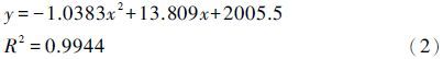
公式(2)中y为沉积物年龄,x为深度,R2=0.9944,达到显著性检验(F>95%),表明 210Pb和AMS 14C 测年可靠,无碳库效应,模式合理。该模式显示,岩芯顶部(即0cm)年龄为2006A.D.,而其实际年龄(采样时间)为2013A.D.,这可能是岩芯表层的混合作用所造成的。据模式外推至底部50cm处的年龄为100A.D.,从而建立了羊湖过去近2000年以来湖泊沉积的时间序列。另外,流域内临近湖泊普莫雍错沉积物50cm处对应年代为1600-2000cal.a B.P.[74, 78],也检验了本文年代的可靠性。
3.4 湖泊沉积物粒度的气候意义 3.4.1 敏感粒级湖泊沉积物颗粒粒径的大小直接反映了沉积水动力的状况[81, 82]。在较长时间尺度(千年、 百年)上,其粗细变化能反映湖面的扩张和收缩,进而可指示湖区气候的干湿变迁[83],即:“细粒沉积物增加粗粒减少,指示水位较高,气候湿润; 细粒减少粗粒增加,指示水位较低,气候干旱”[83, 84, 85]。也有研究认为在短时间尺度(十年、 年际)中,湖泊水位短时期内不可能出现太大变化,流域降雨量则是关键因素,降雨量大的湿润年份,沉积物粒度相对更粗[86]。
由于沉积环境的复杂性,平均粒径只能反映影响沉积物的多个动力条件的平均水平,因而其环境指示意义可能十分有限。为了更加有效的反演湖泊沉积环境,提取粒度敏感组分至关重要[87]。目前常用的提取方法有粒级-标准偏差法[88]、 主成分分析法[89]、 端元法[90]、 Weibull函数法[91]等。其中,粒级-标准偏差法因其能够直观的反映各粒级离散程度,操作过程容易实现而得以广泛运用,故本文使用粒级-标准偏差法提取粒度敏感组分。首先,对粒度数据0-2000μm按等对数间距划分出100个等级; 其次,对每个粒级下的所有百分含量求标准偏差,并绘制粒级-标准偏差图(图3A)。上述步骤均在Mastersizer 2000软件中完成。图3A中标准偏差峰值对应的粒级为对环境变化最为敏感的组分,即7-10μm、 58-83μm和462-666μm为羊湖岩芯的敏感粒级指标。

|
图3 羊湖粒级-标准偏差图(A)和沉积物粒度频率曲线特征(B) 在(B)中,1)-4)为悬浮组分,5)为跳跃组分,6)为滚动组分; a-d为粒度频率曲线,其中a和b代表深水环境,c代表浅水环境,d代表湖滨环境 Fig.3 Maps of grain size-standard deviation(A)and characteristics of grain size frequency curves(B)of sediments in Yamzhog Yumco Lake. In(B),1)-4)suspending component,5)satiating component,6)rolling component; a-d: grain-size frequency curves (a and b represent deep water environment; c represents shallow water environment; d represents lake shore environment) |
采样点附近的白地水文站(图1)为西藏羊湖流域唯一专门观测湖泊水位变化的国家基本站,该站自1974年至今有较完整的水位观测资料[33]。因湖泊粒度数据相对于水位数据分辨率低,故将湖泊水位变化数据进行5年滑动平均后,与7-10μm粒径的百分含量序列进行相关分析,两者呈现较好的正相关性(r=0.66)(图4),说明湖泊沉积中7-10μm粒径的百分含量变化基本能够指示湖泊水位的变化。

|
图4 羊湖7-10μm粒径百分含量与1974年以来白地水文站湖泊年平均水位的对比分析 Fig.4 Comparison of 7-10μm(%)in Yamzhog Yumco Lake core and average lake water level in Baidi Hydrometric Station since 1974 |
羊湖沉积物粒度一般由6个组分叠加构成,中值粒径范围分别为1)<1μm、 2)1-10μm、 3)10-70μm、 4)70-150μm、 5)150-700μm和6)>700μm,其中前4组属于悬浮组分、 5)为跳跃组分和6)为滚动组分(图3B)。粗粒组分含量越高,指示沉积物越靠近湖滨; 细粒组分含量越高,指示沉积物越靠近湖心[92]。而频率曲线的峰态则反映了沉积作用环境的变化[87]。羊湖沉积物的粒度频率曲线(见图3B中a-d)显示:a、 b两条粒度频率曲线有一个单峰和一个次弱峰,峰值出现在中细颗粒区,可能代表较为稳定的深水环境; c粒度频率曲线有2-3个较弱峰,峰值主要出现在中粗颗粒区,可能代表较为复杂的浅水环境; d频率曲线为一个单峰,位于粗颗粒区,可能代表湖滨环境。
3.4.3 粒度参数此外,本研究还计算了标准偏差、 偏度和峰态。标准偏差反映沉积物颗粒的分选程度,标准偏差数值越大,分选程度越差; 偏度表示频率曲线的对称性,即与正态分布曲线相比时,频率曲线主峰的位置,反映沉积物中粗细颗粒占有的比例; 峰态是与正态频率曲线相比时,曲线的尖锐或钝圆程度,反映了颗粒粒径分布的集中程度[93, 94]。
4 结果 4.1 羊湖沉积物粒度特征根据羊湖岩芯样品的粒度频率曲线和粒度参数的特征,并基于以上对粒度古环境意义的分析,将羊湖过去近2000年以来的沉积序列分为4个阶段(图5和图6)。

|
图5 羊湖沉积物粒度分布 Fig.5 Grain size distribution of sediments in Yamzhog Yumco Lake core |

|
图6 羊湖岩芯粒度敏感粒级和参数曲线(虚线为平均值) Fig.6 Curves of grain size sensitive grades and parameters of Yamzhog Yumco Lake core(the dotted line is average value) |
阶段1(50-40cm,约为100-820A.D.): 细粒组分(7-10μm下同)含量较高,而较粗组分(58-83μm下同)含量相对较低。可分为3个亚阶段: 亚阶段1-1(50-45cm,约100-480A.D.)和亚阶段1-3(42-40cm,约650-820A.D.)细粒组分含量较高,粗粒相对较低,偏度较低,指示了湖泊水位较高,环境相对稳定; 亚阶段1-2(45-42cm,约480-650A.D.)细粒组分下降,较粗组分增加,偏度增加,说明这段时期湖泊水位下降,可能为浅水-深水过渡环境。
阶段2(40-34cm,约为820-1200A.D.): 此阶段细粒组分含量较低,而较粗组分为整个岩芯的最高值段,较低的分选系数指示水动力条件较弱,较高的偏度指示粒径的分布不均匀,绝大多数样品的频率曲线出现2-3个较弱的峰,说明了此阶段湖泊为浅水环境。
阶段3(34-13cm,约为1200-1910A.D.): 细粒组分含量增加而较粗组分下降,表明此阶段湖泊水位升高,但波动剧烈,其中34-32cm(约1200-1320A.D.)、 31-28cm(约1400-1550A.D.)和22-17cm(约1780-1900A.D.) 细粒组分含量较高,较粗组分较低,频率曲线、 分选系数和偏度等也都反映这3个时期湖泊可能扩张,湖水较深。
阶段4(13-0cm,约为1910A.D. 至今):20世纪以来,细粒和较粗组分含量均急剧下降,粗粒组分(462-666μm)急剧增加,分选系数、 偏度和峰态急剧增加,均指示湖泊水位急剧下降。频率曲线则指示出此阶段由浅水向湖滨环境发展的过程。
4.2 过去近2000年来湖泊沉积粒度记录的干湿变化特征基于 210Pb和AMS 14C 测年构建的年代框架,利用粒度代用指标重建了青藏高原南部羊湖过去近2000年以来的干湿变化过程:1)100-820A.D.,湖泊水位和有效湿度较高,但沉积环境不稳定; 2)820-1200A.D.,湖泊水位较低,流域气候干旱或有效湿度较低; 3)1200-1910A.D.,湖泊水位升高,其中分别在约1200-1320A.D.、 1400-1550A.D. 和1780-1900A.D. 前后出现3次有效湿度增加和湖泊扩张时期; 4)1910A.D. 至今,湖泊急剧收缩,流域趋于干旱。
5 讨论 5.1 区域对比最新的北半球温度变化序列显示,1-300A.D. 较温暖,称为罗马暖期(RWP); 300-800A.D. 冷暖相间,但总体偏冷,称为黑暗时代冷期(DACP); 800-1300A.D. 温暖,为中世纪暖期(MWP); 1300-1900A.D. 寒冷,为小冰期(LIA); 1900A.D. 以后再次转为温暖,即20世纪暖期(CWP)[95]。
羊湖粒度记录的过去近2000年来干湿变化过程与北半球温度变化历史的对比表明(图7),黑暗时代冷期(100-820A.D.),羊湖粒度记录的湖泊处于高水位时期,有效湿度较高。这一时期的湿润气候在青藏高原其他地区也有报道,如高原西部松西错[96]和东北部柴达木盆地尼亚剖面[97]的孢粉记录显示,该时期蒿(Artemisia)/藜(Chenopodiaceae)比值(A/C)较高,指示气候相对湿润; 青海湖[23]、 苦海[24]和库赛湖[93]等湖泊面积扩大,流域生产力显著增加。中国西北干旱区的冰芯、 树轮、 河湖相沉积、 湖岸阶地、 古土壤以及文献资料等记录的综合研究[98]显示两汉时期(206BC-220A.D.)气候湿润,一些古文明如楼兰、 尼雅和克里雅文明均在该时期兴起或繁盛; 玛纳斯湖[99]、 巴里坤湖[100]、 博斯腾湖[101]等干旱区湖泊在该期也基本处于高湖面阶段,有效湿度较高。尽管起止年代存在差异以及不同代用指标可能会带来不确定性,但青藏高原及其周边地区整体显示出温凉偏湿的气候特征[9, 10, 14, 93]; 欧洲记录也显示出约400-900A.D. 期间,欧洲冰川前进,湖泊水位上升,是一个气候冷湿期[102]。另外,羊湖粒度记录的约480-620A.D. 的气候干旱与古里雅冰芯冰川累积量的降低基本一致(图7c)[20]。

|
图7 羊湖粒度记录与其他古气候记录的对比 (a)偏度(Sk);(b)7-10μm粒级百分含量(7-10μm/%);(c)古里雅冰芯冰川累积量(Ice accumulation rate of Guliya ice core)[20]; (d)太阳辐射强度(Intensity of solar radiation)[116];(e)北半球温度(Northern Hemisphere temperature)[95];(f)董哥洞石笋 δ18O(Dongge cave speleothem δ18O)[118];(g)万象洞石笋 δ18O(Wanxiang cave speleothem δ18O)[6] Fig.7 Comparison of grain size records of Yamzhog Yumco Lake and other paleoclimate records |
多年来,中世纪暖期和小冰期被学者们广泛关注[12, 13, 15, 103]。羊湖粒度记录显示820-1200A.D. 期间(对应中世纪暖期)湖泊水位较低,气候干旱。青藏高原其他地区的气候记录也揭示出该时期气候干旱: 如较低的古里雅冰芯冰川积累量表明当时有效湿度较低[20](图7c); 青海湖岩芯有机质和碳酸盐记录揭示出1160-1290A.D. 为明显的暖干期[104]。在中国东部季风区,湖光岩玛珥湖记录显示880-1260A.D. 为干旱气候[105],历史文献记录[106]和湖泊水位变化[107]的研究也揭示出中世纪暖期气候干旱。此外,GRIP2冰芯[108]、 秘鲁的Quelccaya冰芯[109]、 俄罗斯Taimyr树轮[110]、 美国白山树轮[111]以及东非[112]和北非[113]等地区均记录了中世纪暖期气候干旱。
羊湖粒度记录的在1200-1910A.D. 期间较高的湖泊水位和有效湿度表明,羊湖地区在小冰期气候湿润且波动明显,在约1200-1320A.D.、 1400-1550A.D. 和1780-1900A.D. 为3次显著的湿润期,可能为小冰期的3次较寒冷阶段(图7)。古里雅冰芯冰川积累量的记录显示小冰期冰川积累量较高(图7c),有效湿度较高[20]。苦海湖[24]、 青海湖[104, 114]以及湖光岩玛珥湖[105]等记录中均发现小冰期气候湿润。小冰期期间有效湿度增加,在北美地区[111]和欧洲地区[115]也均有报道。此外,历史文献记录的气候信息分析也显示出,约在1250A.D. 左右,气候发生明显突变,其主要标志是降温增湿[14]。由此看来,中世纪暖期干旱和小冰期湿润的气候特征可能在全球广泛存在,只是程度和起止时间有所不同。
20世纪暖期(1910A.D.至今),北半球温度曲线显示温度剧增[95](图7e),羊湖粒度记录的湖泊水位也显著的持续下降。
5.2 区域气候变化可能的驱动机制全球温度变化的主要驱动因素是太阳辐射强度,近2000年来太阳活动变化[116]与羊湖干湿变化呈良好的对应关系(图7d和7a、 7b),两者结合基本上表现为暖干-冷湿组合,如黑暗时代冷期和小冰期的湿润,中世纪暖期和现代暖期的干旱,及小冰期中3个显著湿润期的较强降温[95]。
众多的研究结果显示,青藏高原东南部广泛受印度季风的影响[1, 18, 19, 117]。董哥洞石笋 δ18O被认为精准的记录了印度季风的变化[118],而万象洞石笋 δ18O则与东亚夏季风的变化息息相关[6]。羊湖粒度反映的干湿变化在大的阶段与董哥洞石笋 δ18O和古里雅冰芯冰川累积量的变化基本一致(图7f和7c),而与万象洞石笋 δ18O变化具有明显差异(图7g),也似乎再次支持了印度季风主导着青藏高原东南部的气候变化这一推测。值得注意的是:图7显示从800A.D. 开始,太阳辐射强度和北半球陆地温度同步呈波动性下降,而古里雅冰芯冰川累积量和羊湖有效湿度同步上升,这似乎说明温度也控制了区域有效湿度的变化,在高海拔的干旱/半干旱地区,通过温度影响的蒸发在区域有效湿度变化中的作用不可忽视,即温度升高使得蒸发加剧导致有效湿度降低,而温度下降使得蒸发减弱导致有效湿度上升,从而导致该区的气候水热配置出现暖干-冷湿特征。
本文的研究显示,青藏高原南部地区过去2000年来主要表现为暖干-冷湿的气候模式。但是,值得深入讨论的是,控制有效湿度变化的主导因素究竟是降水还是温度?正如前文所述,羊湖所处的青藏高原南部广泛受到印度季风的影响。当温度上升时,印度季风增强[119],为气候系统注入更多的水汽,进而促进了降水的增加,导致气候湿润,那么则应该遵循暖湿-冷干的水热组合模式。而本研究的重建结果却显示了暖干-冷湿的水热组合模式,说明太阳辐射引起的温度变化可能是有效湿度变化的关键因素。该模式也得到了干旱区过去2000年来众多湖泊记录的支持[9, 93, 104, 114]。而暖干-冷湿模式又具有典型的西风带气候特征[120, 121],是否还存在西风环流的影响?仍需要进一步深入的研究。
6 结论基于青藏高原南部羊湖50cm岩芯的 210Pb和AMS 14C 测年,建立了过去近2000年来的年代序列。该岩芯沉积物粒度敏感粒级与湖泊现代水文数据的对比研究显示,沉积物粒度能够较好的反映流域有效湿度的变化,其中细粒组分(7-10μm)的百分含量能够指示湖泊水位的变化。通过该湖沉积物粒度记录的湿度变化与太阳活动、 北半球温度和亚洲季风记录对比分析,初步认为:1)过去近2000年来青藏高原南部气候变化过程可划分为4个阶段: 黑暗时代冷期(100-820A.D.),沉积物粒度较细,湖泊水位和有效湿度较高; 中世纪暖期(820-1200A.D.),粒度变粗,湖泊水位下降,流域气候干旱或有效湿度较低; 小冰期(1200-1910A.D.),粒度变细,湖泊水位上升,有效湿度增加,气候湿润; 20世纪以来,湖泊急剧收缩,流域趋于干旱。2)羊湖粒度反映的近2000年来有效湿度的变化与青藏高原及其他地区的记录有较好的一致性,但程度和起止时间有所不同。3)青藏高原南部地区过去2000年来主要表现为暖干-冷湿的气候模式,这种模式可能主要受到太阳辐射强度的控制。
需要指出的是,我们的湿度重建指标较为单一,缺乏其他代用指标的佐证。如控制有效湿度变化的主导因素是温度还是降水,是否存在西风环流的影响,仍需要进一步深入的研究。
致谢 真诚感谢审稿专家对文章提出的宝贵修改意见和编辑部老师辛勤的编辑工作!美国BETA实验室、 中国科学院南京地理与湖泊研究所湖泊沉积与环境重点实验室分别协助完成AMS 14C 测年、 210Pb 与 137Cs 测年,杜世松、 蒿承志等同志协助完成野外工作,在此一并致谢。
| 1 | Thompson L G, Yao T D, Thompson M et al. A high-resolution millennial record of the South Asian monsoon from Himalayan ice cores. Science, 2000, 289(5486):1916-1919 |
| 2 | 姚檀栋, 秦大河, 田立德等. 青藏高原2ka来温度与降水变化——古里雅冰芯记录. 中国科学(D辑), 1996, 26(4):348~353 Yao Tandong, Qin Dahe, Tian Lide et al. Variations of temperature and precipitation in Qing-Zang Plateau since 2ka(records of Guliya ice core). Science in China(Series D), 1996, 26(4):348~353 |
| 3 | 赵华标, 徐柏青, 王宁练. 青藏高原冰芯稳定氧同位素记录的温度代用性研究. 第四纪研究, 2014, 34(6):1215~1226 Zhao Huabiao, Xu Baiqing, Wang Ninglian. Study on the water stable isotopes in Tibetan Plateau ice cores as a proxy of temperature. Quaternary Sciences, 2014, 34(6):1215~1226 |
| 4 | Yang B, Brauning A, Shi Y F. Late Holocene temperature fluctuations on the Tibetan Plateau. Quaternary Science Reviews, 2003, 22(21-22):2335-2344 |
| 5 | Liu Yu, An Zhisheng, Linderholm H W et al. Annual temperatures during the last 2485 years in the mid-eastern Tibetan Plateau inferred from tree rings. Science in China(Series D), 2009, 52(3):348-359 |
| 6 | Zhang P Z, Cheng H, Edwards R L et al. A test of climate, sun, and culture relationships from an 1810-year Chinese cave record. Science, 2008, 322(5903):940-942 |
| 7 | Martin F, Miryam B-M, Karin H et al. Speleothem evidence for Late Holocene climate variability and floods in Southern Greece. Quaternary Research, 2014, 81(2):213-227 |
| 8 | 姜雅娟, 王维, 马玉贞等. 内蒙古鄂尔多斯高原泊江海子全新世气候变化初步研究. 第四纪研究, 2014, 34(3):654~665 Jiang Yajuan, Wang Wei, Ma Yuzhen et al. A preliminary study on Holocene climate change of Ordos Plateau, as inferred by sedimentary record from Bojianghaizi Lake of Inner Mongolia, China. Quaternary Sciences, 2014, 34(3):654~665 |
| 9 | 强明瑞, 陈发虎, 张家武等. 2ka来苏干湖沉积碳酸盐稳定同位素记录的气候变化. 科学通报, 2005, 50(13):1385~1393 Qiang Mingrui, Chen Fahu, Zhang Jiawu et al. Climatic changes documented by stable isotopes of sedimentary carbonate in Lake Sugan, northeastern Tibetan Plateau of China since 2ka BP. Chinese Science Bulletin, 2005, 50(13):1385~1393 |
| 10 | Zhong W, Xue J B, Ouyang J et al. Evidence of Late Holocene climate variability in the western Nanling Mountains, South China. Journal of Paleolimnology, 2014, 52(1-2):1-10 |
| 11 | 张丕远, 葛全胜, 张时煌等. 2000年来我国旱涝气候演化的阶段性和突变. 第四纪研究, 1997,(1):12~20 Zhang Piyuan, Ge Quansheng, Zhang Shihuang et al. The modes and abrupt changes of climate in China during recent 2000 years. Quaternary Sciences, 1997,(1):12~20 |
| 12 | 郝志新, 葛全胜, 郑景云. 宋元时期中国西北东部的冷暖变化. 第四纪研究, 2009, 29(5):871~879 Hao Zhixin, Ge Quansheng, Zheng Jingyun. Temperature variations during the Song and Yuan dynasties(960-1368A.D.)in the eastern part of north West China. Quaternary Sciences, 2009, 29(5):871~879 |
| 13 | 满志敏, 杨煜达. 中世纪温暖期升温影响中国东部地区自然环境的文献证据. 第四纪研究, 2014, 34(6):1197~1203 Man Zhimin, Yang Yuda. The Medieval warming impacts on the natural environment in Eastern China as inferred from historical documents. Quaternary Sciences, 2014, 34(6):1197~1203 |
| 14 | 葛全胜, 刘健, 方修琦等. 过去2000年冷暖变化的基本特征与主要暖期. 地理学报, 2013, 68(5):579~592 Ge Quansheng, Liu Jian, Fang Xiuqi et al. General characteristics of temperature change and centennial warm periods during the past 2000 years. Acta Geographica Sinca, 2013, 68(5):579~592 |
| 15 | 史锋, 杨保, 赵森等. 全球过去千年典型暖期温度空间格局重建. 第四纪研究, 2014, 34(6):1125~1135 Shi Feng, Yang Bao, Zhao Sen et al. Spatial pattern reconstruction of typical centennial warm periods of global temperature over the past millennium. Quaternary Sciences, 2014, 34(6):1125~1135 |
| 16 | Nyberg J, Malmgren B A, Kuijpers A et al. A centennial-scale variability of tropical North Atlantic surface hydrography during the Late Holocene. Palaeogeography, Palaeoclimatology, Palaeoecology, 2002, 183(s1-2):25-41 |
| 17 | Bradley R S, Hughes M K, Diaz H F. Climate in Medieval time. Science, 2003, 302(5644):404-405 |
| 18 | Wang Y B, Liu X Q, Herzschuh U. Asynchronous evolution of the Indian and East Asian summer monsoon indicated by Holocene moisture patterns in monsoonal Central Asia. Earth Science Reviews, 2010, 103(3):135-153 |
| 19 | An Z S, Colman S M, Zhou W J et al. Interplay between the Westerlies and Asian monsoon recorded in Lake Qinghai sediments since 32ka. Scientific Reports, 2012, 2(8):1036-1036 |
| 20 | 姚檀栋. 古里雅冰芯近2000年来气候环境变化记录. 第四纪研究, 1997,(1):52~61 Yao Tandong. Climatic and environmental record in the past about 2000 years from the Guliya ice core. Quaternary Sciences, 1997,(1):52~61 |
| 21 | 邵雪梅, 梁尔源, 黄磊等. 柴达木盆地东北部过去1437a的降水变化重建. 气候变化研究进展, 2006, 2(3):122~126 Shao Xuemei, Liang Eryuan, Huang Lei et al. A reconstructed precipitation series over the past millennium in the northeastern Qaidam Basin. Advances in Climate Change Research, 2006, 2(3):122~126 |
| 22 | Yang B, Braeuning A, Johnson K R et al. General characteristics of temperature variation in China during the last two millennia. Geophysical Research Letters, 2002, 29(9):381-384 |
| 23 | Liu Z H, Henderson A C G, Huang Y. Alkenone-based reconstruction of Late-Holocene surface temperature and salinity changes in Lake Qinghai, China. Geophysical Research Letters, 2006, 33(13):370-386 |
| 24 | Liu X Q, Dong H L, Yang X D et al. Late Holocene forcing of the Asian winter and summer monsoon as evidenced by proxy records from the northern Qinghai-Tibetan Plateau. Earth & Planetary Science Letters, 2009, 280(1-4):276-284 |
| 25 | 刘亚生, 常凤琴, 张虎才等. 云南腾冲青海湖泊沉积物物化参数的特点、环境意义及末次冰消期以来气候环境变化. 第四纪研究, 2015, 35(4):922~933 Liu Yasheng, Chang Fengqin, Zhang Hucai et al. Environmental significance of physicochemical parameters of sediment and climate changes since the late glacial at Qinghai Lake of Tengchong County, Yunnan Province. Quaternary Sciences, 2015, 35(4):922~933 |
| 26 | 涂路遥, 周鑫, 刘毅等. 近海泥质沉积物敏感粒径作为冬季风强度指标的再研究:与器测数据的对比. 第四纪研究, 2015, 35(6):1393~1400 Tu Luyao, Zhou Xin, Liu Yi et al. Re-analysis of sensitive grain size of coastal muddy sediments as proxy of winter monsoon strength:Comparison with instrumental data. Quaternary Sciences, 2015, 35(6):1393~1400 |
| 27 | An Z S, Kukla G, Porter S C et al. Late Quaternary dust flow on the Chinese Loess Plateau. Catena, 1991, 18(2):125-132 |
| 28 | Ding Z L, Yu Z W, Rutter N W et al. Towards an orbital time scale for Chinese loess deposits. Quaternary Science Reviews, 1994, 13(1):39-70 |
| 29 | 姜韬, 曾志刚, 南青云等. 全新世以来冲绳海槽北部S9孔粒度变化特征及其古气候响应. 第四纪研究, 2015, 35(2):307~318 Jiang Tao, Zeng Zhigang, Nan Qingyun et al. The grain size characteristics of the core S9 sediments in the northern Okinawa Trough and their paleoclimate response since Holocene. Quaternary Sciences, 2015, 35(2):307~318 |
| 30 | 李渊, 强明瑞, 王刚刚等. 晚冰期以来共和盆地更尕海碎屑物质输入过程与气候变化. 第四纪研究, 2015, 35(1):160~171 Li Yuan, Qiang Mingrui, Wang Ganggang et al. Processes of exogenous detrital input to Genggahai Lake and climatic changes in the Gonghe basin since the late glacial. Quaternary Sciences, 2015, 35(1):160~171 |
| 31 | 除多, 普穷, 拉巴卓玛等. 近40a西藏羊卓雍错湖泊面积变化遥感分析. 湖泊科学, 2012, 24(3):494~502 Chu Duo, Pu Qiong, Laba Zhuoma et al. Remote sensing analysis on lake area variations of Yamzho Yumco in Tibetan Plateau over the past 40a. Journal of Lake Sciences, 2012, 24(3):494~502 |
| 32 | 刘天仇. 西藏羊卓雍错水位动态研究. 地理科学, 1995, 15(1):55~62 Liu Tianchou. Changes of Yamzho Lake water stage in Xizang. Scientia Geographica Sinica, 1995, 15(1):55~62 |
| 33 | 米玛次仁, 田立德, 文蓉等. 西藏羊卓雍错近期湖水水位变化及其原因分析. 水文, 2013, 33(2):64~69 Mima Ciren, Tian Lide, Wen Rong et al. Recent water level change of Yamzhog Yumco Lake, Tibet. Journal of China Hydrology, 2013, 33(2):64~69 |
| 34 | 孙瑞, 张雪芹, 吴艳红. 藏南羊卓雍错流域水化学主离子特征及其控制因素. 湖泊科学, 2012, 24(4):600~608 Sun Rui, Zhang Xueqin, Wu Yanhong. Major ion chemistry of water and its controlling factors in the Yamzhog Yumco basin, south Tibet. Journal of Lake Sciences, 2012, 24(4):600~608 |
| 35 | 张雪芹, 孙瑞, 朱立平. 藏南羊卓雍错流域主要湖泊水质状况及其评价. 冰川冻土, 2012, 34(4):950~958 Zhang Xueqin, Sun Rui, Zhu Liping. Lake water in the Yamzhog Yumco basin in south Tibetan region:Quality and evaluation. Journal of Glaciology and Geocryology, 2012, 34(4):950~958 |
| 36 | 孙瑞, 张雪芹, 郑度. 藏南羊卓雍错流域水化学区域差异及其成因. 地理学报, 2013, 68(1):36~44 Sun Rui, Zhang Xueqin, Zheng Du. Spatial variation and its causes of water chemical property in Yamzhog Yumco basin, south Tibet. Acta Geographica Sinica, 2013, 68(1):36~44 |
| 37 | 高晶, 姚檀栋, 田立德等. 羊卓雍错流域湖水氧稳定同位素空间分布特征. 冰川冻土, 2008, 30(2):338~343 Gao Jing, Yao Tandong, Tian Lide et al. The spacial distribution of oxygen stable isotope in the Yamzho Lake basin, Xizang(Tibet). Journal of Glaciology and Geocryology, 2008, 30(2):338~343 |
| 38 | 王苏民. 中国湖泊志. 北京:科学出版社, 1998. 1~494 Wang Sumin. Chronological Report for Lakes of China. Beijing:Science Press, 1998. 1~494 |
| 39 | 王乃文, 刘桂芳, 陈国铭. 西藏南部羊卓雍错区域地层研究. 青藏高原地质文集, 1983, 1(6):1~20 Wang Naiwen, Liu Guifang, Chen Guoming. Stratigraphic research of the Yamzhog Yumco region in southern Tibet. The Qinghai-Tibet Plateau Geological Corpus, 1983, 1(6):1~20 |
| 40 | 中国科学院青藏高原综合考察队. 西藏植被. 北京:科学出版社, 1988. 225~226 The Comprehensive Expedition of Qinghai-Tibet Plateau of the Chinese Academy of Sciences. The Vegetation of Tibet. Beijing:Science Press, 1988. 225~226 |
| 41 | Appleby P G, Oldfield F. The assessment of 210Pb data from sites with varying sediment accumulation rates. Hydrobiologia, 1983, 103(1):29-35 |
| 42 | 万国江. 137Cs及210Pbex方法湖泊沉积计年研究新进展. 地球科学进展, 1995, 10(2):188~192 Wan Guojiang. Progresses on 137Cs and 210Pbex dating of lake sediments. Advance in Earth Sciences, 1995, 10(2):188~192 |
| 43 | 万国江. 现代沉积的210Pb计年. 第四纪研究, 1997,(3):230~239 Wan Guojiang. 210Pb dating for recent sedimentation. Quaternary Sciences, 1997,(3):230~239 |
| 44 | McDermott F, Mattey D P, Hawkesworth C et al. Centennial-scale Holocene climate variability revealed by a high-resolution speleothem delta 18 O record from SW Ireland. Science, 2001, 294(5545):1328-1331 |
| 45 | Alonso-Hernandez C M, Diaz-Asencio M, Munoz-Caravaca A et al. Recent changes in sedimentation regime in Cienfuegos Bay, Cuba, as inferred from 210Pb and 137Cs vertical profiles. Continental Shelf Research, 2006, 26(2):153-167 |
| 46 | Appleby P G, Nolan P J, Gifford D W et al.210Pb dating by low background gamma counting. Hydrobiologia, 1986, 143(1):21-27 |
| 47 | Begy R, Cosma C, Timar A. Recent changes in Red Lake(Romania)sedimentation rate determined from depth profiles of 210Pb and 137Cs radioisotopes. Journal of Environmental Radioactivity, 2009, 100(8):644-648 |
| 48 | Mccall P L, Robbins J A, Matisoff G. 137Cs and 210Pb transport and geochronologies in urbanized reservoirs with rapidly increasing sedimentation rates. Chemical Geology, 1984, 44(84):33-65 |
| 49 | 张信宝, 龙翼, 文安邦等. 中国湖泊沉积物 137Cs和 210Pbex断代的一些问题. 第四纪研究, 2012, 32(3):430~440 Zhang Xinbao, Long Yi, Wen Anbang et al. Discussion on applying 137Cs and 210Pbex for lake sediment dating in China. Quaternary Sciences, 2012, 32(3):430~440 |
| 50 | 万国江, 黄荣贵, 王长生等. 红枫湖沉积物顶部 210Pbex垂直剖面的变异. 科学通报, 1990,(8):612~615 Wan Guojiang, Huang Ronggui, Wang Changsheng et al. A variance of vertical profile for 210Pbex at the top of sediment in Hong Feng Lake. Chinese Science Bulletin, 1990,(8):612~615 |
| 51 | 夏小明, 谢钦春, 李炎等. 东海沿岸海底沉积物中的 137Cs、210Pb分布及其沉积环境解释. 东海海洋, 1999, 17(1):20~27 Xia Xiaoming, Xie Qinchun, Li Yan et al.137Cs and 210Pb profiles of the seabed cores along the East China Sea and their implications to sedimentary environment. Dong Hai Marine Science, 1999, 17(1):20~27 |
| 52 | 储国强, 顾兆炎, 许冰等. 东北四海龙湾玛珥湖沉积物纹层计年与 137Cs、210Pb测年. 第四纪研究, 2005, 25(2):202~207 Chu Guoqiang, Gu Zhaoyan, Xu Bing et al. Varvechronology and radiometric dating(137Cs, 210Pb)from the Sihailongwan Maar, Northeastern China. Quaternary Sciences, 2005, 25(2):202~207 |
| 53 | 陈诗越, 王苏民, 陈影影等. 东平湖沉积物 210Pb、137Cs垂直分布及年代学意义. 第四纪研究, 2009, 29(5):981~987 Chen Shiyue, Wang Sumin, Chen Yingying et al. Vertical distribution and chronological implication of 137Cs and 210Pb in sediment of Dongping Lake, Shandong Province. Quaternary Sciences, 2009, 29(5):981~987 |
| 54 | 金爱春, 蒋庆丰, 陈晔等. 新疆乌伦古湖的 210Pb、137Cs测年与现代沉积速率. 现代地质, 2010, 24(2):377~382 Jin Aichun, Jiang Qingfeng, Chen Hua et al.210Pb and 137Cs dating and modern sedimentation rate in the Wulungu Lake, Xinjiang. Geoscience, 2010, 24(2):377~382 |
| 55 | 柴社立, 高丽娜, 邱殿明等. 吉林省西部月亮湖沉积物的 210Pb和 137Cs测年及沉积速率. 吉林大学学报:地球科学版, 2013, 43(1):134~141 Chai Sheli, Gao Lina, Qiu Dianming et al.210Pb and 137Cs dating of the sediment core and its recent accumulation rates in Yueliang Lake in west Jilin Province. Journal of Jilin University(Earth Science Edition), 2013, 43(1):134~141 |
| 56 | Imboden D M, Mariana S. The influence of radon diffusion on the 210Pb distribution in sediments. Journal of Geophysical Research Oceans, 1982, 87(C1):557-565 |
| 57 | Benoit G, Rozan T F. 210Pb and 137Cs dating methods in lakes:A retrospective study. Journal of Paleolimnology, 2001, 25(4):455-465 |
| 58 | Yutaka K. Characterization of 210Pb and 137Cs radionuclides in sediment from Lake Shinji, Shimane Prefecture, western Japan. Applied Radiation & Isotopes Including Data Instrumentation & Methods for Use in Agriculture Industry & Medicine, 2011, 69(2):455-462 |
| 59 | Chen Fahu, Huang Xiaozhong, Zhang Jiawu et al. Humid Little Ice Age in arid Central Asia documented by Bosten Lake, Xinjiang, China. Science in China(Series D), 2006, 49(12):1280-1290 |
| 60 | 金和天, 潘岩, 杨颖亮等. 浙江余姚田螺山遗址土壤植硅\{AMS 14 C\} 测年初步研究. 第四纪研究, 2014, 34(1):1~7 Jin Hetian, Pan Yan, Yang Yingliang et al. Primary study on \{AMS 14 C\} dating of phytolith at Tianluoshan site, Zhejiang Province. Quaternary Sciences, 2014, 34(1):1~7 |
| 61 | 彭环环, 郑卓, 郑艳伟等. 肇庆高要泥炭沉积揭示的全新世植被演变及人类活动历史. 第四纪研究, 2015, 35(3):742~754 Peng Huanhuan, Zhen Zhuo, Zheng Yanwei et al. Holocene vegetation changes and human activities revealed by a peat sediment core in Gaoyao, Zhaoqing. Quaternary Sciences, 2015, 35(3):742~754 |
| 62 | 任雅琴, 王彩红, 李瑞博等. 有机质饱和烃和δ13Corg. 记录的博斯腾湖早全新世晚期以来生态环境演变. 第四纪研究, 2014, 34(2):425~433 Ren Yaqin, Wang Caihong, Li Ruibo et al. Ecological environment change recorded by sediment n-alkane and δ13Corg. of Lake Bosten since late of Early Holocene. Quaternary Sciences, 2014, 34(2):425~433 |
| 63 | 孙伟伟, 沈吉, 张恩楼等. 日本大沼湖沉积物碳氮比值、有机碳同位素特征及其近400年的古气候环境意义. 第四纪研究, 2014, 34(6):1306~1313 Sun Weiwei, Shen Ji, Zhang Enlou et al. Characteristics of organic stable carbon isotope and C/N ration of sediments in Lake Onuma, Japan and their environmental implicationd for the last 400 years. Quaternary Sciences, 2014, 34(6):1306~1313 |
| 64 | 聂森艳, 王汝建, 肖文申. 南极半岛Bransfield海峡约6000年以来的陆源组分记录及其古环境意义. 第四纪研究, 2014, 34(3):590~599 Nie Senyan, Wang Rujian, Xiao Wenshen. A 6000-year record of terrigeneous components from the Bransfield Strait, Antarctic Peninsula:Responses to climate change. Quaternary Sciences, 2014, 34(3):590~599 |
| 65 | 范佳伟, 肖举乐, 温锐林等. 内蒙古达里湖全新世有机碳氮同位素记录与环境演变. 第四纪研究, 2015, 35(4):856~870 Fan Jiawei, Xiao Jule, Wen Ruilin et al. Holocene environment variations recorded by stable carbon and nitrogen isotopes of sedimentary organic matter from Dali Lake in Inner Mongolia. Quaternary Sciences, 35(4):856~870 |
| 66 | 李冬玲, 蒋辉, 徐晓群等. 南冲绳海槽沉积物中淡水硅藻的发现及1000年以来台风降雨的重建. 第四纪研究, 2015, 35(3):755~766 Li Dongling, Jiang Hui, Xu Xiaoqun et al. Freshwater diatoms in the southern Okinawa Trough and its implication to typhoon precipitation during the last millennium. Quaternary Sciences, 2015, 35(3):755~766 |
| 67 | Abbott M B, Stafford T W. Radiocarbon geochemistry of modern and ancient arctic lake systems, Baffin Island, Canada. Quaternary Research, 1996, 45(3):300-311 |
| 68 | Moreton S G, Rosqvist G C. Radiocarbon reservoir ages from freshwater lakes, South Georgia, Sub-Antarctic:Modern analogues from particulate organic matter and surface sediments. Radiocarbon, 2004, 46(2):621-626 |
| 69 | Morrill C, Overpeck J T, Cole J E et al. Holocene variations in the Asian monsoon inferred from the geochemistry of lake sediments in central Tibet. Quaternary Research, 2006, 65(2):232-243 |
| 70 | Watanabe T, Nakamura T, Watanabe N et al. High-time resolution \{AMS 14 C\} data sets for Lake Baikal and Lake Hovsgol sediment cores:Changes in radiocarbon age and sedimentation rates during the transition from the last glacial to the Holocene. Quaternary International, 2009, 205(1):12-20 |
| 71 | Doran P T, Berger G W, Lyons W B et al. Dating Quaternary lacustrine sediments in the McMurdo Dry Valleys, Antarctica. Palaeogeography, Palaeoclimatology, Palaeoecology, 1999, 147(s3-4):223-239 |
| 72 | Hall B L, Henderson M. Use of uranium-thorium dating to determine past 14C reservoir effects in lakes:Examples from Antarctica. Earth and Planetary Science Letters, 2001, 193(3-4):565-577 |
| 73 | 吴艳宏, 王苏民, 周力平等. 岱海14C测年的现代碳库效应研究. 第四纪研究, 2007, 27(4):507~510 Wu Yanhong, Wang Sumin, Zhou Liping et al. Modern reservoir age for 14C dating in Daihai Lake. Quaternary Sciences, 2007, 27(4):507~510 |
| 74 | Watanabe T, Nakamura T, Matsunaka T et al. A chronology of the PY608E-PC sediment core(Lake Pumoyum Co, southern Tibetan Plateau)based on radiocarbon dating of total organic carbon. Nuclear Instruments & Methods in Physics Research, 2013, 294(6):520-523 |
| 75 | 侯居峙, William J D'Andrea, 柳中晖. 湖泊碳库效应对青藏高原气候变化解释的影响探讨. 第四纪研究, 2012, 32(3):441~453 Hou Juzhi, William J D'Andrea, Liu Zhonghui. Geochronological limitations for interpreting the paleoclimatic history of the Tibetan Plateau. Quaternary Sciences, 2012, 32(3):441~453 |
| 76 | Stein M, Migowski C, Bookman R et al. Temporal changes in radiocarbon reservoir age in the Dead Sea-Lake Lisan system. Radiocarbon, 2004, 46(2):649-656 |
| 77 | Hendy C H, Hall B L. The radiocarbon reservoir effect in proglacial lakes:Examples from Antarctica. Earth & Planetary Science Letters, 2006, 241(s3-4):413-421 |
| 78 | Watanabe T, Matsunaka T, Nakamura T et al. A new 14C data set of the PY608W-PC sediment core from Lake Pumoyum Co(southeastern Tibetan Plateau)over the last 19 kyr. Radiocarbon, 2010, 52(3):1435-1442 |
| 79 | 李占玲, 徐宗学, 巩同梁. 雅鲁藏布江流域径流特性变化分析. 地理研究, 2008, 27(2):353~361 Li Zhanling, Xu Zongxue, Gong Tongliang. Characteristics of runoff variation in the Yarlung Zangbo River basin. Geographical Research, 2008, 27(2):353~361 |
| 80 | Reimer P J, Bard E, Bayliss A et al. Intcal13 and Marine13 radiocarbon age calibration curves 0-50,000 years cal BP. Radiocarbon, 2013, 55(4):1869-1887 |
| 81 | 谢又予. 沉积地貌分析. 北京:海洋出版社, 2000. 30~33 Xie Youyu. The Analysis of Sedimentary Physiognomy. Beijing:China Ocean Press, 2000. 30~33 |
| 82 | 王君波, 朱立平. 藏南沉错沉积物的粒度特征及其古环境意义. 地理科学进展, 2002, 21(5):459~467 Wang Junbo, Zhu Liping. Grain-size characteristics and their paleo-environmental significance of Chen Co Lake sediments in southern Tibet. Progress in Geography, 2002, 21(5):459~467 |
| 83 | 陈敬安, 万国江, 张峰等. 不同时间尺度下的湖泊沉积物环境记录——以沉积物粒度为例. 中国科学(D辑), 2003, 33(6):563~568 Chen Jing'an, Wan Guojiang, Zhang Feng et al. Lake sediment environmental records under different time scale——Case on sediment particle size. Science in China(Series D), 2003, 33(6):563~568 |
| 84 | 何华春, 丁海燕, 张振克等. 淮河中下游洪泽湖湖泊沉积物粒度特征及其沉积环境意义. 地理科学, 2005, 25(5):590~596 He Huachun, Ding Haiyan, Zhang Zhenke et al. Grain-size characteristics and their environmental significance of Hongze Lake sediments. Scientia Geographica Sinica, 2005, 25(5):590~596 |
| 85 | Wang H Y, Liu H Y, Cui H T et al. Terminal Pleistocene/Holocene palaeoenvironmental changes revealed by mineral-magnetism measurements of lake sediments for Dali Nor area, southeastern Inner Mongolia Plateau, China. Palaeogeography, Palaeoclimatology, Palaeoecology, 2001, 170(1):115-132 |
| 86 | 刘兴起, 王苏民, 沈吉. 青海湖QH-2000钻孔沉积物粒度组成的古气候古环境意义. 湖泊科学, 2003, 15(2):112~117 Liu Xingqi, Wang Sumin, Shen Ji. The grain size of the core QH-2000 in Qinghai Lake and its implication for paleoclimate and paleoenvironment. Journal of Lake Sciences, 2003, 15(2):112~117 |
| 87 | 孙千里, 周杰, 肖举乐. 岱海沉积物粒度特征及其古环境意义. 海洋地质与第四纪地质, 2001, 21(1):93~95 Sun Qianli, Zhou Jie, Xiao Jule. Grain-size characteristics of Lake Daihai sediments and its palaeoenvironment significance. Marine Geology & Quaternary Geology, 2001, 21(1):93~95 |
| 88 | Boulay S, Colin C, Trentesaux A et al. Mineralogy and sedimentology of Pleistocene sediment in the South China Sea(ODP Site 1144). Proceedings of the Ocean Drilling Program, 2002, 184(1):1-21 |
| 89 | 汪海斌, 陈发虎, 张家武. 黄土高原西部地区黄土粒度的环境指示意义. 中国沙漠, 2002, 22(1):21~26 Wang Haibin, Chen Fahu, Zhang Jiawu. Environment significance of grain size of loess-paleosol sequence in western part of Chinese Loess Plateau. Journal of Desert Research, 2002, 22(1):21~26 |
| 90 | Prins M A, Postma G, Cleveringa J. Controls on terrigenous sediment supply to the Arabian Sea during the Late Quaternary:The Makran continental slope. Marine Geology, 2000, 169(3):351-371 |
| 91 | 孙东怀, 安芷生, 苏瑞侠等. 古环境中沉积物粒度组分分离的数学方法及应用. 自然科学进展, 2001, 11(3):269~276 Sun Donghuai, An Zhisheng, Su Ruixia et al. The mathematical method and its application of partitioning grain-size distribution from the sedimentary components in paleoenvironment. Progress of Natural Sciences, 2001, 11(3):269~276 |
| 92 | 殷志强, 秦小光, 吴金水等. 湖泊沉积物粒度多组分特征及其成因机制研究. 第四纪研究, 2008, 28(2):345~353 Yin Zhiqiang, Qin Xiaoguang, Wu Jinshui et al. Multimodal grain-size distribution characteristics and formation mechanism of lake sediments. Quaternary Sciences, 2008, 28(2):345~353 |
| 93 | 王永波, 刘兴起, 羊向东等. 可可西里库赛湖揭示的青藏高原北部近4000年来的干湿变化. 湖泊科学, 2008, 20(5):605~612 Wang Yongbo, Liu Xingqi, Yang Xiangdong et al. A 4000-year moisture evolution recorded by sediments of Lake Kusai in the Hoh Xil area, northern Tibetan Plateau. Journal of Lake Sciences, 2008, 20(5):605~612 |
| 94 | 刘世昊, 丰爱平, 李培英等. 现代黄河三角洲地区晚更新世以来高分辨率沉积粒度特征及动力沉积环境演化. 第四纪研究, 2015, 35(2):291~306 Liu Shihao, Feng Aiping, Li Peiying et al. High-resolution grain size distribution and evolution of the sediment-dynamic environment in the modern Yellow River delta since the Latest Pleistocene. Quaternary Sciences, 2015, 35(2):291~306 |
| 95 | Ljungqvist F C. A new reconstruction of temperature variability in the extra-tropical Northern Hemisphere during the last two millennia. Swedish Society for Anthropology and Geography, 2010, 92(3):339-351 |
| 96 | Van Campo E, Cour P, Huang C X. Holocene environmental changes in Bangong Co basin(western Tibet). Part 2:The pollen record. Palaeogeography, Palaeoclimatology, Palaeoecology, 1996, 120(1):49-63 |
| 97 | Zhong W, Shu Q, Xiong H G. Pollen assemblages of Niya section in southern Xinjiang and paleoenvironmental evolution. Geographical Research, 2001, 20(1):91-96 |
| 98 | Yang B, Braeuning A, Shi Y F et al. Evidence for a Late Holocene warm and humid climate period and environmental characteristics in the arid zones of Northwest China during 2.2 similar to 1.8 kyr BP. Journal of Geophysical Research Atmospheres, 2004, 109(2):1-10 |
| 99 | Rhodes T E, Gasse F, Lin R et al. A Late Pleistocene-Holocene lacustrine record from Lake Manas, Zunggar(northern Xinjiang, Western China). Palaeogeography, Palaeoclimatology, Palaeoecology, 1996, 120(1):105-121 |
| 100 | 薛积彬, 钟巍. 新疆巴里坤湖全新世气候环境变化与高低纬间气候变化的关联. 中国科学:地球科学, 2011, 41(1):61~73 Xue Jibin, Zhong Wei. Holocene climate variation denoted by Barkol Lake sediments in northeastern Xinjiang and its possible linkage to the high and low latitude climates. Science China:Earth Science, 2011, 41(1):61~73 |
| 101 | 陈发虎, 黄小忠, 杨美临等. 亚洲中部干旱区全新世气候变化的西风模式——以新疆博斯腾湖记录为例. 第四纪研究, 2006, 26(6):881~887 Chen Fahu, Huang Xiaozhong, Yang Meilin et al. Westerly dominated Holocene climate model in arid Central Asia——Case study on Bosten Lake, Xinjiang, China. Quaternary Sciences, 2006, 26(6):881~887 |
| 102 | Holzhauser H, Magny M, Zumbuühl H J. Glacier and lake-level variations in west-Central Europe over the last 3500 years. The Holocene, 2005, 15(6):789-801 |
| 103 | 张小艳, 周亚利, 庞奖励等. 光释光测年揭示浑善达克沙地中世纪暖期和小冰期环境变迁与人类活动的关系. 第四纪研究, 2012, 32(3):535~546 Zhang Xiaoyan, Zhou Yali, Pang Jiangli et al. The relationship between environmental changes and human activities during the Medieval Warm Period and the Little Ice Age in Otindag sand land by OSL dating. Quaternary Sciences, 2012, 32(3):535~546 |
| 104 | 沈吉, 张恩楼, 夏威岚. 青海湖近千年来气候环境变化的湖泊沉积记录. 第四纪研究, 2001, 21(6):508~513 Shen Ji, Zhang Enlou, Xia Weilan. Records from lake sediments of the Qinghai Lake to mirror climatic and environmental changes of the past about 1000 years. Quaternary Sciences, 2001, 21(6):508~513 |
| 105 | Chu G Q, Liu J, Sun Q et al. The'Mediaeval Warm Period'drought recorded in Lake Huguangyan, tropical South China. The Holocene, 2002, 12(5):511-516 |
| 106 | Gong G, Hameed S. The variation of moisture conditions in China during the last 2000 years. International Journal of Climatology, 1991, 11(3):271-283 |
| 107 | Fang J Q. Lake evolution during the last 3000 years in China and its implications for environmental change. Quaternary Research, 1993, 39(2):175-185 |
| 108 | Stuiver M, Grootes P M, Braziunas T F. The GISP2 18 O climate record of the past 16,500 years and the role of the sun, ocean and volcanoes. Quaternary Research, 1995, 44(3):341-354 |
| 109 | Thompson L G. Ice core evidence from Peru and China. London:Routledge, 1992. 517-548 |
| 110 | Briffa K R, Bartholin T S, Eckstein D et al. A 1400-year tree-ring record of summer temperatures in Fennoscandia. Nature, 1990, 346(6283):434-439 |
| 111 | LaMarche V C. Paleoclimatic inferences from long tree-ring records. Science, 1974, 183(4129):1043-1048 |
| 112 | Verschuren D, Laird K B, Cumming B F. Rainfall and drought in equatorial East Africa during the past 1,100 years. Nature, 2000, 403(6768):410-414 |
| 113 | Lamb H F, Gasse F, Bonkaddour A et al. Relation between century-scale Holocene arid intervals in tropical and temperate zones. Nature, 1995, 373(6510):134-137 |
| 114 | 张家武, 金明, 陈发虎等. 青海湖沉积岩芯记录的青藏高原东北部过去800年以来的降水变化. 科学通报, 2004, 49(1):10~14 Zhang Jiawu, Jin Ming, Chen Fahu et al. High-resolution precipitation variations in the northeast Tibetan Plateau over the last 800 years documented by sediment cores of Qinghai Lake. Chinese Science Bulletin, 2003, 48(14):1451~1456 |
| 115 | Jacobson A H. Lake-level fluctuations at Ljustjärnen, Central Sweden and their implications for the Holocene climate of Scandinavia. Palaeogeography, Palaeoclimatology, Palaeoecology, 1995, 118(3-4):269-290 |
| 116 | Stuiver M, Reimer P J, Bard E et al. INTCAL98 radiocarbon age calibration, 24,000-0cal BP. Radiocarbon, 1998, 40(3):1041-1083 |
| 117 | Wang B, Clemens S C, Liu P. Contrasting the Indian and East Asian monsoons:Implications on geologic timescales. Marine Geology, 2003, 201(1-3):5-21 |
| 118 | Dykoski C A, Edwards R L, Cheng H et al. A high-resolution, absolute-dated Holocene and deglacial Asian monsoon record from Dongge Cave, China. Earth and Planetary Science Letters, 2005, 233(s1-2):71-86 |
| 119 | Gupta A K, Anderson D M, Overpeck J T. Abrupt changes in the Asian southwest monsoon during the Holocene and their links to the North Atlantic Ocean. Nature, 2003, 421(6921):354-357 |
| 120 | Chen F H, Yu Z C, Yang M et al. Holocene moisture evolution in arid Central Asia and its out-of-phase relationship with Asian monsoon history. Quaternary Science Reviews, 2008, 27(3):351-364 |
| 121 | 李吉均. 中国西北地区晚更新世以来环境变迁模式. 第四纪研究, 1990,(3):197~204 Li Jijun. The patterns of environmental changes since Late Pleistocene in Northwestern China. Quaternary Sciences, 1990,(3):197~204 |
Abstract
The Tibetan Plateau is a sensitive region to climate changes controlled by interactions of large-scale atmospheric circulations, including the East Asian monsoon, Indian monsoon and mid-latitude westerlies.This paper presents a high-resolution humidly reconstruction over the past 2000 years from the sediment of Yamzhog Yumco Lake(28°27'~29°12'N, 90°08'~91°45'E; altitude in 4440m a.s.l.), a representative inland lake located at southern Tibetan Plateau, China.
A suite of 50cm-long cores(29°10'40"N,90°32'25"E; 4440m a.s.l.and 3.2m in depth) was drilled from the northwest part of the lake using Russian drill in 2013.The cores were mainly composed of clayey silt, intercalated with silt, with minor fine sand and medium-grained sand.50 grain-size samples were sampled at 1cm intervals.19 samples collected from the upper portion of the core were used in 210 Pb dating and two plant materials from the lower portion of the core were dated by AMS 14C dating method.
According to the analysis, an age-depth model was established by AMS 14C dating and 210 Pb measurements for the past 2000 years.The study on environmentally sensitive grain-size population and comparison with modern hydrologic data implied the clay fraction(7~10μm) percentage could be used as a proxy for lake-level change during the past 2000 years.Then, the humidity changes during the past 2000 years in the southern Tibetan Plateau have been reconstructed based on the grain-size recorded from Yamzhog Yumco Lake core, including the clay fraction(7~10μm) percentage, grain-size population, grain-size frequency curve and grain-size parameters.
The variation of humidity revealed by the reconstruction indicated that there were four periods during the last 2000 years.From 100 to 820A.D., the sediment sizes were finer, suggesting a relatively high lake level and effective moisture, and a moderately wet and cool period corresponding to the Dark Age Cold Period(DACP).Subsequently, a relatively low lake level and effective moisture prevailed between 820A.D.and 1200A.D., as inferred by the coarser sediment sizes.And a dry climate might have occurred in the studying area during the Medieval Warm Period(MWP).During 1200~1910A.D., the lake level rising and effective moisture increase under a wetting climate, those were reconstructed on the basis of the fining of sediment.The climate was wetter in this period, which could correspond to the Little Ice Age(LIA).Moreover, the wettest phases occurred on about 1200~1320A.D., 1400~1550A.D.and 1780~1900A.D., which might correspond to the three coldest phases of the Little Ice Age.Since the 20th century, the lake level quickly lowered and a dry climate prevailed in the studying area during the 20th century warm period(CWP).
Two views were obtained by comparison with the solar insolation, Northern Hemisphere temperature proxy and Asian monsoon index from other regions.(1) During the last 2000 years the humidity changes recorded by the grain-size in Yamzhog Yumco lake was in broad consistent with the records from the Tibetan Plateau and surrounding areas, but the amplitude and duration of regional phases were different.(2) The pattern of climate change in the southern Tibetan Plateau during the past 2000 years probably was warm-dry and cold-wet types, which might be in close relationship to the temperature and solar insolation.Moreover, the well dated, high-resolution grain-size record from lake sediments could remedy the lack of studies on moisture records in the southern Tibetan Plateau during the past 2000 years.Therefore, it is of great significance to better understand the mechanisms of the climate change in the high elevation of monsoon areas over the past two millennia.