印度板块与欧亚大陆距今约50 Ma以来的碰撞,造成了目前世界上面积最大、海拔最高的青藏高原(Molnar and Tapponnier, 1975;许志琴等,2006).大陆碰撞后,板块相互作用并未终止,印度板块仍以约50 mm·a-1的速率向北推进(Tapponnier et al., 1981).GPS观测数据显示,现今青藏高原内部沿NNE-SSW向仍在发生缩短变形(Zhang et al., 2004),重力观测结果表明青藏高原目前仍以8~10 mm·a-1的速率隆升(王勇等, 2004).
东昆仑山位于青藏高原的北部,平均海拔5000~6000 m,其北侧的柴达木盆地平均海拔仅约2700 m,南侧的可可西里地块平均海拔为约4600 m,三者高差明显.东昆仑—柴达木地块处于印度大陆北进与北部亚洲阿拉善地块向南挤压形成的大陆动力学背景区,东昆仑山和柴达木盆地之间悬殊的地形差异究竟是如何形成的,其深层原因一直困扰着广大的地质、地球物理学家(Clark and Royden, 2000; Yin et al., 2007).根据地表地质研究,Meyer等(1998)提出,柴达木盆地下面存在一条向南倾斜的低角度基底逆冲断裂,沿此断裂东昆仑山向北逆冲到了柴达木盆地之上,造成东昆仑地表剧烈隆升;Mock等(1999)也认为东昆仑山抬升的主要原因是其沿北昆仑逆冲断裂(隐伏,下同)向北逆冲到柴达木盆地之上;Tapponnier等(2001)秉持Meyer等(1998)的观点,认为东昆仑地壳增厚是东昆仑地壳向北向柴达木盆地仰冲的结果.然而,根据在青藏高原东部的地表地质观测以及实验室计算机数值模拟结果,另外一派学者却持有完全不同的观点,认为青藏高原内部平坦的地形及其在高原周边的地形起伏形态受地壳内部“通道流(Channel Flow)”及其流动性控制(Beaumont et al., 2004; Clark and Royden, 2000).天然地震波形资料显示,东昆仑山和柴达木盆地之间Moho存在明显的错断,东昆仑山隆升可能是在刚性柴达木岩石圈的垂直阻挡下,东昆仑地壳受到向北运动的可可西里地块强烈挤压的结果(Zhu and Helmberger, 1998).柴达木盆地东南缘的天然地震接收函数成像结果显示,东昆仑地壳增厚也可能是柴达木地壳向东昆仑上地壳仰冲的结果(Shi et al., 2009).
东昆仑山和柴达木盆地的海拔高差超过两千多米,表明两个块体的地壳厚度存在巨大的差异.高锐(1995)沿格尔木到拉萨公路的地学断面最早揭示柴达木盆地中部的南侧北昆仑逆冲断裂(隐伏)附近,莫霍面深度可能存在从约61 km到约52 km近10 km的突变.柴达木盆地东南缘天然地震远震P波双脉冲波至现象显示,在东昆仑、柴达木交界附近,莫霍面存在15~20 km的突变(Zhu and Helmberger, 1998).接收函数成像、背景噪声成像等研究进一步证实在两块体中部存在约20 km的Moho突变(Bao et al., 2013; Li et al., 2014).广角反射地震(Karplus et al., 2011)得出莫霍面深度突变位于昆仑—阿尼玛卿缝合带(又称昆南缝合带或阿尼玛卿缝合带,下同)以北约50 km,且存在“双莫霍面”现象,可能与东昆仑下地壳挤入柴达木地幔有关,但莫霍面突变处的结构并不清楚.赵文津等(2014)综合分析地球物理资料认为,东昆仑—柴达木莫霍面突变是重力均衡调整的结果.东昆仑山东部接收函数成像研究(Vergne et al., 2002)提出藏北莫霍面突变可能反映了上地幔的横向密度差异.因此,东昆仑—柴达木地块的莫霍面结构及成因值得进一步研究.
东昆仑山南缘为昆仑—阿尼玛卿缝合带,南侧为可可西里—巴颜喀拉—松潘—甘孜地块(以下简称可可西里地块).可可西里地块以中生代三叠系巨厚复理石沉积为主要特征.前人研究认为,三叠纪以前,可可西里地块长期处于大洋环境,从二叠纪末期开始一直持续到三叠纪末,大洋向北俯冲到东昆仑山之下,在东昆仑—柴达木地块南部发生火山喷发和岩浆侵入(Yin and Harrison, 2000),形成了一系列岩浆岩和蛇绿岩(Dong et al., 2018),并可能残留大洋洋壳(刘志伟等,2016;赵文津等,2014),深部的基性和超基性大洋地壳及大洋岩石圈的去向还没有定论.
Kind等(2002)提出亚洲岩石圈在东昆仑—柴达木交界附近向南俯冲的观点,Pn波成像结果显示上地幔顶部存在代表亚洲岩石圈南向俯冲的明显高波速异常(Lei et al., 2014),其他学者则认为亚洲岩石圈的向南俯冲在柴达木南缘并不存在(Ceylan et al., 2012; Karplus et al., 2019; Shi et al., 2009),甚至有学者提出,印度岩石圈地幔在喜马拉雅山下拆离成两层,上层在高原地壳底部向北推进到柴达木盆地北部(赵文津等,2014).可见,在高原北部东昆仑—柴达木地块附近,亚洲大陆岩石圈是否存在向南俯冲,也是地学界争论的焦点问题.本文将利用P波接收函数获得的藏北地区深部结构,并综合前人研究成果,对以上这些问题进行探讨.
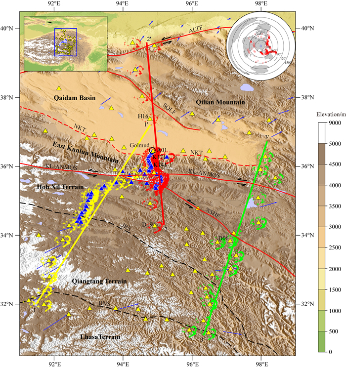
1 构造背景本次剖面南起拉萨地块北部,从南向北分别跨越了羌塘地块、可可西里地块和东昆仑—柴达木地块,向北延伸至祁连地块南部(图 1).班公—怒江缝合带是拉萨地块和羌塘地块的分界线,附近发育有侏罗系蛇绿岩及与其伴生的蛇绿混杂岩和构造混杂岩(肖序常和李廷栋, 2000).前人研究认为,班公—怒江缝合带南北两侧壳幔特征具有比较明显的差异(Tilmann et al., 2003;沈显杰等,1990).地球物理研究结果显示缝合带以南的地壳中存在局部熔融层(Nelson et al., 1996),最新研究认为,缝合带北部地壳可能同样存在地壳“通道流”或部分熔融层(Karplus et al., 2011; Li et al., 2014;魏文博等,2006).金沙江缝合带是羌塘地块和北部的可可西里地块间的分界线,天然地震研究推测金沙江缝合带可能是一条南倾的深达上地幔的断裂带(许志琴等,2001).
|
图 1 青藏高原中、北部及周边地质构造简图及地震台站分布 黄色三角形为Ascent地震台站,蓝色三角形为INDEPTH IV(I4)地震台站,蓝色箭头表示GPS观测得到的高原地表相对位移(形变)方向(Zhang et al., 2004),图中黄、红、绿十字分别代表剖面1-1′,2-2′,3-3′沿线台站接收函数在50 km深度的转换点位置.左上角插图为青藏高原简图,右上角插图为本文所用地震事件全球分布图. ALTF—阿尔金断裂,SQLF—南祁连断裂,KL-ANMQS—昆仑—阿尼玛卿缝合带,NKT—北昆仑逆冲断裂,XSHF—鲜水河断裂,JRS—金沙江缝合带,BNS—班公—怒江缝合带. Fig. 1 Simplified tectonic map of the Middle and Northern Tibetan plateau and its surrounding regions which shows the distribution of the seismic stations Yellow triangles are the Ascent seismic stations. Blue triangles are the INDEPTH IV (I4) stations. Blue arrows are the relative crustal movement in the northern Tibetan plateau observed by GPS(Zhang et al., 2004). Yellow, red, green crosses are transmission points of the receiving functions at 50 km depth along the profiles 1-1′, 2-2′, 3-3′, respectively. The inset in the top left shows the Tibetan Plateau in which blue rectangle delineates the study region, and the inset in the right top displays the distribution of the earthquakes used in this study. ALTF—Altyn-Tagh fault, SQLF—South Qilian fault, KL-ANMQS—Kunlun-Anyêmaqên suture, NKT—North Kunlun thrust, XSHF—Xianshuihe fault, JRS—Jinsha-River suture, BNS—Bangong-Nujiang suture. |
可可西里地块北侧以昆仑—阿尼玛卿缝合带为界,南侧以金沙江缝合带为界,西端被阿尔金断裂带截断(Burchfiel et al., 1989b; Molnar and Tapponnier, 1975; Yin and Harrison, 2000).可可西里地块四周是大地震活动带,先后发生过松潘6.7级地震(1976),玛尼7.9级地震(1997),昆仑山口西7.8级地震(2001),汶川8.0级地震(2008),玉树7.1级地震(2010)等,地壳运动十分活跃.
地质调查显示,东昆仑地区晚新生代广泛发育以北倾为主的大型逆冲推覆构造(Mcrivette et al., 2018; Wu et al., 2009;吴珍汉等,2007),地球物理结果显示昆仑—阿尼玛卿缝合带是一条北倾的逆冲活动断裂(Shi et al., 2009; Yin et al., 2007;刘志伟等,2016).GPS观测则表明,断裂现今以左旋走滑运动为主(Wang et al., 2001; Zhang et al., 2004). 2001年昆仑山口西MW7.8地震是该断裂走滑运动的结果,地震造成地表产生了一条长达约450 km的巨型破裂带(Lin et al., 2003; Lin et al., 2009;贺鹏超等, 2018).东昆仑山和柴达木盆地地表交界处普遍被第四系沉积物所覆盖,研究推测附近可能存在一条隐伏断层—北昆仑逆冲断裂(Burchfiel et al., 1989a).柴达木盆地是青藏高原内最大的沉积盆地,早期沉积主要形成于侏罗纪时期.盆地沉积中心经历了从西北向东南转移的过程,是一个大型的复向斜盆地(黄汉纯等,1989).在构造演化过程中,柴达木盆地基底经历了强烈的变形(Zhao et al., 2017),盆地东、西两侧的上地壳在新生代经历了不同的缩短变形,最东部缩短量不到1%,西部的缩短量则超过35%(Yin et al., 2008).
2 数据和方法INDEPTH IV项目于2007年在青藏高原中、北部布置了140个宽频地震台站(图 1),主要分布于羌塘地块、可可西里地块和东昆仑—柴达木地块,特别是在横跨东昆仑造山带中部地区布置了6~15 km间距的密集台站.这些台站记录了约2年的高质量地震数据,为我们进一步研究该区域的深部结构提供了很好的机会.本研究所使用的天然地震数据由两部分组成,其一为INDEPTH IV项目组于2007年在研究区布设的I4台网中的50个宽频地震台站(图 1蓝色三角),地震台站从拉萨地块北部开始,中间穿过金沙江缝合带和昆仑—阿尼玛卿缝合带,一直延伸到柴达木盆地北缘,台站间距最小约6 km.本文使用了这些台站在2007年6月到2008年8月间记录到的地震事件.其次是INDEPTH IV项目Ascent台网中的90个宽频地震台站于2007年4月到2009年2月间记录到的地震事件,这些台站相对稀疏,分散在东昆仑—柴达木地块、可可西里地块和羌塘地块,少量台站位于拉萨地块的北部.参考IRIS地震目录,本文选取震中距在30~90°之间,震级5.0级以上且P波初动震相较为清晰的地震,最终筛选出439个地震事件用于P波接收函数研究(图 1).
项目组对东昆仑山中部天然地震数据曾进行过处理,并发表了相关研究成果(Zhao et al., 2011;Karplus et al., 2019).但先前研究对数据的利用不够充分,获得的接收函数成像结果也不够清晰.为此,本文对INDEPTH-IV天然地震数据进行了重新处理,以便获得更为清晰的接收函数图像.此外,本次研究中我们不仅对东昆仑中部台站数据进行了重新处理,还利用东昆仑东部台站数据进行了接收函数研究,获得了造山带东部的壳幔结构图像.
接收函数(转换波)分离时,采用Reading等(2003)提出的坐标系旋转分离方法,通过地表响应改正获得P、SV和SH分量计算接收函数,该方法可以减少P波在径向分量对转换波的干扰.在计算P波接收函数(Langston, 1977)时,采用了时间域反褶积的方法(Ligoría and Ammon, 1999),成像时,时深转换应用了较为广泛的共转换点叠加成像方法(Kosarev et al., 1999).在计算及成像过程中,为保留足够多的高频地震信号,设置高斯滤波因子为2.Ps转换波延迟时间与转换界面的深度及其界面上部的平均速度有关,而转换波的振幅则与界面上下的波阻抗紧密相关.选择使用两层的层状速度模型,其中,地壳平均速度取VP=6.2 km·s-1,VS=3.54 km·s-1(Kind et al., 2002; Zhao et al., 2001),50 km以下的地幔速度取VP=8.1 km·s-1,VS=4.47 km·s-1,将所有接收函数按照层状速度模型计算射线路径,并偏移到三维空间中的转换点位置.最后,根据接收函数转换点分布选择3条剖面(图 1),将沿线台站的接收函数沿剖面的法线方向进行叠加,形成接收函数成像剖面.叠加过程中,叠加像元的水平宽度随深度变化,并且等于转换波震相的第一菲涅尔带的宽度.试验表明,这种选择可以最大程度地保留有用信息.对于地下倾斜或垂直错断结构,选择与该结构垂直的成像剖面来进行叠加,能够获得好的成像效果(Shi et al., 2004).东昆仑造山带中部断裂走向大致呈东西方向,剖面1-1′和2-2′的方向选为南北向,而造山带东部断裂为北西-南东向,故3-3′剖面方向选为NE20°.
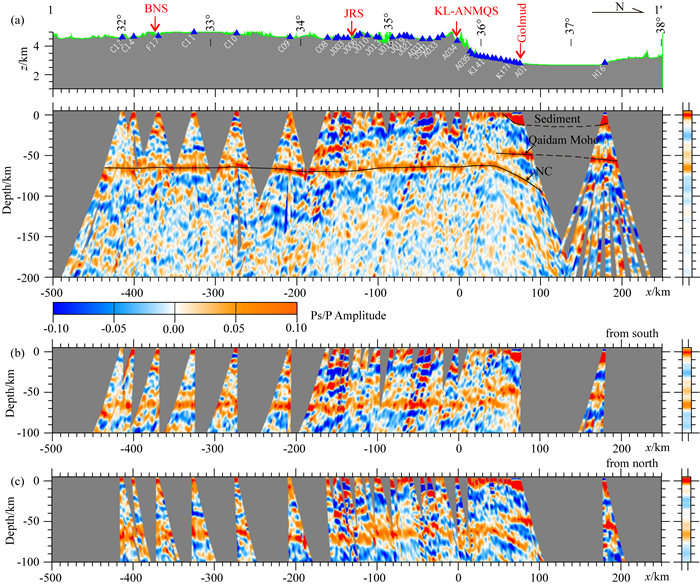
3 结果图 2a显示了沿1-1′剖面(图 1)获得的P波接收函数图像,比较清楚地显示了研究区下方的Moho面结构.从北拉萨地块到金沙江缝合带南侧,地震台站较为稀疏,莫霍面断续显示,深度约65 km,北羌塘地块莫霍面深度稍有增加.在班公—怒江缝合带下方莫霍面没有发现明显错断,在金沙江缝合带附近,莫霍面深度稍有加深.早期天然地震探测曾推测,昆仑—阿尼玛卿缝合带、金沙江缝合带是切穿地壳的岩石圈断裂(许志琴等,2001),但新的研究如P波接收函数(Kind et al., 2002; Shi et al., 2004)和S波接收函数(Kumar et al., 2006; Zhao et al., 2011)在两缝合带附近均得到了连续的莫霍图像.广角反射地震剖面得出羌塘地块南北两侧莫霍面深度为65~70 km,推测整个羌塘地块下莫霍面接近水平(李秋生等,2004b).李秋生等(2004a)认为在金沙江缝合带附近存在约5 km的莫霍面错断,本文接收函数结果图像未明显显示,只能看到缝合带附近莫霍面稍有起伏,接收函数分辨率不足可能是其主要原因.
|
图 2 剖面1-1′接收函数成像 (a)沿剖面所有方位接收函数叠加成像结果图;(b)、(c)为分别利用台站南、北侧接收函数叠加成像结果图. Fig. 2 Receiver function images along profile 1-1′ (a) Seismic image stacked with the receiver functions of all the back-azimuths; (b) Seismic image stacked with the data of the southern back-azimuths; (c) Same as (b) but with the data of the northern back-azimuths. |
从金沙江缝合带向北到东昆仑山下,莫霍面清晰、连续,深度约65 km.柴达木盆地南缘莫霍面深度约50 km,盆地北缘则约为55 km.在昆仑—阿尼玛卿缝合带以北约50 km处莫霍面存在约15 km的错断,前人的接收函数成像(Karplus et al., 2019; Zhao et al., 2011),广角反射地震(Karplus et al., 2011;李秋生等,2004b)及背景噪声成像(Li et al., 2014)等在东昆仑中部均发现这一现象.
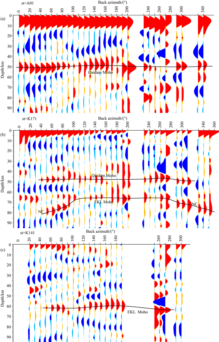
从北羌塘地块到昆仑—阿尼玛卿缝合带,地表以下15~30 km深度之间,以宽缓的负震相(蓝色)为主,向北延伸到东昆仑山下.在昆仑—阿尼玛卿缝合带以北约50 km、格尔木以南约30 km的位置,接收函数图像显示了一条清晰的转换震相带:在柴达木盆地约50 km深的莫霍面下方,北倾约35°,向下延伸到约100 km(图 2a中“NC”).分别利用来自台站南部和北部的接收函数进行成像,这一界面表现出不同的特征.台站南侧入射的P波接收函数图像上几乎观测不到该北倾界面(图 2b),而台站北侧入射的P波接收函数图像上则清楚显示了该界面(图 2c).这应该是由于来自台站南侧的P波入射到北倾界面时接近垂直,Ps转换震相不明显,而来自北侧的P波则是以一定角度(非垂直)入射,因此可以清晰地显示该界面(Nábělek et al., 2009).在莫霍面阶变附近台站以10°后方位角为间隔叠加的接收函数上,也可以看到东昆仑—柴达木交界处莫霍面的深部变化.深入柴达木盆地内的台站A01的接收函数(图 3a)显示了单一的约50 km的盆地莫霍面;台站K171的接收函数(图 3b)不仅存在50 km的盆地莫霍面,而且显示了北倾界面(图 3b中“NC”);更南部台站K141的接收函数(图 3c)显示东昆仑山下单一的莫霍面,这与接收函数成像图所反映的莫霍面的变化是一致的.
|
图 3 台站A01、K171、K141以10°后方位角间隔叠加的接收函数 NC为台站K171观测到的北倾界面,延迟时间已利用CCP偏移方法转化为深度. Fig. 3 Receiver functions stacked at 10°back-azimuth interval for station A01(a), K171(b) and K141(c), respectively The north-dipping interface NC is observed at station K171. Delay time has been converted into depth with the CCP migration method. |
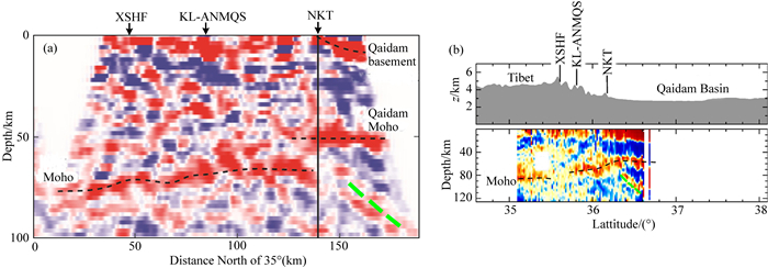
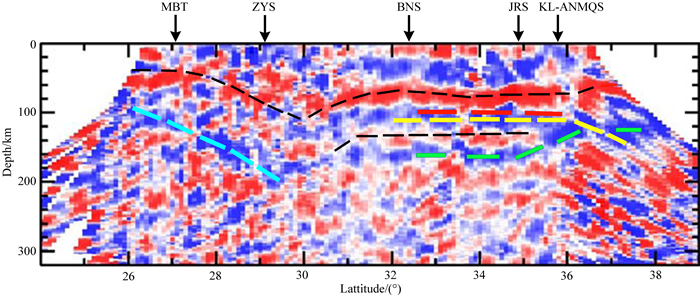
Karplus等(2019)利用与本研究部分相同的地震数据获得的接收函数图像,显示了类似的北倾界面(图 4),但本文结果(图 2)更加清晰.由于北倾界面比较模糊,Karplus等(2019)没有注意到这一界面(图 4a).Zhao等(2011)P波接收函数成像获得了相对清晰的北倾界面(图 4b),但没有给出解释.根据S波接收函数图像(图 5),Zhao等(2011)认为柴达木莫霍面下部可能存在亚洲大陆岩石圈向南俯冲,Lei等(2014)也提出了类似的观点.但深入分析Zhao等(2011)给出的S波接收函数图像(图 5),可以看出青藏高原下部的负转换界面(原文红色虚线表示,本文表示为黄色虚线)一直向北延伸到了柴达木盆地地幔深部,这与P波接收函数反映的北倾界面是一致的.
|
图 4 前人给出的P波接收函数成像剖面 (a), (b)分别为Karplus等(2019)和Zhao等(2011)给出的接收函数成像剖面,其剖面位置与本文2-2′剖面基本相同,绿色虚线—对应于本次研究确定的北倾界面.其他断裂名称见图 1. Fig. 4 P-wave receiver function images obtained by Karplus et al. (2019) and Zhao et al.(2011), respectively The location of the profiles are similar to the 2-2′ in this paper. The green dashed line—the North dipping converter (NC) identified in this study. Other faults are the same as in Fig. 1. |
|
图 5 前人给出的S波接收函数成像(Zhao et al., 2011) 图中的蓝色、红色、绿色虚线取自原文,分别表示印度、西藏和亚洲板块的岩石圈地幔与软流圈的界线,上部黑色虚线表示莫霍面,下部黑色虚线表示亚洲岩石圈顶界面(莫霍面)的弱显示.黄色虚线为本文加入,表示青藏高原岩石圈地幔.MBT-喜马拉雅主边界断裂,ZYS-雅鲁藏布江缝合带,其它断裂同图 1. Fig. 5 S-wave receiver function image obtained by Zhao et al. (2011) Blue, red, and green dashed lines are LAB of Indian, Tibetan and Asian plates, respectively. The upper black dashed line is the Moho, and the lower is the weak indication of the top (Moho) of Asian lithosphere. The yellow dashed line added by this paper denotes the Tibetan lithosphere mantle. MBT-the Himalaya Main Boundary Thrust, ZYS-Zangbo-Yarlung Suture, other faults are the same as in Fig. 1. |
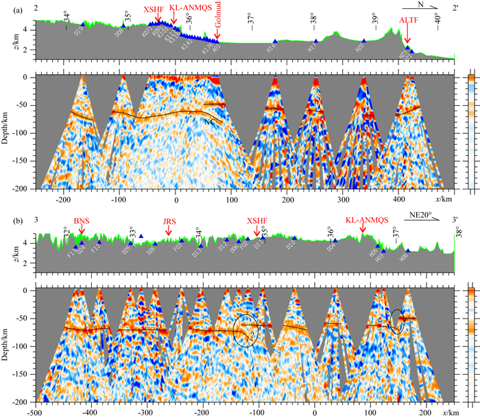
沿剖面2-2′(图 6a),昆仑—阿尼玛卿缝合带以北莫霍面深度约60 km,向南莫霍面深度逐渐增大,在鲜水河断裂南部达到最深70 km.这与李秋生等(2004a)利用广角反射地震得出东昆仑山向南莫霍面逐渐加深是一致的.在该剖面图上也可以清楚地看到北倾界面,与剖面1-1′显示的结果相同.
|
图 6 剖面2-2′和3-3′的P波接收函数成像剖面 Fig. 6 P-wave receiver function imaging results along profiles 2-2′ and 3-3′, respectively |
沿剖面3-3(图 6b),台站相对稀疏,但也可以发现断裂带附近莫霍面的一些特征.在鲜水河断裂南侧附近,莫霍面深度从南向北减小了约10 km(图 6b).同时在莫霍面突变位置,可以看到北倾界面.Vergne等(2002)沿玉树—共和一线的接收函数剖面也发现金沙江缝合带与鲜水河断裂附近可能存在莫霍面错断.虽然不如图 1-1′所示的那么清晰,从图 6b也可以看到,在昆仑—阿尼玛卿缝合带以北约50 km处莫霍面深度从约70 km减小到约50 km(图 4b),与天然地震波形模拟(Zhu and Helmberger, 1998)和接收函数成像(Shi et al., 2009; Vergne et al., 2002)在东昆仑山东部观测到的莫霍面突变现象具有一致性.
4 讨论 4.1 可可西里岩石圈地幔北向俯冲沿东昆仑山中部一线(图 2a, b),昆仑—阿尼玛卿缝合带北部的北倾界面,表明可可西里地块岩石圈地幔可能俯冲到了柴达木地幔深处.在可可西里地块和羌塘地块,Pn波沿莫霍面传播速度较低(McNamara et al., 1997; Ni and Barazangi, 1983; Zhou and Lei, 2016),面波层析成像(Li et al., 2013; Zhang et al., 2011;郭飚等,2004)发现藏北地区岩石圈地幔具有低速特征,柴达木地幔则为高速(Zhou and Lei, 2016).层析成像结果还显示东昆仑山低速的岩石圈地幔在柴达木南缘附近斜向下延伸到柴达木地幔深处(Ceylan et al., 2012;李贞等,2019).前人研究认为,可可西里大洋从二叠纪末期开始向东昆仑—柴达木地块下俯冲,东昆仑山作为陆缘弧地带,发生火山喷发和深成岩浆上侵,从而抬升成山,柴达木盆地作为弧后盆地发生伸展和下沉(Yin and Harrison, 2000;刘志伟等,2016;赵文津等,2014).在东昆仑山南部地质调查发现三叠系超深俯冲蛇绿岩(Dong et al., 2018),可能是可可西里大洋向北俯冲到东昆仑山下的证据.在持续俯冲碰撞下,东昆仑山继续抬升,海拔不断升高,可可西里岩石圈地幔则像印度岩石圈的持续俯冲一样,一直向北俯冲.
青藏高原东北缘SKS波分裂和Ps震相分析表明,东昆仑地壳和上地幔快波方向大致平行,二者可能发生耦合变形(郭桂红等,2019).因此,在下地壳和上地幔深度范围内,较软的可可西里地块物质向北侵入到柴达木地幔,使柴达木莫霍面与北倾界面之间充填壳幔混合物质,它们与界面下部物质之间波阻抗差相对较小,这可能是研究区内北倾界面比较模糊的原因.在可可西里岩石圈地幔向北俯冲的背景下,东昆仑造山带处于俯冲造山的环境中,南部广泛发育新生代以北倾为主的大型逆冲推覆构造(Wu et al., 2009;吴珍汉等,2007).Mcrivette等(2018)在东昆仑北部也发现了逆冲推覆断裂的证据.
北羌塘地块以及可可西里地块中地壳(约15~30 km)深度存在宽缓的蓝色转换震相带(波速随深度减小),向北在昆仑—阿尼玛卿缝合带南侧开始变得复杂.可可西里地块地表广泛分布最厚可达16 km的晚三叠系复理石沉积(Gu, 1994; Nie et al., 1994; Yin and Harrison, 2000),且三叠系复理石不仅分布在可可西里地块,在金沙江缝合带南部也有分布(Yin and Harrison, 2000).广角反射地震(Karplus et al., 2011)获得的P波速度结构显示复理石底界面在昆仑—阿尼玛卿缝合带南侧变浅.因此,蓝色转换震相带顶部可能是地表复理石的底界面,而复理石下部宽缓的蓝色转换震相带,可能是中地壳广泛存在的低速层.背景噪声成像(Li et al., 2014)、广角反射地震(Karplus et al., 2011)、地震层析成像(赵文津等, 2004)揭示可可西里地块中地壳存在低速特征.大地电磁(Wei et al., 2001;魏文博等,2006)则显示中下地壳是高导异常区.因此,可可西里中地壳可能存在地壳流或部分熔融物质,从而使这一深度表现出高电导率、低地震波速异常等特征.大地电磁模拟结果(Le Pape et al., 2012)证明可可西里地块的地壳熔融体可以向北侵入到东昆仑山下甚至更远的距离.东昆仑山隆升可能是可可西里地块中地壳物质挤入东昆仑山下,受到柴达木盆地刚性地块的阻挡增厚造成的(Li et al., 2014).
柴达木刚性地块的阻挡还会造成该区域应力积累,地壳流改向东运动,区域构造应力场发生转变,造成东西方向应力增加.许志琴等(2001)根据藏北地区天然地震探测剖面结果推测高原北部存在岩石圈规模的向东挤出作用.现今GPS观测结果显示东昆仑造山带是一个比其他邻近区域剪切应力更加集中的地区(Zhang et al., 2004).东西方向应力增加也造成昆仑—阿尼玛卿缝合带以走滑断裂为主的运动.2001年昆仑山口西MW7.8地震震源机制解结果表明昆仑—阿尼玛卿缝合带主要以走滑运动为主(Lin et al., 2009;贺鹏超等,2018).藏北地区剪切波分裂研究表明,快波方向与金沙江缝合带、班公—怒江缝合带走向存在较大的夹角,在昆仑—阿尼玛卿缝合带附近则具有一致性(Eken et al., 2013;史大年等,1996),古地磁研究(李朋武等,2001)和GPS观测结果(Wang et al., 2001)显示现今藏北地区整体处于顺时针旋转的构造背景.Zhang等(2009, 2010),Wang等(2018)在青藏高原东北部的接收函数发现龙门山下的莫霍面斜向下延伸到四川盆地下部,Liu等(2014)根据该区域的层析成像结果认为松潘—甘孜地块中地壳流在龙门山与四川盆地交界附近由向东改向东南流动,造成该区域顺时针为主的应力场.这与本文在东昆仑山地区观测到的现象具有相似的特征.
大地电磁研究发现,在柴达木盆地结晶基底存在一条下陷约4 km,宽约12 km的大裂谷——昆北裂谷(赵文津和宋洋,2017;赵文津等,2014).大地电磁成像上(魏文博等,2006),裂谷附近,一条高导层带从地表一直延伸到达软流圈.裂谷一般代表了地表与深部热液流体联系的通道,而该处裂谷的位置与莫霍面阶变对应的地表位置接近,推测裂谷也可能与深部的岩石圈地幔向北俯冲存在一定的联系.
沿东昆仑山东部一线(图 6b),我们发现鲜水河断裂南侧附近,从南向北莫霍面深度变浅了约10 km,可能表明莫霍面在鲜水河断裂位置也存在阶变的特征.鲜水河断裂两侧均为三叠系复理石,崔军文等(1992)曾提出它具有缝合带性质,可能是晚二叠世-中三叠世时期大洋洋壳向北俯冲消减闭合形成的.下部的北倾界面可能是南部岩石圈在鲜水河断裂南侧向北俯冲的表现.由于我们研究数据有限,这一结果有待将来更深入研究的证实.在昆仑—阿尼玛卿缝合带北侧,莫霍面深度从约70 km减小到约50 km,这与Shi等(2009),Zhu和Helmberger(1998)在柴达木盆地东缘发现莫霍面存在明显的阶变特征是一致的.鉴于东昆仑—柴达木交界附近东部和中部均存在莫霍面阶变,我们认为可可西里岩石圈地幔可能在东昆仑山东部和中部均俯冲到了柴达木地幔深处.
Kind等(2002)、Kosarev等(1999)P波接收函数成像结果得出昆仑—阿尼玛卿缝合带约100 km深度存在南倾界面,认为是亚洲岩石圈在东昆仑—柴达木交界处向南俯冲的证据.我们分析发现,其接收函数成像利用了东昆仑—柴达木地块内很少的地震台站数据,台站间较大的距离可能对接收函数成像造成了较大影响.Rayleigh波层析成像在东昆仑山下发现深达200 km的低速体也不支持亚洲大陆岩石圈在柴达木盆地南缘向南俯冲(Ceylan et al., 2012),前人接收函数研究(Shi et al., 2009; Karplus et al., 2011)及本文的研究结果也不支持这一结论.
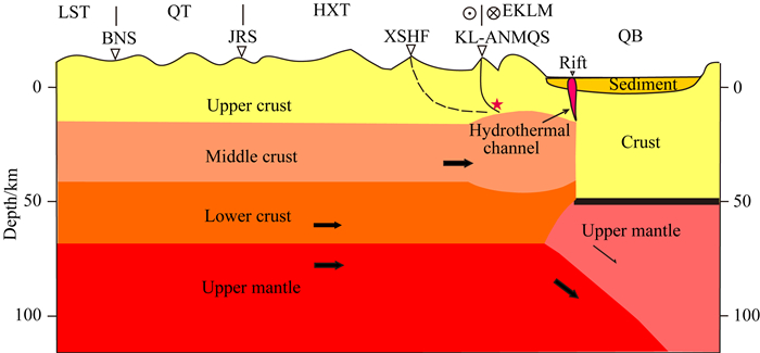
4.2 东昆仑山造山模式根据本文接收函数成像结果,亚洲岩石圈在柴达木南缘向南俯冲可能并不存在,可可西里地块的岩石圈地幔在东昆仑—柴达木交界附近向北俯冲到盆地的地幔深处,同时下地壳物质也随上地幔向柴达木地幔深部俯冲.中地壳物质向北运动,遇到刚性柴达木地壳的阻挡在东昆仑造山带下发生挤压增厚,使东昆仑山海拔不断抬升,格尔木附近的裂谷可能是与深部热液联系的通道.由于中地壳在东昆仑山下聚集增厚并向东改向,使得造山带内应力变为以近东西方向剪切为主,造成昆仑缝合带现今以走滑为主的运动.据此,我们提出了图 7的东昆仑山造山新模式.
|
图 7 东昆仑造山新模式 LST—拉萨地块,QT—羌塘地块,HXT—可可西里地块,EKLM—东昆仑山,QB—柴达木盆地,断层名称见图 1. Fig. 7 New orogenic model for the uplift of the eastern Kunlun mountains LST—Lhasa Terrain, QT—Qiangtang Terrain, HXT—Hoh Xil Terrain, EKLM—East Kunlun Mountains, QB—Qaidam Basin, the faults are the same as in Fig. 1 |
利用分布于青藏高原中、北部的140个地震台站记录到的约2年的地震数据,通过接收函数成像方法获得了高原中、北部的壳幔结构,结果显示:
在昆仑—阿尼玛卿缝合带以北约50 km位置,莫霍面深度由东昆仑山下的约65 km阶变为柴达木盆地南缘的约50 km.可可西里地块中地壳存在宽缓的负转换震相带,可能是中地壳低速层的反映.在可可西里岩石圈地幔和柴达木岩石圈地幔之间存在北倾界面,我们认为是可可西里岩石圈地幔向北俯冲到柴达木地幔深部的证据.两岩石圈地幔的相互作用造成东昆仑造山带处于俯冲构造背景下,是东昆仑南部逆冲推覆构造产生的主要原因.中地壳物质向北运动遇到柴达木盆地阻挡可能发生挤压增厚并向东改向,是东昆仑山隆升的主要原因,也是现今东昆仑地区整体向东旋转的构造应力场的重要原因.本文结果不支持亚洲岩石圈地幔在柴达木南缘向南俯冲的观点,综合前人研究成果,本文提出了东昆仑山的造山新模式.
致谢 感谢审稿专家提出的宝贵意见.
Bao X W, Song X D, Xu M J, et al. 2013. Crust and upper mantle structure of the North China Craton and the NE Tibetan Plateau and its tectonic implications. Earth and Planetary Science Letters, 369-370: 129-137. DOI:10.1016/j.epsl.2013.03.015 |
Beaumont C, Jamieson R A, Nguyen M H, et al. 2004. Crustal channel flows:1. Numerical models with applications to the tectonics of the Himalayan-Tibetan orogen. Journal of Geophysical Research:Solid Earth, 109(B6): B06406. DOI:10.1029/2003jb002809 |
Burchfiel B C, Deng Q D, Molnar P, et al. 1989a. Intracrustal detachment within zones of continental deformation. Geology, 17(8): 748-752. DOI:10.1130/0091-7613(1989)017〈0448:IDWZOC〉2.3.CO;2 |
Burchfiel B C, Molnar P, Zhao Z Y, et al. 1989b. Geology of the Ulugh Muztagh area, northern Tibet. Earth and Planetary Science Letters, 94(1-2): 57-70. DOI:10.1016/0012-821x(89)90083-6 |
Ceylan S, Ni J, Chen J Y, et al. 2012. Fragmented Indian plate and vertically coherent deformation beneath eastern Tibet. Journal of Geophysical Research:Solid Earth, 117(B11): B11303. DOI:10.1029/2012JB009210 |
Clark M K, Royden L H. 2000. Topographic ooze:Building the eastern margin of Tibet by lower crustal flow. Geology, 28(8): 703-706. DOI:10.1130/0091-7613(2000)28〈703:TOBTEM〉2.0.CO;2 |
Cui J W, Zhu H, Wu C D. 1992. A comprehensive study on the lithospheric cross section of Yadong-Gulmod-Lithospheric deformation and its dynamics in Qinghai-Tibet Plateau (in Chinese). Beijing: Geological Publishing House.
|
Dong Y P, He D F, Sun S S, et al. 2018. Subduction and accretionary tectonics of the East Kunlun orogen, western segment of the Central China Orogenic System. Earth-Science Reviews, 186: 231-261. DOI:10.1016/j.earscirev.2017.12.006 |
Eken T, Timann F, Machie J, et al. 2013. Seismic Anisotropy from SKS Splitting beneath Northeastern Tibet. Bulletin of the Seismological Society of America, 103(6): 3362-3371. DOI:10.1785/0120130054 |
Gao R. 1995. A review for the geophysical investigation of the crust and upper mantle of Qinghai-Tibet Plateau (upper). Geology in China (in Chinese), (4): 26-28. |
Gu X X. 1994. Geochemical characteristics of the Triassic Tethys-turbidites in northwestern Sichuan, China:Implications for provenance and interpretation of the tectonic setting. Geochimica et Cosmochimica Acta, 58(21): 4615-4631. DOI:10.1016/0016-7037(94)90195-3 |
Guo B, Liu Q Y, Chen J H, et al. 2004. Seismic tomographic imaging of the crust and upper mantle beneath the Northeastern edge of the Qinghai-Xizang plateau and the Ordos area. Chinese Journal of Geophysics (in Chinese), 47(5): 790-797. |
Guo G H, Wu C L, Tang G B, et al. 2019. Seismic anisotropy of the northeastern margin of the Tibetan Plateau derived from analysis of SKS and Pms seismic phases. Chinese Journal of Geophysics (in Chinese), 62(5): 1650-1662. DOI:10.6038/cjg2019N0093 |
He P C, Wang M, Wang Q, et al. 2018. Rheological structure of lithosphere in northern Tibet inferred from postseismic deformation modeling of the 2001 MW7.8 Kokoxili earthquake. Chinese Journal of Geophysics (in Chinese), 61(2): 531-544. DOI:10.6038/cjg2018L0189 |
Huang H C, Zhou X Q, Wang C L. 1989. Tectonic evolution of the Qaidam basin and the regularity of oil accumulation. Geological Review (in Chinese), 35(4): 314-323. |
Karplus M S, Zhao W J, Klemperer S L, et al. 2011. Injection of Tibetan crust beneath the south Qaidam Basin:Evidence from INDEPTH IV wide-angle seismic data. Journal of Geophysical Research:Solid Earth, 116(B7): B07301. DOI:10.1029/2010JB007911 |
Karplus M S, Klemperer S L, Zhao W J, et al. 2019. Receiver-function imaging of the lithosphere at the Kunlun-Qaidam boundary, Northeast Tibet. Tectonophysics, 759: 30-43. DOI:10.1016/j.tecto.2019.03.015 |
Kind R, Yuan X H, Saul J, et al. 2002. Seismic images of crust and upper mantle beneath Tibet:Evidence for Eurasian plate subduction. Science, 298(5596): 1219-1221. DOI:10.1126/science.1078115 |
Kosarev G, Kind R, Sobolev S V, et al. 1999. Seismic evidence for a detached indian lithospheric mantle beneath Tibet. Science, 283(5406): 1306-1309. DOI:10.1126/science.283.5406.1306 |
Kumar P, Yuan X H, Kind R, et al. 2006. Imaging the colliding Indian and Asian lithospheric plates beneath Tibet. Journal of Geophysical Research:Atmospheres, 111(B6): B06308. DOI:10.1029/2005JB003930 |
Langston C. 1977. The effect of planar dipping structures on the source and receiver for constant ray parameter. Bulletin of the Seismological Society of America, 67(4): 1029-1050. |
Le Pape F, Jones A G, Vozar J, et al. 2012. Penetration of crustal melt beyond the Kunlun Fault into northern Tibet. Nature Geoscience, 5(5): 330-335. DOI:10.1038/ngeo1449 |
Lei J S, Li Y, Xie F R, et al. 2014. Pn anisotropic tomography and dynamics under eastern Tibetan plateau. Journal of Geophysical Research:Solid Earth, 119(3): 2174-2198. DOI:10.1002/2013JB010847 |
Li H Y, Shen Y, Huang Z X, et al. 2014. The distribution of the mid-to-lower crustal low-velocity zone beneath the northeastern Tibetan Plateau revealed from ambient noise tomography. Journal of Geophysical Research:Solid Earth, 119(3): 1954-1970. DOI:10.1002/2013JB010374 |
Li L, Li A B, Shen Y, et al. 2013. Shear wave structure in the northeastern Tibetan Plateau from Rayleigh wave tomography. Journal of Geophysical Research:Solid Earth, 118(8): 4170-4183. DOI:10.1002/jgrb.50292 |
Li P W, Cui J W, Gao R, et al. 2001. New cenozoic paleomagnetic data from Qaidam massif and their tectonic implications. Acta Geoscientica Sinica (in Chinese), 22(6): 563-568. DOI:10.3321/j.issn:1006-3021.2001.06.016 |
Li Q S, Peng S P, Gao R. 2004a. A review on the Moho discontinuity beneath the Tibetan Plateau. Geological Review (in Chinese), 50(6): 598-612. DOI:10.3321/j.issn:0371-5736.2004.06.011 |
Li Q S, Peng S P, Gao R, et al. 2004b. Deep tectonic background of the 8.1 Ms earthquake in the East Kunlun. Acta Geoscientica Sinica (in Chinese), 25(1): 11-16. DOI:10.3321/j.issn:1006-3021.2004.01.002 |
Li Z, Guo B, Liu Q Y, et al. 2019. P-wave structure of upper mantle beneath the Northeastern Tibetan Plateau from multi-scale seismic tomography. Chinese Journal of Geophysics (in Chinese), 62(4): 1244-1255. DOI:10.6038/cjg2019J0392 |
Ligoría J P, Ammon C J. 1999. Iterative deconvolution and receiver-function estimation. Bulletin of the Seismological Society of America, 89(5): 1395-1400. DOI:10.1029/1999JB900220 |
Lin A, Kikuchi M, Fu B. 2003. Rupture segmentation and process of the 2001 MW 7.8 central Kunlun, China, earthquake. Bulletin of the Seismological Society of America, 93(6): 2477-2492. DOI:10.1785/0120020179 |
Lin A M, Ren Z K, Jia D, et al. 2009. Co-seismic thrusting rupture and slip distribution produced by the 2008 MW7.9 Wenchuan earthquake, China. Tectonophysics, 471(3-4): 203-215. DOI:10.1016/j.tecto.2009.02.014 |
Liu Q Y, Van Der Hilst R D, Li Y, et al. 2014. Eastward expansion of the Tibetan Plateau by crustal flow and strain partitioning across faults. Nature Geoscience, 7(5): 361-365. DOI:10.1038/ngeo2130 |
Liu Z W, Zhao W J, Wu Z H, et al. 2016. East Kunlun Orogeny's uplift uncovered by deep reflection seismic data in INDEPTH IV. Chinese Journal of Geophysics (in Chinese), 59(9): 3211-3222. DOI:10.6038/cjg20160907 |
McNamara D E, Walter W R, Owens T J, et al. 1997. Upper mantle velocity structure beneath the Tibetan Plateau from Pn travel time tomography. Journal of Geophysical Research:Solid Earth, 102(B1): 493-505. DOI:10.1029/96JB02112 |
McRivette M W, Yin A, Chen X H, et al. 2018. Cenozoic basin evolution of the central Tibetan plateau as constrained by U-Pb detrital zircon geochronology, sandstone petrology, and fission-track thermochronology. Tectonophysics, 751: 150-179. DOI:10.1016/j.tecto.2018.12.015 |
Meyer B, Tapponnier P, Bourjot L, et al. 1998. Crustal thickening in Gansu-Qinghai, lithospheric mantle subduction, and oblique, strike-slip controlled growth of the Tibet plateau. Geophysical Journal International, 135(1): 1-47. DOI:10.1046/j.1365-246X.1998.00567.x |
Mock C, Arnaud N O, Cantagrel J M. 1999. An early unroofing in northeastern Tibet? Constraints from 40Ar/39Ar thermochronology on granitoids from the eastern Kunlun range (Qianghai, NW China). Earth and Planetary Science Letters, 171(1): 107-122. DOI:10.1016/S0012-821X(99)00133-8 |
Molnar P, Tapponnier P. 1975. Cenozoic tectonics of Asia:effects of a continental collision. Science, 189(4201): 419-426. DOI:10.1126/science.189.4201.419 |
Nábělek J, Hetényi G, Vergne J, et al. 2009. Underplating in the Himalaya-Tibet collision zone revealed by the Hi-CLIMB experiment. Science, 325(5946): 1371-1374. DOI:10.1126/science.1167719 |
Nelson K D, Zhao W J, Brown L D, et al. 1996. Partially molten middle crust beneath southern Tibet:Synthesis of Project INDEPTH results. Science, 274(5293): 1684-1688. DOI:10.1126/science.274.5293.1684 |
Ni J, Barazangi M. 1983. High-frequency seismic wave propagation beneath the Indian Shield, Himalayan Arc, Tibetan Plateau and surrounding regions:high uppermost mantle velocities and efficient Sn propagation beneath Tibet. Geophysical Journal of the Royal Astronomical, 72(3): 665-689. DOI:10.1111/j.1365-246x.1983.tb02826.x |
Nie S Y, Yin A, David B R, et al. 1994. Exhumation of the Dabie Shan ultra-high-pressure rocks and accumulation of the Songpan-Ganzi flysch sequence, central China. Geology, 22(11): 999-1002. DOI:10.1130/0091-7613(1994)022<0999:EOTDSU>2.3.CO;2 |
Reading A, Kennett B, Sambridge M. 2003. Improved inversion for seismic structure using transformed, S-wavevector receiver functions:Removing the effect of the free surface. Geophysical Research Letters, 30(19): 1981. DOI:10.1029/2003GL018090 |
Shen X J, Zhang W R, Yang S Z, et al. 1990. Heat flow evidence for the differentiated crust-mantle thermal structures of the northern and southern terranes of the Qinghai-Xizang plateau. Acta Geoscientica Sinica (in Chinese), (2): 203-214. |
Shi D N, Dong Y J, Jiang M, et al. 1996. Shear wave anisotropy of the upper mantle beneath the Tingri of Tibet to Golmud of Qinghai. Acta Geoscientica Sinica (in Chinese), 70(4): 291-297. |
Shi D N, Zhao W J, Brown L, et al. 2004. Detection of southward intracontinental subduction of Tibetan lithosphere along the Bangon-Nujiang suture by P-to-S converted waves. Geology, 32(3): 209-212. DOI:10.1130/G19814.1 |
Shi D N, Yang S, Zhao W J, et al. 2009. Seismic evidence for a Moho offset and south-directed thrust at the easternmost Qaidam-Kunlun boundary in the Northeast Tibetan plateau. Earth and Planetary Science Letters, 288(1-2): 329-334. DOI:10.1016/j.epsl.2009.09.036 |
Tapponnier P, Mercier J L, Qiu H R. 1981. The Tibetan side of the India-Eurasia collision. Nature, 294: 405-410. DOI:10.1038/294405a0 |
Tapponnier P, Xu Z Q, Roger F, et al. 2001. Oblique stepwise rise and growth of the Tibet Plateau. Science, 294(5547): 1671-1677. DOI:10.1126/science.105978 |
Tilmann F, Ni J, INDEPTH Ⅲ Seismic Team. 2003. Seismic imaging of the downwelling Indian lithosphere beneath cental Tibet. Science, 300(5624): 1424-1427. DOI:10.1126/science.1082777 |
Vergne J, Wittlinger G, Hui Q, et al. 2002. Seismic evidence for stepwise thickening of the crust across the NE Tibetan plateau. Earth and Planetary Science Letters, 203(1): 25-33. DOI:10.1016/s0012-821x(02)00853-1 |
Xiao X C, Li T D. 2000. Tectonic Evolution and Uplift Mechanism of Qinghai-Tibet Plateau (in Chinese). Guangzhou: Guangdong Science and Technology Press.
|
Xu Z Q, Yang J S, Li H B, et al. 2006. The Qinghai-Tibet plateau and continental dynamics:A review on terrain tectonics, collisional orogenesis, and processes and mechanisms for the rise of the plateau. Geology in China, 33(2): 221-238. DOI:10.3969/j.issn.1000-3657.2006.02.001 |
Xu Z Q, Yang J S, Jiang M, et al. 2001. Lithospheric structures and shear faults in eastern Kunlun-Qiangtang region of the northern Qinghai-Tibet Plateau. Sci China Ser D-Earth Sci (in Chinese), 31(S1): 1-7. DOI:10.1360/zd2001-31-S1-1 |
Wei W B, Unsworth M, Jones A, et al. 2001. Detection of Widespread Fluids in the Tibetan Crust by Magnetotelluric Studies. Science, 292(5517): 716-718. DOI:10.1126/science.1010580 |
Wang Q, Zhang P Z, Freymueller J T, et al. 2001. Present-day crustal deformation in China constrained by global positioning system measurements. Science, 294(5542): 574-577. DOI:10.1126/science.1063647 |
Wang X, Chen L, Ai Y S, et al. 2018. Crustal structure and deformation beneath eastern and northeastern Tibet revealed by P-wave receiver functions. Earth and Planetary Science Letters, 497: 69-79. DOI:10.1016/j.epsl.2018.06.007 |
Wang Y, Zhang W M, Zhan J G, et al. 2004. Gravity change detected by repeated absolute gravity measurements in the western Yunnan and Lhasa, China and its implication. Chinese Journal of Geophysics (in Chinese), 47(1): 95-100. |
Wei W B, Jin S, Ye G F, et al. 2006. Conductivity structure of crust and upper mantle beneath the northern Tibetan Plateau:Results of super-wide band magnetotelluric sounding. Chinese Journal of Geophysics (in Chinese), 49(4): 1215-1225. |
Wu Z H, Ye P S, Zhao W J, et al. 2007. Late Cenozoic overthrust system in the southern East Kunlun Mountains, China. Geological Bulletin of China (in Chinese), 26(4): 448-456. DOI:10.3969/j.issn.1671-2552.2007.04.011 |
Wu Z H, Ye P S, Patrick B J, et al. 2009. Late oligocene-early miocene thrusting in southern east Kunlun mountains, Northern Tibetan plateau. Journal of Earth Science, 20(2): 381-390. DOI:10.1007/s12583-009-0031-2 |
Yin A, Harrison T M. 2000. Geologic evolution of the Himalayan-Tibetan orogen. Annual Review of Earth and Planetary Sciences, 28(2000): 211-280. DOI:10.1146/annurev.earth.28.1.211 |
Yin A, Dang Y Q, Zhang M, et al. 2007. Cenozoic tectonic evolution of Qaidam basin and its surrounding regions (part 2): Wedge tectonics in southern Qaidam basin and the Eastern Kunlun Range.//Sears J W, Harms T A, Evenchick C A, eds. Whence the Mountains? Inquiries into the Evolution of Orogenic Systems: A Volume in Honor of Raymond A. Price. Geological Society of America Special Paper, 433: 369-390, doi: 10.1130/2007.2433(18).
|
Yin A, Dang Y Q, Wang L C, et al. 2008. Cenozoic tectonic evolution of Qaidam basin and its surrounding regions (Part 1):The southern Qilian Shan-Nan Shan thrust belt and northern Qaidam basin. GSA Bulletin, 120(7-8): 813-846. DOI:10.1130/b26180.1 |
Zhang J Z, Wang Y H, Chen Y, et al. 2009. Crustal structure across Longmenshan fault belt from passive source seismic profiling. Geophysical Research Letters, 36(17): L17310. DOI:10.1029/2009GL039580 |
Zhang P Z, Shen Z K, Wang M, et al. 2004. Continuous deformation of the Tibetan Plateau from global positioning system data. Geology, 32(9): 809-812. DOI:10.1130/g20554.1 |
Zhang Q, Sandvol E, Ni J, et al. 2011. Rayleigh wave tomography of the northeastern margin of the Tibetan Plateau. Earth and Planetary Science Letters, 304(1-2): 103-112. DOI:10.1016/j.epsl.2011.01.021 |
Zhang Z J, Yuan X H, Chen Y, et al. 2010. Seismic signature of the collision between the east Tibetan escape flow and the Sichuan Basin. Earth and Planetary Science Letters, 292(3-4): 254-264. DOI:10.1016/j.epsl.2010.01.046 |
Zhao J M, Shah S T H, Zhang H, et al. 2017. Density and magnetic intensity of the crust and uppermost mantle across the northern margin of the Tibetan Plateau. Physics of the Earth and Planetary Interiors, 265: 15-22. DOI:10.1016/j.pepi.2017.02.003 |
Zhao W J, Mechie J, Brown L D, et al. 2001. Crustal structure of central Tibet as derived from Project INDEPTH wide-angle seismic data. Geophysical Journal International, 145(2): 486-498. DOI:10.1046/j.0956-540x.2001.01402.x |
Zhao W J, Kumar P, Mechie J, et al. 2011. Tibetan plate overriding the Asian plate in central and northern Tibet. Nature Geoscience, 4(12): 870-873. DOI:10.1038/ngeo1309 |
Zhao W J, Wu Z H, Shi D N, et al. 2014. Deep structure and orogenic mechanism of the Kunlun Mountains. Geology in China (in Chinese), 41(1): 1-18. DOI:10.3969/j.issn.1000-3657.2014.01.001 |
Zhao W J, Xue G Q, Wu Z H, et al. 2004. Fine velocity structure of the upper mantle beneath the Xizang plateau from tomography and its geological interpretations. Chinese Journal of Geophysics (in Chinese), 47(3): 449-455. |
Zhao W J, Song Y. 2017. Some scientific problems in the study of the formation and the evolution of the Tibet Plateau. Science & Technology Review (in Chinese), 35(6): 23-35. DOI:10.3981/j.issn.1000-7857.2017.06.002 |
Zhou Z G, Lei J S. 2016. Pn anisotropic tomography and mantle dynamics beneath China. Physics of the Earth and Planetary Interiors, 257: 193-204. DOI:10.1016/j.pepi.2016.06.005 |
Zhu L P, Helmberger D V. 1998. Moho offset across the northern margin of the Tibetan Plateau. Science, 281(5380): 1170-1172. DOI:10.1126/science.281.5380.1170 |
崔军文, 朱红, 武长得. 1992. 亚东-格尔木岩石圈地学断面综合研究-青藏高原岩石圈变形及其动力学. 北京: 地质出版社.
|
高锐. 1995. 青藏高原地壳上地幔地球物理调查研究成果综述(上). 中国地质, (4): 26-28. |
郭飚, 刘启元, 陈九辉, 等. 2004. 青藏高原东北缘-鄂尔多斯地壳上地幔地震层析成像研究. 地球物理学报, 47(5): 790-797. DOI:10.3321/j.issn:0001-5733.2004.05.009 |
郭桂红, 武澄泷, 唐国彬, 等. 2019. 青藏高原东北缘壳幔各向异性研究:基于SKS和Pms震相分析. 地球物理学报, 62(5): 1650-1662. DOI:10.6038/cjg2019N0093 |
贺鹏超, 王敏, 王琪, 等. 2018. 基于2001年MW7.8可可西里地震震后形变模拟研究藏北地区岩石圈流变学结构. 地球物理学报, 61(2): 531-544. DOI:10.6038/cjg2018L0189 |
黄汉纯, 周显强, 王长利. 1989. 柴达木盆地构造演化与石油富集规律. 地质论评, 35(4): 314-323. DOI:10.3321/j.issn:0371-5736.1989.04.004 |
李朋武, 崔军文, 高锐, 等. 2001. 柴达木地块新生代古地磁新数据及其构造意义. 地球学报, 22(6): 563-568. DOI:10.3321/j.issn:1006-3021.2001.06.016 |
李秋生, 彭苏萍, 高锐. 2004a. 青藏高原莫霍面的研究进展. 地质评论, 50(6): 598-612. DOI:10.3321/j.issn:0371-5736.2004.06.011 |
李秋生, 彭苏萍, 高锐, 等. 2004b. 东昆仑大地震的深部构造背景. 地球学报, 25(1): 11-16. DOI:10.3321/j.issn:1006-3021.2004.01.002 |
李贞, 郭飚, 刘启元, 等. 2019. 青藏高原东北缘上地幔多尺度层析成像. 地球物理学报, 62(4): 1244-1255. DOI:10.6038/cjg2019J0392 |
刘志伟, 赵文津, 吴珍汉, 等. 2016. INDEPTH IV深反射地震揭示的东昆仑造山带隆升过程. 地球物理学报, 59(9): 3211-3222. DOI:10.6038/cjg20160907 |
沈显杰, 张文仁, 杨淑贞, 等. 1990. 青藏高原南北地体壳幔热结构差异的大地热流证据. 中国地质科学院院报, (2): 203-214. |
史大年, 董英君, 姜枚, 等. 1996. 西藏定日-青海格尔木上地幔各向异性研究. 地质学报, 70(4): 291-297. DOI:10.3321/j.issn:0001-5717.1996.04.001 |
王勇, 张为民, 詹金刚, 等. 2004. 重复绝对重力测量观测的滇西地区和拉萨点的重力变化及其意义. 地球物理学报, 47(1): 95-100. DOI:10.3321/j.issn:0001-5733.2004.01.014 |
魏文博, 金胜, 叶高峰, 等. 2006. 藏北高原地壳及上地幔导电性结构——超宽频带大地电磁测深研究结果. 地球物理学报, 49(4): 1215-1225. DOI:10.3321/j.issn:0001-5733.2006.04.038 |
吴珍汉, 叶培盛, 赵文津, 等. 2007. 东昆仑南部晚新生代逆冲推覆构造系统. 地质通报, 26(4): 448-456. DOI:10.3969/j.issn.1671-2552.2007.04.011 |
肖序常, 李廷栋. 2000. 青藏高原的构造演化与隆升机制. 广州: 广东科技出版社.
|
许志琴, 杨经绥, 姜枚, 等. 2001. 青藏高原北部东昆仑-羌塘地区的岩石圈结构及岩石圈剪切断层. 中国科学(D辑), 31(S1): 1-7. |
许志琴, 杨经绥, 李海兵, 等. 2006. 青藏高原与大陆动力学——地体拼合、碰撞造山及高原隆升的深部驱动力. 中国地质, 33(2): 221-238. DOI:10.3969/j.issn.1000-3657.2006.02.001 |
赵文津, 薛光琦, 吴珍汉, 等. 2004. 西藏高原上地幔的精细结构与构造-地震层析成像给出的启示. 地球物理学报, 43(3): 449-455. DOI:10.3321/j.issn:0001-5733.2004.03.013 |
赵文津, 吴珍汉, 史大年, 等. 2014. 昆仑山深部结构与造山机制. 中国地质, 41(1): 1-18. DOI:10.3969/j.issn.1000-3657.2014.01.001 |
赵文津, 宋洋. 2017. 青藏高原形成演化有待深入研究的几个主要科学问题. 科技导报, 35(6): 23-35. DOI:10.3981/j.issn.1000-7857.2017.06.002 |
 2020, Vol. 63


