 2014, Vol. 57


2. 中国地质科学院地质研究所, 北京 100037;
3. Department of Earth, Atmospheric, and Planetary Sciences, Massachusetts Institute of Technology, Cambridge MA 02139, USA;
4. 中国地震局地球物理勘探中心, 郑州 450002;
5. 吉林工程技术师范学院信息工程学院, 长春 130052
2. Institute of Geology, Chinese Academy of Geological Sciences, Beijing 100037, China;
3. Department of Earth, Atmospheric, and Planetary Sciences, Massachusetts Institute of Technology, Cambridge MA 02139, USA;
4. Geophysical Exploration Center, China Earthquake Administration, Zhengzhou 450002, China;
5. College of Information Engineering, Jilin Teachers' Institute of Engineering and Technology, Changchun 130052, China
作为中国大陆境内最大的中、新生代海相沉积盆地(王成善等,2001),藏北羌塘盆地内广泛分布着诸多的油苗(赵政璋等,2001;王剑等,2004),具有较好的找油前景(赵政璋等,1997).而羌塘内部的复杂构造问题,如中央隆起带构造属性(李才,1987;王成善等,1987;王成善等,2001;Kapp et al., 2003,2008)、北羌塘盆地新生代以来强烈的火山岩活动(邓万明等,1996;鲍佩声等,1999)和羌塘盆地广泛的伸展构造分布(Yin et al., 1999;Yin and Harrison, 2000),都集中在羌塘中部(图 1),同时也限制了对羌塘油气的准确评估(贺日政等,2009).
在羌塘中部业已完成的地球物理探测大多集中在构造特征出露比较明显区域,且沿着剖面实施,如1995—1999年期间羌塘盆地石油普查项目(赵政璋等,2001),以及图 2所示的INDEPTH-III综合地球物理探测剖面(Zhao et al., 2001;Tilmann et al., 2003;魏文博等,2006)主要关注班公湖—怒江缝合带(BNS),认为BNS为深断裂构造,且其下的Moho为一个陡台阶(李永华等,2006).而始于2002年并且持续至今的新一轮羌塘含油气盆地基础评价(王剑等,2004)仍基于剖面方式在构造形迹明显区域进行地球物理学探测,如深地震反射剖面探测(卢占武等, 2006,2009;Gao et al., 2013)和重力与磁力观测与研究(苑守成等,2007;田黔宁等,2008;王喜臣等,2008),认为羌塘块体有着统一的基底(卢占武等,2009; Lu et al., 2013),其下的Moho呈近水平(Gao et al., 2013).由于羌塘沉积覆盖区内(图 1)缺乏区域性观测资料,限制了东西羌塘的对比,严重制约了对于羌塘中部复杂构造问题的认知,针对上述研究现状,笔者利用宽频带地震流动台站从2008年开始在图 1所示的研究区内实施了宽频带地震面状观测(图 2).
 |
图 1 羌塘区域地表地质图(李廷栋等,2006) AB表示东经88.5°剖面,CD是东经89.5°剖面.黑实线四边形为图 2位置. Fig. 1 Surface geological map in central Qiangtang and its surroundings(Adapted from Li et al., 2006) AB indicates the profile of 88.5°,CD for the profile of 89.5°. Black box indicates the location of Fig. 2 in the map. |
 |
图 2 羌塘宽频带地震观测野外布置图 实心红五角星为本次研究布置的野外台站;实心黑三角表示INDEPTH-Ⅲ台站(Tilmann et al., 2003;简称INDEPTH-Ⅲ_BB);黑实线为INDEPTH-Ⅲ宽角反射与折射测线位置(Zhao et al., 2001;简称INDEPTH-Ⅲ_DSS).沿88.5°E分布的黄实线为深地震反射观测剖面(Gao et al., 2013).灰色短折线为地表确认的缝合带位置,白色短折线是缝合带争议位置.右上插图表示整体青藏高原构造轮廓,插图中的方框表示图 2研究区的位置.IYS 雅鲁藏布缝合带,BNS 班公湖—怒江缝合带,LSS龙木错—双湖缝合带,JSS金沙江缝合带,AKMS阿尼玛卿—昆仑—慕孜塔格缝合带,KLS 昆仑山缝合带,ATF 阿尔金走滑断裂带,KKF 喀喇昆仑走滑断裂带,LT 拉萨地体,SQT 南羌 塘地体,NQT北羌塘地体,SGKHT松潘—甘孜—可可西里地体. Fig. 2 Distribution of seismological study in central Qiangtang Red stars denote broadb and seismic stations used in this study. Black triangles are also broadb and seismic stations of INDEPTH-Ⅲ(Tilmann et al., 2003;abbr. INDEPTH-Ⅲ_BB); Black line is the profile of Deep Seismic Sounding in INDEPTH-Ⅲ(Zhao et al., 2001; abbr. INDEPTH-Ⅲ_DSS). Yellow line is the profile of Deep Seismic Reflection(Gao et al., 2013). Grey dash lines denote the locations of suture zone on the surface, and white dash line denotes argument trace of suture zone on the surface. Inset in up-right corner presents some major tectonics in Tibet. Black box in inset indicates the location of Fig. 2. IYS,Indus-YarluZangbo suture zone; BNS,Bangonghu-Nujiang suture zone; LSS,Longmuco-Shuanghu suture zone; JSS,Jinshajiang suture zone; AKMS,Anymaqen-Kunlun-Muztag suture zone; KLS,Kunlun suture zone; ATF,Altyn Tagh strike-slip Faults; KKF,Kara Kunlun strike-slip Faults; LT,Lhasa Terrane; SQT,South Qiangtang Terrane; NQT,North Qiangtang Terrane; SGKHT,Songpan-Ganzi-Hoh Xil-terrane. |
本文使用在羌塘中部成面状布置的宽频带地震台网记录到的远震事件波形数据(2008—2010年),利用接收函数和共转换点叠加成像(CCP)获得了羌塘中部壳幔不连续间断面的深度变化和壳内结构,讨论了该区域内Moho起伏变化的构造成因. 2 区域构造地质背景
羌塘地块位于青藏高原北部,夹持于班公湖—怒江缝合带与金沙江缝合带之间(图 1),属于特提斯构造域东段中部(Sengor,1990).在羌塘中部(图 1),依据沉积构造地貌特征,羌塘由南羌塘凹陷、羌塘中央隆起带和北羌塘凹陷组成(黄继钧,2001).地表上近东西向展布的中央隆起带(沿冈玛错、玛依岗日、查桑至西雅尔岗)东端止于西雅尔岗(双湖西).在本文研究区域(图 1)的东部(双湖以东),南羌塘凹陷与北羌塘凹陷连为一体,形成了一个大型的海相沉积盆地.在中央隆起带内不仅出露了早二叠世变质岩(又称羌塘变质带),同时还有大面积海相沉积岩系出露(李才,1987; 李才等, 2001,2006b,2006c;王成善等, 1987,2001),其构造成因引起了广 泛争论(李才,1987;王成善等,1987;Yin and Harrison, 2000; 黄继钧,2001;赵政璋等,2001;Kapp et al., 2003,2008; 李才等,2006a; Zhai et al., 2011).本文根据地表地质构造特征(李才,1987;Zhang et al., 2006;李才等,2007;Zhai et al., 2011)和地球物理综合成果(贺日政等,2009;He et al., 2010;邹长桥等,2012)定义其为双湖缝合带,将羌塘分为三个构造单 元,即南羌塘地体,双湖缝合带和北羌塘地体(见图 2). 3 野外观测与数据
基于上述地质构造特征,实施了宽频带地震观测(图 2).图 1所示的88.5°剖面(AB)主要布置在双湖缝合带和藏北火山岩等构造特征明显区域,而且沿该剖面也开展了地震反射剖面探测(赵政璋等,2001;卢占武等, 2006,2009),便于对比研究.图 1中的CD剖面(大致沿89.5°布置)则布置在双湖东的海相侏罗系、地层比较发育区域,这里双湖缝合带(中央隆起带)在地形上并不明显,地球物理观测剖面也较少,也是羌塘盆地认识的主要分歧区域(李才等,1995;黄继钧,2001;王成善等,2001;赵政璋等,2001;Kapp et al., 2000,2003),即利用该沉积层下是否有如88.5°剖面相类似的深部结构特征,来评判双湖缝合带是否东向延伸.因双湖东约20 km处的才多茶卡出露着较好的蓝片岩带(李才,1987;李才等,1995),在AB与CD剖面间近东西向地布置了数个台站,便于地球物理反演模型空间内部对比和聚焦地质分歧.
图 2给出了54个物理观测点实际地理位置,点距平均在10 km左右.采用的CMG-3ESP_60s地震计和REFTEK-130-1数据采集器,数据记录的采样率为50 Hz,野外观测时间是2008年9月至2010年11月.在数据解编过程中,对台站位置参数进行了月平均处理,也考虑了GPS的高程与地震计之间 的高差.远震事件Ms震级不小于5.5,震中距在30°~90°之间,地震事件目录参考美国地质调查局(USGS: http://www.usgs.gov/ [2014-02-01]),且每个地震事件至少被5个台站接受.共挑选出506个地震事件的9532条远震P波到时数据,邹长桥等(2012)利用这些数据开展了远震体波层析成像研究.本文则是基于这些具有清晰的P波初动的远震事件波形数据集进行接收函数分析. 4 羌塘中部Moho深度
接收函数方法现已成为确定宽频带地震台站下方速度结构的基本手段(Langston,1977;Owens et al., 1984;Kind and Vinnik, 1988;Ammon,1991;Kosarev et al., 1999).P波接收函数方法的基本步骤是首先把地理直角坐标下的远震P波三分量记录(Z,E,N)旋转到地震射线平面传播路径下的三分量(Z,R,T),然后利用远震P波的Z分量对水平方向的N,E分量做反褶积,得到去除仪器与震源效应后有效时间信号,即能够反映台站下方速度结构的不同地震事件接收函数,主要由直达波、台站下方异常速度界面的各种转换波及其多次波等震相组成.而莫霍面深度和平均的Vp/Vs可以通过P-to-S的转换震相(Ps)及其后续震相(PpPs和PpSs+PsPs)与直达P波的相对到时差来估计,以及利用 在Moho界面发生的P-to-S转换实施共转换点(Common Converted Point,CCP)叠加,对Moho起伏进行成像对比.本文利用Zhu和Kanamori(2000)提出的 H-κ格点搜索与叠加方法以及误差估计方法来获取台站下方的莫霍面深度和地壳纵横波的平均波速比及相应的误差估计,其原理如下:
在给定一个地壳平均速度的情况下,震相Ps和直达P波之间的时间差可以用来计算地壳厚度H:
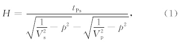
其中,p是射线参数,tPs是Ps震相与直达P波的到时差.由于地壳厚度对Vp/Vs(即κ)的依赖较强(Zhu and Kanamori, 2000),在计算H时,可以用后续的多次震相来作为约束:
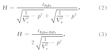
其中,tPpPs是PpPs震相与直达P波的到时差,tPpSs+PsPs是PpSs+PsPs震相与P波的到时差,这样 H和κ就可以被估算出来.Zhu和Kanamori(2000)提出的H-κ格点搜索与叠加方法,是每个H和κ都会对应一个到时,根据到时可以获得其在接收函数中对应的振幅,这些振幅按照公式(4)进行叠加,对在一定范围内的H和κ进行扫描,得到最大振幅的位置,此时S(H,κ)将达到一个最大值,即是求得的地壳厚度H和波速比κ的值.

在邹长桥等(2012)工作基础上,按照每个R分量必须同时具有清楚的直达P、Ps和PpPs三个震相原则,共挑选出1291条高质量的接收函数.参考前人成果(Kind et al., 2002;李永华等,2006),地壳的平均速度为6.2 km·s-1,加权值分别取0.6,0.3和0.1,并做了高程校正,得到49个台站下方的Moho深度点.利用Zhu和Kanamori(2000)误差分析方法得到了本次研究Moho深度误差,大部分误差值小于2 km,结果见表 1所示.
|
|
表 1 台站位置及Moho深度和波速比 Table 1 Locations of broadb and stations and measured Moho depth and Vp/Vs ratio |
图 3给出了NQT24台站下方的接收函数和H-κ扫描结果,清楚的Moho界面的转换震相(Ps)和后续波(PpPs,PpSs+PsPs)表明本次接收函数分析结果可靠.通过插值获得了沿INDEPTH-III剖 面的深度对比(图 4a),显示三者结果较为相近.利用上述挑选的接收函数R分量数据,通过IASPEI91速度模型做了CCP三维叠加成像,并与深反射地震图像(Gao et al., 2013)叠置(图 5).沿东经88.5°下的CCP叠加获得的Moho界面与深地震反射探测获得的Moho反射图像(图 5)在32.6°以南有些差异,可能是因该段范围内没有很好的台站覆盖或者这两种探测方法对台阶状结构的地球物理响应差异所致,但整体上具有较好的一致性.与上述三种不同的地震观测手段获得剖面下的二维Moho变化趋势对比显示,本次研究获得的Moho界面变化特征准确可靠.更因本次研究所用的宽频带地震台站呈面状分布在地质认识争论激烈的羌塘盆地核心区域(图 2),研究区下的Moho三维变化(图 4(b,c))更具有意义.整体而言,图 4显示班公湖—怒江缝合带下(大致32.25°)的Moho存在一个南深北浅断距约 10 km的陡台阶(李永华等,2006;Gao et al., 2013),双湖缝合带(羌塘中央隆起带)下存在一个3 km的Moho台阶.北羌塘地体下的Moho 深度平均在60 km,而南羌塘地体为约63 km.整体上,羌塘下的Moho界面呈近水平.
 |
图 3 台站NQT24下方的接收函数与H-κ扫描结果 (a)NQT24下方的接收函数(R分量),图中Ps与PpPs两组转换震相较为清楚,BAZ为后方位角,RAYP为射线参数;(b)R分量的Slant叠加结果;(c)图a显示接收函数的远震事件分布,主要分布在环印度尼西亚和新西兰一带;(d)H-κ叠加扫描结果.黑十字为H-κ 叠加分析的最大值.未进行海拔高程校正的H-κ叠加扫描结果地壳厚度为63.9 km,对NQT24高程(5.1 km)校正后,位于北羌塘 NQT24台站下方的Moho深度约为58.8 km. Fig. 3 An example of receiver function analysis for station NQT24 in Qiangtang (a)High-quality radial receiver functions. The back azimuths vary from 95° to 205°. Solid circles mark the arrival time of Ps,PpPs and PpSs+PsPs conversions from the Moho,respectively. BAZ means back azimuth RAYP means ray parameter.(b)Slant stacks from all receiver function as shown in(a).(c)The earthquakes distribution(red dots)used in receiver function analysis in(a).(d)H-κ analysis of station NQT24. The black cross indicates the optimal trade-off between the crustal thickness and Vp-to-Vs ratio,the crustal thickness beneath NQT24 is 63.9 km, and after elevation correction(about 5.1 km),Moho depth beneath NQT24 is 58.5 km. |
 |
图 4 羌塘中部莫霍面深度图 (a)来自不同数据和方法的Moho深度对比,红色来自本次研究,绿线来自INDEPTH-III宽频带结果(李永华等,2006)结果,蓝色线来自INDEPTH-III 深地震测深结果(Zhao et al., 2001);(b)综合所有数据编绘的Moho深度图;(c)仅利用本项研究中得到的Moho深度数据 编绘的Moho深度图. Fig. 4 Map of Moho topography in central Qiangtang (a)Comparison of Moho depth from this study with previous results. Data along red line come from this study. Green line is the results from INDEPTH-III_BB by Li et al.(2006). Blue line is Moho depth from INDEPTH-III_DSS(Zhao et al., 2001).(b)Map of Moho topography in central Qiangtang by compilations together with the three datasets as shown in(a).(c)Moho topography in central Qiangtang mapped by use of the data from this study. |
 |
图 5 沿东经88.5°剖面下Moho界面的CCP叠加图像 黄色曲线表示深地震反射Moho(Gao et al., 2013). Fig. 5 CCP image along longitude 88.5°E Yellow line indicates reflection Moho from deep seismic reflection profile(Gao et al., 2013). |
利用H-κ叠加方法不仅能够获得Moho深度数值,而且根据平均的地壳速度,能够方便地给出台站下方的整个地壳尺度的平均Vp/Vs比值.通过其与泊松比的关系获得整个地壳的平均泊松比大小.图 6 给出了研究区内的Vp/Vs比值及泊松比.泊松比的分布特征与INDEPTH-III结果(李永华等,2006)较为相似,而通过区域性分析对比(图 6)给出了较好的构造分区特征,即南羌塘地体内的泊松比 大小为0.31.羌塘中央隆起带下的泊松比平均大小较接近于正常值,为0.27,而北羌塘地体下的泊松比平均为0.28,但在北羌塘地体北部的藏北幔源火山岩区具有较大泊松比.
 |
图 6 羌塘中部Vp/Vs比值(a)及泊松比(b) 黑三角表示INDEPTH-III研究结果(李永华等,2006),空心圆表示本次研究结果. Fig. 6 Ratio of Vp/Vs(a) and Poisson′s ratio(b)in central Qiangtang Black triangles denote those results from INDEPTH-III_BB(Li et al., 2006),hollow circles denote results from this study. |
始于65Ma的印度大陆北向俯冲碰撞(Yin and Harrison, 2000)造就了现今的青藏高原的快速隆升,成为地球上最高的陆地.而羌塘恰位于青藏高原中部(图 1)、较为平坦且平均海拔最高的区域(图 2),是中国境内最大的中、新生代海相盆地(图 2),且具有良好的找油前景(王成善等,2001;赵政璋等,2001;王剑等,2004).然而,由于羌塘中部(双湖区域)的巨厚海相沉积覆盖以及双湖缝合带构造特征至此遁迹,使得对羌塘内部的构造单元组成存在着广泛争议(李才,1987;王成善等,1987;Yin and Harrison, 2000;黄继钧,2001;赵政璋等,2001; Kapp et al., 2003,2008;李才等,2006a;Zhai et al., 2011).沿着88.5°E开展的深地震反射剖面(图 2,Gao et al., 2013)获得的水平Moho使争论愈加强烈,因为Moho不连续界面是判断构造单元的重要依据之一.鉴于本文得到的双湖区域下的Moho地势特征与已有成果(Zhao et al., 2001;李永华等,2006;Gao et al., 2013)具有较好的一致性,表明羌塘双湖区域下的Moho不连续界面较如图 2所示的高原内的其他缝合带更具有特殊的构造意义.
位于羌塘中部的双湖缝合带下的壳幔不连续间断面近水平(图 4)的构造成因可能是以下两个阶段造成的:(1)南羌塘地体与北羌塘地体汇聚过程为一碰撞过程的早期阶段.即,古特提斯洋(李才等,2007)在晚三叠纪关闭后,在南羌塘地体与北羌塘地体间的两个陆块处于碰撞初期阶段时,班公湖—怒江洋在中生代早期(侏罗纪)开始了快速关闭(潘桂棠等,2004),由古特提洋北向消亡过程中诱发的南羌塘地体的北向碰撞减弱甚至停滞,此二者间的碰撞与俯冲并未发生,进而导致了南羌塘地体与北羌塘地体下的Moho初始状态比较平缓.(2)新生代青藏高原快速隆升再调整.即新生代以来的印度大陆板块持续的北向俯冲,其现今的前缘位置已经越过了班公湖—怒江缝合带,大致位于羌塘中央隆起带之下(Chen et al., 2010;He et al., 2010;Hung et al., 2010;Zhang et al., 2012),使得青藏高原快速隆升.在此过程中,羌塘盆地下岩石圈整体上南北向缩短、垂向上隆升,整体上均匀变形调整使得羌塘盆地下的壳幔间不连续间断面(Moho)成近水平.因为,莫霍洛维奇界面(Moho)始终记录并保存了板块构造活动演化过程的最新信息(Meissner,1973).经过这两个比较舒缓的过程使得羌塘下的Moho保持了近水平状.
利用接收函数分析与H-κ叠加能够很容易地估算出Vp/Vs,然后再计算出泊松比.泊松比值能够近似地认为是由于地壳内的物质成分、物理性质及状态引起的.图 6显示羌塘中部的各地质单元的平均趋势.南羌塘地体具有较高的泊松比值0.31,这可能是地壳内的低速层厚度较大所致(李永华等,2006).双湖缝合带下具有正常的泊松比值,大致在0.265左右.尽管北羌塘地体的中南部出露了大面积的岩浆岩露头,如温文尔杂,普若冈日等,但北羌塘地体(34.5°N以北例外)下并不具有高泊松比值,平均为0.285.泊松比具有如此明显的构造分区特征是上述Moho演化的直接例证.而北羌塘地体北缘(34.5°N以北)的高泊松比值则与20 Ma以来的强烈的壳幔相互作用直接相关,即与幔源的藏北钾质火山岩大面积喷发有关. 6 结论
本文分析了布置在羌塘高原中部的54台宽频带地震临时台阵记录的远震地震事件波形,从具有明显清晰的远震P波初至的9532条远震三分量中,挑选出1291条高信噪比的直达P波,Ps波和多次反射波PpPs,PpSs+PsPs等震相清楚的接收函数.通过H-κ叠加方法得到了49个台站下方的Moho深度和平均的Vp/Vs波速比.再通过CCP叠加分析验证了Moho深度数据可靠性.通过与已有资料(深地震反射,深地震测深,宽频带成果,大地电磁探测)综合对比分析,并结合地表地质观察和构造分析,本次研究结论如下:
(1)班公湖—怒江缝合带下(大致32.25°N)的Moho存在一个南深北浅、断距约10 km的陡台阶(李永华等,2006;Gao et al., 2013),双湖缝合带下存在一个3 km的Moho台阶.北羌塘地体下的Moho平均深度约为60 km,而南羌塘地体下约为63 km.整体上,研究区下的Moho界面呈近水平.其构造成因可能是其经历了两个过程:南羌塘地体与北羌塘地体在三叠纪末碰撞,为一碰撞早期阶段,之后新生代青藏高原快速隆升,使得羌塘高原下的Moho进一步调整.
(2)南羌塘地体内的平均泊松比大小为0.31,双湖缝合带下的泊松比的平均大小较接近于正常值,为0.265,北羌塘地体下的泊松比的平均值为0.285,而在北羌塘地体北部泊松比都较大,这与藏北幔源的钾质火山岩大面积喷发有关. 致谢 参加藏北羌塘野外工作的还有中国地质科学院地质研究所卢占武博士,侯贺晟博士,熊小松博士和邓功硕士以及藏族同胞司机师傅们,室内数据处理过程中得到了张洪双博士的帮助,在此一并感谢.
| [1] | Ammon C J. 1991. The isolation of receiver effects from teleseismic P-wave fronts. Bull. Seismol. Soc. Am., 81(6): 2504-2510. |
| [2] | Bao P S, Xiao X C, Wang J. 1999. The blueschist belt in the Shuanghu region, central-northern Tibet and its tectonic implications. Acta Geologica Sinica (in Chinese), 73(4): 302-315. |
| [3] | Chen Y, Badal J, Hu J F. 2010. Love and Rayleigh wave tomography of the Qinghai-Tibet Plateau and surrounding areas. Pure and Applied Geophysics, 167(10): 1171-1203. |
| [4] | Deng W M, Zheng X L,Yukio M. 1996. Petrological characteristics and ages of Cenozoic volcanic rocks from The Hoh XilMts, Qinghai Province. Acta Petrologica Et Mineralogica (in Chinese), 15(4): 289-298. |
| [5] | Gao R, Chen C, Lu Z W, et al. 2013. New constraints on crustal structure and Moho topography in Central Tibet revealed by Sinoprobe deep seismic reflection profiling. Tectonophysics, 606: 160-170, doi: 10.1016/j.tecto.2013.08.006. |
| [6] | He R Z, Zhao D P, Gao R, et al. 2010. Tracing the Indian lithospheric mantle beneath central Tibetan plateau using teleseismic tomography. Tectonophysics, 20(1-4): 230-243, doi: 10.1016/j.tecto.2010.03.015. |
| [7] | He R Z, Gao R, Hou H S, et al. 2009. Deep structure of the central uplift belt in the Qiangtang terrane, Tibet Plateau from broadband seismic observations and its implications. Progress in Geophysics (in Chinese), 24(3): 900-908. |
| [8] | Huang J J. 2001. Tectonic characteristics and evolution of the Qiangtang basin. Regional Geology of China (in Chinese), 20(2): 178-186. |
| [9] | Hung S H, Chen W P, Chiao L Y, et al. 2010. First multi-scale, finite-frequency tomography illuminates 3-D anatomy of the Tibetan Plateau. Geophys. Res. Lett., 37(6): L06304, doi: 10.1029/2009GL041875. |
| [10] | Kapp P, Yin A, Manning C E, et al. 2000. Blueschist-bearing metamorphic core complexes in Qiangtang block reveal deep crustal structure of northern Tibet. Geology, 28(1): 19-22, doi: 10.1130/0091-7613(2000)28〈19:BMCCIT〉2.0.CO;2. |
| [11] | Kapp P, Yin A, Manning C E, et al. 2003. Tectonic evolution of the early Mesozoic blueschist bearing Qiangtang metamorphic belt, central Tibet. Tectonics, 22(4): 1043, doi: 10.1029/2002 TC001383. |
| [12] | Kapp P, Taylor M, Stockli D, et al. 2008. Development of active low-angle normal fault systems during orogenic collapse: Insight from Tibet. Geological Society of America, 36(1): 7-10, doi: 10.1130/G24054A.1. |
| [13] | Kind R, Vinnik L P. 1988. The upper mantle discontinuities underneath the GRF array from P to S converted phases. J. Geophys., 62: 138-147. |
| [14] | Kind R, Yuan X, Saul J, et al. 2002. Seismic images of crust and upper mantle beneath Tibet: Evidence for Eurasian plate subduction. Science, 298(5596): 1219-1221, doi: 10.1126/science.1078115. |
| [15] | Kosarev G, Kind R, Sobolev S V, et al. 1999. Seismic evidence for a detached Indian lithospheric mantle beneath Tibet. Science, 283(5406): 1306-1309. |
| [16] | Langston C A. 1977. Corvallis, Oregon, crustal and upper mantle receiver structure from teleseismic P and S waves. Bull. Seism. Soc. Am., 67(3): 713-724. |
| [17] | Li C. 1987. The Longmucuo-Shuanghu-Lanchangjiang plate suture and the north boundary of distribution of Gondwana facies Permo-Carboniferous system in Northern Xizang, China. Journal of Changchun College of Geology (in Chinese), 17(2): 155-166. |
| [18] | Li C, Cheng L R, Hu K, et al. 1995. Ice-Sea Mix-Conglomerates and their genesis in the southern area of Qiangtang, Tibet. Journal of Changchun University of Earth Sciences (in Chinese), 25(4): 368-374. |
| [19] | Li C, Wang T W, Yang D M, et al. 2001. The lithological composition and tectonic evolution of Qiangtang central uplift region, Tibet. Journal of Changchun University of Science and Technology (in Chinese), 31(1): 25-31. |
| [20] | Li C, Huang X P, Zhai Q G, et al. 2006a. The Longmu Co-Shuanghu-Jitang plate suture and the northern boundary of Gondwanaland in the Qinghai Tibet plateau. Earth Science Frontiers (in Chinese), 13(4): 136-147. |
| [21] | Li C, Zhai Q G, Chen W, et al. 2006b. Ar-Ar chronometry of the eclogite from central Qiangtang area, Qiangtang-Tibet Plateau. Acta Petrologica Sinica (in Chinese), 22(12): 2843-2849. |
| [22] | Li C, Zhai Q G, Dong Y S, et al. 2006c. The discovery of the eclogites in Qiangtang area, Tibet. Chinese Science Bulletin (in Chinese), 51(1): 70-74. |
| [23] | Li C, Zhai Q G, Dong Y S, et al. 2007. Longmu Co-Shuanghu plate suture in the Qinghai-Tibet plateau and records of the evolution of the Paleo-Tethys Ocean in the Qiangtang area, Tibet, China. Geological Bulletin of China (in Chinese), 26(1): 13-21. |
| [24] | Li T D, Geng S F, Fan B X, et al. 2006. 1:2500000 Geological Maps of the Western Part of China and Its Adjacent Region. Beijing: China Geosciences Press. |
| [25] | Li Y H, Tian X B, Wu Q J, et al. 2006. The poisson ratio and crustal structure of the central Qinghai-Xizang inferred INDEPTH-III teleseismic waveforms: Geological and geophysical implications. Chinese J. Geophys. (in Chinese), 49(4): 1037-1044. |
| [26] | Lu Z W, Gao R, Xue A M, et al. 2006. New seismic reflection profiles and basement structure in the Qiangtang basin, northern Tibet. Geology in China (in Chinese), 33(2): 286-290. |
| [27] | Lu Z W, Gao R, Li Q S, et al. 2009. Testing deep seismic reflection profiles across the central uplift of the Qiangtang terrane in the Tibetan Plateau. Chinese J. Geophys. (in Chinese), 52(8): 2008-2014. |
| [28] | Lu Z W, Gao R, Li Y T, et al. 2013. The upper crustal structure of the Qiangtang Basin revealed by seismic reflection data. Tectonophysics, 606(23): 171-177, doi: 10.1016/j.tecto.2013.07.019. |
| [29] | Meissner R. 1973. The 'Moho’ as a transition zone. Surveys in Geophysics, 1(2): 195-216. |
| [30] | Owens T J, Zandt G, Taylor S R. 1984. Seismic evidence for an ancient rift beneath the Cumberland Plateau, Tennessee: A detailed analysis of broadband teleseismic P waveforms. Journal of Geophysical Research, 89(B9): 7783-7795. |
| [31] | Pan G T, Zhu D C, Wang L Q, et al. 2004. Bangong Lake-Nu River suture zone-the northern boundary of Gondwana land: evidence from geology and geophysics. Earth Science Fronties (in Chinese), 11(4): 371-382. |
| [32] | Sengor A M C. 1990. Plate tectonics and orogenic research after 25 years: A Tethyan perspective. Earth-Science Reviews, 27(1-2): 1-201. |
| [33] | Tian Q N, Geng T, Yang H Q, et al. 2008. Gravity anomalies forward fitting and geological explanation in the western Qinghai Tibet Plateau. Geological Bulletin of China (in Chinese), 27(12): 2108-2116. |
| [34] | Tilmann F, Ni J, INDEPTH III Seismic Team. 2003. Seismic imaging of the downwelling Indian lithosphere beneath central Tibet. Science, 300(5624): 1424-1427, doi: 10.1126/science.1082777. |
| [35] | Wang C S, Hu C Z, Wu R Z, et al. 1987. Significance of the discovery of Chasang-Chabu rift in Northern Xizang (Tibet). Journal of Chengdu College of Geology (in Chinese), 14(2): 33-46. |
| [36] | Wang C S, Yin H S, Li Y, et al. 2001. Geological Evolution of Qiangtangbasin in Tibet and Its Oil and Gas Exploration Prospects (in Chinese). Beijing: Geological Publication House. |
| [37] | Wang J, Tan F W, Li Y L, et al. 2004. Potential Petroleum Resources Analysis of Key Basins in Qinghai-Tibet Plateau (in Chinese). Beijing: Geological Publishing House. |
| [38] | Wang X C, Jia J X, Xu B C. 2008. Analog interpretation of composite geophysical profile on tectonics of Qiangtang basin. Global Geology (in Chinese), 27(1): 76-82. |
| [39] | Wei W B, Jin S, Ye G F, et al. 2006. Conductivity structure of crust and upper mantle beneath the northern Tibetan Plateau: Results of super-wideband magnetotelluric sounding. Chinese J. Geophys. (in Chinese), 49(4): 1215-1225. |
| [40] | Yin A, Kapp P A, Murphy M A, et al. 1999. Significant Late Neogene East-West Extension in Northern Tibet. Geology, 27(9): 787-790. |
| [41] | Yin A, Harrison T M. 2000. Geologic evolution of the Himalayan-Tibetan Orogen. Earth Planet Sci., 28: 211-280, doi: 10.1146/annurev.earth.28.1.211. |
| [42] | Yuan S C, Yu G M, Tian Q N. 2007. Gravity and magnetic anomaly profiles and characteristics of basement structure in the Qiangtang basin. Geological Bulletin of China (in Chinese), 26(6): 703-709. |
| [43] | Zhai Q G, Zhang R Y, Jahn B M, et al. 2011. Triassic eclogites from central Qiangtang, northern Tibet, China: Petrology, geochronology and metamorphic P-T-t path. Lithos, 125(1): 173-189, doi: 10.1016/j.lithos.2011.02.004. |
| [44] | Zhang H, Zhao D P, Zhao J M, et al. 2012. Convergence of the Indian and Eurasian plates under eastern Tibet revealed by seismic tomography. Geochem. Geophys. Geosyst., 13(6): 1-11, doi: 10.1029/2012GC004031. |
| [45] | Zhang K J, Zhang Y X, Li B, et al. 2006. The blueschist-bearing Qiangtang metamorphic belt (northern Tibet, China) as an in situ suture zone: Evidence from geochemical comparison with the Jinsa suture. Geology, 34(6): 493-496, doi: 10.1130/G22404.1. |
| [46] | Zhao W, Mechie J, Brown L D, et al. 2001. Crustal structure of the central Tibet as derived from project INDEPTH wide-angle seismic data. Geophys. J. Int., 145(2): 486-498, doi: 10.1046/j.0956-540x.2001.01402.x. |
| [47] | Zhao Z Z, Li Y T, Guo Z J, et al. 1997. Oil and gas exploration prospects for Tibetan plateau. Petroleum Explorationist (in Chinese), 2(3): 14-16. |
| [48] | Zhao Z Z, Li Y T, Ye H F, et al. 2001. Mesozoic Sedimentary Facies and Characteristics of Reservoir and Seal Rocks in Qinghai-Xizang Plateau (in Chinese). Beijing: Science Publication House. |
| [49] | Zhu L P, Kanamori H. 2000. Moho depth variation in southern California from teleseismic receiver functions. J. Geophys. Res., 105(B2): 2969-2980, doi: 10.1029/1999JB900322. |
| [50] | Zou C Q, He R Z, Gao R, et al. 2012. Deep structure of the central uplift belt in the Qiangtang terrane, Tibetan plateau, from teleseismic P-wave tomography. Chinese Science Bulletin (in Chinese), 57(28-29): 2729-2739. |
| [51] | 鲍佩声, 肖序常, 王军. 1999. 西藏中北部双湖地区蓝片岩带及其构造涵义. 地质学报, 73(4): 302-315. |
| [52] | 邓万明, 郑锡澜, 松本征夫. 1996. 青海可可西里地区新生代火山岩的岩石特征与时代. 岩石矿物学, 15(4): 289-298. |
| [53] | 贺日政, 高锐, 侯贺晟等. 2009. 羌塘中央隆起带深部结构特征研究及其意义. 地球物理学进展, 24(3): 900-908, doi: 10.3969/j.issn.1004-2903.2009.03.012. |
| [54] | 黄继钧. 2001. 藏北羌塘盆地构造特征及演化. 中国区域地质, 20(2): 178-186, doi: 10.3969/j.issn.1671-2552.2001.02.011. |
| [55] | 李才. 1987. 龙木错—双湖—澜沧江板块缝合带与石炭—二叠纪冈瓦纳北界. 长春地质学院学报, 17(2): 155-166. |
| [56] | 李才, 程立人, 胡克等. 1995. 西藏羌塘南部地区的冰海杂砾岩及其成因. 长春地质学院学报, 25(4): 368-374. |
| [57] | 李才, 王天武, 杨德明等. 2001. 西藏羌塘中央隆起区物质组成与构造演化. 长春科技大学学报, 31(1): 25-31, doi: 10.3969/j.issn.1671-5888.2001.01.005. |
| [58] | 李才, 黄小鹏, 翟庆国等. 2006a. 龙木错-双湖-吉塘板块缝合带与青藏高原冈瓦纳北界. 地学前缘, 13(4): 136-147, doi: 10.3321/j.issn:1005-2321.2006.04.011. |
| [59] | 李才, 翟庆国, 陈文等. 2006b. 青藏高原羌塘中部榴辉岩Ar-Ar定年. 岩石学报, 22(12): 2843-2849, doi: 10.3321/j.issn:1000-0569.2006.12.003. |
| [60] | 李才, 翟庆国, 董永胜等. 2006c. 青藏高原羌塘中部榴辉岩的发现及其意义. 科学通报, 51(1): 70-74, doi: 10.3321/j.issn:0023-074X.2006.01.01. |
| [61] | 李才, 翟庆国, 董永胜等. 2007. 青藏高原龙木错-双湖板块缝合带与羌塘古特提斯洋演化记录. 地质通报, 26(1): 13-21, doi: 10.3969/j.issn.1671-2552.2007.01.003. |
| [62] | 李廷栋, 耿树方, 范本贤等. 2006. 1:250万中国西部及邻区地质图. 北京: 中国地质出版社. |
| [63] | 李永华, 田小波, 吴庆举等. 2006. 青藏高原INDEPTH-III剖面地壳厚度与泊松比: 地质与地球物理含义. 地球物理学报, 49(4): 1037-1044, doi: 10.3321/j.issn:0001-5733.2006.04.015. |
| [64] | 卢占武, 高锐, 薛爱民等. 2006. 羌塘盆地石油地震反射新剖面及基底构造浅析. 中国地质, 33(2): 286-290, doi: 10.3969/j.issn.1000-3657.2006.02.006. |
| [65] | 卢占武, 高锐, 李秋生等. 2009. 横过青藏高原羌塘地体中央隆起区的深反射地震试验剖面. 地球物理学报, 52(8): 2008-2014, doi: 10.3969/j.issn.0001-5733.2009.08.008. |
| [66] | 潘桂棠, 朱弟成, 王立全等. 2004. 班公湖-怒江缝合带作为冈瓦纳大陆北界的地质地球物理证据. 地学前缘, 11(4): 371-382, doi: 10.3321/j.issn:1005-2321.2004.04.004. |
| [67] | 田黔宁, 耿涛, 杨汇群等. 2008. 青藏高原西部重力异常剖面拟合及其地质解释. 地质通报, 27(12): 2108-2116, doi: 10.3969/j.issn.1671-2552.2008.12.018. |
| [68] | 王成善, 胡承祖, 吴瑞忠等. 1987. 西藏北部查桑—茶布裂谷的发现及其地质意义. 成都地质学院学报, 14(2): 33-46. |
| [69] | 王成善, 伊海生, 李勇等. 2001. 西藏羌塘盆地地质演化与油气远景评价. 北京: 地质出版社. |
| [70] | 王剑, 谭富文, 李亚林等. 2004. 青藏高原重点沉积盆地油气资源潜力分析. 北京: 地质出版社. |
| [71] | 王喜臣, 贾建秀, 徐宝慈. 2008. 羌塘盆地综合地球物理剖面的模拟解释. 世界地质, 27(1): 76-82, doi: 10.3969/j.issn.1004-5589.2008.01.015. |
| [72] | 魏文博, 金胜, 叶高峰等. 2006. 藏北高原地壳及上地幔导电性结构—超宽频带大地电磁测深研究结果. 地球物理学报, 49(4): 1215-1225, doi: 10.3321/j.issn:0001-5733.2006.04.038. |
| [73] | 苑守成, 于国明, 田黔宁. 2007. 青藏高原羌塘盆地重磁剖面异常与基底构造特征. 地质通报, 26(6): 703-709, doi: 10.3969/j.issn.1671-2552.2007.06.011. |
| [74] | 赵政璋, 李永铁, 郭祖军等. 1997. 青藏高原油气勘探前景. 勘探家, 2(3): 14-16. |
| [75] | 赵政璋, 李永铁, 叶和飞等. 2001. 青藏高原中生界沉积相及油气储盖层特征. 北京: 科学出版社. |
| [76] | 邹长桥, 贺日政, 高锐等. 2012. 远震p波层析成像研究羌塘中央隆起带深部结构. 科学通报, 57(28-29): 2729-2739, doi: 10.1360/972011-2430. |