扩展功能
文章信息
- 陈洪德, 侯明才, 陈安清, 时志强, 邢凤存, 黄可可, 刘欣春
- CHEN HongDe, HOU MingCai, CHEN AnQing, SHI ZhiQiang, XING FengCun, HUANG KeKe, LIU XinChun
- 中国古地理学研究进展与关键科学问题
- Advances and the Major Scientific Issues of the Paleogeography in China
- 沉积学报, 2017, 35(5): 888-901
- ACTA SEDIMENTOLOGICA SINCA, 2017, 35(5): 888-901
- 10.14027/j.cnki.cjxb.2017.05.003
-
文章历史
- 收稿日期:2017-07-06
- 收修改稿日期: 2017-08-28
2. 成都理工大学沉积地质研究院, 成都 610059
2. Institute of Sedimentary Geology, Chengdu University of Technology, Chengdu 610059, China
古地理(Paleogeography或Palinspastic)概念最早来自Sterry[1],被定义为利用古植物学和古动物学系统研究地质历史时期的地理学科。随后,定义为古生物地理学(Paleobiogeography)[2]。早期的古地理概念强调古环境[1-2]。直到Wegener[3]提出著名的大陆漂移学说以后才使得古地理具有了真正的活动含义。其研究范畴得到了大大的拓展,越来越多的地质科学家加入其中。古地理学逐渐成为了地质学的重要分支,其内涵为研究地质历史时期地球表面的自然地理,既描述地球过去的大陆轮廓、纬度、地形起伏、气候、生物等,也对岩石圈、大气圈、生物圈和水圈历史面貌进行综合研究,涉及古生态、古环境、古气候、古海洋以及古生物等方面,是一门综合性的地球科学。如根据化石的性质,推测生物原先栖居的环境;根据沉积岩的成分、粒度和结构,推测当时水盆地的地形形态和深度;根据古地磁学的研究,判断岩石形成时的古纬度和古地磁极的变化;用同位素方法推测古海洋温度等。相应的古地理图则是对某个时期某个范围内各种地质地理现象特征的具体体现。古地理重建的意义在于:1) 反演地球表面系统过去的状态,为地质学、地理学、海洋学和气候学等研究提供了一个理想的框架约束;2) 更好地认识现代地理环境的本质特征,预测未来地理环境演变的趋势,并提出合理利用、改造环境的科学对策;3) 对某一地质时期某个地区的古地理研究(如古地貌、古水深、古水温、古咸度、古水化学成分、沉积物组成、粗细变化、搬运方向等要素),有助于揭示油气、煤矿、铀矿和有关的残积风化矿床以及地下水等矿产资源的成矿规律、形成条件和分布规律,指导矿产资源勘探预测及开发。
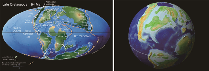
2 国际古地理学研究进展国外古地理学研究主要侧重全球板块尺度的重建,先后经历了前板块构造理论期和板块构造理论期。前板块构造理论期,即第一代古地理图编图时期,可追溯到19世纪末Suess[4-5]提出的特提斯洋和冈瓦纳大陆。Haug(1900) 编制了标有非洲—巴西古大陆—澳大利亚—印度—马达加斯加古大陆的世界地图,拉开了古地理重建的大幕。最具有跨越意义的是Wegener[3]提出了大陆漂移学说,诞生了第一张泛大陆古地理再造图。第一代古地理编图主要基于地层学、古生物学的资料[6],缺乏足够的定量证据约束。特别是对于大陆漂移理论,诸多学者强烈反对[7-9],因此可以说是在争议中渡过的。板块构造理论期,即第二代活动古地理图编图时期,具有精确定位作用的古地磁学的广泛应用,加上深部地球物理揭示板块构造动力机制(如地体构造的提出增进了对造山带和大陆地壳生长的理解),使板块构造理论在争议中被大量科学证据证实而大获全胜[10-16],促进了古地理研究实现了飞越,实现了古地理重建从定性推断进入精确定量约束阶段。多个国际团队利用多学科的定量和定性双重约束重建了不同时期的全球活动古地理图,标志着古地理重建得到了蓬勃发展。美国科学家Scotese教授领导的“PALEOMAP Project”是当今最为系统和代表性的全球古地理重建工程,重建了1 100 Ma以来的洋、陆分布及盆地的板块构造演化(图 1),并通过系列彩色的二维和三维古地理图件展示出了古陆高程、古岸线和古气候带的变迁,还预测了未来板块的位置,形成了公开的数据库及互联网展示平台(具体参见http://www.scotese.com)。
|
| 图 1 全球晚白垩世古地理二维(左)、三维(右)重建实例(引自Scotese,http://www.scotese.com) Figure 1 An example of global 2D (left) and 3D palaeogeography reconstruction (right) of late Cretaceous (from Scotese, http://www.scotese.com) |
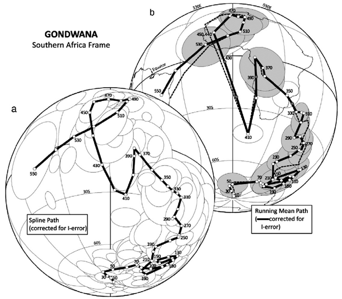
目前,国际上古地理的研究除了传统意义上的不同尺度的古地理编图外[17],逐渐从地球时间(ET)尺度来分析古地理的变迁,逐渐将构造、地形地貌、气候变化、盆山耦合、源汇系统、汇水盆地特征、古生物、古海洋等融入到古地理研究之中[18-19]。如今,地球内部的动力学系统与古大陆、古构造域的地理变迁的耦合关系越来越受到重视,如Grenville造山运动—陆陆碰撞、Rodinia超大陆新的重建[20]、特提斯构造域东特提斯、Gondwana大陆等的形成演化及动力学过程(图 2)[21-26]。古地理变迁过程中表生系统的全球性或地区性事件成为研究热点,全球性气候变暖事件、全球成冰事件、大洋缺氧和富氧事件,地区性的如飓风事件、洪水事件、地震事件、火山事件[27-31]。特别是古地理变迁中的生命效应的研究不断深入,如P/T生物灭绝事件[32-33]。
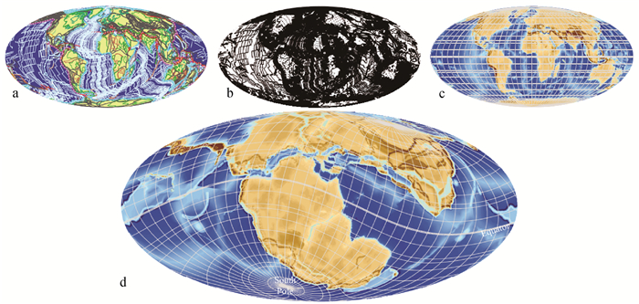
在研究方法上,传统方法不断完善,岩相学[34]、古物源和古流向[35]、重矿物分析[36]、黏土矿物分析[37-38]等用来恢复沉积环境、古气候变化、源汇系统、海平面变化和海岸地貌变化。高新、高精度的分析测试技术不断引入,地球化学方法[21, 39]、古地磁学方法[34, 40-41]、古生物学方法[42-43]、定年方法[34]、纳米级的岩矿分析技术、元素扫描技术、微区矿物分析技术、QEMSCAN矿物定量分析技术等被不断引入。地球物理数据与方法(高精度的三维地震地层学、地震地貌学和地震沉积学)等对盆地内地层埋藏区古地理重建起着越来越重要的作用。实验和模拟技术不断提高,如水槽实验、深水沉积作用观测、3D古地理重建技术(图 3)、数学模拟技术[45]等。除此之外,还包括利用一些特殊方法来进行古地理重建,如Becker-Haumann[31]基于地形参数,通过GIS的3D模拟技术对阿尔卑斯山脉的Molasse前陆盆地开展了河流阶地地形沉积的模拟,进而为古地理研究提供依据;Dewever et al.[46]通过喀斯特地区古水流的重建,系统分析了西西里岛北部—中部白垩纪Sicilian褶皱和冲断带的构造演化过程。古地理研究中等时性对比分析逐渐丰富和完善,除了同位素年代学、化学地层学、生物地层学以及层序地层学起到了重要的作用外,旋回地层学促进了地质定年从过去某个界面的瞬时年龄,发展到如今地质持续年龄轴逐渐被建立[47],这对全时古地理恢复和古地理细节的揭露至关重要。
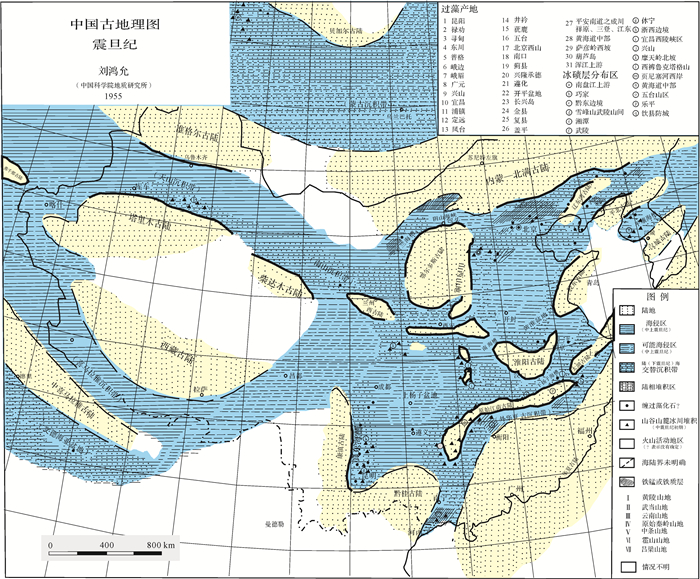
3 中国古地理学研究进展及特色早期的古地理图是建立在地球固定论概念基础上的,着重于海陆分布形态变化特征的描绘。中国古地理图最早见于20世纪30年代葛利普[48]的《中国地质史》。限于当时的资料条件,该书的少数几幅古地理图所涉及的国土范围较小,内容局限于几个地质时代的海陆分布,然而对于后来的古地理研究却具有重要启蒙意义。之后,Huang[49]出版了有划时代意义的经典性著作On Major Tectonic Forms of China中以大地构造与古地理相结合,编制有寒武纪、泥盆纪、二叠纪、白垩纪和喜马拉雅山期的中国古地理图5幅。20世纪50年代中期,刘鸿允[50]以古生物地层学方法编制的《中国古地理图》(图 4),是第一本系统论述我国各地质时代沉积地层的古地理轮廓专著,具有开创意义。20世纪60年代中期,卢衍豪等[51]以古生物学的观点和资料出发,并适当配以简单的岩性,编制出以“组”为单位的8幅中国寒武纪岩相古地理图。
60年代晚期板块构造理论的建立及其70年代全球范围的成功推广,反映了当时地学革命的主流,也使得古地理图编图思路发生相应转变,把古地理学推上了新的发展阶段。自20世纪70年代后期至今,以冯增昭先生为代表,采用单因素分析多因素综合作图法先后编制了下扬子地区中下三叠世青龙群岩相古地理图和中国南方早中三叠世岩相古地理图等一系列的岩相古地理图,这一方法的核心是定量化,引领了定量古地理编图的发展[52-54]。20世纪80年代早期,关士聪[55]完成并出版了《中国海陆变迁、海域沉积相与油气》一书。该书列出了中国中—晚元古代(长城纪—震旦纪)到三叠纪海陆分布及海域沉积相图20幅,海陆变迁图5幅,着重论述了海陆变迁、海域沉积相与油气的关系,并试图探讨中国海相油气远景。同年出版的《中国自然地理》中崔克信[56]编撰的古地理分册的下册中以“构造运动为纲”的思路编制了8幅小比例尺不同地壳运动时期的海陆分布图,断代的晚元古代震旦纪、早古生代和晚古生代古地理图各一幅。
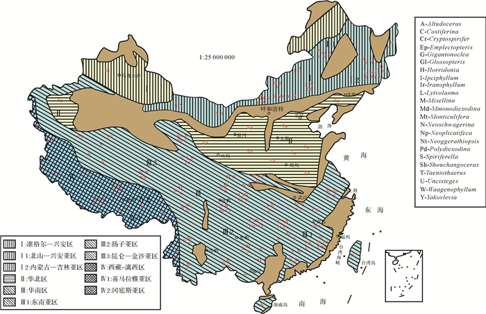
在全球构造的“活动论”与历史演化的“阶段论”有机结合的思想主导下,王鸿祯[57]编制了《中国古地理图集》,包括古地理图、古构造图、生物地理图、气候分带图等系列图件(图 5)。之后,王鸿祯等[58]又出版了《中国及邻区古生代生物古地理及全球古大陆再造》,不但再次充分体现了构造古地理和生物古地理研究成果,也包括岩相古地理内容,系统地表达了对中国地壳在地质历史中的地理发展和构造演变基本过程。刘鸿允[59]在《中国震旦系》一书中,详细讨论了震旦系古构造特征及古地理沉积演化,并编制了当时国内相同时期最为详尽、与已出版的其他相同时代的图件有很大不同的中国早震旦世、晚震旦世南华大冰期和陡山沱期纪灯影期岩相古地理图。
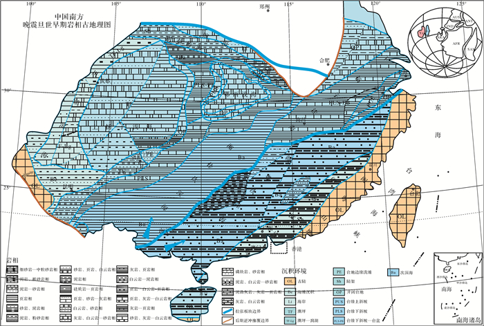
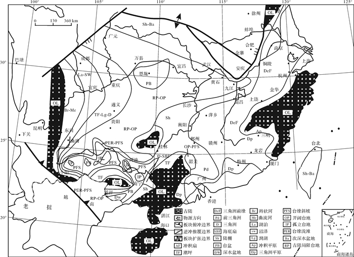
1985年,刘宝珺等[60]出版了《岩相古地理基础和工作方法》教程,标志着我国岩相古地理学已成为沉积地质学的重要分支。之后,刘宝珺等[61]又出版了《中国南方岩相古地理图集》(图 6),全面阐述了中国南方板块沉积地壳的活动史、沉积史、封闭史和成矿史;突出了盆地分析和盆地演化、事件和成矿作用;恢复和重建了不同地质历史时期的古地理单元;重建了古海洋和古大陆的变迁,建立了动力演化模式;把沉积—构造—成矿看成是盆地地质作用统一体,提出了“盆、相、位”三位一体和“统一地质场”的成矿理论,开拓了新的找矿思路;体现了“构造控制盆地、盆地控制沉积”和构造活动论思想,具有综合性、系统性和全球性,是我国的第三代岩相古地理图。
李思田[62]含煤盆地岩相古地理编图研究是以服务于某种矿产勘探的应用古地理研究的典范。应用古地理的研究也是我国的一大特色,如近年来页岩气的勘探需求正催生了深水细粒沉积区古地理研究[63-64]。
值得一提的是,层序—岩相古地理在我国的广泛应用。Vail et al.[65]提出的层序地层学理论从四维时空认识沉积体,不仅把时间界面、全球海平面升降、构造沉降、气候和沉积物供应有机地联系起来,而且将岩石地层、生物地层统一于地质年代格架内,从而可以比较真实地再现沉积盆地各演化时期的沉积物来源、构造沉降、沉积充填过程及古气候的相互关系, 1994年,陈洪德等[66]在《层序地层学理论和研究方法》一书中,首先在我国提出了层序—岩相古地理编图理论和方法。王成善等[67]以层序地层学理论为基础,首次按层序的体系域编制了层序—岩相古地理图(图 7)。以层序或体系域为编图单元编制古地理图件,不仅是年代地层段和等时地质体,且其顶、底是可确定的物理界面。之后,马永生等[68]在刘宝珺和曾允孚先生的指导下,运用这一思路将构造、层序与岩相古地理有机结合,历经十年组织近百位专家与研究人员研究编制出版了《中国南方构造—层序岩相古地理图集》,以层序的动态充填过程为主线,揭示了盆地的构造—层序岩相古地理演化,更接近盆地沉积演化的真实性。此后,陈洪德等[69-70]进一步提出了不同级次的层序—岩相古地理编图理论与方法,着眼于不同层次的沉积矿产勘探,对油气勘探具有重要指导意义。无独有偶,以Cross[71]提出高分辨率层序地层学理论为指导,郑荣才等[72]、邓宏文[73]等利用基准面旋回为时间轴的高分辨率层序—岩相古地理研究是以相域和短时间尺度层序为编图单元编制岩相古地理图,也在我国的油气勘探研究中得到了广泛的应用。
随着编图理论的不断革新,不同研究者不断改进自己的观点和方法,但仍存在共同的不足:一是怎样编制反映活动论的岩相古地理图;二是怎样反映特定时间间隔内某地区的四维古地理演化史。何登发等[74]以盆地原型分析为理论基础,注重盆地的复原与复位研究,编制盆地尺度的构造盆地古地理,恢复盆地发展某一个阶段(某一构造层的形成时间)有相对稳定的大地构造环境的盆地实体,包括恢复沉积充填组合、地理环境、盆地边界、盆地性质、盆地改造过程、成盆动力等。造山带作为盆地的孪生姐妹,Wang et al.[75],王成善等[76]开展了卓有成效的造山带古地理研究。以青藏高原为研究对象,其古地理研究的材料不再局限于沉积岩,而系统地将沉积学(包括沉积岩石学、古生物学、沉积地球化学等)、变质岩石学、岩浆岩岩石学、构造地质学和地球物理学等多学科交叉结合,研究高原隆升带来的全球尺度的地理、气候、环境效应,并力图回答高原隆升过程中地球深部过程和地球表面系统的耦合机制。
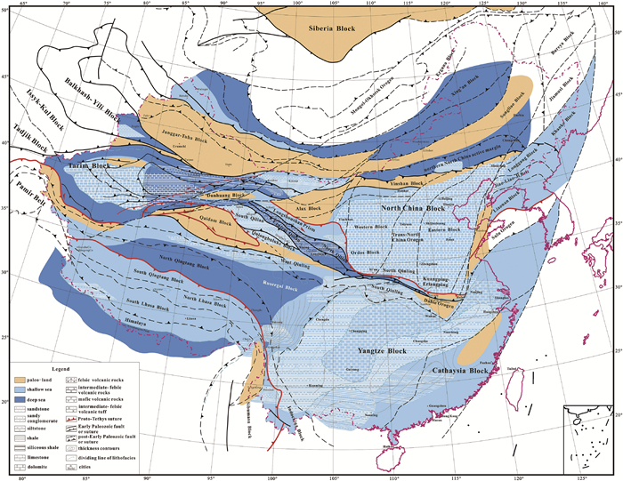
在板块构造古地理重建方面,许效松等[77]重建了中国各陆块在显生宙几个主要时段的相对位置分布,探讨了四川盆地、鄂尔多斯盆地和塔里木盆地的古地理环境特征和油气资源效应;万天丰等[78]根据中国大陆及邻区的古生代和三叠纪古地磁数据,复原了中国各陆块在全球大陆中的位置,探讨了它们的运动学特征,但未开展古地理研究。李江海等[79]在《全球古板块再造、岩相古地理及古环境图集》中系统地绘制了古板块再造图、古地理环境恢复图、沉积岩相图、烃源岩分布图、主要古生物分布图等系列图件。近期,Li et al.[80]开展了系列的有关原特提斯洋关闭和东亚微陆块群聚合的研究,既有对主要造山带演化细节的构造约束研究,也有对岩相分布的编图(图 8)。但这些板块构造古地理研究缺乏盆地古地理环境和地质事件的信息。近几年,在中国地质调查局的资助下,实施了“中国西部主要大型盆地碳酸盐岩油气勘探新领域及战略选区”大型地质调查与研究项目,涉及的盆地包括四川、鄂尔多斯、塔里木盆地。项目组系统开展了三个盆地的盆地岩相古地理重建编图与研究,揭示出了我国克拉通盆地深层海相地层古地理的诸多新面貌,如对上扬子寒武纪陆内拉张槽的发现和刻画。同时,初步形成了盆地岩相古地理编图标准化和数据库建设的方案,包括古地理图的标准图例、比例尺、沉积相分类标准、各类基础图件、各种数据的数据库汇编规范等。
总的来说,板块构造古地理在我国正悄然发展,但仍比较薄弱,我国大部分的古地理研究人员都侧重于中国及邻区的岩相古地理编图,以服务于矿产资源为主,即我国古地理编图研究主体上是以资源勘探为导向的应用古地理。应用古地理研究在我国得到了蓬勃发展,并且不断往更小的空间尺度和时间尺度的精细岩相古地理编图的方向发展。
4 中国古地理学研究的重大关键科学问题及未来的发展方向尽管我国古地理学研究经过数十年的发展已取得广泛而深入的进展。但一方面,中国小板块多旋回叠合演化的特色造成了板块重建和盆地恢复的复杂性;另一方面,虽然应用古地理在我国蓬勃发展,但基于重大科学问题为导向的古地理系统工程较少。前寒武纪板块构造体制之前的古地理研究仍处于探讨和假说阶段。从目前的研究现状看:首先,中国古地理缺乏系统性研究,没有形成有国际影响力的大科研团队;其次,中国古地理演变过程以前着重关注扬子、华北和塔里木板块,没有系统的囊括众多陆块群的古地理重建;再次,对中国小陆块群重大聚散期的机制及古地理效应的研究不够。中国陆块群显生宙所处的古地理位置和独特的沉积地层,对于揭示地球重大古地理变迁的细节和机制意义重大,面临诸多亟待解决的重大关键科学问题:
(1) 中国小陆块群聚散的古地理演变过程
中国板块构造具有小板块拼合、多旋回叠合演化的特色,当今又具有世界屋脊青藏高原和黄土高原两大独特的地貌单元,这些重大构造、地貌为中国独有。小板块拼合前后的古地理面貌巨变过程及机制仍有诸多问题悬而未决。如扬子板块与华北板块拼合形成了中央造山带——东秦岭—大别山造山带,虽然关于两者如何碰撞[81-82]及碰撞的时间还存在着争论[83],但其造成华南板块和华北板块成为统一大陆,古秦岭洋最终闭合以及古特提斯洋海水完全退去[83-88],到晚三叠世南北秦岭已发育陆相沉积而转入新的演化阶段[81, 87-88]。这一构造事件伴随着海陆变迁的发生[86],控制着四川、鄂尔多斯等多个沉积盆地古地理环境甚至古气候的变化,进而制约了沉积盆地油气、煤、铀等多种矿产资源的形成与分布。白垩纪以来中国地势由东高西低转变为西高东低带来了古地理沧海桑田变化。中国东部古高原可能在170 Ma之前开始出现(华北北部可能在165 Ma之前),在晚侏罗世高原范围达到最大,早白垩世高原从边部开始垮塌[89-90]。如在辽西—冀北地区晚侏罗世末期以挤压构造为主,而早白垩世以伸展构造为特征,古地理古环境明显改变[91-92]。及至新生代,伴随着青藏高原的阶段性隆升[93-98]以及太平洋板块与亚洲板块碰撞造就的中国东部伸展性构造发育[99-103],中国的古地势发生反转。最为典型的古地理效应是青藏高原的隆升和中国现今构造地貌格架的形成直接影响了中国和全球气候环境的变迁[104],如盛行于超大陆的超级季风在白垩纪解体[105-106],代之以东亚季风,由此造成中国的古气候的巨变。虽然青藏高原隆升及其地理环境效应是当前的研究热点,目前亟需拓展研究白垩纪以来的中国东西部地势反转过程的机制及其深时古地理效应。
(2) 重大生命环境事件的关键古地理指标
地球生命自38亿年前诞生之后经历了多次生命环境突变事件。突出表现在生物大辐射和大灭绝事件。距今约20亿年前的地球大氧化作用,导致了真核生命的出现,使得生物的多样性第一次获得快速的发展。第二次大氧化事件,迎来了多细胞后生生物的大发展,并在寒武纪呈现了爆发式的大辐射。寒武纪演化生物群,奠定了现代生物门类的整体框架和多样性发展的基础。奥陶纪演化生物群引领了古生代生物群的发展。中新生代生命演化形成了现代生物群。地球生物进化既有高潮,也有低潮。显生宙以来地球生物发生了五次大规模生物集群灭绝事件。第一次大灭绝出现在距今4.4亿年前的奥陶纪末,导致大约85%的物种灭亡。第二次大灭绝事件出现在3.65亿年前的泥盆纪后期。2.5亿年前的二叠纪末期发生了规模最大的第三次生物大灭绝事件,超过96%的地球生物灭绝。2亿年的三叠纪晚期发生了第四次生物大灭绝,爬行类动物遭遇重创。第五次生物大灭绝出现在6 500万年前的白垩纪末期,又称恐龙大灭绝。在这些生命事件中,晚二叠世末期生物集群灭绝事件是这些事件中研究最多的,被认为是显生宙海洋动物最大的绝灭事件[107-110],古生代动物群落由此被现代动物群落所取代[111-112];陆地植物群落也受到很大的影响[113]。该次生物绝灭事件在我国华南、西藏等地区绝佳的地质剖面中留下完好的沉积记录。尽管在西藏、下扬子地区连续海相沉积中P-T事件伴随的岩性变化不甚明显,但在川、渝、黔等地的剖面,显示为海洋碳酸盐台地的突然死亡及凝灰岩层的覆盖,或为硅质岩的突然结束和粉砂质页岩对台盆的充填[114-115],或者是灰绿色为主的含煤陆相、过渡相陆源碎屑岩层为紫红色陆源碎屑岩层替代。在这些地区事件地层上下岩性、颜色、古生物的剧烈变化,显示了古地理的显著变迁。这些生物事件是地球生物与古地理环境相互作用的结果,勾勒了生命世界的精彩与悲凉。古地理重建特别是关键古地理指标变化的深层机制及其生命环境效应的研究能存在诸多未解之谜,也是帮助我们认识地球的生命环境互馈机制钥匙,为地球环境保护提供启迪和借鉴。
(3) 未来发展方向
古地理学主要关注地质历史时期地球表面的系统特征,古地理学研究一方面需要满足人类对地质历史中未知领域的好奇心,探讨地球生命圈演化的过程机制,并以之作为预测地球未来的依据之一;另一方面,该学科也有益于矿产勘查,对寻找和利用人类生活必需的能源等资源有指导意义。未来中国古地理学研究不仅要继续加强服务于矿产资源勘探,如非常规油气、砂岩型铀矿等沉积矿产资源勘探所驱动的应用岩相古地理编图及方法探索仍然是研究热点。还应加强板块构造古地理与盆地尺度古地理研究相结合,融合来自沉积学、古生物学、岩石学、构造地质学、地球化学、地球物理学等多学科的古地理记录,建设对接国际的中国古地理数据库,系统重建中国小陆块群的多重古地理,深入认识古地理演变的地球生命效应及其深层机制,特别是显生宙以来重大古地理变迁的细节及中国独有的地质记录。古地理重建作为一项地质研究的系统工程,是地球系统科学研究成果的终端展示窗口之一,未来需要不同尺度的古地理重建相结合,走向标准化和数据库化,使之成为地球系统科学研究成果的的重要集大成平台之一。同时,古地理重建成果不能局限于地球科学工作者的学术范畴,还需发展友好的、大众化的科普古地理,成为人们了解地球历史的窗口。
| [1] | Hunt T S. The paleogeography of the North-American continent[J]. Journal of the American Geographical Society of New York, 1873, 4: 416–431. DOI: 10.2307/196403 |
| [2] | Willis B. Principles of paleogeography[J]. Science, 1910, 31(790): 241–260. DOI: 10.1126/science.31.790.241 |
| [3] | Wegener A. Die entstehung der kontinente[J]. Geologische Rundschau, 1912, 3(4): 276–292. DOI: 10.1007/BF02202896 |
| [4] | Suess E. Are great ocean depths permanent?[J]. Natural Science, 1893, 2: 180–187. |
| [5] | Suess E. English editions of multivolume work titled "Das Antlitz der Erde"[M]. Oxford: Clarendon Press, 1904. |
| [6] | King L C. The morphology of the earth[M]. New York: Hafner Publishing Co., 1962: 699. |
| [7] | Cole G A J. Die entstehung der kontinente und ozeane[J]. Nature, 1922, 110(2772): 798–801. DOI: 10.1038/110798a0 |
| [8] | Coleman A P. Permo-Carboniferous glaciation and the Wegener hypothesis[J]. Nature, 1925, 115(2895): 602. |
| [9] | Jeffreys H. The earth[M]. 6th ed. Cambridge: Cambridge University Press, 1976: 288. |
| [10] | Fisher S. Dispersion on a sphere[J]. Proceedings of the Royal Society A:Mathematical, Physical and Engineering Sciences, 1953, 217(1130): 295–305. DOI: 10.1098/rspa.1953.0064 |
| [11] | Clegg J A, Almond M, Stubbs P H S. The remnant magnetism of some sedimentary rocks in Britain[J]. The London, Edinburgh, and Dublin Philosophical Magazine and Journal of Science, 1954, 45(365): 583–598. DOI: 10.1080/14786440608520463 |
| [12] | Creer K M, Irving E, Runcorn S K. The direction of the geomagnetic field in remote epochs in great Britain[J]. Journal of Geomagnetism and Geoelectricity, 1954-1955, 6(4): 163–168. DOI: 10.5636/jgg.6.163 |
| [13] | McElhinny M W, Luck G R. Paleomagnetism and Gondwanaland[J]. Science, 1970, 168(3933): 830–832. DOI: 10.1126/science.168.3933.830 |
| [14] | Smith A G, Briden J C, Drewry G E. Phanerozoic world maps[J]. Special Papers in Palaeontology, 1973, 12: 1–42. |
| [15] | Scotese C R, Bambach R K, Barton C, et al. Paleozoic base maps[J]. The Journal of Geology, 1979, 87(3): 217–277. DOI: 10.1086/jg.1979.87.issue-3 |
| [16] | Scotese C R, Bambach R K, Ziegler A M. Before Pangaea:the Paleozoic world[J]. American Scientist, 1980, 68: 26–38. |
| [17] | Hall R. Southeast Asia's changing palaeogeography[J]. Blumea-Biodiversity, Evolution and Biogeography of Plants, 2009, 54(1/2/3): 148–161. |
| [18] | Kanygin A, Dronov A, Timokhin A, et al. Depositional sequences and palaeoceanographic change in the Ordovician of the Siberian craton[J]. Palaeogeography, Palaeoclimatology, Palaeoecology, 2010, 296(3/4): 285–296. |
| [19] | Montañez I P. Earth's deep-time insight into our climate future[C]//Proceedings of the 19th international sedimentological congress. Geneva, Switzerland:Université de Genève, 2014. |
| [20] | Piper J D A. Protopangaea:palaeomagnetic definition of Earth's oldest (mid-Archaean-Palaeoproterozoic) supercontinent[J]. Journal of Geodynamics, 2010, 50(3/4): 154–165. |
| [21] | Armendáriz M, Rosales I, Quesada C. Oxygen isotope and Mg/Ca composition of Late Viséan (Mississippian) brachiopod shells from SW Iberia:palaeoclimatic and palaeogeographic implications in northern Gondwana[J]. Palaeogeography, Palaeoclimatology, Palaeoecology, 2008, 268(1/2): 65–79. |
| [22] | Mackintosh P W, Robertson A H F. Late Devonian-Late Triassic sedimentary development of the central Taurides, S Turkey:implications for the northern margin of Gondwana[J]. Gondwana Research, 2012, 21(4): 1089–1114. DOI: 10.1016/j.gr.2011.07.016 |
| [23] | Stampfli G M, Hochard C, Vérard C, et al. The formation of Pangea[J]. Tectonophysics, 2013, 593: 1–19. DOI: 10.1016/j.tecto.2013.02.037 |
| [24] | Torsvik T H, Van der Voo R, Preeden U, et al. Phanerozoic polar wander, palaeogeography and dynamics[J]. Earth-Science Reviews, 2012, 114(3/4): 325–368. |
| [25] | Santosh M. A synopsis of recent conceptual models on supercontinent tectonics in relation to mantle dynamics, life evolution and surface environment[J]. Journal of Geodynamics, 2010, 50(3/4): 116–133. |
| [26] | Yoshida M, Santosh M. Supercontinents, mantle dynamics and plate tectonics:a perspective based on conceptual vs. numerical models[J]. Earth-Science Reviews, 2011, 105(1/2): 1–24. |
| [27] | Campbell L M, Conaghan P J, Flood R H. Flow-field and palaeogeographic reconstruction of volcanic activity in the Permian Gerringong Volcanic Complex, southern Sydney Basin, Australia[J]. Australian Journal of Earth Sciences, 2001, 48(3): 357–375. DOI: 10.1046/j.1440-0952.2001.00865.x |
| [28] | Capua A D, Groppelli G. Application of actualistic models to unravel primary volcanic control on sedimentation (Taveyanne Sandstones, Oligocene Northalpine Foreland Basin)[J]. Sedimentary Geology, 2016, 336: 147–160. DOI: 10.1016/j.sedgeo.2015.11.004 |
| [29] | Mulder T. Flood record in marine sediments[C]//Proceedings of the 19th international sedimentological congress. Geneva, Switzerland:Université of Genève, 2014. |
| [30] | Esper O, Gersonde R. New tools for the reconstruction of Pleistocene Antarctic sea ice[J]. Palaeogeography, Palaeoclimatology, Palaeoecology, 2014, 399: 260–283. DOI: 10.1016/j.palaeo.2014.01.019 |
| [31] | Becker-Haumann R. Geometric parameters as key factors for the 3D-modeling of fluvial deposits[J]. Transactions in GIS, 2007, 11(1): 83–100. |
| [32] | Kearsey T, Twitchett R J, Price G D, et al. Isotope excursions and palaeotemperature estimates from the Permian/Triassic boundary in the southern Alps (Italy)[J]. Palaeogeography, Palaeoclimatology, Palaeoecology, 2009, 279(1/2): 29–40. |
| [33] | Hofmann R, Goudemand N, Wasmer M, et al. New trace fossil evidence for an early recovery signal in the aftermath of the end-Permian mass extinction[J]. Palaeogeography, Palaeoclimatology, Palaeoecology, 2011, 310(3/4): 216–226. |
| [34] | Michalski K, Lewandowski M, Manby G. New palaeomagnetic, petrographic and 40Ar/39Ar data to test palaeogeographic reconstructions of Caledonide Svalbard[J]. Geological Magazine, 2012, 149(4): 696–721. DOI: 10.1017/S0016756811000835 |
| [35] | Riera V, Marmi J, Oms O, et al. Orientated plant fragments revealing tidal palaeocurrents in the Fumanya mudflat (Maastrichtian, southern Pyrenees):insights in palaeogeographic reconstructions[J]. Palaeogeography, Palaeoclimatology, Palaeoecology, 2010, 288(1/2/3/4): 82–92. |
| [36] | Bojar A V, Bojar H P, Ottner F, et al. Heavy mineral distributions of Maastrichtian deposits from the Haţeg basin, South Carpathians:tectonic and palaeogeographic implications[J]. Palaeogeography, Palaeoclimatology, Palaeoecology, 2010, 293(3/4): 319–328. |
| [37] | Alcalá F J, López-Galindo A, Martín-Martín M. Clay mineralogy as a tool for integrated sequence stratigraphic and palaeogeographic reconstructions:late Oligocene-early Aquitanian western internal South Iberian Margin, Spain[J]. Geological Journal, 2013, 48(4): 363–375. DOI: 10.1002/gj.v48.4 |
| [38] | Raucsik B, Varga A. Climato-environmental controls on clay mineralogy of the Hettangian-Bajocian successions of the Mecsek mountains, Hungary:an evidence for extreme continental weathering during the early Toarcian oceanic anoxic event[J]. Palaeogeography, Palaeoclimatology, Palaeoecology, 2008, 265(1/2): 1–13. |
| [39] | Azmy K, Stouge S, Brand U, et al. High-resolution chemostratigraphy of the Cambrian-Ordovician GSSP:enhanced global correlation tool[J]. Palaeogeography, Palaeoclimatology, Palaeoecology, 2014, 409: 135–144. DOI: 10.1016/j.palaeo.2014.05.010 |
| [40] | Domeier M, Van der Voo R, Torsvik T H. Paleomagnetism and Pangea:the road to reconciliation[J]. Tectonophysics, 2012, 514-517: 14–43. DOI: 10.1016/j.tecto.2011.10.021 |
| [41] | Ruiz-Martínez V C, Torsvik T H, van Hinsbergen D J J, et al. Earth at 200 Ma:global palaeogeography refined from CAMP palaeomagnetic data[J]. Earth and Planetary Science Letters, 2012, 331332: 67–79. |
| [42] | Ran L H, Jiang H, Knudsen K L, et al. Diatom-based reconstruction of palaeoceanographic changes on the North Icelandic shelf during the last millennium[J]. Palaeogeography, Palaeoclimatology, Palaeoecology, 2011, 302(1/2): 109–119. |
| [43] | Chen Z Q, Tong J N, Fraiser M L. Trace fossil evidence for restoration of marine ecosystems following the end-Permian mass extinction in the Lower Yangtze region, South China[J]. Palaeogeography, Palaeoclimatology, Palaeoecology, 2011, 299(3/4): 449–474. |
| [44] | Vérard C, Hochard C, Baumgartner P O, et al. 3D palaeogeographic reconstructions of the Phanerozoic versus sea-level and Sr-ratio variations[J]. Journal of Palaeogeography, 2015, 4(1): 64–84. DOI: 10.3724/SP.J.1261.2015.00068 |
| [45] | Liang F, Chen J, Yu M, et al. PRSS to aid palaeocontinental reconstructions simulation research[J]. Computers & Geosciences, 2013, 54: 171–177. |
| [46] | Dewever B, Berwouts I, Swennen R, et al. Fluid flow reconstruction in karstified Panormide platform limestones (north-central Sicily):implications for hydrocarbon prospectivity in the Sicilian fold and thrust belt[J]. Marine and Petroleum Geology, 2010, 27(4): 939–958. DOI: 10.1016/j.marpetgeo.2009.10.018 |
| [47] | Ogg J G, Deconinck J F. Chemostratigraphy, magnetostratigraphy, chronology, palaeoenvironments and correlations:overview[J]. Ciências da Terra (UNL), 2013, 18: 69–72. |
| [48] | 葛利普. 中国地质史[M]. 地质调查所, 1923-1928. [ Grabau A W. The geological history in China[M]. The Institute of Geological Survey, 1923-1928. ] |
| [49] | Huang T K. On major tectonic forms of China. Geological Memoirs:Series A, No. 20[M]. Pehpei, Chungking: National Geological Survey of China under the Ministry of Economic Affairs, 1945: 1-162. |
| [50] | 刘鸿允. 中国古地理图[M]. 北京: 科学出版社, 1959. [ Liu Hongyun. China ancient geography map[M]. Beijing: Science Press, 1959. ] |
| [51] | 卢衍豪, 朱兆玲, 錢义元. 中国寒武纪岩相古地理輪廓初探[J]. 地质学报, 1965, 45 (4): 349–357. [ Lu Yanhao, Zhu Zhaoling, Qian Yiyuan. Cambrian paleogeography and litho-facies of China[J]. Acta Geologica Sinica, 1965, 45(4): 349–357. ] |
| [52] | 冯增昭. 中国南方早中三叠世岩相古地理[M]. 北京: 石油工业出版社, 1997. [ Feng Zengzhao. Lithofacies paleogeography of early and middle Triassic of South China[M]. Beijing: Petroleum Industry Press, 1997. ] |
| [53] | 冯增昭. 下扬子地区中下三叠统青龙群岩相古地理研究[M]. 昆明: 云南科技出版社, 1988. [ Feng Zengzhao. Study on lithofacies paleogeography of Qinglong group of lower-middle Triassic in the lower Yangtze Region[M]. Kunming: Yunnan Science and Technology Press, 1988. ] |
| [54] | Feng Z Z, Zheng X J, Bao Z D, et al. Quantitative lithofacies palaeogeography[J]. Journal of Palaeogeography, 2014, 3(1): 1–34. |
| [55] | 关士聪, 演怀玉, 陈显群, 等. 中国海陆变迁海域沉积相与油气:晚元古代-三叠纪[M]. 北京: 科学出版社, 1984. [ Guan Shicong, Yan Huaiyu, Chen Xianqun, et al. Land and sea shift, marine facies, oil and gas in China[M]. Beijing: Science Press, 1984. ] |
| [56] | 崔克信. 中国自然地理:古地理:下册[M]. 北京: 科学出版社, 1986. [ Cui Kexin. Physical geography of China:paleogeography:lower volume[M]. Beijing: Science Press, 1986. ] |
| [57] | 王鸿祯. 中国古地理图集[M]. 北京: 地图出版社, 1985. [ Wang Hongzhen. Atlas of the palaeogeography of China[M]. Beijing: Cartographic Publishing House, 1985. ] |
| [58] | Wang Hongzhen, Yang Shipu, Zhu Hong, et al. Tectonopalaeogeography and palaeobiogeography of China and adjacent regions[M]. Wuhan: China University of Geosciences Press, 1990. |
| [59] | 刘鸿允. 中国震旦系[M]. 北京: 科学出版社, 1991. [ Liu Hongyun. The Sinian system in China[M]. Beijing: Science Press, 1991. ] |
| [60] | 刘宝珺, 曾允孚. 岩相古地理基础和工作方法[M]. 北京: 地质出版社, 1985. [ Liu Baojun, Zeng Yunfu. Lithofacies palaeogeography:principle and methods[M]. Beijing: Geological Publishing House, 1985. ] |
| [61] | 刘宝珺, 许效松. 中国南方岩相古地理图集:震旦纪-三叠纪[M]. 北京: 科学出版社, 1994. [ Liu Baojun, Xu Xiaosong. Atlas of lithofacies and paleogeography in South of China[M]. Beijing: Science Press, 1994. ] |
| [62] | 李思田. 断陷盆地分析与煤聚积规律[M]. 北京: 地质出版社, 1988. [ Li Sitian. Fault basin analysis and coal accumulation[M]. Beijing: Geological Publishing House, 1988. ] |
| [63] | 鲜本忠, 朱筱敏, 岳大力, 等. 沉积学研究热点与进展:第19届国际沉积学大会综述[J]. 古地理学报, 2014, 16 (6): 816–826. [ Xian Benzhong, Zhu Xiaomin, Yue Dali, et al. Current hot topics and advances of sedimentology:a summary from 19th international sedimentological congress[J]. Journal of Palaeogeography, 2014, 16(6): 816–826. DOI: 10.7605/gdlxb.2014.06.065 ] |
| [64] | 牟传龙, 王启宇, 王秀平, 等. 岩相古地理研究可作为页岩气地质调查之指南[J]. 地质通报, 2016, 35 (1): 10–19. [ Mou Chuanlong, Wang Qiyu, Wang Xiuping, et al. A study of lithofacies-palaeogeography as a guide to geological survey of shale gas[J]. Geological Bulletin of China, 2016, 35(1): 10–19. ] |
| [65] | Vail P R, Mitchum Jr R M, Thompson III S. Seismic stratigraphy and global changes of sea level:Part 4. Global cycles of relative changes of sea level:section 2. Application of seismic reflection configuration to stratigraphic interpretation[M]//Payton C E. Seismic stratigraphy-applications to hydrocarbon exploration, AAPG Memoir 26. Tulsa:American Association of Petroleum Geologists, 1977:83-97. |
| [66] | 陈洪德, 刘文均, 郑荣才, 等. 层序地层学理论和研究方法[M]. 成都: 四川科学技术出版社, 1994. [ Chen Hongde, Liu Wenjun, Zheng Rongcai, et al. Sequence stratigraphy:theory and methods[[M]. Chengdu: Sichuan Science and Technology Press, 1994. ] |
| [67] | 王成善, 陈洪德, 寿建峰, 等. 中国南方海相二叠系层序地层与油气勘探[M]. 成都: 四川科学技术出版社, 1998. [ Wang Chengshan, Chen Hongde, Shou Jianfeng, et al. Sequence stratigraphy and petroleum exploration of marine Permian in South China[M]. Chengdu: Sichuan Science and Technology Press, 1998. ] |
| [68] | 马永生, 陈洪德, 王国力, 等. 中国南方构造-层序岩相古地理图集[M]. 北京: 科学出版社, 2009. [ Ma Yongsheng, Chen Hongde, Wang Guoli. Atlas of tectonic-sequence lithofacies paleogeography in South China[M]. Beijing: Science Press, 2009. ] |
| [69] | 陈洪德, 侯明才, 郑荣才, 等. 层序地层学理论与实践[M]. 北京: 地质出版社, 2013. [ Chen Hongde, Hou mingcai, Zheng Rongcai, et al. Sequence stratigraphy:theory and practice[M]. Peking: Geological Pubishing House, 2013. ] |
| [70] | 陈洪德, 侯明才, 林良彪, 等. 不同尺度构造-层序岩相古地理研究思路与实践[J]. 沉积学报, 2010, 28 (5): 894–905. [ Chen Hongde, Hou Mingcai, Lin Liangbiao, et al. Research idea and practice of tectonic-sequence lithofacies paleogeographic in diverse scales[J]. Acta Sedimentologica Sinica, 2010, 28(5): 894–905. ] |
| [71] | Cross T A. High-resolution stratigraphic correlation from the perspective of base-level cycles and sediment accommodation[C]//Paris:Proceedings of northwestern European sequence stratigraphy congress, 1994:105-123. http://www.researchgate.net/publication/285708499_High-resolution_stratigraphic_correlation_from_the_perspective_of_base-level_cycles_and_sediment_accommodation |
| [72] | 郑荣才, 尹世民, 彭军. 基准面旋回结构与叠加样式的沉积动力学分析[J]. 沉积学报, 2000, 18 (3): 369–375. [ Zheng Rongcai, Yin Shimin, Peng Jun. Sedimentary dynamic analysis of sequence structure and stacking pattern of base-level cycle[J]. Acta Sedimentologica Sinica, 2000, 18(3): 369–375. ] |
| [73] | 邓宏文. 美国层序地层研究中的新学派——高分辨率层序地层学[J]. 石油与天然气地质, 1995, 16 (2): 89–97. [ Deng Hongwen. A new school of thought in sequence stratigraphic studies in U.S.A.:high-resolution sequence stratigraphy[J]. Oil & Gas Geology, 1995, 16(2): 89–97. DOI: 10.11743/ogg19950201 ] |
| [74] | 何登发, 李德生, 童晓光. 中国多旋回叠合盆地立体勘探论[J]. 石油学报, 2010, 31 (5): 695–709. [ He Dengfa, Li Desheng, Tong Xiaoguang. Stereoscopic exploration model for multi-cycle superimposed basins in China[J]. Acta Petrolei Sinica, 2010, 31(5): 695–709. DOI: 10.7623/syxb201005001 ] |
| [75] | Wang C S, Zhao X X, Liu Z F, et al. Constraints on the early uplift history of the Tibetan Plateau[J]. Proceedings of the National Academy of Sciences of the United States of America, 2008, 105(13): 4987–4992. DOI: 10.1073/pnas.0703595105 |
| [76] | 王成善, 郑和荣, 冉波, 等. 活动古地理重建的实践与思考——以青藏特提斯为例[J]. 沉积学报, 2010, 28 (5): 849–860. [ Wang Chengshan, Zheng Herong, Ran Bo, et al. On paleogeographic reconstruction:an example for Application in Tibetan Tethys[J]. Acta Sedimentologica Sinica, 2010, 28(5): 849–860. ] |
| [77] | 许效松, 刘宝珺, 牟传龙, 等. 中国中西部海相盆地分析与油气资源[M]. 北京: 地质出版社, 2004. [ Xu Xiaosong, Liu Baojun, Mou Chuanlong, et al. Analysis of marine basins and oil and gas resources in central and western China[M]. Beijing: Geological Publishing House, 2004. ] |
| [78] | 万天丰, 朱鸿. 古生代与三叠纪中国各陆块在全球古大陆再造中的位置与运动学特征[J]. 现代地质, 2007, 21 (1): 1–13. [ Wan Tianfeng, Zhu Hong. Positions and kinematics of Chinese continental blocks in reconstruction of global paleo-continents for Paleozoic and Triassic[J]. Geoscience, 2007, 21(1): 1–13. ] |
| [79] | 李江海, 姜洪福. 全球古板块再造、岩相古地理及古环境图集[M]. 北京: 地质出版社, 2013. [ Li Jianghai, Jiang Hongfu. World atlas of plate tectonic reconstruction, lithofacies paleogeography and plaeoenvironment[M]. Beijing: Geological Publishing House, 2013. ] |
| [80] | Li S Z, Zhao S J, Liu X, et al. Closure of the Proto-Tethys ocean and early Paleozoic amalgamation of microcontinental blocks in East Asia[J]. Earth-Science Reviews, 2017. DOI: 10.1016/j.earscirev.2017.01.011.(inPress) |
| [81] | Yin A, Nie S Y. An indentation model for the North and South China collision and the development of the Tan-Lu and Honam fault systems, eastern Asia[J]. Tectonics, 1993, 12(4): 801–813. DOI: 10.1029/93TC00313 |
| [82] | Okay A I, Şengör A M C, Satir M. Tectonics of an ultrahigh-pressure metamorphic terrane:the Dabie Shan/Tongbai Shan orogen, China[J]. Tectonics, 1993, 12(6): 1320–1334. DOI: 10.1029/93TC01544 |
| [83] | 刘少峰, 张国伟, 程顺有, 等. 东秦岭-大别山及邻区挠曲类盆地演化与碰撞造山过程[J]. 地质科学, 1999, 34 (3): 336–346. [ Liu Shaofeng, Zhang Guowei, Cheng Shunyou, et al. Evolution of flexural basins and process of collision orogeny in east Qinling-Dabie shan and its adjacent regions[J]. Scientia Geologica Sinica, 1999, 34(3): 336–346. ] |
| [84] | 赖旭龙, 殷鸿福, 杨逢清. 秦岭三叠纪古海洋再造[J]. 地球科学:中国地质大学学报, 1995, 20 (6): 648–656. [ Lai Xulong, Yin Hongfu, Yang Fengqing. Reconstruction of the Qinling Triassic paleo-ocean[J]. Earth Science:Journal of China University of Geosciences, 1995, 20(6): 648–656. ] |
| [85] | Zhang G W, Meng Q R, Yu Z P, et al. Orogenesis and dynamics of the Qinling Orogen[J]. Science in China (Series D), 1996, 39(3): 225–234. |
| [86] | 程日辉, 王璞珺, 刘万洙, 等. 下扬子区三叠纪最大海侵事件与扬子板块和华北板块碰撞的关系[J]. 海洋地质与第四纪地质, 2004, 24 (2): 55–59. [ Cheng Rihui, Wang Pujun, Liu Wanzhu, et al. The maximum flooding event of transgression during the Triassic and collision between Yangtze plate and North China plate in lower Yangtze area[J]. Marine Geology & Quaternary Geology, 2004, 24(2): 55–59. ] |
| [87] | 张国伟, 程顺有, 郭安林, 等. 秦岭-大别中央造山系南缘勉略古缝合带的再认识——兼论中国大陆主体的拼合[J]. 地质通报, 2004, 23 (9/10): 846–853. [ Zhang Guowei, Cheng Shunyou, Guo Anlin, et al. Mianlue paleo-suture on the southern margin of the Central Orogenic system in Qinling-Dabie-with a discussion of the assembly of the main part of the continent of China[J]. Geological Bulletin of China, 2004, 23(9/10): 846–853. ] |
| [88] | 张国伟, 郭安林, 王岳军, 等. 中国华南大陆构造与问题[J]. 中国科学(D辑):地球科学, 2013, 56 (11): 1804–1828. [ Zhang Guowei, Guo Anlin, Wang Yuejun, et al. Tectonics of South China continent and its implications[J]. Science China Earth Sciences, 2013, 56(11): 1804–1828. ] |
| [89] | 张旗, 钱青, 王二七, 等. 燕山中晚期的中国东部高原:埃达克岩的启示[J]. 地质科学, 2001, 36 (2): 248–255. [ Zhang Qi, Qian Qing, Wang Erqi, et al. An East China plateau in mid-late Yanshanian period:implication from Adakites[J]. Chinese Journal of Geology, 2001, 36(2): 248–255. ] |
| [90] | 张旗, 金惟俊, 王元龙, 等. 晚中生代中国东部高原北界探讨[J]. 岩石学报, 2007, 23 (4): 689–700. [ Zhang Qi, Jin Weijun, Wang Yuanlong, et al. Discussion of north boundary of the East China plateau during late Mesozoic Era[J]. Acta Petrologica Sinica, 2007, 23(4): 689–700. ] |
| [91] | 赵越, 徐刚, 张拴宏, 等. 燕山运动与东亚构造体制的转变[J]. 地学前缘, 2004, 11 (3): 319–328. [ Zhao Yue, Xu Gang, Zhang Shuanhong, et al. Yanshanian movement and conversion of tectonic regimes in East Asia[J]. Earth Science Frontiers, 2004, 11(3): 319–328. ] |
| [92] | 张宏, 柳小明, 李之彤, 等. 辽西阜新-义县盆地及附近地区早白垩世地壳大规模减薄及成因探讨[J]. 地质论评, 2005, 51 (4): 360–372. [ Zhang Hong, Liu Xiaoming, Li Zhitong, et al. Early Cretaceous large-scale crustal thinning in the Fuxin-Yixian basin and adjacent area in western Liaoning[J]. Geological Review, 2005, 51(4): 360–372. ] |
| [93] | 潘桂棠, 王培生, 徐耀荣, 等. 中华人民共和国地质矿产部地质专报:五, 第9号:构造地质、地质力学:青藏高原新生代构造演化[M]. 北京: 地质出版社, 1990. [ Pan Guitang, Wang Peisheng, Xu Yaorong, et al. Cenozoic tectonic evolution of Qinghai-Xizang plateau[M]. Beijing: Geological Publishing House, 1990. ] |
| [94] | 李吉均. 青藏高原隆起的三个阶段及夷平面的高度和年龄、地貌、环境、发展[M]. 北京: 中国环境科学出版社, 1995. [ Li Jijun. There phases of Tibeian Plaleau's uplift and planationsurface's height and age, geomorphology, environment, development[M]. Beijing: Chinese Environmental Science Press, 1995. ] |
| [95] | 李廷栋. 青藏高原隆升的过程和机制[J]. 地球学报, 1995, 16 (1): 1–9. [ Li Tingdong. The uplifting process and mechanism of the Qinghai-Tibet plateau[J]. Acta Geoscientia Sinica, 1995, 16(1): 1–9. ] |
| [96] | 潘裕生. 青藏高原的形成与隆升[J]. 地学前缘, 1999, 6 (3): 153–163. [ Pan Yusheng. Formation and uplifting of the Qinghai-Tibet plateau[J]. Earth Science Frontiers, 1999, 6(3): 153–163. ] |
| [97] | Wang G C, Cao K, Zhang K X, et al. Spatio-temporal framework of tectonic uplift stages of the Tibetan plateau in Cenozoic[J]. Science China Earth Sciences, 2011, 54(1): 29–44. DOI: 10.1007/s11430-010-4110-0 |
| [98] | 钟大贲, 丁林. 青藏高原的隆起过程及其机制探讨[J]. 中国科学(D辑):地球科学, 1996, 39 (4): 369–379. [ Zhong Dalai, Ding Lin. Rising process of the Qinghai-Xizang (Tibet) Plateau and its mechanism[J]. Science in China (Series D), 1996, 39(4): 369–379. ] |
| [99] | 陈发景, 汪新文. 中国中、新生代含油气盆地成因类型、构造体系及地球动力学模式[J]. 现代地质, 1997, 11 (4): 411–424. [ Chen Fajing, Wang Xinwen. Genetic types, tectonic systems and geodynamic models of Mesozoic and Cenozoic oil and gas bearing basins in China[J]. Geoscience, 1997, 11(4): 411–424. ] |
| [100] | 李思田. 沉积盆地的动力学分析-盆地研究领域的主要趋向[J]. 地学前缘, 1995, 2 (3/4): 1–8. [ Li Sitian. Geodynamics of sedimentary basins-the main trend of basin research[J]. Earth Science Frontiers, 1995, 2(3/4): 1–8. ] |
| [101] | Ren J Y, Tamaki K, Li S T, et al. Late Mesozoic and Cenozoic rifting and its dynamic setting in eastern China and adjacent areas[J]. Tectonophysics, 2002, 344(3/4): 175–205. |
| [102] | Mercier J L, Hou M J, Vergély P, et al. Structural and stratigraphical constraints on the kinematics history of the southern Tan-Lu fault zone during the Mesozoic Anhui province, China[J]. Tectonophysics, 2007, 439(1/2/3/4): 33–66. |
| [103] | Mercier J L, Vergely P, Zhang Y Q, et al. Structural records of the late Cretaceous-Cenozoic extension in eastern China and the kinematics of the southern Tan-Lu and Qinling fault zone (Anhui and Shaanxi provinces, PR China)[J]. Tectonophysics, 2013, 582: 50–75. DOI: 10.1016/j.tecto.2012.09.015 |
| [104] | 葛肖虹, 刘俊来, 任收麦, 等. 青藏高原隆升对中国构造-地貌形成、气候环境变迁与古人类迁徙的影响[J]. 中国地质, 2014, 41 (3): 698–714. [ Ge Xiaohong, Liu Junlai, Ren Shoumai, et al. Tectonic uplift of the Tibetan Plateau:impacts on the formation of landforms, climate changes and ancient human migration in China[J]. Geology in China, 2014, 41(3): 698–714. ] |
| [105] | Parrish J T, Curtis R L. Atmospheric circulation, upwelling, and organic-rich rocks in the Mesozoic and Cenozoic eras[J]. Palaeogeography, Palaeoclimatology, Palaeoecology, 1982, 40(1/2/3): 31–66. |
| [106] | Parrish J M, Parrish J T, Ziegler A M. Permian-Triassic paleogeography and paleoclimatology and implications for therapsid distribution[M]//Hotton III N, MacLean P D, Roth J J, et al. The ecology and biology of mammal-like reptiles. Washington D.C.:Smithsonian Press, 1986:109-132. |
| [107] | Raup D M. Size of the Permo-Triassic bottleneck and its evolutionary implications[J]. Science, 1979, 206(4415): 217–218. DOI: 10.1126/science.206.4415.217 |
| [108] | McKinney M L. Extinction selectivity among lower taxa:gradational patterns and rarefaction error in extinction estimates[J]. Paleobiology, 1995, 21(3): 300–313. DOI: 10.1017/S0094837300013312 |
| [109] | Jablonski D, Sepkoski Jr J J. Paleobiology, Community ecology, and scales of ecological pattern[J]. Ecology, 1996, 77(5): 1367–1378. DOI: 10.2307/2265534 |
| [110] | Benton M J, Twitchett R J. How to kill (almost) all life:the end-Permian extinction event[J]. Trends in Ecology & Evolution, 2003, 18(7): 358–365. |
| [111] | Erwin D H. The Permo-Triassic extinction[J]. Nature, 1994, 367(6460): 231–236. DOI: 10.1038/367231a0 |
| [112] | Bambach R K, Knoll A H, Wang S C. Origination, extinction, and mass depletions of marine diversity[J]. Paleobiology, 2004, 30(4): 522–542. DOI: 10.1666/0094-8373(2004)030<0522:OEAMDO>2.0.CO;2 |
| [113] | Retallack G J. Permian-Triassic life crisis on land[J]. Science, 1995, 267(5194): 77–80. DOI: 10.1126/science.267.5194.77 |
| [114] | 金若谷, 黄恒铨. 四川广元上寺二叠系: 三叠系界线剖面沉积特征及环境演变[M]//中国地质科学院地层古生物论文集编委会. 地层古生物论文集: 第十八辑. 北京: 地质出版社, 1987: 32-75. [ Jin Ruogu, Huang Hengquan. Sedimentary features and environmental evolution of the Permian-Triassic boundary section in Shangsi, Guangyuan, Sichuan province[M]//Professional papers of stratigraphy and palaeontology (No.18). Beijing:Geological Publishing House, 1987:32-75. ] |
| [115] | 乔彦国, 时志强, 王艳艳, 等. 四川广元上寺剖面晚二叠世-早三叠世旋回地层:基于小波分析的P-T界线地质事件探讨[J]. 古地理学报, 2012, 14 (3): 403–410. [ Qiao Yanguo, Shi Zhiqiang, Wang Yanyan, et al. The late Permian-Early Triassic cyclostratigraphy in Shangsi section of Guangyuan area, Sichuan province:implications for P-T geological event based on wavelet analysis[J]. Journal of Palaeogeography, 2012, 14(3): 403–410. DOI: 10.7605/gdlxb.2012.03.014 ] |
 2017, Vol. 35


