扩展功能
文章信息
- 孙雨, 赵丹, 于利民, 王继平, 闫百泉, 马世忠
- SUN Yu, ZHAO Dan, YU LiMin, WANG JiPing, YAN BaiQuan, MA ShiZhong
- 浅水湖盆河控三角洲前缘砂体分布特征与沉积模式探讨——以松辽盆地北部永乐地区葡萄花油层为例
- Sandbody Distribution and Sedimentary Model in Shallow Lacustrine Fluvial-dominated Delta Front:A case study from Putaohua oil layer of Yongle area in Songliao Basin
- 沉积学报, 2015, 33(3): 439-447
- ACTA SEDIMENTOLOGICA SINCA, 2015, 33(3): 439-447
- 10.14027/j.cnki.cjxb.2015.03.002
-
文章历史
- 收稿日期:2014-04-15
- 收修改稿日期:2014-09-03
2. 中国地质大学构造与油气资源教育部重点实验室 武汉 430074;
3. 中国石油吉林油田公司勘探开发研究院 吉林松原 138001;
4. 中国石油长庆油田分公司苏里格气田研究中心 西安 710018
2. Key Laboratory of Tectonics and Petroleum Resources of Ministry of Education (China University of Geosciences), Wuhan 430074;
3. Exploration and Development Institute of Jilin Oilfield Company Ltd., Songyuan, Jilin 138001;
4. Research Center of Sulige Gasfield of Changqing Oilfield Company Ltd., Xi'an 710018
浅水湖盆三角洲是近年来沉积学领域的研究热点之一。随着我国陆相盆地油气勘探开发的不断深入,发现大型坳陷湖盆内存在一种特殊类型的三角洲,即浅水湖盆河控三角洲[1, 2, 3, 4]。浅水湖盆河控三角洲多形成于地形十分平缓,地层倾角很小,大地构造背景处于基底整体一致下降的坳陷时期[3, 4],盆地沉降速度明显减慢,气候变得相对干燥,沉积区坡降平缓,地形平坦,湖水很浅,湖面大规模快速下降、收缩,同时受气候季节性、周期性变化的影响,湖面波动频繁,由此引起湖岸线摆动大而迅速,周边碎屑物质供给较丰富,沿盆地长轴缓坡方向注入湖盆形成独特的大型浅水湖盆河控三角洲的沉积体系,其在骨架砂体类型、垂向沉积层序及相带分异等的方面与正常三角洲存在很大的差异[5, 6, 7, 8, 9],在松辽盆地白垩系、鄂尔多斯盆地延长组、渤海湾盆地新近系及现代的鄱阳湖赣江三角洲等大型湖盆均有发现[10, 11, 12, 13, 14]。浅水湖盆河控三角洲前缘亚相砂体广泛分布,并以砂体薄、规模小、多样化为主要特征[15, 16],与经典三角洲沉积模式中三角洲前缘发育大规模、厚层河口砂坝沉积特征存在较大差异。目前它们绝大部分在油田开发中动用程度较差,是东部老油田增储稳产的主要目标区域,精细解剖和深入认识浅水湖盆河控三角洲前缘亚相单砂体成因、分布特征及沉积模式显得尤为迫切。
松辽盆地北部永乐地区位于松辽盆地三肇凹陷的最南端,葡萄花油层沉积时期发育典型的浅水湖盆河控三角洲前缘沉积[4]。本文以松辽盆地北部永乐地区葡萄花油层为例,利用5口井岩芯、约400口井测井资料及三维地震资料,结合鄱阳湖赣江三角洲现代沉积和鄂尔多斯盆地多个野外露头,深入剖析浅水湖盆河控三角洲前缘沉积特征、砂体成因类型及分布特征,并开展其沉积模式的有益探讨,以期完善该类三角洲沉积模式。 1 浅水湖盆河控三角洲前缘沉积特征 1.1 水下分流河道限定性强,顺源、带状、密集展布,构成骨架砂体
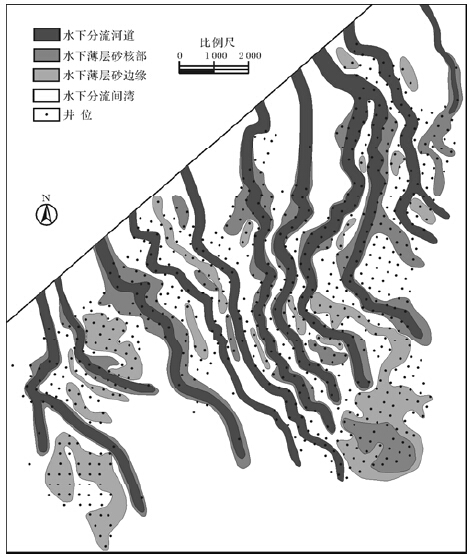
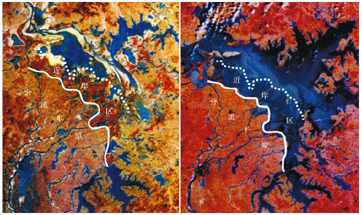
浅水湖盆河控三角洲形成于地形十分平缓的背景下,河口区不利于沉积物的大规模卸载,且湖水较浅,后期对沉积物的改造能力有限,因而三角洲前缘亚相砂体与正常三角洲相比相对不发育。由松辽盆地北部永乐地区葡萄花油层高密度井网条件下的沉积微相图与鄱阳湖赣江三角洲现代沉积卫星图片可清晰揭示出其骨架砂体为大量、密集(平均分布密度1.02/ km)、窄的(多为50~300 m)水下分流河道砂体(图 1,2),砂体较连续且水下延伸较远,直至消失变成薄的水下薄层砂(河口坝或席状砂),具明显河控性,呈现以水下分流河道砂体为中心的顺源、条带状砂体分布模式。
|
| 图 1 松辽盆地北部永乐地区葡萄花油层5小层沉积微相图 Fig. 1 Sedimentary microfacies of 5 sub-layers of Putaohua oil layer in Yongle area of Songliao Basin |
|
| 图 2 鄱阳湖枯水期(左)、洪水期(右)沉积环境变化遥感图(据邹才能等,2008) Fig. 2 Remote sensing map of sedimentary environment changes in the dry period (left) and the flood period (right) of Poyang Lake (after Zou,2008) |
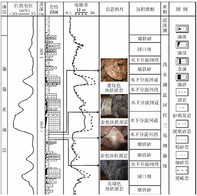
地形平缓和浅水背景造成浅水湖盆可容纳空间有限,加之沉积物供给充分,水下分流河道向湖延伸较远,直接叠置(或切蚀)于水下薄层砂(河口坝或席状砂)、水下分流间湾和前三角洲亚相泥岩之上,造成垂向沉积序列间断(图 3)。河口坝发育需要较强的湖水能量和较陡的河口区地形[12],浅水湖盆水动力较弱,地形平缓,沉积物较难大规模卸载,而是受河流影响向湖盆更深处迁移,保存难度大。因此,浅水湖盆河控三角洲河口坝不甚发育,多以水下薄层砂形式发育(图 1),形成了与经典三角洲对比鲜明的沉积特征。
|
| 图 3 松辽盆地北部永乐地区葡萄花油层单井沉积微相分析图(Zh29井) Fig. 3 Sedimentary microfacies of the drilling well of Putaohua oil layer in Yongle area of Songliao Basin |
浅水湖盆河控三角洲虽然平面上可以划分出三角洲平原、三角洲前缘和前三角洲亚相,但各亚相分异不完善,边界不清晰,呈现明显过渡演化关系。首先,在三角洲下分流平原区发育较大范围的近岸过渡带。由于地势平缓,且水体较浅、湖平面升降频繁[12],即使较微弱的湖平面升降也会波及较大区域,致使水下分流间湾长期处于弱氧化、弱还原沉积环境中而形成杂色(或暗紫色)泥岩或紫红色泥岩与灰绿色泥岩互层特征(图 3)。如鄱阳湖赣江三角洲洪水期下三角洲平原主体位于湖平面之下(图 2),水下分流河道进一步分汊,形成末端分流河道系统及水下分流间湾;枯水期则下三角洲平原主体位于水上,在洪水期形成的末端分流河道与末端决口扇体系展露无遗,洪水期水下分流间湾与主湖区隔离形成残留湖[12]。其次,在三角洲外前缘区发育明显浅湖沉积区。由于河流作用明显,水下分流河道在水下延伸很远,在枯水期甚至延伸至湖盆中心[12](图 2),仅在湖盆陡岸一侧形成面积局限的前三角洲沉积,且多以浅湖沉积为主,而经典三角洲的前三角洲亚相多以深湖、半深湖沉积为主,二者存在明显差异。
1.4 前积作用不明显,以垂向加积为主由于浅水湖盆河控三角洲形成于地形平缓、无明显的坡折带发育的构造背景下,因此较难形成Gilbert型三角洲的三褶结构,前积作用不明显[17],在纵向剖面上形成多旋回加积层序,地震剖面上多表现为叠瓦状、(亚)平行特征(图 4),极少见S形前积反射结构。

|
| 图 4 松辽盆地北部永乐地区葡萄花油层地震反射特征图 Fig. 4 The seismic reflection characteristics of Putaohua oil layer in Yongle area of Songliao Basin |
由松辽盆地北部永乐地区葡萄花油层高密度井网条件下的沉积微相研究与鄱阳湖赣江三角洲现代沉积调查不难看出,浅水湖盆河控三角洲前缘砂体成因类型较单一,主要发育水下分流河道砂体和水下薄层砂体,水下薄层砂体进一步可分为特征不典型的河口坝和分布范围有限的席状砂,由于二者沉积特征、成因机制、分布模式等相似,本次研究将其统一归为水下薄层砂体。 2.1.1 水下分流河道砂体
(1) 水下分流河道的河型
水下分流河道的河型决定其砂体的分布模式[18, 19, 20]。通过对鄱阳湖赣江三角洲最大枯水期22条水下分流河道的河型分析揭示出水下分流河道延伸长度多为1~5 km,宽度大多小于50 m,河型以低弯度或顺直型为主(图 5)。松辽盆地北部永乐地区葡萄花油层高密度井网条件下单砂体解剖也揭示了类似特征(图 1)。马世忠等[18]对现代41条水下分流河道的河型统计表明,顺直型水下分流河道是最常见的河型,其他类型较少见。
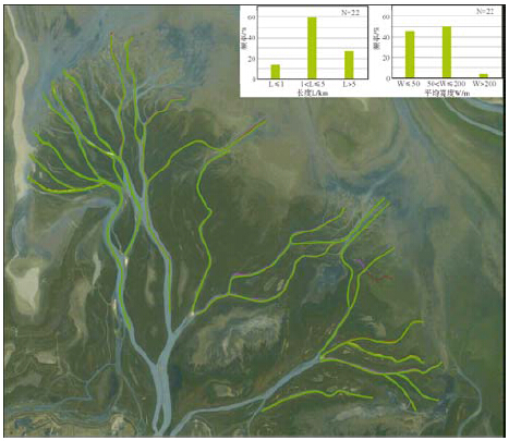
|
| 图 5 鄱阳湖赣江三角洲最大枯水期水下分流河道河型分析图 Fig. 5 The river type of underwater distributary channel in the dry period of Ganjiang delta of Poyang Lake |
(2) 水下分流河道砂体分布模式
由于河流从陆上注入蓄水盆地并向前延伸,经历不同的沉积环境,其地貌、水动力等特征差异较大,随着分流河道入海/湖及离岸水深增加,由于河流能量减弱及河流限定性逐渐变差,水下分流河道呈增宽趋势,下切深度逐渐减少至消失,水下分流河道特征逐渐不明显,最终变为末端或河控的水下薄层砂。为此,根据洪、枯水期的水位线位置及蓄水盆地水深、水动力、河流能量等条件,将水下分流河道细分为4段(图 6)。
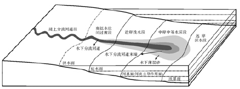
|
| 图 6 水下分流河道沉积模式图(据马世忠等略改,2012) Fig. 6 The sedimentary model of underwater distributary channel(Modified after Ma,2012) |
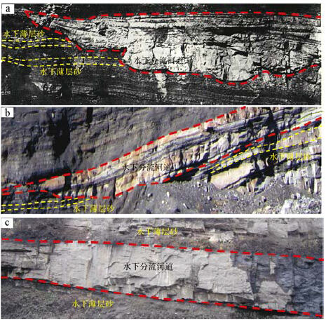
①高低水位间过渡段,即陆上分流河道与水下分流河道的过渡带,其洪水期处于水下、枯水期处于水上,该段水下分流河道继承陆上分流河道的特征,以向下切蚀能力强、限定性强为特征,两侧发育小规模不连续、顺源、带状薄层砂沉积(图 7a)。
②近岸浅水段,即长期处于近岸浅水环境下(枯水期水位线以下)仍具有明显向下切蚀能力的半限定性水下分流河道段(图 7b)。由于极浅的湖水对河道影响较小,但不可忽略,河道沉积特征仍很明显,河道两侧水下薄层砂的连续性变好和规模变大,“河控带状体”平面规模变大。
③中岸中等水深段,即近岸浅水段向盆一侧的中等水深带发育的逐渐失去向下切蚀能力和限定性的水下分流河道段(图 7c)。河流能量大大减弱,蓄水体能量增强,河道沉积特征不明显,河流定向水流呈长扇形扩散,形成席状化水下分流河道末端段,但仍具有明显河控性。
④远岸深水段,河流能量大大减弱,以蓄水体能量为主,河道沉积特征很不明显。
2.1.2 水下薄层砂体(河口坝或席状砂)通过对松辽盆地北部永乐地区葡萄花油层高密度井网条件下单砂体解剖和鄱阳湖赣江三角洲前缘现代沉积调查发现,水下薄层砂体垂向上多期、薄层叠置,平面上伴生于河道两侧、顺源(与湖岸线近于垂直)、窄带状分布,分布范围局限,密井网(250 m井距)控制下,在垂直于走向方向较少被三口井同时钻遇,宽度多在500 m以内(图 1)。根据水下薄层砂所处三角洲前缘亚相的区位(或水下分流河道段)不同,可分为4类分布模式(表 1)。A、B模式一般发育于三角洲内前缘水下分流河道带(过渡带、浅水带和中等水深带);C、D模式一般发育于三角洲外前缘(远岸深水带),该区位波浪作用强于河流作用;D模式发育区位的波浪作用要强于C模式,且碎屑物质供应充足。前三类模式在平面顺物源方向可以共生,C与D在平面顺物源方向上一般不共生。
| 序号 | 长度L/km | 平均宽度W/m | 河流类型 |
| 1 | 4.04 | 41.75 | 低弯顺直 |
| 2 | 3.04 | 19.55 | 低弯顺直 |
| 3 | 4.46 | 48.00 | 顺直低弯 |
| 4 | 1.73 | 15.50 | 顺直低弯 |
| 5 | 1.76 | 37.50 | 顺直 |
| 6 | 0.39 | 7.50 | 顺直 |
| 7 | 4.72 | 71.00 | 低弯顺直 |
| 8 | 3.00 | 56.25 | 低弯顺直 |
| 9 | 1.14 | 16.25 | 低弯 |
| 10 | 0.35 | 6.50 | 低弯顺直 |
| 11 | 0.60 | 7.00 | 低弯顺直 |
| 12 | 6.94 | 78.25 | 低弯顺直 |
| 13 | 5.58 | 39.50 | 低弯顺直 |
| 14 | 6.86 | 90.67 | 低弯 |
| 15 | 8.46 | 140.50 | 低弯顺直 |
| 16 | 5.08 | 121.00 | 低弯顺直 |
| 17 | 3.84 | 103.50 | 低弯顺直 |
| 18 | 5.72 | 232.50 | 顺直 |
| 19 | 3.53 | 142.50 | 顺直 |
| 20 | 4.46 | 120.50 | 低弯顺直 |
| 21 | 4.47 | 110.00 | 低弯顺直 |
| 22 | 2.86 | 97.50 | 低弯顺直 |
利用鄂尔多斯盆地的野外露头、鄱阳湖赣江三角洲现代沉积和松辽盆地北部永乐地区葡萄花油层地下岩芯、测井、地震等资料精细解剖及分析表明,浅水湖盆河控三角洲前缘亚相发育大量、密集(平均分布密度1.02/ km)、窄的(多为50~300 m)水下分流河道砂体,砂体连续且水下延伸较远,直至消失变成薄的薄层砂(河口坝或席状砂),河口坝砂体不发育,更多表现为薄层砂特征。每支水下分流河道构成了由中心向两侧及前方:水下分流河道→薄层砂核部→薄层砂边缘→水下分流间湾的平面微(能量)相序列,形成了三角洲前缘独具特征的“河控带状体”,该类“河控带状体”是浅水湖盆河控三角洲前缘砂体的基本构成单元。水下分流河道控制的平面多支、垂向多层的“河控带状体”空间叠置关系控制了三角洲前缘砂体分布特征与分布模式。
| 模式类型 | 形态特征 | 形成机理 | 与河道依存关系 |
| 河控 | 单河道顺源条带模式(A) | 顺河道、连续、条带形砂坝,向两侧变薄,且有不连续的坨状砂体出现。 | 河流能量强,沉积物供应充分,在河流作用控制下形成窄带状的、连续的、平行于水下分流河道的条带形砂坝。 | 与河道伴生 |
| 多河道顺源复合模式(B) | 多个顺河道、连续、指状沙坝向物源方向复合分布,向两侧变薄,且有不连续的坨状砂体出现。 | 河流能量强,沉积物供应充分,当河道分叉时形成多个窄的、条带状的、连续的分流砂坝,其向物源方向互相合并形成燕尾式砂坝或三角形砂坝。 | 与河道伴生 | |
| 浪控 | 浪控垂源模式(C) | 新月状、横条状垂直于物源分布、平面连续性较好。 | 波浪改造能量大于河流能量,河流带来的碎屑物质受波浪作用进一步改造,重新形成垂直于物源分布的新月状或横条状砂坝→拦门砂坝。 | 不与河道伴生 |
| 浪控放射状模式(D) | 顺物源放射坨状→席状分布,局部连续性好,平面总体呈坨状。 | 波浪改造能量大于河流能量,河道能量极为弱化,受较强波浪改造作用而形成的分布面积较大顺源放射坨状至席状砂坝。 | 不与河道伴生 |
高低水位间过渡带对应水下分流河道高低水位间过渡段,其在高水位期处于水下,低水位期处于水上,以近岸的过渡沉积为主。古湖岸越缓、古湖面变化越大,该带越宽。该带水下分流河道表现较为明显的限定性特征,以顺直河型为主,河流作用较强,沉积物质供应充足,形成以水下分流河道砂体为中心的连续、窄带状河控带状体,发育小规模水下薄层砂沉积,顺河道两侧不连续分布,为高水位期水下分流河道溢岸沉积(图 8),垂向上薄层砂呈现多期分布特征,可代表湖平面波动次数。水下分流河道间湾以大面积细粒泥质沉积为主,由于长期处于弱氧化、弱还原沉积环境,水下分流间湾以杂色(或暗紫色)泥岩或紫红色泥岩与灰绿色泥岩互层为主要特征(图 3)。
3.2 近岸浅水带“河控带状体”模式近岸浅水带对应水下分流河道近岸浅水段,仍以水下分流河道沉积为主,其具有限定性、半限定性河道及明显水下切蚀能力、河道沉积特征明显等特点,并控制了该区带微相类型、平面序列、分布、位置和规模等。每支水下分流河道构成了由中心向两侧及前方:“水下分流河道→水下薄层砂(多为泥质粉砂岩)→水下分流间湾(多为泥岩或粉砂质泥岩)”的平面微相序列(图 8),水下分流河道为该区带的骨架砂体,控制了“河控带状体”的组合特征和内在特征,构成该区带的沉积主体。由于受湖水长期作用,近岸浅水带的水下薄层砂相对高低水位间过渡带更发育、更连续,但仍然发育于分流河道两侧的有限范围内,水下分流河道砂体与薄层砂之间存在明显过渡关系(图 7b),进一步说明较浅的湖水对河道影响较小,但不可忽略。水下分流间湾多以灰色、灰绿色泥质沉积为主。
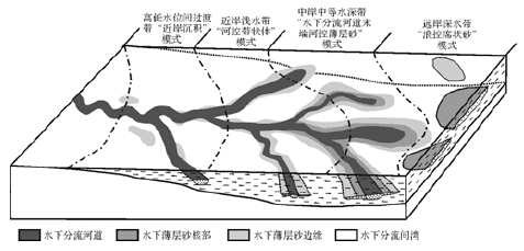
|
| 图 8 浅水湖盆河控三角洲前缘砂体分布特征与沉积模式图 Fig. 8 Sandbody distribution and depositional model of shallow lacustrine fluvial-dominated delta front |
由于水深进一步增大,湖水顶托作用进一步增强,湖水对于水下分流河道沉积的改造进一步增强。中岸中等水深带(对应水下分流河道中岸中等水深段)的河流定向水流逐渐呈长扇形扩散,水下分流河道逐渐失去水下切蚀能力和限定性。取而代之的是基本无水下切蚀能力和限定性的水下分流河道末端及其控制的薄层砂(河口坝或席状砂)沉积,薄层砂呈较大面积分布,但呈明显的河控性,以水下分流河道末端为中心,向两侧、前方依次为:“水下分流河道末端→水下薄层砂核部(以粉砂岩为主)→水下薄层砂边缘(以泥质粉砂岩、粉砂质泥岩为主)→水下分流间湾(以泥岩为主)”的递变特征(图 8)。这种沉积特征说明此时是湖水相对较深、离岸较远的时期,水下河流能量已经较弱,河流携带的砂质载荷大幅减少、泥质载荷增多;加之湖底平缓、绝对水深较浅,波浪能量很弱,致使该区仍以河流余能为主,形成水下分流河道末端及其控制的河控薄层砂,二者边界呈现明显渐变过渡关系,甚至无明显边界。水下分流间湾以灰绿色、深灰色泥质沉积为主,甚至出现块状黑色泥岩。
3.4 远岸深水带“浪控席状砂”模式远岸深水带对应水下分流河道远岸深水段,主要为浅水湖盆河控三角洲前缘亚相的外前缘区,远离物源,沉积物供给不足,沉积物粒度明显变细,多以泥质粉砂岩和粉砂质泥岩为主。河流作用很不明显,甚至无河道特征。蓄水体作用显著增强,开始出现较大规模的席状砂沉积(图 8),且呈明显的“浪控性”,主要特征为:①单一席状砂呈顺岸垂源分布;②多席垂源平行排列;③具由中部向四周:“席状砂核部(钙质粉砂岩)→席状砂边缘(含泥粉砂岩、泥质粉砂岩)→席状砂间(粉砂质泥岩、泥岩)”的明显条带环状平面分布模式。浅水湖盆河控三角洲前缘河流作用为主导因素,湖浪作用不明显,浪控席状砂不发育为该类三角洲的典型特征。
4 结论(1) 浅水湖盆河控三角洲前缘亚相发育大量、密集(平均分布密度1.02/km)、窄的(多为50~300 m)水下分流河道砂体,砂体连续且水下延伸较远,直至消失变成薄的薄层砂,河口坝砂体不发育,更多表现为薄层砂特征。
(2) 以每支水下分流河道为中心形成三角洲前缘“河控带状体”。每支“河控带状体”由中心向两侧及前方形成了水下分流河道→水下薄层砂(河口坝或席状砂)核部→水下薄层砂边缘→水下分流间湾的平面微(能量)相序列。
(3) 浅水湖盆河控三角洲前缘不同的相位空间位置具有不同的沉积模式,由岸向湖依次发育高低水位间过渡带“近岸沉积”模式、近岸浅水带“河控带状体”模式、中岸中等水深带“水下分流河道末端河控薄层砂”模式和远岸深水带“浪控席状砂”模式。
| [1] | 朱筱敏, 刘媛, 方庆, 等. 大型坳陷湖盆浅水三角洲形成条件和沉积模式:以松辽盆地三肇凹陷扶余油层为例[J]. 地学前缘, 2012, 19(1):89-99. Zhu Xiaomin, Liu Yuan, Fang Qing, et al. Formation and sedimentary model of shallow delta in large-scale lake:Example from Cretaceous Quantou Formation in Sanzhao sag, Songliao Basin[J]. Earth Science Frontiers, 2012, 19(1):89-99]. |
| [2] | 王立武. 坳陷湖盆浅水三角洲的沉积特征——以松辽盆地南部姚一段为例[J]. 沉积学报, 2013, 30(6):1053-1060. [Wang Liwu. Forming conditions and depositional characteristics of shallow-water deltas in depression basins:A case study of K2y1 in the south of Songliao Basin[J]. Acta Sedimentologica Sinica, 2013, 30(6):1053-1060]. |
| [3] | 楼章华, 兰翔, 卢庆梅, 等. 地形、气候与湖面波动对浅水三角洲沉积环境的控制作用——以松辽盆地北部东区葡萄花油层为例[J]. 地质学报, 1999, 73(1):83-92.[Lou Zhanghua, Lan Xiang, Lu Qingmei, et al. Controls of the topography, climate and lake level fluctuation on the depositional environment of a shallow-water delta——A case study of the Cretaceous Putaohua reservoir in the northern part of Songliao Basin [J]. Acta Geologica Sinica, 1999, 73(1):83-92]. |
| [4] | 王建功, 王天琦, 卫平生, 等. 大型坳陷湖盆浅水三角洲沉积模式——以松辽盆地北部葡萄花油层为例[J]. 岩性油气藏, 2007, 19(2):28-34. [Wang Jiangong, Wang Tianqi, Wei Pingsheng, et al. Sedimentary mode of shallow lacustrine delta of large continental basin——An example from Putaohua Formation in northern Songliao Basin [J]. Lithologic Reservoirs, 2007, 19(2):28-34]. |
| [5] | Fisk H N. Sedimentary framework of the modern Mississippi delta [louisiana][J]. Journal of Sedimentary Research, 1954, 24(2):76-99. |
| [6] | Lemons D R, Chan M A. Facies architecture and sequence stratigraphy of fine-grained lacustrine deltas along the eastern margin of Late Pleistocene Lake Bonneville, northern Utah and southern Idaho[J]. AAPG Bulletin, 1999, 83(4):635-665. |
| [7] | Hoy R G, Ridgway K D. Sedimentology and sequence stratigraphy of fan-delta and river-delta deposystems, Pennsylvanian Minturn formation, Colorado[J]. AAPG Bulletin, 2003, 87(7):1169-1191. |
| [8] | 楼章华, 袁笛, 金爱民. 松辽盆地北部浅水三角洲前缘砂体类型、特征与沉积动力学过程分析[J]. 浙江大学学报:理学版, 2004, 31(2):211-215. [Lou Zhanghua, Yuan Di, Jin Aimin. Types, characteristics of sandbodies in shallow-water deltafront and sedimentary models in northern Songliao Basin, China [J]. Journal of Zhejiang University:Science Edition, 2004, 31(2):211-215]. |
| [9] | 张昌民, 尹太举, 朱永进, 等. 浅水三角洲沉积模式[J]. 沉积学报, 2010, 28(5):933-944. [Zhang Changmin, Yin Taiju, Zhu Yongjin, et al. Shallow water deltas and models [J]. Acta Sedimentologica Sinica, 2010, 28(5):933-944]. |
| [10] | 韩永林, 王成玉, 王海红, 等. 姬塬地区长8油层组浅水三角洲沉积特征[J]. 沉积学报, 2009, 27(6):1057-1064. [Han Yonglin, Wang Chengyu, Wang Haihong, et al. Sedimentary characteristics of shallow-water deltas in Chang-8 Subsection of Yanchang Formation, Jiyuan area[J]. Acta Sedimentologica Sinica, 2009, 27(6):1057-1064]. |
| [11] | 朱伟林, 李建平, 周心怀, 等. 渤海新近系浅水三角洲沉积体系与大型油气田勘探[J]. 沉积学报, 2008, 26(4):575-582. [Zhu Weilin, Li Jianping, Zhou Xinhuai, et al. Neogene shallow water deltaic system and large hydrocarbon accumulations in Bohai Bay, China [J]. Acta Sedimentologica Sinica, 2008, 26(4):575-582]. |
| [12] | 邹才能, 赵文智, 张兴阳, 等. 大型敞流坳陷湖盆浅水三角洲与湖盆中心砂体的形成与分布[J]. 地质学报, 2008, 82(6):813-825. [Zou Caineng, Zhao Wenzhi, Zhang Xingyang, et al. Formation and distribution of shallow-water deltas and central-basin sandbodies in large open depression lake basins [J]. Acta Geologica Sinica, 2008, 82(6):813-825]. |
| [13] | 金振奎, 李燕, 高白水, 等. 现代缓坡三角洲沉积模式——以鄱阳湖赣江三角洲为例[J]. 沉积学报, 2014, 32(4):710-723.[Jin Zhenkui, Li Yan, Gao Baishui, et al. Depositional model of modern gentle-slope delta:A case study from Ganjiang Delta in Poyang Lake [J]. Acta Sedimentologica Sinica, 2014, 32(4):710-723]. |
| [14] | 吕晓光, 李长山, 蔡希源, 等. 松辽大型浅水湖盆三角洲沉积特征及前缘相储层结构模型[J]. 沉积学报, 1999, 17(4):572-577.[Lü Xiaoguang, Li Changshan, Cai Xiyuan, et al. Depositional characteristics and front facies reservoir framework model in Songliao shallow lacustrine delta [J]. Acta Sedimentologica Sinica, 1999, 17(4):572-577]. |
| [15] | 李元昊, 刘池洋, 独育国, 等. 鄂尔多斯盆地西北部上三叠统延长组长8油层组浅水三角洲沉积特征及湖岸线控砂[J]. 古地理学报, 2009, 11(3):265-274.[Li Yuanhao, Liu Chiyang, Du Yuguo, et al. Sedimentary characteristics of shallow water delta and lake shoreline control on sandbodies of Chang 8 oil-bearing interval of the Upper Triassic Yanchang Formation in northwestern Ordos Basin[J]. Journal of Palaeogeography, 2009, 11(3):265-274]. |
| [16] | 尹太举, 李宣玥, 张昌民, 等. 现代浅水湖盆三角洲沉积砂体形态特征——以洞庭湖和鄱阳湖为例[J]. 石油天然气学报, 2012, 34(10):1-8. [Yin Taiju, Li Xuanyue, Zhang Changmin, et al. Sandbody shape of modern shallow lake basin delta sediments—— by taking Dongting Lake and Poyang Lake for example[J]. Journal of Oil and Gas Technology, 2012, 34(10):1-8]. |
| [17] | 朱筱敏, 潘荣, 赵东娜, 等. 湖盆浅水三角洲形成发育与实例分析[J]. 中国石油大学学报:自然科学版, 2013, 37(5):7-14. [Zhu Xiaomin, Pan Rong, Zhao Dongna, et al. Formation and development of shallow-water deltas in lacustrine basin and typical case analyses[J]. Journal of China University of Petroleum, 2013, 37(5):7-14]. |
| [18] | 马世忠, 张永清. 应用遥感信息图像研究现代水下分流河道河流类型[J]. 地学前缘, 2012, 19(2):24-31. [Ma Shizhong, Zhang Yongqing. Research on the channel pattern of present subaqueous distributary channel by remote sensing image [J]. Earth Science Frontiers, 2012, 19(2):24-31]. |
| [19] | Olariu C, Bhattacharya J P. Terminal distributary channels and delta front architecture of river-dominated delta systems [J]. Journal of Sedimentary Research, 2006, 76(2):212-233. |
| [20] | 张新涛, 周心怀, 李建平, 等. 敞流沉积环境中“浅水三角洲前缘砂体体系”研究[J]. 沉积学报, 2014, 32(2):260-269.[Zhang Xintao, Zhou Xinhuai, Li Jianping, et al. Unconfined flow deposits in front sandbodies of shallow water deltaic distributary systems [J]. Acta Sedimentologica Sinica, 2014, 32(2):260-269]. |
| [21] | 李思田. 含能源盆地沉积体系[M]. 武汉:中国地质大学出版社, 1996:62-68. Li Sitian. Depositional Systems in Energy-Resources-Bearing Basins [M]. Wuhan:China University of Geosciences Press, 1996:62-68.] |
 2015, Vol. 33


