2) Southern Marine Science and Engineering Guangdong Laboratory (Guangzhou), Guangzhou 511458, China;
3) China-Pakistan Joint Research Center on Earth Science, CAS-HEC, Islamabad 45320, Pakistan;
4) University of Chinese Academy of Sciences, Beijing 100049, China;
5) Department of Ocean Science and Engineering, Southern University of Science and Technology, Shenzhen 518055, China;
6) Chongqing Institute of Geological Survey, Chongqing 401122, China;
7) Key Laboratory of Exploration Technologies for Oil and Gas Resources, Ministry of Education, Yangtze University, Wuhan 430100, China
The Earth's interior is in a constant cycle of material, energy, and force, which leads to the motion and deformation of crustal or lithospheric blocks (Morgan, 1968). The plate motions control a lot of geological processes on Earth's surface, such as seafloor morphology, oceanic crustal structure, submarine volcanic activity, and underwater sedimentation (Qie, 1996). Studies of the crustal structure on kinematics, geometry, and dynamics can provide insights into the Earth's surface and interior geology, and its impact on the environment and resources.
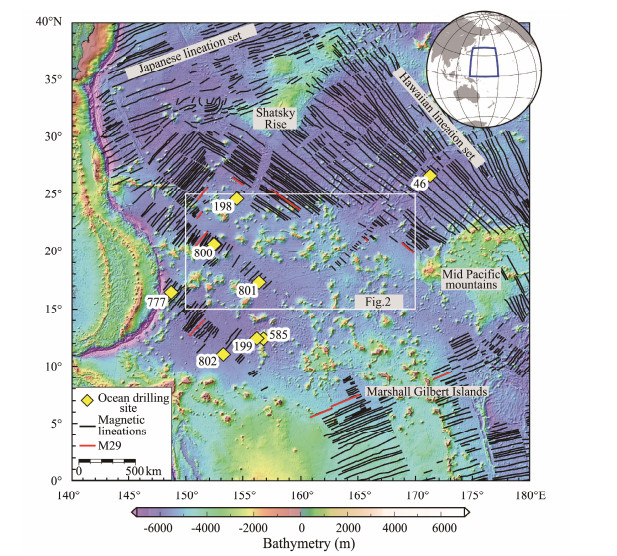
The Jurassic oceanic crust has the oldest age on the present seafloor. It is only distributed at limited places in the oceans (e.g., in the west Pacific Ocean, and several continent-ocean transition zones of the Atlantic and the Indian Ocean). Most segments of the Jurassic oceanic crust occur in the West Pacific Ocean, among which those in the Pigafetta Basin appear to be the oldest (Koppers et al., 2003; Fig.1). Nevertheless, it is difficult to carry out the survey there because of the far distance from land and great water depth (> 5 km; Song and Li, 2016). The Jurassic oceanic crust in the west Pacific Ocean shows low-amplitude magnetic anomalies from the Mesozoic magnetic stripes M22 to M42 (Tominaga et al., 2008, 2015; Ogg et al., 2010), which is similar to the Cretaceous magnetic quiet zone and thus called the Jurassic Quiet Zone (JQZ, Larson and Chase, 1972; Larson and Hilde, 1975; Cande et al., 1978). The JQZ is mainly located in the Pigafetta Basin, east of the eastern Mariana Trench and west of the middle Pacific Rise (Fig.2), where it is hard to decode the tectonic history by such weak magnetic lineations. Moreover, the ancient Jurassic crust is covered by thick sediments (Lancelot and Larson, 1975; Behl and Smith, 1992; Karl et al., 1992; Larson et al., 1992; Moore, 2008), and only a few crustal features are exposed to the seafloor. Hence, the crustal structure of the JQZ remains poorly understood.
|
Fig. 1 Map of the west Pacific Ocean with the study area outlined in white box. Major features are labeled. Ocean drilling sites are marked by yellow diamonds (ODP and DSDP sites). Magnetic isochrons drawn in black and red lines are from Stadler and Tominaga (2015), Tominaga et al. (2015, 2021). Seafloor topography data are from GEBCO (https://www.gebco.net). |
|
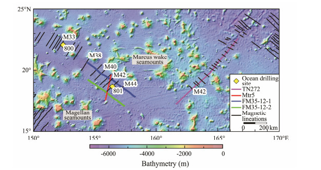
Fig. 2 Bathymetry map of the study area within the JQZ (Jurassic Quiet Zone). The locations of 2D MCS (multichannel seismic) reflection profiles, magnetic anomaly stripes, and ODP Site 800 and 801 are shown. Other symbols are the same as Fig. 1. |
This study aims to study the structure and deformation of the Jurassic oceanic crust in the JQZ of the West Pacific Ocean. We used high-resolution multichannel seismic (MCS) reflection profiles combined with available bathymetry, magnetic, and gravity data to interpret the structures of the oceanic crust and sedimentary strata, and compared the structural differences of oceanic crusts between the JQZ and the East Pacific Rise (EPR). We 1) determined key stratigraphic boundaries on the high-resolution MCS profiles, i.e., Moho, top of basement, seafloor; 2) recognized the key structures within the oceanic crust, such as faults, folds, and the vertical seismic disturbance zone (VSDZ); 3) discerned the primary seafloor morphology, e.g., scarps, seamounts, hills; 4) and finally discussed their forming mechanisms and compared with the youngest oceanic crust on the earth.
2 Geological SettingIn general, since the Jurassic oceanic crust within the JQZ was formed by seafloor spreading, this primitive oceanic crust recorded the formation and evolution of mid-ocean ridge, and documented the associated deformation effects. Subsequently, massive magmatic intrusions (Cretaceous) appear to reform the primitive Jurassic crust and its overlying sediments (Abrams, 1993; Feng et al., 2015; Stadler and Tominaga, 2015; Feng, 2016). The JQZ oceanic crust was drilled by the Ocean Drilling Program (ODP) in 1989 and 1990, at Sites 800 and 801 in the Pigafetta Basin and Site 802 in the East Mariana Basin (Fig.1, Shipboard Scientific Party, 1990a, 1990b). The Cretaceous igneous rocks were cored at Sites 800 and 802, whereas the basaltic Jurassic basement was recovered at Site 801. Therefore, the oceanic crust in the JQZ underwent two stages of magmatism: the seafloor spreading and mid-ocean ridge crustal accretion in Jurassic 170 Myr, and the late-stage magma intrusion in Cretaceous around 75 – 125 Myr. The latter is welldeveloped, with massive dimensions throughout the Pacific Ocean, for example, the mid-Pacific Seamounts, Ontong Java Plateau, Shatsky Rise, Marshall Islands, and thousands of guyots, seamount cones, and volcanic debris flow (Xu, 2002; Xu and Zhou, 2003; Pang et al., 2011; Lu et al., 2016; Xue and King, 2016; Chen and Liu, 2018; Luo et al., 2019). The magma intruded into and overlying the Jurassic igneous basement as sills, dikes, and seamounts. Dikes and seamounts were formed by central, pipe-like migration processes of magma, which were able to traverse the Moho surface, oceanic crust, and sediments, and outpour onto the seafloor (Feng et al., 2015; Stadler and Tominaga, 2015; Zhang et al., 2022). In addition, a large number of sills intruded into the lithosphere at various depths, resulting in the increased thickness of the whole oceanic crust (Feng et al., 2015; Stadler and Tominaga, 2015).
Pelagic sediments atop the oceanic crust of the JQZ are 200 – 450 m thick, and reach 400 – 500 m in the Pigfetta Basin (Feng et al., 2015; Stadler and Tominaga, 2015). The water depths of the study area are around 5000 – 6000 m (Fig.2), lower than the carbonate compensation depth (Hesse, 1988). The sediments are mainly composed of silicates and clays, occasionally with volcaniclastics. In the Jurassic and Cretaceous, this area was located near the equator, where the marine biological productivity was high. Siliceous sediments were deposited at an average rate of 3 m Myr−1 (Lancelot and Larson, 1975; Behl and Smith, 1992; Karl et al., 1992; Larson et al., 1992; Moore, 2008). According to the results of ODP (Shipboard Scientific Party, 1990a, 1990b), siliceous oozes at the upper sedimentary layers mainly consists of Opal-A, an amorphous siliceous mineral, while down to the lower sedimentary layers they transform into compact, solid porcelains and cherts. In the seismic profiles, siliceous sedimentary layers are associated with smooth, continuous reflection images (Feng et al., 2015; Stadler and Tominaga, 2015; Zhang et al., 2022). The layers containing porcelains and cherts show relatively strong reflection amplitude, because porcelain and chert have lower porosity, higher density, and faster seismic velocity than clays, leading to greater P-wave wave impedance (Abrams et al., 1992; Ewing et al., 2012). The interface between the clay layer and siliceous layer represents the sedimentary environment transition from the equator to the North Pacific subtropical region, which was confirmed by multiple drilling sites, i.e., Sites 800 and 801 of ODP, and Sites 46, 198, 199, 307 of the Deep-Sea Drilling Program (DSDP) (Pimm et al., 1971; Heezen et al., 1973; Lancelot and Larson, 1975; Shipboard Scientific Party, 1990a, 1990b; Karl et al., 1992).
3 Data and MethodsTo document the crustal structure of the JQZ in the west Pacific Ocean, we used MCS reflection data from three active source seismic surveys (Fig.2): Mtr5 (Kaneda et al., 2010), FM35-12 (Shipley et al., 2012), and TN272 (Tominaga et al., 2012). The 250 km-long seismic profile of Mtr5 is located between the Marcus Wake Seamounts and Magellan Seamounts, trending nearly N-S. Two NW-SE profiles totally 930 km from the survey FM35-12 intersect with the Mtr5 profile near Site 801. The latest seismic data were collected by the cruise TN272. A combined seismic line of TN272 trending NE-SW is approximately 800 km long and to the east of the Marcus Wake Seamounts. The data acquisition and processing parameters of these three seismic surveys are shown in Table 1.
|
|
Table 1 Seismic data acquiring and processing parameters from the survey Mtr5 (Kaneda et al., 2010), FM35-12 (Shipley et al., 2012), and TN272 (Tominaga et al., 2012). |
The MCS profiles were interpreted using standard seismic stratigraphy techniques (Mitchum et al., 1977). In the MCS profiles, seismic sequences and horizons were recognized, traced, correlated, and interpreted in geological terms. Our particular focus was the Moho, igneous basement and its overlying sedimentary layers, and these structures were interpreted based on the results from previous studies (Heezen et al., 1973; Lancelot and Larson, 1975; Abrams et al., 1992; Ewing et al., 2012; Feng et al., 2015; Stadler and Tominaga, 2015; Zhang et al., 2022). Relevant specific methods consist of stratigraphic characterization, fault analysis, and tectonic interpretation.
The M series of magnetic anomaly were obtained from Stadler and Tominaga (2015), Tominaga et al. (2015, 2021). This dataset was built on previous observations of the magnetic anomaly in the west Pacific Ocean (Handschmacher et al., 1988; Nakanishi et al., 1992; Sager et al., 1998; Tominaga et al., 2008).
To reflect the plan-view relationships among seafloor topography, basement morphology, magnetic anomaly, as well as gravity anomaly, maps of bathymetry, residual bathymetry, magnetic anomaly, and free air gravity anomaly were constructed. The bathymetry data were from GEBCO (www.gebco.net). The residual bathymetry data demonstrating the basement morphology were calculated from some global data including seafloor bathymetry, sediment thickness, and crust age (www.ngdc.noaa.gov; Müller et al., 2008; Sandwell et al., 2014). The magnetic anomaly map was plotted based on the satellite magnetic anomaly data (EMAG2v3, Meyer et al., 2017). The summits of many late-stage intrusive seamounts exhibited anomalously high-amplitude magnetic anomalies, making their validity doubtful. Thus, we set a threshold of −150 to 150 nT for our data, to better present magnetic anomaly characteristics of the normal oceanic crust. In addition, the data of free-air gravity anomaly were taken from Sandwell et al. (2014).
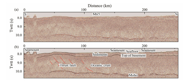
4 Results 4.1 Crustal StructureThe seismic profile Mtr5 trends NNE-SSW and crosses the magnetic stripes M41-M43 in the Pigfetta Basin (Fig.2; Kaneda et al., 2010). It is the deepest profile available in this area, penetrating to the sub-Moho (Fig.3), and thus allows good constraints on the crustal structure in the JQZ. As shown in Fig.3, from shallow to deep, the profile penetrates the seafloor, top of basement, oceanic crust, Moho, and sub-Moho. The most distinct feature on this profile is the Moho, which lies at 10 – 11 s Twtt (two way travel time) in depth. Kaneda et al. (2010) and Stadler and Tominaga (2015) modeled on this profile and found that the Moho is at 7.5 – 8 km beneath the seafloor. Overall, it slightly dips to the north, with several segments. The gaps between these segments are well corresponding to the seamounts. For instance, at the southmost part of the profile (< 50 km in horizontal distance; Fig.3), the Moho is poorly imaged and almost invisible from the seismic reflection. Two seamounts occur on the seafloor of this area. At 50 – 100 km in horizontal distance, the Moho is curved with its overall geometry resembling the top of basement that lies at shallow depth (8 – 8.5 s Twtt).
|
Fig. 3 Uninterpreted seismic profile MTr5 (a), and the oceanic crust and Moho interpreted in the Jurassic Quiet Zone (b). Black lines denote the top and bottom of the igneous crust. Red lines represent faults. The location of seismic profile is shown in Fig. 2. |
Above the Moho is oceanic crust, whose most distinct features are the large north-dipping thrust faults between 50 – 100 km from the south end of the profile. These thrust faults are interpreted based on three lines of evidences: 1) the parallel, oblique, strong seismic reflectors, 2) the slight upward offset of top basement along these strong seismic reflectors, 3) very mild seafloor expression (i.e., scarps) of these reflectors (Fig.3). These faults are crustal-scale structures and are rooted on the Moho. They extend upward to the top of basement and almost deform the entire crust. However, they are very localized, and only visible in the south part of this profile (Stadler and Tominaga, 2015).
The top of basement is mapped at the 8 – 8.5 s in depth. Similar to the Moho, it is also not visible beneath the seafloor where the seamount is presented. Both the Moho and top of basement seem to be penetrated and broken by the upward movement of magmatic materials and related hydrothermal vents. Layers above the top of basement represent the sedimentary deposits, which are generally thick away from seamount, thin above seamount and broadly curved on the top of basement (Fig.3).
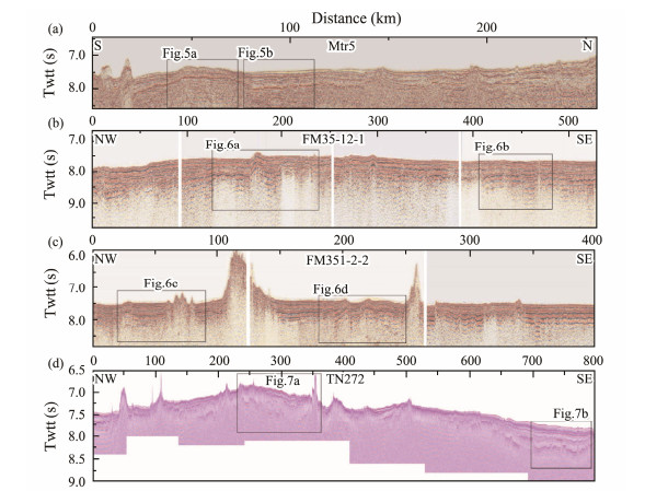
4.2 Sedimentary DeformationThe deformation of shallow sediments well documents the formation and evolution of geological structures. In the Pacific, 200 – 450 m thick sedimentary layers are predominantly made up of siliceous and clay sediments, with volcanoclastic and pelagic carbonate sediments in the deep (Lancelot and Larson, 1975; Shipboard Scientific Party, 1990a, 1990b; Karl et al., 1992; Greene et al., 2020). Fig.4 presents all the seismic profiles that have been examined in details for the sedimentary structure and deformation.
|
Fig. 4 Four uninterpreted seismic profiles MTr5, FM35-12-1, FM35-12-2, and TN272, showing the overall subseafloor structure of upper crust within the Jurassic Quiet Zone. The areas for detailed interpretation are outlined by black boxes. |
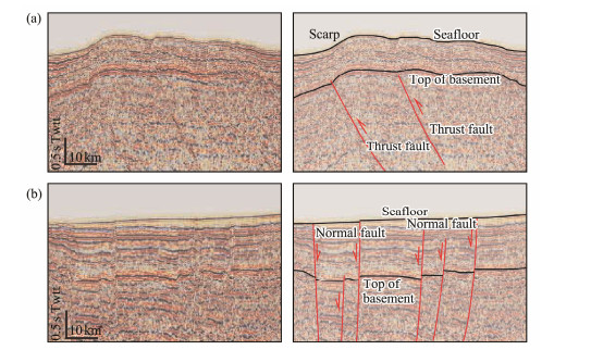
As shown in Fig.5a, the sediments seem to be deformed by folds with a wide inter-limb angle. Beneath the folds developed the large thrust faults. So, these folds are interpreted as fault-propagation folds (Erslev, 1991). In Fig.5b, the sediments are largely truncated and deformed by highangle normal faults (e.g., Williams, 1987; Greene et al., 2020; Zhang et al., 2022). These faults are deep crustal structures as they extend into the deep oceanic crust, and displace the top of basement with offsets. Such observations suggest that these faults are developed early and reactivated at the present. The hanging wall has developed relatively thicker sediments compared to the footwall, because the growth of normal faults provides more space on the hanging wall that allows more sediments to be deposited.
|
Fig. 5 Zoom-in images from the seismic profile Mtr5. The left panels show uninterpreted data, whereas the right panels add the interpretations, including the seafloor, the interface between the sediment layers and the basement, and fault structures. Black lines denote the seafloor (top) and the top of igneous basement (bottom). Red lines represent faults. The location of zoomed areas is shown in Fig. 4. |
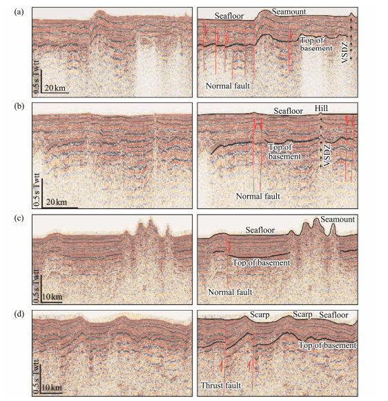
Fig.6 shows two parallel seismic profiles FM35-12-1 and FM35-12-2 with an interval of 100 km (Figs.2, 3). Similar to the observations in Fig.5, the sediments are mostly deformed by normal faults on these two profiles as faults clearly displace the sediments with observable offsets at the base of sediment layers (or the top of basement). Apart from this, the sediments are also deformed by the volcanorelated features, such as VSDZs (Stadler and Tominaga, 2015; Figs.6a, 6b). The folds are common in the sediments of this area. Some of them are related to seamounts (Fig. 6a), and others are resulted from the growth of thrust faults (Fig.6d) which are attributed to the lateral compression from seamounts due to the gravity sliding and sediment movement (Zhang et al., 2022). In the area of several small seamounts (Fig.6c), the sediments are poorly imaged, due to either the lack of sediments or the geochemical interaction between sediments and volcanic materials.
|
Fig. 6 Zoom-in images from the seismic profile FM35-12-1 and FM35-12-2. The left panels show uninterpreted data whereas the right panels add the interpretations, including the seafloor, seamounts and fault scarps, the interface between the sediment layers and the basement, fault structures in the basement, and VSDZ (vertical seismic disturbance zone). Black arrows denote VSDZ. Red lines represent faults. The location of zoomed areas is shown in Fig. 4. |
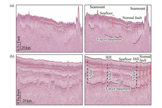
In Fig.7, the sediments are similarly deformed by both faults and seamount-related features. The major difference here is that there are a number of small folds between small normal faults and seamounts (Zhang et al., 2022). They are interpreted as the results of sediment moving away from seamounts, and in turn lead to the compressional deformation at the frontal region of sediment moving (Rowan et al., 2004; Yang et al., 2020).
|
Fig. 7 Same as Fig. 6 but for seismic profile TN272. Blue lines show the top of igneous basement. Black arrows denote VSDZ. Red lines represent faults. The location of zoomed areas is shown in Fig. 4. |
The seafloor morphology is of great importance to understanding the history of oceanic crust. Here we try to classify the key features on the seafloor so as to decipher how they are formed and distributed in response to the evolution of oceanic crust in the JQZ. As shown in Figs.4, 6, 7 and 8, the volcanic features dominated the seafloor morphology (e.g., Planke et al., 2005; Polteau et al., 2008; Stadler and Tominaga, 2015). The most significant seafloor morphology are seamounts with different sizes. The largest seamount on the seismic profile is shown in Fig.4c, with a height of 1.5 s Twtt and a width of 20 – 30 km. Other seamounts are shown on other seismic profiles in Figs.4, 6 and 7 with varied sizes and shapes. For instance, the seamounts at 30 km, 110 km and 350 km in Fig.4d has very sharp and steep flanks, while the seamounts at 10 – 20 km in Fig.4a, at 70 km in Fig.4b, at 120 km in Fig.4c, are rounded with curved tops and shallow dips of flanks. The size and shape of seamounts are related to many factors, such as the amount of magmatic materials and the seafloor process.
|
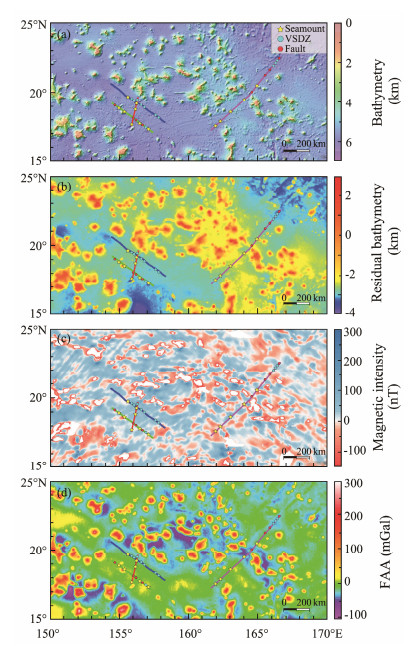
Fig. 8 The spatial distribution of identified faults, seamounts and VSDZs on the maps of seafloor topography (a); residual bathymetry (b); magnetic anomaly (c); and free-air gravity anomaly (d). The locations of seismic profiles are also shown in Fig. 2. |
The second most distinct feature on the seafloor is the fault scarp. As shown in Fig.5b, normal faults create small scarps on the seafloor, indicating that they are active at present (Zhang et al., 2022). Such features are also observed in Figs.6c, 6d. It is worth noting that, except for fault scarps, the scarps in Fig.6d are mostly fold scarps, and they are not directly formed by the displacement of faults. Instead, they are formed by the shortening of horizontal distance for the stack of sediments in relation to the growth of faults. In other words, they are the indirect results of fault growth. Similarly, fault scarps or seamounts are also observed on seafloor in Fig.7.
The third most clear seafloor feature is the thermal fluid migration zone in association with magmatic activities, formed by the VSDZ (Stadler and Tominaga, 2015). They are observed at several places in Figs.6a, 6b, 7b. The seafloor expression of VSDZ is generally small (1 km wide, < 0.1 s height) and symmetric hills. They are not prominent for the small sizes, so are interpreted as the least important morphological features on the seafloor.
5 Discussion 5.1 Mechanism of Crustal Deformation in the JQZThe JQZ occurs the world's existing oldest oceanic crust (Larson and Chase, 1972; Cande et al., 1978), whose structure carries essential information about the earth's evolution. Here, using four MCS profiles, we investigate the structure of the JQZ oceanic crust. The Moho of JQZ lies at 2 – 2.5 s (Twtt) beneath the seafloor (Fig.3), it is slightly segmented with small gaps and even missing at some places in seismic profiles. The poorly imaged Moho is found to be correlated with the seamounts (Fig.3; Stadler and Tominaga, 2015). We, therefore, interpret that the upward movement of magmatic materials from the mantle to the seamount has partially broken the previous ocean crust, and the seamount is a relatively young feature.
Another key feature observed in the JQZ is the crustal-scale thrust fault. It is indeed unusual to find a large number of compressional structures in an oceanic crust that is deformed mainly under the extensional environment. It is observed that these thrust faults are localized in the southmost area of profile Mtr5 (Fig.3; Kaneda et al., 2010; Stadler and Tominaga, 2015). Their growth seems to have deformed the top of basement, with a slight expression on the seafloor, i.e., scarp or rounded morphology (Zhang et al., 2022). These thrust faults do not lead to distinct seafloor displacements, suggesting that their recent activities are not strong. To reconcile the thrusting and extension in the JQZ, we propose that these faults are inverse tectonics developed from initial normal faults formed during the early extensional scenario and inverted during the later compressional period, similar to the observation made in the northern Kenyan Rift by Morley et al. (1992). The occurrence of compression tectonics in sediments is preliminarily explained by Zhang et al. (2022) as the frontal shortening of sediment layers that move laterally away from seamounts due to the gravity collapse. However, as these thrust faults are crustal structures, we suggest that further evidence is needed to support the crustal compression in the JQZ.
The third significant features in the JQZ are the widespread normal faults. They displaced the top of basement and the seafloor to form distinct fault scarps (Fig.5). Some of these normal faults are still active and have been propagated from the basement with decreasing displacement upward (see also Zhang et al., 2022), and therefore they are probably the reactivated basement structures.
Seamounts are also common features, widely distributed in the JQZ (Fig.8). However, based on the current datasets, there is no obvious pattern for the types and distribution of these seamounts. In-depth investigation in the future, possibly by deep 3D seismic imaging and tomography, may be able to resolve this problem.
5.2 Relationship of Faults with Geophysical Characteristics in the JQZTo present a broad view of the faulting structures over the JQZ, we analyze the geophysical characteristics based on the seafloor topography, residual bathymetry, magnetic anomaly, and free-air gravity anomaly (Fig.8). The residual bathymetry map shows the morphology of the Jurassic igneous crustal basement. Positions of faults are in agreement with the changes of basement topography (see also Zhang et al., 2022), implying that these faults were formed and controlled by the basement deformation. Magnetic anomalies reflect tectonic traces of mid-ocean ridge spreading during the formation of the Jurassic oceanic crust. Although magnetic signals are weak and the identified magnetic isochrons are few in the JQZ, the faults in our MSC profiles run parallel or sub-parallel to the limited known magnetic isochrons (Fig.2; Stadler and Tominaga, 2015; Tominaga et al., 2015, 2021), implying that these faults grew from the spreading of the Jurassic mid-ocean ridges and continued to be active till now. In addition, the free-air gravity anomaly is the combined effect of crust and mantle gravity anomalous fields (Fig.8), which indicates the density distribution beneath the seafloor. Faults appear at the boundary of anomalous areas, where gravity anomalies abruptly change, and extend along the boundary (Zhang et al., 2022), so these faults are developed in the positions where the crustal strata offsets.
5.3 Comparison of Crustal Structure in the JQZ and EPRIt has long been the primary objective of earth scientists to understand the evolution of the earth's crust throughout time. As the oldest oceanic crust on earth (Koppers et al., 2003), the JQZ presents many distinct tectonic features. It would be of broad interest to look into the geometrical, structural, and sedimentary differences between the JQZ and the area with the youngest oceanic crust. Here, we choose the EPR as a comparative study example for the following reasons. First, the oceanic crusts in EPR and JQZ are both generated from the Pacific mid-ocean ridge (Mutter and Moore, 2005; Tan et al., 2016), making the comparison more straightforward and meaningful. Second, the EPR has been subjected to intensive studies over the past decades or so (e.g., Harding et al., 1993; Toomey et al., 1994; Bazin et al., 1998; Marjanović et al., 2018), which has yielded many results and datasets to allow such examination. We thus compared a few key features and parameters for these two oceanic crusts, such as topography, oceanic crust composition, thickness, and morphology, sediment thickness, and the scale, characteristics, and orientation of fault structures.
As summarized in the Table 2, the seafloor topography in the EPR is dominated by 200 – 300 m high seamounts (e.g., Detrick et al., 1993; Hauschild et al., 2003), with several seamounts up to 1000 m. Small hills and valleys are also observed. While in the JQZ, most seamounts are less than 300 m high, and small hills are observed at some places (Stadler and Tominaga, 2015; Greene et al., 2020; Zhang et al., 2022; this study). The composition of oceanic crust in both areas is dominated by igneous rocks, i.e., mostly basalts (Tan et al., 2016; Shipboard Scientific Party, 1990a, 1990b; Karl et al., 1992). The thickness of sediments is different in two areas. Tens to 150 m thick sediments are observed on the EPR (Detrick et al., 1987; Bazin et al., 1998), whereas sediments up to 500 m thick are observed in the JQZ (Pimm et al., 1971; Heezen et al., 1973; Lancelot and Larson, 1975; Shipboard Scientific Party, 1990a, 1990b; Karl et al., 1992; Greene et al., 2020). This is normal, as in the EPR, where the youngest oceanic crust occurs, there is only a relatively short period of time for sediments to deposit compared to the JQZ. The basement morphology is also different in the two areas. EPR is dominated by triangle or rounded basement morphology (Detrick et al., 1987; Bazin et al., 1998; Hauschild et al., 2003; Marjanović et al., 2018), while JQZ is characterized by sharp and distinct changes in the basement morphology. The latter is mostly associated with the growth and slip of large thrust faults, small normal faults, and a few great seamounts (Figs.4, 5, 6; Stadler and Tominaga, 2015; Greene et al., 2020; Zhang et al., 2022). On the contrary, the EPR has many large-scale transform faults and normal faults, small normal faults are scarce and thrust faults are absent (e.g., Detrick et al., 1993; Hauschild et al., 2003; Marjanović et al., 2018). This difference reflects the more complex regional stress fields and tectonic processes in the JQZ compared to the EPR, as the JQZ has evolved for much longer periods, i.e., 180 Myr. The transform faults and normal faults are major structures in the EPR, while high-angle normal faults are dense and large thrust faults are occasional in the JQZ. Fault strike is regular in the EPR, i.e., transform faults are orthogonal to the ridge, approximately in W-E direction, while normal faults are parallel to the ridge, approximately in N-S direction (Detrick et al., 1993; Haus-child et al., 2003; Marjanović et al., 2018). Whereas the faults are mostly displayed in W-E and NW-SE directions in the JQZ, i.e., paralleling the magnetic isochrons (Stadler and Tominaga, 2015; Greene et al., 2020; Tominaga et al., 2021; Zhang et al., 2022).
|
|
Table 2 Comparison of oceanic crust at the East Pacific Rise and Jurassic Quiet Zone |
The JQZ in the west Pacific Ocean occurs the oldest existing oceanic crust on earth. Its structure and deformation carried some essential information about the earth's evolution. Using a combination of 2D MCS profiles, bathymetry, magnetic, and gravity data, we investigate the crustal structure and associated deformation within the JQZ. Our study draws the following conclusions:
1) The Moho lies at 2 – 3 s (Twtt) beneath the seafloor with segmented nature. The gaps between these Moho segments spatially correspond to the seamounts on the seafloor, suggesting that the upward movement of magmatic materials from the mantle has interrupted the Moho.
2) The oceanic crust is mostly deformed by large-scale thrust faults, basement-involved normal faults, and thermal fluids-related VSDZs. The thrust faults are localized and interpreted to be resulted from the tectonic inversion.
3) Seafloor morphology is dominated by fault scarps, folds, hills as well as seamounts, suggesting the occurrence of active faults in this region.
4) The oceanic crusts in the JQZ and EPR are different in many aspects, such as the thickness of sediments, seafloor topography, basement morphology, and fault properties.
AcknowledgementsThis research was supported by the Guangdong Basic and Applied Basic Research Foundation (No. 2021B1515 020098), the Southern Marine Science and Engineering Guangdong Laboratory (Guangzhou) (No. GML2019ZD 0205), the National Natural Science Foundation of China (Nos. 41776058, 41890813, 42006056, 42276222), the Chinese Academy of Sciences Project (Nos. 133244KYSB2 0180029, 131551KYSB20200021, Y4SL021001, QYZDY-SSW-DQC005, ISEE2021PY03, E1SL3C02), the Development Fund of South China Sea Institute of Oceanology of the Chinese Academy of Sciences (No. SCSIO202207), Guangdong Provincial Research and Development Program in Key Areas (No. 2020B1111520001), the Hainan Provincial Natural Science Foundation of China (No. 421QN381), the Science and Technology Program of Guangzhou (No. 202201010221), and the China Postdoctoral Science Foundation (No. 2022M711480).
Abrams, L. J., 1993. Cretaceous volcanic sequences and Jurassic oceanic crust in the East Mariana and Pigafetta Basins of the western Pacific. In: The Mesozoic Pacific: Geology, Tectonics, and Volcanism. Pringle, M. S., et al., eds., American Geophysical Union, Washington, D. C., 77-101.
(  0) 0) |
Abrams, L. J., Larson, R. L., Shipley, T. H., and Lancelot, Y., 1992. The seismic stratigraphy and sedimentary history of the East Mariana and Pigafetta Basins of the western Pacific. In: Proceedings of the Ocean Drilling Program, Scientific Results. Larson, R. L., and Lancelot, Y., eds., Ocean Drilling Program, College Station, TX, 129: 551-561.
(  0) 0) |
Bazin, S., van Avendonk, H., Harding, A. J., Orcutt, J. A., Canales, J. P., and Detrick, R. S., 1998. Crustal structure of the flanks of the East Pacific Rise: Implications for overlapping spreading centers. Geophysical Research Letters, 25(12): 2213-2216. DOI:10.1029/98GL51590 (  0) 0) |
Behl, R. J., and Smith, B. M., 1992. Silicification of deep-sea sediments and the oxygen isotope compositions of diagenetic siliceous rocks from the western Pacific Pigafetta and East Mariana Basins. In: Proceedings of the Ocean Drilling Program, Scientific Results. Larson, R. L., and Lancelot, Y., eds., Ocean Drilling Program, College Station, TX, 129: 81-117.
(  0) 0) |
Cande, S. C., Larson, R. L., and Labrecque, J. L., 1978. Magnetic lineations in the Pacific Jurassic Quiet Zone. Earth and Planetary Science Letters, 41(4): 434-440. DOI:10.1016/0012-821X(78)90174-7 (  0) 0) |
Chen, S., and Liu, J., 2018. Geochemical characteristics and geological significance of Cretaceous phonotephrite from the mid-Pacific mountains. Science China Earth Sciences, 61: 745-764 (in Chinese with English abstract). DOI:10.1007/s11430-017-9172-4 (  0) 0) |
Detrick, R. S., Buhl, P., Vera, E., Mutter, J., Orcutt, J., Madsen, J., et al., 1987. Multi-channel seismic imaging of a crustal magma chamber along the East Pacific Rise. Nature, 326(6108): 35-41. DOI:10.1038/326035a0 (  0) 0) |
Detrick, R. S., Harding, A. J., Kent, G. M., Orcutt, J. A., Mutter, J. C., and Buhl, P., 1993. Seismic structure of the southern East Pacific Rise. Science, 259(5094): 499-503. DOI:10.1126/science.259.5094.499 (  0) 0) |
Erslev, E. A., 1991. Trishear fault-propagation folding. Geology, 19(6): 617-620. DOI:10.1130/0091-7613(1991)019<0617:TFPF>2.3.CO;2 (  0) 0) |
Ewing, J., Ewing, M., Aitken, T., and Ludwig, W. J., 2012. North Pacific sediment layers measured by seismic profiling. In: The Crust and Upper Mantle of the Pacific Area. Knopoff, L., et al., eds., American Geophysical Union, Washington, D. C., 12: 147-173.
(  0) 0) |
Feng, H., 2016. Seismic constrains on the processes and consequences of secondary igneous evolution of Pacific oceanic lithosphere. PhD thesis. Massachusetts Institute of Technology: 57-93. (  0) 0) |
Feng, H., Lizarralde, D., Tominaga, M., Hart, L., Tivey, M., and Swift, S. A., 2015. Extent and impact of Cretaceous magmatism on the formation and evolution of Jurassic oceanic crust in the western Pacific. American Geophysical Union Fall Meeting. San Francisco, CA, V21A-3016.
(  0) 0) |
Greene, J. A., Lizarralde, D., Tominaga, M., and Tivey, M., 2020. Deep-ocean paleo-seafloor erosion in the northwestern Pacific identified by high-resolution seismic images. Marine Geology, 429: 106330. DOI:10.1016/j.margeo.2020.106330 (  0) 0) |
Handschumacher, D. W., Sager, W. W., Hilde, T. W., and Bracey, D. R., 1988. Pre-Cretaceous tectonic evolution of the Pacific Plate and extension of the geomagnetic polarity reversal timescale with implications for the origin of trhe Jurassic 'Quiet Zone'. Tectonophysics, 155: 365-380. DOI:10.1016/0040-1951(88)90275-2 (  0) 0) |
Harding, A. J., Kent, G. M., and Orcutt, J. A., 1993. A multichannel seismic investigation of upper crustal structure at 9°N on the East Pacific Rise: Implications for crustal accretion. Journal of Geophysical Research: Solid Earth, 98(B8): 13925-13944. DOI:10.1029/93JB00886 (  0) 0) |
Hauschild, J., Grevemeyer, I., Kaul, N., and Villinger, H., 2003. Asymmetric sedimentation on young ocean floor at the East Pacific Rise, 15°S. Marine Geology, 193(1-2): 49-59. DOI:10.1016/S0025-3227(02)00613-8 (  0) 0) |
Heezen, B. C., MacGregor, I. D., Foreman, H. P., Forristal, G., Hekel, H., Hesse, R., et al., 1973. Diachronous deposits: A kinematic interpretation of the post Jurassic sedimentary sequence of the Pacific Plate. Nature, 241(5384): 25-32. DOI:10.1038/241025a0 (  0) 0) |
Hesse, R., 1988. Origin of chert: Diagenesis of biogenic siliceous sediments. Geoscience Canada, 15(3): 171-192. (  0) 0) |
Kaneda, K., Kodaira, S., Nishizawa, A., Morishita, T., and Takahashi, N., 2010. Structural evolution of preexisting oceanic crust through intraplate igneous activities in the Marcus-Wake seamount chain. Geochemistry, Geophysics, Geosystems, 11: Q10014. (  0) 0) |
Karl, S. M., Wandless, G. A., and Karpoff, A. M., 1992. Sedimentological and geochemical characteristics of Leg 129 siliceous deposits. In: Proceedings of the Ocean Drilling Program, Scientific Results. Larson, R. L., and Lancelot, Y., eds., Ocean Drilling Program, College Station, TX, 129: 31-79.
(  0) 0) |
Koppers, A. A. P., Staudigel, H., and Duncan, R. A., 2003. Highresolution 40Ar/39Ar dating of the oldest oceanic basement basalts in the western Pacific Basin. Geochemistry, Geophysics, Geosystems, 4(11): 8914. (  0) 0) |
Lancelot, Y., and Larson, R. L., 1975. Sedimentary and tectonic evolution of the northwestern Pacific. In: Initial Reports of the Deep Sea Drilling Project. Larson, R. L., and Moberly, R., eds., Deep Sea Drilling Project, Washington, D. C., 32: 925-939.
(  0) 0) |
Larson, R. L., and Chase, C. G., 1972. Late Mesozoic evolution of the western Pacific Ocean. Geological Society of America Bulletin, 83(12): 3627-3644. DOI:10.1130/0016-7606(1972)83[3627:LMEOTW]2.0.CO;2 (  0) 0) |
Larson, R. L., and Hilde, T. W. C., 1975. A revised timescale of magnetic reversals for the early Cretaceous and late Jurassic. Journal of Geophysical Research, 80(17): 2586-2594. DOI:10.1029/JB080i017p02586 (  0) 0) |
Larson, R. L., Steiner, M. B., Erba, E., and Lancelot, Y., 1992. Paleolatitudes and tectonic reconstructions of the oldest portion of the Pacific Plate: A comparative study. In: Proceedings of the Ocean Drilling Program, Scientific Results. Larson, R. L., and Lancelot, Y., eds., Ocean Drilling Program, College Station, TX, 129: 615-631.
(  0) 0) |
Lu, L., Yan, L. L., Li, Q. H., Zeng, L., Jin, X., Zhang, Y. X., et al., 2016. Oceanic plateau and its significances on the Earth system: A review. Acta Petrologica Sinica, 32(6): 1851-1876 (in Chinese with English abstract). (  0) 0) |
Luo, Y. M., Zhang, J. C., and Lin, J., 2019. Recent research advances on the Tamu Massif in the Pacific Ocean and implications for the formation of large oceanic volcanoes. Progress in Geophysics, 34(2): 781-795 (in Chinese with English abstract). (  0) 0) |
Marjanović, M., Carbotte, S. M., Carton, H. D., Nedimović, M. R., Canales, J. P., and Mutter, J. C., 2018. Crustal magmatic system beneath the East Pacific Rise (8°20΄ to 10°10΄N): Implications for tectonomagmatic segmentation and crustal melt transport at fast-spreading ridges. Geochemistry, Geophysics, Geosystems, 19(11): 4584-4611. DOI:10.1029/2018GC007590 (  0) 0) |
Meyer, B., Saltus, R., and Chulliat, A., 2017. EMAG2: Earth Magnetic Anomaly Grid (2-arc-minute resolution) version 3. NOAA National Centers for Environmental Information.
(  0) 0) |
Mitchum, R. M., Vail, P. R., and Sangree, J. B., 1977. Seismic stratigraphy and global changes in sea level, Part 6: Stratigraphic interpretation of seismic reflection patterns in depositional sequences. In: Seismic Stratigraphy – Applications to Hydrocarbon Exploration. Payton, C. E., ed., American Association of Petroleum Geologists Memoir, 26: 117-143.
(  0) 0) |
Moore, T. C., 2008. Chert in the Pacific: Biogenic silica and hydrothermal circulation. Palaeogeography, Palaeoclimatology, Palaeoecology, 261(1-2): 87-99. DOI:10.1016/j.palaeo.2008.01.009 (  0) 0) |
Morgan, W. J., 1968. Rises, trenches, great faults, and crustal blocks. Journal of Geophysical Research, 73(6): 1959-1982. DOI:10.1029/JB073i006p01959 (  0) 0) |
Morley, C. K., Wescott, W. A., Stone, D. M., Harper, R. M., Wigger, S. T., and Karanja, F. M., 1992. Tectonic evolution of the northern Kenyan Rift. Journal of the Geological Society, 149(3): 333-348. DOI:10.1144/gsjgs.149.3.0333 (  0) 0) |
Müller, R. D., Sdrolias, M., Gaina, C., and Roest, W. R., 2008. Age, spreading rates, and spreading asymmetry of the world's ocean crust. Geochemistry Geophysics Geosystems, 9(4): Q04006. (  0) 0) |
Mutter, J. C., and Moore, G., 2005. Opportunities for 3-D seismic reflection in geoscience research. Eos Transactions American Geophysical Union, 86(49): 509. (  0) 0) |
Nakanishi, M., Tamaki, K., and Kobayashi, K., 1992. Magnetic anomaly lineations from late Jurassic to early Cretaceous in the west-central Pacific Ocean. Geophysical Journal International, 109: 701-719. DOI:10.1111/j.1365-246X.1992.tb00126.x (  0) 0) |
Ogg, J. G., Coe, A. L., Przybylski, P. A., and Wright, J. K., 2010. Oxfordian magnetostratigraphy of Britain and its correlation to Tethyan regions and Pacific marine magnetic anomalies. Earth and Planetary Science Letters, 289(3): 433-448. (  0) 0) |
Pang, J. H., Li, S. Z., Dai, L. M., Wu, T. T., Suo, Y. H., and IODP Expedition 324 Scientific Party, 2011. Genesis of oceanic plateaus and seamounts in the Pacific Ocean – A case study of Shatsky Rise. Marine Geology and Quaternary Geology, 31(2): 1-10 (in Chinese with English abstract). (  0) 0) |
Pimm, A. C., Garrison, R. E., and Boyce, R. E., 1971. Sedimentology synthesis: Lithology, chemistry and physical properties of sediments in the northwestern Pacific Ocean. In: Initial Reports of the Deep Sea Drilling Project. Fischer, A. G., ed., Deep Sea Drilling Project, Washington, D. C., 6: 1131-1252.
(  0) 0) |
Planke, S., Rasmussen, T., Rey, S. S., and Myklebust, R., 2005. Seismic characteristics and distribution of volcanic intrusions and hydrothermal vent complexes in the Vøring and Møre Basins. Geological Society, London, Petroleum Geology Conference Series, 6(1): 833-844. DOI:10.1144/0060833 (  0) 0) |
Polteau, S., Mazzini, A., Galland, O., Planke, S., and Malthe-Sørenssen, A., 2008. Saucer-shaped intrusions: Occurrences, emplacement and implications. Earth and Planetary Science Letters, 266(1-2): 195-204. DOI:10.1016/j.epsl.2007.11.015 (  0) 0) |
Qie, Z., 1996. General Geology. Qingdao Ocean University Press, Qingdao, 87-100 (in Chinese).
(  0) 0) |
Rowan, M. G., Peel, F. J., and Vendeville, B. C., 2004. Gravity-driven fold belts on passive margins. In: Thrust Tectonics and Hydrocarbon Systems. Mcclay, K. R., ed., American Association of Petroleum Geologists Memoir, 82: 157-182.
(  0) 0) |
Sager, W. W., Weiss, C. J., Tivey, M. A., and Johnson, H. P., 1998. Geomagnetic polarity reversal model of deep-tow profiles from the Pacific Jurassic Quiet Zone. Journal of Geophysical Research, 103(B3): 5269-5286. DOI:10.1029/97JB03404 (  0) 0) |
Sandwell, D. T., Müller, R. D., Smith, W. H., Garcia, E., and Francis, R., 2014. New global marine gravity model from Cryo-Sat-2 and Jason-1 reveals buried tectonic structure. Science, 346(6205): 65-67. DOI:10.1126/science.1258213 (  0) 0) |
Shipboard Scientific Party, 1990a. Site 800. In: Proceedings of the Ocean Drilling Program, Scientific Results. Larson, R. L., and Lancelot, Y., eds., Ocean Drilling Program, College Station, TX, 129: 33-89.
(  0) 0) |
Shipboard Scientific Party, 1990b. Site 801. In: Proceedings of the Ocean Drilling Program, Scientific Results. Larson, R. L., and Lancelot, Y., eds., Ocean Drilling Program, College Station, TX, 129: 91-170.
(  0) 0) |
Shipley, T., Gahagan, L., Johnson, K., and Davis, M., 2012. Seismic data center. Institute for Geophysics, University of Texas, available at http://www.ig.utexas.edu/sdc/.
(  0) 0) |
Song, X. X., and Li, C. F., 2016. Geodynamic results of scientific ocean drilling in the western Pacific. Journal of Tropical Oceanography, 35(1): 17-30 (in Chinese with English abstract). (  0) 0) |
Stadler, T. J., and Tominaga, M., 2015. Intraplate volcanism of the western Pacific: New insights from geological and geophysical observations in the Pigafetta Basin. Geochemistry, Geophysics, Geosystems, 16(9): 3015-3033. DOI:10.1002/2015GC005873 (  0) 0) |
Tan, Y. J., Tolstoy, M., Waldhauser, F., and Wilcock, W. S., 2016. Dynamics of a seafloor-spreading episode at the East Pacific Rise. Nature, 540(7632): 261-265. DOI:10.1038/nature20116 (  0) 0) |
Tominaga, M., Sager, W. W., Tivey, M. A., and Lee, S. M., 2008. Deep-tow profile study of the Pacific Jurassic Quiet Zone and inferences for the geomagnetic polarity reversal timescale and Jurassic geomagnetic filed behavior. Journal of Geophysical Research, 113: B07110. (  0) 0) |
Tominaga, M., Tivey, M. A., and Sager, W. W., 2015. Nature of the Jurassic Magnetic Quiet Zone. Geophysical Research Letters, 42(20): 8367-8372. DOI:10.1002/2015GL065394 (  0) 0) |
Tominaga, M., Tivey, M. A., and Sager, W. W., 2021. A new middle to late Jurassic Geomagnetic Polarity Time Scale (GPTS) from a multiscale marine magnetic anomaly survey of the Pacific Jurassic Quiet Zone. Journal of Geophysical Research: Solid Earth, 126(3): e2020JB021136. DOI:10.1029/2020JB021136 (  0) 0) |
Tominaga, M., Tivey, M., Lizarralde, D., Oakley, A., and Sager, W., 2012. Multi-channel seismic field data in the Hawaiian Lineation Jurassic magnetic Quiet Zone, North Pacific Ocean, acquired by the R/V Thomas G. Thompson in 2011 (TN272). Academic Seismic Portal at UTIG, Marine Geoscience Data System, https://doi.org/10.1594/IEDA/500209.
(  0) 0) |
Toomey, D. R., Solomon, S. C., and Purdy, G. M., 1994. Tomographic imaging of the shallow crustal structure of the East Pacific Rise at 9°30΄N. Journal of Geophysical Research: Solid Earth, 99(B12): 24135-24157. DOI:10.1029/94JB01942 (  0) 0) |
Williams, S. R. J., 1987. Faulting in abyssal-plain sediments, Great Meteor East, Madeira Abyssal Plain. Geological Society, London, Special Publications, 31: 87-104. DOI:10.1144/GSL.SP.1987.031.01.08 (  0) 0) |
Xu, F., and Zhou, Z. Y., 2003. Oceanic plateaus: Windows to the earth's interior. Advance in Earth Sciences, 18(5): 745-752 (in Chinese with English abstract). (  0) 0) |
Xu, Y. G., 2002. Mantle plumes, large igneous provinces, and their geologic consequences. Earth Science Frontiers, 9(4): 341-353 (in Chinese with English abstract). DOI:10.3321/j.issn:1005-2321.2002.04.014 (  0) 0) |
Xue, J., and King, S. D., 2016. Geodynamic investigation of a Cretaceous superplume in the Pacific Ocean. Physics of the Earth and Planetary Interiors, 257: 137-148. DOI:10.1016/j.pepi.2016.05.018 (  0) 0) |
Yang, X. D., Peel, F. J., McNeill, L. C., and Sanderson, D. J., 2020. Comparison of fold-thrust belts driven by plate convergence and gravitational failure. Earth-Science Reviews, 203: 103136. DOI:10.1016/j.earscirev.2020.103136 (  0) 0) |
Zhang, J. C., Yang, X. D., Lin, J. X., Qu, M., and Luo, Y. M., 2022. Characteristics and formation mechanisms of faults on the Jurassic oceanic crust in the western Pacific Ocean. Journal of Tropical Oceanography, 41(3): 1-12 (in Chinese with English abstract). (  0) 0) |
 2023, Vol. 22


