2) Key Laboratory of Submarine Geosciences and Prospecting Techniques, MOE, Qingdao 266100, China;
3) The First Monitoring and Application Center, China Earthquake Administration, Tianjin 300171, China;
4) Key Laboratory of Marine Sedimentology and Environmental Geology, First Institute of Oceanography, Ministry of Natural Resources, Qingdao 266061, China;
5) Laboratory for Marine Geology, Qingdao National Laboratory for Marine Science and Technology, Qingdao 266237, China
The South China Sea (SCS) is the largest marginal sea in the Western Pacific Ocean and has special geographical location and topographical conditions (Zhao and Wang, 1999; Liu et al., 2017). The regional climate environment in the SCS is primarily controlled by the East Asian monsoon. Sediments in the SCS have been deposited at a high rate since the Cenozoic. Marine sediments often carry the information about the intensity of chemical weathering in the surrounding source area, the input of terrigenous sediments, sediment transport processes, and the sourcesink of sediments (Liu et al., 2018). Complex interactions between climate change and sea level greatly affect the composition and input flux of terrigenous sediments deposited in marginal basins. Sea level change generally affects terrigenous sediment input, especially on the shelf and slope areas. River estuaries shift seaward as sea level falls, increasing the amount of terrigenous sediment transported to the slope area; river estuaries recede as sea levels rise, hindering the transport of terrigenous sediment to the slope area (Jiwarungrueangkul et al., 2019). The terrigenous sediments in the SCS are primarily input by the surrounding rivers. The transport capacity of rivers is closely related to the distribution of sediments, which are mainly controlled by the evolution of the East Asian monsoon in the SCS. Thus, the evolution of the East Asian monsoon affects the input of terrigenous sediments (Liu et al., 2005; Colin et al., 2010; Huang et al., 2016). However, the effects of sea level change and monsoon evolution on the input of terrigenous sediments are not well understood and the details require further investigation.
Jiwarungrueangkul et al. (2019) reconstructed the sediment record of terrigenous sediment input in the southern SCS using multiple proxies, and found that terrigenous sediment supply during the late Pleistocene was mainly controlled by sea level change, whereas the East Asian summer monsoon became an important force controlling terrigenous input in the Holocene. In the northern slope of the SCS, Huang et al. (2013) found that the changes in clay mineral and grain size compositions were primarily controlled by sea level changes during the last glacial period and later in the Holocene the heavy precipitation brought by the East Asian summer monsoon leads to an increase in fine-grained sediments. In the northwestern slope of the SCS, the terrigenous sediment input was mainly driven by sea level change since the last interglacial period (Cai et al., 2012). Sea level change and monsoon evolution have different impacts on terrigenous sediment input in different regions of the SCS. Since the last glacial period, the supply of terrigenous sediments in the southwestern Taiwan Basin has been jointly constrained by sea level change, the monsoon climate, and changes in ocean currents (Huang et al., 2016). Therefore, sediment from the southwestern Taiwan Basin may provide detailed information about the complex interactions of terrigenous sediment input with sea level change and the evolution of the East Asian monsoon.
In this study, the compositions of grain size, clay minerals, and geochemical elements in core sediments (TS4) from the southwestern Taiwan Basin are determined. The results are used to assess the response of terrigenous sediments, in term of sediment provenance and terrigenous sediment input, to sea level change and East Asian summer monsoon evolution in the Southwestern Taiwan Basin since 30 kyr.
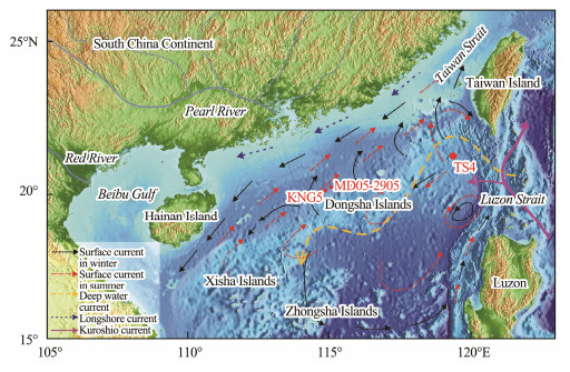
2 Materials and Methods 2.1 Sample CollectionCore TS4 (2800 m water depth; 534 cm long) was recovered in the southwestern Taiwan Basin (Fig.1). The lithology of core TS4 is mainly dark green gray clay silt. Samples were taken at 1 cm intervals for grain size analyses, 2 cm intervals for geochemical element analyses and 10 cm intervals for clay mineral analyses. The samples were also used for AMS14C dating to reconstruct the age model.
|
Fig. 1 Bathymetric and geographical location map of core TS4 (currents from Liu et al., 2010a). |
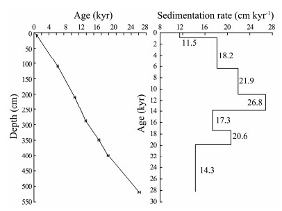
Single species of planktonic foraminifera from seven horizons were selected and measured at the Beta Analytic Inc. (Miami, USA) by using accelerator mass spectrometry (AMS). The radiocarbon ages were corrected for a local reservoir age of 61 ± 78 years (Yoneda et al., 2007). The seven AMS14C data were calibrated to the calendar year before present (cal BP), by using the Calib Rev. 7.0.4 software (Stuiver et al., 2016) with the updated age calibration curve of Marine13 (Reimer et al., 2013) (Table 1).
|
|
Table 1 AMS14C ages of core TS4 sediments |
A total of 534 core sediment samples (average interval of 1 cm) were used for grain size analysis. Some sediment sample was placed in a beaker, to which 15 mL of H2O2 was added to remove the organic matter; approximately 5 mL of 0.25 mol L−1 HCl was then added to remove the calcium carbonate. Each sample was subjected to two repeated tests with an error of < 3% (range: 0.02 – 2000 μm). The sizes of the grains were then measured using a laser grain size analyzer (Mastersizer2000, Malvern Panalytical Ltd., UK) at the Key Laboratory of Submarine Geosciences and Prospecting Techniques at the Ocean University of China. The grain size parameters were calculated by the graphic method, and the sediment types were assigned using the Shepard method.
2.4 Geochemical Element AnalysesA total of 266 sediment samples from the core TS4 (intervals of 2 cm) were used for geochemical element analyses. The organic-free samples were dried and ground, and the tetra-acid digestion method was then used. HNO3– HF–HClO4–HCl was added to the samples in sequence; the resultant solution was tested after the reaction was completed. Furthermore, the reference standard GSD-9 was measured to confirm the accuracy of the analyses. The major element compositions were determined by an inductively coupled plasma atomic emission spectrometer (ICP-AES), and the REEs were determined with an inductively coupled plasma mass spectrometer (ICP-MS). The experimental error was within 5%. The samples were tested in the laboratory of Aoshi Analysis and Testing Co., Ltd. (Guangzhou).
2.5 Clay Mineral AnalysesThe samples from the core TS4 (10 cm intervals) for clay minerals were analyzed on the oriented flake of clay powder (< 2 μm) by the X-ray diffraction (XRD) method. The tests were performed in the Public Laboratory of the Qingdao Institute of Bioenergy and Process at the Chinese Academy of Sciences. At first, H2O2 was used to remove organic matter before analysis. The samples were then washed with deionized water and centrifuged to extract the clay components with grain sizes < 2 μm according to the Stoke sedimentation principle. Next, the oriented flakes were made and soaked in ethylene glycol steam for 48 h to ensure saturation. The contents of four major clay minerals (smectites, illite, kaolinite, and chlorite) were calculated according to Biscaye's method (Biscaye, 1965). The relative content was used as the basic data and was calculated by the peak area of the three characteristic peaks for the four minerals: smectite (17 Å), illite (10 Å), chlorite and kaolinite (7 Å) on the ethylene glycol saturated map, with intensity factors of 1, 4, and 2. The content ratio of chlorite and kaolinite was calculated by the ratio of the diffraction peak areas at approximately 3.54 Å/3.57 Å with 2θ of 25˚. The error was estimated to be less than 5% for the relative abundance of each clay mineral. The illite crystallinity was expressed as the full width at half maximum of the 10 Å peak. The illite chemical index was estimated from the 5 Å/10 Å peak areas (Esquevin, 1969).
3 Results 3.1 ChronologyIn this study, we established the age framework through the linear interpolation and extrapolation method (Fig.2). The seven AMS14C dating samples used to establish the age framework did not have age reversals. The average sedimentation rates during the Holocene and the last glacial period were 19.7 and 17.6 cm kyr−1, respectively. The highest sedimentation rate occurred during 13.8 – 10.9 kyr, with a value of 26.8 cm kyr−1.
|
Fig. 2 Depth versus calibrated radiocarbon age and sedimentation rate plots for core TS4. The linear sedimentation rates (LSR) are shown for each interval in cm kyr−1. |
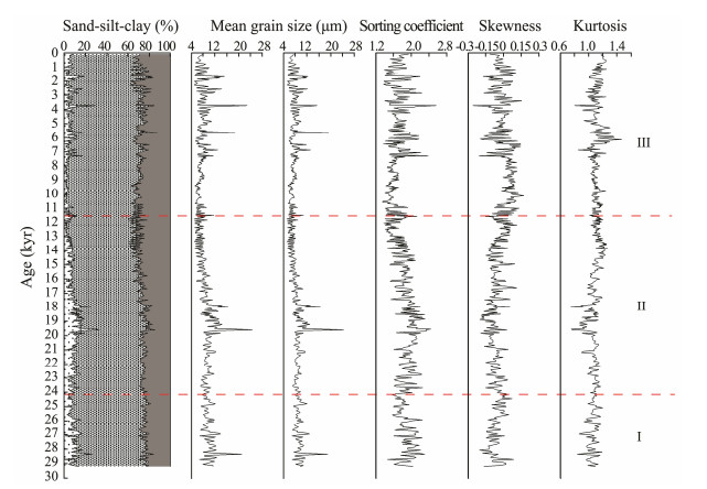
The terrigenous components in the core TS4 are mostly silt (50% – 75%) and clay (12% – 39%), with a small amount of sand (< 10%) (Fig.3). The grain size compositions has been evaluated in three stages: 29 – 24 kyr, 24 – 11.5 kyr, and 11.5 kyr. The period of Stage Ⅱ presents a slight increase in sand, a gradual decrease in silt relative to the Stage Ⅰ. In Stage Ⅲ, the grain size composition is generally stable. The mean grain size of sediments in core TS4 varies between 5 and 24 μm. In general, the sediments of Stage Ⅱ are coarser, with a mean grain size of 9 μm, while the sediments during Stage Ⅲ are finer, with an average size of 7 μm. The sorting of sediments was generally good except those deposited during 23 – 18 kyr. The data were normal distribution during 11.5 to 7.2 kyr, whereas those for the other horizons were negatively skewed.
|
Fig. 3 Vertical variation of composition and grain size parameters for sediments in core TS4. |
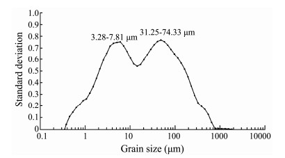
The standard deviation algorithm was used to analyze the grain size compositions of sediments from the core TS4. The variation curve of the standard deviation for each grain size component was obtained. The grain size fractions with larger standard deviations were in the ranges of 3.28 – 7.81 and 31.25 – 74.33 μm (Fig.4). Particles in the size range of 3.28 – 7.81 µm are primarily clay and fine silt, whereas the fine-grained sediments in the SCS are principally input from rivers (Wehausen and Brumsack, 2002); thus the content change of the 3.28 – 7.81 µm component can indicate the river carrying capacity and terrigenous sediments input. When the sea level decreases, the distance between the estuary and the study area is shortened, and particles in the size range of 31.25 – 74.33 μm are more easily transported to the study area. Additionally, the strong winter monsoon could also take the coarse-grained sediments which exposed on the continental shelf to the study area during the last glacial period (Yang et al., 2007).
|
Fig. 4 Grain size standard deviation distribution of core TS4 sediments. |
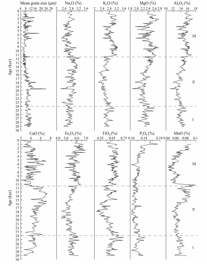
The major elements of core sediment (TS4) consist mainly of Al2O3 (11.08% – 17.14%), TFe2O3 (4.47% – 6.91%), CaO (2.27% – 7.28%), MgO (1.87% – 2.77%), Na2O (2.21% – 3.23%), and K2O (2.22% – 3.27%) with low content of TiO2 (0.52% – 0.75%), MnO (0.04% – 0.09%), and P2O5 (0.10% – 0.17%) (Fig.5). The contents of Al2O3, K2O, TFe2O3, MgO, and TiO2 show same variation patterns. Similarly, all major element compositions have been evaluated in three stages since the last glacial period. The major elemental contents in the sediment samples from core TS4 – except CaO, P2O5, and MnO – exhibited a trend of decrease upward at first, followed by an increase upward then.
|
Fig. 5 Vertical variation of major element contents in the sediments from core TS4. |
The software SPSS 22.0 was used to perform R-type factor analysis on the major element data determined from the core TS4 samples. Based on the geochemical properties of major elements and the causes of element combinations, the factors determined by the R-type factor analysis were assigned a geological significance, and the element combinations representing different material sources were determined.
With a cumulative variance contribution of 85%, the R-type factor analysis yielded three factors (Table 2). Factor 1 (F1) had the largest variance contribution (47.74%) and the most important effect on the major elemental composition of the sediment samples. F1 involved a combination of Al2O3, K2O, TFe2O3, MgO, and TiO2, which all have positive loadings. The downcore variations in Al2O3, K2O, TFe2O3, MgO, and TiO2 were almost synchronous. Al, K, Fe, and Mg are often incorporated into silicates, including clay minerals and quartz, with small amounts in heavy minerals. In the SCS sediments, studies have reported that K and Al were primarily present in illite, whereas Fe and Mg were primarily concentrated in smectites and chlorite (Xie et al., 2014; Wan et al., 2017). Al, K, Fe, and Mg are easily enriched in weathering products, especially in clay minerals. The F1 score is related to the relative contributions of terrigenous and marine biogenic materials and can be used to indicate the relative input flux of terrigenous sediments. Factor 2 (F2) was associated with positive loading of Na and Ca, and the variance contribution of F2 was 23.19%. Na and Ca are common elements in plagioclase and clay minerals. Factor 3 (F3) in the present study involved the positive Mn loading, and the variance contribution of the F3 was 13.92%. Mn is a representative element to indicate the early diagenesis of seafloor sediments (Meng et al., 2011).
|
|
Table 2 Factor loadings for major element compositions of core TS4 sediments |
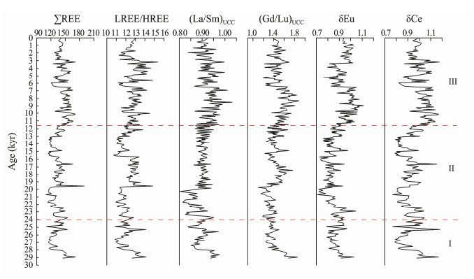
The downcore variations of all REE parameters are generally consistent, which showed the higher value since 11.5 kyr (Fig.6). The ranges and averages of the ΣREEs, LREE/HREE, (La/Sm)UCC, and (Gd/Lu)UCC were 109.35 – 189.84 and 137.75 μg g−1, 10.718 – 15.364 and 12.385 μg g−1, 0.804 – 1.032 and 0.912 μg g−1, and 1.098 – 1.883 and 1.461 μg g−1, respectively. The values of δEu and δCe varied between 0.707 – 1.113 and 1.765 – 1.354 μg g−1, respectively.
|
Fig. 6 Vertical variation of REE parameters for core TS4 sediments. |
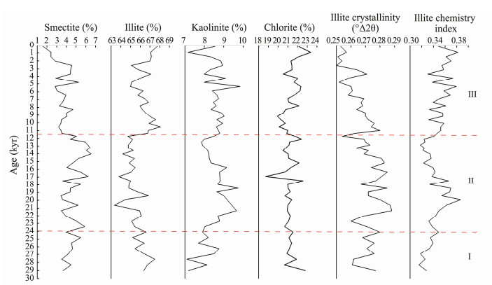
The clay mineral assemblage in core TS4 is composed of abundant illite (63% – 68%) and a few chlorite (18% – 23%), with a small amount of kaolinite (7% – 11%) and smectite (1% – 6%) (Fig.7). Clay mineral compositions have also evolved in the same three stages. The contents of chlorite do not change much. The contents of illite and smectite change little from the Stage Ⅰ to the Stage Ⅱ. In the Stage Ⅲ the sediments show higher illite and lower smectite contents than Stage Ⅱ. Kaolinite has the highest content values during 22 – 16 kyr. The illite crystallinity and illite chemistry index showed opposite trends.
|
Fig. 7 Vertical variation of the contents of clay minerals in core sediments (TS4). |
The principal rivers on the Taiwan Island annually transport 1.8×10⁸ – 3.8×10⁸ t sediment (Dadson et al., 2003), which is an important source for the surrounding sea. The annua suspended sediment transported by the Pearl River to the SCS accounts for nearly 14% of the terrigenous sediments supply (Milliman and Meade, 1983) and is also the principal source of sediments in the northern South China Sea, as confirmed by studies on the sediments from ODP sites 1144 and 1145. The Luzon Island volcano and other volcanic activity also provide sediments for the northern SCS by the branch of the Kuroshio Current. The sediments from the Luzon River generally deposited to the northwest of Luzon and not be significantly transported on the northern shelf by the branch of the Kuroshio Current (Liu et al., 2011). It is unknown if the sediments of the Yangtze River can be transported via coastal currents to the northern SCS (Wan et al., 2007b). The Yangtze River sediments may be affected by the Kuroshio and Taiwan warm currents in the process of transport southward. Moreover, the Taiwan Strait was basically closed during the LGM, cutting off the primary transportation channel of the Yangtze River sediment and making sediment transport to the study area difficult. Other large rivers, such as the Mekong, are far from the study area, and the input of the Red River sediments is blocked by the Hainan Island. According to previous studies, terrigenous sediments in the Southwestern Taiwan Basin are primarily derived from the Pearl River, Taiwan rivers, and Luzon rivers (Liu et al., 2010a; Liu et al., 2013). The clay mineral assemblages and REE distribution patterns can be used to determine the sediment provenance (Liu et al., 2013).
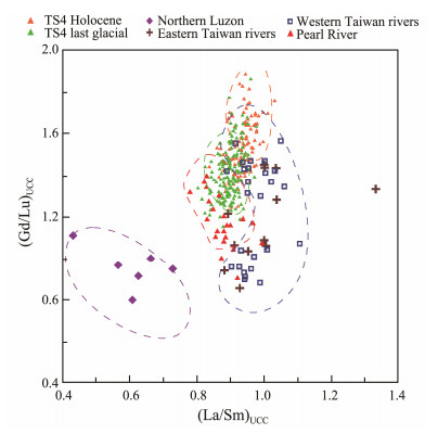
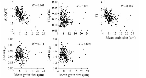
4.1.1 Evidence from REEsREEs have been widely used to determine the provenance of sediments (Cullers et al., 1975; Liu et al., 2010b; Cui et al., 2016; Huang et al., 2016). Because of the dilution effect of quartz and carbonate minerals, REEs are generally enriched in the clay and silt fraction but depleted in the sand fraction (McLennan, 1989; Vital et al., 1999). Weathering and erosion processes on the Taiwan Island are the most important mechanism of REE enrichment in the southwestern Taiwan Basin (Huang et al., 2016). The diagram of (Gd/Lu)UCC-(La/Sm)UCC for the core samples was used to distinguish the provenances of the core sediments (Fig.8). Additionally, the lack of clear correlation between the (Gd/Lu)UCC, (La/Sm)UCC, and the mean grain size (Fig.9) indicated the weak influence of grain size on REE compositions. The (La/Sm)UCC and (Gd/Lu)UCC ratios, which indicate the fractionation of the light and heavy REEs, seem to be good proxies for fluvial sediment sources. The results suggest that most of the core sediments largely overlap with those from the rivers in Taiwan, implying that these rivers might be the predominant sediment supply of the studied core sediments since 30 kyr. The sediments from the core TS4 during the last glacial period are similar to the Pearl River sediments and different from those of Luzon Island. In summary, although rivers in Taiwan are the primary sediment source, the Pearl River and Luzon might also have supplied some sediments, especially during last glacial period.
|
Fig. 8 (La/Sm)UCC-(Gd/Lu)UCC discrimination diagram. Data sources: rivers of Taiwan, Pearl River (Li et al., 2013), northern Luzon (Marini et al., 2005). |
|
Fig. 9 Correlation plots of mean grain size with REE parameters ((La/Sm)UCC and (Gd/Lu)UCC) and major elements (Al2O3 (%), TiO2/CaO, and F1). |
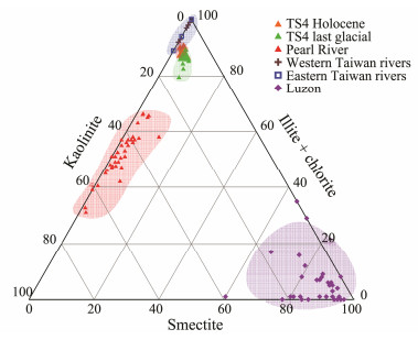
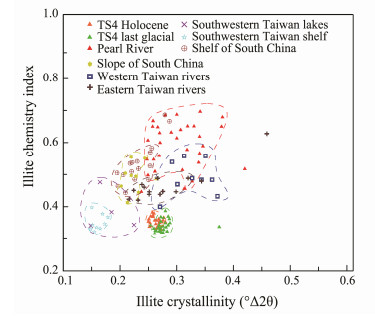
The understanding of clay mineral distribution in marine sediments requires detailed knowledge of the primary source area of each mineral and its transport processes in the ocean (Wan et al., 2007a; Steinke et al., 2008; Liu et al., 2010). This article compares the collected clay mineral data of each potential source area published by predecessors with clay mineral combination in the core TS4. Fig.10 is a ternary diagram of smectite-kaolinite-(illite + chlorite) and shows clay mineral assemblages since 30 kyr. The core sediments are clustered in a field closest to those of river sediments from Taiwan, followed by those of the Pearl River and farthest from Luzon. The sediment provenance for the sediments form core TS4 has not changed significantly from the last glacial period to the Holocene, except for a little decrease in the supply of the Pearl River. The illite chemistry index and illite crystallinity can reflect the hydrolysis conditions of illite and the source and transportation route of sediments (Krumm and Buggisch, 1991). Fig.11 shows that the illite crystallinity and illite chemistry index of sediments from core TS4 are similar to those of rivers in Taiwan, but not similar to those of lakes, slope, and shelf in South China (Liu et al., 2008). Therefore, it is reasonable to infer that illite in core TS4 is probably derived from the sediments of Taiwan rivers. The illite and chlorite in the SCS have the same spatially distributed (Liu et al., 2003; Boulay et al., 2005; Wan et al., 2007b), thereby those in the study area are primarily provided by rivers in Taiwan. Taiwan is located in a subtropical climate zone (Zhao et al., 2017a), but the illite chemistry index in river sediments is lower than that of the Pearl River Basin at almost the same latitude. This is because the crustal movement in Taiwan is relatively active. Frequent earthquakes and volcanic activities help the exposed surface rocks be washed away by the river before sufficient chemical weathering occurs. Thus, physical erosion in the area is very strong (Li et al., 2012). The illite chemistry index for sediments in the Pearl River Basin is generally greater than 0.5, indicating strong hydrolysis. Therefore, illite in the study area should not be transported by the Pearl River. The kaolinite in the sediments of the Pearl River accounts for nearly half of the total clay minerals, and the content of illite and chlorite is approximately 25%. The average content of illite and chlorite in rivers in Taiwan are 71% and 25%, respectively (Liu et al., 2007). The common feature of the clay mineral assemblages in the Taiwan and Pearl River sediment is the very low smectite content of less than 10%. The clay minerals in Luzon sediments are characterized by a high smectite content (over 85%). Previous studies suggested that the kaolinite in the northern slope of the South China Sea was primarily provided by the Pearl River (Boulay et al., 2005). In the core TS4, kaolinite content is low but slightly higher than those of sediments from rivers in Taiwan. Therefore, the Pearl River may be the primary source of kaolinite in the study area. The average content of kaolinite in the Pearl River Basin and core TS4 sediments are 45% and 9%, respectively. Assuming that all the kaolinite in the study area comes from the Pearl River, the maximum supply ratio of kaolinite in the Pearl River is 20% (Liu et al., 2007); thus, it can be inferred that the Pearl River contributes no more than 20% to the total clay minerals in the study area. Using the same method, we figured out that Luzon Island contributed no more than 4% to the clay minerals in the study area. Therefore, the rivers in Taiwan are the primary sediments source of core TS4, followed by the Pearl River; and the contribution of Luzon Island is very small. However, from the last ice age to the Holocene, the relative contributions of the Pearl River and rivers in Taiwan are unstable. According to the previous analysis, in core TS4, illite and chlorite primarily come from rivers in Taiwan, and kaolinite primarily comes from the Pearl River. Therefore (illite + chlorite)/kaolinite indicates the relative contribution of these two pathways to core TS4 sediments (Wan et al., 2010). The specific changes are discussed in detail below.
|
Fig. 10 Illite-smectite-(kaolinite + chlorite) ternary diagram. Data sources: Rivers of Taiwan (Li et al., 2012); Pearl River (Liu et al., 2007); Luzon (Liu et al., 2009). |
|
Fig. 11 Discrimination graph of illite crystallinity vs. illite chemistry index for core TS4 sediments. Data sources: Rivers of Taiwan (Li et al., 2012); South China lakes, shelf, slope and Pearl River (Liu et al., 2008). |
Ocean currents in the South China Sea include surface currents, coastal currents, deep water currents in the North Pacific, and branch of the Kuroshio Current (Fig.1). The surface ocean currents in the SCS are primarily controlled by the East Asian monsoon (Huang et al., 2016). Scholars previously believed that the seasonal wind direction change caused the surface ocean currents to flow in opposite directions in summer and winter. Subsequent further studies found that the surface ocean currents did not completely reverse their flow with monsoon changes, especially in the lower continental slope and deep sea basin (Liu et al., 2010a). The surface currents in these areas are basically the same in winter and summer. Both illite and chlorite in the South China Sea occur under the strong physical erosion conditions, and their distribution patterns in the SCS are identical (Wan et al., 2007b). Illite and chlorite are primarily transported through the deep water of the North Pacific (NPDW). The NPDW is developed on the lower continental slope (Wan et al., 2010), and the core TS4 is located at the bottom of the lower continental slope. Therefore, the sediments of the rivers in Taiwan are primarily transported by the NPDW to study area. Because the depth of the Luzon Strait (up to 2500 m) is much greater than sea level change (100 – 120 m), the deep water currents that intrude the South China Sea have remained stable during the glacial-interglacial cycle (Wan et al., 2010). Smectite is primarily transported by the branch of the Kuroshio Current.
Our results indicated that rivers in Taiwan were the major sediment contributor since 30 kyr, followed by the Pearl River; and Luzon sediments contribute little to the Southwestern Taiwan Basin, which is consistent with our REE results.
4.2 Evolution of Terrigenous Sediment Input in the Southwestern Taiwan BasinThe input of terrigenous sediment in the southwestern Taiwan Basin will be affected by sea level change and the monsoon climate. The influence of each factor is different and closely related to the regional environment (Tjallingii et al., 2019). In order to understand how these factors control the input of terrigenous sediment in the Southwest Taiwan Basin since 30 kyr, the compositions of grain size, clay minerals, and major elements are determined and discussed. Because of the relatively conservative characteristics in the weathering process, Al2O3 (%) is used in this study to indicate the input of terrigenous sediments (Yang et al., 2003; Deplazes et al., 2014). The F1 score is related to the relative contributions of terrigenous and marine biogenic material and can be used to indicate the relative input of terrigenous sediments. Higher F1 values indicate more terrigenous sediment input. The fine particles with the size of 3.28 – 7.81 μm are transported by the rivers, which can also indicate the input of terrigenous sediments. Ti is believed to primarily originate from the input of terrigenous sediments (Chen et al., 2013; Li et al., 2017). In addition to protolith weathering, a considerable part of CaO comes from biogenic input. The TiO2/CaO ratio is used to reflect the relative contribution of terrigenous sediment input and biogenic input (Tjallingii et al., 2010; Clift et al., 2014; Chang et al., 2015).
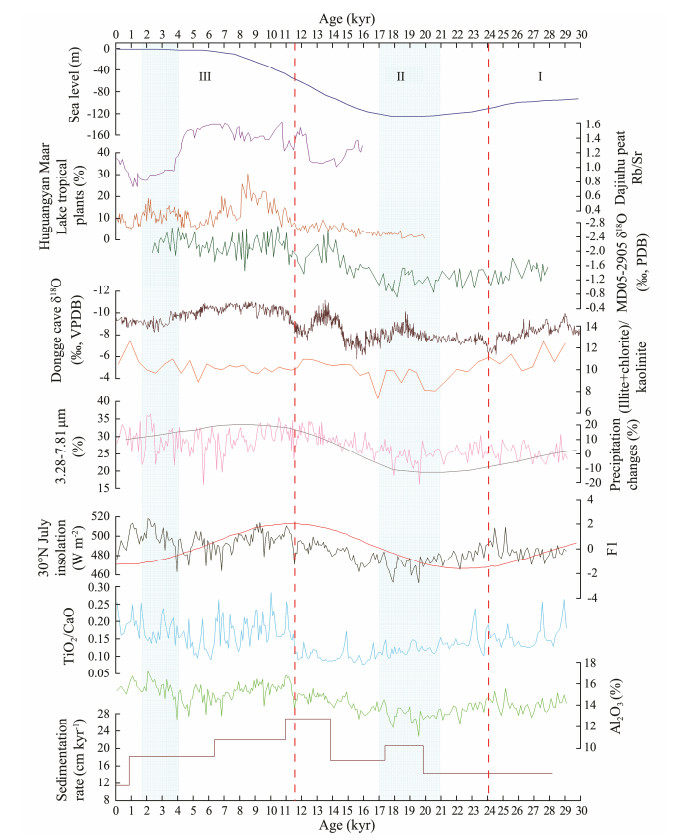
Higher and lower TiO2/CaO ratios indicate increased and decreased terrigenous sediment input in the study area, respectively. Meanwhile, the weak correlation between the Al2O3 (%), TiO2/CaO, F1 factor scores, and the mean grain size (Fig.9) indicated a weak influence of grain size on major element compositions. The Taiwan Island is influenced by strong tectonic activity and heavy monsoon/typhoon rainfall, resulting in strong physical denudation. Illite and chlorite from rivers in Taiwan indicate strong physical weathering, and their clay mineral species do not represent glacial/interglacial change (Liu et al., 2008; Liu et al., 2010a). The primary source of sediments in the core TS4 is rivers in Taiwan, followed by the Pearl River. Illite and chlorite are primarily transported by rivers in Taiwan, and kaolinite is primarily input by the Pearl River; therefore, (illite + chlorite)/kaolinite indicates the relative contribution of the two pathways. In summary, this study used Al2O3 (%), the F1 score, the contents of particles in the size range of 3.28 – 7.81 μm, and TiO2/CaO to indicate the variation of terrigenous sediment input. Based on these proxies recorded in core TS4, we suggest a threestage evolution of terrigenous sediment input since 30 kyr in the southwestern Taiwan Basin (Fig.12).
|
Fig. 12 Terrigenous sediment input variation recorded by different proxies in core TS4, compared with the variation of Dongge cave δ18O (Yuan et al., 2004), sea level change curve (Guo, 1979), July insolation at 30˚N (Berger and Loutre, 1991), core MD05-2905 δ18O (Liu et al., 2016), precipitation changes (Sanyal and Sinha, 2010), Dajiuhu peat Rb/Sr (Ma et al., 2008), and Huguangyan Maar Lake tropical plants (Sheng et al., 2017). |
Stage Ⅰ (29 – 24 kyr): Al2O3 (%), F1 score, and TiO2/CaO present high values, indicating more terrigenous sediment input during this period. The terrigenous sediment in the Southwestern Taiwan Basin is primarily derived from rivers. The late MIS3 period was a weak warm period with a slightly strengthened East Asian summer monsoon (Zheng et al., 2008), which brought abundant precipitation and high river discharge. Thus, the input of terrigenous sediment increased during this time.
Stage Ⅱ (24 – 11.5 kyr): The value of Al2O3 (%), F1 score, and TiO2/CaO continued to decrease, indicating that the terrigenous sediment input in the study area continued to decrease until reaching the minimum during the last glacial maximum (LGM, 21 – 17 kyr) (Chang et al., 2015). Many cores in the northern South China Sea indicate that terrigenous sediment input increased rapidly during the LGM because of the short distance between the estuary and the study sites caused by low sea level (Huang et al., 2013; Tjallingii et al., 2019). However, the terrigenous sediments input in core TS4 during this period showed the opposite trend, indicating that the primary controlling factor of the terrigenous sediment input in the core TS4 is not sea level change. The discussion above shows that rivers in Taiwan are the primary contributor to terrigenous sediments in the southwestern Taiwan Basin, followed by the Pearl River. Because the continental shelf of Taiwan is very narrow, sea level changes do not significantly impact the location of rivers and estuaries (Huang et al., 2016). During the LGM, the source area was dry and cold, and the average annual precipitation in southeastern China and river flow into the sea were lower (Han et al., 2009). Therefore, fewer terrigenous sediments were directly input from the river into study area, which is confirmed by the decreased content of particles in the 3.28 – 7.81 μm size range. The reduction in terrigenous sediment input during this period should be caused by the weakening of the East Asian summer monsoon. It may be due to the sampling interval that the sedimentation rate did not show the lowest value during this period. Meanwhile, because of the short distance between the Pearl River Estuary and the core location during this period, more coarse-grained sediments were transported to the study area, and the grain size sorting became worse. The ratio of (illite + chlorite)/kaolinite was minimum during this period, indicating that when the total input of terrigenous sediment decreased, the relative contributions of rivers in Taiwan and the Pearl River also changed. Previous analysis showed that the input of terrigenous sediments from rivers in Taiwan controlled the basic compositions of sediments in the core. However, the distance between the Pearl River Estuary and the core location was shortened during this period, increasing the input of terrigenous sediments from the Pearl River. The trend of the overall input of terrigenous sediments does not change, but the proportion of terrigenous sediments from the Pearl River increased relative to the rivers in Taiwan.
During the last deglaciation period, the climate began to become warm and humid, and rainfall increased in the source area (Dou et al., 2011). Accordingly, the loading capacity of rivers to terrigenous sediments increased. During 17 – 11.5 kyr, the value of the Al2O3 (%) and F1 scores gradually increased, indicating the increase of terrigenous sediment input. The value of (illite + chlorite)/kaolin also gradually increased, indicating the increase of terrigenous sediment input from the rivers in Taiwan relative to that from the Pearl River. Rapid sea level rise and the retreat of the Pearl River Estuary reduced the input of terrigenous sediment from the Pearl River. However, the summer monsoon strengthened, resulting in the increase of terrigenous sediment input from the Pearl River. The impact of sea level rise on the sediment contribution of the Pearl River was greater than the adverse effect of enhanced transportation capacity because of monsoon (Huang et al., 2013). Therefore, the overall terrigenous sediment input from the Pearl River is steadily decreasing. Because sea level change barely affects the distance between the estuaries of rivers in Taiwan and the study area, the strengthened summer monsoon increases the transport flux of terrigenous sediment by rivers in Taiwan. Therefore, the relative contribution of Taiwan sediments continued to increase during the last deglaciation period.
During stage Ⅲ (11.5 kyr –): In this period, the terrigenous sediment input showed a trend of decreasing at first and then increasing, higher than those in the first and second stages. During 11.5 –7.2 kyr, Al2O3 (%), F1 score, and TiO2/CaO are all at high values, indicating that the input of terrigenous sediments increased during this period (the Holocene Optimum), which featured a strong East Asian summer monsoon in the early Holocene. Shi and Kong (1992) proposed the earliest Holocene Optimum, from approximately 8.5 to 3 kyr, a result verified in many lakes across the country. An et al. (2000) reanalyzed the published Holocene paleoclimatic data and found that the Holocene Optimum was asynchronous in the Chinese monsoon region, starting later and later from the northwest (10 kyr) to southeast (5.0 –3.0 kyr). However, in recent years, studies have found that the period during 10.5 – 6.5 kyr had the highest humidity during the Holocene (Zhang et al., 2011), and the East Asian monsoon gradually strengthened northward in the early Holocene and gradually retreated southward in the late Holocene. According to this analysis, Holocene Optimum in southern China is relatively long. More researches showed that the Holocene Optimum appeared in the early Holocene in southern China (Wang et al., 2016; Zhao et al., 2017b). Through the study of the sediments in the northern slope of the SCS, terrestrial weathering intensity was found to have been increasing during the early Holocene, while the grain size was becoming finer. This period of strong weathering occurred during 11 – 8 kyr (Hu et al., 2012). The high value of the sensitive 2 – 9 μm component in core MD05-2905 appears in 11.2 – 8.5 kyr; thus, the summer monsoon was strongest during 11.2 – 8.5 kyr (Yang et al., 2008). The sensitive components and geochemical proxies determined for the core KNG5 also indicated that the strongest weathering period was from 11.5 to 8 kyr during the early Holocene (Huang et al., 2011, 2016). The Rb/Sr of Dajiuhu peat and the pollen records of tropical plants in Huguangyan Maar Lake also indicate that the climate was warm and humid, and the East Asian summer monsoon strengthened during this period (Ma et al., 2008; Sheng et al., 2017). At the same time, the chemical weathering intensity in the source area increased, the core TS4 sediment became finer and the sorting became better, with a normal distribution in grain size during this period. In summary, the records in the southern China continent and the South China Sea indicate that the Holocene Optimum occurred during the period of 11.5 – 8 kyr. The extremely strong East Asian summer monsoon inevitably brought abundant precipitation, which increased the discharge and loading capacity of rivers. Therefore, the input of terrigenous sediments during this period was the highest in the past 30 kyr.
After 7.2 kyr, according to the evolution of the East Asian summer monsoon reflected by the stalagmites of Dongge Cave and sediments from the core MD05-2905 (Liu et al., 2016), the East Asian summer monsoon continued to weaken, and the input of terrigenous sediments in the study area continued to decrease. It is worth noting that during the period of 4 – 1.8 kyr, all proxies showed significantly high values, indicating increased terrigenous sediment input during this period. This increase may be related to abnormal rainfall. The anomalous phenomenon of rainfall in mainland China is often related to ENSO, and modern observations show that during ENSO, the middle and lower reaches of the Yangtze River often receive continuous heavy rainfall (Liao et al., 1999). Long-term statistical data and climatic dynamics studies also prove that the probability of heavy precipitation in the Yangtze River Basin increases during ENSO events (Huang et al., 1998). During strong ENSO periods, the combined effect of the unusually low anticyclone in the Philippine Sea and the weak mid-latitude frontal system intruding into the eastern China coastal area cause frequent rainfall on the Taiwan Island (Chen et al., 2003; Jiang, 2003). The studies on the ENSO model and coral records show that ENSO was strongly enhanced during 3.5 – 1.7 kyr (Liu et al., 2000; Gagan et al., 2004). The abnormally heavy rainfall brought by ENSO on the one hand enhanced the transport capacity of the rivers, on the other hand enhanced the erosion of the source area, especially on the Taiwan Island. Under the combined impact of these two factors, the flux of the river sediments into the sea increased. Thus, the increase of terrigenous sediment input during 4.0 – 1.8 kyr may be related to the enhanced ENSO activity.
In summary, the terrigenous sediment input in the study area is primarily controlled by the evolution of the East Asian summer monsoon and partly by the ENSO activity. Sea level change does not affect the overall trend of terrigenous sediments input, but it changes the relative contributions of rivers in Taiwan and the Pearl River.
5 ConclusionsIn this study the compositions of grain size, clay minerals, and geochemical elements in sediments from core TS4 has been investigated to reconstruct the sediment provenance and terrigenous sediment input evolution in the southwestern Taiwan Basin over past 30 kyr. Variations in terrigenous sediment input were driven by the evolution of the East Asian summer monsoon. The following conclusions can be drawn from this study:
1) Base on REEs and clay mineral compositions, rivers in Taiwan have been the primary sediment contributors since 30 kyr, followed by the Pearl River. The Luzon Island contributes little sediments to the southwestern Taiwan Basin.
2) Three stages were identified for the terrigenous sediment input evolution on the lower continental slope in the southwestern Taiwan Basin. During stage Ⅰ, there was more terrigenous sediment input during a weak warm period with a slightly strong East Asian summer monsoon. During Stage Ⅱ, the East Asian summer monsoon continued to weaken, reaching a minimum during the Last Glacial Maximum (LGM). At this time, the input of terrigenous sediments also fell to a minimum. However, because of the low sea level during the LGM, the contribution of the Pearl River sediments increased relative to rivers in Taiwan. At 17 kyr, the climate was warming, the East Asian summer monsoon was intensifying, and the input of terrigenous sediments was beginning to increase. At this time, because of the rapid rise of sea level, the contribution of the Pearl River sediments decreased relative to that of rivers in Taiwan. During stage Ⅲ, the East Asian summer monsoon strengthened and the input of terrigenous sediments reached a maximum in the period of 11.5 – 7.2 kyr. After 7.2 kyr, the East Asian summer monsoon continued to weaken, and the input of terrigenous sediments in the study area continued to decrease. However, the input of terrigenous sediments during 4 – 1.8 kyr showed high values again because of enhanced ENSO activity.
3) The evolution of the East Asian summer monsoon is the primary controlling factor for the terrigenous sediment input in the Southwestern Taiwan Basin, and ENSO activity also has a certain impact. Sea level change does not alter the overall trend of terrigenous sediment input but does change the relative contributions of rivers in Taiwan and the Pearl River.
6 AcknowledgementsThis study was financially supported by the National Key Research and Development Program (No. 2017YFC 0306703), and the National Natural Science Foundation of China (No. 41706065).
An, Z. S., Porter, S. C., Kutzbach, J. E., Wu, X. H., Wang, S. M., Liu, X. D., Li, X. Q. and Zhou, W. J., 2000. Asynchronous Holocene Optimum of the East Asian monsoon. Quaternary Science Reviews, 19: 743-762. DOI:10.1016/s0277-3791(99)00031-1 (  0) 0) |
Berger, A. and Loutre, M. F., 1991. Insolation values for the climate of the last 10 million years. Quaternary Science Reviews, 10: 297-317. DOI:10.1016/0277-3791(91)90033-Q (  0) 0) |
Biscaye, P. E., 1965. Mineralogy and sedimentation of recent deepsea clay in the Atlantic Ocean and adjacent seas and oceans. Geological Society of America Bulletin, 76(7): 803-832. DOI:10.1130/0016-7606(1965)76[803:MASORD]2.0.CO;2 (  0) 0) |
Boulay, S., Colin, C., Trentesaux, A., Frank, N. and Liu, Z. F., 2005. Sediment sources and East Asian monsoon intensity over the last 450 ky. Mineralogical and geochemical investigations on South China Sea sediments.. Palaeogeography, Palaeoclimatology, Palaeoecology, 228(3-4): 260-277. DOI:10.1016/j.palaeo.2005.06.005 (  0) 0) |
Cai, G. Q., Peng, X. C., Chen, H. J., Zhang, J. P. and Zhang, Y. L., 2012. The component characteristics and paleoenvironmental significances for sediments in core 83PC from the Xisha Trough, South China Sea. Marine Geology and Quaternary Geology, 1: 81-88 (in Chinese with English abstract). (  0) 0) |
Chang, F. M., Li, T., Xiong, Z. and Xu, Z., 2015. Evidence for sea-level and monsoonal driven variations in terrigenous input to the northern East China Sea during the last 24. 3 ka. Paleoceanography, 30: 642-658. DOI:10.1002/2014PA002733 (  0) 0) |
Chen, G. T. J., Jiang, Z. H. and Wu, M. C., 2003. Spring heavy rain events in Taiwan during warm episodes and the associated large-scale conditions. Monthly Weather Review, 131: 1173-1188. DOI:10.1175/1520-0493(2003)131<1173:SHREIT>2.0.CO;2 (  0) 0) |
Chen, H. F., Yeh, P. Y., Song, S. R., Hsu, S. C., Yang, T. N., Wang, Y., Chi, Z., Lee, T. Q., Chen, M. T., Cheng, C. L., Zou, J. and Chang, Y. P., 2013. The Ti/Al molar ratio as a new proxy for tracing sediment transportation processes and its application in Aeolian events and sea level change in East Asia. Journal of Asian Earth Science, 73: 31-38. DOI:10.1016/j.jseaes.2013.04.017 (  0) 0) |
Clift, P. D., Wan, S. M. and Blusztajn, J., 2014. Reconstructing chemical weathering, physical erosion and monsoon intensity since 25 Ma in the northern South China Sea: A review of competing proxies. Earth Science Reviews, 130: 86-102. DOI:10.1016/j.earscirev.2014.01.002 (  0) 0) |
Colin, C., Siani, G., Sicre, M. A. and Liu, Z., 2010. Impact of the East Asian monsoon rainfall changes on the erosion of the Mekong River Basin over the past 25, 000 yr. Marine Geology, 271: 84-92. DOI:10.1016/j.margeo.2010.01.013 (  0) 0) |
Cui, Z., Schulz-Bull, D. E., Hou, Y., Xia, Z. and Waniek, J. J., 2016. Geochemical characteristics and provenance of Holocene sediments (core STAT22) in the Beibu Gulf, South China Sea. Journal of Coastal Research, 32(5): 1105-1115. DOI:10.2112/JCOASTRES-D-14-00238.1 (  0) 0) |
Cullers, R. L., Chaudhuri, S., Arnold, B., Lee, M. and Wolf, C. W., 1975. Rare earth distributions in clay minerals and in the clay-sized fraction of the lower Permian Havensville and Eskridge shales of Kansas and Oklahoma. Geochimica et Cosmochimica Acta, 39(12): 1691-1703. DOI:10.1016/0016-7037(75)90090-3 (  0) 0) |
Dadson, S. J., Hovius, N., Chen, H., Dade, W. B., Hsieh, M., Willett, S. D., Hu, J. and Horng, M., 2003. Links between erosion, runoff variability and seismicity in the Taiwan orogen. Nature, 426(6967): 648-651. DOI:10.1038/nature02150 (  0) 0) |
Deplazes, G., Lückge, A., Stuut, J. B. and Pätzold, J., 2014. Weakening and strengthening of the Indian monsoon during Heinrich events and Dansgaard-Oeschger oscillations. Paleoceanography, 29(2): 99-114. DOI:10.1002/2013PA002509 (  0) 0) |
Dou, Y. G., Yang, S. Y., Tang, M., Liu, Z. X. and Yu, H., 2011. Using biogenic components to decipher the terrigenous input and paleoenvironmental changes over last 28 ka on the middle Okinawa Trough. Quaternary Sciences, 2: 40-47 (in Chinese with English abstract). (  0) 0) |
Esquevin, J., 1969. Influence de la composition chimique des illites sur leur cristallinité. Centre Recherche Elf Pau-SNPA, Bulletin, 3(1): 147-153. (  0) 0) |
Gagan, M. K., Hendy, E. J., Haberle, S. G. and Hantoro, W. S., 2004. Postglacial evolution of the Indo-Pacific Warm Pool and El Niño-Southern Oscillation. Quaternary International, 118-119: 127-143. DOI:10.1016/S1040-6182(03)00134-4 (  0) 0) |
Guo, X, D., 1979. Sea level changes in China since the late Pleistocene. Scientia Geologica Sinica, 4: 47-58 (in Chinese with English abstract). (  0) 0) |
Han, Y., Zhao, P. and Zhou, G. B., 2009. Modeling of impacts of regional vegetation change in China on East Asian summer rainfall under the background of the Last Glacial Maximum. Quaternary Sciences, 29(6): 1071V1077. (  0) 0) |
Hu, D. K., Böning, P., Köhler, C. M., Hillier, S., Pressling, N., Wan, S., Brumsack, H. J. and Clift, P. D., 2012. Deep sea records of the continental weathering and erosion response to East Asian monsoon intensification since 14 kyr in the South China Sea. Chemical Geology, 326-327: 1-18. DOI:10.1016/j.chemgeo.2012.07.024 (  0) 0) |
Huang, J., Li, A. C. and Wan, S. M., 2011. Sensitive grain-size records of Holocene East Asian summer monsoon in sediments of northern South China Sea slope. Quaternary Research, 75: 734-744. DOI:10.1016/j.yqres.2011.03.002 (  0) 0) |
Huang, J., Li, A. C., Wan, S. M., Xu, F. J. and Meng, Q. Y., 2013. Terrigenous input to the northern slope of the South China Sea and its controlling factor since the last phase of the Last Glacial Maximum. Oceanologia et Limnologia Sinica, 44(4): 882-889 (in Chinese with English abstract). (  0) 0) |
Huang, J., Wan, S., Xiong, Z., Zhao, D., Liu, X., Li, A. and Li, T., 2016. Geochemical records of Taiwan-sourced sediments in the South China Sea linked to Holocene climate changes. Palaeogeography, Palaeoclimatology, Palaeoecology, 441: 871-881. DOI:10.1016/j.palaeo.2015.10.036 (  0) 0) |
Huang, R. H., Xu, Y. H., Wang, P. F. and Zhou, L. T., 1998. The features of the catastrophic flood over the Changjiang River Basin during the summer of 1998 and cause exploration. Climatic and Environmental Research, 3(4): 300-313 (in Chinese with English abstract). (  0) 0) |
Jiang, Z. H., 2003. Large-scale circulation patterns associated with heavy spring rain events over Taiwan in strong ENSO and non-ENSO Years. Monthly Weather Review, 131: 1769-1782. DOI:10.1175//2561.1 (  0) 0) |
Jiwarungrueangkul, T., Liu, Z. F. and Zhao, Y. L., 2019. Terrigenous sediment input responding to sea level change and East Asian monsoon evolution since the last deglaciation in the southern South China Sea. Global and Planetary Change, 174: 127-137. DOI:10.1016/j.gloplacha.2019.01.011 (  0) 0) |
Krumm, S. and Buggisch, W., 1991. Sample preparation effects on illite crystallinity measurements: Grain size gradation and particle orientation. Metamorphic Geology, 9: 671-677. DOI:10.1111/j.1525-1314.1991.tb00557.x (  0) 0) |
Li, C. S., Shi, X. F., Gao, S. J., Chen, M. D., Liu, Y. G., Fang, X. S., Lv, H. H., Zou, J. J., Liu, S. F. and Qiao, S. Q., 2012. Clay mineral composition characteristics and material sources in Taiwan river sediments. Chinese Science Bulletin, 57: 169-177. DOI:10.1360/csb2012-57-2-3-169 (  0) 0) |
Li, C. S., Shi, X. F., Gao, S. J., Liu, Y. G., Lyu, H. H., Zou, J. J., Liu, S. F. and Qiao, S. Q., 2013. Rare earth elements in finegrained sediments of major rivers from the high-standing island of Taiwan. Journal of Asian Earth Science, 69: 39-47. DOI:10.1016/j.jseaes.2013.03.001 (  0) 0) |
Li, J. R., Liu, S. F., Feng, X. L., Sun, X. Q. and Shi, X. F., 2017. Major and trace element geochemistry of the mid-Bay of Bengal surface sediments: Implications for provenance. Acta Oceanologica Sinica, 36: 82-90. DOI:10.1007/s13131-017-1041-z (  0) 0) |
Liao, M. G., Qin, Z. and Zhao, H., 1999. The impact of El Niño and La Niña phenomena on the global climate, Chinese climate and navigation. Navigation China, 45: 55-59. (  0) 0) |
Liu, F., Yang, C. P., Chang, X. H. and Liao, Z. W., 2018. Sedimentary geochemistry properties of rare earth elements from the continental lower slope of the northeastern South China Sea over the last 20 ka and its implication for provenance. Acta Oceanologica Sinica, 40(9): 148-158 (in Chinese with English abstract). (  0) 0) |
Liu, J. G., Xiang, R., Chen, M. H., Chen, Z., Yan, W. and Liu, F., 2011. Influence of the Kuroshio Current intrusion on depositional environment in the northern South China Sea: Evidence from surface sediment records. Marine Geology, 285: 59-68. DOI:10.1016/j.margeo.2011.05.010 (  0) 0) |
Liu, J. G., Xiang, R., Chen, Z., Chen, M. H., Yan, W., Zhang, L. L. and Chen, H., 2013. Sources, transport and deposition of surface sediments from the South China Sea. Deep Sea Research, 71: 92-102. DOI:10.1016/j.dsr.2012.09.006 (  0) 0) |
Liu, Z. F., Colin, C., Huang, W., Chen, Z., Trentesaux, A. and Chen, J. F., 2007. Clay minerals in the surface sediments of the Pearl River Basin and their contribution to South China Sea sediments. Chinese Science Bulletin, 52(4): 448-456. DOI:10.1360/csb2007-52-4-448 (  0) 0) |
Liu, Z. F., Colin, C., Li, X., Zhao, Y., Tuo, S., Chen, Z., Siringan, F. P., Liu, J. T., Huang, C. Y., You, C. F. and Huang, K. F., 2010a. Clay mineral distribution in surface sediments of the northeastern South China Sea and surrounding fluvial drainage basins: Source and transport. Marine Geology, 277: 48-60. DOI:10.1016/j.margeo.2010.08.010 (  0) 0) |
Liu, Z. F., Colin, C., Trentesaux, A. and Blamart, D., 2005. Clay mineral records of East Asian monsoon evolution during late Quaternary in the southern South China Sea. Science in China Series D – Earth Sciences, 48: 84-92. DOI:10.1360/03yd0091 (  0) 0) |
Liu, Z. Y., Kutzbach, J. and Wu, L. X., 2000. Modeling climate shift of El Niño variability in the Holocene. Geophysical Research Letters, 27: 2265-2268. DOI:10.1029/2000GL011452 (  0) 0) |
Liu, Z. F., Li, X. J., Colin, C. and Ge, H. M., 2010b. A highresolution clay mineralogical record in the northern South China Sea since the Last Glacial Maximum, and its time series provenance analysis. Chinese Science Bulletin, 55(29): 4058-4068. (  0) 0) |
Liu, Z. F., Trentesaux, A., Clemens, S. C., Colin, C., Wang, P., Huang, B. and Boulay, S., 2003. Clay mineral assemblages in the northern South China Sea: Implications for East Asian monsoon evolution over the past 2 million years. Marine Geology, 201: 133-146. DOI:10.1016/S0025-3227(03)00213-5 (  0) 0) |
Liu, Z. F., Tuo, S. T., Colin, C., Liu, J. T., Huang, C. Y., Selvaraj, K., Chen, C. T. A., Zhao, Y. L., Siringan, F. P., Boulay, S. and Chen, Z., 2008. Detrital fine-grained sediment contribution from Taiwan to the northern South China Sea and its relation to regional ocean circulation. Marine Geology, 255(3-4): 149-155. DOI:10.1016/j.margeo.2008.08.003 (  0) 0) |
Liu, Z. F., Zhao, Y., Colin, C., Siringan, F. P. and Wu, Q., 2009. Chemical weathering in Luzon, Philippines from clay mineralogy and major-element geochemistry of river sediments. Geochemistry, 24: 2195-2205. DOI:10.1016/j.apgeochem.2009.09.025 (  0) 0) |
Liu, Z. F., Zhao, Y. L., Colin, C., Stattegger, K., Wiesner, M. G., Huh, C., Zhang, Y., Li, X. and Li, Y., 2016. Source-to-sink transport processes of fluvial sediments in the South China Sea. Earth Science Reviews, 153: 238-273. DOI:10.1016/j.earscirev.2015.08.005 (  0) 0) |
Liu, Z. F., Zhao, Y. L., Wang, Y. J. and Chen, Q., 2017. Clay mineralogical proxy of the East Asian monsoon evolution during the Quaternary in the South China Sea. Quaternary Science, 37(5): 921-933 (in Chinese with English abstract). (  0) 0) |
Ma, C. M., Zh, u., C, ., Zheng, Z. G., Yin, Q. and Zhao, Z. P., 2008. Climate changes in East China since the late-glacial inferred from high-resolution mountain peat humification records. Science in China Series D – Earth Science, 38(9): 1078-1091. (  0) 0) |
Marini, J. C., Chauvel, C. and Maury, R. C., 2005. Hf isotope compositions of northern Luzon arc lavas suggest involvement of pelagic sediments in their source. Contributions to Mineralogy & Petrology, 149: 216-232. DOI:10.1007/s00410-004-0645-4 (  0) 0) |
McLennan, S. M., 1989. Rare earth elements in sedimentary rocks: Influence of provenance and sedimentary processes. Reviews in Mineralogy and Geochemistry, 21: 169-200. (  0) 0) |
Meng, X. W., Xia, P., Zhang, J. and Wang, X. Q., 2011. Evolution of the East Asian monsoon and its response to uplift of the Tibetan Plateau since 1. 8 Ma recorded by major elements in sediments of the South China Sea. Chinese Science Bulletin, 56(34): 547-551. (  0) 0) |
Milliman, J. D. and Meade, R. H., 1983. World-wide delivery of river sediment to the oceans. The Journal of Geology, 91: 1-21. DOI:10.1086/628741 (  0) 0) |
Reimer, P. J., Bard, E., Bayliss, A., Beck, J. W., Blackwell, P. G., Ramsey, C. B., Brown, D. M., Buck, C. E., Edwards, R. L., Friedrich, M., Grootes, P. M., Guilderson, T. P., Haflidason, H., Hadjas, I., Hatte, C., Heaton, T. J., Hogg, A. G., Hughen, K. A., Kaiser, K. F., Kromer, B., Manning, S. W., Reimer, R. W., Richards, D. A., Scott, E. M., Southon, J. R., Turney, C. S. M. and Plicht, J. V. D., 2013. Selection and treatment of data for radiocarbon calibration: An update to the international calibration (IntCal) criteria. Radiocarbon, 55: 23. (  0) 0) |
Sanyal, P. and Sinha, R., 2010. Evolution of the Indian summer monsoon: Synthesis of continental records. Geological Society London Special Publications, 342(1): 153-183. DOI:10.1144/SP342.11 (  0) 0) |
Sheng, M., Wang, X. S., Zhang, S. Q., Chu, G. Q., Su, Y. L. and Yang, Z. Y., 2017. A 20, 000-year high-resolution pollen record from Huguangyan Maar Lake in tropical-subtropical South China. Palaeogeography, Palaeoclimatology, Palaeoecology, 472: 83-92. DOI:10.1016/j.palaeo.2017.01.038 (  0) 0) |
Shi, Y. F. and Kong, Z. C., 1992. The Climates and Environments of Holocene Megathermal in China. China Ocean Press, Beijing, 1-8.
(  0) 0) |
Steinke, S., Hanebuth, T. J. J., Vogt, C. and Stattegger, K., 2008. Sea level induced variations in clay mineral composition in the southwestern South China Sea over the past 17, 000 yr. Marine Geology, 250: 199-210. DOI:10.1016/j.margeo.2008.01.005 (  0) 0) |
Stuiver, M., Reimer, P. J., and Reimer, R. W., 2016. CALIB 7.1 [WWW program] at. http://calib.org (accessed 2016-8-10).
(  0) 0) |
Tjallingii, R., Stattegger, K., Wetzel, A. and Phung, V. P., 2010. Infilling and flooding of the Mekong River incised-valley system during deglacial sea-level rise. Quaternary Science Reviews, 29: 1432-1444. DOI:10.1016/j.quascirev.2010.02.022 (  0) 0) |
Vital, H., Stattegger, K. and Garbe-Schonberg, C. D., 1999. Composition and trace-element geochemistry of detrital clay and heavy-mineral suites of the lowermost Amazon River: A provenance study. Journal of Sedimentary Research, 69: 563-575. DOI:10.2110/jsr.69.563 (  0) 0) |
Wan, S. M., Clift, P. D., Zhao, D. B., Hovius, N., Munhoven, G., France-Lanord, C., Wang, Y. X., Xiong, Z. J., Huang, J., Yu, Z. J., Zhang, J., Ma, W. T., Zhang, G. L., Li, A. C. and Li, T. G., 2017. Enhanced silicate weathering of tropical shelf sediments exposed during glacial lowstands: A sink for atmospheric CO2. Geochimica et Cosmochimica Acta, 200: 123-144. DOI:10.1016/j.gca.2016.12.010 (  0) 0) |
Wan, S. M., Li, A. C., Clift, P. D. and Stuut, J. B. W., 2007a. Development of the East Asian monsoon: Mineralogical and sedimentologic records in the northern South China Sea since 20 Ma. Palaeogeography, Palaeoclimatology, Palaeoecology, 254: 561-582. DOI:10.1016/j.palaeo.2007.07.009 (  0) 0) |
Wan, S. M., Li, A. C., Clift, P. D., Wu, S. G., Xu, K. H. and Li, T. G., 2010. Increased contribution of terrigenous supply from Taiwan to the northern South China Sea since 3 Ma. Marine Geology, 278: 115-121. DOI:10.1016/j.margeo.2010.09.008 (  0) 0) |
Wan, S. M., Li, A. C., Stuut, J. B. W. and Xu, F. J., 2007b. East Asian monsoon evolution revealed by the granularity of station ODP1146 in the northern South China Sea in the past 20 Ma. Science China – Earth Sciences, 37(6): 761-770. (  0) 0) |
Wang, X. S., Chu, G. Q., Sheng, M., Zhang, S. Q., Li, J. H., Chen, Y., Tang, L., Su, Y. L., Pei, J. L. and Yang, Z. Y., 2016. Millennial-scale Asian summer monsoon variations in South China since the last deglaciation. Earth and Planetary Science Letters, 451: 22-30. DOI:10.1016/j.epsl.2016.07.006 (  0) 0) |
Wehausen, R. and Brumsack, H. J., 2002. Astronomical forcing of the East Asian monsoon mirrored by the composition of Pliocene South China Sea sediments. Earth and Planetary Science Letters, 201(3-4): 621-636. DOI:10.1016/S0012-821X(02)00746-X (  0) 0) |
Xie, X., Zheng, H. B. and Qiao, P. J., 2014. Millennial climate changes since MIS 3 revealed by element records in deep-sea sediments from northern South China Sea. Chinese Science Bulletin, 59: 776-784. DOI:10.1007/s11434-014-0117-9 (  0) 0) |
Yang, S. Y., Ju, ng, H,, S, ., Lim, D. I. and Li, C. X., 2003. A review on the provenance discrimination of the Yellow Sea sediments. Earth Science Reviews, 63(1): 93-120. (  0) 0) |
Yang, W. G., Zheng, H. B., Wang, K., Xie, X., Chen, G. C. and Mei, X., 2007. Sedimentary characteristic of terrigenous clast of site MD05-2905 in the northeastern part of South China Sea after 36 ka and evolution of East Asian monsoon. Advances in Earth Science, 22(10): 1012-1018 (in Chinese with English abstract). (  0) 0) |
Yang, W. G., Zheng, H. B., Xie, X., Zhou, B. C. and Cheng, X. R., 2008. East Asian summer monsoon maximum records in northern South China Sea during the early Holocene. Quaternary Sciences, 28: 425-430 (in Chinese with English abstract). (  0) 0) |
Yoneda, M., Uno, H., Shibata, Y., Suzuki, R., Kumamoto, Y., Yoshida, K., Sasaki, T., Suzuki, A. and Kawahata, H., 2007. Radiocarbon marine reservoir ages in the western Pacific estimated by pre-bomb molluscan shells. Nuclear Instruments and Methods in Physics Research, 259: 432-437. DOI:10.1016/j.nimb.2007.01.184 (  0) 0) |
Yuan, D., 2004. Timing, duration, and transitions of the last interglacial Asian monsoon. Science, 304(5670): 575-578. DOI:10.1126/science.1091220 (  0) 0) |
Zhang, J. W., Chen, F. H., Holmes, J. A., Li, H., Guo, X. Y., Wang, J. L., Li, S., Lü, Y. B., Zhao, Y. and Qiang, M. R., 2011. Holocene monsoon climate documented by oxygen and carbon isotopes from lake sediments and peat bogs in China: A review and synthesis. Quaternary Science Reviews, 30: 1973-1987. DOI:10.1016/j.quascirev.2011.04.023 (  0) 0) |
Zhao, H. Q. and Wang, P. X., 1999. Progress in Quaternary paleoceanography of the South China Sea: A review. Quaternary Science, 6: 481-501 (in Chinese with English abstract). (  0) 0) |
Zhao, L., Ma, C. M., Leipe, C., Long, T. W., Liu, K. B., Lu, H. Y., Tang, L. Y., Zhang, Y., Wagner, M. and Tarasov, P. E., 2017a. Holocene vegetation dynamics in response to climate change and human activitiesderived from pollen and charcoal records from southeastern China. Palaeogeography, Palaeoclimatology, Palaeoecology, 485: 644V660. (  0) 0) |
Zhao, Y., Yang, S., Liu, J., Fan, D., Yang, R., Bi, L. and Chang, Y. P., 2017b. Reconstruction of silicate weathering intensity and paleoenvironmental change during the late Quaternary in the Zhuoshui River catchment in Taiwan. Quaternary International, 452: 43-53. DOI:10.1016/j.quaint.2016.12.013 (  0) 0) |
Zheng, H. B., Chen, G. C., Xie, X., Mei, X., Li, J. R., Ge, H. M. and Huang, E. Q., 2008. Grain size distribution and dynamic control of late Quaternary terrigenous sediments in the South China Sea and their implication for East Asian monsoon evolution. Quaternary Sciences, 3: 414-424 (in Chinese with English abstract). (  0) 0) |
 2021, Vol. 20


