2) National Satellite Meteorological Center (National Center for Space Weather), China Meteorological Administration, Beijing 100081, China;
3) College of Oceanic and Atmospheric Sciences, Ocean University of China, Qingdao 266100, China
NOAA satellite has been operational since the 1960s. Its Advanced Very High Resolution Radiometer (AVHRR) image data, with the longest duration, have five bands, including visible, near-infrared, mid-infrared, and two thermal infrared bands. It has been widely used in examining the long-term evolution of sea surface temperature (SST), sea surface suspended matter concentration (SSC), chlorophyll, and other characteristic elements. However, systematic errors from multiple NOAA satellites, especially those from earlier satellites, have limited the accuracy of long-term studies. Previous sensors have been calibrated for each NOAA satellite (Su and Gibeaut, 2013), but only the errors caused by the attenuation of the satellite channel have been considered. In some studies, MODIS and AVHRR mutual inspection methods have also been used to verify the data and conduct offshore SST and SSC studies (Bi et al., 2011). However, limited to the observation time of the MODIS data, errors in early AVHRR data still exist. Previous studies have corrected NOAA/AVHRR data by using 'clean water' in the waters of the Yangtze Estuary in China, where suspended matter concentrations are extremely low all year-round, and obtained the inversion formula of surface suspended sediment concentrations (Li and Yun, 2001).
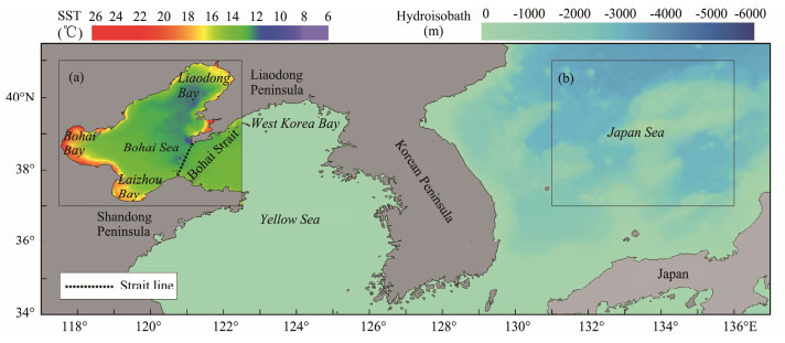
The Bohai Sea is a typical continental shelf inland sea of China (Fig.1) with an average water depth of 18 m. The rivers flowing into the Bohai Sea are mainly the Yellow River, Hai River, Luan River, and Liao River, among which the average run-off of the Yellow River constitutes approximately half of the total. Variations in the SST and SSC of the Bohai Sea are not only affected by local factors, such as the monsoon, circulation, and runoff (Huang et al., 1999; Fang et al., 2000; Xie et al., 2002; Yang et al., 2011), but also inevitably affected by global climate changes. Studies have shown that the annual variation rate of the SST in the Bohai Sea from 1960 to 2012 was 0.01℃ yr−1. It decreased from 1960 to 1987, increased after 1987, and this upward trend did not weaken until 2009 (Yang et al., 2017). Some studies have also analyzed the climate characteristics of long-term changes in the SST of China's marginal seas from 1870 to 2011. The warming trend of China's marginal seas was generally found to be higher than the global and hemispheric averages. In the study of Bao and Ren (2014), the SST characteristics in Yellow Sea and Bohai Sea, the East China Sea, and the South China Sea were demonstrated, without explaining the specific changes in the Bohai Sea. From 2003 to 2014, the SSC in the Bohai Sea decreased, which was associated with the weakening of wind speed in the Bohai Sea area, the increase in the sediment size caused by the Yellow River water and sediment regulation, and the reclamation of land in Laizhou Bay and Bohai Bay (Zhou et al., 2016). For a long time, the long-term changes in temperature, salinity, and suspended matter concentration in the Bohai Sea have attracted much attention, which was of great significance in the development of the Bohai Rim Economic Zone.
|
Fig. 1 Study area and background calibration test area. (a), 117.5˚ – 122.5˚E, 37˚ – 41˚N; (b), 131˚ – 136˚E, 37˚ – 41˚N. |
A strong precursory signal of SST anomalies has been observed in the Bohai Sea during winter (Han et al., 2014). The study illustrated the long-term variation in the SST of the Bohai Sea and Yellow Sea and proposed that it was closely related to the ENSO cycle during winter, which might affect the Bohai Sea temperature through the Yellow Sea Warm Current (Wang et al., 2020), although no clear evidence has been found. When ENSO occurs, the water mass and sea level in different regions of the western Pacific Ocean have been considered to respond to the event in varying degrees, and the SST of the China sea is also considered to increase (Wang et al., 2019). However, the relationship between the El Niño and La Niña events and the SST of the Bohai Sea has not been clarified. In addition, in the past 1500 years, the Asian monsoon and ocean circulation have dominated the sedimentary evolution of the mud area in the central Bohai Sea of China. The Arctic winter climate may have effect on the paleoenvironmental changes of the East Asian continental shelf through the remote connection between Kuroshio and ENSO (Lyu et al., 2020). In conclusion, through the monsoon and ocean currents, the Bohai SST and SSC have an internal correlation with El Niño and La Niña climate anomaly years. However, researches on the response of SST and SSC to climate anomalies in the Bohai Sea are still scarce.
In this study, the NOAA/AVHRR satellite data obtained during different periods were corrected by using the background calibration method, and the variation characteristics of SST and SSC in the Bohai Sea over the past 30 years were analyzed to examine the response mechanism of marine elements to climate changes in the Bohai Sea.
2 Data and Methods 2.1 Data SourcesThe SSC data were derived by 4 km resolution from 1985 to 1994 and 1 km from 1995 to 2018 from the AVHRR L1B database on the official website of NOAA, including NOAA-9 (Jan, 1985 – Oct, 1988), NOAA-11 (Jan, 1988 – Nov, 1994), NOAA-12 (1994 – 1996), NOAA-14 (1996 – 1999), NOAA-15 (1999 – 2000), NOAA-16 (2001 – 2005), NOAA-17 (2003 – 2006), NOAA-18 (2006 – 2008), and NOAA-19 (2009 – 2018) satellites. The SST data since 1985 had a spatial resolution of 4 km (Kilpatrick, et al., 2001). The wind speed data were the Cross-Calibrated Multi-Platform (CCMP) daily average data of the Bohai Sea from 1987 to 2018 (Wentz et al., 2015). The sediment discharge and runoff data of Yellow River were derived from the monthly average data obtained at the Lijin Hydrological Observation Station of China from 1952 to 2017. Oceanic Niño Index (ONI) data were obtained from the National Weather Service Center for Weather and Climate Prediction of America (Table 1).
|
|
Table 1 Data sources |
The method used in this study is carried out as the following steps: performing radiometric correction, geometric correction, and clipping the obtained AVHRR raw data (Brest and Rossow, 1992); removing the cloud pollution area of wave band 1 based on the characteristic values of wave band 1, the ratio of wave band 1 to 2, and wave bands 4 and 5 for four seasons (Fell et al., 2001); and overlapping the pixel values at the same position in each monthly dataset to obtain a monthly average value, and forming a surface suspended reflectivity dataset. Because the data quantity was large, the Interactive Data Language (IDL) programming was adopted during the processing, which involved transferring the software of the Environment for Visualizing Images (ENVI) function to batch processing (Che and Price, 1992; Li and Yun, 2001; Chen et al., 2002; Su and Gibeaut, 2013; Liu et al., 2016).
2.3 Background Calibration MethodIn the Bohai Sea, some data are not suitable for correction through different NOAA satellites because of the high concentrations of suspended matter and large spatial and temporal variations. Thus, selecting the sea area with extremely low SSC and minor spatial and temporal variations in the adjacent sea areas at the same latitude as the background field for calibration was necessary to obtain the data calibration relationships among different satellites. The Japan Sea, which is located at the mid-latitude adjacent sea area, has low SSC reflectivity throughout the year. The monthly variation value fluctuated slightly for the same month for many years, thus, making it be a background sea area meeting the above conditions.
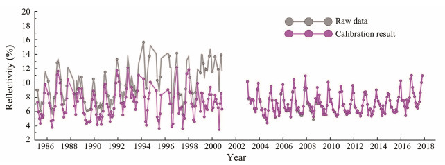
The processing results of the reflectivity data in the background sea area in the last ten years (2009 – 2018) from the NOAA-19 satellite launched recently showed that the monthly average sea surface reflectivity in this area was very low, with an average value of 7.15%. The fluctuation of reflectivity in the four seasons was less than 4%, and the difference between two monthly SSCs was significantly slight. Therefore, the multi-year average sea surface reflectance of NOAA-19 satellite in the background sea area was defined as the reference value during the calibration process. The systematic difference between the multi-year total average of NOAA-9, 11, 12, 14, 15, 16, 17, and 18 satellites in this area and the reference value was calculated accordingly, which was used as the calibration value of each satellite (Fig.2). Finally, based on the calibration value, the sea surface reflectance data observed by the NOAA satellites in the Bohai Sea were assimilated.
|
Fig. 2 Correction results of each satellite in the background sea area. |
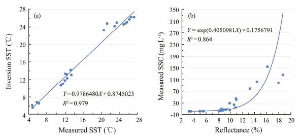
Accuracy of SST data: The measured SST data from 2010 to 2018 (Table 2) were consistent with the AVHRR data on the same day as the satellite transit (Fig.3a), with the correlation coefficient R2 = 0.979.
|
|
Table 2 Comparison of measured SST and inversion SST on the same day |
|
Fig. 3 Comparison diagram between the measured SSTs (a) and SSCs (b) and inversion results. |
Accuracy of surface suspended matter reflectance data: the surface suspended matter concentrations measured in 2006, 2010, 2011, and 2012 were well fitted with the reflectance data extracted on the same day as the satellite transit (Table 3) by a natural exponential function (R2 = 0.864) (Fig.3b).
|
|
Table 3 Simultaneously measured surface suspended matter concentration and remote sensing reflectance data |
In conclusion, the inversion data are well correlated with the measured data and could quantitatively describe the distribution of SST and suspended matter concentration in the surface seawater, with satisfying accuracies.
2.5 Key SectionThe Bohai Strait was a crucial section in this study to analyze and discuss the variation of SST and SSC. The Bohai Sea and Yellow Sea are connected by the Bohai Strait, and the signal for global climate changes is carried by the ocean circulation and transmitted to the Bohai Sea through the strait. As seen from the long-period current system distribution (Fig.1a), the Bohai Strait mainly shows the pattern of northward inflow and southward outflow. The Yellow Sea Warm Current enters the Bohai Sea in the north of the strait, and the Shandong Peninsula coastal current goes out from the south (Wei et al., 2003; Cheng et al., 2004; Shi and Wang, 2012; Zhang et al., 2018). Therefore, in the Bohai Strait, the characteristic changes of marine elements can reflect the Bohai Sea itself and its response to global climate changes.
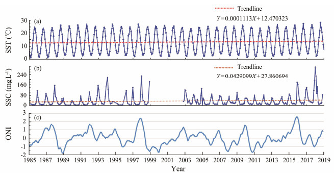
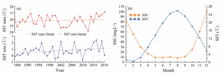
3 Results 3.1 Multi-Year Monthly Average Variations in SST and SSCFrom 1985 to 2018, the monthly average SST of the Bohai Sea were found to generally increase by 1.38℃, with an average increasing rate of 0.04℃ yr−1 (Fig.4a). The yearly average of the monthly average maximum and minimum SSTs also increased. In summer, the monthly average SST varied between 27.19℃ (August in 2018) and 24.17℃ (July in 2012), with the average value of 25.83℃, and increased about 0.35℃ in these 34 years according to the linear fitting trend. The minimum and maximum SST values in winter were −0.62℃ (February in 2010) and 2.44℃ (February in 2015), respectively, with the average value being 0.79℃. The monthly average SST in winter also increased by 0.87℃ (Fig.5a). The monthly total mean SST in these 34 years was highest in August and lowest in February (Fig.5b).
|
Fig. 4 Monthly average sea surface temperature and surface suspended matter concentration in the Bohai Sea. (a), monthly average variation of SST; (b), monthly average variation of SSC; (c), Oceanic Niño Index (ONI). |
|
Fig. 5 (a), the distribution of annual SST maximum and minimum; (b), monthly distribution of the mean SST and SSC in 34 years from 1985 to 2018. |
The monthly average SSCs from 1985 to 2018 increased by approximately 17.5 mg L−1, with an average increasing rate of 0.51 mg L−1 yr−1 (Fig.4b). The average SSC was higher in December (101.75 mg L−1) and lower in August (8.79 mg L−1) in each year. Meanwhile, the monthly mean SSC in July was the highest at about 10.6 mg L−1 during the summer (Fig.5b).
3.2 Multi-Year Variations in SST and SSC in Critical SectionsIn the past 34 years, the SST in the Bohai strait was lowest in February and highest in August, with the monthly average SST distribution showing marked seasonal differences. In winter, the SSTs in the north of the strait were high and low in the south, while the opposite distribution pattern was observed in summer (Fig.6a). The monthly average SSCs in the strait were high in the south and low in the north (Fig.6b), and this characteristic was most apparent in winter. The maximum and minimum SSC values in the strait were found in December and August. The extremum months for SST and SSC in the strait were same as those in the Bohai Sea.
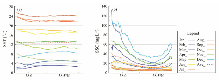
|
Fig. 6 Total monthly mean variation of SST (a) and SSC (b) in the Bohai Strait for 34 years. |
Generally, the annual maximum or minimum SSTs are more sensitive to climate changes than those in other months (Wu et al., 2004). Therefore, the monthly average SSTs in February (the lowest) in winter and August (the highest) in summer were selected for this study, and the impacts of El Niño and La Niña events on the SST in the Bohai Sea were compared and analyzed.
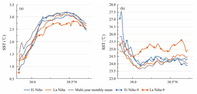
The responses of the East China Sea to El Niño and La Niña events have a delay of 6 – 9 months (Wang et al., 2020). Based on the ONI (Fig.4c) and ENSO historical schedule (Ren et al., 2018), the SSTs in February and August for the years with strong and moderate El Niño and La Niña events lasting for more than nine months were selected for comparison. In February, the monthly average SST of the strait section was higher than those in the months with El Niño and La Niña events, while the SSTs in the months with El Niño and La Niña events showed little difference (Fig.7a). In August, the monthly average SST of the strait was lower than those in the months with El Niño and La Niña events for many years, and the SSTs in the months with El Niño and La Niña events were also found to be similar (Fig.7b).
|
Fig. 7 Comparison of SSTs in February (a) and August (b) along the section across the Bohai Strait. The line marked with El Niño represents the distribution of multi-year monthly average SSTs during the El Niño events along the strait. The line marked with La Niña represents the distribution of multi-year monthly average SSTs during the La Niña events along the strait. The lines marked with El Niño-9 and La Nina-9 represent the distribution of multi-year monthly average SSTs with strong and moderate El Niño and La Niña events occurring for more than nine months along the strait. In February, the El Niño years (El Niño-9) were 1988, 1992, 1998, 2003, and 2016; the La Nina years (La Niña-9) were 1989, 2000, and 2011. In August, the El Niño years (El Niño-9) were 1987 and 2015; the La Niña years (La Niña-9) were 1999 and 2000. |
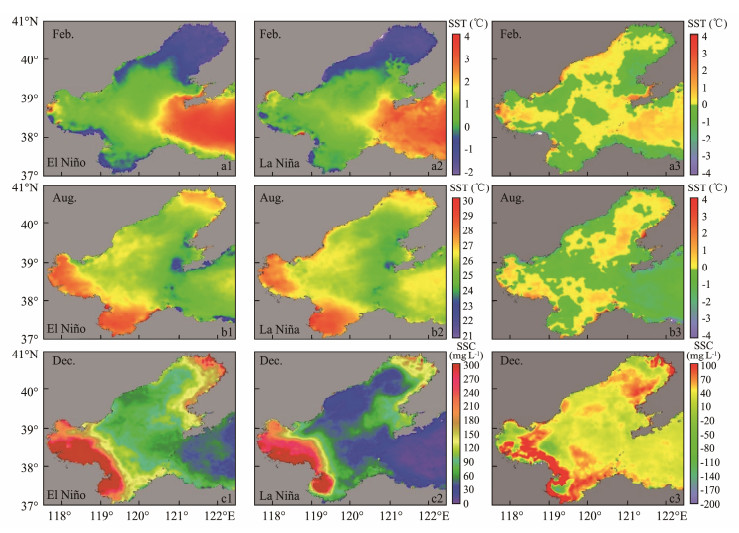
In February, the SSTs were higher in the north of the strait and lower in the south. In addition, the SSTs of El Niño months were higher than those of La Niña months in the northern part (Fig.7a). In August, the SSTs in the south of strait were higher those in the north. The SSTs in the La Niña months were higher than those in the El Niño months, except in the southern part of the strait (Fig.7b). Therefore, we inferred that the SST in the Bohai Sea presents evident differences in response to different climatic events, such as the ENSO events occurring for more than nine months, with the intensity above medium. Based on the regional average value of SSTs in the Bohai Sea, the multi-year monthly mean SSTs in February of El Niño and La Niña years were 0.92℃ and 0.9℃, respectively (Figs.8a1 and a2), compared with the regional average in all years being 0.8℃ (Fig.5b). The SST of the Bohai Sea during the El Niño event was higher than that during the La Niña event (Fig.8a3). The multi-year monthly mean SSTs in August of El Niño and La Niña years were 25.94 and 26.17℃, respectively (Figs.8b1 and b2), compared with the regional average in all years being 25.82℃ (Fig.5b). The SST of the Bohai Sea during the El Niño event was lower than that during the La Niña event (Fig.8b3). The SSTs during the ENSO events were higher than the multi-year monthly mean SSTs both in winter and summer. This phenomenon also confirmed the results of previous studies that the SST in the China Sea would increase during the ENSO events (Liu et al., 2013).
|
Fig. 8 Distribution of Multi-year monthly mean SSTs in February (a1, a2), August (b1, b2) and December (c1, c2) of the years with El Niño and La Niña events, and the differences between two events (a3, b3, c3). |
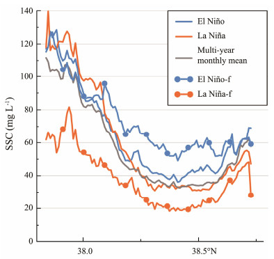
The months for the highest and lowest SSCs in the Bohai Sea were December and August. The SSC in the Bohai Sea was significantly low in summer (Fig.5b), with the average SSC in August being less than 10 mg L−1. The SSCs in December in the Bohai strait showed that in the months when El Niño and La Niña events occurred, the variation in SSCs was the same as that of the multi-year monthly average SSCs. The response of SSCs to different ENSO events was not significantly different (Fig.9), but the variation amplitude varied obviously. When the El Niño event of medium intensity or above occurred, the SSCs of the Bohai Strait in December were significantly higher than the multi-year monthly average SSCs, while the SSCs were substantially lower than the multi-year monthly average SSCs when the La Niña event of medium intensity or above occurred (Fig.9).
|
Fig. 9 Variation of multi-year monthly average SSCs along the strait in December during the years with the El Niño events (blue line) and the El Niño years (medium intensity or above, bule line with dots), in the years with La Niña events (orange line) and the La Niña years (medium intensity or above, orange line with dots), and in all study years (grey line). El Niño years (El Niño-f) are 1986, 1987, 1991, 2002, 2009, and 2015; La Niña years (La Niña-f) are 2007 and 2010. |
The distribution map of monthly average SSCs in the Bohai Sea in December (Figs.8c1 and c2) showed that the multi-year monthly average values in the whole region were 127.83 and 85.6 mg L−1 in the El Niño and La Niña months, respectively, and 101.75 mg L−1 in the total 34 years (Fig.5b). The SSC of the Bohai Sea during the El Niño events was higher than that during the La Niña events (Fig.8c3).
4 Discussion 4.1 Influencing Factors of Long-Term Variation of SST and SSC in the Bohai SeaBecause of global warming, the surface sea water absorbs a significant amount of heat, and 2018 is the warmest year in the global seawater heat record (Cheng et al., 2019).
In the past 34 years, the SST in the Bohai Sea has also increased, with an average annual increase being 0.04℃ yr−1. In 2019, National Geographic magazine reported that since the 1970s, ocean temperatures had increased rapidly from the surface to approximately 250 ft below the sea surface, increasing at a rate of 0.011℃ yr−1. We proposed that the warming rate of the Bohai Sea was four times faster than the global average. It is also proved that the Bohai Sea SST was more sensitive to global warming in some ways.
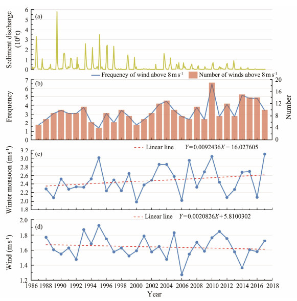
Due to global warming, the global climate has also undergone a series of changes, including the increasing frequency and magnitude of ENSO events (Cheng et al., 2019). Some studies have also shown that the weakening of the East Asian monsoon caused by global warming is the main reason for the increase in the SST of the coastal waters of China (Cai et al., 2011). The annual average wind speed in the Bohai Sea (Fig.10d) has been weakening for more than 30 years, which might be the main reason for the increase in the SST of the Bohai Sea.
|
Fig. 10 The yearly variation of the sediment discharge of Yellow River and the wind in Bohai Sea. (a) The yearly variation of the sediment discharge of Yellow River. (b) The times and frequency distribution of the wind speed greater than 8 m s−1 in the Bohai Sea. (c) Distribution of annual mean wind speed of the Bohai winter monsoon. (d) Distribution of annual average wind speed in the Bohai Sea. |
The variation in the SSC of the Bohai Sea has mainly been affected by the resuspension of sediments from the seabed and the input of sediments from the runoff (Lu et al., 2011). Water and sediment input of runoff around the Bohai Sea has significantly reduced in the past 50 years, represented by the Yellow River, which provides the most extensive water and sediment input. Under the influence of damming in the upper reaches and reduced rainfall in the basin, the annual average sediment input of the runoff has decreased from 1.3 billion tons in 1950 – 1970 to 130 million tons in 2002 – 2018, and the sediment input into the Bohai Sea was only 10% of the amount in 1986 (Fig.10a). This showed that the runoff input is not the cause of long-term SSC growth. On the other hand, the change in resuspension sediments in the Bohai Sea was also affected by wind waves. The frequency of intense wind weather in the Bohai Sea significantly increased over the past 30 years, with the gradual strengthening of the East Asian winter monsoon (Fig.10b). Thus, the SSC of the Bohai Sea increased because of enhanced wind waves. The strengthening of the East Asian winter monsoon was related to global climate changes. Global warming caused by human activities and natural factors is expected to affect the intensity and frequency of the winter monsoon. As one of the most essential biological forcing factors, the ocean can induce abnormal atmospheric circulations through air-sea interactions, especially the anomalies in sensible and latent heats, thus, causing the winter monsoon anomaly. Therefore, large-scale air-sea coupling significantly impacts the development and change of the East Asian winter monsoon. Thus, the strengthening of the East Asian winter monsoon caused by global climate changes may be the important reason behind the long-term increase in the SSC of the Bohai Sea.
In addition, the SSC of the Bohai Sea increased slightly in July every year, which was closely related to the runoff input around the Bohai Sea during summer. Based on the average monthly precipitation over 34 years, the precipitation in July was the highest, which resulted in the highest runoff input around the Bohai Sea in that month, causing a slight increase in SSC in July (Fig.5b).
4.2 Response Mechanism of SST and SSC to Climate Changes in the Bohai Sea 4.2.1 Western Pacific subtropical high and winter monsoon changesAs an inland sea of China, the Bohai Sea connected with the open ocean by the only channel, the Bohai Strait, and its SST and SSC are significantly affected by the interaction between land and sea. The Western Pacific Subtropical High (WPSH) and East Asian winter monsoon are essential factors affecting the land-sea climate, thus affecting the SST and SSC of the Bohai Sea.
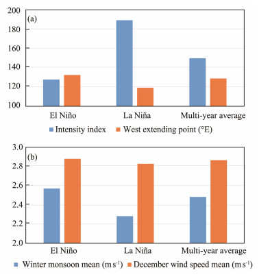
The intensity and location of WPSH change with the seasons with evident regularity (Fan and Liu, 2009). When El Niño and La Niña events occur, the position and intensity of the western Pacific subtropical high also change abnormally. In summer, when the El Niño event occurs, its position shifts eastward and the intensity weakens; when La Niña event occurs, its position shifts westward, and the intensity strengthens (Fig.11a). Therefore, the air-sea interaction under the influence of subtropical high may be an important reason for the rise of SST in Bohai Sea (Zeng et al., 2010). Also, it may be an essential reason for higher SSTs in August of the years when the La Niña event occurs than those years when the El Niño event occurs (Timmermann et al., 2018).
|
Fig. 11 (a), intensity index and the distribution of WPSH (different ENSO events during August); (b), multi-year mean wind speed in winter and in December when different ENSO events occurred. |
In winter, under the influence of the Siberian high, the winter monsoon decreases the temperature in the Northeast and North China, and also affects the SST in the Bohai Sea (Gong et al., 2002). Based on the wind speed of the Bohai Sea in winter and in December (Fig.11b), most years with the El Niño events are also the years with strong winter monsoons, and most years with the La Niña events are also the years with weak winter monsoons. Therefore, it can be inferred that in winter, the SST of the Bohai Sea will be relatively low in the years of El Niño events and relatively high in the years of La Niña events. However, this was not observed. When the ENSO event occurred, the regional average SST in the Bohai Sea was higher than the multi-year monthly average data. Moreover, the SSTs in the northern part of the Bohai Strait during the El Niño events were higher than those during the La Niña events. Thus, there must be other factors to affect the SST of the Bohai Sea.
The winter monsoon is strong during the El Niño years and weak during the La Niña years. Under the influence of the strong winter monsoon, the resuspension enhanced and the SSC increased. Therefore, the SSCs during the El Niño events were higher than those during the La Niña events (Figs.8c1, c2 and c3).
4.2.2 Variation of the Yellow Sea Warm CurrentIn winter, the strength of the Bohai Sea circulation is significantly influenced by the East Asian winter monsoon. A strong winter monsoon can reduce the SST of the Bohai Sea. However, many low-temperature coastal currents flow out of the Bohai Sea because of the strong southward winter monsoon, while the Yellow Sea Warm Current with a relatively high temperature flows into the Bohai Sea as a compensation current, which increases the SST of the Bohai Bay (Wang et al., 2012; Ma et al., 2016), especially during the El Niño events. This was also an important reason for the higher SST in the north and lower in the south along the Bohai Strait section in February of the year when the El Niño event occurred (Fig.8a1). However, during a year with weak winter monsoon, the low-temperature coastal current remains weak, which prevents the Yellow Sea Warm Current entering the Bohai Sea. This is also the reason for the continuing low SSTs in the Bohai Sea during the year with the La Niña events (Fig.8b1). This is another critical factor that affects the SST of the Bohai Sea.
4.3 Linkage Responses of SST and SSC to Climate ChangesWhen a climate anomaly event begin, the SST will first respond through the atmosphere and ocean circulation, and transmit the temperature signals rapidly (Timmermann et al., 2018). In general, when the El Niño event occurs, the SST of the western Pacific Ocean decreases and the anomaly signal is transmitted to the Bohai Sea through Kuroshio and Yellow Sea Warm Current, thus, decreasing the SST of the Bohai Sea. Kuroshio is a high temperature water body that flows northward across the East China Sea and is an important branch of the Western Pacific Warm Pool. The north branch of Kuroshio, which is stronger in the winter half year and weaker in the summer half year, can reach the Yellow Sea along the Yellow Sea trough, and then help complete the water exchange with the Bohai Sea through the Bohai Strait (Liu et al., 2016).
When the La Niña event occurs, the SST of the western Pacific Ocean increases and is transmitted to the Bohai Sea through Kuroshio and Yellow Sea Warm Current, thus, increasing the SST of the Bohai Bay. However, the Bohai Sea is an inland sea, embedded in the interior of continent, and markedly affected by the local climate (Li et al., 2014). The monsoon and circulation changes caused by climatic events diversify the responses of SST in the Bohai Sea to the ENSO events. The shift in monsoon and circulation caused by the changes of SST further modifies the ocean dynamic features, resulting in strong winds, waves and currents, thus, changing the SSC (Bao et al., 2002; Jiang et al., 2002). Therefore, the SST and SSC can respond to global climate changes with the help of the monsoon and circulation.
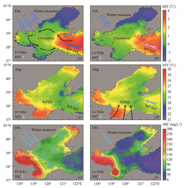
In winter, when the El Niño event occurred, the SST in the western Pacific was low. Still, the winter monsoon under the action of Siberian high was stronger than those in previous years, which subsequently strengthened the circulation in the Bohai Sea. Many warm water masses from the Yellow Sea entered the Bohai Sea from the northern part of the Bohai Strait, thus increasing the SST in the Bohai Sea (Ma et al., 2016). When the La Niña event occurred, the SST in the western Pacific was higher, but the winter monsoon in this year was weaker than those of previous years, which also weakened the circulation in the Bohai Sea. Thus, the SST of the Bohai Sea was less affected by the Yellow Sea warm water mass compared with previous years (Figs.8a1 and a2).
In summer, when a La Niña event occurred, the Western Pacific SST was higher, and the WPSH was stronger than those of previous years, which increased the SST of the Bohai Sea. When an El Niño event occurred, the phenomenon is the opposite (Figs.10 and 12). In addition, the SSC of the Bohai Sea was significantly affected by the intensity of the winter monsoon. In the El Niño year, the winter monsoon was stronger than those in previous years, and the SSC of the Bohai Sea was larger than those in previous years. In the La Niña year, the winter monsoon was weaker than those in the previous years, and the SSC of the Bohai Sea was lower than those in the previous years (Figs.10 and 12).
|
Fig. 12 Coupled SST and SSC responses to ENSO events occurred in February (a, b), August (c, d), and December (e, f) in the Bohai Sea. |
From 1985 to 2018, the SSTs of the Bohai Sea increased by 1.38℃, with an average rate of 0.04℃ yr−1, which was faster than the global average sea surface temperature. The SSC increased by approximately 17.5 mg L−1, with an average rate of 0.51 mg L−1 yr−1, which may be related to the strengthening of the Bohai Sea winter monsoon and the increasing frequency of gale weather in recent years. In addition, the increase in SSC in July was closely related to the precipitation in that month.
Seasonal differences were observed in responses of SST and SSC to the ENSO events in the Bohai Sea. During the El Niño years, the SST is higher than that of La Niña years in the winter, but this phenomenon is opposite in the summer. The SSC of the Bohai Sea in winter was higher when El Niño occurred, and this was related to the monsoon intensity caused by the ENSO event. Therefore, the SST and SSC of the Bohai Sea during the El Niño events in winter were higher than those during the La Niña events.
When the ENSO events occurred, the East Asian winter monsoon, Western Pacific Subtropical High and Yellow Sea Warm Current changed correspondingly, which were the direct factors affecting the SST and SSC of the Bohai Sea. When an ENSO event occurred in winter, the strength of the circulation was the key factor determining the SST and SSC of the Bohai Sea. During the summer, the position and strength of the western Pacific subtropical high were the important factors affecting the SST of the Bohai Sea.
AcknowledgementsThis research was supported by the National Natural Science Foundation of China (No. 42121005), and the Taishan Scholars Program of Shandong Province (to G. X. Li).
Bao, B., and Ren, G., 2014. Climatological characteristics and long-term change of SST over the marginal seas of China. Continental Shelf Research, 77: 96-106. DOI:10.1016/j.csr.2014.01.013 (  0) 0) |
Bao, X. W., Wan, X. Q., Gao, G. P., and Wu, D. X., 2002. The characteristics of the seasonal variability of the sea surface temperature field in the Bohai Sea, the Huanghai Sea and the East China Sea from AVHRR data. Acta Oceanologica Sinica, 24(5): 125-133 (in Chinese with English abstract). (  0) 0) |
Bi, N. S., Yang, Z. S., Wang, H. J., Fan, D. J., Sun, X. X., and Lei, K., 2011. Seasonal variation of suspended-sediment transport through the southern Bohai Strait. Estuarine, Coastal and Shelf Science, 93(3): 239-247. DOI:10.1016/j.ecss.2011.03.007 (  0) 0) |
Brest, C. L., and Rossow, W. B., 1992. Radiometric calibration and monitoring of NOAA AVHRR data for ISCCP. International Journal of Remote Sensing, 13(2): 235-273. DOI:10.1080/01431169208904037 (  0) 0) |
Cai, R. S., Chen, J. L., and Tan, H. J., 2011. Variations of the sea surface temperature in the offshore area of China and their relationship with the East Asian monsoon under the global warming. Climatic and Environmental Research, 16(1): 5549-5551. (  0) 0) |
Che, N., and Price, J. C., 1992. Survey of radiometric calibration results and methods for visible and near infrared channels of NOAA-7, -9, and -11 AVHRRs. Remote Sensing of Environment, 41: 19-27. DOI:10.1016/0034-4257(92)90057-Q (  0) 0) |
Chen, P. Y., Srinivasan, R., Fedosejevs, G., and Narasimhan, B., 2002. An automated cloud detection method for daily NOAA-14 AVHRR data for Texas, USA. International Journal of Remote Sensing, 23(15): 2939-2950. DOI:10.1080/01431160110075631 (  0) 0) |
Cheng, L. J., Zhu, J., Abraham, J., Trenberth, K. E., Fasullo, J. T., Zhang, B., et al., 2019. 2018 continues record global ocean warming. Advances in Atmospheric Sciences, 36(3): 249-252. DOI:10.1007/s00376-019-8276-x (  0) 0) |
Cheng, P., Gao, S., and Bokuniewicz, H., 2004. Net sediment transport patterns over the Bohai Strait based on grain size trend analysis. Estuarine, Coastal and Shelf Science, 60(2): 203-212. DOI:10.1016/j.ecss.2003.12.009 (  0) 0) |
Fan, L., and Liu, Q. Y., 2009. Relationship between the western Pacific subtropical high and sea-surface temperature anomaly. Journal of Tropical Oceanography, 28(5): 83-88 (in Chinese with English abstract). (  0) 0) |
Fang, Y., Fang, G. H., and Zhang, Q. H., 2000. Numerical simulation and dynamic study of the wintertime circulation of the Bohai Sea. Chinese Journal of Oceanology and Limnology, 18(1): 1-9. DOI:10.1007/BF02842535 (  0) 0) |
Fell, F., Preusker, R., Fischer, J., and Schroder, T., 2001. Automated atmospheric correction of AVHRR channel 1 and 2 data using dark surface targets. IEEE International Symposium on Geoscience and Remote Sensing (IGARSS). Sydney: 2707-2711. (  0) 0) |
Gong, D. Y., Zhu, J. H., and Wang, S. W., 2002. The influence of Siberian high on large-scale climate over the continental Asian. Plateau Meteorology, 21(1): 8-14 (in Chinese with English abstract). (  0) 0) |
Han, X., Cai, Y., Chen, X. R., and Li, Y., 2014. Analysis of temporal and spatial distribution characteristics of winter SST anomalies in the Bohai Sea and Yellow Sea and their influencing factors. Journal of Tropical Oceanography, 33(5): 1-12 (in Chinese with English abstract). (  0) 0) |
Huang, D., Su, J., and Backhaus, J. O., 1999. Modelling the seasonal thermal stratification and baroclinic circulation in the Bohai Sea. Continental Shelf Research, 19(11): 1485-1505. DOI:10.1016/S0278-4343(99)00026-6 (  0) 0) |
Jiang, W. S., Su, J., Yang, H., Zhang, Y. J., Jiang, H., Wang, Q. Y., et al., 2002. The relationship between SPM concentration and hydrodynamic condition in the Bohai Sea. Acta Oceanologica Sinica, 24(S1): 212-217 (in Chinese with English abstract). (  0) 0) |
Kilpatrick, K. A., Podestá, G. P., and Evans, R., 2001. Overview of the NOAA/NASA advanced very high resolution radiometer pathfinder algorithm for sea surface temperature and associated matchup database. Journal of Geophysical Research, 106(C5): 9179-9197. DOI:10.1029/1999JC000065 (  0) 0) |
Li, G. X., Li, P., Liu, Y., Qiao, L. L., Ma, Y. Y., Xu, J. S., et al., 2014. Sedimentary system response to the global sea level change in the East China Seas since the last glacial maximum. Earth-Science Reviews, 139: 390-405. DOI:10.1016/j.earscirev.2014.09.007 (  0) 0) |
Li, S. H., and Yun, C. X., 2001. A study on quantitative model of the suspended sediment concentration from the meteorological satellite imagery. Journal of Remote Sensing, 5(2): 154-160. (  0) 0) |
Liu, N., Wang, H., Ling, T. J., and Feng, L. C., 2013. The influence of ENSO on sea surface temperature variations in the China seas. Acta Oceanologica Sinica, 32: 21-29. (  0) 0) |
Liu, X., Li, G. X., Ma, Y. Y., Ding, D., Dada, O. A., Xu, J. S., et al., 2016. Distribution and diffusion of surface suspended matter off the East China shore, 2010. Geological Journal, 51: 49-59. DOI:10.1002/gj.2814 (  0) 0) |
Lu, J., Qiao, F. L., Wang, X. H., Wang, Y. G., Teng, Y., and Xia, C. S., 2011. A numerical study of transport dynamics and seasonal variability of the Yellow River sediment in the Bohai and Yellow Seas. Estuarine, Coastal and Shelf Science, 95(1): 39-51. DOI:10.1016/j.ecss.2011.08.001 (  0) 0) |
Lyu, W. Z., Yang, J. C., Fu, T. F., Chen, Y. P., Hu, Z. X., Tang, Y. Z., et al., 2020. Asian monsoon and oceanic circulation paced sedimentary evolution over the past 1, 500 years in the central mud area of the Bohai sea. China. Geological Journal, 55(7): 5606-5618. DOI:10.1002/gj.3758 (  0) 0) |
Ma, W. W., Wan, X. Q., and Wan, K., 2016. Interannual variation characteristics and mechanism analysis of wind-driven circulation in Bohai Sea in winter. Ocean and Limnology, 47(2): 8. (  0) 0) |
Ren, H. L., Lu, B., Wan, J., Tian, B., and Zhang, P., 2018. Identification standard for ENSO events and its application to climate monitoring and prediction in China. Journal of Meteorological Research, 32(6): 923-936. DOI:10.1007/s13351-018-8078-6 (  0) 0) |
Shi, W., and Wang, M., 2012. Satellite views of the Bohai Sea, Yellow Sea, and East China Sea. Progress in Oceanography, 104: 30-45. DOI:10.1016/j.pocean.2012.05.001 (  0) 0) |
Su, L. H., and Gibeaut, J. C., 2013. An inter-sensor calibration and atmospheric correction system for long-term time series of AVHRR imagery for coastal waters. GIScience & Remote Sensing, 50(2): 184-195. (  0) 0) |
Timmermann, A., An, S. I., Kug, J. S., Jin, F. F., Cai, W. J., Capotondi, A., et al., 2018. El Niño-southern oscillation complexity. Nature, 559(7715): 535-545. DOI:10.1038/s41586-018-0252-6 (  0) 0) |
Wang, M., Guo, J. R., Song, J., Fu, Y. Z., Sui, W. Y., Li, Y. Q., et al., 2020. The correlation between ENSO events and sea surface temperature anomaly in the Bohai Sea and Yellow Sea. Regional Studies in Marine Science, 35: 101228. DOI:10.1016/j.rsma.2020.101228 (  0) 0) |
Wang, Q., Li, Y., Li, Q., Liu, Y., Wang, Y. N., 2019. Changes in means and extreme events of sea surface temperature in the East China Seas based on satellite data from 1982 to 2017. Atmosphere, 10: 140. DOI:10.3390/atmos10030140 (  0) 0) |
Wang, Z. Z., Zuo, J. C., Chen, M. X., Xu, Q., and Yang, Y., 2012. Relationship between El Niño and sea surface temperature variation in coastal region of Yellow Sea and East China Sea. Journal of Hohai University (Natural Science Edition), 40(4): 461-468 (in Chinese with English abstract). (  0) 0) |
Wei, Z. X., Li, C. Y., Fang, G. H., and Wang, X. Y., 2003. Numerical diagnostic study of the summertime circulation in the Bohai Sea and the water transport in the Bohai Strait. Advances in Marine Science, 21(4): 454-464 (in Chinese with English abstract). (  0) 0) |
Wentz, F. J., Scott, J., Hoffman, R., Leidner, M., Atlas, R., and Ardizzone, J., 2015. Remote Sensing Systems Cross-Calibrated Multi-Platform (CCMP) 6-hourly ocean vector wind analysis product on 0.25 deg grid, Version 2.0.
(  0) 0) |
Wu, D. X., Wan, X. Q., Bao, X. W., Mu, L., and Lan, J., 2004. Comparison of summer thermohaline field and circulation structure of the Bohai Sea between 1958 and 2000. Chinese Science Bulletin, 49(4): 363-369. DOI:10.1007/BF02900319 (  0) 0) |
Xie, S. P., Hafner, J., Tanimoto, Y., Liu, W. T., Tokinaga, H., and Xu, H. M., 2002. Bathymetric effect on the winter sea surface temperature and climate of the Yellow and East China Seas. Geophysical Research Letters, 29(24): 2228. (  0) 0) |
Yang, Y., Yang, J. K., Miao, Q. S., and Gao, X. M., 2017. The interannual trend and preliminary quantitative estimation of the oceans condition in the Bohai Sea area. IODP Conference Series Earth and Environmental Science, 52: 012061. DOI:10.1088/1742-6596/52/1/012061 (  0) 0) |
Yang, Z., Ji, Y., Bi, N., Lei, K., and Wang, H., 2011. Sediment transport off the Huanghe (Yellow River) delta and in the adjacent Bohai Sea in winter and seasonal comparison. Estuarine, Coastal and Shelf Science, 93(3): 173-181. DOI:10.1016/j.ecss.2010.06.005 (  0) 0) |
Zeng, G., Sun, Z. B., Lin, Z. H., and Ni, D. H., 2010. Numerical simulation of impacts of sea surface temperature anomaly upon the interdecadal variation in the northwestern Pacific subtropical high. Atmospheric Science, 34(2): 307-322 (in Chinese with English abstract). (  0) 0) |
Zhang, Z. X., Qiao, F. L., Guo, J. S., and Guo, B. H., 2018. Seasonal changes and driving forces of inflow and outflow through the Bohai Strait. Continental Shelf Research, 154: 1-8. DOI:10.1016/j.csr.2017.12.012 (  0) 0) |
Zhou, Z., Bian, C. W., Wang, C. H., Jiang, W. S., and Bi, R., 2016. Quantitative assessment on multiple timescale features and dynamics of sea surface suspended sediment concentration using remote sensing data. Journal of Geophysical Research: Oceans, 122(11): 8739-8752. (  0) 0) |
 2023, Vol. 22


