Mangroves are a group of highly adapted halophytes occupying the intertidal zone in estuaries, lagoons, and coastal mudflats attropical and subtropical latitudes. Mangroves protect coastal environments from erosion and provide ecological and socioeconomic values to humans and the environment (Alongi 2009). Mangroves create a buffer zone, which mitigates coastal erosion by producing leaf litter and detritus which provides a food source for marine organisms and enhances fisheries (Tse et al. 2008). Mangroves also enhance and sustain the natural biomass of coral reef fish and aquaculture products (Mumby et al. 2004; Naylor et al. 2000). Mangroves enhance water quality by trapping nutrients and heavy metals. Products from mangroves also have commercial value that benefits local people by providing a source of income. Mangroves have long been used as construction materials (pile wood), charcoal, pulp source, firewood, tannin, and traditional medicine products used by villagers. The diversity of flora and fauna associated with mangrove ecosystems provides opportunities for nature education, tourism and scientific studies (Aston et al. 2002). The greatest biodiversity occurs in the mangals of New Guinea, Indonesia, and Malaysia (Saenger 2002; Peter 2007).
Despite its importance, the mangrove ecosystem is threatened with destruction through various forms of human pressure (Farnsworth et al. 1997; FAO 2007). Degradation from coastal development and overexploitation are the major threats to mangroves (Gang et al. 1992; Perez Osuna 2000). Destruction of mangrove forests by human activities has degraded species richness at many locations (Spalding et al. 1997).
Such problems are apparent along the Kilim River, Langkawi Island. Langkawi is one of the main tourist islands in Malaysia and the pace of development has degraded the mangrove ecosystem over a decade. Designation of Langkawi as a Geo-Park by The United Nations Educational, Scientific and Cultural Organization (UNESCO) boosted the tourism industry and led to development on the island, particularly in the coastal zone.
To ensure mangrove survival and sustainable coastal zone development, it is essential to monitor mangrove cover for changes in area over time. Accurate, cost-effective, and comprehensive methods of monitoring mangrove ecosystems have led to development of better mangrove management plans. Remote sensing and Geographic Information System (GIS) technologies are used widely in mangrove monitoring and mapping. Use of remote sensing tools enables discrimination of mangroves from other vegetation types, and leads to reliable mapping (Green et al. 1998). Additional information of geography and environmentally sensitive zones from GIS data also can improve mapping results.
Based on the importance of the mangrove ecosystem in the coastal zone, in this study we investigated the role of coastal developmental activities in the degradation of the mangrove cover along the Kilim River, Langkawi Island, Malaysia.
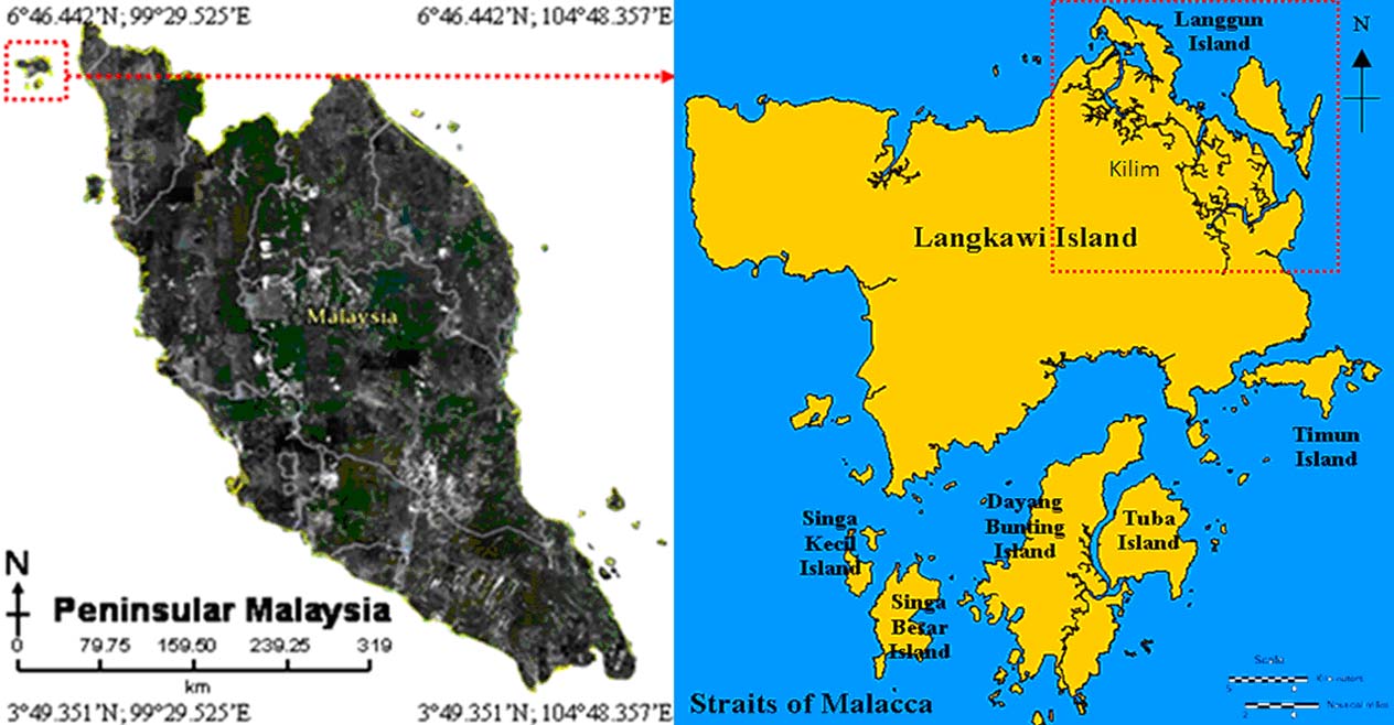
Materials and methods Study siteKilim River is located in the northeast part of the Langkawi Island, west coast of peninsular Malaysia (Fig. 1). Kilim River (6°21.518′-6°26.093′ N and 99°49.091′-99°55.159′ E) has a semi-diurnal tide and average temperature of 25℃ to 37℃. Mean monthly rainfall ranges from 151.9-263.9 mm. Mean daily temperatures ranged from 26.6-29.3℃ during 2003–2008 (Data obtained from Langkawi Meteorology Department).

|
Fig. 1 Location of the study areahat Kilim River, Langkawi Island |
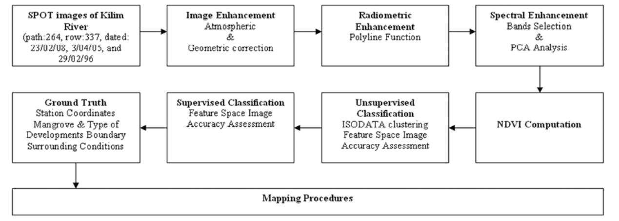
SPOT images were processed according to standard methods (Green et al. 1998) to produce supervised images of mangrove and coastal developments (Fig. 2). SPOT images of Langkawi Island (path: 264, row: 337, dated: 23/02/08, 3/04/05, and 29/02/96, ) provided by Malaysian Remote Sensing Agency (MACRES) were used to classify the mangrove and coastal development in Kilim River. The images were later fine-tuned to enhance important features of raw, remotely sensed data and aerial photographs. Enhancement techniques were often used instead of classification for extracting useful information from images. Differences or anomalies were corrected using mathematical formulas derived from the distortion, which included radiometric and geometric corrections (Lillesand et al. 2004).

|
Fig. 2 Flowchart of the descriptive steps involved in Image Processing |
Atmospheric anomalies in the images were corrected using linear regression and geometric corrections were rectified to a particular map projection and pixel size. Series of independent, single-band enhancements were applied through radiometric enhancements (Faust 1989).
Principal Component Analysis (PCA) was used in data compression. Redundant data were compacted, and displayed new bands that are more interpretable to the eye through mathematical transformations and algorithms. Normal distributions of the bands were interpreted in ellipse shapes. Normalized Difference Vegetation Index (NDVI) was used to strengthen the difference between water bodies, land, urban areas, and vegetation. It is based on computation of similar pixel values and spectral signatures into the same group.
| $ {N_{{\rm{DVI}}}} = \left({{N_{{\rm{IR}}}} - {R_{{\rm{ED}}}}/{N_{{\rm{IR}}}} + {R_{{\rm{ED}}}}} \right) $ |
where, NIR = near infrared; RED = red band. Unsupervised classifications were conducted using Iterative Self-Organizing Data Analysis Technique (ISODATA) clustering. Pixels that satisfied certain sets of mangrove vegetation and coastal developments were assigned to the class that corresponded to those pixel criteria. With data from ground-truthing, we conducted supervised classification. This led to production of a mangrove and coastal development map in ArcView 3.3 software.
From the feature space of supervised classification (Fig. 3), the spectral image for the year 2008 was slightly overlapped. The accuracy for 2008 supervised classification image was 98.83% with Kappa (

|
Fig. 3 Feature space of supervised images. Different colours shows concentration of each ellipse represented supervised groups |
Several reference pixels were pointed on the classified image and actual data were selected randomly (Congalton 1991). Using the unsupervised image, several ground truth stations were selected at each classified group. In total, 31 stations were stated as reference points on the map. The reference points were used to calculate the exact error between true coordinates on the ground and the marked coordinates (Green et al. 1998). The coordinates of each station were generated from coordinate calculation and marked using bamboo during field observation. The dominant species and tree density at each station were estimated and recorded. Composition of mangrove species was estimated visually (Green et al. 1998; Vaiphasa et al. 2005).
Results and discussion Types of coastal developments in Kilim RiverMangroves along the Kilim River coastal area were converted to agriculture, mariculture/aquaculture ponds, and commercial and residential areas. Large portions of mangroves were cleared for jetty construction which led to increased boat traffic in Kilim mangroves and along the river. In the northern part of the basin, some mangroves were converted by villagers into farmlands. Most of the mangroves were cleared after 1996 and some of deforested areas were converted into residential areas. The southern part of Kilim River was less populated, and the deforested portion was left without any further development. Several aquaculture pond areas expanded after 1996. Although the occupied areas were relatively small, the number of ponds increased over the recent 20 years. Resorts and commercial lots were developed near the sandy beaches in the cleared mangrove areas.
Paddy fields expanded into the area of coastal zone landward of the mangroves and this also caused degradation of mangroves in certain areas. The suitability of the area for agriculture probably encouraged the villagers to expand paddy fields into the back mangrove areas.
Mangrove destruction for commercial/residential areaLangkawi is one of the most beautiful islands in Malaysia and has attracted development of many resorts and hotels in the coastal zone to satisfy the tourism market. Villagers also prefer the coastal areas and riverbanks for their aesthetic values. These trends have resulted in clearing of mangroves, especially at the seaward side of mangrove stands. Because the seaward mangroves serve to reduce the wave action, removal of these trees results in coastal erosion (Spalding et al. 1997).
Mangrove cleared for timberSince most of the mangrove forests in Kilim River were not gazette as Permanent Forest areas, deforestation has been undertaken by local communities to provide timber for private use in construction of small jetties or other structures. However, this type of exploitation has been monitored by the Forestry Department especially after the island was gazette as a Geopark in 2007.
Jetty construction and wake current actionThe important role of water transportation throughout Langkawi has led to increased numbers of jetties being constructed in mangrove areas. Mangroves are permanently lost at jetty locations. Development of these jetties was required to enhance water transportation and efficiency of the fishing industry. The increase in boat numbers caused increased frequency and intensity of wake currents that slowly erode the banks and degrade mangroves. Affected mangroves are typically those farthest seaward but erosion extended landward to the middle mangrove area.
Mangrove conversion for Aquaculture & MaricultureCulture of crustaceans is the primary aquaculture activity along the Kilim River banks. Mangals were considered highly suitable for shrimp farming because the areas were flooded with brackish and stagnant water that is ideal for aquaculture. Increasing tourist demand for seafood have led to increased production of aquaculture products. With high cost for management of the Because well designed aquaculture systems are expensive, many developers dug small-scale ponds and relied on intensive but untreated systems. This led to rapid degradation and loss of mangroves. Although several ponds were properly managed, substantial areas of mangrove were degraded at aquaculture sites due to site preparation and drainage damage.
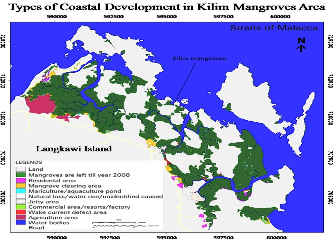
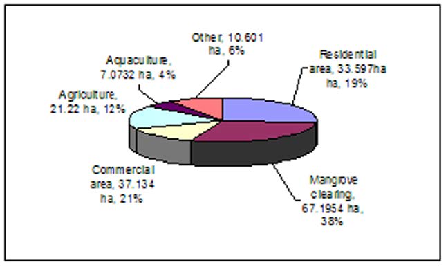
Mangrove degradation in Kilim RiverThe Kilim mangroves occupied about 48% or 1976.24 ha of total mangrove area on Langkawi Island in 2008. This was after loss of about 8% (176.83 ha) of total mangrove cover over the period of 14 years since 1996. The extent of mangrove deforestation due to costal development during the recent 14 years is shown in Fig. 4. The percentage of mangrove degradation caused by various coastal developmental activities along the Kilim River is illustrated in Fig. 5.

|
Fig. 4 Types of coastal development along the Kilim River, Langkawi |

|
Fig. 5 Percentage of mangrove degradation caused by coastal development |
Mangrove provides ideal natural habitat for intertidal organisms. For this reason it has been among the most exploited ecosystems for aquaculture. Coastal shrimp and fish-pond aquaculture conflicted with mangrove conservation in this area because coastal ponds were constructed on drained mangrove sites. Polluted waters from aquaculture increase the potential for disease outbreaks, especially among mangrove seedlings. This reduces the dispersion of mangrove droppers thereby impacts the natural re-planting process. The increasing numbers of fishing villages in the mangrove area along the Kilim River exert pressure to clear additional mangals for house construction. Consequently, unmonitored settlements in the coastal zone directly reduce mangrove cover. Increasing usage of boats and fishing vessels along the jetties built near the coast induced wake currents, which slowly eroded riverbanks and coasts. Heavy traffic due to high demand for boat tours combined with the daily routines of fishing vessels will eventually increase erosion along the Kilim River.
In the northern part of Langkawi Island, transitional dryland forests found between stands of mangroves and true dryland forest faced threat due to land conversion for agriculture. Paddy farming was the base agriculture practice on the island and it requires large fields. Hotels, resorts, and chalets were built near the coastal area to meet tourism demands. All of these developments degraded mangroves, particularly affecting the seaward mangrove species. This led to coastal erosion.
Most of the mangrove degradation on Langkawi Island occurred in Forest Reserves. Yet, some of these losses occurred in Permanent Forest Reserves because the monitoring program throughout the islands is inadequate. Local authorities need expertise to deal with large mangrove areas to ensure mangrove sustainability in the face of development pressures.
ConclusionsMangrove forests in Kilim river have decreased over time due to several types of coastal development. This has directly and indirectly affected the mangrove cover despite the recognition of the importance of ecological and economic services provided by mangroves. Aquaculture/mariculture practice in Kilim River need to be monitored and supervised to ensure that farmers practice proper culture methods and management. Proper management through sustainable aquaculture and mangrove conservation has generated incomes and food supplies for local communities and the entire country. For example, the total production of aquaculture ponds around Matang Mangroves, Perak, was estimated at 431 tonnes with a market value of RM 13.3 million (Azahar et al. 2009).
Mangrove conversion for settlement and commercial areas, agriculture and forestation is inevitable in Kilim River. However, the losses of mangrove due to these factors can be replaced through continuous efforts of conservation and restoration. Such programs have proven successful at other locations at balancing ecological importance with socioeconomic values of mangrove forests (Azahar et al. 2009; Imhoff et al. 1987; Imhoff et al. 1990; Blasco et al. 1994).
Remote sensing is a useful technology for monitoring and mapping large areas of mangrove forest (Jensen et al. 1991; Ramsey et al. 1996; Gang et al. 1992; Brakel 1984; Silapathong 1992; Klemas et al. 1975, and Terchunian et al. 1986). However, due to the limitations of sensors, additional information on spectral reflectance for each mangrove genus is essential. The use of hyperspectral data is an alternative for better mangroves mapping.
Mangrove cover in Kilim River, Langkawi declined by approximately 8.2% since 1996. This was caused by mangrove clearing (38%), commercial development (21%), residential development (19%), agriculture (12%), others (6%) and aquaculture (4%). Use of mangroves is necessary for the benefit of people and country. Yet it needs good planning to prevent mangrove losses and maintain the ecosystem balance.
AcknowledgementThe authors would like to express special gratitude to Malaysian Remote Sensing Agency (MACRES) for providing materials (SPOT images) used in this research.
Alongi DM (2009) The Energetic of Mangrove Forest. 1st Ed.. New York: Springer: pp. 1-125.
|
Aston EC, Macintosh DJ (2002) Preliminary assessment of the plant diversity and community ecology of the Sematan mangrove forest, Sarawak, Malaysia. Forest Ecology and Management 166: 111-129. DOI:10.1016/S0378-1127(01)00673-9 |
Azahar M, Nik MS (2009) A Working Plan for the Matang Mangrove Forest Reserved, Perak. 5th Ed. Perak: State Forestry Department Publication.
|
Blasco F, Janodet E, Bellan MF (1994) Impacts of coastal hazards on mangroves in the Bay of Bengal. Journal of Coastal Research 12: 277-88. |
Brakel WH (1984) Seasonal dynamics of the suspended sediment plumes from Tano and Sabaki Rivers, Kenya: analysis of coastal imagery. Remote Sensing of Environment 18: 165-173. |
Congalton RG (1991) A review of Assessing the Accuracy of Classification of Remotely Sensed Data. Remote Sensing Environment 37: 35-46. DOI:10.1016/0034-4257(91)90048-B |
FAO (2007) The World's Mangroves 1980-2005. Rome: FAO: pp. 21-27.
|
Farnsworth EJ, Ellison AM (1997) The global conservation status of mangroves. Ambio 26: 328-334. |
Faust NL (1989) Image enhancement in Encyclopedia of Computer Science and Technology. Vol. 20. New York: Marcel Dekker Inc.
|
Gang PO, Agatsiva JL (1992) The current status of mangroves along the Ken yan coast: a case study of Mida Creek mangroves based on remote sensing. Hydrobiologia 247: 29-36. DOI:10.1007/BF00008202 |
Green EP, Clark CD, Mumby PJ, Edwards AJ, Ellis AC (1998) Remote sensing techniques for mangrove mapping. International Journal of Remote Sensing 19(5): 935-956. DOI:10.1080/014311698215801 |
Imhoff ML, Gesch DB (1990) The derivation of a sub-canopy digital terrain model of a flooded forest using synthetic aperture radar. Photogrammetric Engineering and Remote Sensing 56(8): 1155-62. |
Imhoff ML, Vermillion C, Story MH (1987) Monsoon flood boundary delineation and damage assessment using space borne imaging radar and Landsat data. Photogrammetric Engineering and Remote Sensing 53(4): 405-413. |
Jensen JR, Lin H, Yang XH, Ramsey EW (1991) The measurement of mangrove characteristics of southwest Florida using SPOT multispectral data. Geocarto International 2: 13-21. |
Klemas V, Bartlett DS (1975) Coastal zone classification from satellite imagery. Photogrammetric Engineering and Remote Sensing 41(4): 499-513. |
Lillesand TM, Kiefer RW, Chipman JW (2004) Remote Sensing and Image Interpretation. New York: John Wiley and Sons Inc.: p. 763.
|
Mumby PJ, Edwards AJ, Arias-Gonzalez E, Lindeman KC, Blackwell PG, Gall A, Gorzynska MI, Harborne AR, Pescod CL, Renken H, Wabnitz CCC, Llewellyn G (2004) Mangroves enhance the biomass of coral reef fish communities in the Carribean. Nature 427: 533-536. DOI:10.1038/nature02286 |
Naylor RL, Goldburg RJ, Primavera JH, Kautsky N, Beveridge MCM, Clay J, Folke C, Lubchencho J, Mooney H, Troell M (2000) Effect of aquaculture on world fish supplies. Nature 405: 1017-1024. DOI:10.1038/35016500 |
Perez Osuna F (2000) The environmental impact of shrimp aquaculture: a global perspective. Environmental Pollution 112: 1-3. |
Peter JH (2007) The Biology of Mangroves and Seagrasses. 2nd Ed.. New York: Oxford University Press: pp. 183-202.
|
Ramsey EW, Jensen JR (1996) Remote sensing of mangrove wetlands: relating canopy spectra to site-specific data. Photogrammetric Engineering and Remote Sensing 62(8): 939-48. |
Saenger P (2002) Mangrove Ecology, Silviculture, and Conservation. Dordrecht: Kluwer Academic Publisher: pp. 243-265.
|
Silapathong CH, Blasco F (1992) The application of geographic information systems to mangrove forest management: Khlung, Thailand. Asian Pacific Remote Sensing Journal 5(1): 97-104. |
Spalding M, Blasco F, Field C (1997) World Mangrove Atlas. Okinawa: International Society for Mangrove Ecosystems (ISME): p. 31.
|
Terchunian A, Klemas V, Asegovia M (1986) Mangrove mapping in Ecuador: the impact of shrimp pond construction. Environmental Management 10(3): 345-50. DOI:10.1007/BF01867258 |
Tse P, Nip THM, Wong CK (2008) Nursery function of mangrove: A comparison with mudflats in terms of fish species composition and fish diet. Estuarine, Coastal and Shelf Science 80: 235-242. DOI:10.1016/j.ecss.2008.08.002 |
Vaiphasa C, Ongsomwang S, Vaiphasa T, Skidmore AK (2005) Tropical mangroves species discrimination using hyperspectral data: a laboratory study. Estuarine, Coastal and Shelf Science 65: 371-379. DOI:10.1016/j.ecss.2005.06.014 |
 2012, Vol. 23
