 2017, Vol. 60

 , DANG Ya-Min1
 , ZHANG Chuan-Yin1, BAO Li-Feng2, LIANG Shi-Ming3, HE Zhi-Tang4, ZOU Zheng-Bo5
2 Institute of Geodesy and Geophysics, Chinese Academy of Sciences, Wuhan 430077, China;
3 Institute of Geology, China Earthquake Administration, Beijing 100029, China;
4 The First Geodetic Brigade, National Administration of Surveying, Mapping and Geoinformation, Xi'an 710054, China;
5 Institute of Earthquake, China Earthquake Administration, Wuhan 430071, China
The changes of Earth's surface loads, including seawater, atmospheric and terrestrial water, etc. and the adjustments of the solid earth caused by them have impacts on crustal deformation and gravity changes (Farrell, 1972; Blewitt et al., 2003). On the seasonal and interannual scales, mass redistribution is mainly derived from the water cycle (Blewitt et al., 2001). The study of the spatial and temporal changes of water storage at different scales has important significance to the understanding of the regional water cycle, on climate change research and on the prevention and control of floods and droughts. However, depending on the soil water, groundwater and other elements at the ground observation stations, it is difficult to observe each component of the terrestrial water storage effectively, especially the groundwater storage, which increases the difficulty of calculating the influence of regional land water load.
Based on the data from the GRACE satellite gravity measurements, we can effectively get a large-range mass load change sequence or gravity field variations due to terrestrial water migration (Wahr et al., 1998; Tapley et al., 2004; Zhou et al., 2006). Using the relationship between the surface load change and the elastic deformation theory, the deformation caused by water migration could be derived (Farrell, 1972; Van Dam et al., 2001). However, due to the smoothing signal, GRACE observes monthly global mass redistributions at spatial scales of 300 km and above. Using GNSS (Global Navigation Satellite System) measurements as high accuracy observations of the crustal deformation, and through the continuous observations of the changes in site coordinates, it is possible to effectively reflect the crustal deformation caused by the water transport (Dong et al., 2002; Kusche et al., 2005; Tesmer et al., 2011; Argus et al., 2014; Wang et al., 2014; Fu et al., 2015), and this has a better spatial resolution than GRACE. Using GNSS to calculate the effect of the terrestrial water load, the result is affected by GNSS system error, noise, and unstable factors in inversion. Consequently, the calculation method and the calculation accuracy need to be further improved and enhanced (Davis et al., 2004; Van Dam et al., 2007; Jiang et al., 2013; Argus et al., 2014; Sheng et al., 2014).
The Three Gorges project is located along the upper reaches of the Yangtze River. Due to the rich water resources, coupled with the impact of the Three Gorges reservoir water storage and drainage, the region's hydrodynamic environment is complex. By now, the research of the terrestrial water in the Yangtze River Basin is mainly concentrated on the water storage changes and their temporal and spatial distributions (Hu et al., 2006; Xu et al., 2013; Wang et al., 2015), but the crustal deformation and gravity changes caused by the continental water load have been less studied. Therefore, the understanding of the hydrodynamic environment in the Three Gorges area is still relatively weak.
Based on the CORS network, supplemented by a small amount of gravity station data, using the load deformation and gravity field method, and eliminating the noise interference and improving the stability of inversion, we studied the influence of the continental water load on the crustal deformation and gravity changes in the Three Gorges area.
2 THE METHODThe variations of the Earth's surface environmental load can be expressed by the variation of equivalent water thickness, also known as the difference between the equivalent water height at a certain time and those at reference time (Dang et al., 2015; Wu et al., 2006). The ground water changes its equivalent height Δhw(φ, λ) via normalized spherical harmonic expansions for load:
|
(1) |
Based on the loading deformation method and the earth's gravity field theory, ground level gravity changes caused by equivalent water thickness change can be expressed as

|
(2) |
Those caused by the ground station height variations (i.e., the load vertical deformation) can be expressed as

|
(3) |
In Eq.(1) to (3), 

The ground site location, or the ground level gravity field parameter ΔΘ (φ, λ), caused by the equivalent water height change can be expressed as a general form as follows using the load integral of the Green's function method,
|
(4) |
where (φ′, λ′) is the area integration point; (φ, λ) is the ground point of calculation; L is the distance from integration point to calculation point; ψ is the spherical angular distance; S is the surface of the earth; and G(ψ) is the general loading Green's function. When ΔΘ is the ground level gravity change, the gravity Green's function is used.
|
(5) |
where Pn(·) is the nth order Legendre function. When ΔΘ is the ground geodetic height change, the radial Green's function is used.
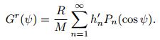
|
(6) |
From Eq.(2) to (4), it is not difficult to see that the crustal load deformation and gravity field variation can be inverted for by constructing the geodetic height changes and gravity changes as the measurement values, with the equivalent load water height for the observation equation of the parameters to be estimated, and using the appropriate parameter estimation algorithm.
Taking Eq.(6) into (4), the geodetic high changes at the CORS station (φ, λ) can be expressed as
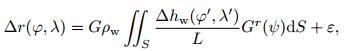
|
(7) |
where ε is the sum of the vertical deformation due to tectonics and groundwater balance. In the Three Gorges area, the tectonic vertical deformation is very small, groundwater level is basically in equilibrium each year, and the groundwater balance effect is not obvious. Therefore, ε is treated as random noise in this study.
In the same way, the gravity variation at the gravity station can be expressed as
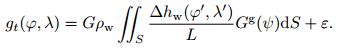
|
(8) |
The data used in this paper are mainly the following:
① The non-tidal geodetic height changes of the 26 CORS stations in the Three Gorges region. For the CORS network geodynamic correction calculation we adopt the IERS2010 Convention protocol with the solid tide, tide load, diurnal and semidiurnal atmospheric tide loads removed (Petit and Luzum, 2010; Wang et al., 2005). Setting the average value from October to December of 2010 as the benchmark, the CORS station ground hight monthly changes are available from January 2011 to June 2015.
② The non-tidal gravity changes of the 8 gravity stations in the Three Gorges area. The gravity stations are equipped with portable tidal gravity meters, with a continuous observation time span of 1~3 years. We remove the tides and ocean tide loading with the IERS2010 protocol and ignore the diurnal and semidiurnal atmospheric tide loads (Wei et al., 2012). Based on the average value of November 2010, the non-tidal gravity changes of the gravity stations were generated.
The CORS station and gravity station distributions are shown in Fig. 1 using diamonds and triangles.

|
Fig. 1 Locations of the CORS stations and gravity stations in the Three Gorges area |
③ The changes in the rivers and lakes in the Three Gorges area. Using the multi-temporal resources of the three high-resolution satellite images and the river/lake water level measurement data (Zhao et al., 2014), we calculated the monthly river/lake/reservoir equivalent water hight change.
④ The monthly variation of the atmospheric pressure in the Three Gorges area. Data from 77 meteoro-logical stations of China's terrestrial climate data from January 2011 to June 2015 is used for the atmospheric monthly variation of the gridded model in the Three Gorges area. The regional atmospheric residual load and the river and lake water loads are calculated us-ing Eq.(4) with an integral radius of no more than 2.5 degrees.
⑤ The global soil water model. The monthly global soil equivalent water height variation values are from the NASA God dard Space Center and the National Center for Environmental Prediction Global Land Surface Water Model (GLDAS). The effect of the soil moisture load is calculated using the spherical har-monic analysis method with the spherical harmonic co-efficients according to Eqs.(2) and (4).
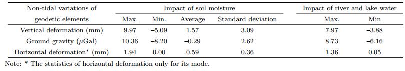
In Table 1, the maximum and minimum values of the influence of the soil water load and water load on the surface gravity, vertical deformation and horizontal deformation are statistically determined. In addition, for the horizontal deformation, only the module is statistically determined. From the Table 1, it can be seen that the magnitude of the influence of the two kinds of load on the vertical deformation is near 1 cm, and the influence on the horizontal deformation is very small.
|
|
Table 1 Statistics of the impact of soil water loading and the impact of river and lake water loading |
Taking each month as an independent computing unit, and taking the non-tidal geodetic height changes of the CORS stations as the measurement values, the observation equation is constructed using Eq.(7) with CORS data. Taking the non-tidal gravity changes of the gravity stations as the measurement values, the observation equation is constructed using Eq.(8) with gravity values. Removing the effect of the global soil moisture, the global model and the regional atmospheric residual load and the regional water loads of the lakes and reservoirs, the measurement equation to solve for the residual equivalent water height is constructed.
The comprehensive calculations of the CORS data and gravity station data can effectively improve the spatial resolutions and accuracies of the inversion results. The variations of the crustal deformations and the gravity field caused by terrestrial water load are equal to the sum of the influence of the soil water load, the water load of the rivers and lakes, and the residual water load. In this paper, we have calculated the land water load influence at the spatial resolution of 2′ ×2′, the time resolution of one month, and the time span from January 2011 to June 2015. In Table 2, the effect of the land water load from January 2011 to December 2014, and January to June of 2015 were statistically evaluated, so it is convenient to compare.
|
|
Table 2 Statistics of the impact of the load of the terrestrial water (monthly average) |
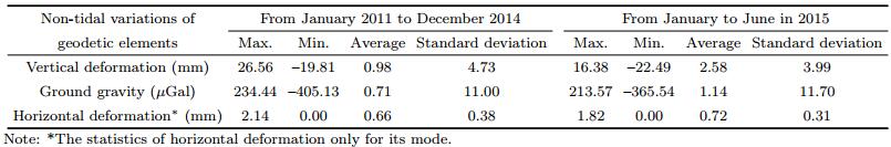
From Table 2, it can be found that the effect of land water load on the vertical deformation is at the centimeter level, and has little effect on the horizontal deformation but has an effect of up to hundreds of microgal gravity variations at the surface. The effects of the land water load on the crustal deformation are mainly reflected in the vertical direction.
To analyze the influence of the continental water load on the vertical crustal deformation and gravity changes, the vertical deformation and gravity changes at the CORS station locations are obtained by interpola-tion, as shown in Fig. 2. Fig. 2 lists the impacts of terrestrial water load at Hubei Jingmen (HBJM), Chongqing Changshou (CHSH), Zhenba (SNZB), Guiyang (GZGY), Mayang (HNMY), and Junlian (SCJU), a total of six CORS sites. From Fig. 2, we found obvious rules: when ground subsides, then ground gravity increases; when the ground rises gravity is reduced.

|
Fig. 2 The impact of the terrestrial water on the crustal vertical deformation and gravity changes at CORS sites |
To further illustrate the spatio-temporal variation characteristics of the effects of the terrestrial water load, this article plotted the crustal vertical deformation, the horizontal deformation, and the gravity changes caused by the terrestrial water change in March, June, September, and December of 2014, as shown in Figs. 3 to 5.

|
Fig. 3 Effect of the terrestrial water on the crustal vertical deformation (relative to November 2010) |

|
Fig. 4 Effect of terrestrial water on the crustal horizontal deformation (relative to November 2010) |

|
Fig. 5 Effect of terrestrial water on gravity changes (relative to November 2010) |
From Fig. 3, we can see that the biggest influence on the vertical deformation was caused by the terrestrial water in the southwest of Chongqing and the eastern part of Yichang. The largest change was apparent in September, consistent with the results of GRACE, and is mainly affected by the rainfall (Xu et al., 2013). The monthly data from January 2011 to June 2015 were analyzed and found that the influence of the land water on the vertical deformation was balanced.
The effect of terrestrial water on vertical deformation The effect of the terrestrial water on the crustal horizontal deformation has a strong directivity. Through the analysis of the images from January 2011 to June 2015, it is found that in August 2012 and 2013, and September 2014, there are convergent points of the horizontal deformation near Yichang city, with the cor-responding longitude and latitude coordinates of (110.2°E, 30°N), (111.2°E, 29.2°N) and (111.5°E, 30°N). In November of 2012 and 2013, and in December 2014, there are divergence points of the horizontal deformation in the vicinity of Chongqing, with the corresponding longitude and latitude coordinates of (106.8°E, 29.8°N), (106°E, 28.8°N) and (108.2°E, 29.8°N), as shown in Fig. 4. In Fig. 4, the color represents the modular value of the horizontal deformation, and the arrow represents the direction of the horizontal deformation.
To highlight the contrasting effects of each region, the values above 40 μGal and below -40 μGal are plotted with scale limits in Fig. 5. This study finds that the changes are mainly concentrated in the Three Gorges Reservoir and Jianghan Plain (approximately 30°E and 114°N in the figure), as shown in Fig. 5. It can be seen that the influence of the water load on the vertical deformation and the gravity changes in the Earth's crust are more obvious in the vicinity of the Three Gorges reservoir, in the vicinity of Chongqing and in the Jianghan Plain than elsewhere, as shown in Figs. 3 to 5.
5 COMPARISON TO GRACEAt the seasonal or shorter time scale, the time variable of the gravity field derived from GRACE mainly reflects the changes in terrestrial water storage. In this paper, we use the Helmholtz-Centre Potsdam-German Research Centre for Geosciences (GFZ) GRACE load calculation results for deformation and gravity field changes, products of GRACE-RL05a, which do not contain atmospheric loading effects and are mainly caused by terrestrial water load effects.
The monitoring results from the CORS network were compared to the monthly GRACE product, with a time span from January 2011 to December 2014 for a total of 42 months, as shown in Table 3.
|
|
Table 3 Comparison of the monitoring results of the CORS station network with the results of GRACE |
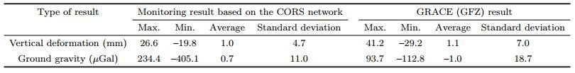
Comparing the statistical results of the CORS station network monitoring with the statistical results of the GRACE products, it can be seen that the CORS station network has the ability to monitor the vertical deformation of the Earth's crust and the changes of the ground level gravity. The annual variation of the crustal vertical deformation in the Three Gorges area is more than 30 mm, and the annual variation of ground level gravity is more than 100 μGal.
The influence of the crustal deformation and the gravity changes caused by the terrestrial water load in the Three Gorges area, based on the CORS network, is consistent with that of GRACE in its change trend and spatial distribution rules, as shown in Fig. 6. Fig. 6a and 6b show the influence of the water load on the ground level gravity changes. The influence of the terrestrial water load on the vertical deformation of the earth's crust is shown in Fig. 6c and 6d for comparison.

|
Fig. 6 Contrast curve of the impact of the terrestrial waters based on CORS and GRACE, separately |
To analyze the differences in both areas, the monitoring results from CORS are compared with those of GRACE in March of 2015, with the reference value subtracted, as shown in Fig. 7. Fig. 7a, 7c and 7e are the impact of the terrestrial water load based on the CORS network. 7b, 7d and 7f are the impact of the terrestrial water load based on GRACE. As can be seen in Fig. 7, there are differences in some areas, which may be caused by errors in the GNSS data processing or GRACE inversion (van Dam et al., 2007) and need further research.

|
Fig. 7 Comparison of the crustal deformations and gravity changes from the CORS network and GRACE measurements in March 2015 |
Based on the CORS station network and a small amount of gravity station data, the load deformation and gravity field method were used to monitor the impact of the terrestrial water load on the crustal deformation and gravity changes in the Three Gorges area. We found that the CORS station network has the ability to monitor the vertical deformation of the Earth's crust and the Earth's gravity change, and can reflect the influence of the fine-scale water migration. The influence of the water load on the crustal deformation is mainly reflected in the vertical direction while the influence on the horizontal deformation is small, and the influence on the gravity change is mainly concentrated in the Three Gorges Reservoir and the Jianghan Plain.
The crustal deformation and gravity changes caused by terrestrial water in the Three Gorges area as measured by the CORS network are highly consistent with GRACE in their distribution and trends, except for some parts of the area. However, the former has a higher spatial resolution.
ACKNOWLEDGMENTSThis work was supported by the National Natural Science Foundation of China (41374081, 41304009, 41474011). Thanks to the Ministry of Water Resources Information Center and the National Meteorological Information Center for providing hydrological and meteorological data. The Satellite Surveying and Mapping Application Center (NASG) provided information and image data; the Crustal Movement Observation Network of China, the Hubei Bureau of Surveying, Mapping and Geoinformation, Chongqing city Land Resources and Housing Surveying and the Planning Institute and other units and departments provided CORS station data. Thanks to the Institute of Earthquakes of the China Earthquake Administration for providing gravity station data. This paper is completed under the Geographic Conditions Monitoring Project 'Geological environment stability change monitoring in the Three Gorges area' provided by the National Administration of Surveying, Mapping and Geoinformation. We greatly appreciate the contributions of the units that participated in the project.
| [] | Argus D F, Fu Y N, Landerer F W. 2014. Seasonal variation in total water storage in California inferred from GPS observations of vertical land motion. Geophys. Res. Lett. , 41 (6) : 1971-1980. DOI:10.1002/2014GL059570 |
| [] | Blais J A R, Provins D A. 2002. Spherical harmonic analysis and synthesis for global multiresolution applications. J.Geod. , 76 (1) : 29-35. DOI:10.1007/s001900100217 |
| [] | Blewitt G, Lavallé D, Clarke P, et al. 2001. A new global mode of Earth deformation:Seasonal cycle detected. Science , 294 (5550) : 2342-2345. DOI:10.1126/science.1065328 |
| [] | Blewitt G, Clarke P. 2003. Inversion of Earth's changing shape to weigh sea level in static equilibrium with surface mass redistribution. J. Geophys. Res. , 108 (B6) : 2311. |
| [] | Colombo O L. 1981. Numerical Methods for harmonic analysis on the sphere. Report No. 310, Department of Geodetic Science, Ohio State University. |
| [] | Dang Y M, Zhang C Y, Chen J Y, et al. 2015. Modern Geodetic Datum[M]. Beijing: Surveying and Mapping Press . |
| [] | Davis J L, Elósegui P, Mitrovica J X, et al. 2004. Climate-driven deformation of the solid earth from GRACE and GPS. Geophys. Res. Lett. , 31 : L24605. DOI:10.1029/2004GL021435 |
| [] | Dong D, Fang P, Bock Y, et al. 2002. Anatomy of apparent seasonal variations from GPS-derived site position time series. J. Geophys. Res. , 107 (B4) : ETG 9-1-ETG 9-16. DOI:10.1029/2001JB000573 |
| [] | Farrell W E. 1972. Deformation of the Earth by surface loads. Reviews of Geophysics , 10 (3) : 761-797. DOI:10.1029/RG010i003p00761 |
| [] | Fu Y N, Argus D F, Landerer F W. 2015. GPS As an independent measurement to estimate terrestrial water storage variations in Washington and Oregon. J. Geophys. Res. , 120 (1) : 552-566. DOI:10.1002/2014JB011415 |
| [] | Hu X G, Chen J L, Zhou Y H, et al. 2006. Seasonal water storage change of the Yangtze River basin detected by GRACE. Science in China:Series D Earth Sciences , 49 (5) : 483-491. DOI:10.1007/s11430-006-0483-5 |
| [] | Jiang W P, Li Z, Liu H F, et al. 2013. Cause analysis of the non-linear variation of the IGS reference station coordinate time series inside China. Chinese J. Geophys. , 56 (7) : 2228-2237. DOI:10.6038/cjg20130710 |
| [] | Kusche J, Schrama E J O. 2005. Surface mass redistribution inversion from global GPS deformation and gravity recovery and climate experiment (GRACE) gravity data. J. Geophys. Res. , 110 (B9) : B09409. |
| [] | Petit G, Luzum B. 2010. IERS Conventions 2010. International Earth Rotation and Reference Systems Service, IERS Technical Note No. 36. Verlag des BundesamtesfürKartographie und Geod-sie, Frankfurt am Main. |
| [] | Sheng C Z, Gan W J, Liang S M, et al. 2014. Identification and elimination of non-tectonic crustal deformation caused by land water from GPS time series in the western Yunnan province based on GRACE observations. Chinese J. Geophys. , 57 (1) : 42-52. DOI:10.6038/cjg20140105 |
| [] | Su X L, Ping J S, Ye Q X. 2011. Terrestrial water variations in the North China Plain revealed by the GRACE mission. Sci. China Earth Sci. , 54 (12) : 1965-1970. DOI:10.1007/s11430-011-4280-4 |
| [] | Tapley B D, Bettadpur S, Watkins M, et al. 2004. The gravity recovery and climate experiment:Mission overview and early results. Geophys. Res. Lett. , 31 (9) : L09607. |
| [] | Tesmer V, Steigenberger P, Van Dam T, et al. 2011. Vertical deformations from homogeneously processed GRACE and global GPS long-term series. J. Geod. , 85 (5) : 291-310. DOI:10.1007/s00190-010-0437-8 |
| [] | van Dam T, Wahr J, Milly P C D, et al. 2001. Crustal displacement due to continental water loading. Geophys. Res.Lett. , 28 (4) : 651-654. DOI:10.1029/2000GL012120 |
| [] | van Dam T, Wahr J, Lavallée D. 2007. A comparison of annual vertical crustal displacements from GPS and Gravity Recovery and Climate Experiment (GRACE) over Europe. J. Geophys. Res. , 112 (B3) : B03404. |
| [] | Wahr J, Molenaar M, Bryan F. 1998. Time variability of the Earth's gravity field:hydrological and oceanic effects and their possible detection using GRACE. J. Geophys. Res. , 103 (B12) : 30205-30229. DOI:10.1029/98JB02844 |
| [] | Wang L S, Chen C, Zou R, et al. 2014. Using GPS and GRACE to detect seasonal horizontal deformation caused by loading of terrestrial water:A case study in the Himalayas. Chinese J. Geophys. , 57 (6) : 1792-1804. DOI:10.6038/cjg20140611 |
| [] | Wang M, Shen Z K, Dong D N. 2005. Effects of non-tectonic crustal deformation on continuous GPS position time series and correction to them. Chinese J. Geophys. , 48 (5) : 1045-1052. |
| [] | Wang W, Wang P, Cui W. 2015. A comparison of terrestrial water storage data and multiple hydrological data in the Yangtze River basin. Advances in Water Science , 26 (6) : 759-768. |
| [] | Wei J, Li H, Liu Z W, et al. 2012. Observation of superconducting gravimeter at Jiufeng seismic station. Chinese J.Geophys. , 55 (6) : 1894-1902. DOI:10.6038/j.issn.0001-5733.2012.06.010 |
| [] | Wu X P, Heflin M B, Ivins E R, et al. 2006. Seasonal and interannual global surface mass variations from multisatellite geodetic data. J. Geophys. Res. , 111 (B9) : B09401. |
| [] | Xu M, Ye B S, Zhao Q D. 2013. Temporal and spatial pattern of water storage changes over the Yangtz river basin during 2002-2010 based on GRACE satellite data. Progress in Geography , 32 (1) : 68-77. |
| [] | Zhao F, Zhu F Q, Feng Z K, et al. 2014. Study on water body information extraction method based on ZY-3 imagery. Bulletin of Surveying and Mapping (3) : 25-28. |
| [] | Zhou X H, Wu B, Peng B B, et al. 2006. Detection of global water storage variation using GRACE. Chinese J. Geophys. , 49 (6) : 1644-1650. |