2 Chengdu Center, China Geological Survey, Chengdu 610081, China;
3 Ministry of Education Key Laboratory of Earth Exploration and Information Technology, Chengdu University of Technology, Chengdu 610059, China
Beiya gold ore is a super-large gold ore with more than 200 tons of explored gold reserves and high exploration degree. We trapped various ore bodies in Beiya ore district by drilling, which can provide sufficient geological data and establish the important foundation for verifying the validity of study methods. The superlarge gold-polymetallic deposit in Beiya can be divided into five subtypes: alkali-rich porphyry contact zone skarn, interlayer fracture zone, lithology interface, vein and eluvium talus (He, 2013). Alkali-rich porphyry contact zone skarn type deposit is one of the most important types of deposits in Beiya gold ore district with the largest ore body. Wandongshan section consists of gold-iron-polymetallic deposits, and Hongnitang section mainly consists of iron-polymetallic ore and belongs to skarn deposit. It is well known that skarn deposits have important industrial value. Skarn deposits are the most important sources of tungsten all around the world (over 70% of the world's tungsten production from these deposits) and are main sources of copper, iron, molybdenum and zinc. These deposits hold a special status in China, for example, skarn iron ore ranks first in terms of high grade ore reserve (38.0%) (Zhang, 2009). Hence, there is an urgent need to conduct the locating method research on the skarn iron deposit.
Before 1982, Beiya ore district mainly produced lead-zinc ores and after that, with the improvement of exploration degree it began to produce tons of gold resources. In 1988, the explored gold resources amounted to 54 tons while producing associated resources of iron, silver, copper, lead and zinc. As of 2013, the explored gold reserve exceeded 200 tons and the deposit was classified as super-large gold-polymetallic deposit. Researchers (Liang et al., 2000; Yan et al., 2003; Cui et al., 2003; Guan, 2008; Yang et al., 2014, 2015) carried out a lot of research in Beiya region and had achieved significant results. All researches were based on one speculation and hypothesis of geophysical, geochemical and remote sensing anomalies and did not study the different deposits subtypes separately.
Beiya gold-polymetallic deposits are constrained by porphyries, structures and stratums etc., and contact alteration zones between porphyries and carbonatite are the favorable ore-forming portions of skarn deposits (Yan et al., 2003; Xu et al., 2007; Yang et al., 2010; He et al., 2013; Li, 2013). Researchers used multiple geological, geophysical means, extracted abnormal information and identified porphyries contact zones with ore-prospecting potential. In respect of prospecting of space contact relation between porphyries-structuresstratums, seismic exploration method and electric method have significant advantages and researchers have achieved good exploration results (Colin et al., 2009; Gao et al., 2010; Jia et al., 2011; Dennis et al., 2012; Mohamed et al., 2013; Wang, 2013). It is well known that the seismic exploration method has high resolution with accuracy to meters, and plays a key role in the oil exploration. However, it is not widely used in metal ore-prospecting due to its high exploration cost, difficulty in receiving, processing and interpretation. In consideration of actual situation in the ore district (strong human interference, such as high-voltage lines, vehicles, villages and pipelines etc.), researchers adopted a controlled source audio magnetotelluric with strong anti-interference capacity, conducted interpretation and established a stratum interpretation model, subject to the constraints of geological data on routes. On the condition that the established stratum interpretation model acted as initial model and the corrected density values obtained from forward calculation acted as parameters, researchers conducted constrained inversion of gravity anomaly, trapped the contact relation between porphyries and surrounding rocks, and determined the favorable ore-forming portions, subject to the constraints of magnetic abnormal information. Researchers conducted in-depth study on some of study methods separately and did not conduct an integrated study (Wang et al., 2013; Bai et al., 2002; Zhu et al., 2003; Liu et al., 2004; Wang et al., 2010). Researchers (Xiao et al., 1999; Chen et al., 2008) made a lot of useful explorations on ore prediction by adopting the multivariate information techniques, obtained a series of important results which were based on big data on the surface and conducted ore-prospecting prediction. On the basis of geologic characteristic and ore-formation law research in Beiya, western Yunnan, and using geophysical information and other multivariate information, this paper analyzes ore-forming factors in various stratums, establishes the ore body emplacement model, and proposes a locating and forecast method for the concealed skarn iron deposits, which is applicable to Beiya and other similar ore-forming geological conditions.
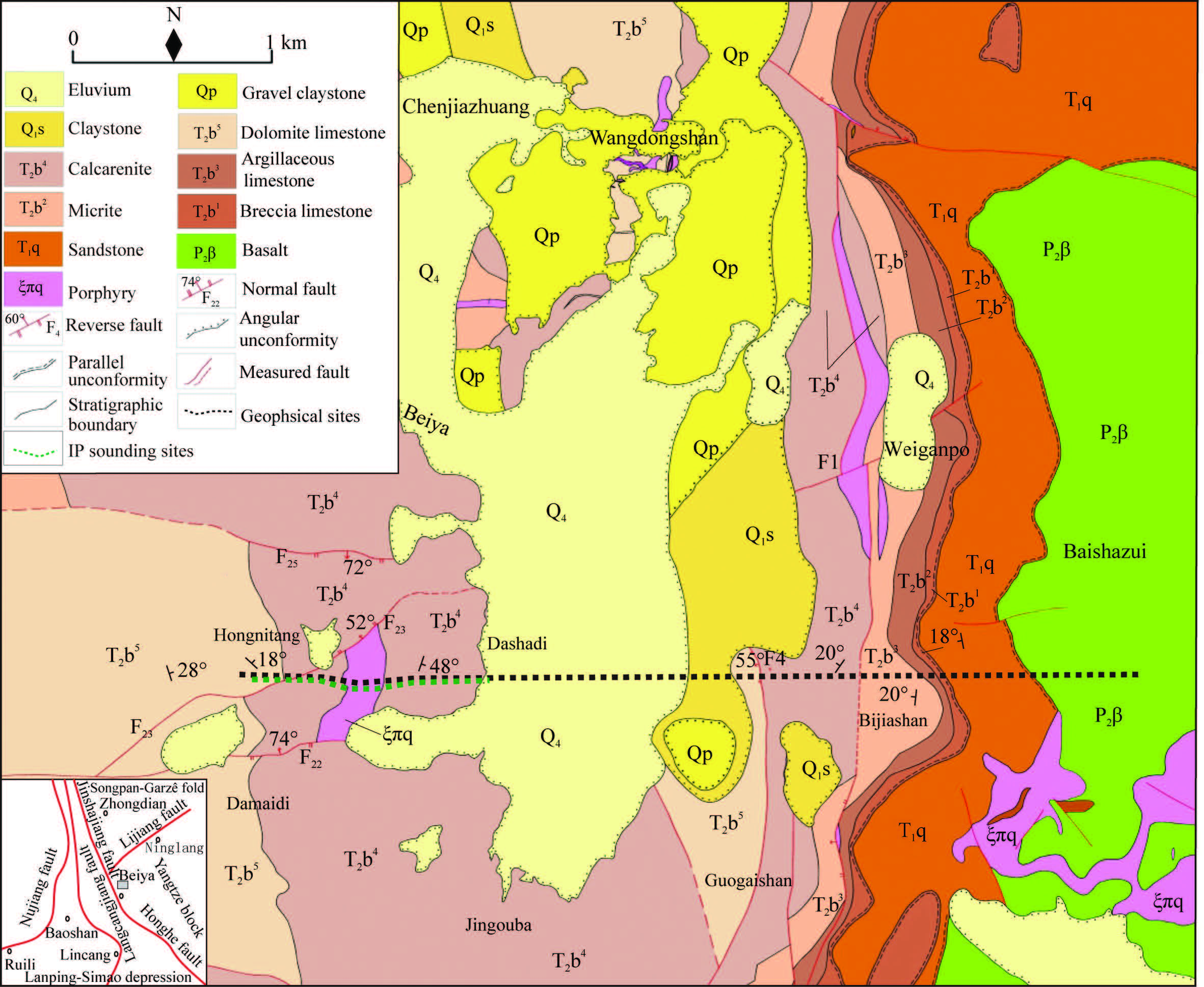
2 GEOLOGY INTRODUCTIONThe study area is located to the east of Jinsha River-Red River fault zone, on the Dali-Ninglang northeastern tectonic zone and belongs to Yanyuan-Lijiang marginal depression zone in the Upper Yangtze block. Fig. 1 illustrates the geological and geophysical measurement points in the study area. The exposed stratums of study area include the upper Permain Emeishan basalt (P2β), the lower Triassic Qingtianbao group (T1q), the middle Triassic Beiya group (T2b), the Pleistocene of Quaternary Sheshan group (Q1s), the Pleistocene (Qp) and Holocene (Q4). The main components of the middle Triassic Beiya group (T2b) include dolomitic calcarenite, dolomite, iron calcarenite, argillaceous limestone and vermicular limestone. The lower Triassic Qingtianbao group (T1q) is exposed in the east of the study area, distributed in the south-north direction, and mainly composed of yellow green-deep celadon thin-medium layered arkose and hornfels greywacke. The upper Permain Emeishan basalt is exposed in the east of the study area, and mainly composed of celadon-dark green basalt, the surface of which is badly weathered and damaged. The magmatic rock exposed in Beiya mainly includes hypabyssal intrusive alkali-rich porphyry formed during the Himalayan period. The Beiya syncline is the main folding in the ore district, located on the raised south end of Songgui compound syncline; it is a secondary structure of Heqing-Songgui compound syncline, and is a gentle brachy-syncline with synclinal axis in NNE direction. Stratum T2b3-T2b5 is exposed in the west wing of the syncline, inclining to east, and stratum T2b1-T2b5, T1q and P2β in the east wing, inclining to west.
|
Fig. 1 Map showing geological and geophysical sites |
Porphyries exposed in the study area mainly include limestone, dolomite, basalt, quartz-orthophyre and so on. Based on these porphyries, we conducted physical characteristics measurements in the study area and carried out the statistical analysis of physical characteristic difference between porphyries. We collected 173 pieces of specimens for various types of porphyries and the measured physical characteristics including density, susceptibility, resistivity and polarizability. According to statistics, the resistivity, polarizability, density, susceptibility and other physical characteristics of limestone are similar to dolomite and in view of geophysical method resolution, it is impossible to distinguish these two type porphyries from each other, and hence, Beiya group limestone and dolomite are both treated as carbonatite. Iron ore specimens were collected from Wandongshan quarry which is distributed in the external contact zone of porphyries.
Table 1 summarizes the physical characteristics of porphyries in the study area as follows: carbonatite with high resistivity and low polarizability; sandstone with low resistivity and polarizability; basalt with medium-high resistivity and medium-low polarizability; porphyry with medium-low resistivity and medium-high polarizability; and iron ore with low resistivity and high polarizability. There is great difference in resistivity between porphyries in different stratums, and the stratigraphic distribution can be divided based on the resistivity anomaly. Porphyry is less dense than sedimentary rock, belongs to low-density rocks in the study area and could cause gravity anomaly, therefore the low-density of porphyries can be used to determine the geometry of porphyries. Iron ore and basalt are high-susceptibility, but sedimentary rock and porphyry are weak-susceptibility. By applying the electromagnetic sounding method, we could determine the distribution of basalt so as to understand the high susceptibility effect caused thereby. In addition, we could determine the favorable ore-forming portions after eliminating the interference of basalt and applying magnetic anomaly data. The difference between ore and surrounding rocks (iron ore and porphyry, carbonatite) in polarizability reaches 2.37%, and polarizability parameters can be used to efficiently locate the ore body.
|
|
Table 1 Statistics of physical parameters of rocks in Beiya area |
Deposits of specific genetic type are produced in specific geological environment, such as contact metasomatic deposits are produced in the contact zones between intermediate-acid rocks and carbonatite and adjacent area (Zhai et al., 2011). Only a few contact zones belong to concentrated ore-forming zone, and the favorable ore-forming contact zone can only be determined on the condition that geological and geophysical multivariate information is provided.
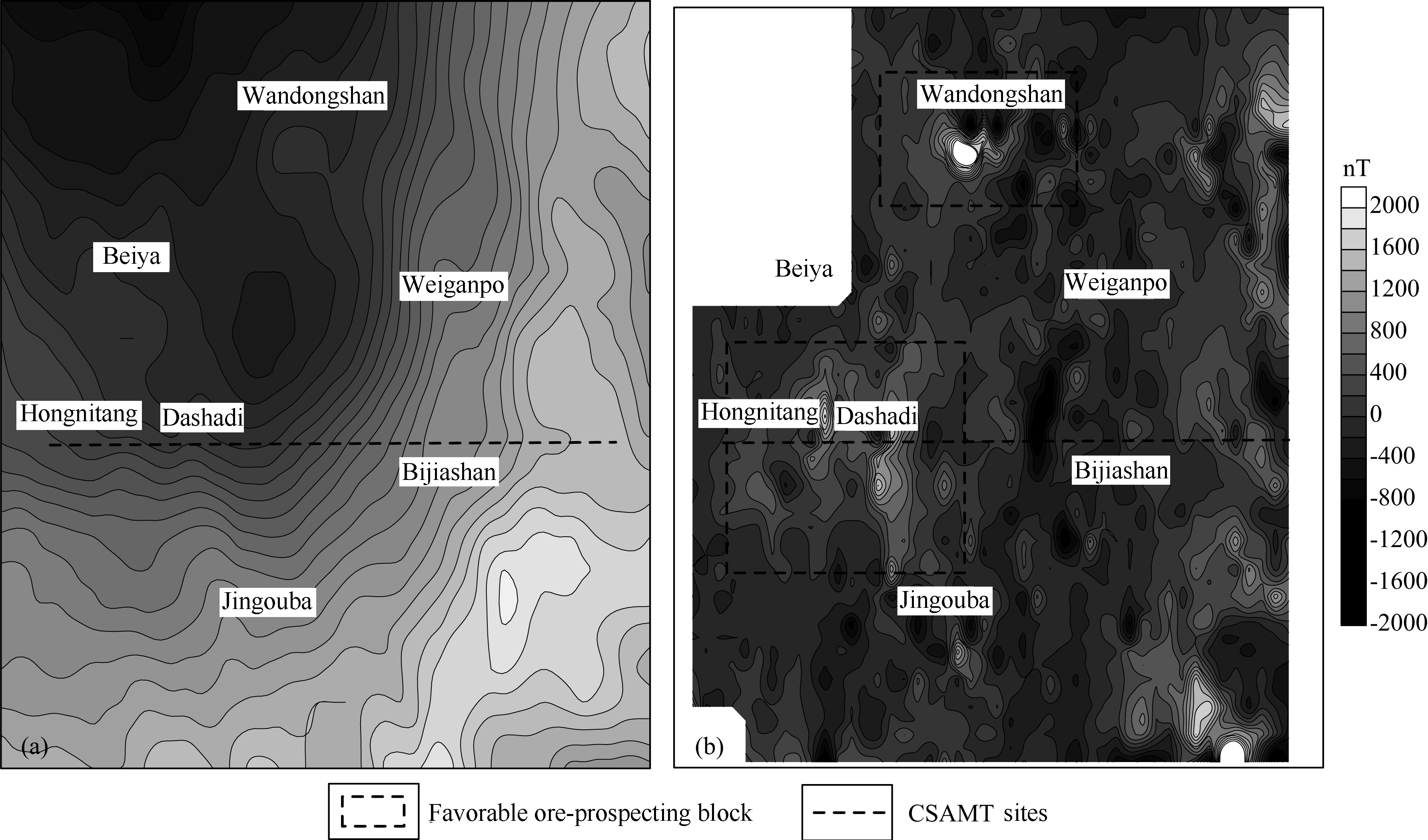
4.1 Optimal Selection of Favorable Ore-Prospecting BlockAs shown in Fig. 2a, Bouguer gravity anomalies in Beiya are concentrated in negative anomaly area with amplitude from-251.8 to-240.2 mGal and coverage area of 42 km2. The Bouguer gravity anomalies in Beiya are in arc-shaped with high value in the northwest and low value in the southeast. The Bouguer gravity anomaly arc-shaped gradient zones run from north to south and Weiganpo, Hongnitang, Bijiashan, Jingouba area on the east of Wandongshan are on the Bouguer gravity anomaly arc-shaped gradient zones, wherein Wandongshan and Beiya village are located in the North Central low Bouguer gravity anomaly zones. In general, the changes in Bouguer gravity anomaly are reverse to those of terrain altitude (Wang et al., 2005).
|
Fig. 2 Gravity and magnetic anomaly maps in Beiya (a) Bouguer gravity anomaly; (b) Local magnetic anomaly |
Figure 2b shows local magnetic anomalies in the study area and the magnetic anomaly amplitude varies from-2000 to 3000 nt, mainly including positive magnetic anomalies. High magnetic anomalies are distributed in the east and west zone. East high magnetic anomaly zones are located in the region to the east of Wandongshan and Bijiashan where anomalies are continuous. West high magnetic anomaly zones are located in the region of Wandongshan, Dashadi and Jingouba.
Surface geological data showed that the east region of Guiganpo-Bijiashan mainly produced basalt, and corresponded to high gravity and magnetic anomaly zones. In combination of physical characteristics of porphyries, basalt has high gravity and high susceptibility, and thus high gravity and magnetic anomaly zones are caused by Permain basalt. Therefore, the research on skarn deposit is not focusing on high gravity and magnetic anomaly zone on the east of study area. Wandongshan and Hongnitang sections exposed porphyry and Triassic carbonatite and satisfied the ore-foriming geological conditions for skarn deposit, showing low gravity and high susceptibility. Therefore, these sections could be considered as favorable enriched portions of skarn deposit and hence can be divided into two favorable sections, as shown in the black dotted bordered rectangle in Fig. 2b. It has been proved that gold ore body exists in Wandongshan section and is being explored. The morphological features of gravity-magnetic anomaly in Hongnitang have some similarities to Wandongshan. Whether or not ore body exists in Hongnitang section is the primary objective of the research and need further study in the future.
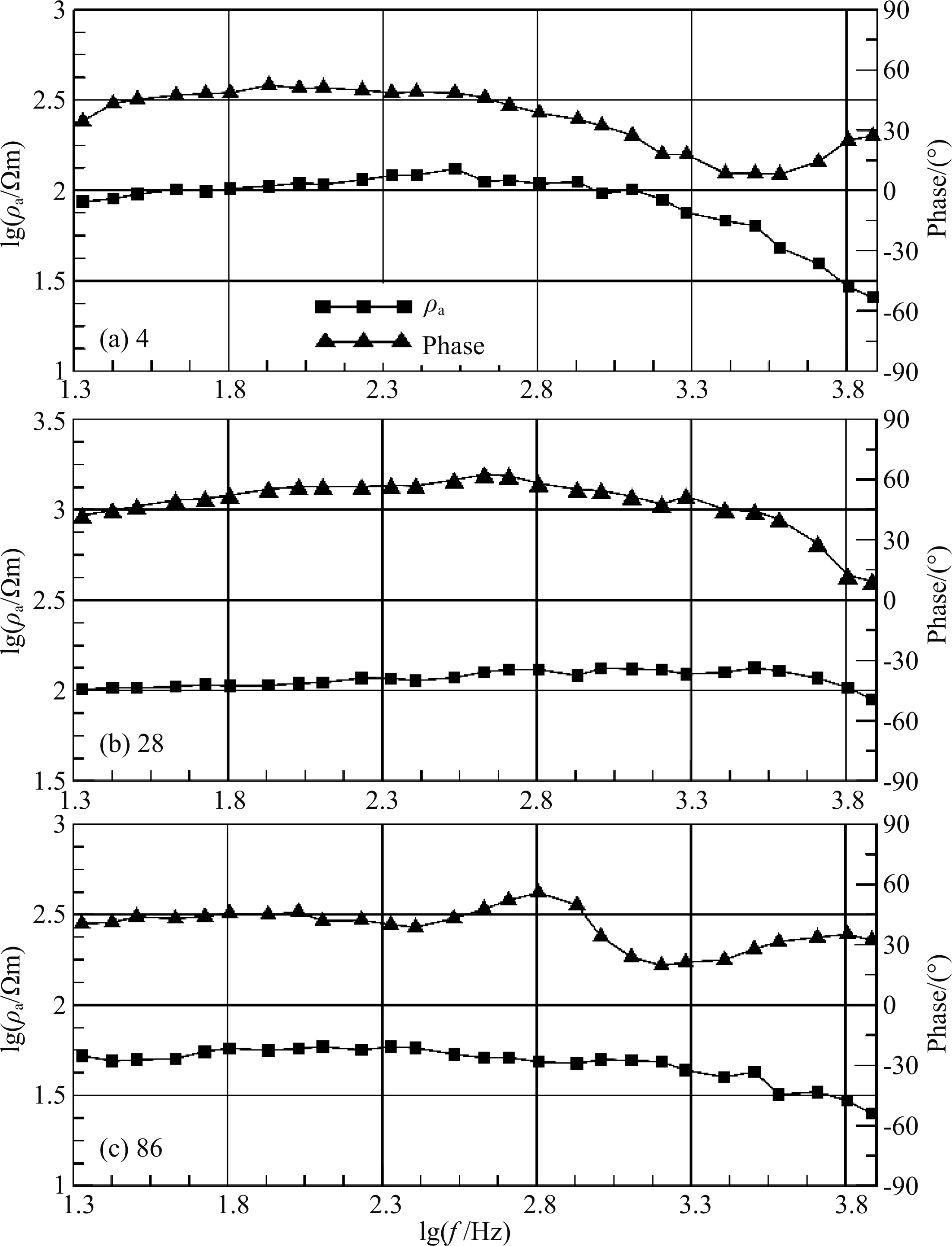
4.2 CSAMT Stratum Interpretation ModelSet 3 CSAMT measurement points respectively in Hongnitang section (as shown in Fig. 3a), to the east of Dashadi (as shown in Fig. 3b) section, and to the south of Bashazui (as shown Fig. 3c) section. It can be seen from Fig. 3 that the overall form of apparent resistivity curve on points 4 and 28 was K-shaped, and the explored stratum included Beiya group, Qingtianbao group and Emeishan basalt. The frequency band of 3.3 to 3.9 showed the low resistivity of the quaternary ground surface, the frequency band of 2 to 3.2 verified that T2b has the characters of high resistivity, and the frequency band of 1.3 to 1.9 represented the comprehensive response between Qingtianbao group clasolite T1q and Permain Emeishan basalt P2β. The sounding curve on measurement point 86 reflected Emeishan basalt, and the ground basalt had the characters of low apparent resistivity and small changes in resistivity for medium-low frequency band as a result of weathering and denudation. The form of the sounding curves as shown in Fig. 3 is conformable to actual formation conditions.
|
Fig. 3 Typical sounding curves of CSAMT in the study area |
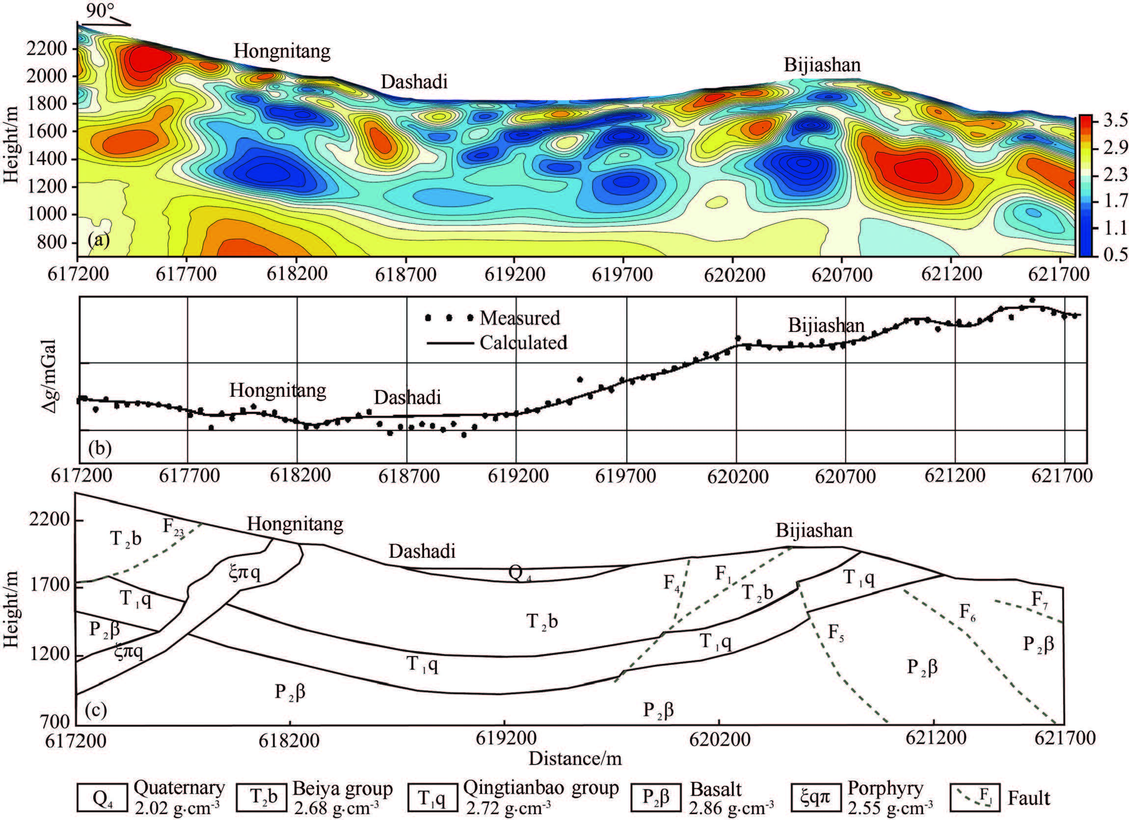
As shown in Fig. 4a, the exposed stratum on the western section of the profile was T2b, and the midshallow part of resistivity structural model showed high resistivity anomaly, which was caused by Beiya group carbonatite. The high resistivity anomaly zone at the bottom of the profile of the section was caused by the basement basalt, and the Qingtianbao group clasolite with low resistivity conformably contacted the basalt with high resistivity anomaly on the top interface. The electrical characteristics of the mid-shallow part showed as high and low resistivity stripped or massive anomaly, which were caused by Beiya group carbonatite stratum. Under the influence of tectonic stress, Beiya group carbonatite was not easily deformed, and hence often caused tectonic fracture, interlayer fracture zone development and karst tectonic development (Mo et al., 2008). Therefore, in the middle section of profile, i.e., core of Beiya syncline, the high and low resistivity stripped or massive anomaly was caused by Beiya group carbonatite. The electrical property in the intermediate layer of syncline core showed as complete low resistivity anomaly zone which was caused by Qingtianbao group clasolite, and the electrical properties in the basement layer of syncline core showed as layered and continuous mediumhigh resistivity anomaly zone caused by basalt. The stratum exposed in the region on the east to Bijiashan was relatively complete and it is possible to conduct reasonable geological interpretation of controlled resources step by step based on the geological data.
|
Fig. 4 Geophysical anomalies and interpretation (a) Resistivity structure model; (b) Measured and fitted curves of gravity anomalies; (c) Stratum interpretation model. |
Based on the routes geological data and combined with resistivity structural model, this paper determines the contact relations between main stratums in the study area, interprets faults and establishes the stratum interpretation model as shown in Fig. 4c, which provides the constrained support for the fitting of gravity anomaly. It is noted that there are two vertically distributed low resistivity anomalous bodies on the turning ends on both sides of Beiya syncline core. Because the gap at the turning place of syncline structure is relatively large which facilities the flow of ore fluid, and hence the turning places are the favorable skarn and ore bodyforming portions (Mo et al., 2008). Hongnitang porphyries are distributed in the western turning ends which cut through Beiya group stratum, and the turning ends are favorable ore-prospecting spaces. Thus the eastern turning ends of Beiya syncline have the similar resistivity features to Hongnitang section. Meanwhile, factures F1 and F4 act as the porphyries-controlling factures in the research and control the distribution of porphyries. Does Bijiashan section have ore-prospecting potential?
4.3 Porphyries Interpretation ModelFrom the Gravity Anomaly △g curve shown in Fig. 4b, the gravity anomaly △g is negative and is low in west and high in east. The gravity curve on the west wing of syncline, i.e., Hongnitang section, is flat, and the anomaly amplitude is low and has little change; from the core of syncline to the west wing, the gravity anomaly △g increases sharply which is significantly associated with basalt which was firstly buried under coverage, then became shallow and finally exposed on the ground. As geological data show, porphyries exposed in Hongnitang section run in near south-north direction with an inclination to west, are outcropped in the form of stocks, and intrusively contact the Beiya group stratum with a dip angle of 35° to 40°, with the lithology of quartzorthophyre. The resistivity structural model discloses the subsurface distribution of Hongnitang porphyries, as shown in Fig. 4c.
During the measurement of densities for each stratum and rock, the density values measured during the physical characteristics testing are taken as the initial values and then the forward calculation is conducted by establishing various models in order to highlight gravity anomaly caused by porphyries. By correcting the initial density values and comparing the results of forward modeling, the densities can be determined as follows: density value of Beiya group carbonatite density is 2.68 g·cm-3; density value of Qingtianbao group clasolite is 2.72 g·cm-3; density value of Emeishan basalt is 2.86 g·cm-3; and density value of quartz-orthophyre is set at 2.55 g·cm-3. The constrained inversion is conducted with the gravity anomaly of this profile, with stratum interpretation model as initial model, the corrected density value of forward calculation as parameters and the porphyry as the main target of fitting.
As shown in Fig. 4b, during fitting, the difference between △gm curve and △gc curves in Dashadi section is increased and the fitting result is not ideal, however the fittings in other sections can be conducted successfully. An attempt was made to reduce the difference between △gm and △gc by modifying the geometry of each stratum. In Dashadi section △gm < △gc, however, it is not reasonable to attribute local low gravity anomaly to Beiya group carbonatite and it shall attribute to low density body. In view of density values of each stratum in the study area, this low density anomaly should be caused by porphyry. As the same implies, concealed porphyry in Dashadi section intruded from Hongnitang section along the weak stratum, i.e., concealed porphyries in Dashadi section is the branch of porphyries in Hongnitang section. Based on this assumption, even if the model was re-modified, the human-machine interactive inversion was conducted and the geometry of porphyries was adjusted for many times, Hongnitang section to Dashadi section still showed △gm > △gc and hence there are still some problems with this presumptive model. By separating Hongnitang porphyries from Dashadi concealed porphyries as two independent porphyries, establishing models and conducting inversion, fitting curves as shown in Fig. 5a were obtained and △gm is approximate to △gc.
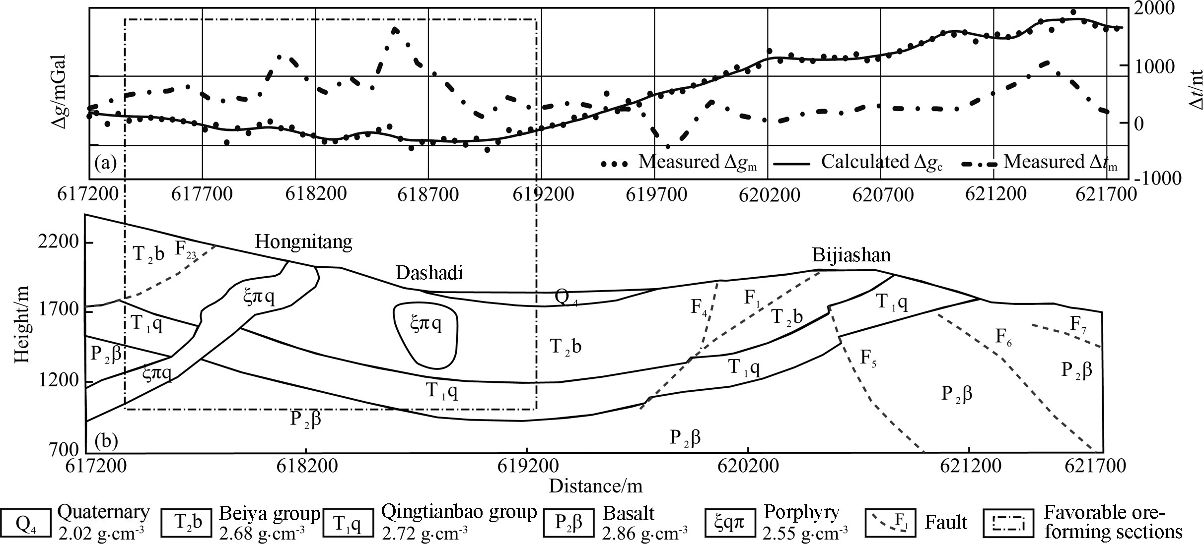
|
Fig. 5 Gravity and magnetic anomaly curves and interpretation (a) Gravity and magnetic anomaly curves; (b) Porphyry interpretation model. |
In the lower west corner of the resistivity structural model (Fig. 4a), the medium resistivity zone cuts basalt through, wherein the medium resistivity zone is used as channel of Hongnitang porphyries during uptrusion and is outcropped to the ground surface. The continuity of resistivity in the middle of profile suggests that the basalt is relatively complete and there is no channel for upturn of intermediate-acidic porphyries, therefore it is concluded that suspended Dashadi porphyry intruded from the north of the profile to the south. Hence, the porphyries interpretation model as shown in Fig. 5b is established which defined the contact relation between porphyries and carbonatite. Research suggests that there are Beiya group carbonatite and its intruded porphyry in the Hongnitang section to Dashadi section which are necessary ore-forming conditions for skarn deposit and the contact zone between these two sections is the favorable ore-prospecting spaces. It was found that there were contact metasomatic alteration and ferritization in the upper contact zone of Hongnitang porphyries during the geological observation of routes, which provided important leads for ore-prospecting. Based on above analysis, favorable ore-forming sections could be determined as shown in the dotted box of Fig. 5.
5 LOCATION AND PREDICTION OF ORE BODYSkarn deposit contains various sulfide minerals, such as pyrite, chalcopyrite, sphalerite and galena and could cause strong polarizability anomaly. The induced polarization method is an important method for prospecting concealed deposits (Zhang et al., 2009) and it could utilize susceptibility and polarizability information to determine whether there are minerals or not directly and efficiently.
From the magnetic anomaly △t curve in Fig. 5, magnetic anomaly △t was high on both ends and low in the middle. The peak value 1608 nT appeared in Hongnitang section to Dashadi section which belonged to high magnetic anomaly region and magnetic anomaly △t amplitude varied from 350 to 1000 nT, wherein the anomaly is distributed in jagged shape and on the contact zone of porphyries. In view of physical characteristics, porphyry and sedimentary rock have weak susceptibility and could not cause such high local magnetic anomaly. Emeishan basalt has strong susceptibility, however it could not cause high local magnetic anomaly because it was buried in deep. Once the influence of porphyries, stratum and basalt were excluded, the only possible cause for local high magnetic anomaly in Hongnitang section to Dashadi section could be the skarn zone or magnetite.
To the west of Dashadi and Bijiashan, most of magnetic anomaly △t amplitudes are less than 200 nT. Based on the resistivity structural model, the east turning end of syncline core, i.e., Bijiashan section has the ore-prospecting potential and the magnetic anomaly in this section is in the form of stepped shape with low amplitude value. The anomaly could be caused by the thin-layer skarn or magnetite or fracture in the superficial layer. Because the anomaly amplitude is small, and thus the local anomaly as shown in Fig. 4c can be interpreted as a result of fault. To the east of Bijiashan, the magnetic anomaly △t gradually increased till the peak value and then decreased, and the burial depth of underlying Emeishan basalt gradually became shallow and then outcropped on the ground which were caused by basalt high susceptibility.
The rock interpretation model and local high magnetic anomaly indicated that the dotted area as shown in Fig. 5 is the contact zone with ore-prospecting potential, and it is speculated that there is a high possibility that concealed skarn or skarn iron ore deposit existed in this area, and there is a need to conduct the induced polarization gradient array and sounding work.
As shown in Fig. 6a, apparent polarizability anomaly is low on both ends and high in the middle. The overall apparent polarizability amplitude in Hongnitang section is higher than Dashadi section. The apparent polarizability Ms amplitudes in Hongnitang section vary from 2.1% to 4.8%; the maximum anomaly could reach 5.29% and belongs to high polarizability anomaly. The apparent polarizability Ms amplitude in the west of Dashadi section is around 2% and belongs to medium polarizability anomaly. However, the apparent polarizability amplitude in the east of Dashadi section is small and it seems that there is no valid polarizability anomaly. In combination of apparent polarizability information, it is possible to conduct induced polarization sounding from the west of Hongnitang section to the west of Dashadi section by further narrowing down the exploration scope.
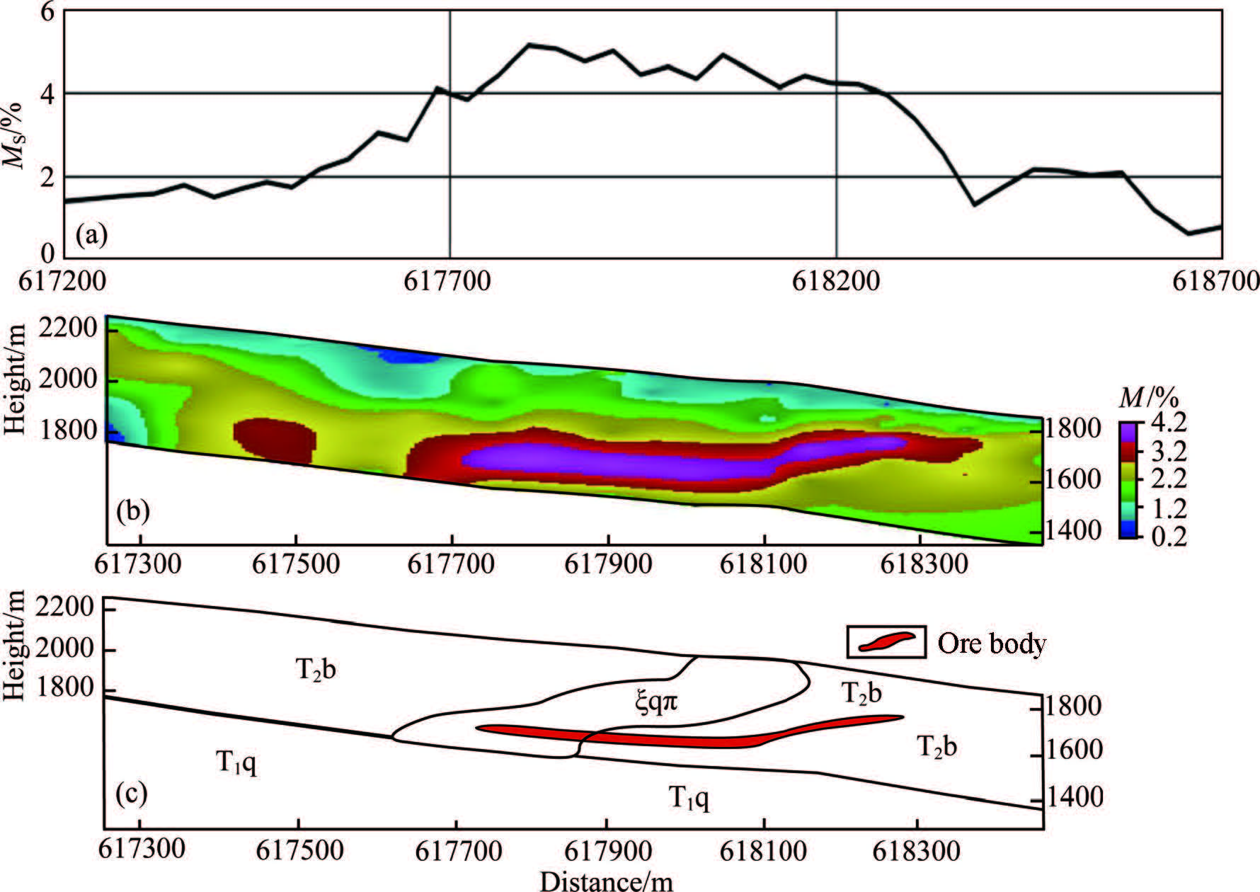
|
Fig. 6 Polarizability anomalies and ore body interpretation model (a) Apparent polarizability curve; (b) Polarizability structure model; (c) Ore body interpretation model. |
From the polarizability of induced polarization sounding method as shown in Fig. 6b, polarizability M is low in shallow and high in deep and is distributed in the form of stripped or massive shape. In the high polarizability M > 4% core area, the anomaly is enclosed and distributed on the lower part of contact zones between Hongnitang porphyries and Beiya group carbonatite, including the internal contact zone and external contact zone, which are the favorable contact-metasomatic deposit-forming portions, and the high polarizability anomaly is caused by ore. The ore interpretation model as shown in Fig. 5c was established based on the porphyry interpretation model as shown in Fig. 5b.
6 INTEGRATED INTERPRETATION GEOLOGICAL MODELThe overall geological profile of exploratory line as shown in Fig. 7b is a wide and flat syncline structure, and the syncline core is covered by quaternary stratum from the bottom to the top in the sequence of Permain basalt, lower Triassic Qingtianbao group clasolite and middle Triassic Beiya group carbonatite. Both wings of syncline developed several near south-north factures with the rock intrusion in the west wing of the syncline and the lithology of quartz-orthophyre, and the contact zone between porphyries and surrounding rocks developed skarn alteration associated with magnetite, ferritization. Porphyries are in stripped shape and outcropped in the form of layer.
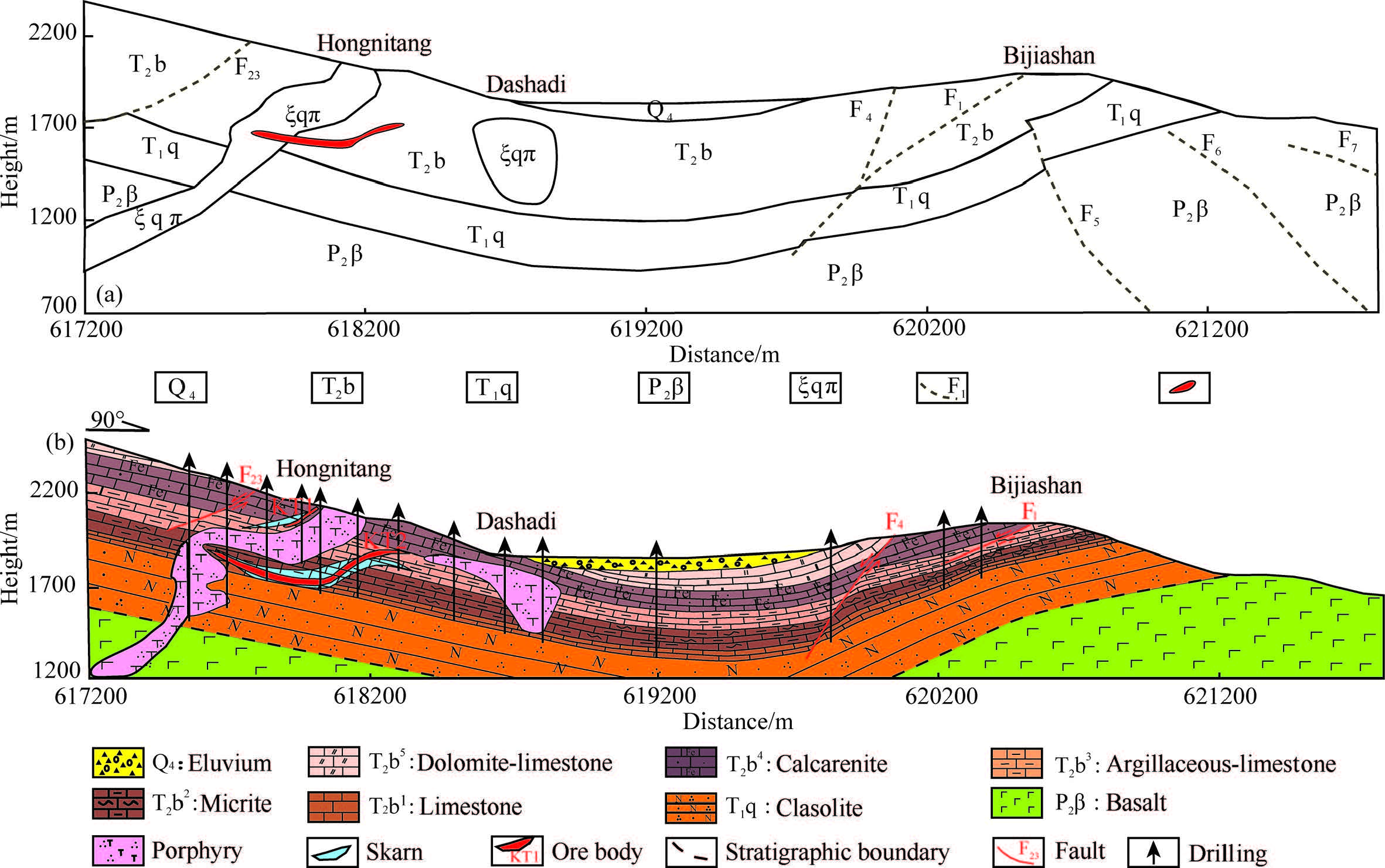
|
Fig. 7 Integrated interpretation model and geological model of exploratory line (a) Integrated interpretation model; (b) Geological model of exploratory line. |
The integrated interpretation geological model as shown in Fig. 7a was established based on the rock interpretation model as shown in Fig. 5b and ore interpretation model as shown in Fig. 6c. By comparing the geological model of exploratory line in Fig. 7b, it is easy to find that the integrated interpretation geological model can reflect the distribution of syncline structure and faults F1, F4 and F23 in a better way; the fracture F4 obliguely intersects with the fracture F1 at certain depth, which provides the geophysical evidence that "F4 is the steep angled extension fracture on the upper wall of F1" (Mo et al., 2008) and interpreted 3 concealed fractures to the east of Bijiashan at the same time. Constrained by the resolution, the geophysical method cannot interpret the geometry of porphyries as fine as engineering controls, but it can identify the intrusive channel of porphyries which has instructive importance to determining ore-prospecting direction in the process of oreforming mode research. The construction controls KT1 and KT2 ore bodies and the integrated interpretation geological model displays the corresponding huge and deep ore body KT2. Based on the geological model of exploratory line, ore body KT2 is produced on the external contact zone between porphyries and Beiya group carbonatite, and the interpreted ore bodies are distributed on the internal contact zone of porphyries. Skarn ore bodies produced in Wandongshan section are mainly distributed on the external contact zone between porphyries and surrounding rocks, and the internal contact zone between porphyries and surrounding rocks does not contain minerals or contains little minerals. The interpretation of Hongnitang quartz-orthophyre shown in Fig. 7a does not conform to the ore-forming features of skarn deposits, and a more reliable rock interpretation model meeting the actual geological conditions may be established by further modifying the lower border of Hongnitang porphyries, establishing a new model and re-conducting the inversion of gravity data. Hence, the research on the ore-forming laws of deposits could increase the interpretation precision of geophysical method. For the thin ore body KT1 in the shallow layer, the profile of polarizability as shown in Fig. 6b displays a small scale, medium amplitude polarizability anomaly and detailed interpretation was not conducted.
7 EXPLORATION MODE AND COMBINATION OF METHODSBy comparing the integrated interpretation geological model to the geological model of exploratory line and utilizing the multivariate information method, we are able to interpret the distribution of stratum, structure, porphyry and ore bodies and achieve good exploration results. Meanwhile, we selected Xiyi town, Heqing county, on the periphery of Beiya ore district as the favorable ore-prospecting position, apply multivariate information constraint method, submit the validation scheme for borehole, conclude that a certain scale of concealed ore bodies existed underground in a certain depth through drilling and sample test analysis, and verify the validity of this method.
The exploration mode and combination of methods of Beiya skarn iron ore include the following four parts:
(1) Defining the ore-controlling factors of deposits and matching the geophysical method. It is possible to obtain the distribution of stratum and structure in deep through the resistivity variation; determine the contact relation between intermediate-acidic rocks and surrounding rocks in local low gravity anomaly dividing through the density variation and submit the initial ore-prospecting direction; and directly prospect the ore bodies based on the susceptibility variation and the polarizability variation.
(2) Determination of favorable ore-forming section. The optimal selection of favorable ore-prospecting block is conducted based on the gravity and magnetic features on the ground; with the constraint condition of geological data of routes and based on the CSAMT resistivity structural model, we are able to determine the contact relation between stratum and establish the initial stratum interpretation model so as to provide constraint support for fitting of gravity; on the condition that the stratum interpretation model acted as initial model and the corrected density values obtained from forward calculation acted as parameters, we conducted fitting of gravity anomaly, delineated the contact relation between porphyries and surrounding rocks, established the porphyries interpretation model and redefined the favorable ore-forming portions based on the ground geological data.
(3) Location and prediction of ore body. Base on the local high susceptibility information constraint, we determined the contact zone with ore-prospecting potential. In the favorable ore-forming section, we adopted the high-power DC induced polarizability method to further define the favorable ore-forming spaces, followed by the induced polarizability sounding, corrected the anomaly, obtained the longitudinal extension features of polarizable body and established the ore body interpretation model.
(4) Establishment of integrated interpretation geological model. We established the integrated interpretation geological model by combining the porphyries interpretation model and ore body interpretation model together, and utilize the drilling technique to verify the validity and feasibility of geophysical exploration mode and combination of methods.
8 CONCLUSIONDeposits are the products of multi-geological factors and various deposits all have their unique properties. The ore-forming conditions of skarn deposits are the intermediate-acid intrusive rocks and chemically active carbonatite, the effective ore-prospecting spaces of which are the contact zone between porphyries and surrounding rocks and nearby. Based on the sufficient research, we defined the geological properties and multi-geophysical characteristics; with the physical characteristics of porphyries as bond, we determined the relationship between geological body and geophysical field and turned geological issues into geophysical issues.
By applying gravity-magnetic-electric and geological methods, we interpreted stratum, structures, porphyries and ore body, established the integrated interpretation geological model, and obtained significant exploration results by comparing geological model of exploratory line. We conducted the verification test on the periphery of the ore district to verify the validity of the study method. We proposed a locating method for the concealed skarn iron deposits in Beiya. This method could cover the shortage of single method, form the multi-scale and multi-parameters integrated ore-prospecting mode and methods of combination and provide theoretical basis for integrated ore-prospecting evaluation, periphery prospecting and the promotion of other similar ore-forming geological conditions.
ACKNOWLEDGMENTSThis work was supported by the National Natural Science Foundation of China (41274078, 41604118), China Geological Survey Fund (121201010000150004). The author would like to extend sincere gratitude to Yunnan Gold & Mining Group Co., Ltd for providing information on line of exploration section and also thank the reviewers for precious suggestions.
| [] | Bai D M, Nie F J, Jiang S H. 2002. Synthetic prospecting methods for Laodonggou oxidizing-leaching type gold deposit. Mineral Deposits (in Chinese) , 21 (S1) : 573-576. |
| [] | Chen J P, Chen Y, Wang Q M. 2008. Study on synthetic informational mineral resource prediction using GIS-A case study in Chifeng region, Inner Mongolia, China. Earth Science Frontiers (in Chinese) , 15 (4) : 18-26. DOI:10.1016/S1872-5791(08)60035-4 |
| [] | Cui Y L, Yan J G, Chen X S. 2003. The prospecting mark and mode of Beiya gold deposit in Western Yunnan. Gold (in Chinese) , 24 (7) : 7-10. |
| [] | Dennis Z R, Cull J P. 2012. Transient electromagnetic surveys for the measurement of near-surface electrical anisotropy. Journal of Applied Geophysics , 76 : 64-73. DOI:10.1016/j.jappgeo.2011.10.014 |
| [] | Farquharson C G, Craven J A. 2009. Three-dimensional inversion of magnetotelluric data for mineral exploration:An example from the McArthur River uranium deposit, Saskatchewan, Canada. Journal of Applied Geophysics , 68 (4) : 450-458. DOI:10.1016/j.jappgeo.2008.02.002 |
| [] | Gao R, Lu Z W, Liu J K, et al. 2010. A result of interpreting from deep seismic reflection profile:Revealing fine structure of the crust and tracing deep process of the mineralization in Luzong deposit area. Acta Petrologica Sinica (in Chinese) , 26 (9) : 2543-2552. |
| [] | He Z H, Zhou Y M, He W Y, et al. 2013. Genetic types and metallogenic regularity of Beiya superlarge gold-polymetallic deposit, northwestern Yunnan. Mineral Deposits (in Chinese) , 32 (2) : 244-258. |
| [] | Jia D, Li Y Q, Wang M M, et al. 2011. Three-dimensional structural geometry of fault-related folds:Examples from 3-D seismic explored blocks in the western Sichuan province, China. Acta Petrologica Sinica (in Chinese) , 27 (3) : 723-740. |
| [] | Khalil M A, Monteiro Santos F A. 2013. 2D and 3D resistivity inversion of Schlumberger vertical electrical soundings in Wadi El Natrun, Egypt:A case study. Journal of Applied Geophysics , 89 : 116-124. DOI:10.1016/j.jappgeo.2012.11.014 |
| [] | Li J. 2013. Genetic mineralogy and genesis studies of Beiya gold deposit in Heqing, Yunnan province[Master thesis] (in Chinese)[M]. Chengdu: Chengdu University of Technology . |
| [] | Liang G H, Cai X P, Wang J, et al. 2000. The application of seismic exploration method in prediction of concealed Beiya gold deposit in Yunnan province. Gold Science and Technology (in Chinese) , 8 (6) : 1-9. |
| [] | Liu J X, Liu C M, Tong T G, et al. 2004. The application of dual frequency of induced polarization method in a copper and polymetallic ore deposit in Tibet. Geology and Prospecting (in Chinese) , 40 (2) : 59-61. |
| [] | Mo X X, Zeng P S, Xu S M, et al. 2008. Research report of gold-copper deposit metallogenic model and deep porphyry gold-copper deposit potential in Beiya area, China. |
| [] | Wang P K, Ran B, Long F, et al. 2010. Application of induced polarization method in a lead zinc deposit metallogenetic prognostication, Inner Mongolia. China Mining Magazine (in Chinese) , 19 (7) : 108-110. |
| [] | Wang Q S, Teng J W, Wang G J, et al. 2005. The region gravity and magnetic anomaly fields and the deep structure in Yinshan mountains of Inner Mongolia. Chinese J. Geophys. (in Chinese) , 48 (2) : 314-320. |
| [] | Wang W L, Zhao J, Cheng Q M. 2013. Application of singularity index mapping technique to gravity/magnetic data analysis in southeastern Yunnan mineral district, China. Journal of Applied Geophysics , 92 : 39-49. DOI:10.1016/j.jappgeo.2013.02.012 |
| [] | Wang X B, Chen J C, Guo Q S, et al. 2013. Research of the CSAMT exploration mode and experiment for the coalbed methane enrichment region in the north Qinshui basin. Chinese J. Geophys. (in Chinese) , 56 (12) : 4310-4323. DOI:10.6038/cjg20131233 |
| [] | Xiao K Y, Zhu Y S, Zhang X H, et al. 1999. The extraction and integration technology of minerogenic information in mineral resources assessment. Mineral Deposits (in Chinese) , 18 (4) : 379-384. |
| [] | Xu S M. 2007. Metallogenic modeling of the Beiya gold deposit in western Yunnan and its relation to the Cenozoic alkali-rich porphyries[Ph. D. thesis] (in Chinese). Beijing: China University of Geosciences. |
| [] | Yan J G, Cui Y L, Chen X S. 2003. Metallogenic prognosis and target optimum at Beiya gold deposit in Yunnan province, China. Geology and Prospecting (in Chinese) , 39 (1) : 10-13. |
| [] | Yang J, Tang F W, Wang Q, et al. 2015. Geochemistry and ore-prospecting targeting in Beiya area, Yunnan Province. Geology in China (in Chinese) , 42 (6) : 1989-1999. |
| [] | Yang J, Wang X B, Zeng Q Q, et al. 2014. Gravity and magnetic field characteristics and comprehensive prospecting evaluation in Beiya gold mine. Progress in Geophysics (in Chinese) , 29 (4) : 1856-1862. DOI:10.6038/pg20140450 |
| [] | Yang X H. 2010. A prospecting breakthrough of the Beiya superlarge gold deposit in Yunnan province:A successful example of rapid evaluation in commercial exploration. Geology and Exploration (in Chinese) , 46 (6) : 995-1000. |
| [] | YGMG. 2008. The gold deposit prospecting report in Beiya (in Chinese). |
| [] | Zhai Y S, Yao S Z, Cai K Q. 2011. Ore Deposit (in Chinese)[M]. Beijing: Geological Publishing House . |
| [] | Zhang J S, Zhang J, Zhou J J. 2009. Research methods for skarns and skarn deposits. Journal of Hebei University of Engineering (Natural Science Edition) (in Chinese) , 26 (1) : 85-89. |
| [] | Zhu Y S, Wang F T, Long B L, et al. 2003. Polygenic information prospecting model for Tuwu-Yandong porphyry Cu-Mo deposits. Mineral Deposits (in Chinese) , 22 (3) : 287-294. |
 2017, Vol. 60


