 2016, Vol. 59

 , Pan-Xin YANG1
 , Zhi-Min LI2, Shuai-Tang HUANG1, Yan ZHAO1, Dan CHEN1, Ren-Wei XIONG1, Qing-Yu CHEN1
2 Earthquake Administration of Qinghai Province, Xining 810001, China
According to the report of China Earthquake Network, an earthquake of MS6.4 occurred in Menyuan Hui Autonomous County, Haibei Tibetan Autonomous Prefecture, Qinghai province (37.65°N, 101.62°E) at 1:13:37.65 Beijing time on January 21st, 2016, and the focal depth was 10 km (http://www.cenc.ac.cn/). According to the earthquake emergency headquarters at the scene, by the end of January 25th, 2016 at 14:24:30, 888 aftershocks were monitored, 10 people were slightly injured, and more than 600 houses were damaged. The earthquake caused injuries and substantial property loss. After the earthquake, analysis work, such as seismogenic structure, remote sensing of seismic damage, and seismic tendency, were carried out by the Institute of Earthquake Science, CEA. According to the earthquake science array data, seismic moment tensor inversion, aftershock precise location, etc. were carried out by the Institute of Geophysics, CEA. Moreover, according to the predicted groung motion distribution characteristics, the seismic intensity of the meizoseismal region may reach more than VⅡ degrees, and the possible disaster area may reach nearly 7000 km2. Researchers from the Institute of Geology, CEA, speculated that the seismogenic fault was most likely the southeast section of the Minle-Damaying fault or the reverse fault between the Lenglong Ling fault and the Minle-Damaying fault. At the Institute of Crustal Dynamics, CEA, researchers determined the direction of maximum principal stress axis as NE 30°-50°. Experts from the Institute of Engineering Mechanics, CEA, used 52 strong vibration data to determine that the maximum peak acceleration monitored by earthquake networks was 85.8 Gal. However, the understanding of the seismogenic fault is different from the earthquake focal mechanism.
The author arrived at the site of the Menyuan earthquake on January 21st, and carried out investigations on seismic hazard, collapse-landslide, seismogeology, etc. Based on the material mentioned above and combined with the analysis of the aftershock distribution and focal mechanism, the seismogenic structures and the seismogenic characteristics were briefly analyzed, providing a deeper understanding of the cause of this earthquake and further providing basic data for analysis and assessment of the subsequent earthquake trend.
2 REGIONAL TECTONIC FEATURESThe earthquake epicenter is in the north of Lenglong Ling inside Qilian Shan. To the south is the Menyuan graben basin, the tectonic subsidence of which is inseparably interconnected with the uplift of Qilian mountain. Through the analysis of the stratum, faulted landform and fault activity stages of the basin, it could be concluded that the basin had experienced more than 4 tectonic movements since the Cenozoic, during which new boundary faults were formed in 460~30 thousand years, which made the basin into a graben basin. Since 30 thousand years ago, the basin and its mountainous region on both sides were uplifted as a whole, and the north margin fault of the basin changed from a reversed strike-slip to a sliding fault, but the sliding rate and intensity decreased significantly (Ma et al., 2008). The sedimentary thickness of the Menyuan basin in the Quaternary was more than 400 m, and the sedimentary center was near the north margin fault on the northwest side of Tiger Gully (722 Force, PLA, 1976).
In the fifth generation seismic zoning map of China, many faults of different times, properties and intensities were developed within approximately 50 km of this earthquake center. These faults mainly include F1(Dabanshan fault), F2(North margin fault of Menyuan basin), F3(Lenglong Ling fault), F4(North margin fault of Tuoleshan basin), F5(Sunan-Qilian fault), F6(Minle-Damaying fault), and F7(Huangcheng-Shuangta fault)(Fig. 1). The nearest fault to the epicenter is the F3-Lenglong Ling fault, which lies approximately 6 km to the south of the epicenter. Next is the F6 Minle-Damaying fault, approximately 15 km to the north of the epicenter. The direction of the Minle-Damaying fault is NWW, west from Nanyudaigou (south of Mingle), and through Biandukou and southeast of Huanghula mountain to Baihuazhang. The nearly 110 km thrust fault vertically broke through seven river terraces without appreciable horizontal displacement1)

|
Fig. 1 Map showing regional faults and aftershocks of 2016 Menyuan MS6.4 earthquake |
1) Li Y L. 2015. The 2015 year progress report of the 1-50000 active Minle-Damayin faults mapping. China earthquake active faults exploration, North-South earthquake belt progress check meeting.
The Lenglong Ling fault lies along the northeast margin of the Qingzang plateau, which belongs to the north Qilian Shan active fault belt, which is geotectonically located in the North Qilian fold belt. North of the Lenglong Ling fault is the corridor transition belt, and the middle Qilian uplift belt is to its south. The east end of the fault is connected with the Maomao Shan fault, and the west end is connected with the Tuole Shan Northern fault. The Lenglong Ling fault, consisting of left-stepped faults of different lengths, extends along the Lenglong Ling mountain ridge, and the left-stepped zone formed a pull-apart depression. The overall trend of the fault is approximately 300°, NE-dipping, with a dip angle of 50°~60°, and the width of the fault belt is 1~3 km. Han Z J. considered that the Lenglong Ling fault had experienced sinistral strike-slip and thrust in the Holocene, and it could be divided into four sections, namely the Niutou Shan, Ningchanyahuo, Zhuashidan, and Liuhuanggou Sections2). However, He et al. divided the Lenglong Ling fault into three sections, including the Shuanglong coal mine-Jiaqiangyahuo section (the east section), the Jiaqiangyahuo-Liuhuanggoukou section (the middle section), and the Liuhuanggoukou-Badaoban section (the west section)(He et al., 2000). Although the two types of division are different, the sections divided in the vicinity of Daban and Laohugou agree well with each other, corresponding to the southeast of the aftershock area, and the Zhuashidan or Jiaqiangyahuo- Liuhuanggou section corresponds to the west of the aftershock area. The section of dislocated glacial till is of the late Quaternary and present glaciers, and the neotectonics of the fault is mainly sinistral strike-slip. Based on the field geological survey, although the reverse scarp of the Taolachailong fault is clearly discernable, the faulted strata clearly exhibit the characteristics of extrusion-obduction from the north to the south of the fault, which is opposite to the normal fault. He et al. reported that the early activity of the Lenglong Ling fault was mainly extrusion-thrust, and it was mainly sinistral strike-slip with secondary normal fault properties in the late Quaternary. The average slip velocities of the fault in Q2, Q3, and Q4 were 2.14~4.64, 2.86~4.07 mm·a−1, and 3.35~4.62 mm·a−1, respectively. The average vertical slip velocity in Q4 was 0.38 mm·a−1, and the fault activity was mainly horizontal (He et al., 2000).
2) Han Z J. 2015. The 2015 year progress report of the 1-50000 active Lenglong Ling faults mapping, China earthquake active faults exploration, North-south earthquake belt progress check meeting.
3 AFTERSHOCK AND FOCAL MECHANISM SOLUTION FEATURESAfter the earthquake, the focal mechanism solutions given by different organizations were all nearly pure thrust movement, and the Nodal Planes Ⅰ and Ⅱ were similar. The trends of Nodal Planes Ⅰ and Ⅱ were approximately 134°-143° and 335°-343°, with dip angles of approximately 35°-43° and 51°-56°, respectively (Fig. 1, Table 1). The occurrence of either nodal planes given by the focal mechanism solution should be consistent with the seismogenic fault, so the trend of the seismogenic fault could be speculated as 140° or 340° by the solution, but the trend of the familiar faults obtained by the investigation showed certain differences with the dip angles of the two nodal planes (Fig. 1, Table 1).
|
|
Table 1 The focal mechanism solutions |
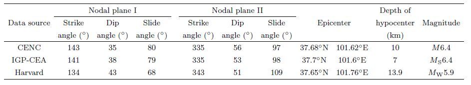
According to the CSN, 888 aftershocks were monitored by 14:24:30 on January 25th, 2016(Fig. 1), and the earthquake was considered as the mainshock-aftershock type. On the ground, the long axis trend of the mainshock and aftershocks was approximately 137°, with a difference of 15° from the Lenglong Ling (trend of 125°) and Minle-Damaying faults (trend of 123°), the closest faults to the epicenter. Clearly, the seismogenic fault of the Menyuan earthquake should not be the two main faults, but other NW faults barely discernible on the surface may very likely be responsible for it (Fig. 1). Additionally, according to the result of precise location of aftershocks by Fang L H et al., the aftershocks were distributed subvertically in the plane perpendicular to the long axis of the aftershock distribution, which did not outline the low dip angle plane of the Minle- Damaying fault. However, it should be also pointed out that the distribution feature obtained by the present precise location of the aftershocks did not actually agree well with the dip angle provided by the mainshock focal mechanism solution.
4 BUILDING DAMAGE AND COLLAPSE-LANDSLIDE FEATURESThe types of earthquake damage include building damage and collapse-landslide damage. According to the damage survey on site, the masonry walls of Shangtiemai village were shattered with falling plaster (Figs. 2a and 2b). Furthermore, the EW fence walls of Shangtiemai village were broken approximately 20 cm above the base, with cracks of approximately 5 cm between the NS fence walls, and sticks were used to keep the walls standing (Fig. 2c). The roofs of Dongtanbeishangen village that were built with tiles were damaged (Fig. 2d), and the main walls of Sujiwan village were shattered in the earthquake, with a crack approximately 3 cm in width (Fig. 2e). At the same time, the original cracks of the house were magnified, and the deformation of the wall could be seen at the frame of the wooden door (Fig. 2f). The main walls of Huaya village were also shattered, with a crack approximately 2 cm in width (Fig. 2g). The house wall of Jugoutai village was also cracked. In the released seismic intensity distribution map, Shangtiemai, Huaya and Quangoutai villages were located in Region VI, and Dongtanbeishangen and Sujiwan villages were located in Region VⅡ. There was much additional building damage, and it could be seen from the above damage analysis that the fence walls were damaged more seriously than the main walls of the houses, the original cracks of the houses were all extended, and the EW fence walls and the transition area between the EW and NS fence walls were seriously damaged. The directivity characteristics of the earthquake damage mentioned above may indicate that the nearly NS ground movements were more intense than the EW movements when the strong vibration occurred, which was consistent with the focal mechanism solution result where the earthquake was almost pure thrust movement. In the meantime, the space distribution of the damages mentioned above is such that the direction of the long axis was NW, which is consistent with the main trend of Qilian Shan when building damage of similar degrees was connected (Fig. 1). The main trend of the seismogenic fault may be obtained, but the presumption of the explicit seismogenic fault from building damage is entirely impossible. Based on the seismic intensity distribution map released at the same time, the trend of the Lenglong Ling fault was thought to be the main trend of the intensity distribution ring, but further work is needed to make sure that the conclusion for the building damage survey provides multiple solutions.

|
Fig. 2 Photos of building damage |
The other type of earthquake damage was collapse-landslide. The 0.8 m resolution remote sensing image taken in the afternoon of January 21st with High Resolution Satellite 2 was interpreted in detail, and the total interpreted epicentral area was approximately 300 km2. More than 23 collapse-landslides were recognized through the color-difference comparative analysis of pre-earthquake and post-earthquake images. The collapse masses were in sharp contrast with the surrounding snow area (Fig. 3). Point a is approximately 7 km to the southwest of the epicenter, belonging to the southern end of Lenglong Ling ridge, from which the ash black sliding groove from the mountain top could be identified, forming lateral extrusion stripes nearly perpendicular to the sliding direction at the bottom of the landslide. Point b, where deep valleys were formed by river trenching, is approximately 4.8 km to the southeast of the epicenter. The valley slope slid down in the earthquake, and thus the m´elange could be found in the cheuch. Point c is approximately 10 km to the north of the epicenter. The highway was covered by dark gray collapse material, which was in clear contrast with other snow-covered grey sections. The collapse was continuously distributed over five spots, which may be because the extremely steep side slopes (caused by cutting during highway building) became unstable and slide in the earthquake. Point d is approximately 3 km to the northeast of the epicenter. Similar to Point a, the collapse was from the mountain top and collapsed over a larger area. Point e is approximately 7 km NW 10° from the epicenter, at which four collapse-landslides developed from the mountain top to the deep valley. The characteristics of Point f were consistent with those of Point c, which has more artificial factors. Next to Points c and f, the collapse scale of Point g was larger, collapsing from the mountain top to the highway. The collapse-landslide from the mountain top could also be seen at Point h, which was approximately 5 km to the north of the epicenter. Point i, covering a smaller range than any of the above points, was approximately 11 km to the southeast of the epicenter, of which slightly more damage was judged from the image interpretation. Similar to Points c, f and g, Point j was also blocked by the collapsing highway slopes. According to the landscape position of the collapse distribution, the typical collapse-landslide mentioned above can be divided into three types: class Ⅰ(Figs. 3c, 3f, 3j and 3g) is the collapse-landslide of highway slopes, class Ⅱ(Figs. 3a, 3d, 3e, 3h and 3i) is the collapse-landslide of the mountain top, and class Ⅲ(Fig. 3b) is the collapse-landslide of gully walls. Considering other interpreted collapses, the spatial distribution of collapse appeared to have an apparent NS overall extension with a length and width of 20 km and 8 km, respectively. If the human factors were removed, the main distribution trend was NNW. In fact, regardless of whether or not human factors were taken into account, the dominant direction of the overall distribution was clearly NS rather than EW. Then, we may conclude that the more strongly affected area in the earthquake was along the direction of NS; that is to say, from the perspective of the spatial distribution of the collapse-landslide, the EW vibration could be excluded from the seismogenic fault. The seismogenic faults were more likely tightly distributed to the north of the epicenter. It could also be inferred that the northern vibration was stronger than the southern because the former was the relatively free hanging side.

|
Fig. 3 Interpreted collapses and landslides in meizoseismal area |
Through detailed satellite remote sensing image interpretation, the likely seismogenic faults-the Lenglong Ling fault belt (also the nearest fault to the epicenter)-were investigated seismo-geologically. Near Taolachailong, Erdaoshui village, Xianmi town, and Menyuan county, the linear features and the dislocation phenomena of the Lenglong Ling fault belt (101.969623°, 37.481947°, 3527 m) were clear (Fig. 1, Figs. 4c, 4d and 4e). The linear structure included fault trough, fault valley and scarp, etc.(Fig. 4c), where the dislocated rivers developed systematically. Gulches of greater levels were left-laterally dislocated by approximately 930 or 942 m in Fig. 4c, among which the original locations of the gulches were abandoned. The sign of dislocation was that the downstream of the g4 Gulch was wider, but its upstream, connected with the g5 Gulch, clearly exhibited the broken ditch feature. The g5 Gulch developed two stages of alluvial fan where the fault cross-cut. The earlier one (Fan 1) was supposed to be the abandoned fan after the two gulches were captured, where the two developed gullies were left-laterally dislocated by approximately 21 m. Gulches g1, g8 and g9 were left-laterally dislocated by approximately 14.3, 103.5 and 330 m, respectively. The g10 Gulch developed 3 grooves in the right, and each was left-laterally dislocated by approximately 2.3 m, which was very likely to be the horizontal displacement of the latest paleoseismic event. The margin of the gulch was also found to be left-laterally dislocated by approximately 2.4 m in the field investigation (Fig. 4e). However, the faults were found to be of the reverse type in the actual investigation, and the upstream of the river declined (Fig. 4d). Based on the fault section investigation, the tendency of the fault section was N, with a dip angle of approximately 54°, but the upper strata of the fault section were compressively reversed during the latest movements. Summing up the above fault features, the activity of the Lenglong Ling fault was mainly strike-slip, although it had a certain vertical motion component, which differed from the nearly pure thrust fault supported by the focal mechanism solution. In this view, although the earthquake was associated with the Lenglong Ling fault zone, which may be a seismic-controlling structure but apparently not the seismogenic structure, otherwise the earthquake should have a larger strike-slip component.

|
Fig. 4 Characteristics of offsets on Lenglong Ling north side fault and Lenglong Ling fault |
Lenglong Ling fault is located in the south margin of Lenglong Ling ridge. In this article, through high resolution remote sensing image interpretation, active faults were found to be clearly developed in the north of the ridge, temporarily called Lenglong Ling northern fault (Figs. 1, 4a, 4b). In the high-resolution remote sensing image of Fig. 4a, the reversed scarp with the south plane down and the north plane up could clearly be recognized at the hillside, and the gulch could also be observed to be left-laterally dislocated. In Fig. 4b, the gulch shown by dark gray could also be found to be left-laterally dislocated, and the deeper dark gray strip in the fluvioglacial deposits were distributed linearly, which implies the existence of new active faults. The general linear trend of the landform images of the two faults was approximately 139°, which is close to the trend of Nodal Plane Ⅰ, which in turn was provided by the focal mechanism solution and was consistent with the long axis direction of the aftershock distribution. The fault (the Lenglong Ling northern fault) is very likely to be the seismogenic structure if the other mentioned faults are denied. Furthermore, according to the mechanics analysis of strike-slip fault systems (Biddle et al., 1985; Sylvester, 1988), the Lenglong Ling northern fault is actually in the compression-thrust position in the left-lateral system, which is composed of the Tuoleshan northern Fault and the Lenglong Ling fault. Certainly, surface rupture was comparatively interpreted in detail through remote sensing images obtained before and after the earthquake. The existence possibility of surface rupture is extremely low. It remains to be tested whether the Tuoleshan northern fault is a seismogenic fault of irrefutable evidence. Additionally, the fracture surface morphology of the above micro-epicenter relative to the surface fracture plane outlined by the precise location of the aftershock also needs to be tested.
6 DISCUSSION AND CONCLUSIONA three-dimensional integrated topographical and geological profile was plotted for the Lenglong Ling fault along NE35°(Fig. 5). In the profile, the occurrence and activity of the fault were investigated based on the surface geological survey. Regarding the aspect of deep earth research, comprehensive analysis was conducted combining the MT depth sounding section, which was 50 km from the epicenter and through the Gulang Earthquake epicenter (Zhan et al., 2008; Jia et al., 2008; Gao et al., 2011; Zhao et al., 2015). The F3-Lenglong Ling fault belt is a deep and large lithospheric fault. To its northeast are the F6-Minle-Damaying fault belt, the F7-Huangcheng-Shuangta fault, and the F8-Lianhua Shan fault, of which the main body was formed at approximately 3.7 Ma, as well as the F9-Longshou Shan faults which began to extend at approximately 2 Ma (Zheng et al., 2013).

|
Fig. 5 Model of genetic mechanism for 2016 Menyuan MS6.4 earthquake |
The trend (134°~143°) and the dip angle of the nodal plane (35°~43°) provided by the focal mechanism solution were used to draw the deep occurrence of the seismogenic fault, whereas the top occurrence employed the analysis result of the surface remote sensing image, and the middle occurrence used the vertical geometric feature of the precise location of the aftershock.
By integrating the above information, structures from above and below the seismogenic fault could be obtained (Fig. 5), from which we could conclude that this earthquake was the result of the compressional movement that the Tibet plateau thrusted and developed towards the NE.
In 1986, an earthquake of MS6.4 occurred in Menyuan. After the earthquake, Yu et al.(1987) processed the Biandukou-Qingshizui leveling data spanning the entire Lenglong Ling fault belt during three periods: 1971-1979, 1979-1983, and 1983-1986. They found that the region to the south of Ebao subsided before the earthquake, but it uplifted as a whole due to the earthquake according to the data covering the seismic period. This may be because the region was located in the north Qilian fold belt; above 20 km, it developed a relatively soft and high conductivity layer that was inclined to deform as a whole.
After the MS6.4 earthquake in 1986, through years of observation and research, breaks extending discontinuously for 1 km towards NW 60° were found at the southern bank of Heiyinggou, the longest of which was 45 m long, 60 cm wide and 80 cm deep (Dang et al., 1988). Without considering the gravitational causes of the break formation, its serrated form reflected that it was a longitudinal tension crack, which is consistent with the seismogenic mechanism result that the normal fault activity occurred. The intensity distribution of the earthquake in 1986 was in accordance with the NW seismogenic fault gained from the land surface survey. The isoseisms were intense in the north and sparse in the south, which may be related to the SW seismogenic fault plane section (Dang et al., 1988). This time, the earthquake occurred almost in the same place, indicating the extreme complexity of the tectonics in this region.
The above-mentioned focal mechanism solution, aftershock distribution, seismic damage distribution, collapse-landslide distribution, satellite image analysis, field investigation of the distribution and features of regional active faults and analysis of the active properties of all the components of the strike-slip fault system was summarized. After using the above data to determine the seismogenic fault of the Ninglang earthquake in 2012 and the Kangding earthquake in 2014(Hu et al., 2012, 2015) and based on the data now available, it was believed that the seismogenic fault of this earthquake was the Lenglong Ling northern fault between the Lenglong Ling fault and the Minle-Damaying fault and that the rupture from the focal point to the land surface was discontinuous. It could not also be ruled out that the seismogenic fault was a blind reverse fault and not exposed on the surface, similar to the seismogenic fault of the Lushan earthquake in 2013(Xu et al., 2013). The northeastern margin of the Qinghai Tibet Plateau keeps pushing and growing in the NE direction. Using large active tectonics, especially the large strike slip faults, as border faults to divide the first class masses in this region, the Qaidam-Qilian first class mass is surrounded by the Arkin fault, the east Kunlun fault, the seismogenic fault of the Mani earthquake in 1997 and the Hexi corridor zone. The Yutian earthquakes in 2008 and 2014 were closely related to the eastward movement of the Qaidam-Qilian mass, which put the loading effect on the eastern section of the Arkin fault zone and the Hexi corridor. The Menyuan earthquake (2016) may be related to the similar loading effect, but the NW active reverse fault fold system of the east and west of the Qaidam basin and Qilian Shan exist and may reduce the amount of loading effect. This had a limited effect on the Hexi corridor Zone and Liupan mountain where the Menyuan earthquake occurred in the east end. However, under this circumstance, the Menyuan earthquake unexpectedly occurred, so the significance of the Menyuan earthquake is very clear. Because of this, we should pay attention to the possibility of the mass evolving into the main area of strong earthquakes (Xu et al., 2003, 2014 and Hu et al., 2015).
ACKNOWLEDGMENTSThis work was supported by the National Natural Science Foundation of China (41302171,41272233),and aided by the organization and coordination of the earthquake emergency command,we could arrive promptly at the scene to carry out the Menyuan earthquake damage survey and scientific investigation. We hereby express our deep gratitude to the Emergency Rescue Department of the China Earthquake Administration and the Seismological Bureau of Qinghai Province. We also thank the experts for their constructive comments regarding this article; thanks to Prof. Ren Jinwei and Prof. Tian Qinjian for their very valuable advice; thanks to the Center of the Network,CEA,for providing aftershock data. Specially,as earthquake science researchers,we dedicate this article to comforting the compatriots with broken homes and injuries suffered during this earthquake.
| [1] | Biddle K T, Christie-Blick N. 1985. Strike-Slip deformation, Basin Formation, and sedimentation. SEPM Spec. Pub.1. No.37, p.1-34. |
| [2] | Dang G M, Tu D L, Ye J Q, et al. 1988. Seismic damage and intensity distribution of the Menyuan earthquake (M=6.4) in 1986[J]. Northwestern Seismological Journal , 10 (3): 95–97. |
| [3] | Gao R, Wang H Y, Wang C S, et al. 2014. Lithospheric deformation shortening of the Northeastern Tibetan Plateau:Evidence from reprocessing of deep seismic reflection data[J]. Acta Geoscientica Sinica , 32 (5): 513–520. |
| [4] | He W G, Liu B C, Yuan D Y, et al. 2000. Research on slip rates of the Lenglongling active fault zone[J]. Northwestern Seismological Journal , 22 (1): 90–97. |
| [5] | Hu C Z, Chen D, Yang P X, et al. 2015a. Microseismic concentration areas before and after the February 12, 2014 Yutian MS7.3 earthquake and possible implication for earthquake risk zone[J]. Earthquake , 35 (1): 11–16. |
| [6] | Hu C Z, Yang P X, Liang P, et al. 2015b. The Holocene paleoearthquakes on the 2014 Kangding MS6.3 earthquake faults[J]. Chinese Science Bulletin , 60 (23): 2236–2244. |
| [7] | Hu C Z, Yang P X, Xiong R W. 2012. Brief seismotectonic analysis of the June 24, 2012 Ninglang-Yanyuan MS5.7 earthquake[J]. Earthquake , 32 (4): 140–147. |
| [8] | Jia S X, Zhang X K. 2008. Study on the crust phases of deep seismic sounding experiments and fine crust structures in the northeast margin of Tibetan plateau[J]. Chinese J. Geophys. , 51 (5): 1431–1443. |
| [9] | Ma B Q, Li D W. 2008. Stages of the neotectonic movement of the menyuan basin in the middle segment of the Qilian mountains[J]. Journal of Geomechanics, 14 (3): 201–211. |
| [10] | Sylvester A G. 1988. Strike-slip faults[J]. Geological Society of America Bulletin, 100 (11): 1666–1703. |
| [11] | The Geological Institution of CSB, Lanzhou Seismological Institution of CSB. 1993. Qilian Mountain Hexi Corridor Fracture System (in Chinese). Beijing:Seismological Press. |
| [12] | Xu X W, Chen J, Xu C, et al. 2014. Discussion on block kinematic model and future themed areas for earthquake occurrence in the Tibetan Plateau:inspiration from the Ludian and Jinggu earthquakes[J]. Seismology and Geology , 36 (4): 1116–1134. |
| [13] | Xu X W, Tapponnier P, Van Der Woerd J, et al. 2005. Late Quaternary sinistral slip rate along the Altyn Tagh fault and its structural transformation model[J]. Science in China Series D:Earth Sciences, 48 (3): 384–397. |
| [14] | Xu X W, Wen X Z, Han Z J, et al. 2013. Lushan 7.0 earthquake:A blind reserve-fault event[J]. Chin. Sci. Bull, 58 (28): 3437–3443. |
| [15] | Yu J M, Yuan M, Jei B, et al. 1987. A preliminary study on the background of regional deformation of the Menyuan earthquake (M=6.4)[J]. Northwestern Seismological Journal , 9 (4): 84–87. |
| [16] | Zhan Y, Zhao G Z, Wang J J, et al. 2008. Deep electric structure beneath the epicentre of the 1927 Gulang M8 earthquake and its adjacent areas from magnetotelluric sounding[J]. Chinese J. Geophys. , 51 (2): 511–520. |
| [17] | Zhao L Q, Zhan Y, Chen X B, et al. 2015. Deep electrical structure of the central west Qinling orogenic belt and blocks on its either side[J]. Chinese J. Geophys. , 58 (7): 2460–2472. DOI: 10.6038/cjg20150722 |
| [18] | Zheng W J, Zhang P Z, Ge W P, et al. 2013. Late Quaternary slip rate of the South Heli Shan Fault (northern Hexi Corridor, NW China) and its implications for northeastward growth of the Tibetan Plateau[J]. Tectonics, 32 (2): 271–293. DOI: 10.1002/tect.20022 |