 2015, Vol. 58


2. College of Science, Wuhan University of Science and Technology, Wuhan 430081, China
Since the successful launch of the twin GRACE satellites, which is a co-sponsored mission between by US and Germany, on 17 March, 2002, it has enormously improved the underst and ing of many scientific fields concerning geodesy, oceanography, hydrology, glaciology, seismology, and so on. However, the limitations of the GRACE mission have been depressing spatial and temporal resolution of the Earth’s gravitational field recovery, and the major shortcomings are depicted below. Firstly, the “north-south striping error” effect: because the twin GRACE satellites are designed as the collinear formation, it does not excel at gaining the cross-track and radial-track components at one time, but just insufficient gravity information in the along-track direction. Since satellite observations take on the inhomogeneous and anisotropic characteristics and the track structure of the GRACE leader-follower formation is especially sensitive to the longitudinal variations of the gravity field, the accuracy of the Earth’s time-varying gravitational field is highly reduced due to the negative effects of the “north-south striping error”(Swenson and Wahr, 2006; Klees et al., 2008). Secondly, the “aliasing error” effect: because the twin GRACE satellites are flying in an orbital repeat period of 30 days, the temporal resolution of the time-variable gravity field model from GRACE is at best one month. Since the errors in the high-frequency oceanic and atmospheric tides with a period of less than 30 days are incapable of being precisely deducted from monthly GRACE gravity models, the effect of the “aliasing error” will occur due to undersampling(Han et al., 2004; Ray and Luthcke, 2006; Moore and King, 2008; Seo et al., 2008; Gruber et al., 2009).
The effect of the “north-south striping error” is expected to be properly mitigated by means of a combination of various types of satellite observations in the along-track, cross-track and radial-track directions, and the effect of the “aliasing error” is propitious to being becomingly weakened by improving spatial and temporal resolution of gravity information. Thereby, in order to reduce the negative impacts of the “north-south striping error” and “aliasing error” on the accuracy of the Earth’s time-varying gravitational field as far as possible, the studies on finding the optimum satellite gravity formation flight has been attracting a great deal of attentions of the scholars, e.g., Bender et al.(2003), Rummel(2003), Sneeuw et al.(2005), Sharifi et al.(2007), Zheng et al. (2010a/b, 2012b), and so on.(1)The Collinear twin-satellite formation, including the GRACE Follow-On mission (Stephens et al., 2006; Flechtner et al., 2009; Zheng et al., 2009b, 2010c, 2012c, 2014; Loomis et al., 2012), the NGGM(Next-Generation Gravimetry Mission)(Anselmi et al., 2010; Silvestrin et al., 2012; Cesare and Sechi, 2013), etc.;(2)The Pendulum twin-satellite formation, involving the E.MOTION(Earth System Mass Transport Mission)(Gruber, 2010; Gruber et al., 2012; Panet et al., 2013), etc.;(3)The Collinear-Pendulum three-satellite formation, including the GRACE-Pendulum-3S mission(Elsaka et al., 2009);(4)The Collinear three-satellite formation, involving the GRACE-3S mission(Zheng et al., 2009a);(5)The Cartwheel foursatellite formation, consisting of the FSCF(Four-Satellite Cartwheel Formation)mission(Wiese et al., 2009; Zheng et al., 2013), and so on;(6)The four-satellite constellation, containing the two pairs of GRACE-type satellites with distinct inclinations(Bender et al., 2008; Zheng et al., 2008; Wiese et al., 2012), and so on.
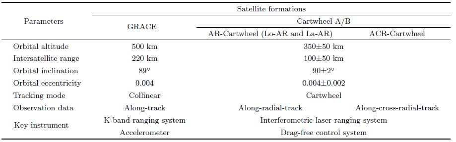
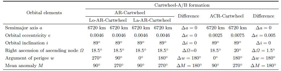
Massonnet(1998)first applied the cartwheel satellite formation mode to the interferometric measurement of the passive radar. Sneeuw and Schaub(2004)brought forward a new idea regarding the precise monitor of the Earth’s gravitational field by the cartwheel satellite formation system. Wiese et al.(2009) and Zheng et al.(2013)accurately and rapidly calculated the Earth’s gravitational field based on the cartwheel four-satellite formation. Sneeuw and Schaub(2005)carried out the feasibility studies on improving resolution of gravity field estimation by the cartwheel six-satellite formation. As shown in Table 1, the future twin Cartwheel-A/B satellites which expectably adopt a formation architecture consisting of a cartwheel satellite pair intend to operate at an almost-circular, near-polar and low-Earth orbit. The low-orbiting Cartwheel-A/B satellite is continuously tracked by an orbital determination precision of better than 10-2 m based on the high-orbiting Global Navigation Satellite System(GNSS)(e.g., GPS, GLONASS, Galileo, Compass, etc.), the intersatellite range-rate with an accuracy of 10-7 ~ 10-9 m·s-1 is monitored by the Interferometric Laser Ranging(ILR) system, and the non-conservative force is compensated by a measurement precision of 10-11 ~ 10-13 m·s-2 using the Drag-Free Control System(DFCS). Relative to the GRACE collinear formation, the benefits to the future Cartwheel-A/B twin-satellite formation are listed as follows. Firstly, the along-track, cross-track and radialtrack gravity signals can be simultaneously attained by the Cartwheel formation. Hereby, spatial resolution of the gravity field solutions is able to be greatly increased depending on the homogeneous and isotropic satellite observations. Secondly, the isotropic gravity information makes for weakening the “north-south striping error”. Thirdly, the interferometric laser ranging system is favorable to enhancing the precision of the intersatellite range-rate measurements by 1~3 orders of magnitude, which aims to debase the negative affects of observation errors on the accuracy of satellite gravity recovery. The drag-free control system is good at eliminating the adverse impacts of the non-conservative force on the operational lifetime of the satellite, which hammers at efficiently restraining the signal attenuation of gravity field by flying at a lower orbital altitude of 300~400 km. Finally, compared with the Cartwheel four-satellite formation flight, the virtues of the Cartwheel twin-satellite formation are principally composed of the slight technical difficulty, the low research expenditure, and so on.
| Table 1 A comparison of satellite formations between present GRACE and future Cartwheel-A/B |
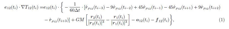
The satellite gravity recovery methods chiefly consist of the dynamics method, the energy conservation principle, the satellite acceleration approach and the short-arc integral method. The advantage of the dynamics method(Zhou, 2005; Zhang, 2007)shows that the recovery accuracy of the Earth’s gravitational field is relatively high, and the disadvantage represents that the model errors are improved with the increase of the orbital arc length. The strongpoint of the energy conservation principle(Cheng and Xu, 2006; Zheng et al., 2006)denotes that the Earth gravity field model is propitious to being easily produced owing to the linear relationship of satellite observation equations between the spherical harmonic coefficients of the geopotential and the disturbing potential of the Earth, and the shortcoming displays that the influences of satellite observation errors including orbital position and velocity, intersatellite range-rate and nonconservative forces on the accuracy of Earth’s gravitational field are mixed with each other. The virtue of the satellite acceleration approach(Shen et al., 2005; Zheng et al., 2011)indicates that the computational complexity is low and the expression of observation equation is simple, and the defect is that the accuracy of the Earth’s low-frequency gravitational field is decreased due to adopting the numerical differential principle. Elsaka(2010)carried out the demonstration researches in terms of the radial and inclined Cartwheel two-satellite formation based on the short-arc integral method. The advantage of the short-arc integral method is that the calculating speed is rapid and computational process is simple as compared with the dynamics method, and the disadvantage is that the measurement accuracy of the Earth’s long-wavelength-b and gravitational field is low on account of a shorter orbital arc of about 30 minutes(Mayer-Gürr, 2006). Because different methods of the satellite gravity recovery are sensitive to distinct frequency spectrums of the Earth’s gravitational field, the major purpose of this study is to develop the availability argumentations regarding how to improve the spatial resolution of the gravity information relying on the future ACR-cartwheel twin-satellite formation based on the six-point intersatellite range-rate interpolation method.
2 INTERSATELLITE RANGE-RATE INTERPOLATION APPROACHThe observation equation of the six-point intersatellite range-rate interpolation is expressed as(Zheng et al., 2012a)
The Earth’s geopotential coefficients degree Root-Mean-Square(RMS)errors are represented as

The cumulative geoid height errors are defined as

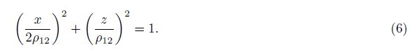
The ratio between semi-major axis ρmax and semi-minor axis ρmin for the relative elliptical motion of the AR-Cartwheel twin-satellite formation is equivalent to ρmax : ρmin = 2 : 1, and the measurements in the alongtrack and radial-track directions can be synchronously achieved. The orbital eccentricity e = $\frac{{{\rho }_{\max }}}{4a}=\frac{{{\rho }_{\min }}}{2a}$ is a crucial orbital element to set the ratio of semi-major and semi-minor axes, where a is the distance from the satellite to the geocenter. The space between the apogee of one satellite and the perigee of the other is equal to the larger distance of the twin satellites in the radial direction, and the maximum distance of the twin satellites in the along-track direction is twice longer than the minimum distance in the radial direction(Schaub and Junkins, 2003). The AR-Cartwheel twin-satellite formation mainly consists of the Lo-AR-Cartwheel twinsatellite formation(Fig. 1) and the La-AR-Cartwheel twin-satellite formation(Fig. 2). As denoted in Figs. 1-3, O-XYZ indicates the Earth-Centered Inertial(ECI)coordinate frame, the origin O is located at the centroid of the Earth, OX-axis is oriented along the mean equinox, OZ-axis points in direction of the North Pole of the Earth, and OY-axis forms a right-handed triad with OX-axis and OZ-axis. o-xyz represents the Orbit Coordinate System(OCS), the origin o lies in the satellite’s center of mass, ox-axis is directed to the orbital motion of the satellite(along-track), oy-axis is perpendicular to the orbital plane(cross-track), and oz-axis points to the radial direction away from the geocenter(radial-track).

|
Fig.1 Measurement principle of the twin Lo-ARCartwheel-A/B satellites formation |

|
Fig.2 Measurement principle of the twin La-ARCartwheel-A/B satellites formation |
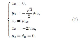
The initial motion conditions of the AR-Cartwheel twin-satellite formation are expressed as(Elsaka, 2010):
The relative elliptical equation of motion from the AR-Cartwheel formation is defined as
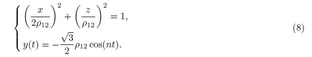
As indicated in Fig. 3, the future ACR-Cartwheel twin-satellite formation skills in simultaneously acquiring the along-track, cross-track and radial-track satellite observations. The initial motion conditions of the ACR-Cartwheel twin-satellite formation are expressed as(Elsaka, 2010)

|
Fig.3 Measurement principle of the twin ACRCartwheel-A/B satellites formation |
The relative elliptical motion equation of the ACR-Cartwheel formation is represented as
This study numerically computed the ephemeris of the twin Cartwheel-A/B satellites by combining the Runge-Kutta linear single-step with the 12th-order Adams-Cowell linear multi-step integral formulas(Liu, 1992), the Keplerian orbital parameters are listed in Table 2, and the priori Earth gravity field model EGM2008 is truncated at degree and order 120.
| Table 2 Keplerian orbital elements of the Cartwheel-A/B twin-satellite formation |
According as the Gauss-Markov model, the colored noises of the observational data are defined as(Shen, 2000)
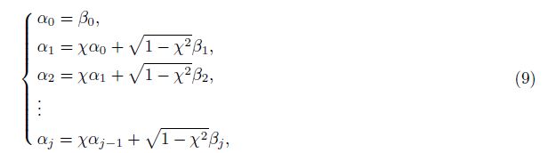
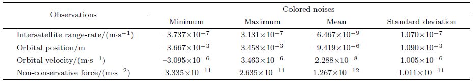
We simulated the colored noises of satellite observations consisting of intersatellite range, orbital position, orbital velocity and non-conservative force by the Gauss-Markov model using a sampling interval of 10 s and the correlation coefficients(e.g., 0.85 in intersatellite range of the interferometric laser ranging system, 0.95 in orbital position and orbital velocity of the GPS receiver, and 0.90 in non-conservative force of the accelerometer) in this study, where the colored noise of intersatellite range, and the colored noises in the X-axial direction from orbital position, orbital velocity and non-conservative force are illustrated in Fig. 4, and the statistical results are denoted in Table 3.

|
Fig.4 Colored noises of intersatellite range-rate, orbital position, orbital velocity and non-conservative force |
| Table 3 Statistical results of colored noises from Cartwheel-A/B satellite observations |
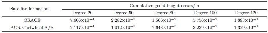
As indicated in Fig. 5, the asterisk line denotes the real precision of the Earth gravity field model EIGENGRACE02S released by the GFZ, and the cumulative geoid height error is 1.893×10⁻¹ m at degree 120. The solid line represents the simulation accuracies of the Earth’s gravitational field from ACR-Cartwheel-A/B complete up to degree and order 120 based on the intersatellite range-rate interpolation method using the GRACE orbital parameters(e.g., orbital altitude of 500 km, intersatellite range of 220 km, orbital inclination of 89° and orbital eccentricity of 0.001) and the measurement precision of GRACE payload instruments(e.g., intersatellite range-rate of 10-6 m·s-1, orbital position of 10-2 m, orbital velocity of 10-5 m·s-1 and non-conservative force of 10-10 m·s-2), the 30-day observational data and a sampling interval of 10 s, respectively. The cumulative geoid height error from ACR-Cartwheel-A/B is 1.329×10⁻¹ m at degree 120, and the statistical results are indicated in Table 4. The study results show that based on the identical orbital parameters of the satellite and the measurement precision of the space-based equipments from GRACE, the average accuracy of satellite gravity recovery from the future ACR-Cartwheel-A/B twin-satellite formation is about 2.6 times higher than that from the current GRACE collinear formation. The main reasons are illuminated as follows.

|
Fig.5 A comparison of cumulative geoid height errors between GRACE and ACR-Cartwheel-A/B twin-satellite formations |
| Table 4 Statistical results of cumulative geoid height errors from GRACE and ACR-Cartwheel-A/B |
Firstly, the GRACE collinear formation can solely measure the along-track signals of gravity field, but is unable to acquire measurements in the cross-track and radial-track directions at the same time. Consequently, the accuracy of the Earth’s static and time-varying gravitational field from GRACE will be impaired to a great extent as a result of the “north-south striping errors” effect.
Secondly, gravity information in the along-track, cross-track and radial-track directions is capable to be conveniently derived from the future ACR-Cartwheel-A/B twin-satellite formation.(1)Owing to additionally gaining the cross-track and radial-track components relative to the existing GRACE mission, the recovery accuracy of the Earth’s gravitational field from ACR-Cartwheel-A/B is conducive to being further improved.(2) The negative influences of the north-south striping errors on global time-variable gravity signals will be weakened on account of the homogenous and isotropic measurements from the twin ACR-Cartwheel-A/B satellites.
In short, the future ACR-Cartwheel-A/B twin-satellite formation promisingly precedes the present GRACE collinear formation in terms of reducing “north-south striping errors”.
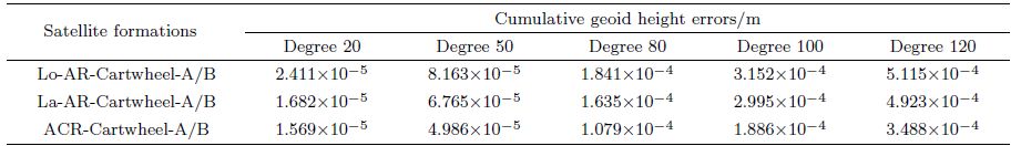
4.2.2 Accuracy comparison between AR-Cartwheel and ACR-CartwheelAs expressed in Fig. 6, the dashed, solid, cross lines, respectively, represent the simulation accuracies of the Earth’s gravitational field determination from Lo-AR-Cartwheel-A/B, La-AR-Cartwheel-A/B and ACRCartwheel-A/B complete up to degree and order 120 by the intersatellite range-rate interpolation method, using satellite orbital parameters(Table 2) and the measurement precision of spaceborne sensors(Table 3), based on a time span of 30 days and a sampling interval of 10 s. The cumulative geoid height errors are 5.115×10⁻⁴ m, 4.923×10⁻⁴ m and 3.488×10⁻⁴ m at degree 120, and the statistical results are given in Table 5. The investigation results are manifested as follows.

|
Fig.6 A comparison of cumulative geoid height errors based on Lo-AR-Cartwheel-A/B, La-AR-Cartwheel-A/B and ACR-Cartwheel-A/B twin-satellite formations |
| Table 5 Statistics of cumulative geoid height errors from different types of Cartwheel satellite formations |
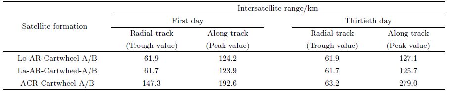
Firstly, the cumulative geoid height error from La-AR-Cartwheel-A/B has an average reduction of 20% than that from Lo-AR-Cartwheel-A/B. The specific reasons are analyzed as follows: Figs. 7 and 8 illustrate the variational tendencies of the intersatellite range measurements from the Lo-AR-Cartwheel-A/B and La-ARCartwheel-A/B formations in a month, respectively. Table 6 lists the peak and trough values of the intersatellite range measurements from the Lo-AR-Cartwheel-A/B and La-AR-Cartwheel-A/B twin-satellite formations in the first and thirtieth days, where the peak value(maximum)is the along-track intersatellite range and the trough value(minimum)is the intersatellite range of the radial-track direction. In the first day, the along-track and radial-track intersatellite range measurements from the La-AR-Cartwheel-A/B formation are as completely stable as the Lo-AR-Cartwheel-A/B formation with the identical periodic fluctuations. In the thirtieth day, the radial-track intersatellite range measurements from the Lo-AR-Cartwheel-A/B and La-AR-Cartwheel-A/B formations still maintain the steady fluctuations relative to the first day. However, the along-track intersatellite range(2.9 km)from the Lo-AR-Cartwheel-A/B formation is drifted larger than that(1.8 km)from the La-AR-Cartwheel-A/B formation. The main reasons are presented as follows: because the maximum intersatellite range in the along-track direction from the Lo-AR-Cartwheel-A/B formation is located in the areas near Earth’s equator, the drift of the along-track intersatellite range will gradually become larger owing to the disturbance of the Earth’s oblateness J2. In a word, since the formation stability of the twin La-AR-Cartwheel-A/B satellites overmatches that of the twin Lo-AR-Cartwheel-A/B satellites, the accuracy of satellite gravity recovery from the La-AR-Cartwheel-A/B formation is higher than that from the Lo-AR-Cartwheel-A/B formation.

|
Fig.7 Intersatellite range of the Lo-AR-Cartwheel-A/B satellite formation |

|
Fig.8 Intersatellite range of the La-AR-Cartwheel-A/B satellite formation |
| Table 6 A comparison of intersatellite ranges from Lo-AR-Cartwheel-A/B, La-AR-Cartwheel-A/B and ACR-Cartwheel-A/B twin-satellite formations in the first and thirtieth days |
Secondly, in the long-wavelength b and of the Earth’s gravitational field, the cumulative geoid height error from the La-AR-Cartwheel-A/B formation is markedly lower than that from the Lo-AR-Cartwheel-A/B formation. However, with the increasing of the spherical harmonic function of degree, the accuracy differences of satellite gravity recovery between the La-AR-Cartwheel-A/B and Lo-AR-Cartwheel-A/B formations become inapparent little by little. The primary causes are stated as follows: the twin GRACE satellites which employ the collinear tracking mode merely are able to provide a single gravity signal component in the along-track direction, and are chiefly sensitive to the medium-long-wavelength signals of gravity field. Hence, the alongtrack measurements have a great contribution to improving the accuracy of the medium-long-wavelength gravity field recovery. Due to a significant drift of the along-track intersatellite range from the Lo-AR-Cartwheel-A/B formation, the determination accuracy of the Earth’s medium-long-wavelength gravitational field from the Lo-AR-Cartwheel-A/B formation is evidently lower than the La-AR-Cartwheel-A/B formation. However, since the recovery capability of the along-track observations will be inch by inch trailed off with the gradual increase of spherical harmonic degree, the accuracy difference of satellite gravity recovery between the Lo-AR-Cartwheel-A/B and La-AR-Cartwheel-A/B formations will get unobvious by degrees.
Finally, the accuracies of the Earth’s gravitational field measurement based on the future ACR-Cartwheel-A/B twin-satellite formation are averagely increased by 60% and 35% compared with the Lo-AR-Cartwheel-A/B and La-AR-Cartwheel-A/B formations, respectively. The dominating reasons are depicted as follows: because the Lo-AR-Cartwheel-A/B and La-AR-Cartwheel-A/B formations merely may take the along-track and radialtrack gravity information, the accuracy of the Earth’s gravitational field will be dropped on account of lacking the cross-track component. However, since the future ACR-Cartwheel-A/B twin-satellite formation is propitious to synchronously attaining gravity signals in three different directions consisting of along-track, cross-track and radial-track, the accuracy of the Earth’s gravitational field is hopeful to be substantially improved by the homogeneous and isotropic observational data.
To sum up, the future ACR-Cartwheel-A/B twin-satellite formation is an optimal option for precisely establishing the Earth gravity field model with higher spatial resolution.
5 CONCLUSIONSBecause the design defects(e.g., the orbital altitude could not be substantially decreased, the measurement accuracy of spaceborne instrumentations is unable to be awfully significantly improved, and the isotropic gravity information is incapable of being simultaneously acquired, etc.)of the present twin GRACE satellites have resulted in poor spatial and temporal resolution of the Earth’s gravitational field, this paper aims at carrying through the exploratory investigations on optimizing spatial resolution by the future ACR-Cartwheel-A/B twinsatellites formation. The specific conclusions are summarized as follows.
Firstly, we surveyed the Earth’s gravitational field complete up to degree and order 120 by the future ACR-Cartwheel-A/B twin-satellite formation using the satellite orbital parameters and the measuring accuracy of pivotal apparatuses from GRACE. The research results suggest that the recovery accuracy of the Earth’s gravitational field from the future ACR-Cartwheel-A/B twin-satellite formation clearly surpasses that from the existing GRACE collinear formation since the twin ACR-Cartwheel-A/B satellites could attain observational data in more than one direction.
Secondly, we compared the accuracies of the Earth’s gravitational field from Lo-AR-Cartwheel-A/B, La-AR-Cartwheel-A/B and ACR-Cartwheel-A/B complete up to degree and order 120. The research results are described as follows.(1)The accuracy of satellite gravity recovery by the La-AR-Cartwheel-A/B formation exceeds that by the Lo-AR-Cartwheel-A/B formation.(2)With the increase of degree, the predominance of the along-track measurements to recover the medium-long-wavelength gravity field will gradually disappear. Therefore, the capabilities of respectively mapping the Earth’s gravitational field by the Lo-AR-Cartwheel-A/B and La-AR-Cartwheel-A/B formations will tend to be consistent.(3)The future ACR-Cartwheel-A/B twin-satellite formation has the potential to detect the high-accuracy and high-resolution Earth’s gravitational field.
ACKNOWLEDGMENTSWe greatly appreciate the helpful suggestions from editors and anonymous reviewers. This work was supported by the Main Direction Program of Knowledge Innovation of Chinese Academy of Sciences for Distinguished Young Scholar(KZCX2-EW-QN114), the National Natural Science Foundation of China(41004006, 41131067 and 11173049), the Merit-based Scientific Research Foundation of the State Ministry of Human Resources and Social Security of China for Returned Overseas Chinese Scholars(2011), the Open Research Fund Program of the Key Laboratory of Geospace Environment and Geodesy, Ministry of Education, China(11-01-02), the Open Research Fund Program of the Key Laboratory of Geo-Informatics of National Administration of Surveying, Mapping and Geoinformation of China(201322), the Open Research Fund Program of the State Key Laboratory of Geo-information Engineering, China(SKLGIE2013-M-1-5), the Main Direction Program of Institute of Geodesy and Geophysics, Chinese Academy of Sciences(Y309451045), the Research Fund Program of State Key Laboratory of Geodesy and Earth’s Dynamics, China(Y309491050), the Research Fund of the National Civilian Space Infrastructure Project(2014), and the Research Fund of the Lu Jiaxi Young Talent and the Youth Innovation Promotion Association of Chinese Academy of Science(2013).
| [1] | Anselmi A,Cesare S,Cavaglia R.2010.Assessment of a next generation mission for monitoring the variations of Earth's gravity.ESA Contract 22643/09/NL/AF,Final Report,Issue 2,22 Dec. |
| [2] | Bender P L,Nerem R S,Wahr J M.2003.Possible future use of laser gravity gradiometers.Space Science Reviews,108(1-2):385-392. |
| [3] | Bender P L,Wiese D N,Nerem R S.2008.A possible dual-GRACE mission with 90 degree and 63 degree inclination orbits.//Pro-123 Design Considerations for A Dedicated Gravity 97 Proceedings of the Third International Symposium on Formation Flying,Missions and Technologies.ESA/ESTEC,Noordwijk,1-6. |
| [4] | Cesare S,Sechi G.2013.Next generation gravity mission.//D'Errico M ed.Distributed Space Missions for Earth System Monitoring.Space Technology Library Volume 31,575-598. |
| [5] | Cheng L Y,Xu H Z.2006.The rotation of the gravity potential on the Earth's gravity field recovery.Chinese J.Geophys.(in Chinese),49(1):93-98. |
| [6] | Elsaka B,Ilk K H,Kusche J.2009.Simulated multiple formation flights for future gravity field recovery.//Poster in European Geosciences Union(EGU),General Assembly,Vienna,Austria. |
| [7] | Elsaka B.2010.Simulated satellite formation flights for detecting the temporal variations of the Earth's gravity field[Ph.D.thesis].Bonn:University of Bonn. |
| [8] | Flechtner F,Neumayer K H,Doll B,et al.2009.GRAF-A GRACE follow-on mission feasibility study.Geophysical Research Abstracts,Vol.11,EGU,8516. |
| [9] | Gruber Th,Peters Th,Zenner L.2009.The role of the atmosphere for satellite gravity field missions.//Sideris M G ed.Observing Our Changing Earth.International Association of Geodesy Symposia Volume 133,105-112. |
| [10] | Gruber Th.2010.E.motion-A proposal for a future satellite mission for the determination of the time-variable Earth gravity field.GRACE Science Team Meeting,Potsdam,11. |
| [11] | Gruber Th,Panet I,Johannessen J,et al.2012.Earth system mass transport mission(e.motion):technological and mission configuration challenges.//International Symposium on Gravity,Geoid and Height Systems,GGHS2012,Venice,9-12. |
| [12] | Han S C,Jekeli C,Shum C K.2004.Time-variable aliasing effects of ocean tides,atmosphere,and continental water mass on monthly mean GRACE gravity field.Journal of Geophysical Research,109(B4),doi:10.1029/2003JB002501. |
| [13] | Kim J.2000.Simulation study of a low-low satellite-to-satellite tracking mission[Ph.D.thesis].Austin:University of Texas. |
| [14] | Klees R,Revtova E A,Gunter B C,et al.2008.The design of an optimal filter for monthly GRACE gravity models.Geophysical Journal International,175(2):417-432. |
| [15] | Liu L.1992.Orbital Mechanics of Artificial Earth Satellites(in Chinese).Beijing:Higher Education Press,1-619. |
| [16] | Loomis B D,Nerem R S,Luthcke S B.2012.Simulation study of a follow-on gravity mission to GRACE.Journal of Geodesy,86(5):319-335. |
| [17] | Massonnet D.1998.Roue interfrometrique.French patent no 339920D17306RS. |
| [18] | Mayer-Gürr T.2006.Gravitationsfeldbestimmung aus der Analyse kurzer Bahnbogen am Beispiel der Satellitenmissionen CHAMP und GRACE[Ph.D.thesis].Bonn:University of Bonn. |
| [19] | Moore P,KingMA.2008.Antarctic ice mass balance estimates from GRACE:tidal aliasing effects.Journal of Geophysical Research,113(F2),doi:10.1029/2007JF000871. |
| [20] | Panet I,Flury J,Biancale R,et al.2013.Earth system mass transport mission(e.motion):a concept for future Earth gravity field measurements from space.Surveys in Geophysics,34:141-163. |
| [21] | Petit G,Luzum B.2010.IERS Conventions(2010).IERS Technical Note 36,Verlag des Bundesamts für Kartographie und Geod-sie,Frankfurt am Main,Germany. |
| [22] | Ray R D,Luthcke S B.2006.Tide model errors and GRACE gravimetry:towards a more realistic assessment.Geophysical Journal International,167(3):1055-1059. |
| [23] | Roesset P J.2003.A simulation study of the use of accelerometer data in the GRACE mission[Ph.D.thesis].Austin:University of Texas,1-253. |
| [24] | Rummel R.2003.How to climb the gravity wall.Space Science Reviews,108(1-2):1-14. |
| [25] | Schaub H,Junkins J L.2003.Analytical Mechanics of Space Systems.Reston,VA:AIAA Education Series. |
| [26] | Seo K W,Wilson C R.,Chen J L,et al.2008.GRACE's spatial aliasing error.Geophysical Journal International,172(1):41-48. |
| [27] | Sharifi M A,Sneeuw N,Keller W.2007.Gravity recovery capability of four generic satellite formations.//Kilicoglu A,forsberg R,eds.Gravity Field of the Earth.General Command of Mapping,ISSN 1300-5790,Special issue 18,211-216. |
| [28] | Shen Y Z.2000.Study of recovering gravitational potential model from the ephemerides of CHAMP[Ph.D.thesis](in Chinese).Wuhan:Institute of Geodesy and Geophysics,Chinese Academy of Sciences,1-111. |
| [29] | Shen Y Z,Xu H Z,Wu B.2005.Simulation of recovery of the geopotential model based on intersatellite acceleration data in the low-low satellite to satellite tracking gravity mission.Chinese J.Geophys.(in Chinese),48(4):807-811. |
| [30] | Silvestrin P,Aguirre M,Massotti L,et al.2012.The future of the satellite gravimetry after the GOCE mission.//Kenyon S,Pacino M C,Marti U,eds.Geodesy for Planet Earth.International Association of Geodesy Symposia Volume 136,223-230. |
| [31] | Sneeuw N,Schaub H.2004.Satellite clusters for future gravity field missions.//IAG International Symposium,Gravity,Geoid,and Space Missions,Porto,Portugal. |
| [32] | Sneeuw N,Flury J,Rummel R.2005.Science requirements on future missions and simulated mission scenarios.Earth Moon Planets,94(1-2):113-142. |
| [33] | Sneeuw N,Schaub H.2005.Satellite clusters for future gravity field missions.//Jekeli C,Ba-stos L,Fernandes J,eds.Gravity,Geoid and Space Missions.International Association of Geodesy Symposia Vol.129.Berlin Heidelberg:Springer,12-17. |
| [34] | Stephens M,Craig R,Leitch J,et al.2006.Demonstration of an interferometric laser ranging system for a follow-on gravity mission to GRACE.//Proceedings of IEEE International Conference on Geoscience and Remote Sensing Symposium.Denver,CO:IEEE,1115-1118. |
| [35] | Swenson S,Wahr J.2006.Post-processing removal of correlated errors in GRACE data.Geophysical Research Letters,33(8):L08402,doi:10.1029/2005GL025285. |
| [36] | Wiese D N,Folkner W M,Nerem R S.2009.Alternative mission architectures for a gravity recovery satellite Mission.Journal of Geodesy,83(6):569-581. |
| [37] | Wiese D N,Nerem R S,Lemoine F G.2012.Design considerations for a dedicated gravity recovery satellite mission consisting of two pairs of satellites.Journal of Geodesy,86(2):81-98. |
| [38] | Zhang H W,Xu H Z,Wang A S.2004.Tidal wave formulas of solid tide on the temporal changes of gravitational field.Acta Geodaetica et Cartographica Sinica(in Chinese),33(4):299-302. |
| [39] | Zhang X F.2007.The Earth's field model recovery on the basis of satellite-to-satellite tracking missions[Ph.D.thesis](in Chinese).Shanghai:Tongji University,1-120. |
| [40] | Zheng W,Shao C G,Luo J,et al.2006.Numerical simulation of Earth's gravitational field recovery from SST based on the energy conservation principle.Chinese J.Geophys.(in Chinese),49(3):712-717. |
| [41] | Zheng W,Shao C G,Luo J,et al.2008.Improving the accuracy of GRACE Earth's gravitational field using the combination of different inclinations.Progress in Natural Science,18(5):555-561. |
| [42] | Zheng W,Xu H Z,Zhong M,et al.2009a.Physical explanation of influence of twin and three satellite formation mode on the accuracy of Earth's gravitational field.Chinese Physics Letters,26(2):029101-1-029101-4. |
| [43] | Zheng W,Xu H Z,Zhong M,et al.2009b.Accurate and rapid error estimation on global gravitational field from current GRACE and future GRACE Follow-On missions.Chinese Physics B,18(8):3597-3604. |
| [44] | Zheng W,Xu H Z,Zhong M,et al.2010a.Research progress in international gravity satellites and future satellite gravity measurement program in China.Science of Surveying and Mapping(in Chinese),35(1):5-9. |
| [45] | Zheng W,Xu H Z,Zhong M,et al.2010b.Research on optimal selection of orbital parameters in the Improved-GRACE satellite gravity measurement mission.Journal of Geodesy and Geodynamics(in Chinese),30(2):43-48. |
| [46] | Zheng W,HSU H T,Zhong M,et al.2010c.Efficient and rapid estimation of the accuracy of future GRACE Follow-On Earth's gravitational field using the analytic method.Chinese J.Geophys.(in Chinese),53(4):796-806,doi:10.3969/j.issn.0001-5733.2010.04.004. |
| [47] | Zheng W,Xu H Z,Zhong M,et al.2011.Accurate and fast measurement of GRACE Earth's gravitational field using the intersatellite range-acceleration method.Progress in Geophysics(in Chinese),26(2):416-423,doi:10.3969/j.issn.1004-2903.2011.02.003. |
| [48] | Zheng W,Hsu H T,Zhong M,et al.2012.Precise recovery of the Earth's gravitational field with GRACE:Intersatellite Range-Rate Interpolation Approach.IEEE Geoscience and Remote Sensing Letters,9(3):422-426. |
| [49] | Zheng W,Xu H Z,Zhong M,et al.2012a.Progress in international next-generation satellite gravity measurement missions.Journal of Geodesy and Geodynamics(in Chinese),32(3):152-159. |
| [50] | Zheng W,Hsu H T,Zhong M,et al.2012b.Impacts of interpolation formula,correlation coefficient and sampling interval on the accuracy of GRACE Follow-On intersatellite range-acceleration.Chinese J.Geophys.(in Chinese),55(3):822-832,doi:10.6038/j.issn.0001-5733.2012.03.012. |
| [51] | Zheng W,Hsu H T,Zhong M,et al.2013.Precise and rapid recovery of the Earth's gravitational field by the next-generation four-satellite cartwheel formation system.Chinese J.Geophys.(in Chinese),56(9):2928-2935,doi:10.6038/cjg20130907. |
| [52] | Zheng W,Hsu H T,Zhong M,et al.2014.Precise and rapid recovery of the Earth's gravity field from the next-generation GRACE Follow-On mission using the residual intersatellite range-rate method.Chinese J.Geophys.(in Chinese),57(1):31-41,doi:10.6038/cjg20140104. |
| [53] | Zhou X H.2005.Research on satellite gravity and its application[Ph.D.thesis](in Chinese).Wuhan:Institute of Geodesy and Geophysics,Chinese Academy of Sciences,1-138. |