 2015, Vol. 58


2. Funciton Laboratory for Marine Mineral Resource Geology and Exploration, Qingdao National Oceanography Laboratory, Qingdao 266000, China;
3. Qingdao Institute of Marine Geology, Qingdao 266071, China
Located in the eastern Yangtze paraplatform, the South Yellow Sea area is the seaward extension of the lower Yangtze block, of which the South Yellow Sea basin is the primary portion. Through geological and geophysical surveys as well as comparative research with adjacent regions in the last several decades, geologists have reached consensus on tectonic and sedimentary evolution of this basin. After consolidation and inversionfolding during the Jinning movement in the late Proterozoic, the South Yellow Sea area has experienced a series of tectonic processes such as sedimentation on a stable platform, block convergence, oscillation compression, collision orogeny, transform from compression to extension and faulting-depression subsidence. Afterwards a multi-cycle composite basin developed on the double-layer basement made up of folded metamorphic crystalline rock of the middle Proterozoic and epimetamorphic rock of the late Proterozoic(Chen et al., 1999; Wan, 2004). From the Sinian to the middle and late Triassic period, stable tectonic movement characterized the South Yellow Sea, which received a set of platform sediment formation dominated by marine carbonate, forming a marine middle-Paleozoic basin. In the Indosinian epoch, the Yangtze block collided with the North China block, leading to whole uplift of the South Yellow Sea basin, where uplifted folds were eroded resulting in the sedimentary basement of the subsequent continental Mesozoic and Cenozoic basins. Since the late Cretaceous, the South Yellow Sea manifested extensional faulting depression, forming continental fault-depression basins. From the Neogene, tectonic movement in this area tended to be gentle, entering the stage of basin depression. The current widely adopted tectonic units in this area were demarcated based on the distribution of the upper Cretaceous-Eogene strata(Yin et al., 2010; Hou et al., 2012)(Fig. 1). Due to uplift and reform by the Indosinian and Yanshanian tectonic movements, the middle Paleozoic marine basin was buried beneath the later basin, thus was called the residual basin(Liu, 1997; 1999; 2001). The Indosinian, Yanshanian, and Cenozoic tectonic movements have also complicated the basement of the Mesozoic and Cenozoic continental basin in this region. Especially in the uplifted portions of the basin, whether the strata beneath the Neogene are metamorphic rock, Mesozoic volcanic rock, or sedimentary rock of the Paleozoic remain controversial because of lacking drilling data(Hao et al., 2002; Feng et al., 2002; Chen et al., 2003, Li et al., 2003; Zhang, 2009). In previous studies, the discussions about thickness and distribution of the Mesozoic succession in the South Yellow Sea basin focused on the depression in the north(Li et al., 2004), while the basement relief of the continental basin and marine stratum distribution in the whole South Yellow Sea are not clear, which limits the progress of oil and gas assessment in this region.

|
Fig.1 Map showing tectonic units of the Cenozoic basin and locations of seismic lines and boreholes in the South Yellow Sea basin. Black box is the study area |
In recent years, toward the marine residual basin of the Mesozoic and Paleozoic in the South Yellow Sea, which is the new area of oil and gas exploration, a batch of high-precision multiple-channel seismic, gravity and magnetic survey data have been acquired(Fig. 1). By special data processing, for the first time the internal reflection of the Mesozoic and Paleozoic marine succession on the sections of some survey lines were obtained(Zhang et al., 2009; Wang et al, 2010; Ou, 2009; Wu, 2011; Lin, 2012). Based on these new data, coupled with previous studies, we establish the sedimentary sequence of the South Yellow Sea. Using the regional angular unconformity that formed during the Jinningian and Indosinian movements as the boundary, the unmetamorphed sedimentary rocks in this area are divided into two big tectonic structural layers. Of them, the upper one consists of the Mesozoic and Cenozoic continental strata and the lower layer comprises the marine carbonate rock cover from the Sinian to middle and lower Triassic(Qinglong limestone). This work uses newly acquired geophysical data and integration method of geology and geophysics to analyze the basement constitution of the Cenozoic basin and depth of the crystalline basement, and residual of the Meso-Paleozoic marine sediments in the South Yellow Sea, which provides basic information for oil and gas assessment in this area.
2 BASEMENT OF THE CONTINENTAL MESOZOIC-CENOZOIC BASINResearch shows that the basement of the Subei(North Jiangsu)basin on the l and , which connects with the South Yellow Sea basin, has complex rock composition. It has three primary types:(1)metamorphic rock of the middle Proterozoic;(2)marine sedimentary rock of the middle Paleozoic or of middle and upper Triassic in the(lower)Yangtze platform; and (3)marine-continent transition and continent clastic rock and medium-acid volcanic rock of the lower Cretaceous(Yang et al., 2003). Comparative study on the l and and sea indicates that the portion of the Subei-South Yellow Sea basin in the sea area is similar to that on l and , and the basement of the Meso-Cenozoic continental basin is also characterized by highly variable burial depth and complicated litholgic composition. In the past, with few geophysical data available, geophysicists used the gravity inversion method to calculate the basement depth with constraints of seismic and drilling data, in light of the fact that local Bouguer gravity anomalies correspond well to uplift and depression of the Meso-Cenozoic basin in this region(Dai et al., 2011; Huang et al., 2010). However, measured gravity anomalies are the combined effects of heterogeneous distribution of subsurface density, difficulties of anomaly extraction and density determination make the inversion results usually not so reliable. Thus the basement derived from gravity inversion is actually the gravity basement rather than the acoustic basement. Although such a gravity basement can roughly delineate the relief of the Meso-Cenozoic continental basement, which cannot reveal its lithologic composition; neither provide information on erosion of the Mesozoic and Paleozoic marine basin.
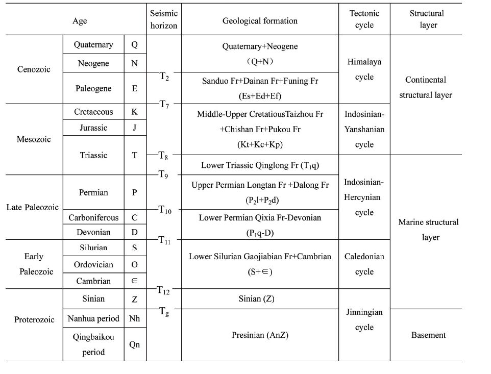
So far, the drilling boreholes in the South Yellow Sea have not yet revealed the lower Paleozoic succession. Of them, in seven wells, continental sedimentary rocks of the Mesozoic and Cenozoic were penetrated, and the Paleozoic strata were encountered which involves the lower Triassic Qinglong formation of limestone to the Carboniferous Gaolishan formation(Dai, 2011). In recent years, with assessment of oil and gas resources of the Meso-Paleozoic marine strata in the South Yellow Sea, a large amount of seismic data have been collected. During interpretation of these data, the drilling wells aforementioned are the main basis for determining the horizons of Mesozoic and underlying Paleozoic strata. Also with reference to previous results of seismic and geologic research in the South Yellow Sea as well as geological data from the Subei basin, the geological interfaces corresponding to the st and ard seismic reflection layers were determined. Meanwhile in conjunction with features of gravity and magnetic anomalies, 2.5D joint inversion of gravity, magnetism and seismology were performed on typical profiles to recognize stratum attributes and structural features(Yang et al., 2008; Hou et al., 2012). Finally, integrating the information from geologic and geophysical data permitted to establish seismic-geologic horizons(Table 1, Fig. 2 and Fig. 3).
| Table 1 Tection evolution stages and stratigraphic sequences of the South Yellow Sea basin |

|
Fig.2 Interpretation of part of seismic profile XQ07-7 in the South Yellow Sea |

|
Fig.3 Interpretation of part of seismic profile XQ07-10 in the South Yellow Sea |
The Indosinian interface(T8)is the unconformity between the basins of two periods from reformation of the Meso-Paleozoic marine sedimentary layers by the Indosinian movement. It is the reflection from the top of the Qinglong formation in the lower Triassic as well as the acoustic base of the Meso-Cenozoic continental basin. It is not only a seismic acoustic impedance interface, but also an important density interface. As a regional characteristic seismic wave group, T8 manifests usually 1 or 2 strong phases in seismic profiles, with medium-high continuity, big amplitude, and low frequency. Its lower portion exhibits disconformity contact and the upper portion as super-contact, which can be traced and compared continuously in the region(Fig. 2). While in the uplifted area of the basin, the reflection wave group of the basement probably reflects a seismic impedance interface in the upper Paleozoic strata or some layers of the lower Paleozoic(Fig. 3), or the pre-Sinian metamorphic rocks. Based on a wealth of seismic data and our comprehensive interpretations, we made maps of basement burial depth and lithology composition of the Meso-Cenozoic basin in this area(Fig. 4 and Fig. 5).

|
Fig.4 Depth contours of the top of Mesozoic-Paleozoic marine strata in the South Yellow Sea(Red lines outline depressions) |

|
Fig.5 Formation lithology of the basement of the Mesozoic-Cenozoic continental basin in the South Yellow Sea |
In combination with maps of basement burial depth and formation lithology for the continental Mesozoic-Cenozoic basin in the South Yellow Sea, we infer that the basement structure is of a nearly EW trending pattern with “three lows and two highs” or “three concaves and two convexes”. It is relatively deeper in the north and shallower in the south. In the northern basin, the Qianliyan uplift has a basement of pre-Sinian metamorphic rocks, while the acoustic basement of the depression is 1~6 km deep. The three deep sinks of the basement correspond to the three sags of the Meso-Cenozoic basin. Most of the basement strata are the upper Paleozoic P1-D. Due to incomplete preservation, some are speculated to be the Silurian-Cambrian strata. The Qinglong limestone of lower Triassic and the Longtan formation of the upper Permian are little in the northern depression, only few residuals are preserved in the east. Probably the residual Sinian-lower Permian is relatively broadly distributed in this region. In the central uplift, there is almost no residual Longtan coal-bearing formation and Dalong formation of the upper Paleozoic and Qinglong limestone. While in the southern depression, except major uplifted areas, these strata are all widely presented, which are 24~1840 m thick as revealed by many drilling wells(wells W5-ST1, W4-2-1, CZ35-2-1, and CZ4-1-1). Based on features of the acoustic basement of the Mesozoic and Cenozoic continental facies basin, we infer that the Sinian-lower Permian strata should be widely distributed in the South Yellow Sea basin.
3 FEATURES OF THE PERMIAN AND TRIASSIC SYSTEM DISTRIBUTIONAlthough the newly collected seismic data on some survey lines have revealed the inner reflections of the marine lower Paleozoic System, their amount is limited. In terms of current reliable seismic and drilling data available, only the base of the Qinglong formation and Longtan formation show reliable seismic reflective markers for industrialized mapping of the Meso-Paleozoic marine strata in the South Yellow Sea basin(Dai, 2011). The reasons for this include complex geologic conditions, large burial depth, especially the lower Paleozoic strata in the two depressions weaken seismic reflective energy. In contrast, in the central uplift, the Neogene overlies directly upon the Permian(or Carboniferous)carbonate rocks, forming a strong reflective interface with reflective coefficients up to 0.3~0.5 which can highly shield downward propagation of seismic signals, making little energy of seismic waves reach to the underlying strata(Wu et al., 2011). In recent years, offshore experiments and efforts for technological breakthrough in seismic data acquisition have been conducted in the South Yellow Sea, especially in the central uplift of the basin. Nevertheless, the seismic reflection layer of the Mecozoic-Paleozoic marine strata is still unable to be traced continuously in the entire region. From reported results, the current study on distribution of lower Paleozoic strata is confined to the central uplift(Wang et al., 2010; Ou et al., 2009), and remains largely speculative. Some researchers have tried to estimate thickness and distribution of these strata using gravity and magnetic methods(Huang, 2010, Zhang et al., 2007). However, due to lack of constraints on inversion from drilling and seismic data, those inversion results are still largely conjectural. Therefore, this work attempted to use the currently available data to make a thicknesses map of the Longtan formation and Dalong formation as well as the Triassic Qinglong limestone in the southern depression of the South Yellow Sea basin(Fig. 6 and Fig. 7).

|
Fig.6 Residual thickness of the upper Permian in the southern South Yellow Sea basin |

|
Fig.7 Residual thickness of the middle and lower Triassic in the southern South Yellow Sea basin |
According to the distribution of the upper Paleozoic(Longtan coal measures+Dalong formation) and the Mesozoic Qinglong formation of limestone, the South Yellow Sea basin can be divided into two regions, i.e. the southern depression in the north and the Wunansha uplift in the south. The upper Permian Longtan coal-measures and Dalong formation as well as the lower Triassic Qinglong limestone have similarities in their distribution and trends, but differ much in their residual thicknesses. In the southern depression, the residual upper Permian marine strata have two deposition centers, where the thicknesses change little, ranging 500 m to 1000 m with maximum about 1000 m. And their structure strikes in NW direction. To the south, the Wunansha uplift trends in NE, generally with thicknesses 500 m to 900 m and the maximum residual thickness of 1000 m close to well CZ35-2-1. In the southern depression, the residual Mesozoic Qinglong formation of limestone presents a structural framework of two sags and one rise trending in NW and nearly EW with over 1000 m residual thickness and maximum 4000 m. Due to the influence of the Indosinian and Yanshanian movements, this stratum has been locally denuded up at many places within the sags.
4 CRYSTALLINE BASEMENT OF THE MARINE MESOZOIC AND PALEOZOIC SYSTEMComparative study shows that the lithology and sedimentary evolution during Meso-Paleozoic marine deposition periods in the Sichuan basin of the upper Yangtze bear a resemblance to that of the South Yellow Sea basin in the lower Yangtze(Qi et al., 2013). This is also true in their basements that developed upon ancient continental nucleus(Sun, 1985; Chen et al., 1988; Dai, 2003)with double-layer structure. The Yangtze continental nucleus formed in the late Archaeozoic(earlier than 2500 Ma), becoming initial continental massif by accretion in the early Proterozoic(2500~1800 Ma). The ancient continental nucleuses in central Sichuan and Subei-South Yellow Sea had experienced break up in the middle Proterozoic(1800~1000 Ma). During the Jinningian movement in the middle Proterozoic(about 1000 Ma), the assemblage of the Yangtze and South China blocks led to formation of a unified ancient continent(Zhou et al., 2007). In the Yangtze massif, below the unconformity generated by the main episode of the Jinningian movement, the basement of the late Proterozoic and Paleozoic basin comprised complex rocks that had experienced intensive regional metamorphism, folding, and magma intrusion(Shan, 1993). Based on geological data from l and , previous work suggested that the characteristic positive magnetic anomalies of central Sichuan and South Yellow Sea were caused by interediate-basic, basic-ultrabasic, and intermediate complex and varied hypometamorphic rocks of the early Proterozoic and late Archaeozoic that have strong magnetism. These rocks constitute the old nucleus of the original basement of the Yangtze block, in which the diamond-shaped crystalline complex is surrounded by epimetamorphic sedimentary rock, which has weak magnetism. From geologic data on l and , the magnetic anomalies in this area are considered to be produced by the buried basement rocks of the Yangpo, Kongling, Dabie, and Jushan groups. It is usually thought that the old rigid massif was the nucleus of an old plate, which served as a stable central zone and kept stable during the subsequent tectonic movements(Zhang et al., 2006). Because the basement of such Mesozoic and Paleozoic marine basins is deeply buried, it is difficult to probe by the seismic method. For example, in the South Yellow Sea, only drilling in the Huang 2 well in the northern depression reached the Sinian epimetamorphic rock(Cai, 2002; Liu, 1983). Therefore, geophysicists usually use magnetic data to estimate the depth of the basin basement upon such an ancient continental block(Huang et al., 2010; Zhang et al., 2007; Cao, 1988; Jiang et al., 2001; Guo, 2005). Volcanic rocks are prevailing along the rim of the South Yellow Sea, of which the effect is difficult to remove completely from the total magnetic anomalies only using filtering. In contrast, the magnetic field within the South Yellow Sea basin is broad and gentle, where little Mesozoic and Cenozoic volcanic rocks are present. In the background of gentle negative anomalies, the magnetic anomalies in this area are dominated by intermediate- and long-wavelength components. Its center is a block-like positive magnetic field. There are four block-shaped high-anomaly contour closures with intervening low-negative anomaly closures. These anomalies have small gradients, and the range of positive values is larger than that of negative values(Fig. 8). Bounded by 122°E, the trending directions of anomalies in east and west differ much.

|
Fig.8 Reduction to the pole magnetic anomaly map of the South Yellow Sea basin and adjacent areas(Red rectangle is the study area) |
Based on magnetic anomalies in the South Yellow Sea basin and surroundings and geology of the Subei basin on l and , we infer that the block-like anomalies in the central South Yellow Sea should be caused by an ancient continental nucleus. Likely it reflects the highly magnetic Jushan group of the Archaeozoic to early Proterozoic forms the main portion of the basement of the South Yellow Sea basin. Negative anomalies of - 100~-50 nT surrounding the central area of the South Yellow Sea basin presumably represent the basement with relatively weak metamorphism. Based on those assumptions, we calculated the depth of the crystalline basement using magnetic data. The basement relief and structural trends display correlation with the magnetic anomalies. Several massive magnetic anomalies in the central basin imply a shallow buried basement that becomes deeper toward surroundings. The trends of contours of basement’s burial depth exhibit three directions: NE, EW, and NW. Of them, the NW trending contours correspond to the uplifted basement, while those in EW and NE directions are consistent with basement’s depressions. The depth of the crystalline basement ranges from 4 km to 12 km with an average about 8 km(Fig. 9).

|
Fig.9 Contours of basemen depth in the South Yellow Sea basin |
Comparison of the crystalline basement and continental Mesozoic-Cenozoic basin basement shows both similarities and differences. In both basements, most the uplifted portions lie in the middle of the basin, i.e. the central uplift of the Cenozoic basin. In the northern basin, about one third of the acoustic basement sag of the continental basin coincides with the crystalline basement uplift zone. While in the south, the uplift area of the continental basin is located in the crystalline basement slope which becomes gradually deeper from south to north. The structural lines of the two basements also have distinctive features. In the central area, the highest portions of the NW-trending uplifted crystalline basement coincide with two NW-trending depressions on the basement uplift of the continental basin, presenting a mirror-image relation. Within the basin, the area with large burial depth of the crystalline basement does not correspond to the depositional centers of the Himalayan period in both the northern and southern depressions, where the average burial depth of the crystalline basement exceeds 9 km, or more in the northern depression with maximum depth 12 km. To the south, the Wunansha uplift also has a deep basement which turns shallower toward south.
As the burial depth of the Meso-Paleozoic marine sedimentary basement is unknown, we cannot calculate accurately the thickness of the residual Meso-Cenozoic marine sediments. But we can describe the rough preservation of these strata through calculating the thickness between the crystalline basement and the top of the Mesozoic and Paleozoic marine layers(Fig. 10).

|
Fig.10 Contours of stratum thickness between the top of the Mesozoic-Paleozoic strata and crystalline basement in the South Yellow Sea basin |
It can be seen that the distribution of the Meso-Paleozoic and upper Proterozoic strata as well as structural trends are controlled by the relief of the crystalline basement. In conjunction with seismic data aforementioned, we infer that the marine Meso-Paleozoic strata should be widely present in the South Yellow Sea basin, which are preserved to varied degrees dependent on places, likely associated with different evolution processes there. Compared to the two Mesozoic and Cenozoic depressions in the north and south, the thickness of the residual marine strata in the central uplift is relatively stable. Such thickness is larger in the depressed crystalline basement. The adjoining area between the Wunansha uplift and southern depression is a center of residual marine Mesozoic and Paleozoic, where its thickness is likely up to 10 km. To the northwest, another center of residual marine strata may be 9 km thick or more. Such thickness is relatively smaller in the uplifted crystalline basement, which changes gently, implying a stable rim of the ancient continental nucleus. Overall, north-south block division and east-west zonation characterize the marine Mesozoic and Paleozoic strata in the South Yellow Sea basin. The NE-NNE directed structures stretch around N30°E with intervening sags and rises. The NEE-nearly EW trending structure is crossed by a NE-NNE structure. It is commonly thought that the NE-NNE directed structures in eastern mainl and China developed during the late Indosinian to the early Yanshanian period in response to the subduction of the Pacific plate beneath the Eurasia plate, which exerted a counterclockwise shear in NS direction upon the crust in eastern China. Apparently, the NE-NNE trending structure has controlled the residual pattern of the Longtan formation of upper Permian-Qinglong formation of lower Triassic in the South Yellow Sea basin.
5 CONCLUSIONS(1)Outcrops, drilling data and geophysical data show that in the South Yellow Sea and surroundings there exist strata and rocks of each epoch at least since the late Archaeozoic. They have distinct features of formation, metamorphism and deformation, and suffered from different levels of erosion. Multiphase tectonic movements had occurred in this area since the late Archaeozoic, resulting in varied structural features from the crystalline basement, Meso-Cenozoic continental basement to sedimentary cover. Laterally, north-south block division and east-west zonation characterize the basic tectonic pattern, while the occurrence times of main tectonic events of every tectonic unit are largely comparable.
(2)In the South Yellow Sea, the relief of Meso-Cenozoic continental basin basement, i.e. the top of the Meso-Paleozoic marine strata, is well correlated with Bouguer gravity anomalies, being the most important density interface of this area. The burial depth of the continental basin basement is relatively large in the north depression, with big thickness of continental strata. This basement can be roughly divided into two sedimentary facies regions in north and south. In the north, most rocks of the basin basement are the lower Permian, while limestone of the Qinglong formation dominates the southern depression.
(3)Except the missing at major uplifted portions of southern depression, the Longtan coal-measures and Qinglong limestone are widely present. In the South Yellow Sea basin, the NE-NNE trending structures apparently control the residual pattern of distribution of the two strata above.
(4)Magnetic and seismic data suggest that the Mesozoic and Paleozoic marine strata in the central uplift of the South Yellow Sea basin are more stable and have less deformation than that in the north and south. However, this central uplift is an inherit structure, which kept its uplift state during the sedimentation periods at the end of Caledonia, Indosinian, and Tertiary. The uplifting during Caledonia caused the strata of early Paleozoic to be denuded remarkably. During the Indosinian period, the central part of the basin uplifted intensively, leading to almost complete erosion of the overlying Longtan formation and Qinglong formation, even partial the Devonian to lower Permian succession. Nevertheless, there are still several thous and meters of Mesozoic and Paleozoic marine strata left there.
(5)Overall, a pattern of north-south block division and east-west zonation characterizes the Meso-Paleozoic marine strata in the South Yellow Sea, which is a composite structure of nearly EW trending and NE-NEE directed structures. From features of the two basements of the basin, its structural lines extend in regional directions. The NE-NEE trending structures are mainly present in the northern depression. The nearly EW striking structures are distributed in the central uplift. And the nearly NS directed structures are seen in the southern depression. The NE and EW trending structures outline the whole basin. The Indosinian movement not only shaped the Meso-Cenozoic continental basin, but also posed significant influence on reform of the Meso-Paleozoic marine strata in this area.
(6)The current available data do not allow us to determine accurately the burial depth of Mesozoic and Paleozoic succession, neither the situation of residual strata beneath the lower Permian in the South Yellow Sea.
ACKNOWLEDGMENTSWe thank Profs. Guo Zhenxuan, Lei Shoumin and Dai Chunshan for their guidance in interpretation of seismic data, tectonic evolution, and applying integrated geophysical data to geologic problems. We are grateful to Drs. Zhang Minghua and Yao Changli for their enlightened discussion with us. Our thanks are also extended to the two reviewers for their suggestive comments. This work was supported by the Special Project of Geological Surveys of the Ministry of National L and s and Resources of China(GZH200900504, GZH200800503), and the National Natural Science Foundation of China(41210005, 41206050).
| [1] | Cai Q Z. 2002. Regional geology and geotectonic environment of petroliferous basins in the Yellow Sea. Marine Geology Letter (in Chinese), 18(11):8-12. |
| [2] | Cao S H. 1988. Application of aeromagnetic anomalies in the basement character study of Sichuan Basin and the reginal tectonic features of Sichuan Province. Acta Geological Sichuan (in Chinese), (2):1-9. |
| [3] | Chen H J, Qiu Z J. 1988. Comparative petroleum geological study between middle Yangtze area and upper and lower Yangtze areas. Experimental Petroleum Geology (in Chinese), 10(4):305-314. |
| [4] | Chen H S, Zhang Y H, Xu S W, et al. 1999. The Lithospheric Textural and Structural Features as Well as Oil and Gas Evaluation in the Lower Yangtze Area and Its Adjacent Region, China (in Chinese). Beijing:Geological Publishing House. |
| [5] | Chen J W, Xiao G L, Liu S Q, et al. 2003. Strategy of oil and gas resources explorations in China seas. Marine Geology & Quaternary Geology (in Chinese), 23(4):77-82. |
| [6] | Dai C S. 2011. Oil Gas Basin Group of China Seas and Early Resource Assessment Techniques (in Chinese). Beijing:Ocean Press. |
| [7] | Dai C S, Li G, Cai F, et al. 2003. The pretertiary and its hydrocarbon exploration targets in Yellow Sea. China Offshore Oil and Gas (Geology) (in Chinese), 17(4):225-231. |
| [8] | Feng Z Q, Yao Y J, Zeng X H, et al. 2002. The new understanding on Mesozoic-Paleozoic structural feature and hydrocarbon prospect in the Yellow Sea. Marine Geology Letters (in Chinese), 18(11):17-20. |
| [9] | Guo T L. 2005. Regional magnetic anomalies and basement characteristics of Lower Yangtze Area. Journal of Oil and Gas Technology (JJPI) (in Chinese), 27(3):329-333. |
| [10] | Hao T Y, Mancheol S, Wang Q S, et al. 2002. A study on the extension of fault zones in Yellow Sea and its adjacent areas based on gravity data. Chinese Journal of Geophysics (in Chinese), 45(3):385-397. |
| [11] | Hou F H, Tian Z X, Zhang X H, et al. 2012. Joint inversion of gravity, magnetic and seismic data of the South Yellow Sea Basin. Oil Geophysical Prospecting (in Chinese), 47(5):808-814. |
| [12] | Huang S, Hao T Y, Xu Y, et al. 2010. Study on macro distribution of residual basin of south Yellow Sea. Chinese J.Geophys. (in Chinese), 53(6):1344-1353. |
| [13] | Jiang W W, Liu Y K, Hao T Y, et al. 2001. Comprehensive study of geology and geophysics of Sichuan basin. Progress in Geophysics (in Chinese), 16(1):11-23. |
| [14] | Li G, Chen J W, Xiao G L, et al. 2003. Petroleum prospect of marine Paleozoic in the South Yellow Sea. Marine Geology Letters (in Chinese), 19(8):12-16. |
| [15] | Li G, Zhang Y, Chen J W, et al. 2004. Seismic reflection characteristics and selection of hydrocarbon prospective areas in the Terrestrial Mesozoic strata of the Yellow Sea. Periodical of Ocean University of China (in Chinese), 34(6):1069-1074. |
| [16] | Lin N T, Gao D H, Sun J, et al. 2012. Seismic attributes of the Permian and Triassic in Qingdao depression, South Yellow Sea Basin and their geological significance. Acta Petrolei Sinica (in Chinese), 33(6):987-995. |
| [17] | Liu G. 1987. Basement structure and tectonic evolution of the Middle Yangtze area. Journal of Jianghan Petroleum Institute (in Chinese), 9(2):6-13. |
| [18] | Liu G D. 1997. Preliminary discussion on residual basins. Petroleum Explorationist (in Chinese), 2(3):1-4. |
| [19] | Liu G D. 2001. Pre-Cenozoic marine residual basins. Progress in Geophysics (in Chinese), 16(2):1-7. |
| [20] | Liu G D, Song H B, Zhang F Q. 1999. A preliminary study of Chinese offshore pre-cenozoic residual basins. Progress in Geophysics (in Chinese), 14(3):1-8. |
| [21] | Liu X L. 1983. Discussion on the boundaries and tectonic evolution of the Yangtze paraplatform in the South Yellow Sea. Marine Geology & Quaternary Geology (in Chinese), 3(2):63-77. |
| [22] | Ouyang K, Zhang X H, Li G. 2009. Characteristics of stratigraphic distribution in the middle uplift of South Yellow Sea.Marine Geology & Quaternary Geology (in Chinese), 29(1):59-66. |
| [23] | Qi J H, Wen Z H, Zhang X H, et al. 2013. Lithostratigraphic correlation of Mesozoic and Palaeozoic marine strata between south Yellow Sea and upper Yangtze region. Marine Geology & Quaternary Geology (in Chinese), 33(1):109-119. |
| [24] | Shan X L. 1993. On the property of the basement formation in the paleozoic basins of the Yangtze area. Experimental Petroleum Geology (in Chinese), 15(4):370-384. |
| [25] | Sun H Z. 1985. The evolution of basement of the Yangzi faulting block. Scientia Geologica Sinica (in Chinese), (4):334-341. |
| [26] | Wan T F. 2004. An Outline in Tectonic of China (in Chinese). Beijing:Geological Publishing House. |
| [27] | Wang F, Li H J, Zhang Y G. 2010. Stratigraphic geologic attribute and hydrocarbon geology in Laoshan uplift of South Yellow Sea. Marine Geology & Quaternary Geology (in Chinese), 30(2):95-102. |
| [28] | Wu Z Q, Wu S G, Tong S Y, et a1. 2004. A study on seismic acquisition basic on marine carbonate hydrocarbon exploration in the southern Yellow Sea. Chinese J. Geophys. (in Chinese), 54(4):1061-1074. |
| [29] | Yang J Y, Wu Z Q, Yao C L. 2008. Application of 2.5 gravity, magnetic and seismic joint inversion to the geological study in the south Yellow Sea. Marine Geology Letters (in Chinese), 24(8):33-38. |
| [30] | Yang Q, Chen H Y. 2003. Tectonic evolution of the north Jiangsu-south Yellow Sea basin. Petroleum Geology & Experiment (in Chinese), 25(S1):562-565. |
| [31] | Yin Y H, Wen Z H. 2010. Regional Tectonic Map (in Chinese).//Zhang H T, Zhang X H, Wen Z H, et al. Map Series of Geology and Geophysics of Eastern China Seas and Adjacent Regions (1:12015010800). Beijing:Ocean Publishing House. |
| [32] | Zhang H, Zhou L Q, Li J Q. 2006. Hydrocarbon exploration potential analysis of the lower marine formation assemblage in the lower Yangtze region. Petroleum Geology & Experiment (in Chinese), 28(1):15-20. |
| [33] | Zhang H Q, Chen J W, Li G, et al. 2009. Discovery from seismic survey in Laoshan uplift of the south Yellow Sea and the significance. Marine Geology & Quaternary Geology (in Chinese), 29(3):107-113. |
| [34] | Zhang M H, Xu D S, Chen J W. 2007. Geological structure of the yellow sea area from regional gravity and magnetic interpretation. Applied Geophysics, 4(2):75-83. |
| [35] | Zhou X J, Yang F. 2007. Tectonic evolution and prototypes analysis from neoproterozoic to early Paleozoic in South China. Petroleum Geology & Experiment (in Chinese), 29(5):446-451. |