 2015, Vol. 58


2. Key Laboratory of Airborne Geophysics and Remote Sensing Geology, Ministry of Land and Resources, Beijing 100083, China
The study of magnetic anomalies is based on different magnetic properties of rocks. The sedimentary cover can be regarded as non-magnetic rock, compared with the metamorphosed and magmatic-reformed Precambrian basement and intruded magmatic rock. Therefore, magnetic anomalies are related with the relief of Precambrian basement and intrusion(collectively called magnetic basement). The basement depth can be calculated using aeromagnetic anomalies, which permits preparation of a magnetic basement depth map. According to such a map, one can further study the characteristics of basement depth and thickness of sedimentary cover and the range of uplift and depression, which are significant for oil and gas exploration.
The China Aero Geophysical Survey Remote Sensing Center for L and and Resource(AGRS)has successively performed aeromagnetic surveys at varied scales and successively completed compilation of magnetic basement depth maps for 31 basins and districts since the 1980s(Fig. 1). These maps were inconvenient in the research of Chinese continent magnetic basement structure because they were compiled at different times, using different scales and coordinate systems, and usually for subareas or blocks. Therefore, we recompiled a map through variety of techniques in a unified manner. During the compiling, the existing magnetic basement depth maps of different regions were unified into the same scale and spliced in the same coordinate system. In the blank areas, the basement depth was calculated or interpolated using aeromagnetic anomalies. According to the above magnetic basement depth values, combining with the magnetic anomalies and geological characteristics, the magnetic basement depth map for China mainland was prepared. This map has a certain accuracy and reliability as proved by seismic and drilling tests, and would provide evidence for geological study and energy and resource prospecting.

|
Fig.1 Sketch map showing mapping degrees of China mainland magnetic basement depth |
The compilation of the magnetic basement depth map used the data digitized from the maps of 31 basins and districts which were accomplished by AGRS during 1981 to 2010(Fig. 1). The coordinate systems of these maps were transformed from Cartesian coordinates into Lambert conformal conic projection coordinates(central meridian: 105°000', double st and ard latitude: 47°, 25°, origin latitude: 18°). The scales were unified into 1:1201501060. The supplementary depths were calculated from aeromagnetic measurement profiles for the areas without magnetic basement depth data available. Integrating these data, the magnetic basement depth map of China mainland was compiled in a unified way.
2.1 Methodology of Magnetic Basement Depth CalculationThe magnetic basement depth calculation is essentially to invert the depth of the top of a magnetic body based on magnetic anomalies. There are various kinds of methods for such calculation, which can be simply divided into two categories: manual calculation and computer automatic inversion. These methods have their own limitations because of the complex geological conditions and multiplicity of inversion interpretation. This situation can be effectively improved through integrating various methods to h and le different magnetic anomalies. In this study, we primarily used the tangent method and Vacquier method, and also the △T horizontal gradient curve method, four-point method, three-dimensional empirical formula and Euler deconvolution method(Vacquier et al., 1963; Zhu, 1975, 2012; Cai and Li, 1977; Tan and Guo, 1984; Guan, 2005; Marello et al., 2010; Liu, 2013).
It should be noted that when we estimate the depth to the top of the magnetic body, the origins of magnetic anomalies are highly variable because of the complex geological settings in each tectonic area. They include wide and gentle magnetic anomalies produced by basements, local magnetic anomalies by sediments and magmatic rocks, and interference anomalies by buildings on the surface. These magnetic anomalies overlap and interfere with each other. Therefore, to accurately calculate the depth value of a magnetic basement must apply various data synthetically and rely on the interpreters' experience. For instance, magnetic anomalies could be used to estimate the depth after eliminating the undesired anomalies when there are obvious regional magnetic anomalies in the area. In volcanic areas, the magnetic anomalies are generally of high intensity and irregular, which seriously disturb the regional anomalies and are difficult to eliminate. In this situation, prior to the estimate of magnetic body depth using the magnetic anomalies, low-pass filtering should be made. The choice of filtering parameters depends on the shape and scale of volcanic rock. Magnetic anomalies often have a steep wing and a gentle wing when crossing two tectonic units. The steep wing indicates the uplift of the basement or intrusion while the gentle wing reflects the depression of the basement. This kind of anomalies is usually divided into two parts and calculated respectively. If one wing suffers serious interference, the calculation is operated on another wing by using the Vacquier method. Generally, the estimate of depth should choose a reasonable method to eliminate undesired anomalies according to the shape of magnetic anomalies.
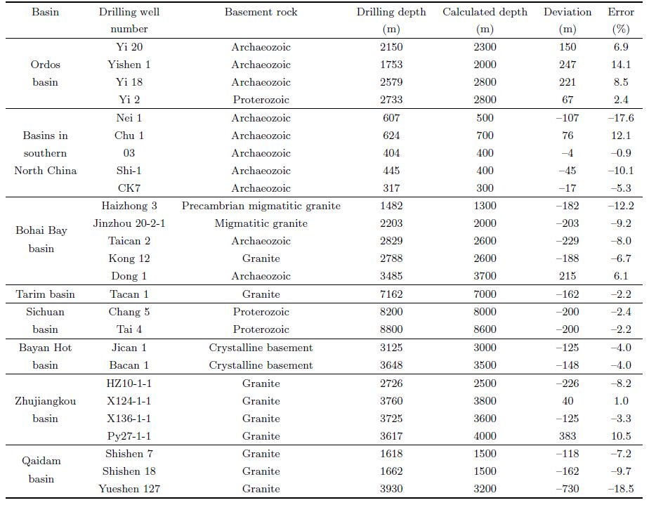
2.2 Precision of CalculationThe precision of different methods used to calculate the depth of a basement determines the reliability of the map compiled. Comparing the depth values from 26 drilling boreholes that exposed Precambrian metamorphic rocks with the depth values estimated by using the magnetic anomalies(Table 1), the error less than ±10% accounts for 73%, and between ±10% and ±20% for 27%, which indicates the results have fairly high precision. For example, the wells Chang 5 and Tai 4 in Luzhou and Chishui southeast of Sichuan encountered Proterozoic metamorphic basement at depths 8200 m and 8800 m, respectively. The depths calculated using aeromagnetic anomalies by the Vacquier method are 8000 m and 8600 m respectively(Fig. 2).
| Table 1 Comparison of Precambrian metamorphosed basement and granite depth revealed by drilling wells and by calculation in Chinese basins |

|
Fig.2 Comparison of Precambrian rock depth revealed by drilling data and calculation based on aeromagnetic data in Sichuan basin |
Obviously, the results are close to the real depths. Both wells show wide and slowly rising magnetic anomalies with values 10 to 20 nT. Rock magnetic data indicate that the Proterozoic metamorphic basement of the Sichuan basin has magnetism and its magnetic susceptibility is(60~1080)×10-5 SI. However, the sedimentary cover is non-magnetic. Therefore, the wide and slow anomalies indeed reflect the Proterozoic metamorphic basement of this area.
2.3 Factors Affecting Depth CalculationUsing data only from 26 wells data to calculate depth of magnetic basement in China mainland is not adequate to represent the precision of all calculated results. These results may be deeper or shallower than the real depth in different areas. The main reasons are presented below.
(1)When the depth of a three-dimensional(3D)body is calculated by the method for a two-dimensional(2D)body, the resultant depth would be lower. Because the coefficient for depth calculation is deduced from a 2D body model. From the aeromagnetic anomaly map, some anomalies should be caused by 3D bodies. If the formula of the 2D body is applied mechanically to the 3D, the results would have errors and the calculated depth must be lower. Besides, the geometric model for the 2D body is the simplest 2D infinite thick plate, but extension of any magnetic body is finite. Therefore, using the infinite model will lead to shallow depth calculated.
(2)The magnetic anomalies overlapped and interfered with each other make the calculated depth smaller. When two magnetic bodies are close, their generated anomalies show mutual interference. In this case, the depth calculated with these anomalies will make the results shallower.
(3)Aeromagnetic survey lines are generally perpendicular to the main tectonic line in the working area, While local structures are not concerned. When the survey line is not orthogonal to the local structure, two wings of magnetic anomalies become gentle that makes the calculated depth larger.
(4)The effect of flight height. In calculating the depth of a magnetic body, one should subtract the flight height which is an average value of the whole area. Actually, the flight height is not identical, so subtracting average height could cause a certain error.
In above four situations, overlapped anomalies are difficult to separate and cause the maximum error. The flight height error can pose influence on shallowly buried magnetic bodies, thus its overall effect is the least. Although those magnetic bodies which strike obliquely to survey lines may have shallower depth calculated, they also have minor effect due to less existence in nature. Most of volcanic rocks with strong magnetism are 3D or approximately 2D bodies, which can not meet the model requirement “downward infinite extension of a 2D body”. Mechanically using a 2D model tends to result in a smaller depth. Long-term theoretical research and practical work indicate that the errors of the tangent method and Vcaquier method range from ±10% to ±20%, which do not affect the accuracy of compiling 1:1201501060 maps.
2.4 Mapping Method of Magnetic Basement DepthCompilation of magnetic basement depth map was based on about 120000 depth data. All depth values were reviewed to ensure the quality of the map. As an example, we illustrated the method taken in compilation of the magnetic basement depth map for the southern Sichuan basin.
First, the depth values calculated from original profiles were marked on the survey lines(Fig. 3). Then these points were superposed onto aeromagnetic △T reduced to the pole first vertical derivative map with the same scale and coordinate system. The positive magnetic anomalies were delineated on this map, which reflect the basement uplift(Fig. 4). In order to accurately delineate sedimentary depressions, we combined with the outcrops of metamorphic rocks and intrusive rocks on geological maps, referring to the relation between depth values and magnetic field features in the magnetic map reduced to pole, and the range represented by depth values, to delineate the depressions(Fig. 5). According to the characteristics of magnetic fields and magnetic anomalies gradient, the scopes of magnetic bodies controlled by depth points were qualitatively determining, and then the depth contours were drawn from shallow to deep in turn. It should be noted that every depth value should only control the area within magnetic anomalies(the area between inflection points of two wings). A continuous magnetic anomaly zone should have the same depth range or regularity of depth variation.

|
Fig.3 Superposed map of aeromagnetic △T sections with calculated magnetic body depth in southern Sichuan basin |

|
Fig.4 Superposed map of aeromagnetic △T vertical first-order derivative contours with magnetic substance depth in southern Sichuan basin |

|
Fig.5 Superposed map of aeromagnetic △T contours with magnetic substance depth in southern Sichuan basin |
Dense liner zones tend to represent low magnetic anomalies zones or two magnetic anomalies with highly different depths. When a magnetic body is deep, the data are rare and sparse. These data could not be omitted optionally without any basis while drawing the shallower depth lines. Generally, under similar geological conditions, magnetic anomalies with steep gradients imply that the magnetic body is shallow and of small scale, while gentle gradients may reflect deep and large-scale magnetic bodies. Many depth values estimated from one magnetic anomaly zone with a certain strike should be considered carefully. Usually the depth value in the center of anomalies is preferred. Geophysical and drilling data should be used to correct the depth values in order to make the map more consistent with the geological situation(Fig. 6).

|
Fig.6 Map showing magnetic basement depth in southern Sichuan basin |
Considering the characteristics of basement depth and calculation precision, contours were drawn with unequal intervals. Outcrops of Precambrian metamorphic rocks and large-scale intrusive rocks as well as the magnetic body buried less than 0.5 km were firstly delineated by 0.5 km contours. Then the contours drawn by the turn: 1.0, 2.0, 3.0, 5.0, 7.0, 9.0, 11.0, 13.0, 15.0, 17.0, and 19.0 km. Structures should be concerned to correct the contours when compiling the basement depth map. Through procedures above, the compiled magnetic basement depth map mainly represents the top depths of the Precambrian metamorphic basement and large-scale intrusive rocks(Fig. 7).

|
Fig.7 Map showing magnetic basement depth in China mainland |
According to the regional geological data(Cheng et al., 2004), China mainland bears not only the exposed Precambrian metamorphic basement and bare magmatic rock areas but also the Paleozoic outcrop areas and Mesozoic-Cenozoic basins. Each tectonic region has different characteristics in basement relief, and their overall characteristics are that the magnetic basement is deeper(3~21 km)in basins and depressions, while shallower(0.5~2 km)in uplift areas. In light of of magnetic field characteristics and geotectonic division, we divided China mainland into 13 districts(Fig. 8)for research on the magnetic basement structure and depth.

|
Fig.8 Sketch map of subdivision of China mainland |
(1)Junggar region: The structure of the basement is NW trending with big relief. There is Precambrian magnetic rigid blocks which have high crystallinity and stability in the Junggar basin. The Precambrian metamorphic rock series and intermediate-acid intrusive rocks which compose the magnetic basement are exposed on the surface or buried shallow in the Altay Shan and the east and west Junggar region, and their outlines are taken as that of the 0.5 km contour lines, which form basement uplift belts. In the Junggar basin, the basement depths are the largest, most of which are 5~15 km. The Santanghu basin basement belongs to the basement depression with buried depth of 3~7 km. The basement of depression area developed around the Junggar basin has relatively shallower buried depth, about 2~5 km.
(2)Tian Shan region: With great fluctuation, the structure of the basement as a whole is NW trending. In the Yining basin and Tuha basin, the Precambrian magnetic rigid blocks have high crystallinity and stability. The Precambrian metamorphic rock series and intermediate-acid intrusive rocks, which compose the magnetic basement, are exposed to the surface or buried shallowly, and their outlines are taken as that of the 0.5 km contour lines, which form basement uplift belts. In the Yining basin and Tuha basin, the basement depth is the deepest, most of which are 3~9 km. The two basins belong to the basement depression area. The Heiyingshan and Yanqi areas along the south piedmont of the Tian Shan are on basement depressions with shallow depth of 3~7 km.
(3)Beishan-Langshan region: The structure of the Precambrian basement is complex. In the Dunhuang area in west, the structure is NE trending, while it is nearly EW and NE trending in Beishan and Ejin Qi-Langshan, respectively. The basement has great fluctuation. In the areas Langshan, Bayan Mod, Longshou Shan and Beishan, there exists a large area of Proterozoic metamorphic rock series and granite for which the outlines are taken as that of the 0.5 km contours, forming basement uplift belts. The basement depression areas are mainly distributed in the Dunhuang basin and Yin'e basin. In the Dunhuang basin, most of the basement are 2~5 km deep and the deepest is 7 km. The basement buried depth in the Yin'e basin is 2~5 km. In addition, these depressions such as Xingxingxia, Zhongkouzi-Heizhangfang, Huahaizi and Hudehuduge depressions scattered in Beishan, Longshoushan and Langshan are not only of small sizes, but also shallow buried depth of 2~3 km.
(4)Da Hinggan Lin-Jilin-Heilongjiang region: The structure of the Proterozoic basement is complex. The NE strips and nearly NS strips penetrate each other and are also cut through by NW strips. On the magnetic basement depth map, the outlines of the Proterozoic metamorphic rock series and granite are taken as that of the 0.5 km contours for their large-area emergence or shallow buried depth in Da Hinggan Ling Mountains, Xiao Hinggan Ling Mountains and Zhangguangcai Range area. Mostly with basement buried depth of 3~9 km, the area from the Hailar basin northward to Mohe, Songliao basin, Sanjiang basin and Erlian basin are all basement depression areas which are mainly filled by Mesozoic-Cenozoic and Paleozoic sediments that constitute sedimentary covers.
(5)Tarim region: The basement is composed of pre-Sinian metamorphic rocks. The structure of the basement is complex with characteristics of nearly EW strips in north while NE strips in south. The intersection line of the two trips is in the vicinity of 40°N . The 3 km contour lines are drawn along the basin boundaries. Most of the basement buried depth is 7~18 km(Zhang, 1982), and the deepest buried depth is up to 21 km which is located north of 40°N. Two deep depressions are present in the southwest with buried depth of 9~18 km, and between the two deep depressions, there is a basement uplift with sedimentary cover of 7~9 km. That the basement uplift is composed of Precambrian granite has been confirmed by Tacan No. 1 well.
(6)West Kunlun-Altun region: The structure of the basement is simple and presents a belt-like distribution along NW direction. According to the analysis of the magnetic field, the basement in the northwest has high crystallinity and strong magnetism, and belongs to a rigid base. However the basement in the southeast has low crystallinity and weak magnetism, and belongs to a flexible basement and its characteristic can be compared with that of the base of Tibet in nature. Meanwhile, the late Paleozoic and Mesozoic magmatic intrusions are also very strong, which constitute the magneti basement together with Proterozoic metamorphic rock series.In this region, the basement buried depths are very shallow, most of which are less than 0.5 km. Only in the north of Karakorum Shankou, the basement buried depth is 1~2 km and locally above 3 km.
In the Altun area, the structure of the Precambrian basement is mainly NE trending, while it is nearly EW trending with narrow distribution in the Ruoqiang area to north. The buried depth exhibits step-shape from west to north. The basement in the Kaxtax Shan and Altun area, outcropped to the surface or with shallow buried depth, are enclosed by 0.5 km isobaths. From west to Qiemo, the basement buried depth is 3~5 km. while it is 7~13 km west of Qiemo but with narrow distribution. These depressions and uplifts extend northeast, controlled by basement structure.
(7)East Kunlun-Qilian Shan region: The basement of exhibits a NW trending belt shape with local massive structure. All the Proterozoic metamorphic rock series which compose the magnetic basement are exposed on the surface. The drilling wells in the Qaidam basin reveal that the basement is composed of Proterozoic granitic gneiss which is homologous with the strata outcrop in periphery areas. It also reveals the existence of Paleozoic intrusive rocks which are also the component of the basement. As seen from above, the basement is composed of Proterozoic metamorphic rock series and intrusive rocks of different ages. The Qaidam basin has the deepest basement, and its boundary is outlined by 3 km isobaths. While the largest buried depth in this basin is 5~13 km in the west up to 15 km. The buried depth in the eastern basin is relatively shallower, generally 3~7 km. The East Kunlun Mountains has an uplifted basement exposed or buried at shallow depth, which is lineated by 0.5 km isobaths. Only one depression appears in the area of Ayakkum Hu with the depth of 2~3 km. Metamorphic basement has been exposed at the surface or near-surface, enclosed by 0.5 km isobaths. The basement buried depth of the Jiuquan and Minle basins along Hexi Corridor is 3~5 km, with the largest value 7 km. While the buried depth of the Wuwei basin is relatively shallow, 2~3 km, with the maximum 5 km. The basement of the Longxi basin has great fluctuation, of which boundary is enclosed by 1 km isobaths with the deeper buried depth in 3~5 km. Two NW trending basement depression zones are present in the south flank of North Qilian, of which one extends along Har Hu-Qinghaihu with the basement buried depth of 2~5 km, and the other along Delingha-Gonghe with burial depth of 3~7 km.
(8)Qin Ling-Dabie Shan area: Its basement stretches in NW direction with a strip-block pattern. The Proterozoic metamorphic rocks which constitute the magnetic basement are widely exposed to the surface.Magmatic rocks of different ages are also prevailing in this area, forming the largest tectonic-magmatic rock belt across central China mainland in northwest distribution. On the magnetic basement depth map, this suit of metamorphic rocks is circled by the depth contour of 0.5 km. Most of the area is outcropped zones of basement except a small area in Nanyang, Chengkou, Ankang, and Huixian with depressions, depth of basement 2~3 km, and 3~5 km in Huixian.
(9)Tibet-Sanjiang area: The Pre-Cambrian basement trends in nearly EW in Tibet and NW in the Sanjiang area of southwestern China, respectively, with strip- and block-like distribution. From the magnetic basement depth map, the basement depth in this area is 5~15 km, which is comparable with the thickness of Palaeozoic, Mesozoic and Cenozoic reflected by Yadong-Golmud Geological Transect(Wu, et al. 1991). The basement of the Himalaya rises and falls greatly. Along the line of Kangma-Sajia-Pulan, some outcropped parts of the Pre-Sinian metamorphic basement and intrusive rocks are circled by the depth contour of 0.5 km. Some basement's buried depth is as large as 11 km. At the meantime, basic rocks, ultrabasic rocks and granite are also exposed to the surface, which are circled by the depth contour of 0.5 km. Besides, along this belt there are the buried areas of basic rock, ultrabasic rock and granite with depth 2~3 km, which constitute a nearly EW trending basement uplift zone. To the north, along Z and a-Gyangzê-Yamzho Yumco there is a nearly EW trending basement depression belt with depth up to 5~11 km; some basements along the Bailang have shallow buried depth 1~3 km. To the south of this uplift zone, the Tingri-Dinggyê area is also a nearly EW trending basement depression belt, extending eastwards to Gamba. The depression depth in this area is 5~9 km, locally up to 11 km. Across Gyirong the depth may be shallower, ranging from 3 to 5 km; but in Gangba area the change of depth may be 5~7 km. The basement of the Gangdisê-Nyainqêntanglha area fluctuates greatly. In some places, basement uplift zone is made up of intrusive rock which constitutes the magnetic basement and the outcropped metamorphic rock of Pre-Sinian. They are circled by the depth contour of 0.5 km. There are basement depression belts in some locations due to the large buried depth of the basement. In this area there are two large-scale basement uplift belts. One lies along Pengla-Xietongmen-Lhasa north of the Yarlung Zangbo Jiang fault zone, the other along Gêgyai-Ngangla Ringco-Baingoin north of the Shiquan He-Xainza fault zone. Both have a large amplitude, and the magnetic basement buried depth is 0.5~1 km. The basement depression belts are located along Laggor Co-Nyima-Nagqu south of the Bangong Co-Nujiang River fault zone and Lunggar-Nam Co-Damxung south of Shiquan He-Xainza fault zone, respectively, where the depression depth is 7~13 km with maximum 15 km. Rise of basement can be observed in the depression with a small range. The basement of the Qiangtang area consists of the metamorphic rock of Pre-Sinian, demonstrating an EW trending strip and block-like distribution. The rise and fall of basement is small, while a small range of basement's rise formed by metamorphic rock of Pre-Sinian and the outcrop area of intrusive rock can be seen in the west of the Gomo Ri, Twin Lagoon and Nyainrong area. It is circled by the depth contour line of 0.5 km. The basement depression has a wide range of distribution and great buried depth. Most of the basement buried depths in the Lungmu Co-Mêmar Co area are 5~13 km; and that of the Qiangtang basin is 7~15 km. The basement of the Sanjiang area in southwest is complex. The basement is composed by intermediate acid rock of Pre-Sinian and bounded with the Lotus Lake-Lancang Jiang fault. The basement structures of Baoshan, Tengchong, Lincang and so on to the south are featured by NS trending strips and block-like shape, while those of the Yanshiping-Changdu basin, Simao basin and Ailao Mountains to the north are by north-west trending strips and block-like. The basement uplift was formed by the outcrop of intrusive bodies in Pre-Sinian, circled by the depth contour of 0.5 km. The basement buried depths of the Yanshiping-Changdu area are 5~13 km, and the Lanping-Simao Basin's are 3~7 km, up to 9 km. The basement depression is distributed in the Baoshan-Zhenkang-Lancang area, with smaller buried depth 2~3 km and maximum 5 km.
(10)Songpan-Garzê area: Its basement structure is fairly complex. A nearly EW trending strip-like basement is in the Hoh Xil region in the west, while a NNE trending block-like one in the Zoigê and Songpan areas in the east. In the Yushu area, it is also strip- and massive-like but trends in NW. According to the magnetic field characteristics, in the east the Precambrian basement crystallinity is high with a stronger magnetism, existing in the form of a stable block. The depression is expansive; with small relief of the basement which is buried deeply. The buried depth of basement in Hoh Xil area is 5~9km with maximum 11~13 km. In the Songpan-Garzê area, it is 5~11 km deep with maximum 13 km. On some uplifts the buried depth of basement is usually 1~3 km. Granite which mostly intruded into middle-upper Triassic strata outcrops on the surface.
(11)North China area: Its basement structures are complex. The basement along Baotou-Jining-Shanhaiguan in the north shows an EW trend, while other areas are dominated by NE trending stripes and blocks with intervening nearly NS stripes. The Archaeozoic and Lower-Proterozoic metamorphic series which constitute the magnetic basement have high crystallinity and medium to strong magnetism and belong to the rigid basement with good stability. The outcrop and shallow buried areas are circled by depth contour 0.5 km roughly. The Ordos basin is of a large scale, bounded by the depth contour 2 km. A NS trending basement depression stretches along Dingbian-Huanxian-Xifeng in the west of the basin with burial depth 5~11 km. The basement in the north rises and falls greatly, and an EW trending basement depression belt is present along Linhe-Dengkou-Etog-Uxin Ju with burial depth 5~11 km. But in the uplift zone along the Dongsheng-Uxin Qi, the basement buried depth is mostly 2~3 km, and some areas 4~6 km. NE trending depression belts and uplift zones alternate in the middle-east and south of the basin. The depression belt lies along Dingbian-Wudinghe, Zhidan-Zizhou, Luochuan-Yanchang, and Xianyang-Pucheng with basement burial depth 5~9 km. An uplift zone extends along Huanxian-North Jinbian, Heshui-Yanan, and Binxian-Tongchuan with basement burial depth 2~5 km. The boundary of the Qinshui basin is circled by the depth contour of 3 km. There is an uplift zone outcropping in the center of the basin, where the basement is buried at depth 3~4 km. There are also depression zones with basement burial depth of 5~9 km. The Bohai Bay basin comprises many depressions. Although their basement is Archaeozoic, there are differences in lithology in different portions. The basement in the west is characterized by Fuping Group Series, and Qianxi Group Series in the north, Taishan Group Series in the east. According to the depth map of magnetic basement, most of basement buried depths of the depressions are 5~9 km with maximum 11 km; and the basement burial depth of the uplift zone is 2~3 km. The basement of the basin in the south of North China is also made up of Archaeozoic with different lithology. The Taishan Group lies in the northeast part, the Dengfeng Group in the west, and Huoqiu and Wuhe Group in the south. This basin has a great relief of basement. In the northwest the basement is mostly buried at depth 5~7 km. Uplift zones dominate the southeast with basement burial depth 1~3 km. The Hefei depression has a great basement burial depth of 5~11 km.
(12)Yangtze area: Its basement structures are complex and have various shapes. In the South Yellow Sea-North Jiangsu basin, Lower Yangtze area, it shows arc- or block-like shape. In the South Jiangsu area(including northern Anhui, Shanghai, northern Zhejiang Province), it has a NE trending strip-like distribution. The South Yellow Sea-North Jiangsu basin developed on the basis of a marginal active belt of a Neoarchean-Early Paleozoic stable continental block, its basement has clastic sedimentary-volcanic formation characteristics, with burial depth 5~9 km, but in some locations it can be up to 11 km. The basin is covered with thick Cenozoic sedimentary strata. There is a large area of Paleozoic strata outcrop in South Jiangsu province, where the basement rises and falls greatly, with burial depth in depression zones 5~7 km and in uplift belts less than 3km, respectively. The Proterozoic metamorphic series and intermediate-acid intrusion in the Jingdezhen area have been exposed to the surface, which are circled by the depth contour of 0.5 km. The basement of the Jianghan basin in the mid-Yangtze area is strip like with a north-west trending. Its burial depth is mostly 5~11 km, and the properties are similar to those of the Sichuan basin. Neoarchean-Paleoproterozoic ferromagnetic rigid blocks developed well with high crystallinity and stability. The basement structure of upper-Yangtze area is complex and its burial depth is highly variable. In the Sichuan basin, this basement has a NE trending strip-like distribution; the basin is of rhombic shape and outlined by the depth contour 5 km. The basement generally demonstrates the characteristic of “three uplifts and four depressions”, and its trend is in NE. The uplift range is large in the central basin, but with a small amplitude and base burial depth 5~7 km. On both the north and south sides of the basin, and the depressed basement is buried at depth 7~11 km. In southern Sichuan and northern Yunnan Provinces, there exists a nearly NS trending strip- and block-like basement, which is shallower in the east than in the west. The depth of basement in Xichang, Kunming, and Liupanshui in the east is 1~3 km; the Chuxiong basin is circled by the depth contour of 3 km, most of the basement buried depths are 5~7 km and with maximum 9~10 km. The basement in Yunnan, Guizhou and Guangxi Provinces, accompanied by some belt-like distributions in NW or NE directions, is dominated by block-like NW and NE trending strip-like structures. The basement burial depths in western Hubei and Hunan, northern Yunnan and Guizhou, and Youjiang River area are over 3 km; 5~7 km in southern Guizhou. In the Shiw and ashan Mountains, basement is 5~7 km deep; same is in northern Guangxi and southern Hunan and Jiangxi. The basements and Palaeozoic overlying strata in these areas show weak magnetism. Besides, Proterozoic metamorphic rocks series are outcropped in the Xuefeng Mountains; intermediate-acid intrusion is well developed in northern Guangxi, southern Hunan and Jiangxi. The Paleozoic rocks are cut through by the rock mass. They are circled by the depth contour of 0.5 km.
(13)South China area: Intercalated by some NW and NE directed belts, the basement shows a grid-like structure. As this area is characterized by an active continental margin, intermediate-acidic magmatic rocks developed, and rocks of varied ages are widely exposed, particularly Mesozoic intrusive rock. At the same time, volcanic rock in Mesozoic strata is very thick. Here metamorphic rocks are also outcropped, with the magmatic rocks of all ages which constitute the magnetic basement of this area. The magnetic basement is circled by the depth contour of 0.5 km. In the outcrop area of Mesozoic volcanic rocks, the magnetic basement burial depth is over 3 km. The magnetic basement of basin areas in the continental shelf of the South China Sea is mainly constituted by Pre-Sinian metamorphic complex and granite. The granite, monzonite and diorite can be found in several drilling wells in the Pearl River Estuary basin. On the magnetic basement depth map, the Pearl River Estuary basin is circled by the depth contour of 2 km. The depression zones lie in the central region of the basin, and the magnetic basement burial depth is 3~7 km with maximum 9 km. The both north and south side are the uplift zones, and the basement burial depth is less than 2 km. The Qiongdongnan basin and Yinggehai basin nearby Hainan Isl and , the basement burial depth is 2~3 km, and other portions are depression zones with basement burial depth of 3~9 km. In the western North Gulf Basin such depth is 3~5 km, locally 7 km. To the east of the basin the basement depth is less than 3 km.
4 CONCLUSIONSThe errors of the tangent method and Vcaquier method range from ±10% to ±20%, which meet the required precision of 1:1201501060 aeromagnetic interpretation. Combined with selected depth values and magnetic field characteristics, we compiled a basement depth map of China mainland . The results show that the depth of magnetic basement which consists of Precambrian metamorphic rock and large-scale intrusive rocks is pretty different in basins and uplift areas. The thickness of sedimentary cover is generally thicker in the west than east in basins and depression areas. Taking the 105°E as a boundary, the thicknesses of the west area are 5000~15000 m, with maximum 17000~21000 m, which are mainly distributed in the Junggar basin(5000~15000 m), Tuha basin(5000~9000 m), Tarim basin(7000~21000 m), Qaidam basin(5000~13000 m), Hoh Xil-Songpan depression area(5000~13000 m), basins and depressions in Tibet(5000~15000 m). The thicknesses of the east area are generally 3000~9000 m, and in some basins up to 11000 m. They are the Ordos basin and Sichuan basin(5000~11000 m), Jianghan basin(3000~11000 m), Simao and Chuxiong basin(3000~9000 m), Lower Yangtze and South Yellow Sea(3000~9000 m), Qinshui basin and south of the North China basin(5000~9000 m), Bohai Bay basin(3000~9000 m), Songliao, Hailar and Erlian basin(3000~9000 m), Sanjiang basin(3000~7000 m), Zhujiangkou basin, southeast Qiongdongnan basin, Yinggehai basin and the northern Gulf basin(3000~9000 m). At present, the use of gravity, electrical, seismic exploration method cannot reveal reliable fluctuating characteristics of China mainland 's magnetic basement, and rare drillings could reach the depth of the basement. Therefore, it is necessary to study tectonics, fluctuation of basement, thickness of sedimentary cover and the potential of oil generation and storage on the basis of magnetic basement depth map. Although certain errors do exist during the process of depth calculation and map compilation, these study results can provide important information for evaluation of hydrocarbon prospects in China.
ACKNOWLEDGMENTSThis work has collected many valuable data of previous studies, and the compilation of the magnetic basement depth map is based on 30 years' work of China Aero Geophysical Survey and Remote Sensing Center for L and and Resources. This study was supported by the National Project of Surveys and Assessment for Geology and Mineral Resources of China(1212011087009) and National Program of High Technology Research and Development of China(2013AA063905).
| [1] | Cai Z J. 1974. The △T tangent method of oblique magnetic anomaly. Aerogeophysical Techniques (in Chinese). 1974.(1). |
| [2] | Cai Z J, Li L L. 1977. The inference and interpretation method of geological structures study using aeromagnetic data.Aerogeophysical Techniques (in Chinese). 1977. (1). |
| [3] | Cheng Y Q, Geng S F, Xie L Z, et al. 2004. Chinese Geological Map (1:400000) and Specification. Beijing:Geological Publishing House. |
| [4] | Guan Z N. 2005. Geomagnetic Field and Magnetic Exploration (in Chinese). Beijing:Geological Publishing House. |
| [5] | Guo Z H, Yu C C, Zhou J X. 2003. The tangent technique of △T profile magnetic anomaly in the low magnetic latitude area. Geophysical & Geochemical Exploration (in Chinese), 27(5):391-394. |
| [6] | Liu G D, Hao T Y, Liu Y K. 1996. The significance of gravity and magnetic research for knowing sedimentary basins.Progress in Geophysics (in Chinese), 11(2):1-15. |
| [7] | Liu T Y. 2013. Magnetic Exploration (in Chinese). Beijing:Geological Publishing House, 167-211. |
| [8] | Marello L, Ebbing J, Gernigon L. 2010. Magnetic basement study in the Barents Sea from inversion and forward modelling. Tectonophysics, 493(1-2):153-171. |
| [9] | Tan C Z, Guo S Y. 1984. Magnetic prospecting course (in Chinese). Beijing:Geological Publishing House. |
| [10] | Teng J W, Wang F Y, Zhao W Z, et al. 2008. Velocity distribution of upper crust, undulation of sedimentary formation and crystalline basement beneath the Ordos basin in North China. Chinese J. Geophys. (in Chinese), 51(6):1753-1766. |
| [11] | Vacquier V, Nelson C S, Roland G, et al. 1963. Interpretation of Aeromagnetic Maps. New York:GSA Memoir 47. |
| [12] | Wu G J, Gao R, Yu Q F, et al. 1991. Integrated investigations of the Qinghai-Tibet Plateau along the Yadong-Golmud geoscience transect. Acta Geophysica Sinica, 34(5):552-562. |
| [13] | Wu S H. 1980. Interpretation of the basement beneath by magnetic materials. Oil Geophysical Prospecting (in Chinese), (4):55-61. |
| [14] | Xiong S Q, Zhou F H, Yao Z X, et al. 2001. Aeromagnetic Survey in Central and Western Qinghai-Tibet Plateau (in Chinese). Beijing:Geological Publishing House, 53-55. |
| [15] | Yao C L, Hao T Y, Guan Z N. 2002. Restrictions in gravity and magnetic inversions and technical strategy of 3D properties inversion. Geophysical and Geochemical Exploration (in Chinese), 26(4):253-257. |
| [16] | Zhang Y X. 1982. Characteristics of regional geological structure of Tarim basin, China. Acta Geophysica Sinica, 25(3):243-251. |
| [17] | Zhao B M, Hao T Y. 2006. The geological significance and the inversion method of the magnetic geologic interface.Progress in Geophysics (in Chinese), 21(2):353-359. |
| [18] | Zhu Y. 2012. Tangent and Diagram Methods for Analysis of Dip Magnetized Models (in Chinese). Beijing:Geological Publishing House. |