 2014, Vol. 57


2. National Center for Active Fault Studies, Institute of Geology, China Earthquake Administration, Beijing 100029, China
Strike-slip fault zones, which contain the largest and the most widely developed faults in the crust, are closely related to earthquake genesis and occurrences. Of all deformation types, strike-slip faults have been studied most often(Wen et al., 1985; Research Group of Active Fault Zone of Altyn, Institute of Geology, China Earthquake Administration, 1992; Wu, 1993; Grant et al., 1994; Huan et al., 1995; Nicholson, 1996; Li et al., 1997; Wang and Yao, 1997; Zhang and Xie, 2001; Bo, 2003; Simpson et al., 2006; Murray and Langbein, 2006). One aspect of the tectonic geology research focuses on further analysis of tectonic deformation mechanisms. Large earthquake research includes two main factors. The first is deformation localization, which examines the reasons for the deformation to be concentrated on a fault or in part of its segment(Earth Science Division, National Science Foundation of America, 2002). The second is earthquake nucleation, which examines the likelihood of determining the physical processes occurring prior to the fault rupture origin and rapid propagation that create instability(Guo and Qin, 1996). Existing research of deformation localization focuses on the analysis of plate boundaries and large faults using macroscopic observation data(Zhao et al., 2003; Benjamin et al., 2008; Xu et al., 2008). However, such studies exclude substantial analysis of seismogenic stress concentration in particular segments of active fault zones. Research methods of earthquake nucleation issues, particularly nucleation phase problems, include analysis of foreshock and aftershock sequences(Ellsworth and Beroza, 1995; Beroza and Ellsworth, 1996; Nicholson, 1996; Hurukawa, 1998; Rastogi et al., 1999; Norihito et al., 2002). Ma(2002) and He(2000)suggested that physical friction experiments and numerical simulation are effective methods for studying such issues.
For strike-slip movement and strike-slip types of earthquake, pivotal movement in strike-slip faults is necessary for generating deformation localization and earthquake nucleation. Realization of this process and mechanism is essential for underst and ing the seismogenic processes and occurrence mechanisms of earthquakes in strike-slip fault zones. Deng and Zhang et al.(1981)presented a pivotal movement model in which geomorphology and stress were distributed in four quadrants. Their model, which was widely used in their study of the Fuyun earthquake in Xinjiang and its active strike-slip fault zone, was developed on the basis of many domestic and foreign studies on strike-slip fault geometry in addition to kinematics characteristics and plurality of strike-slip-type earthquake description(Fig. 1; Chinnery, 1961, 1963; Luo, 1980; Zhang, 1982; Edit Group of 1976 earthquake of Tangshan, China Earthquake Administration, 1982; Deng, 1984, 1985; Burchfiel et al., 1987; Institute of Geology, China Earthquake Administration, Seismological Bureau of the Ningxia Hui Autonomous Region, 1990; Li, 1996; Liu et al., 1999; Yu et al., 2004). According to their theory, the pivotal axis is the supporting point of two sides of fault vertical movement in addition to being a locked segment barrier of fault movement and the initial rupture point. In the present study, we use the Daqing segment of Zemuhe fault in the Chu and ian area as an example to analyze the tectonic deformation characteristics of the surface rupture zone. Moreover, we use numerical simulation to further analyze the status of the pivotal axis. We suggest a new theory of the generation and occurrence mechanisms of strike-slip-type earthquakes, and discuss deformation localization and earthquake nucleation problems.

|
(a) Vertical deformation along a fault caused by dextral strike-slip. Solid and dotted lines indicate compression and tension, respectively (Chinnery, 1961, 1963); (b) Vertical deformation field caused by a dextral couple line source (Luo, 1980). Fig.1 Deformation modes and mechanisms of strike-slip faults |
The Zemuhe fault is a part of the Chu and ian block boundary fault of the southeastern Tibet Plateau, it is an active fault connecting the Anninghe and Xiaojiang faults, strikes 30° NW and dips SW, and is 140 km long. This fault obviously experienced sinistral strike-slip activities in the Quaternary(Ren, 1986; Tang and Han, 1993; Du, 2000; Feng and Jiang, 2000) and can be divided into five segments according to the boundaries of the pull-apart area and the pull-apart basins of the secondary shear fault(Fig. 2; Ren and Li, 1989; Tang and Han, 1993; Li, 1993; Feng and Jiang, 2000). Of these, the Dashiban-Puge segment, also known as Daqing fault, exhibits the most typical characteristics of pivotal movement.

|
1. Xichang-Dashiban; 2. Dashiban-Puge (Daqing fault); 3. Puge-Songxin; 4. Songxin-Ningnan; 5. Ningnan-Qiaojia. Yellow color indicates pull-apart rock bridge or basin. Fig.2 Internal structure of Zemuhe fault zone |
According to the geomorphology, Sigabushi is the center of the Daqing fault(epicenter of earthquake in 1850, M ≥7.5). The Daqingliangzi uplift platform with ab and oned grooves lies to the northeast, Wudaoqing basin lies to the southeast, the valley of the west branch of Zemuhe river lies to the northwest, and an uplift platform controlled by a fault scarp dipping NE lies to the southwest. Thus, the two walls of the fault can be divided into four geomorphologic b and s, presenting characteristics of four-quadrant distribution(Fig. 3). To reflect the relationship between the geomorphic deformation and fracturing more accurately, we created a model for subsequent numerical simulation. We used the high-accuracy GPS Trimble 5800 system to measure the structure and geomorphic deformation of the typical four-quadrant distribution in the middle of Daqing fault. The fault is 7 km in length and 2.3~2.5 km in width in the measurement area. The results reflected all typical geomorphic units, reaching the front margin of the third diluvium platform of Luoji mountain to the west and the east branch of Zemuhe river to the east. The key measurement points included the scarp of the front margin of the diluvium platform, the fault scarp, the valley of the west branch of Zemuhe river, Daqingliangzi platform with ab and oned grooves, and the plane of Wudaoqing basin(Fig. 4).

|
(a)Lens to the east,platform of Daqingliangzi is the position of pivotal axis and the west branch convergences the east branch of Zemuhe river,Platform and fault scarp on the right of the picture is the lowest,which is gradually highter to the left.There are seven abandoned grooves on the top of the platform and the west branch is flowing on the bottom;(b)Lens to the west,river valley of the west branch and the front edge of pluvial platform II in the east of Luojishan.Top surface on pluvial platform II has the same age as platform of Daqingliangzi;(c)Lens to the west,Wudaoqing basin and fault scarp.Fault scarp which face to the northeast from Sigabushi is discontinuous and gradually gets highter.Daqing fault is the southwest boundary of Wudaoqing basin,and terrace I of Zemuhe river are the north and east. Fig.3 Tectonic and geomorphology characteristic of Daqing fault |

|
(a) Four-quadrant distribution of geomorphology and tectonics resulting from the Daqing strike-slip fault. I-Platform of Daqingliangzi; II-River valley of the west branch; III-Platform in the west wall in the south segment of the fault; IV-Wudaoqing basin; (b) Three-dimensional view. Color bar shows the elevation. Fig.4 Distribution map of geomorphology and tectonics of Daqing fault |
Daqingliangzi platform, with ab and oned grooves to the northeast, is situated in the uplift wall. This platform is 4.4 km in length, and 150 m in width. The fault scarp dips SW(Fig. 5a), and the platform dips NE. It forms the block between the east and west branches of Zemuhe river, and its height is gradually reduced from north to south. Sigabushi at the southern end lies at the lowest point, where the west and east branches converge. Several ab and oned grooves on the platform identified from north to south as 1~7 are cut off by faulting to the west(Fig. 3a, Fig. 4). It is assumed that these grooves were originally rivers where the west branch merged with the east branch. Daqingliangzi tilted and uplifted when the fault was active, which resulted in a vertical fault scarp to the west of the platform. The east-west river on the platform was uplifted and formed ab and oned grooves at the west border, which gradually produced new grooves from north to south(Ren and Li, 1989). In fact, these characteristics reflect the process such that the northeast part of the fault tilted and uplifted, taking Sigabushi as the support point. The northern end uplifted earlier than the southern end, which led to the northern part of the platform being higher than the southern part. However, the deformation indicates that the tilting movement may not be uniform. The falling wall, northwest of the fault is a valley of the west branch and the diluvium platform of Luoji mountain. The valley is 2.2 km in length and 10~50 m in width and lies near the fault scarp at the east side and near the front margin of second diluvium platform of Luoji mountain at the west side. The height difference is 15~20 m, and a first terrace is developed in the valley. The valley is narrow to the north and wide to the south, which indicates that it was affected by river source erosion and tensile action resulting from strike-slip movement of the fault. The front margin of first diluvium platform formed the first terrace of the west branch. The terrain is flat, and the valley and the top surface of diluvium platform dip toward the fault(Fig. 3b, Fig. 4).

|
(a) Trench profile in northern Sigabushi on the scarp, normal fault, and SW strike; (b) Fault scarp in northern Sigabushi facing southwest with the lens to the northeast; (c) Trench profile in northern Sigabushi on the scarp with reverse fault and SW strike; (d) Fault scarp in southern Sigabushi facing northeast with the lens the southwest. Fig.5 Fault scarp and trench profile in north and south regions of Sigabushi |
The south segment in the first diluvium platform of Luoji mountain formed a fault scarp that dips NE(Fig. 5c). The fault in the measurement area is 2 km in length, and the height gradually increases from 3 m to 25 m to the south. Wudaoqing basin, southeast of the fault, is 2 km in length and 1 km in width, and its long axis lies along the strike direction. The fault scarp is in the western part, and the west bank of Zemuhe river lies at the east side. The surface has a very low angle and dips toward the fault(Fig. 3c, Fig. 4).
We dug a trench in the north and south segments of the fault scarp, respectively, to investigate the normal fault dipping NE and the reverse fault dipping SW(Fig. 5). The normal fault dip revealed in the north segment by He indicated that the dip was changeable, which is common(He and Ren, 2003). To simplify the numerical simulation, only the situation of SW dip of the south segment was simulated in the present study.
The characteristics of tectonic and geomorphic deformation indicate that the strike-slip of Daqing fault had pivotal movement with Sigabushi as the pivotal axis. The pivotal axis was in strong squeezing state when the earthquake was brewing. A block area in the axis indicates pivotal movement where the strain was accumulated, although no displacement occurred, which formed the support point when the two walls moved upward and downward. Because the horizontal movement was blocked, the fault motion changed from horizontal to vertical along the fault plane, with the pivotal axis becoming the support point. When Daqing fault moved as a sinistral fault and the pivotal point(Sigabushi)was blocked, the area northeast of the fault uplifted. This movement resulted in the gradual ab and onment of the Zemuhe river from the platform, which produced the steep scarp and ab and oned grooves. The valley of the west branch of Zemuhe river northwest of the fault, which dips to the main fault plane affected by the tensile action, is cut deeply in the middle part(grooves 3–6). A normal fault scarp to the southwest controlled the development of Wudaoqing basin.
3 NUMERICAL SIMULATIONOn the basis of the basic structure and geomorphic deformation characteristics, we established a pivotal movement model of the strike-slip fault, the seismogenic process can be further determined through numerical simulation. The advantages of numerical simulation include controlled conditions, repeatable processes, and use of field observation data; thus, this method is efficient and intuitive. The finite element method is the most basic and the most widely used numerical simulation method(Feng et al., 1999; Malservisi et al., 2003; Zhou et al., 2003). The ANSYS analysis software used in this paper is one of the most widely used large-scale finite element platforms.
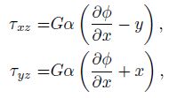
3.1 Modeling and CalculationZhang(1982)used a rectangular section beam to show pivotal movement of a strike-slip fault directly. The fault plane size and axis orientation are shown in Fig. 6a; the semi-inverse method in elastic mechanics is used to obtain the stress function of elliptic boundary condition in the rectangle. The shear stress is obtained as follows

|
Fig.6 (a) Pivotal model of fault plane; (b) Stress distribution of shear in rectangular section (Zhang, 1982) |
The rectangular cross section in Fig. 6b shows that the shear stress was gradually reduced from the periphery to the middle. A similar situation occurred for the stress on the plane of the pivotal fault, which indicates that the pivotal axis and fault plane were in different tectonic stress environments.
This paper assumed that the fault occurred in an elastic, homogeneous cuboid. Nodes were fixed on the contact surface to simulate the fault plane and pivotal axis. Weakening belts were attached to both sides of the contact surface, which had a lower shear modulus than that in the surrounding blocks. The action of principal compressive stress, and the stress field remained unchanged during the simulation process. The model dimensions were 56 km in length, 40 km in width, and 40 km in depth, which is twice the focus depth. X indicates the fault strike direction(340°). The fault plane was a tilted interface divided into two rectangular, nearly vertical solid parts, and the coefficient of friction was 0.5. The dip angle was 80° SW. Areas of 4 km on each side of the fault plane were set as weak belts with a shear modulus of one-tenth the normal value. The model was divided into tetrahedron elements(Solid 186)with a side length of 4 km outside and 2 km inside the weak belts. The number of elements and nodes were 39354 and 60373, respectively. Principal compressive stress(MPa)was applied on the fault plane elements and was decomposed along the X, Y direction. Several nodes in the central fault plane were fixed as the pivotal axis and block region(n = 14; Fig. 7). Related parameters of the fault model are shown in Table 1.

|
Fig.7 (a) Daqing mechanic model and (b) its cells division |
| Table 1 Parameters of Daqing model |
As previously mentioned, the dip of the fault plane in our model does not change; however, the strike commonly changes in strike-slip faults. Therefore, we also established a model with an opposite dip on the south and north of the pivotal axis. Although the structure and boundary conditions were more complex, little difference was noted between the numerical simulation results. Thus, we do not further discuss this second model.
The main work of this paper was accomplished in the following steps:
(1)We simulated pivotal movement of two walls of the fault under a regional stress field in the stress accumulation stage. We applied horizontal stress to the elements in the fault plane, decomposed along the X, Y direction(X: 5.1; Y : 3), and calculated the movement and deformation of the fault with some nodes(n = 14)in the center and the western wall fixed.
(2)We analyzed the influence of dip angle and block area on pivotal movement. We changed the dip angles(80°, 70°) and block areas(2.8 km2, 11 km2), calculated the movement and deformation of the fault with some nodes(n = 14)in the center and the western wall fixed as well, and compared the maximum vertical displacement resulting from the calculations performed in step(1).
(3)We researched the distribution and changes of stress in the fault plane in pivotal movement, and we fixed the side face of the solid rectangle.
3.2 Discussion 3.2.1 Pivotal movement under horizontal stress fieldThe simulation results showed that pivotal movement of a strike-slip fault controlled by a regional horizontal stress field is similar to torsion of the rectangular beam section, which was tilted in a typical manner(Fig. 8). As shown in Fig. 8a, the simulation results demonstrated the displacement distribution in the vertical direction(Z). Negative values indicate a displacement direction contrary to the positive direction, which is the maximum uplift; positive values indicate that the displacement direction is consistent with the positive direction, which is the maximum subsidence. Torque changed on the section of the model. Closer to the center, the torque caused by shear stress was small, as shown in Fig. 8b, and similar to Fig. 6b. The eastern wall rotated along the fault plane; the northern and southern walls declined and uplifted, respectively; and the vertical displacement in the middle was zero. These results indicate that the northern fault was normal and the southern fault was a thrust fault. Regarding geomorphology, the eastern wall to the north represents uplift, whereas the eastern wall to the south represents a basin. These results are consistent with the structure and deformation characteristics of Zemuhe fault.

|
(a) Displacement of two walls; (b) Displacement of moment. Fig.8 Pivotal movement of Daqing fault |
In this model, pivotal movement is related to horizontal stress, friction on fault plane, and axis properties. Friction is controlled by the friction coefficient and the dip angle of fault plane, whereas the area of the block region represents the axis properties. Under the conditions of horizontal stress and a constant friction coefficient, the changes of dip angle of the fault plane and the area of the block region are able to alter the state of the pivotal movement.
3.2.2.1 Dip angle of fault planeCalculations indicate an increase in uplift and subsidence of vertical displacement with an obvious decrease in dip angle from 80° to 70°. The maximum uplift of the eastern wall increased from 4599 m to 30865 m, and maximum subsidence increased from 4534 m to 32097 m(Fig. 9). These results may have occurred because the decrease of the fault plane angle led to a reduction in normal stress and friction on the plane, which is more conducive for sliding along the fault plane and producing pivotal movement.

|
Fig.9 Influence of dip angle of fault plane resulting in changes in pivotal movement |
A gradual increase in the block region area resulted in an increase in the number of fixed nodes, a comparison of the changes in vertical displacement of the two walls revealed their impact on pivotal movement. When the block region area was 11 km2(n = 39), the increase in area caused significant decrease in uplift and subsidence of the vertical displacement. The maximum uplift of the eastern wall decreased from 4599 m to 1093 m, and the maximum subsidence decreased from 4534 m to 1087 m, indicating an obvious hindrance of tilting movement(Fig. 10). Because increases in areas make stress more likely to accumulate and concentrate, pivotal movement along the fault plane becomes blocked.

|
Fig.10 Influence of block area changes on pivotal movement |
Free movement of the two walls of a fault is ideal. Therefore, we considered that the movement must be terminated at both ends and that the deformation is concentrated near the fault such that the displacement far away from the fault plane is zero. Therefore, we changed the model’s boundary conditions to be fixed at every side of the region except for the top and bottom by setting displacement to zero.
Because stress can accumulate at the pivotal axis, an examination of its concentration mechanism is essential. By determining the distribution of the stress state in the fault plane, it was discovered that the pivotal movement resulted in two stress centralization areas and that stress on the fault plane centralized from all directions to the block region. The largest amount of stress incurred during the entire stage, approximately 116 MPa, occurred in the core, as indicated by the red color in Fig. 11. The area of the block region continually increased, particularly at the outside, which indicates that stress centralized from outside to the core. The area of the core was approximately 0.01 km2, which is significantly smaller than the block region of 2.8 km2.

|
(a) Appearance of stress centralization area; (b) Increase in stress centralization area; (c) Further stress concentration,as indicated by yellow point; (d) Core appearance, as indicated by red point. Fig.11 Localization process in Daqing fault plane |
Thus, it is evident that stress on the fault plane centralizes from all directions to the block region. One stress centralization area continues to accumulate stress, and stress centralizes from the outside to the core, which continually increases. The largest amount of stress in the entire stage always occurs in the core, the area of which is significantly smaller than that of the block region. This process requires a lengthy period and includes the entire stage of pivotal movement, which is represented by the processes of localized deformation and earthquake nucleation, which differs from earthquake nucleation in the short-term in geophysics.
4 CONCLUSIONIn this study, we examined the tectonic and geomorphic deformation characteristics of the Daqing fault to determine its pivotal movement process, stress evolution, and localization using field observation and numerical simulation results. The following conclusions were drawn:
(1)The pivotal movement of Daqing fault along the fault plane is controlled by a regional horizontal stress field similar to torsion of the rectangular beam section, which is typically tilted. The structural and geomorphic distribution in four quadrants was formed by pivotal movement resulting from a local stress field caused by a strike-slip fault rather than by regional deformation.
(2)Two factors influencing pivotal movement include the dip angle of the fault plane and the area of the block region. When the dip angle decreases, vertical displacement also increases and results in tilting. When the area of the block region increases, vertical displacement decreases, and tilting is blocked.
(3)Stress on the fault plane centralizes from all directions to the block region. One stress centralization area continues to accumulate stress, and the stress centralizes from outside to the core, which continually increases in size. The largest amount of stress during the entire stage always occurs in the core, which is significantly smaller than the block region. The formation processes of the core include stress localization and concentration in addition to nucleation.
Tectonic movement in the deep crust and earthquake source occurrence, as well as the development and rupture processes, are the issues at the forefront of research. However, these processes are complicated and remain poorly understood. The deformation localization theory and nucleation theory, including the numerical simulation of pivotal movement of Daqing fault discussed in this paper, will provide new underst and ing on these issues. The numerical simulation in this paper allows for the possibility of using pivotal movement to explain the deformation and seismogenic mechanism of strike-slip faults. Further research on this topic is planned for the future.
5 ACKNOWLEDGMENTSThe authors appreciate the constructive comments from reviewers and the help of Ma Ji for her meticulous work in writing and modification. The authors would like to thank Enago(www.enago.cn)for the English language review as well.
| [1] | Beroza G C, Ellsworth W L. 1996. Properties of the seismic nucleation phase. Tectonophysics, 261(1-3):209-227. |
| [2] | Bo W J. 2003. A study on crustal deformation of continent of China and mechanism seismogenic process. Earthquake Research in Shanxi (in Chinese), (3):37-45. |
| [3] | Benjamin S. 2008. Modern strain localization in the central Walker Lane, weatern United States:implications for the evolution of intraplate deformation in transtensional settings. Tectonophysics, 457:239-253. |
| [4] | Burchfiel B C, Hodges K V, Royden L H. 1987. Geology of Panamint valley-saline valley pull-apart system, California:Palinspastic evidence for low-angle geometry of a Neogene range-bounding fault. Journal of Geophysical Research, 92(B10):10422-10426. |
| [5] | Chinnery M A. 1961. The deformation of the ground around surface faults. Bull. Seismol. Soc. Amer., 51(3):355-372. |
| [6] | Chinnery M A. 1963. The stress changes that accompany strike-slip faulting. Bull. Seismol. Soc. Amer., 53(5):921-932. |
| [7] | Deng Q D. 1984. Behavior of fault and basin types and their formation mechanism. Journal of Earthquake Studies (in Chinese), 1-6, (1):59-64; (2):57-64; (3):56-64; (4):58-64; (5):58-64; (6):51-59. |
| [8] | Deng Q D. 1985. Rupture mechanisms of the Fuyun earthquake fault zone.//Seismological Bureau of Xinjiang Uygur Autonomous Region, The Fuyun Earthquake Fault Zone in Xinjiang, China, chapter 5 (in Chinese). Beijing:Seismological Press, 105-119. |
| [9] | Du P S. 2000. Slip displacement and its rate about Zemuhe faults. Earthquake Research in Sichuan (in Chinese), (1-2):49-64. |
| [10] | Earthquake Administration of Sichuan. 1986. Earthquake Hazard Research of Panxi Region (in Chinese). Chengdu:Sichuan Science and Technology Press. |
| [11] | Ellsworth W L, Beroza G C. 1995. Seismic evidence for an earthquake nucleation phase. Science, 268(5212):851-855. |
| [12] | Feng J L, Zhong T Y, Wen K W. 1999. Nonlocal continuum model and its numerical simulation for localization problem.Acta Mechanica Solida Sinica (in Chinese), 20(1):16-25. |
| [13] | Feng Y B, Du P S, Huang Y S. 2000. Earthquake rupture belt of 1850 Xuchuan M7.5 earthquake. Earthquake Research in Sichuan (in Chinese), (1):80-96. |
| [14] | Feng Y B, Jiang Y M. 2000. Active tectonic of the east part of Sichuan Yunnan block. Earthquake Research in Sichuan(in Chinese), (1-2):5-23. |
| [15] | Grant L B, Donnellan A. 1994. 1855 and 1991 surveys of the San Andreas fault:implications for fault mechanics. Bulletin of the Seismological Society of America, 84(2):241-246. |
| [16] | Guo Z J, Qin B Y. 1996. Overview of research on nucleating process of earthquake sources. Recent Developments in World Seismology (in Chinese), (2):1-5. |
| [17] | He C R. 2000. Numerical simulation of earthquake nucleation and precursory process in slipping fault planes. Earthquake Research in China (in Chinese), 16(1):1-13. |
| [18] | He H L, Ren J W. 2003. Holocene earthquakes on the Zemuhe fault in southwestern China. Annals of Geophysics, 46(5):1035-1051. |
| [19] | Hu M Q. 2010. Applied research of 3D numerical simulation with parallel computing of nowadays tectonic deformation analysis in north China (in Chinese)[Master's thesis]. Beijing:Institute of Geology, China Earthquake Administration. |
| [20] | Huan W L, Zhang X D, Song Z Y. 1995. Characteristic of tectonic deformation field of strike-slip seismogenic structure in internal of mainland of China. Acta Seismologica Sinica (in Chinese), 17(2):139-147. |
| [21] | Hurukawa N. 1998. The 1995 off-Etorofu earthquake:joint relocation of foreshocks, the mainshock, and aftershocks and implications for the earthquake nucleation process. Bulletin of the Seismological Society of America, 88(5):1112-1126. |
| [22] | Institute of Geology, State Seismological Bureau, Seismological Bureau of Ningxia Hui Nationality Autonomous Region. 1990. Active Fault Zone of Haiyuan (in Chinese). Beijing:Seismological Press. |
| [23] | Institute of Water Resources and Hydropower, Planning and Design Institute of Water Resource and Hydropower, Institute of Information of Water Conservancy Power. 1991. Manual of Rock Mechanics Parameters (in Chinese).Beijing:Water Resource and Hydropower Press. |
| [24] | Li P. 1993. Xianshuihe-Xiaojiang Fault Zone (in Chinese). Beijing:Seismological Press. |
| [25] | Li T S. 1996. Hinge movement and strong earthquake along the northwest part of Xianshuihe fault. Earthquake Research in Sichuan (in Chinese), (4):62-70. |
| [26] | Li T S, Du Q F, You Z L, et al. 1998. Active Fault Zone of Xianshuihe and Its Assessment of Large Earthquake Hazard(in Chinese). Chengdu:Map Press of Chengdu. |
| [27] | Liu Z Y, Huang P G, Jin Z L, et al. 1999. 1970 Tonghai Earthquake (in Chinese). Beijing:Seismological Press. |
| [28] | Luo Z L. 1980. Stress deformation and tilt fields of the earthquake source. Acta Seismilogical Sinica (in Chinese), 2(2):169-185. |
| [29] | Ma S L, Ma J, Liu L Q. 2002. Experiment evidence of earthquake nucleation phase. Chinese Science Bulletin (in Chinese), 47(5):387-391. |
| [30] | Malservisi R, Gans C, Furlong K P. 2003. Numerical modeling of strike-slip creeping faults and implications for the Hayward fault, California. Tectonophysics, 361(1-2):121-137. |
| [31] | Murray J, Langbein J. 2006. Slip on the San Andreas fault at Parkfield, California, over two earthquake cycles, and the implications for seismic hazard. Bulletin of the Seismological Society of America, 96(4B):S283-S303. |
| [32] | Nicholson C. 1996. Seismic behavior of the southern San Andreas fault zone in the northern Coachella valley, California:comparison of the 1948 and 1986 earthquake sequences. Bulletin of the Seismological Society of America, 86(5):1331-1349. |
| [33] | Norihito U, Okada T, Hasegawa A. 2002. Foreshock and aftershock sequence of the 1998 M5.0 Sendai, northeastern Japan, earthquake and its implications for earthquake nucleation. Bulletin of the Seismological Society of America, 92(6):2465-2477. |
| [34] | Rastogi B K, Mandalal P. 1998. Foreshocks and nucleation of small to moderate-sized Koyna earthquakes (India). Bulletin of the Seismological Society of America, 88(5):1112-1126. |
| [35] | Ren J W. 1986. Seismotectonic of 1850 Xichang earthquake, Sichuan, and preliminary study of paleoseismic of Zemuhe fault[Master's thesis] (in Chinese). Beijing:Institute of Geology, China Earthquake Administration. |
| [36] | Ren J W, Li P. 1989. Earthquake-caused landforms and paleoseismic study on the northern segment of the Zemuhe fault.Seismology and Geology (in Chinese), 11(1):27-33. |
| [37] | Research Group of Active Fault Zone of Altyn Tagh, State Seismological Bureau. 1992. Active fault zone of Altyn Tagh(in Chinese). Beijing:Seismological Press. |
| [38] | Simpson R W, Barall M, Langbein J, et al. 2006. San Andreas fault geometry in the Parkfield, California, Region.Bulletin of the Seismological Society of America, 96(4B):S28-S37. |
| [39] | Tang R C, Han W B. 1993. Active Faults and Earthquakes in Sichuan (in Chinese). Beijing:Seismological Press. |
| [40] | Tectonics Program, Earth Sciences Division, National Science Foundation. 2002. New Departures in Structural Geology and Tectonics. White paper. |
| [41] | The Editorial Team of 1976 Tangshan Earthquake, State Seismological Bureau. 1982. 1976 Tangshan Earthquake (in Chinese). Beijing:Seismological Press. |
| [42] | Wang C Y, Lou H, Yao Z X, et al. 2010. Crustal thicknesses and Poisson's ratios in Longmenshan mountains and adjacent regions. Quaternary Sciences (in Chinese), 30(4):652-661. |
| [43] | Wang H L. 1989. Movement pattern of Changma fault and the 1932 Changma earthquake. Journal of Seismological Research (in Chinese), 12(1):29-36. |
| [44] | Wang S B, Yao Z X. 1997. Space-time correlation research of seismogenic of Xianshuihe fault zone. Acta Seismologica Sinica (in Chinese), 19(6):600-607. |
| [45] | Wen X Z, Huang S M, Jiang Z X. 1985. Neotectonic features of the Ganzi-Yushu fault zone and its assessment of its earthquake risk. Seismology and Geology (in Chinese), 7(3):23-32. |
| [46] | Wu Z M. 1993. Internal tensile shear fault and structural position of strong earthquake occurrence. North China Earthquake Sciences (in Chinese), 11(1):11-18. |
| [47] | Xu X W, Yu G H, Ma W T, et al. 2008. Rupture behavior and deformation localization of the Kunlunshan earthquake(Mw7.8) and their tectonic implications. Science China (Series D), 51(10):1361-1374. |
| [48] | Yu W X, Wang B, Liu Y Q, et al. 2004. Characteristics of recent vertical crustal deformation in Qujiang fault and its neighbouring region. Journal of Geodesy and Geodynamics (in Chinese), 24(1):85-89. |
| [49] | Zhang P Z. 1982. Deformation characteristic and rupture mechanism of Funyun fault zone-Research of a brittle shear rupture zone[Master's thesis] (in Chinese). Beijing:Institute of Geology, China Earthquake Administration. |
| [50] | Zhang S M, Xie F R. 2001. Seismo-tectonic divisions of strong earthquakes (Ms ≥ 7.0) and their tectonic geomorphology along Xianshuihe-Xiaojiang fault zone. Acta Seismologica Sinica (in Chinese), 23(1):36-44. |
| [51] | Zhao S, Wu X, Hori T, et al. 2003. Deformation and stress localization at the Nankai subduction zone, southwest Japan.Earth and Planetary Science Letters, 206(1-2):145-160. |
| [52] | Zhou W X, Yang Z E, Sun X J, et al. 2003. Numerical modeling of the generation process of the 1906 Manas Ms7.7 earthquake. Seismology and Geology (in Chinese), (4):609-616. |