 2014, Vol. 57


2. Second Crust Monitoring and Application Center, CEA, Xi'an 710054, China
As one of the most important pathway for southeastward extrusion of the Tibetan Plateau, the mid and south parts of the eastern margin of Tibetan Plateau are featured by widespread active faults, intensive and frequent seismic activity(Tapponnier et al., 1982; Peltzer et al., 1989; Li et al., 1993; Xu et al., 2003; Wen et al., 2011). The preparation processes of earthquakes, earthquake occurrence and the impacts of earthquake disasters are all related to activity of faults. Segmentation and the long-term slip rates of active faults are a focused issue of earthquake research, as well as important basis for mid-long term earthquake hazard study(Ding et al., 1993).
Compared with geological observations, GPS measurement is capable of providing data of surface motion variations with higher spatial resolution and more flexible time scales. Especially, using long-term interseismic GPS velocity fields, and combined with geological and geophysical studies, fault slip rates can be obtained by inversion, which are a useful supplement to surveying fault activity by geological methods(Meade et al., 2005, 2007; Wang et al., 2008; Wang et al., 2010; Loveless et al., 2010; Chen et al., 2000; Bo et al., 2013).
In recent years, a lot of research work has been done on crustal motion by using GPS measurements in the mid and south parts of the eastern margin of the Tibetan Plateau(Shen et al., 2002; Lü et al., 2003; Shen et al., 2005; Gan et al., 2007). Shen et al.(2002)modeled the slip rates of some faults in this area by an elastic dislocation model. Considering the rigid block rotation, Lü et al.(2003) and Shen et al.(2005)obtained the fault slip rates of main active faults in this area. Meade et al.(2007) and Wang et al.(2010)modeled the main active fault slip rates by using linear spherical block theory, in which the GPS velocity field is decomposed into rigid block motion and the elastic deformation from coseismic slip deficits, but they did not take account of subblocks and some other important faults founded recently(Xu et al., 2003, 2008; Shen et al., 2005; He et al., 2008) and the influence of homogeneous internal block strain on the GPS velocity field.
In this study we adopt the linear spherical block theory(Meade et al., 2009)to build a fault geometry model based on pervious research of active faults(Zhang et al., 2003). Then we use interseismic GPS observations to calculate fault slip rates and optimal locking depths of main active faults in the mid and south parts of the eastern margin of the Tibetan Plateau. Furthermore, in terms of these slip rates, we estimate the rates of moment accumulation on these faults and compare them with seismic moment release.
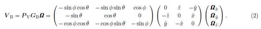
2 LINEAR SPHERICAL BLOCK THEORYNominally interseismic GPS velocities record combined effects of plate motions, permanent deformation, and elastic strain accumulation(Loveless et al., 2011). Through an idealized earthquake cycle, interseismic elastic strain accumulation complements coseismic strain release, so that there is no net elastic strain accumulation in the crust surrounding seismogenic faults(Savage et al., 1973). In recent years, Meade et al.(2005, 2009)have developed new linear spherical block theory, in which one assumption is that every fault in the model is locked in interseismic time, so the interseismic velocity field(V I)can be written as

Blocks motions in spherical coordinates can be defined using a Cartesian rotation vector, Ω, where $\hat x$ = RcosΦ cos θ, $\hat y$ = RcosΦ sin θ, $\hat z$ = Rsin θ(R represents radius of the Earth)are the Cartesian station coordinates. Both the cross product and the conversion from Cartesian to ENU velocity, V B, can be written in terms of linear operators:
We also have

The kinematically consistent slip rate at the midpoint of a fault segment is proportional to the differential velocity predicted by the relative rotation of the bounding blocks(p and q in this case)on either side.
For each block, the contribution to the velocity field resulting from intrablock strain is
The second term of the velocity field(Eq.(1))is relative to interseismic strain accumulation, so it can well correspond to long-term fault slip rate(Savage et al., 1973). The predicted interseismic velocity at a point is equal to the sum of the block rotation rate, homogeneous internal block strain and the integrated effects of elastic strain accumulation from all faults. In this theory, block rotation, the coseismic deficit slip rate and homogeneous internal block strain can be obtained simultaneously, constrained by GPS data.
3 ESTABLISHMENT OF BLOCK GEOMETRYActive blocks are geological units with a relatively uniform movement pattern which are confined and divided by tectonic zones. These tectonic zones were formed in the Late Cenozoic and Quaternary, and are still active today(Zhang et al., 2003). The block geometry is constructed according to above principles and basis. In specific construction, we combine the active block model of China mainl and given by Zhang et al.(2003) and the GPS horizontal velocity field.
For the Bayan Har block between the Mani-Yushu-Xianshui He fault and Kunlun-Maqên fault, we divide it into the Aba sub-block and Longmen Shan sub-block which are separated by the Longriba fault(Shen et al., 2005).
The Sichuan-Yunnan block bounded by Xianshui He-Xiaojiang, Honghe River and Jinshajiang faults(Kan et al., 1997)is divided into Chuanxibei and Dianzhong sub-blocks by the Lijiang-Xiaojinhe fault. According to the GPS data(Shen et al., 2005), historic seismic surface ruptures and focal mechanism solutions(Chen et al., 2012), and the weak activity of northern section of the Honghe River, the Northwest Sichuan sub-block is divided into Yajiang and Shangri La sub-blocks by the Litang fault, and the west boundary of Shangri La sub-block is adjusted to the Dêqên-Zhongdian-Daju fault. The construction of the Dianzhong sub-block was proposed by Cheng et al.(2012), and its west boundary is the Honghe River(Zhang et al., 2005; Zhang et al., 2013; Zhang et al., 2003; Wang et al., 2011). The Daliangshan sub-block is bounded by Daliangshan and Anninghe-Zemuhe faults(Cheng et al., 2011; Wei et al., 2012).
The Diannan sub-block confined by Nujiang-Longling-Lancang and Honghe River faults is divided into Baoshan and Jinggu sub-blocks by the Nantinghe fault(Zhang et al., 2003; Cheng et al., 2012).
Finally, we get 12 sub-blocks: mainly including the Aba sub-block, Longmen Shan sub-block, East Tibet sub-block, Yajiang sub-block, Shangri La sub-block, Dianzhong sub-block, Baoshan sub-block, Jinggu sub-block, South China and Mi and ian block. These sub-blocks are separated by Longriba fault, Longmen Shan fault, Garzê-Yushu fault, Xianshuihe fault, Anninghe fault, Zemuhe fault, Daliangshan fault, Xiaojiang fault, Litang fault, Lijiang-Xiaojinhe fault, Dêqên-Zhongdian-Daju fault, Honghe River fault, Jinshajiang fault, Longling-Lancang fault, Nantinghe fault, Minjiang fault. These sub-blocks and faults are shown in Fig. 1.

|
Fig.1 Block boundaries(white lines)of the block model in mid and south part of the eastern margin of the Tibetan Plateau Gray lines are major boundary faults(Cheng et al., 2012). Inset shows block boundaries(black lines)of the overall block model. F1-East Kunlun fault; F2- Longriba fault; F3-Yushu fault; F4-Xianshuihe fault; F5-Longmen Shan fault; F6 Minjiang fault; F7 Anninghe fault; F8 Zemuhe fault; F9 Daliangshan fault; F10 Xiaojiang fault; F11 Lingjiang-Xiaojinhe fault; F12 Chenghai fault; F13 Honghe River fault; F14 Lancang-Longling fault; F15 Nantinghe fault; F16 Nujiang fault; F17 Dêqên-Zhongdian-Daju fault; F18 Jinshajiang fault; F19 Batang fault; F20 Litang fault; F21 Garzê-Litang fault; F22 Jiali-Zay¨u fault. I Aba sub-block; II Longmen Shan sub-block; III East Tibet sub-block; IV Yajiang sub-block; V Shangri La sub-block; VI East Lhasa sub-block; VII Daliangshan block; VIII Dianzhong sub-block; IX Baoshan sub-block; X Jinggu sub-block; XI Mi and ian block; XII South China block. |
The fault planes in the model are assumed to be upright, mainly based on the following considerations:(1)Deep geometries of most faults are unknown.(2)The vast majority of GPS stations are away from the faults, so the GPS horizontal velocities are not sensitive to deep geometries of faults. The obtained fault slip rates contain strike slip component and convergence/extension slip component. The assumption that the convergence/extension slip rates for an vertical fault can be similar to a non-vertical thrust/normal fault has been used by many previous researches(Meade et al., 2005, 2007; Wang et al., 2008; Loveless et al., 2011; Wang et al., 2011; McCaffrey et al., 2005). As the fault planes are assumed to be upright, so the dip-slip is characterized by horizontal convergence and extension, respectively.
4 GPS DATAThe GPS data used in this study is from the Crustal Motion Observation Network of China(CMONOC)from 1999 to 2007(Niu et al., 2002), including four campaigns for all sites in 1999, 2002, 2004 and 2007, respectively. The GPS data were processed using the GAMIT/GLOBK software(Herring et al., 2009). All of the observational data for a given day were combined, and the GAMIT software was used to solve for the loosely constrained daily station coordinates, polar motion and satellite orbits. Then, the daily solutions for the local stations were combined with the loosely constrained global solutions from the Scripps Orbital and Position Analysis Center using the QOCA software(Dong, 1998). The stable global IGS sites around China were used as the reference stations for ITRF2005 to obtain tight constraints on the positions. Finally, the time series of positions with respect to ITRF2005 was obtained for each station(Wang, 2009). In this paper, 301 GPS stations are selected after some outliers are detected to be caused by various nontectonic sources. The mean uncertainties of this reduced GPS data set are 1.36 mm·a-1 in the east-west direction and 1.35 mm·a-1 in the north-south direction, respectively(Fig. 2).

|
Fig.2 GPS velocity field of research area with respect to Eurasia frame(Error ellipses represent the 70% confidence level) |
The near surface interseismic locking produces a smooth velocity gradient from one block to the adjacent block across faults. A deeper locking depth would cause broader strain distribution, and vice versa. The locking depths can be constrained in the block model by fitting GPS data(Wang et al., 2011). Figure 3 shows the extent of GPS data fitting variations relative to different locking depths of faults. The optimal locking depth is obtained by using the chi-square test, corresponding to the minimum RMS${\chi ^2}$:

In this way, a uniform locking depth for all faults can be determined, which is used as the initial value in our model(Fig. 3a). The optimal locking depth is about 21 km. Then the optimal locking depths of some other main active faults are fixed(Figs. 3(b-d)). In this study, the locking depths estimated from the block model are generally consistent with those indicated by focal depths(Zhang et al., 2002; Zhu et al., 2005; Yang et al., 2005).

|
Fig.3 Optimal fault locking depths for mid and south parts of the eastern margin of the Tibetan Plateau(a)Average values of faults;(b)Longmenshan fault;(c)Xianshui He fault;(d)Xiaojiang fault. |
Using the optimal locking depths of the major faults, modeled site velocities are obtained. The results are in good agreement with the GPS velocities(Fig. 4, Fig. 5a). Fig. 5b shows that about 70.6% of the residual velocity components are smaller than 1 mm·a-1. The large misfits are mainly found around the Aba sub-block, East Tibet sub-block and East Lhasa sub-block, where the GPS sites are sparse and the observational errors are relatively large.

|
Fig.4 Modeled GPS velocities by the blocks model |

|
Fig.5 Residual velocities(the difference between the predicted and the GPS site velocities)The inset shows the distribution of residual velocities. |
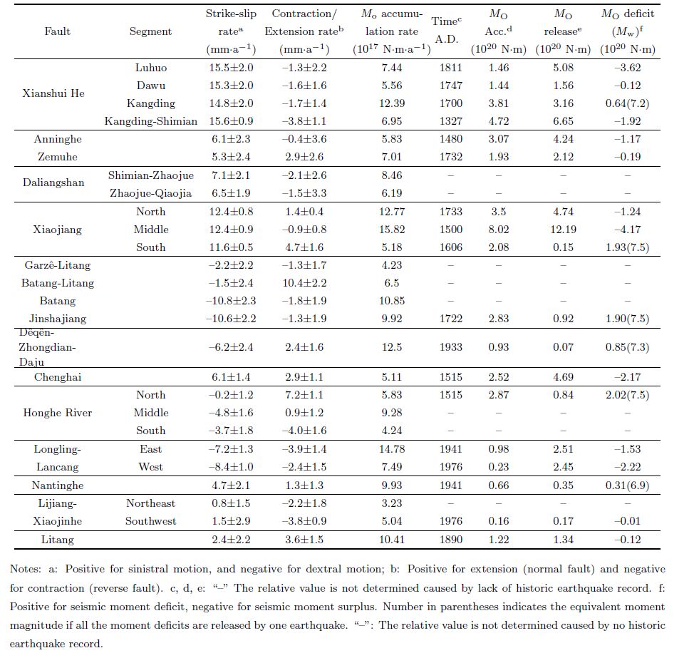
Based on the optimal block model, we obtained fault slip rates of main active faults in the mid and south part of the eastern margin of the Tibetan Plateau(Fig. 6 and Table 1). The Garzê-Yushu fault, Xianshuihe fault and Xiaojiang fault are the most active characterized by left-lateral strike-slip. The active right-lateral strike-slip faults are located west of the Sichuan-Yunnan block. More detailed analysis of the inversion results is given in the following sections.

|
Fig.6 Predicted fault slip rates along major active faults(a)Blue color represents sinistral slip, red color denotes dextral slip;(b)Blue color represents extensional slip, red color denotes converged slip. Thickness of lines is proportional to the rates(scales are shown in the legend). |
| Table 1 Predicted fault slip rates of major faults |
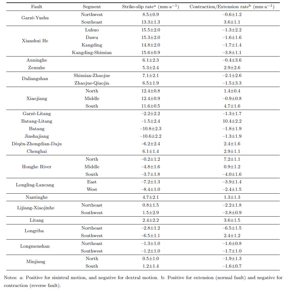
The Garzê-Yushu fault, Xianshuihe fault, Anninghe fault, Zemuhe fault, Daliangshan fault and Xiaojiang fault are arc-shaped active fault zones characterized by left-lateral strike-slip in the eastern margin of the Tibetan Plateau.
Bounding the southern margin of the Bayan Har block is the Garzê-Yushu fault, where the predicted left-lateral strike slip rate is 13.3±1.3 mm·a-1, the convergence rate is 0.6±1.2 mm·a-1 across its NW segment, and from west to east the extension becomes significant across the SE segment. These left-lateral strike slip rates are similar to previous estimates, which are 12±2 mm·a-1(Wen et al., 2003) and 14±3mm·a-1(Xu et al., 2003), and are higher than the 7 mm·a-1 reported by Zhang et al.(1996).
All segments of the Xianshuihe fault are not significantly different in left-lateral strike slip rates, of which Luhuo, Dawu, Kangding and Kangding-Shimian are 15.5±2.0 mm·a-1, 15.3±2.0 mm·a-1, 14.8±2.0 mm·a-1, 15.6±0.9 mm·a-1, respectively, where our predicted left-lateral strike slip rates of the Dawu segment and Kangding segment are consistent with the previous geological results(Wen et al., 2000; Zhou et al., 2001). Xu et al., 2003 suggested that the uplift rate of the south segment of the Xianshui He fault is about 3.2 mm·a-1, which is associated with the impeded southwest part of the fault. Our predicted convergence of the Kangding-Shimian segment is about 3.8±1.1 mm·a-1, which comparable with the uplift rate(4 mm·a-1)of this area with respect to the Sichuan basin constrained by long-term levering data(Hao, 2012).
The Xianshui He fault splays at Shimian into two branches: Anninghe-Zemuhe and Daliangshan faults, which are all characterized by left-lateral strike slip. We determine the slip rates of the Anninghe and Zemuhe faults to be 6.1±2.3 and 5.3±2.4 mm·a-1, respectively. The strike-slip rate of the Anninghe fault is consistent with that reported by Ran et al.(2008)(5 mm·a-1), Pei et al.(1997)(5.5~8.5 mm·a-1) and Xu et al.(2003)(6.1±1 mm·a-1). The strike-slip rate of the Zemuhe fault is consistent with the result reported by Xu et al.(2003)(6.4±0.6 mm·a-1).
Our results reveal 7.1±2.1 mm·a-1 left slip and 2.1±2.6 mm·a-1 convergence across the north segment of the Daliangshan fault. Left slip and convergence are 6.5±1.9 mm·a-1 and 1.5±3.3 mm·a-1 for the south segment of the Daliangshan fault, respectively. These values are higher than the geological results, which are left slip of 3~4 mm·a-1(Wei et al., 2012). We indicate that the Daliangshan fault is in a newly born state, so partial slip is shared by some small and secondary faults, which may be the reason for these differences.
Our results show the Xiaojiang fault is of left slip at 12.4±0.8 mm·a-1, and its north and south segments are of 1.4±0.4 mm·a-1 and 4.7±1.6 mm·a-1, respectively. The left slip is consistent with the 13.0~16.5 mm·a-1 reported by He et al.(2002).
When the GPS data are used to study the fault slip, the differences of the interval of observations, scale of the model and the mathematical theory may significantly affect the modeling results, so it is necessary to compare with the other studies as the same interval as possible. Our results across Xianshui He-Xiaojiang fault zone are generally consistent with the previous studies constrained on GPS(Meade et al., 2007; Wang et al., 2008; Wang et al., 2010; Shen et al., 2005).
5.2 Jinshajiang-Honghe River Fault ZoneBounding the western margin of the Sichuan-Yunnan block, the Jinshajiang-Honghe River fault zone is symmetric to the Xianshui He-Xiaojiang fault zone that is an important right-lateral arc-like fault zone.
The right-lateral strike slip rates of the Jinshajiang fault and Dêqên-Zhongdian-Daju fault are 10.6±2.2 mm·a-1 and 6.2±2.4 mm·a-1, respectively. Their convergences are 1.3±1.9 mm·a-1 and 2.4±1.6 mm·a-1, respectively. Their strike-slip rates are consistent with the 6~7 mm·a-1 and 5±1.0 mm·a-1 slip, respectively(Xu et al., 2003; Shen et al., 2001).
The previous study indicates that the left slip of the Chenghai fault and Nantinghe fault are continuous(Socquet et al., 2005). We determine their slip rates are 6.1±1.4 mm·a-1 and 4.7±2.1 mm·a-1, and their extensions are 2.9±1.1 mm·a-1 and 1.3±1.3 mm·a-1, respectively. The left slip of the Nantinghe fault is higher than 2.7 mm·a-1 reported by Xu et al.(2003).
The Honghe River fault is the SW boundary of the Sichuan-Yunnan block. Guo et al.(1996)indicate that the north segment of this fault(from Eryuan to Midu)is active with right-lateral slip at a rate 1.5 mm·a-1 since Holocene, and slip rates of its mid and south segments are 3.6 mm·a-1 and 3.7 mm·a-1, respectively. The northern segment of the Honghe River is a normal fault, its dip slip rate is about 0.9 mm·a-1, while dip slip rates are small on its mid and south segments. Our results reveal that the strike slip of north segment of the Honghe River fault is slightly smaller, and its extension is about 7.2±1.1 mm·a-1. However, the right-lateral strike slip rates of mid and south segments are 4.8±1.6mm·a-1 and 3.7±1.8mm·a-1, respectively. Our results are consistent with previous study(Guo et al., 1996). On the other h and , our modeling results are also consistent with Shen et al.(2005) and Wang et al.(2008).
5.3 Nujiang-Longling-Lancang Fault ZoneWe can see that the west side of the Nujiang fault is loosely constrained by data(Fig. 3), so the results of this fault are not reliable and not discussed here. Our results reveal 7.2±1.3 mm·a-1 right slip and 3.9±1.4 mm·a-1 convergence across the Longling-Lancang fault. Its strike-slip rate is consistent with the 5.3±1.1 mm·a-1 slip reported by Xu et al.(2003) and Guo et al.(2000) and close to the 6 mm·a-1 slip from GPS(Shen et al., 2005).
5.4 Faults Within the Sichuan-Yunnan BlockThe Lijiang-Xiaojinhe fault is a sub-block boundary within the Sichuan-Yunnan block, and active since Holocene(Xiang et al., 2002). Our results reveal 1.5±2.9 mm·a-1 left slip and 3.8±0.9 mm·a-1 shortening across its SW segment, 0.8±1.5 mm·a-1 left slip and 2.2±1.8 mm·a-1 shortening across its NE segment. Xu et al.(2003)measured the left slip and thrust slip rates as 3.8±0.7 mm·a-1 and 0.64±0.14 mm·a-1, respectively. Its left and thrust slip rates are 3.7~3.8 mm·a-1 and 1.0~1.5 mm·a-1(Xiang et al., 2002). Our results are generally consistent with previous study based on GPS constraint(Deng et al., 2010).
The Litang fault is a boundary fault(Shen et al., 2005; Cheng et al., 2012), and such definition is adopted in this study. Our results reveal 2.4±2.2 mm·a-1 right slip and 3.6±1.5 mm·a-1 extension across this fault. Its strike-slip rate is slightly lower than 4±1 mm·a-1 reported by Xu et al, (2005).
5.5 The Longmenshan Fault and Longriba FaultOn the Longmenshan fault, 1.2±1.0 mm·a-1 right slip and 1.7±1.0 mm·a-1 convergence characterize its SW segment, 1.3±1.0 mm·a-1 right slip and 1.6±0.8 mm·a-1 convergence across its NE segment, which are compatible to the long-term average slip rate by geological study(Ma et al., 2005; Zhou et al., 2006).
The modeling results of the Longriba fault show that right slip rate 6.1±1.1 mm·a-1 and 2.4±1.2 mm·a-1 extension characterize its SW segment and 2.6±1.2 mm·a-1 convergence on its NE segment, where the right slip rate and convergence of NE segment are consistent with the 5.3±2.0 mm·a-1 and 0.7 mm·a-1, respectively(Xu et al., 2008). It is notable that considering the existence of the Longriba fault or not, the model results on the Longmenshan fault are different significantly. Our results is consistent with the results of Deng et al.(2010) and Wang et al.(2009), but obviously lower than the results of Wang et al.(2011) and Zhao et al.(2012).
6 SEISMIC MOMENT BALANCEThe balance between elastic strain accumulation during the interseismic time and its release by earthquakes may contribute to a better underst and ing of earthquake hazard(Meade et al., 2005; Wang et al., 2009, 2011).
Using the moment deficit method, Wang et al.(2009)predicted the mid-long term earthquake hazard of major active faults around the Bayan Har block and its vicinity. This study focuses on the Sichuan-Yunnan region and its vicinity, and uses the predicted slip rates and optimal locking depths to estimate the rates of moment accumulation on the major active faults in the study area, and compare the results with seismic moment release estimated by using earthquake records, to identify faults of large moment deficit(unreleased moment).
6.1 Seismic Moment Accumulation The moment accumulation rate for a given fault is the product of shear modulus(μ), fault area(A), and slip rate magnitude(s),  . Using a shear modulus of μ = 30 GPa, if the time interval is given, the moment accumulation can be estimated based on the optimal locking depth(Table 2).
| Table 2 Slip rates and moment balance of major faults |
Seismic moment(MO)released by an earthquake can be estimated from its moment magnitude(Mw):

Because the difference between the Mw and Ms is usually small, we treat all magnitudes in the catalog as Mw in the estimation of seismic moment release(Wang et al., 2009, 2011).
Using Eq.(7), the seismic moment release is estimated to be 4.91×10²¹ that is lower than the seismic moment accumulation during 1500~2007, which is equivalent to the moment released by an Mw8.1 earthquake. It shows that the study area has high risk of major earthquakes. The individual seismic moment deficit of main boundary faults will be discussed in the next sections.
6.3 Seismic Moment DeficitA complete and credible major earthquake catalogue is essential for estimating the seismic moment release and its deficit(Wang et al., 2011). In this study, we collect 66 major events(Table 3), which are of more credible(Xu et al., 2005; DEDPCEA, 1995, 1999; Working group of M7, 2012; Wen et al., 2008; Yu et al., 2005). The relationship between major earthquake records and associated faults, such as the Xianshuihe-Anninghe-Zemuhe-Xiaojiang fault zone are from literature(Wen et al., 2000; Wen et al., 2008). For western Yunnan, including the Jinshajiang fault, Dêqên-Zhongdian-Daju fault, Honghe River fault, Longling-Lancang fault and Nantinghe fault, the relationship between major earthquake records and associated faults are given by the relative references(DEDPCEA, 1995, 1999; Working Group of M7, 2012). The major earthquake records of the Chenghai fault and Lijiang-Xiaojinhe fault are from the previous studies(DEDPCEA, 1995, 1999; Xu et al., 2003; Yu et al., 2005). We add a strong earthquake record to Litang fault(Xu et al., 2005).
| Table 3 Earthquakes of M λ 6.0 in mid and south part of the eastern margin of the Tibetan Plateau |
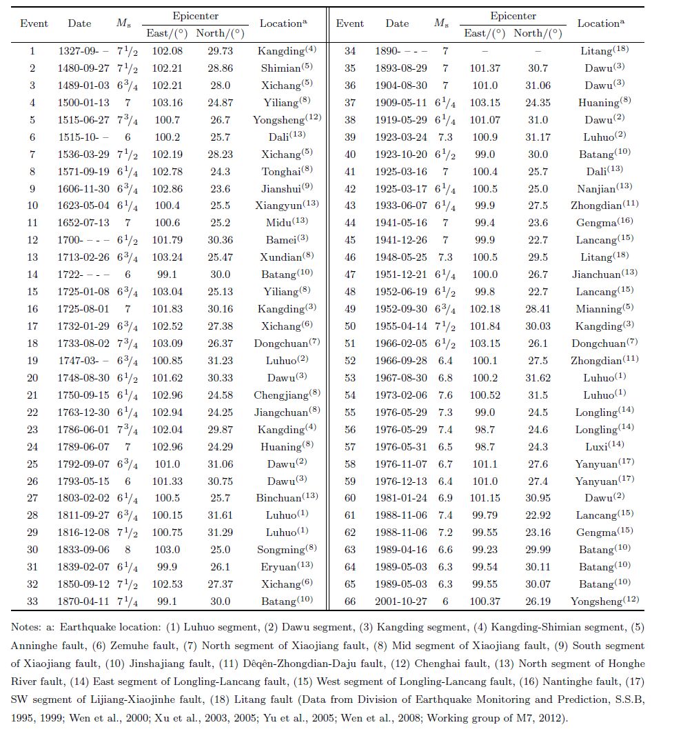
Based earthquake records above, we determine seismic moment release associated to the faults or fault segments, and compare the results with seismic accumulation to identify faults of large moment deficits(unreleased moment)(Table 2). The Kangding segment of the Xianshui He fault(0.64×10²⁰ N·m), the south segment of the Xiaojiang fault(1.93×10²⁰ N·m), Jinshajiang fault(1.90×10²⁰ N·m), Dêqên-Zhongdian-Daju fault(0.85×10²⁰ N·m), the north segment of the Honghe River fault(2.02×10²⁰ N·m) and Nantinghe fault(0.31×10²⁰ N·m)exhibit the most significant deficits in this area. Although there is no major earthquake record of the mid-south segment of the Honghe River fault, it was active in Holocene(Allen et al., 1984). Therefore we can infer that the seismic moment deficit of the mid-south segment of the Honghe River fault may be significant, considering the high seismic moment accumulation rate(9.28×10¹⁷ N·m·a-1).
7 DISCUSSIONS 7.1 Linear Spherical Block TheoryCompared with the previous elastic block models(Li et al., 2003, 2007; Wang et al., 2011), the linear spherical block theory considers coseismic deficit slip and homogeneous internal block strain. Therefore, the physical meaning of the model is more clear and complete as shown by Eq.(1).
The modeling results are more consistent with the long-term fault slip rates constrained by interseismic GPS velocity fields as long as possible by using the linear spherical block theory. The GPS data used in this study is from 1999 to 2007, which is not affected by great earthquake events, so it may be more effective for studying the long-term fault activity in the mid and south part of the eastern margin of the Tibetan Plateau.
In the modeling process, different fault geometries would have a significant impact on the results. The model used in this paper is based on previous research and improved through continuous trial. The active fault research is essential for constructing the block model. Considering the existence of the Longriba fault or not, the modeling results on the Longmenshan fault are different significantly(Wang et al., 2009; Zhao et al., 2012). The results of Wang et al.(2009), considering the existence of the Longriba fault, is obviously lower than that of Zhao et al.(2012). The fault slip rates of our results are consistent with Wang et al.(2009). Xu et al.(2008)identified the existence of the Longriba fault and elaborated on the absorption of Bayan Har block eastward flow, which leads to the Longmenshan fault showing a low slip rate. The study of Zhang et al.(2012)shows that relative to the Sichuan Basin, east of the Longriba fault, has a uplift rate about 2 mm·a-1. In contrast, the uplift rate is of a very low level on both sides about one hundred kilometer of across the Longmenshan fault, which would contribute to the locking of the Yingxiu-Beichuan fault. The Longmenshan fault is of dextral strike slip besides vertical activity, which might be due to resistance from the rigid Sichuan Basin(Clark et al., 2000; Jiang et al., 2011), rather than the explanation of crustal shortening in horizontal direction. It enlightens us that we should consider the constraint from vertical direction in normal or thrust faults.
7.2 Limitation of Seismic Moment BalanceWhen the seismic deficit theory is used for long-term earthquake hazard study, a good underst and ing of earthquake catalogue and earthquake recurrence is very important. Both incomplete earthquake catalogues and variable earthquake recurrence intervals may affect the result significantly(STein et al., 2012). An earthquake catalogue containing multiple earthquake cycles can be used to estimate seismic moment release accurately. As shown in Table 2, we can not determine the seismic release along mid-south part of the Honghe River fault because of lacking strong earthquake records in this area. In some sparsely populated areas, including the Daliangshan fault, Garzê-Litang fault, Batang-Litang fault and Batang fault, many major historical earthquakes may not be recorded, which may pose significant impact on the results.
7.3 Moment Deficit and Deep Crustal StructureSeismic moment deficit corresponds to the fault or fault segments with significant seismic accumulation and lower seismic moment release. The most earthquakes occur within the crust in the study area(Wu et al., 2004). Therefore studying the relationship between the faults with seismic moment deficits and the crustal structure would help to underst and the cause of seismic moment deficits.
The previous geophysical surveys can facilitate research of seismogenic structure and mechanisms in this region. Seismic tomography(Huang et al., 2002; Wang et al., 2003; Xu et al., 2013) and receiver function(Hu et al., 2005; Wang et al., 2008; Li et al., 2009)were used to reveal regional crustal deep structure, and the results indicate that high velocity exists within mid-to-lower crust of the Sichuan Basin. The low velocity layers are widely distributed in the West-Sichuan plateau and Yunnan. Crustal thickness shows lateral variations from south to north, and crustal thickness in the north is deeper than south. Two deep seismic sounding profiles in the West-Sichuan plateau show low velocity abnormities in middle and lower crust, the Xianshuihe fault is a super fault that may cut through the crust, the Jinshajiang fault and Garzê-Litang fault may extend to low velocity layers of mid crust. Bai et al.(2004)reviewed the wide-angle seismic data of Zhefang-Binchuan and Menglian-Malong and suggested that as a super fault, the Nujiang fault cut the crust and the lower crust has low velocity layers. Meanwhile, the Honghe River fault and Xiaojiang fault cut through crust. Zhang et al.(2013)indicates the crustal thickness across the Honghe River fault is also significantly different.
From crustal deep structure, we determine the faults of significant seismic moment deficits are big ones, which extend to the low velocity layer of mid-to-lower crust, such as the Xianshuihe fault, Jinshajiang fault and Nujiang fault. Some fault interfaces are obviously velocity interfaces, i.e. the Honghe River fault and Xiaojiang fault. Most strong earthquakes in this area are located at the transition zones where the velocity structure is changing from negative to positive, the seismic sources are located at the positive velocity anomalies underlain by negative velocity abnormities, which are prone to the accumulation of the energy and the regional stress in the upper brittle crust(Su et al., 1999; Wang et al., 2002; Bai et al., 2003). Therefore the seismic moment deficits in some special parts of faults may be related to those crust structure and geodynamic processes mentioned above.
8 CONCLUSIONSWe have derived the fault slip rates of main active faults in the mid and south part of the eastern margin of the Tibetan Plateau based on the GPS velocity field(from 1999 to 2007)by using the linear spherical block theory. Our results show that the Garzê-Yushu fault, Xianshui He fault, Anninghe fault, Zemuhe fault, Daliangshan fault and Xiaojiang fault are the most active fault zones characterized by left-lateral strike-slip in the eastern margin of the Tibetan Plateau(5.3±2.4 mm·a-1~15.6±0.9 mm·a-1). The left slip and convergence rates of the Kangding-Shimian segment are 15.6±0.9 mm·a-1 and 3.8±1.1 mm·a-1, respectively. There is no clear active fault zone revealed in the west of the Sichuan-Yunnan block. The Batang, Jinshajiang and Dêqên-Zhongdian-Daju faults are characterized by right-lateral strike slip with rates 10.8±2.3 mm·a-1, 10.6±2.2 mm·a-1 and 6.2±2.4 mm·a-1, respectively.
Using the predicted slip rates and locking depths, we estimated the rates of moment accumulation on major active faults and seismic moment release on these faults based on the reliable historic strong earthquake records. We study the balance between seismic moment accumulation and seismic release, then some significant seismic moment deficits are determined, including the Kangding segment of the Xianshui He fault, south segment of Xiaojiang fault, Jinshajiang fault, Dêqên-Zhongdian-Daju fault, Honghe River fault and Nantinghe fault. These results would be helpful for mid-long term earthquake hazard study.
ACKNOWLEDGMENTSWe thank B. Meade for providing the codes of the linear spherical block model besides his selfless help and Wang Min for providing GPS velocity data. We are grateful to anonymous reviewers for their helpful suggestions and discussion. The figures in this paper are prepared by GMT tools. This work was supported by the Program of the National Natural Science Foundation of China(41174083), and the Research Fund of China Earthquake Administration(201208009).
| [1] | Allen C R, Gillespie A R, Han Y, et al. 1984. Honghe River and associated faults, Yunnan Province, China:Quaternary geology, slip rates and seismic hazard. Geol. Soc. America Bull., 95(6):686-700. |
| [2] | Bai Z M, Wang C Y. 2004. Tomography research of the Zhefang-Binchuan and Menglian-Malong wide-angle seismic profiles in Yunnan province. Chinese J. Geophys.(in Chinese), 47(2):257-267. |
| [3] | Bai Z M, Wang C Y. 2003. Tomographic investigation of the upper crustal structure and Seismotectonic environments in Yunnan province. Acta Seismologica Sinica(in Chinese), 25(2):117-127. |
| [4] | Bo W J. 2013. Mainly relative deformation features on China continent revealed by GPS and researches on strong earthquake activities. Progress in Geophysics(in Chinese), 28(2):599-606, doi:10.6038/pg20130209. |
| [5] | Chen Z, Burchfiel B C, Liu Y, et al. 2000. Global Positioning System measurements from eastern Tibet and their implications for India/Eurasia intercontinental deformation. J. Geophys. Res., 105(B7):162515-16227. |
| [6] | Cheng J, Liu J, Gan W J, et al. 2011. Characteristics of strong earthquake evolution around the eastern boundary faults of the Sichuan-Yunnan rhombic block. Science in China Ser D, 41(9):1311-1326, doi:101007/s11430-011-4290-2. |
| [7] | Cheng J, Xu X W, Gan W J, et al. 2012. Block model and dynamic implication from the earthquake activities and crustal motion in the southeastern margin of Tibetan Plateau. Chinese J. Geophys.(in Chinese), 55(4):1198-1212, doi:10.6038/j.issn.0001-5733.2012.04.016. |
| [8] | Clark M K, Royden L H. 2000. Topographic ooze:Building the eastern margin of Tibet by lower crustal flow. Geology, 28(8):703-706. doi:10.1130/0091-7613(2000)28<703:TOBTEM>2.0.CO;2. |
| [9] | Deng Q D, Gao X, Chen G H, et al. 2010. Recent tectonic activity of Bayankala fault-block and the Kunlun-Wenchuan earthquake series of the Tibetan Plateau. Earth Science Frontiers(in Chinese), 17(5):163-178. |
| [10] | Department of Earthquake Disaster Prevention, China Earthquake Administration(DEDP, CEA). 1995. The Catalogue of Chinese Historical Strong Earthquakes(in Chinese). Beijing:Seismological Press. |
| [11] | Department of Earthquake Disaster Prevention, China Earthquake Administration(DEDP, CEA). 1999. The Catalogue of Chinese Modern Earthquakes(in Chinese). Beijing:China Science and Technology Press. |
| [12] | Ding G Y, Tian Q J, Kong F C, et al. 1993. Segmentation of Active Faults-Principles, Methods and Applications(in Chinese). Beijing:Seismological Press. |
| [13] | Dong D. 1998. QOCA software online manual. In:http://gipsy.jpl.nasa.gov/qoca. |
| [14] | Gan W J, Zhang P Z, Shen Z K, et al. 2007. Present-day crustal motion within the Tibetan Plateau inferred from GPS measurements. J. Geophys. Res., 112(B8):1-14, doi:10.1029/2005JB004120. |
| [15] | Guo S M, Xiang H F, Ji F J, et al. 1996. A study on the relation between Quaternary right-lateral slip and tip extension along the Honghe fault. Seismology and Geology(in Chinese), 18(4):301-309. |
| [16] | Guo S M, Xiang H F, Xu X W, et al. 2000. Characteristics and formation mechanism of the Longling-Lancang newly emerging fault zone in Quaternary in the southwest Yunnan. Seismology and Geology(in Chinese), 22(3):277-284. |
| [17] | Hao M. 2012. Present crustal vertical movement of eastern Tibetan Plateau and coseismic and postseimic vertical deformation of two typical earthquakes[Ph. D. thesis](in Chinese). Beijing:Institute of Geology, China Earthquake Administration. |
| [18] | He H L, Ikeda Y, He Y L, et al. 2008. Newly-generated Daliangshan Fault zone-Shortcutting on the central segment of Xianshuihe-Xiaojiang Fault system. Science in China(Ser D)(in Chinese), 38(5):564-574. |
| [19] | He H L, Ikeda Y, Song F M, et al. 2002. Late Quaternary slip rate of the Xiaojiang fault and its implication. Seismology and Geology(in Chinese), 24(1):14-26. |
| [20] | Herring T A, King R W, McClusky S C. 2009. GAMIT reference manual, Release 10.35. Massachusetts Institute of Technology. |
| [21] | Hu J F, Su Y J, Zhu X G, et al. 2005. S-wave velocity and poisson's ratio structure of crust in Yunnan and its implication.Science in China Series D(in Chinese), 48(2):210-218. |
| [22] | Huang J L, Zhao D P, Zheng S H. 2002. Lithospheric structure and its relationship to seismic and volcanic activity in southwest China. J. Geophys. Res., 107(B10):2255, doi:10.1029/2000JB00013. |
| [23] | Jiang F Y, Wang Q L, Zhu L Y, et al. 2011. Mechanism analysis of vertical uplift of crust in the west of Longmenshan before Wenchuan Ms8.0 earthquake. Journal of Geodesy and Geodynamics(in Chinese), 31(5):26-29. |
| [24] | Kan R J, Zhang S C, Yan F T, et a1.1997. Present tectonic stress field and its relation to the characteristics of recent tectonic activity in southwestern China. Chinese J. Geophys.(in Chinese), 20(2):96-109. |
| [25] | Li P. 1993. Xianshuihe-Xiaojiang Fault Zone(in Chinese). Beijing:Seismological Press. |
| [26] | Li Y H, Wu Q J, Tian X B, et al. 2009. Crustal structure in the Yunnan region determined by modeling receiver functions.Chinese J. Geophys.(in Chinese), 52(1):67-80. |
| [27] | Li Y X, Li J L, Zhang J H, et al. 2007. The research progress in elastic plate motion model. Progress in Geophysics(in Chinese), 22(4):1201-1208. |
| [28] | Li Y X, Yang G H, Li Z, et al. 2003. Movement and strain conditions of active blocks in the Chinese mainland. Science in China Series D, 46(Suppl.):82-117. |
| [29] | Liu R F, Chen Y T, Peter B, et al. 2006. Comparison between earthquake magnitudes determined by China seismograph network and U. S. seismograph network(II):surface wave magnitude. Acta Seismologica Sinica(in Chinese), 28(1):1-7. |
| [30] | Loveless J P L, Meade B J. 2010. Geodetic imaging of plate motions, slip rates, and partitioning of deformation in Japan. |
| [31] | J. Geophys. Res., 115(B2):1-35, doi:10.1029/2008JB006248. |
| [32] | Loveless J P, Meade B J. 2011. Stress modulation on the San Andreas Fault by interseismic fault system interactions.Geology, 39(11):1035-1038, doi:10.1130/G32215.1. |
| [33] | Lü J N, Shen Z K, Wang M. 2003. Contemporary crustal deformation and active tectonic block model of the SichuanYunnan region, China. Seismology and Geology(in Chinese), 25(4):543-554. |
| [34] | Ma B Q, Su G, Hou Z H, et al. 2005. Late quaternary slip rate in the central part of the Longmenshan fault zone from terrace deformation along the Minjiang river. Seismology and Geology(in Chinese), 27(2):234-242. |
| [35] | McCaffrey R. 2005. Block kinematics of the Pacific-North America plate boundary in the southwestern United States from inversion of GPS, seismological, and geologic data. J. Geophys. Res., 110(B7):B07401, doi:10.1029/2004JB003307. |
| [36] | Meade B J, Hager B H. 2005. Block models of crustal motion in southern California constrained by GPS measurements.J. Geophys. Res., 110(B3):1-19, doi:10.1029/2004JB003209. |
| [37] | Meade B J, Loveless J P. 2009. Block modeling with connected fault network geometries and a linear elastic coupling estimator in spherical coordinates. Bull. Seismol. Soc. Am., 99(6), 3124-3139, doi:10.1785/0120090088. |
| [38] | Meade B J. 2007. Present-day kinematics at the India-Asia collision zone. Geology, 35(1):81-84, doi:10.1130/G22924A. 1. |
| [39] | Niu Z J, Ma Z J, Chen X L, et al. 2002. Crustal movement observation network of China. Journal of Geodesy and Geodynamics(in Chinese), 22(3):88-93. |
| [40] | Okada Y. 1992. Internal deformation due to shear and tensile faults in a half-space. Bull. Seismol. Soc. Am., 82(2):1018-1040. |
| [41] | Pei X Y, Wang X M, Zhang C G. 1997. Basic segmentation characteristics on Late Quarternary Anninghe active faults.Earthquake research in Sichuan(in Chinese),(4):52-61. |
| [42] | Peltzer G, Tapponnier P, Armijo R. 1989. Magnitude of late Quaternary left-lateral displacements along the north edge of Tibet. Science, 246(4935):1283-1289. |
| [43] | Ran Y K, Chen L C, Chen J W, et al. 2008. Late Quaternary surface deformation and rupture behavior of strong earthquake on the segment north of Mianning of the Anninghe fault. Science in China Ser D, 51(9):1224-1237. |
| [44] | Savage J C, Burford R O. 1973. Geodetic determination of relative plate motion in central California. J. Geophys. Res., 78(5):832-845, doi:10.1029/JB078i005p00832. |
| [45] | Shen C Y, Wang Q, Wu Y, et al. 2002. GPS inversion of kinematic model of the main boundaries of the rhombus block in Sichuan and Yunnan. Chinese J. Geophys.(in Chinese), 45(3):352-361. |
| [46] | Shen J, Wang Y P, Ren J W. 2001. The Quaternary right-lateral strike-slipping on the Deqin-Zhongdian-Daju Fault zone in Yunan, China.//Ma Z J, ed. Study on Recent Deformation and Dynamics of the Lithosphere of Qinghai-Xizang Plateau(in Chinese). Beijing:Seismological Press, 123-135. |
| [47] | Shen Z K, Lv J N, Wang M, et al. 2005. Contemporary crustal deformation around the southeast borderland of the Tibetan Plateau. J. Geophys. Res., 110(B11):1-17, doi:10.1029/2004JB003421. |
| [48] | Socquet A, Pubellier M. 2005. Cenozoic deformation in western Yunnan(China-Myanmar border). Journal of Asian Earth Sciences, 24(4):495-515. |
| [49] | Stein S, Geller R J, Liu M. 2012. Why earthquake hazard maps often fail and what to do about it. Tectonophysics, 562-563:1-25, doi:10.1016/j. tecto. 2012.06.047. |
| [50] | Su Y J, Liu Z Y, Cai M J, et al. 1999. Deep medium environment of strong earthquakes occurrence in Yunnan region.Acta Seismologica Sinica(in Chinese), 21(3):313-322. |
| [51] | Tapponnier P, Peltzer G, Le Dain A Y, et al. 1982. Propagating extrusion tectonics in Asia:New insights from simple experiments with plasticine. Geology, 10(12):611-616. |
| [52] | Wang C Y, Chan W W, Mooney W D. 2003. Three-dimensional velocity structure of crust and upper mantle in southwestern China and its tectonic implications. J. Geophys. Res., 108(B9):176-193, doi:10.1029/2002JB001973. |
| [53] | Wang C Y, Han W B, Wu J P. 2003a. Crustal structure beneath the Songpan-Garze orogenic belt. Acta Seismologica Sinica(in Chinese), 25(3):229-241. |
| [54] | Wang C Y, Mooney W D, Wang X L, et al. 2002. A study on 32D velocity structure of crust and upper mantle in Sichu-an-Yunnan region, China. Acta Seismologica Sinica(in Chinese), 24(1):1-16. |
| [55] | Wang C Y, Lou H, L Z Y, et al. 2008. S-wave crustal and upper mantle's velocity structure in the eastern Tibetan Plateau-Deep environment of lower crustal flow. Science in China Series D, 51(2):264-274. |
| [56] | Wang C Y, Wu J P, Lou H, et al. 2003b. P-wave crustal velocity structure in western Sichuan and eastern Tibetan region.Science in China Ser D, 46(2):254-265. |
| [57] | Wang H, Jin H L. 2010. GPS-constrained inversion of present-day slip rates along major faults in Chinese mainland.Progress in Geophys.(in Chinese), 25(6):1905-1916, doi:10.3969/j.issn.1004-2903.2010.06.004. |
| [58] | Wang H, M Liu, Cao J L, et al. 2011. Slip rates and seismic moment deficits on major active faults in mainland China.J. Geophys. Res., 116(B2):1-17, doi:10.1029/2010JB007821. |
| [59] | McCaffrey R. 2005. Block kinematics of the Pacific-North America plate boundary in the southwestern United States from inversion of GPS, seismological, and geologic data. J. Geophys. Res., 110(B7):B07401, doi:10.1029/2004JB003307. |
| [60] | Meade B J, Hager B H. 2005. Block models of crustal motion in southern California constrained by GPS measurements.J. Geophys. Res., 110(B3):1-19, doi:10.1029/2004JB003209. |
| [61] | Meade B J, Loveless J P. 2009. Block modeling with connected fault network geometries and a linear elastic coupling estimator in spherical coordinates. Bull. Seismol. Soc. Am., 99(6), 3124-3139, doi:10.1785/0120090088. |
| [62] | Meade B J. 2007. Present-day kinematics at the India-Asia collision zone. Geology, 35(1):81-84, doi:10.1130/G22924A. 1. |
| [63] | Niu Z J, Ma Z J, Chen X L, et al. 2002. Crustal movement observation network of China. Journal of Geodesy and Geodynamics(in Chinese), 22(3):88-93. |
| [64] | Okada Y. 1992. Internal deformation due to shear and tensile faults in a half-space. Bull. Seismol. Soc. Am., 82(2):1018-1040. |
| [65] | Pei X Y, Wang X M, Zhang C G. 1997. Basic segmentation characteristics on Late Quarternary Anninghe active faults.Earthquake research in Sichuan(in Chinese),(4):52-61. |
| [66] | Peltzer G, Tapponnier P, Armijo R. 1989. Magnitude of late Quaternary left-lateral displacements along the north edge of Tibet. Science, 246(4935):1283-1289. |
| [67] | Ran Y K, Chen L C, Chen J W, et al. 2008. Late Quaternary surface deformation and rupture behavior of strong earthquake on the segment north of Mianning of the Anninghe fault. Science in China Ser D, 51(9):1224-1237. |
| [68] | Savage J C, Burford R O. 1973. Geodetic determination of relative plate motion in central California. J. Geophys. Res., 78(5):832-845, doi:10.1029/JB078i005p00832. |
| [69] | Shen C Y, Wang Q, Wu Y, et al. 2002. GPS inversion of kinematic model of the main boundaries of the rhombus block in Sichuan and Yunnan. Chinese J. Geophys.(in Chinese), 45(3):352-361. |
| [70] | Shen J, Wang Y P, Ren J W. 2001. The Quaternary right-lateral strike-slipping on the Deqin-Zhongdian-Daju Fault zone in Yunan, China.//Ma Z J, ed. Study on Recent Deformation and Dynamics of the Lithosphere of Qinghai-Xizang Plateau(in Chinese). Beijing:Seismological Press, 123-135. |
| [71] | Shen Z K, Lv J N, Wang M, et al. 2005. Contemporary crustal deformation around the southeast borderland of the Tibetan Plateau. J. Geophys. Res., 110(B11):1-17, doi:10.1029/2004JB003421. |
| [72] | Socquet A, Pubellier M. 2005. Cenozoic deformation in western Yunnan(China-Myanmar border). Journal of Asian Earth Sciences, 24(4):495-515. |
| [73] | Stein S, Geller R J, Liu M. 2012. Why earthquake hazard maps often fail and what to do about it. Tectonophysics, 562-563:1-25, doi:10.1016/j. tecto. 2012.06.047. |
| [74] | Su Y J, Liu Z Y, Cai M J, et al. 1999. Deep medium environment of strong earthquakes occurrence in Yunnan region.Acta Seismologica Sinica(in Chinese), 21(3):313-322. |
| [75] | Tapponnier P, Peltzer G, Le Dain A Y, et al. 1982. Propagating extrusion tectonics in Asia:New insights from simple experiments with plasticine. Geology, 10(12):611-616. |
| [76] | Wang C Y, Chan W W, Mooney W D. 2003. Three-dimensional velocity structure of crust and upper mantle in southwestern China and its tectonic implications. J. Geophys. Res., 108(B9):176-193, doi:10.1029/2002JB001973. |
| [77] | Wang C Y, Han W B, Wu J P. 2003a. Crustal structure beneath the Songpan-Garze orogenic belt. Acta Seismologica Sinica(in Chinese), 25(3):229-241. |
| [78] | Wang C Y, Mooney W D, Wang X L, et al. 2002. A study on 32D velocity structure of crust and upper mantle in Sichu-an-Yunnan region, China. Acta Seismologica Sinica(in Chinese), 24(1):1-16. |
| [79] | Wang C Y, Lou H, L Z Y, et al. 2008. S-wave crustal and upper mantle's velocity structure in the eastern Tibetan Plateau-Deep environment of lower crustal flow. Science in China Series D, 51(2):264-274. |
| [80] | Wang C Y, Wu J P, Lou H, et al. 2003b. P-wave crustal velocity structure in western Sichuan and eastern Tibetan region.Science in China Ser D, 46(2):254-265. |
| [81] | Wang H, Jin H L. 2010. GPS-constrained inversion of present-day slip rates along major faults in Chinese mainland.Progress in Geophys.(in Chinese), 25(6):1905-1916, doi:10.3969/j.issn.1004-2903.2010.06.004. |
| [82] | Wang H, M Liu, Cao J L, et al. 2011. Slip rates and seismic moment deficits on major active faults in mainland China.J. Geophys. Res., 116(B2):1-17, doi:10.1029/2010JB007821. |
| [83] | Wang H, M Liu, Shen X H, et al. 2009. Balance of seismic moment in the Songpan-Ganze region, eastern Tibet:Implications for the 2008 Great Wenchuan earthquake. Tectonophysics, 491(1-4):154-164. doi:10.1016/j. tecto. 2009.09.022. |
| [84] | Wang M. 2009. Analysis of GPS data with high precision study on present-day crustal deformation in China[Ph. D.thesis](in Chinese). Beijing:Institute of Geology, China Earthquake Administration. |
| [85] | Wang Y Z, Wang E N, Shen Z K, et al. 2008. GPS-constrained inversion of present-day slip rates along major faults of the Sichuan-Yunnan region, China. Science in China Series D, 51(9):1267-1283. |
| [86] | Wei Z Y, He H L, Shi F, et al. 2012. Slip rate on the south segment of Daliangshan fault zone. Seismology and Geology(in Chinese), 34(2):282-293. |
| [87] | Wen X Z, Du F, Zhang P Z, et al. 2011. Correlation of major earthquake sequences on the northern and eastern boundaries of the Bayan Har block, and its relation to the 2008 Wenchuan earthquake. Chinese J. Geophys.(in Chinese), 54(3):706-716, doi:10.3969/j.issn.0001-5733.2011.03.010. |
| [88] | Wen X Z, Ma S L, Xu X W, et al. 2008. Historical pattern and behavior of earthquake ruptures along the eastern boundary of the Sichuan-Yunnan faulted-block, southwestern China. Physics of the Earth and Planetary Interiors, 168(1-2)16-36. doi:10.1016/j. pepi. 2008.04.013. |
| [89] | Wen X Z, Xu X W, Zheng R Z, et al. 2003. Average slip-rate and recent large earthquake ruptures along the Ganzi-Yushu Fault. Science in China Ser D(in Chinese), 33(Suppl.):199-208. |
| [90] | Wen X Z. 2000. Character of rupture segmentation of the Xianshuihe-Anninghe-Zemuhe fault zone, western Sichuan.Seismology and Geology(in Chinese), 22(3):239-249. |
| [91] | Working Group of M7.2012. Study on the Mid to Long-term Potential of Large Earthquakes on the Chinese Continent(in Chinese). Beijing:Seismological Press. |
| [92] | Wu J P, Ming Y H, Wang C Y. 2004. Source mechanism of small-to-moderate earthquakes and tectonic stress field in Yunnan province. Acta Seismologica Sinica(in Chinese), 26(5):509-517. |
| [93] | Xiang H F, Xu X W, Guo S M, et al. 2002. Sinistral thrusting along the Lijiang-Xiaojinhe fault since Quaternary and its geologic-tectonic significance-Shielding effect of transverse structure of intracontinental active block. Seismology and Geology(in Chinese), 24(2):188-198. |
| [94] | Xu X W, Wen X Z, Chen G H, et al. 2008. Discovery of the Longriba faults, eastern part of the Bayankela tectonic block and its geodynamic implications. Science in China Ser D, 51(9):1209-1223. |
| [95] | Xu X W, Wen X Z, Yu G H, et al. 2005. Average slip rate, earthquake rupturing segmentation and recurrence behavior on the Litang fault zone, western Sichuan Province, China. Science in China(Ser D), 48(8):1183-1196. |
| [96] | Xu X W, Wen X Z, Zheng R Z, et al. 2003. Pattern of latest tectonic motion and its dynamics for active blocks in Sichuan-Yunnan region, China. Science in China(Ser D), 46(Suppl.2):210-226. |
| [97] | Xu Y, Yang X T, Liu J H. 2013. Tomographic study of crustal velocity structures in the Yunnan region southwest China.Chinese J. Geophys.(in Chinese), 56(6):1904-1914, doi:10.6038/cjg20130613. |
| [98] | Yang Z X, Waldhauser F, Chen Y T, et al. 2005. Double-difference relocation of earthquakes in central-western China, 1992-1999. Journal of Seismology, 9(2):241-264. |
| [99] | Yu W X, Zhang J G, Zhou G Q, et al. 2005. Surface rupture of the 2001 Yongsheng M6 earthquake and Chenghai fault.Journal of Seismological Research(in Chinese), 28(2):125-128. |
| [100] | Zhang E H, Lou H, Jia S X, et al. 2013. The deep crust structure characteristics beneath western Yunnan. Chinese J.Geophys.(in Chinese), 56(6):1915-1927, doi:10.6038/cjg20130614. |
| [101] | Zhang G M, Wang S Y, Li L, et al. 2002. Focal depth research of earthquakes in Mainland China:Implication for tectonics. Chinese Science Bulletin, 47(12):969-978. |
| [102] | Zhang P Z, Deng Q D, Zhang G M, et al. 2003. Active tectonic blocks and strong earthquakes in the continent of China.Science in China(Ser D), 46(2):13-24. |
| [103] | Zhang P Z, Zhu S B, Zhang Z Q, et al. 2012. Seismogenic structure and rupture mechanism of the Ms8.0 Wenchuan earthquake. Seismology and Geology(in Chinese), 34(4):566-575. |
| [104] | Zhang Y M, Li M F, Meng Y Q, et al. 1996. Research on fault activity in the Bayan Har Mountain region and the seismic and geologic implications.//Institute of Geology, SSB ed. Research on Active Faults(5)(in Chinese). Beijing:Seismological Press. |
| [105] | Zhang Z J, Bai Z M, Wang C Y, et al. 2005. The crustal structure under Sanjiang and its dynamic implications:Revealed by seismic reflection/refraction profile between Zhefang and Binchuan, Yunnan. Science in China(Series D), 48(9):1329-1336. |
| [106] | Zhao J, Jiang Z S, Wu Y Q, et al. 2012. Study on fault locking and fault slip deficit of the Longmenshan fault zone before the Wenchuan earthquake. Chinese J. Geophys.(in Chinese), 55(9):2963-2972, doi:10.6038/j.issn.0001-5733.2012.09.015. |
| [107] | Zhou R J, He Y L, Huang Z Z. 2001. The slip rate and strong earthquake recurrence interval on the Qianning-Kangding segment of the Xianshuihe fault zone. Acta Seismologica Sinica(in Chinese), 23(3):250-261. |
| [108] | Zhou R J, Li Y, Densmore A L, et al. 2006. Active tectonics of the eastern margin of the Tibetan Plateau. Journal of Mineralogy and Petrology(in Chinese), 26(2):40-51. |
| [109] | Zhou R J, Ma C H, Cai C X. 1996. Late Quaternary active features of the Ganzi-Yushu fault zone. Earthquake Research in China(in Chinese), 12(3):250-260. |
| [110] | Zhu A L, Xu X W, Zhou Y S, et al. 2005. Relocation of small earthquakes in western Sichuan, China and its implications for active tectonics. Chinese J. Geophys.(in Chinese), 48(3):629-636. |