2 河北省环境演变与生态建设重点实验室, 河北 石家庄 050024;
3 河北省科学院地理科学研究所, 河北 石家庄 050011;
4 河北省地理信息开发应用工程技术研究中心, 河北 石家庄 050011)
“小冰期”(Little Ice Age)是距今最近的一次全球性变冷事件[1~2],也是目前全球变暖的背景事件,对社会经济产生深远影响[3~4],已成为人类活动背景下古气候和古环境研究的热点[5~6],其内部气候波动引起了广泛的关注[7],研究显示,小冰期内部存在明显的次一级冷暖干湿气候波动[8~10]。关于小冰期的冷暖变化特征及其机制,已有较多研究[1, 11~12],多数认为以冷为主,主要受太阳辐射降低和火山活动等因素的影响[13~15]。但干湿波动特征及驱动机制还存在争议[16~20],有学者认为中国小冰期干湿变化存在“南涝-北旱”的分异规律,即以秦岭淮河为界,南方湿润、北方干旱[14, 21~25];还有学者认为小冰期中国东部气候整体比较干旱[26]。此外,同一地区不同气候记录之间也存在差异,如宁晋泊[27]、北京石花洞[28]、山西公海[29]、东北小龙湾[30]等研究显示,小冰期气候干旱;但也有学者根据旱涝历史文献记载,认为华北平原在明朝期间气候干旱,而清朝后期气候相对湿润[25, 31~32]。
华北平原位于典型的东亚季风区,是东亚地区人口最为密集的地区之一,同时也是气候变化响应的敏感地带[33]。虽然明清时期华北平原有大量的历史文献记录[34],但历史文献存在不连续性和没有统一统计标准等问题,造成本地区缺乏连续的气候变化记录;同时已有代用指标研究主要集中在全新世千年尺度气候变化[35~36],而缺乏小冰期高分辨率气候变化研究,造成华北平原小冰期以来气候变化干湿变化特征还不清楚。
白洋淀作为华北平原最大的淡水湖泊,保存了长时期连续性的湖泊沉积物,因此成为开展小冰期以来气候变化和人类活动关系研究的理想地点[37]。本文基于AMS-14C年龄,拟通过孢粉分析重建研究区小冰期以来的植被演替和气候变化,并结合粒度、炭屑等多指标分析,揭示小冰期以来的干湿波动特征及其与人类活动的关系,为华北平原小冰期气候变化研究提供新的证据,同时也为预测气候变化趋势提供充分切实的资料和可供参考的科学依据。
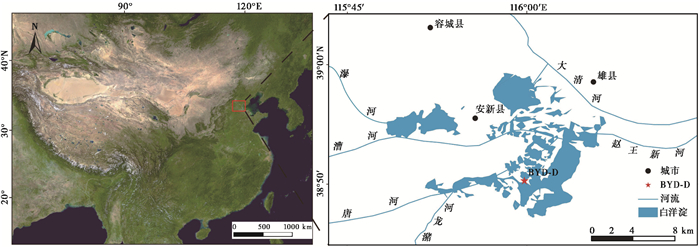
1 研究区概况白洋淀位于华北平原中部(38°43′~39°02′N,115°38′~116°07′E),是华北平原最大的淡水湖泊,总面积366km2,由太行山东麓永定河与滹沱河冲积扇交汇处的前缘低洼区汇水形成,最大水深为5m,主体位于安新县境内(图 1)。瀑河、唐河、漕河、潴龙河等从北、西、南三面入淀。年平均气温6.8~12.7℃,年平均降水量552.3mm,属于暖温带大陆性季风气候。本地区因人类开发历史悠久,原始植被已破坏殆尽,仅太行山山区还保存一定的次生林植被。乔木主要为杨属(Populus)、柳属(Salix)、榆属(Ulmus)、槐属(Sophora)和臭椿属(Ailanthus)等;湖边和湖内台地生长着芦苇(Phragmites communis),湖中生长着香蒲属(Typha)、狐尾藻属(Myriophyllum)、荇菜属(Nymphoides)和眼子菜属(Potamogeton)等植物;湖区人工种植了小麦(Triticum aestivum)、玉米(Zea mays)等农作物[35]。
|
图 1 研究区地理位置及白洋淀BYD-D钻孔位置 Fig. 1 Geographical position of study area and BYD-D drill position in the Baiyangdian Lake |
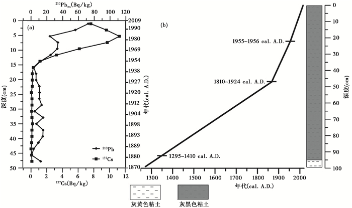
2016年4月在安新县端村(38°50′15.851″N,115°59′43.018″E)附近的白洋淀,选择未经清淤、人类活动扰动较少的区域打钻(BYD-D),海拔7.97m,水深2m,取样深度99cm。钻孔岩性特征变化不大,99~96cm以灰黄色粘土沉积为主;96~1cm以灰黑色粘土沉积为主,富含小螺壳、炭屑和植物残体。每1cm取一个样品,共取得99个样品。为了得到整个钻孔的年代,分别在钻孔的22cm、47cm和92cm处,选取3个样品进行AMS-14C测年。AMS-14C测年在美国Beta实验室完成。测年结果详见表 1及图 2。
| 表 1 白洋淀BYD-D钻孔AMS-14C测年数据 Table 1 Results of AMS-14C dating in the BYD-D drilling of Baiyangdian Lake |
|
图 2 白洋淀210Pb和137Cs比活度分布(a)(引自Guo等[45])以及BYD-D钻孔深度、年代及岩性图(b) Fig. 2 (a) 210Pb and 137Cs specific activity distribution from Baiyangdian Lake(cited from Guo et al. [45]); (b)Lithology and depth-age in the BYD-D drilling of Baiyangdian Lake |
粒度测试在河北师范大学资源与环境科学学院粒度分析实验室完成,使用英国马尔文公司生产的Malvern Mastersizer 3000型激光粒度仪进行实验相关操作。机器测量范围为0~3500μm,重复测量误差小于2 %。测量时使用一次性塑料滴管吸取搅拌均匀的样品,加至遮光度在10 % ~15 %之间,测量3次并取其平均值作为最终结果。为了更好的指示人类活动的强度,选择对人类活动指示性较强的磷(P)元素进行含量分析[38],该实验在南京师范大学环境演变与生态建设重点实验室完成。土壤含水率的测量是通过烘干前的样品质量减去烘干后的质量除以烘干前的质量计算得来。
2.3 孢粉和炭屑分析实验室孢粉提取采用常规的HCl-NaOH-HF处理法[39],化学处理前每个样品中加入一粒石松孢子片(27637±563粒)做指示剂,以计算孢粉浓度。孢粉鉴定与统计在400倍Imager A2蔡司光学显微镜下完成。每个样品鉴定统计花粉400粒以上。孢粉鉴定主要参考《中国植物花粉形态》[40]、《中国第四纪孢粉图鉴》[41]和保存在河北师范大学资源与环境科学学院环境演变与生态建设重点实验室的现代孢粉标本。为了区分农作物禾本科与非农作物禾本科花粉,根据前人研究结果[42],将禾本科(Poaceae)花粉划分为≥35μm和 < 35μm两组,≥35μm的禾本科花粉代表农作物。炭屑统计与孢粉鉴定同时进行,炭屑统计根据前人研究结果,按最长轴长度将其分为10~50μm、50~100μm和>100μm这3个等级统计[43],每个样品统计炭屑500粒以上。在统计炭屑的同时统计出石松孢子个数,以计算炭屑的浓度。
2.4 主成分分析(PCA)为了更好区别不同花粉类型的生态意义,对花粉百分比进行了主成分分析。选择花粉平均百分比含量在1 %以上或多数在1 %以上的花粉类型,整个钻孔99个样品中共得到16种花粉类型。样品分析采用Canoco 5软件完成,其基本步骤首先进行DCA(Detrended Correspondence Analysis)分析,第一主轴的梯度长度为1.2,小于2.0,表明白洋淀钻孔花粉组合和环境变量之间主要呈线性关系,适用于主成分分析法(简称PCA方法)[44]。
3 结果与分析 3.1 年代结果分析白洋淀BYD-D钻孔不同深度的3个年代样品测定结果见表 1和图 2,其中BYD-D022和BYD-D047两个样品的测年结果与Guo等[45]在白洋淀邻近地区同深度的137Cs和210Pb的测年结果较一致。测年数据采用BetaCal3.9计算机程序软件进行校准[46],根据已有的测年数据和沉积速率按照内插和外推法得到每个样品的年龄,该钻孔最底部年龄约为1270cal.A.D.。
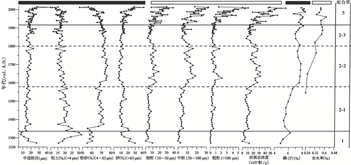
3.2 粒度及化学元素分析粒度分析结果表明,沉积物总体以粉砂(4~63μm)为主,含量多在50 % ~80 %之间,粘土(< 4μm)和砂(>63μm)的平均含量差别不大,分别约17.8 %和13.9 %,中值粒径平均为18.2μm,钻孔沉积物粒度总体较细,连续性好。化学元素磷(P)含量总体较高,且波动剧烈,多高于7 % (4.9 % ~8.4 %)。根据沉积物整体粒度特征与变化情况,结合磷(P)的变化自下而上划分为3个带,5个亚带(图 3):
|
图 3 白洋淀BYD-D钻孔粒度、炭屑、磷(P)和含水率曲线图 Fig. 3 Grain size, charcoal concentration, phosphorus (P) and rate of water content curve in the BYD-D drilling of Baiyangdian Lake |
带1 (99~94cm,约1340A.D.):本带99~96cm以灰黄色粘土为主,95~94cm以灰黑色粘土为主;中值粒径平均14.5μm(7.6~26.7μm),粉砂含量平均58.6 % (54.9 % ~61.3 %),均为整个钻孔最低值;粘土含量多在20 %以上(15.4 % ~31.5 %)、砂含量平均18.3 % (10.1 % ~29.7 %),均为钻孔最高值。磷(P)含量平均为5.5 %,为整个钻孔最低值。
带2 (93~31cm,1340~1920A.D.):本带以灰黑色粘土为主;中值粒径较带1明显变粗,平均17.1μm;粘土含量为17.8 % (11.6 % ~25.0 %),砂含量多低于10 % (6.2 % ~19.6 %),均较带1明显下降;粉砂含量多高于70 % (55.4 % ~76.6 %),较带1明显上升,为整个钻孔最高值。磷(P)含量多高于7 % (5.3 % ~8.1 %)较带1明显增加。但不同阶段粒径和磷含量存在较明显的波动,可将该带划分为3个子阶段或亚带:
带2-1 (93~73cm,1340~1580A.D.):该段粉砂含量(平均67.7 %)为带2最低值;粘土含量(平均20.1 %)为带2最高值,砂含量平均为12.2 %。磷(P)含量平均为5.9 %。
带2-2 (72~53cm,1580~1800A.D.):本亚带粘土(平均17.4 %)及砂(平均9.4 %)含量较带2-1下降;粉砂含量(平均73.2 %)较带2-1明显上升,并达到钻孔最高值。磷(P)含量(平均7.5 %)较带2-1明显增加。
带2-3 (52~31cm,1800~1920A.D.):本亚带粘土(平均16 %)和粉砂(平均71.6 %)含量均较带2- 2有所下降。砂(平均12.4 %)含量比带2-2有所上升。磷(P)含量(7.4 %)较带2-2略有减少。
带3 (30~0cm,1920A.D.至今):本带中值粒径较带2变粗,平均21.4μm(12.9~44.1μm),为整个钻孔最高值;粉砂含量(平均65.2 %)较带2有所下降,砂(平均18.2 %)含量明显高于带2,但低于带1。磷(P)含量(7.8 %)较带2明显增加,并达到钻孔最高值。
3.3 BYD-D钻孔孢粉分析白洋淀BYD-D钻孔99个孢粉样品共鉴定出67个孢粉类型,其中包括14种乔木、9种灌木、39种草本和5种蕨类孢子。其中常见的乔木花粉类型包括松属(Pinus)、栎属(Quercus)、榆属(Ulmus)、桦木属(Betula)、胡桃属(Juglans)等;灌木花粉类型有绣线菊属(Spiraea)、胡颓子属(Elaeagnus)、蔷薇科(Rosaceae)等;草本花粉主要有蒿属(Artemisia)、藜科(Chenopodiaceae)、菊科(Asteraceae)、十字花科(Brassicaceae)、荨麻属(Urtica)、葎草属(Humulus)、苍耳属(Xanthium)、禾本科(Poaceae)(< 35μm)、莎草科(Cyperaceae);水生花粉主要有狐尾藻属(Myriophyllum)、荇菜属(Nymphoides)、香蒲属(Typha)等;农作物花粉(禾本科≥35μm);蕨类孢子以单缝孢(Monolete)、三缝孢(Triletes)、卷柏科(Selaginellaceae)、水龙骨科(Polypodiaceae)为主。
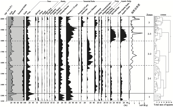
陆生植物孢粉百分比计算以鉴定的所有陆生植物孢粉总数为基数,水生植物科属百分比计算以鉴定的所有植物孢粉数为基数。根据花粉组合特征变化,结合孢粉浓度的变化情况,使用CONISS软件对花粉百分比数据进行有序聚类分析,将白洋淀BYD-D钻孔自下而上划分为3个孢粉组合带,5个亚带(图 4):
|
图 4 白洋淀BYD-D钻孔孢粉百分比和总浓度图 Fig. 4 Pollen percentage and total concentration in the BYD-D drilling of Baiyangdian Lake |
孢粉带1 (99~94cm,约1340A.D.):本带孢粉浓度(216粒/g)为整个钻孔最低值。孢粉组合中乔木花粉含量多在25 %以上(11.4 % ~52.3 %),其中松属花粉含量多在20 %以上,阔叶乔木含量约5 %,以榆属(3.3 %)为主;草本植物花粉中以藜科(平均25.7 %)和禾本科30.1 % (14.3 % ~45.5 %)花粉含量为主,湿生植物莎草科花粉含量为0.8 %,水生植物狐尾藻属花粉含量平均6.4 % (0~12.2 %);其余还出现少量蕨类植物孢子(平均6.2 %)和灌木植物花粉(平均1.5 %)。
孢粉带2 (93~31cm,1340~1920A.D.):孢粉浓度比带1明显提高,平均5194粒/g。乔木花粉含量较带1明显降低,多低于20 % (6.2 % ~38.1 %),其中以松属(14.8 %)花粉含量明显减少为主,阔叶树花粉(平均4 %)含量也略有降低;藜科花粉含量存在明显波动,多数在20 %以上(5.7 % ~34.2 %),荨麻属和葎草属花粉含量(平均7.8 %)增加明显,个别时段可达30 %以上;禾本科(≥35μm)花粉出现并达到2 %左右,但不同时段孢粉组合又存在明显差异,可将此阶段划分为3个亚带:
孢粉带2-1 (93~73cm,1340~1580A.D.):孢粉浓度与带1相比明显增加,在带2中为最低值(1998粒/g)。松属花粉含量多在20 %以上,个别阶段达到30 %以上,与带1相比无明显变化;藜科花粉含量多在20 %以下(8.3 % ~34.2 %),禾本科(< 35μm)花粉含量多在20 %以上,最高到40 %,莎草科花粉含量平均7.2 % (1.3 % ~19.1 %),菊科、荨麻属和葎草属花粉含量在5 %左右;禾本科(≥ 35μm)含量和浓度分别为0.5 %和20粒/g。
孢粉带2-2 (72~53cm,1580~1800A.D.):孢粉浓度明显上升,达6414粒/g。孢粉组合中松属花粉含量较带2-1明显降低,多在15 %以下,在约1650A.D.的云杉属(Picea)花粉含量为5 %左右,为整个钻孔最高值;藜科21.8 % (14.1 % ~27.1 %)花粉含量较带2-1明显增加,荨麻属和葎草属含量增加明显,多在20 %以上,最高为40 %,达到钻孔最高值,水生植物狐尾藻属(1.4 %)、禾本科(< 35μm)(14.2 %)花粉含量均为整个钻孔中最低;禾本科(≥35μm)花粉百分比和浓度均达到钻孔最高,为3.5 % (0.9 % ~7.7 %)和195粒/g。
孢粉带2-3 (52~31cm,1800~1920A.D.):本带孢粉浓度继续上升,达7135粒/g。孢粉组合中松属(多在10 %以下)和藜科(多低于10 %)花粉含量达到整个钻孔最低,禾本科(< 35μm)花粉含量多在40 %以上,最高可达58 %;湿生的莎草科花粉含量(多高于10 %)和狐尾藻属花粉含量(多在30 %以上)为整个钻孔最高值;禾本科(≥35μm)百分比(2.4 %)和浓度(124粒/g)均较带2-2略有降低。
孢粉带3 (30~0cm,1920A.D.至今):本带孢粉浓度继续上升,并达到最高值(7540粒/g)。乔木花粉含量较带2明显上升,多在25 %以上,最高达37 %,其中松属(多在20 %以上)和阔叶树(8 %)花粉含量均较带2明显增加;藜科(16.4 %)和菊科(10.5 %)花粉含量较带2明显增加;但禾本科(< 35μm)19.2 % (6.5 % ~67.4 %)、狐尾藻属(2 %左右)和香蒲科(2 %)花粉含量均较带2明显下降;禾本科(≥35μm)花粉含量(1.3 %)和浓度(110粒/g)总体上均较带2略有降低,但后期又明显增加,百分比含量可达3 %左右。
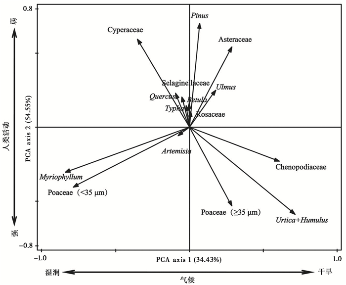
3.4 主成分分析(PCA)为更好了解白洋淀钻孔主要花粉类型的指示意义,对白洋淀BYD-D钻孔百分比含量高于1 %的16个花粉类型(松属、榆属、栎属、桦木属、蔷薇科、蒿属、藜科、禾本科(< 35μm)、禾本科(≥35μm)、菊科、香蒲科、莎草科、狐尾藻属、荨麻属、葎草属和中华卷柏)进行主成分分析,结果显示,第一和第二主成分共解释了所有变量54.55 %。如图 5所示,第一主成分轴(PCA axis 1)正值方向花粉类型主要以喜干的藜科、荨麻属、葎草属和菊科为主,负值方向主要以喜湿狐尾藻属、禾本科和莎草科为主,表明第一主成分主要反映湿度的变化,正值表示干旱,负值表示湿润;第二主成分轴(PCA axis 2)正值方向主要以木本植物松属、栎属和蔷薇科为主,负值方向主要以伴人植物藜科、荨麻葎草属和农作物禾本科(≥ 35μm)为主[47],表明第二主成分主要反映人类活动强度变化。正值表示人类活动相对较弱,负值表示人类活动相对较强。
|
图 5 白洋淀地区主要花粉类型的主成分分析(PCA)结果 Fig. 5 Principal Component Analysis(PCA)results for major pollen types in the Baiyangdian area |
炭屑分析结果显示白洋淀地区钻孔炭屑浓度含量高,平均22×103粒/g(1.7×103~76.8×103粒/g),主要以细粒和中粒炭屑为主,根据炭屑变化情况,结合孢粉组合自下而上划分为3个带,5个亚带(图 3):
带1 (99~94cm,约1340A.D.):炭屑总浓度4×10³粒/g(2×103~12×103粒/g),细粒炭屑浓度3×103粒/g(1×103~10×103粒/g),中粒炭屑浓度1×103粒/g(0~3×103粒/g),粗粒炭屑浓度33粒/g(22~127粒/g)均为钻孔最低值。
带2 (93~31cm,1340~1920A.D.):炭屑总浓度、细粒、中粒和粗粒浓度均明显上升,分别15×103粒/g、7×103粒/g、8×103粒/g和570粒/g,但不同阶段又存在明显差异,将其划分为3个子阶段:
带2-1 (93~73cm,1340~1580A.D.):炭屑总浓度9×10³粒/g,细粒浓度5×103粒/g,中粒浓度4×103粒/g和粗粒浓度363粒/g。
带2-2 (72~53cm,1580~1800A.D.):炭屑总浓度为23×103粒/g,细粒浓度为11×103粒/g,中粒浓度为12×103粒/g,粗粒浓度为799粒/g,均较带2-1明显增加并达到小冰期时期最高值。
带2-3 (52~31cm,1800~1920A.D.):炭屑总浓度(14×103粒/g)、细粒浓度为(7×103粒/g),中粒浓度(7×103粒/g)和粗粒浓度(548粒/g)均较带2-2明显降低。
带3 (30~0cm,1920A.D.至今):炭屑总浓度(40×103粒/g)、细粒浓度(19×103粒/g)、中粒浓度(18×103粒/g)和粗粒浓度(3×103粒/g)均较带2明显上升,达到钻孔最高值。
4 讨论 4.1 白洋淀湖泊沉积速率的变化分析沉积速率主要受重力、沉积物及流体动力环境相互作用的影响,在短期的湖泊沉积速率中主要反映现代沉积动力以及水体与沉积物的交换过程[48]。根据AMS-14C测年结果,近几百年来白洋淀沉积速率经历了一个由慢到快的变化过程,大致可分为3个阶段:1870A.D.以前沉积速率较慢,平均为0.09cm/a;1870A.D.以后沉积速率明显加快,平均为0.28cm/a;到1950A.D.以后沉积速率更快,为0.37cm/a。白洋淀沉积速率变化与湖区周围环境的改变及人类活动的增强密切相关:一方面,1870A.D.以后沉积速率变快可能与距离地表较近,土壤含水率(35 %以上)较1870A.D.以前含水率(25 %左右)增高(图 3),土壤没有得到压实有关;另一方面,还有可能与气候和人类活动有关。1870A.D.以前,孢粉指示气候总体偏干旱,降水减少,导致河流携带泥砂能力减小,砂含量减少,沉积物粒度较细,沉积速率偏慢。1870~1950A.D.乔木花粉处于低值,沉积物颗粒变粗,沉积速率加快,这可能是战争对华北地区森林资源造成了严重的破坏,使中国森林资源和森林覆盖率降到最低水平,导致土壤侵蚀加速[49]。1950A.D.以后尽管乔木花粉含量明显增加,有一定的森林面积增加,但粒度明显变粗,可能与人类活动增强有关。葛全胜和戴君虎[50]依据国家统计局数据得出,建国以后华北地区耕地面积(22.9 %)和垦殖率(40 %)长期居高不下,农业活动较强,这可能是影响沉积速率变快的一个主要因素。
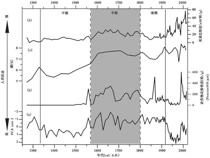
4.2 华北平原小冰期植被演替与人类活动强度过去人类活动及其环境变化是全球变化研究的热点问题[3]。小冰期以来植被变化受到人类活动的强烈影响,但区域植被整体上仍受气候条件制约,因此孢粉谱反映了区域植被及人类活动的共同特征[47, 51~53]。本研究孢粉组合中松属花粉含量多低于30 %,阔叶树花粉含量多在5 %左右,显示小冰期研究区周围不存在大面积的森林,但有稀疏的树木存在,荨麻属和葎草属等伴人植物花粉含量不同时期存在变化,狐尾藻属等水生植物花粉在不同时期也存在差异,显示水体曾发生变化(图 6)。
|
图 6 白洋淀BYD-D钻孔 (a)PCA axis 2、(b)农作物花粉浓度(Poaceae≥35μm)、(c)磷(P)含量和(d)炭屑总浓度的对应关系 Fig. 6 Relations between (a) PCA axis 2, (b)crop pollen concentration(Poaceae≥35μm), (c)phosphorus (P) content, and (d)total charcoal concentration in the BYD-D drilling of Baiyangdian Lake |
1580A.D.以前,松属花粉含量多在25 %以上,个别时段超过40 %,榆属、栎属等阔叶树花粉含量在5 %左右。李文漪和姚祖驹[54]通过对花粉类型与植被定量关系的研究认为,松属花粉容易被高估,松属花粉在30 %以上,才有可能存在松林,榆属、栎属等阔叶树花粉含量在5 %左右;李月丛等[55]对阔叶树表土花粉研究中认为,榆属、栎属等阔叶树花粉均容易被低估,含量一般在1 %以上时,研究区周围存在该植物的可能性很大。据此推测研究区该时期应以森林草地为主;此外,与人类活动有关的炭屑浓度及农作物(禾本科≥35μm)花粉含量(图 6b)和磷(P)(图 6c)均最低,说明小冰期早期研究区农业活动强度相对较弱。这与历史记载具有较好一致性,比如,邢嘉明和王会昌[56]研究认为,明朝初年华北燕山、太行山的森林覆被状况较以前变化较小;此外明朝初年山东、河北、河南等地起义不断,明洪武后又发生了“靖难之役”,导致华北平原人口较少,农业活动较弱[57]。
1580~1800A.D.松属花粉含量与1580A.D.以前相比明显下降,多低于15 %,最低仅5 %,草本植物花粉占优,表明森林覆盖率下降,以草地景观为主。据历史文献记载,该时期由于气候变冷,木炭需求量增多,永定河上游森林植被进一步破坏[58]。该时期炭屑总浓度、细粒、中粒和粗粒均达到最高,尤其粗粒炭屑,一般认为,粒径>50μm的炭屑指示地方性火灾的发生[59],表明该时期地方性火灾经常发生,火灾的发生固然与当时干旱的气候有一定的关系,但从孢粉研究来看,人类活动对火灾也有一定贡献,荨麻属和葎草属等伴人植物花粉含量、与农业活动相关的磷(P)含量和农作物(禾本科≥ 35μm)花粉含量均达到最高值,表明人类活动较强。该阶段第二主成分轴(PCA axis 2)得分值较之前明显偏负,也显示人类活动强度增加(图 6a)。该阶段人类活动较强还与湖泊面积收缩有关。该时期沉积物颗粒变细,砂含量减少,表明此阶段河流注入减少,湖面处于收缩的过程。湖泊收缩,使得湖泊周围原有湿地更容易被改造为农田,而且成本低廉。该时期人口资料表明,由于清朝初年,政治稳定,人口从1661年的1亿增加到1800年的3亿,人口的增加导致人类为了生存不得不扩大耕地面积,以养活更多人口[60~61]。
1800~1920A.D.该时期荨麻属和葎草属等伴人植物花粉含量、农作物(禾本科≥35μm)花粉、炭屑浓度和磷(P)含量均较上一时期降低,但第二主成分轴(PCA axis 2)值显示与1580~1800A. D时期基本持平,表明人类活动强度较小冰期中期持平或略有降低。略有降低的原因主要与湖泊扩张有关,孢粉分析显示,该时期狐尾藻属和荇菜属等水生植物花粉明显增加,多高于30 %,砂含量增加,河流搬运能力增强,综合指示水位升高,湖泊面积扩大。湖泊面积的扩大使得部分农田被淹,耕地减少,但该时期人口数量并没有减少,因此第二主成分轴(PCA axis 2)得分值显示与1580~1800A.D.持平。
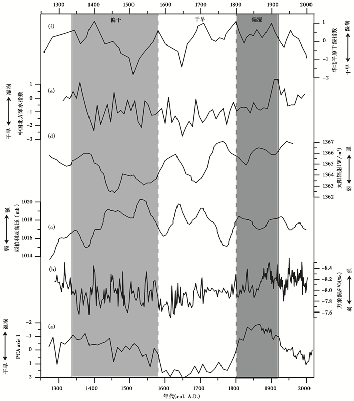
4.3 华北平原小冰期干湿变化特征及形成机制华北平原小冰期总体较寒冷已达成共识[8~9],但干湿变化特征存在争议[27, 29]。本研究通过孢粉、粒度等多指标分析发现:小冰期期间沉积物粒度总体较细、孢粉组合主要以喜干的藜科、蒿属、荨麻属和葎草属花粉为主,表明小冰期气候总体干旱,但不同阶段又存在明显差异,可将小冰期划分为3个阶段(图 7):
|
图 7 白洋淀BYD-D钻孔小冰期干湿变化与区域古气候记录的对应关系 (a)PCA axis 1;(b)万象洞δ18O[4];(c)西伯利亚高压[63];(d)太阳辐射[64];(e)中国北方干湿指数[16];(f)华北平原干湿指数[62] Fig. 7 Relations between dry-wet changes and paleoclimatic records of the Little Ice Age in the BYD-D drilling of Baiyangdian Lake. (a)PCA axis 1; (b)Wanxiangdong caveδ18O[4]; (c)Siberia High[63]; (d)Solar Radiation[64]; (e)Dry-wet index of Northern China[16]; (f)Dry-wet index of North China Plain[62] |
小冰期早期(1340~1580A.D.):孢粉组合中喜干的藜科花粉含量逐渐增加到20 %左右,湿生草本植物莎草科、狐尾藻属、荇菜属等花粉含量偏低或不出现,第一主成分轴(PCA axis 1)得分值多数在0~1之间,表明该时期气候偏干。关于小冰期早期气候偏干已有较多研究:Zheng等[62]通过旱涝次数重建华北平原干湿指数认为,1340~1370A.D.和1420~1520A.D.气候干旱;Tan等[16](图 7e)和Li等[11]重建了中国北方降水指数认为此阶段气候偏干。
小冰期中期(1580~1800A.D.):该时期喜干的藜科、荨麻属和葎草属花粉含量较小冰期早期明显增加,均在20 %以上;湿生植物如狐尾藻属、荇菜属等花粉少见,莎草科花粉含量最低,第一主成分轴(PCA axis 1)得分值明显升高至1~2之间,表明此阶段气候较早期更为干旱。该时期的干旱在华北地区[28~29]、东北地区[30]、西北季风区[65]等均有记录;而中国南方地区[22, 62]等较多的记录指示小冰期气候比较湿润,但在17世纪中期出现几次干旱的波动。
小冰期晚期(1800~1920A.D.):孢粉组合中水生植物狐尾藻属、香蒲科和湿生草本植物禾本科(< 35μm)、莎草科花粉含量均较小冰期中期明显增加,达80 %以上,喜干的藜科花粉含量明显降低,多低于10 %,第一主成分轴(PCA axis 1)得分值负偏,指示气候变湿。该阶段偏湿的气候在历史文献记录多有显示,清朝后期(1750~1910A.D.)洪涝灾害发生频率比前期增多,旱灾减少,洪涝灾害证实了小冰期后期降水增多[31, 34]。Zheng等[62](图 7f)通过旱涝指数揭示了华北平原1700A.D.以后气候变湿; Tan等[16](图 7e)通过北方石笋和历史文献研究认为,1850A.D.以后气候变湿。
华北平原小冰期内部干湿变化受多种因素的影响[14, 28],本研究通过对比分析认为,小冰期的干湿变化机制可能受到太阳辐射和东亚季风的共同影响(图 7)。小冰期早期和中期气候干旱,对应太阳活动的斯波勒极小期(Sprer Minimum)和蒙德极小期(Maunder Minimum)及夏季风相对较弱时期[64],对应西伯利亚高压相对最强的时期[63]。数值模拟显示,太阳辐射的微小变化会导致地球表面温度的变化[66~67],由于陆地和海洋之间的比热容不同,进而导致地球气候系统的变化[68]。研究显示,在东亚季风区,如果太阳辐射增强,将会影响东亚大陆和北太平洋热对比增强,导致西太平洋副热带高压(副高)位置向北转移[69~70],夏季风雨带也将进一步北上和向西延长,同时冬季风(西伯利亚高压)减弱并向北撤退,导致东亚夏季风强度增强[70~71]。反之,太阳辐射降低,西太平洋副热带高压(副高)位置长期停留在南方,东亚夏季风减弱,东亚冬季风(西伯利亚高压)增强[72~73]。该时段利用10Be重建的小冰期太阳辐射处于最弱的时期[64],与中国北部季风区万象洞[4](图 7b)、和尚洞[74]记录的δ18O偏正相对应,指示夏季风减弱;而小龙湾湖[30]、石花洞[28]、格陵兰冰芯[63]记录西伯利亚高压增强(图 7c)。小冰期晚期较多研究显示,太阳辐射逐渐增强[64],东亚夏季风增强[4, 74],东亚冬季风减弱[63](图 7),因此导致小冰期后期气候变湿。
5 结论本文在3个AMS-14C测年的基础上,通过99个样品的孢粉、炭屑、粒度等指标高分辨率地重建了白洋淀地区小冰期以来的气候干湿变化特征及与人类活动强度的关系。结果如下:
(1) 白洋淀地区小冰期孢粉组合以草本为主,乔木花粉含量多低于30 %,但不同时期存在变化,早期乔木花粉可达20 % ~30 %,主要以森林草地景观为主,中期和晚期乔木花粉含量低于15 %,主要以草地景观为主,森林面积逐渐减少。
(2) 小冰期时期气候总体寒冷,但存在干湿变化,小冰期早期(1340~1580A.D.)较为干旱,孢粉组合中喜干的藜科花粉含量逐渐增加到20 %左右,莎草科花粉含量降低,显示湿度较之前逐渐减小;小冰期中期(1580~1800A.D.)最为干旱,喜干的藜科、荨麻属和葎草属花粉含量均为全钻孔最高,均在20 %以上;湿生植物花粉含量少见;小冰期晚期(1800~1920A.D.)气候略转湿润,孢粉组合中水生植物狐尾藻属、香蒲科和湿生莎草科花粉含量均达剖面最高,喜干的藜科花粉含量明显降低,多低于10 %。
(3) 小冰期中期干旱时期,人类活动强度最高,农作物(禾本科≥35μm)花粉、荨麻属和葎草属等伴人植物花粉和磷(P)含量均达小冰期最高。小冰期晚期人类活动略有降低,与气候变湿、湖泊扩张有关。
致谢: 感谢审稿老师建设性的修改意见,使文章得以完善!
| [1] |
Tkachuck R D. The Little Ice Age[J]. Origins, 1983, 10(2): 51-65. |
| [2] |
Mann M E, Zhang Z H, Rutherford S, et al. Global signatures and dynamical origins of the Little Ice Age and Medieval Climate Anomaly[J]. Science, 2009, 326(5957): 1256-1260. DOI:10.1126/science.1177303 |
| [3] |
Kulkarni C, Peteet D M, Boger R. The Little Ice Age and human- environmental interactions in the Central Balkans:Insights from a new Serbian paleorecord[J]. Quaternary International, 2018, 482: 13-26. DOI:10.1016/j.quaint.2018.04.035 |
| [4] |
Zhang P Z, Cheng H, Edwards R L, et al. A test of climate, sun, and culture relationships from an 1810-year Chinese cave record[J]. Science, 2008, 322(5903): 940-942. DOI:10.1126/science.1163965 |
| [5] |
李康康, 秦小光, 张磊, 等. 罗布泊(楼兰)地区1260-1450 A.D.期间的绿洲环境和人类活动[J]. 第四纪研究, 2018, 38(3): 720-731. Li Kangkang, Qin Xiaoguang, Zhang Lei, et al. The ancient oasis and human activity in Lop Nur (Loulan) region during 1260-1450 A.D.[J]. Quaternary Science, 2018, 38(3): 720-731. |
| [6] |
马春梅, 王冰翎, 刘泽雨, 等. 浙江田螺山遗址区孢粉学记录的中全新世植被、环境和人类活动初步研究[J]. 第四纪研究, 2018, 38(5): 1304-1312. Ma Chunmei, Wang Bingling, Liu Zeyu, et al. A preliminary study on vegetation, environment and human activity of pollen records during Middle-Late Holocene in Tianluoshan site, Ningshao Plain[J]. Quaternary Sciences, 2018, 38(5): 1304-1312. |
| [7] |
Cui A N, Ma C M, Zhao L, et al. Pollen records of the Little Ice Age humidity flip in the middle Yangtze River catchment[J]. Quaternary Science Reviews, 2018, 193: 43-53. DOI:10.1016/j.quascirev.2018.06.015 |
| [8] |
竺可桢. 中国近五千年来气候变迁的初步研究[J]. 中国科学, 1973(2): 168-189. Chu Kochen. A preliminary study on climate change in China in the past 5, 000 years[J]. Science in China, 1973(2): 168-189. |
| [9] |
Tan M, Liu T S, Hou J Z, et al. Cyclic rapid warming on centennial-scale revealed by a 2650-year stalagmite record of warm season temperature[J]. Geophysical Research Letters, 2003, 30(12): 19-11. |
| [10] |
Müller C. Bi-decadal climate reconstruction derived from a 1200-year long pollen record from the NE Qinghai-Tibet Plateau and its implications for discussion of the Late Holocene environmental dynamics[J]. Quaternary International, 2017, 444(1): 1-10. |
| [11] |
Li J Y, Dodson J, Yan H, et al. Quantifying climatic variability in monsoonal Northern China over the last 2200 years and its role in driving Chinese dynastic changes[J]. Quaternary Science Reviews, 2017, 159: 35-46. DOI:10.1016/j.quascirev.2017.01.009 |
| [12] |
覃军干, 张新荣, 张强, 等. 近1000年以来气候波动在广西桂北地区沉积物中的记录[J]. 第四纪研究, 2016, 36(2): 268-277. Qin Jungan, Zhang Xinrong, Zhang Qiang, et al. Climate oscillations recorded in the sediment from north Guilin, Guangxi during the past 1000 years[J]. Quaternary Sciences, 2016, 36(2): 268-277. |
| [13] |
Bard E, Raisbeck G, Yiou F, et al. Solar irradiance during the last 1200 years based on cosmogenic nuclides[J]. Tellus, Series B:Chemical and Physical Meteorology, 2000, 52(3): 985-992. DOI:10.3402/tellusb.v52i3.17080 |
| [14] |
Chen J H, Chen F H, Feng S, et al. Hydroclimatic changes in China and surroundings during the Medieval Climate Anomaly and Little Ice Age:Spatial patterns and possible mechanisms[J]. Quaternary Science Reviews, 2015, 107: 98-111. DOI:10.1016/j.quascirev.2014.10.012 |
| [15] |
Sigl M, Winstrup M, Mcconnell J R, et al. Timing and climate forcing of volcanic eruptions for the past 2, 500 years[J]. Nature, 2015, 523(7562): 543. DOI:10.1038/nature14565 |
| [16] |
Tan L C, Cai Y J, An Z S, et al. Climate patterns in north central China during the last 1800 yr and its possible driving force[J]. Climate of the Past Discussions, 2011, 7(2): 685-692. |
| [17] |
Tan L C, Cai Y J, An Z S, et al. Centennial-to decadal-scale monsoon precipitation variability in the semi-humid region, Northern China during the last 1860 years:Records from stalagmites in Huangye cave[J]. The Holocene, 2011, 21(2): 287-296. DOI:10.1177/0959683610378880 |
| [18] |
李亮, 马春梅, 鹿化煜, 等. 江西中部玉华山沼泽泥炭记录的过去两千年气候变化初步研究[J]. 第四纪研究, 2017, 37(3): 548-559. Li Liang, Ma Chunmei, Lu Huayu, et al. A preliminary study of the climate change since 2 ka archived by a peat core from Yuhua Mountain in the middle Jiangxi Province[J]. Quaternary Sciences, 2017, 37(3): 548-559. |
| [19] |
周云鹏, 胡忠行, 张曼, 等. 浙江望东篛亚高山沼泽泥炭磁性特征及其环境意义[J]. 第四纪研究, 2017, 37(6): 1348-1356. Zhou Yunpeng, Hu Zhongxing, Zhang Man, et al. Magnetic properties of the Wangdongyang subalpine peatland in Zhejiang Province, Eastern China and its paleoenvironmental implications[J]. Quaternary Sciences, 2017, 37(6): 1348-1356. |
| [20] |
蒋文静, 赵侃, 陈仕涛, 等. 小冰期十年际尺度亚洲季风变化的四川黑竹沟洞石笋记录[J]. 第四纪研究, 2017, 37(1): 118-129. Jiang Wenjing, Zhao Kan, Chen Shitao, et al. Decadal climate oscillations during the Little Ice Age of stalagmite record from Heizhugou Cave, Sichuan[J]. Quaternary Sciences, 2017, 37(1): 118-129. |
| [21] |
Zhou X J, Zhao P, Liu G, et al. Characteristics of decadal- centennial-scale changes in East Asian summer monsoon circulation and precipitation during the Medieval Warm Period and Little Ice Age and in the present day[J]. Chinese Science Bulletin, 2011, 56(28-29): 3003-3013. DOI:10.1007/s11434-011-4651-4 |
| [22] |
Zeng Y, Chen J A, Zhu Z J, et al. The wet Little Ice Age recorded by sediments in Huguangyan Lake, tropical South China[J]. Quaternary International, 2012, 263(1): 55-62. |
| [23] |
任维鹤, 易桂田, 李泉. 中国东部季风区小冰期干湿变化及影响机制[J]. 安徽师范大学学报(自然科学版), 2017, 40(5): 479-483. Ren Weihe, Yi Guitian, Li Quan. Spatial patterns and possible mechanisms of hydroclimatic changes in Eastern China during the Little Ice Age[J]. Journal of Anhui Normal University (Natural Science), 2017, 40(5): 479-483. |
| [24] |
Zhang W C, Yan H, Liu C C, et al. Hydrological changes in Shuangchi Lake, Hainan Island, tropical China, during the Little Ice Age[J]. Quaternary International, 2018, 487: 54-60. DOI:10.1016/j.quaint.2017.09.007 |
| [25] |
Zheng J Y, Hao Z X, Zhang X Z, et al. Drought/flood spatial patterns in centennial cold and warm periods of the past 2000 years over Eastern China[J]. Chinese Science Bulletin, 2014, 59(30): 2964-2971. DOI:10.1360/N972014-00393 |
| [26] |
张娴, 邵晓华, 王涛. 中国小冰期气候研究综述[J]. 南京信息工程大学学报(自然科学版), 2013, 5(4): 317-325. Zhang Xian, Shao Xiaohua, Wang Tao. Regional climate characteristics in China during the Little Ice Age[J]. Journal of Nanjing University of Information Science and Technology(Natural Science Edition), 2013, 5(4): 317-325. |
| [27] |
郭盛乔, 石英, 杨丽娟, 等. 河北宁晋泊地区2600年来古气候变化研究[J]. 地质力学学报, 1999, 5(4): 75-81. Guo Shengqiao, Shi Ying, Yang Lijuan, et al. A study of paleoclimatic fluctuations in the last 2600 years in the Ningjin Lake area, Hebei Province[J]. Journal of Geomechanics, 1999, 5(4): 75-81. |
| [28] |
Hou J Z, Tan M, Cheng H, et al. Stable isotope records of plant cover change and monsoon variation in the past 2200 years:Evidence from laminated stalagmites in Beijing, China[J]. Boreas, 2003, 32(2): 304-313. DOI:10.1080/03009480310002000 |
| [29] |
Liu J B, Chen F H, Chen J H, et al. Humid Medieval Warm Period recorded by magnetic characteristics of sediments from Gonghai Lake, Shanxi, North China[J]. Chinese Science Bulletin, 2011, 56(23): 2464-2474. DOI:10.1007/s11434-011-4592-y |
| [30] |
Chu G Q, Sun Q, Wang X H, et al. A 1600 year multiproxy record of paleoclimatic change from varved sediments in Lake Xiaolongwan, Northeastern China[J]. Journal of Geophysical Research:Atmospheres, 2009, 114(114): 2191-2196. |
| [31] |
陈颖, 赵景波. 北京地区明代、清代干旱灾害与气候事件研究[J]. 干旱区资源与环境, 2011, 25(9): 176-182. Chen Ying, Zhao Jingbo. The draught disasters and climate events in Beijing in Ming and Qing Dynasty[J]. Journal of Arid Land Resources and Environment, 2011, 25(9): 176-182. |
| [32] |
葛全胜, 刘路路, 郑景云, 等. 过去千年太阳活动异常期的中国东部旱涝格局[J]. 地理学报, 2016, 71(5): 707-717. Ge Quansheng, Liu Lulu, Zheng Jingyun, et al. Spatial patterns of drought/flood over Eastern China in the periods of anomalous solar activity during the past millennium[J]. Acta Geographica Sinica, 2016, 71(5): 707-717. |
| [33] |
巩晓燕, 魏明建, 张玉华. 华北地区全新世气候时空变化特征研究述评[J]. 首都师范大学学报(自然科学版), 2006, 27(4): 73-78. Gong Xiaoyan, Wei Mingjian, Zhang Yuhua. General research on the spatio-temporal trait of climate change in North China in Holocene[J]. Journal of Capital Normal University (Natural Science Edition), 2006, 27(4): 73-78. DOI:10.3969/j.issn.1004-9398.2006.04.016 |
| [34] |
张德二, 刘月巍. 北京清代"晴雨录"降水记录的再研究——应用多因子回归方法重建北京(1724-1904年)降水量序列[J]. 第四纪研究, 2002, 22(3): 199-208. Zhang De'er, Liu Yuewei. A new approach to the reconstruction of temporal rainfall sequences from 1724-1904 Qing-Dynasty weather records for Beijing[J]. Quaternary Sciences, 2002, 22(3): 199-208. DOI:10.3321/j.issn:1001-7410.2002.03.002 |
| [35] |
许清海, 陈淑英, 孔昭宸, 等. 白洋淀地区全新世以来植被演替和气候变化初探[J]. 植物生态学与地植物学学报, 1988, 12(2): 65-73. Xu Qinghai, Chen Shuying, Kong Zhaochen, et al. Preliminary discussion of vegetation succession and climate change since the Holocene in the Baiyangdian Lake district[J]. Acta Phytoecologica et Geobotanica Sinica, 1988, 12(2): 65-73. |
| [36] |
申改慧, 丁国强, 阳小兰, 等. 白洋淀地区全新世以来的气候环境变化[J]. 第四纪研究, 2018, 38(3): 756-768. Shen Gaihui, Ding Guoqiang, Yang Xiaolan, et al. Holocene climate and environmental change in the Baiyangdian area[J]. Quaternary Sciences, 2018, 38(3): 756-768. |
| [37] |
郭超, 马玉贞, 胡彩莉, 等. 中国内陆区湖泊沉积所反映的全新世干湿变化[J]. 地理科学进展, 2014, 33(6): 786-798. Guo Chao, Ma Yuzhen, Hu Caili, et al. Holocene humidity changes in inland China inferred from lake sediments[J]. Progress in Geography, 2014, 33(6): 786-798. |
| [38] |
吴艳宏, 邴海健, 刘恩峰, 等. 龙感湖近百年来沉积物磷的时空分布特征及其人类活动影响[J]. 第四纪研究, 2010, 30(6): 1151-1155. Wu Yanhong, Bing Haijian, Liu Enfeng, et al. Spatial and temporal distribution of phosphorus in the sediments of Longgan Lake over the past century and its relation to human activities[J]. Quaternary Sciences, 2010, 30(6): 1151-1155. DOI:10.3969/j.issn.1001-7410.2010.06.11 |
| [39] |
Faegri K, Kaland P E, Krzywinski K, et al. Textbook of pollen analysis[J]. Journal of Biogeography, 1989, 12(12): 328. |
| [40] |
王伏雄, 钱南芬, 张玉龙, 等. 中国植物花粉形态[M]. 第二版. 北京: 科学出版社, 1995: 1-461. Wang Fuxiong, Qian Nanfen, Zhang Yulong, et al. Pollen Flora of China[M]. Second Edition. Beijing: Science Press, 1995: 1-461. |
| [41] |
唐领余, 毛礼米, 舒军武, 等. 中国第四纪孢粉图鉴[M]. 北京: 科学出版社, 2016: 1-601. Tang Lingyu, Mao Limi, Shu Junwu, et al. An Illustrated Handbook of Quaternary Pollen and Spores in China[M]. Beijing: Science Press, 2016: 1-601. |
| [42] |
蓝盛银, 徐珍秀. 植物花粉剥离观察扫描电镜图解[M]. 北京: 科学出版社, 1996: 1-134. Lan Shengyin, Xu Zhenxiu. Plant Pollen Stripping Observation Scanning Electron Microscope[M]. Beijing: Science Press, 1996: 1-134. |
| [43] |
李小强, 周新郢, 尚雪, 等. 黄土炭屑分级统计方法及其在火演化研究中的意义[J]. 湖泊科学, 2006, 18(5): 540-544. Li Xiaoqiang, Zhou Xinying, Shang Xue, et al. Different-(kPa/℃) size method of charcoal analysis in loss and its significance in the study of fire variation[J]. Journal of Lake Sciences, 2006, 18(5): 540-544. DOI:10.3321/j.issn:1003-5427.2006.05.017 |
| [44] |
Ter Braak C, Prentice C. A theory of gradient analysis[J]. Advances in Ecological Research, 1988, 18: 271-317. DOI:10.1016/S0065-2504(08)60183-X |
| [45] |
Guo W, Pei Y S, Yang Z F, et al. Historical changes in polycyclic aromatic hydrocarbons (PAHs) input in Lake Baiyangdian related to regional socio-economic development[J]. Journal of Hazardous Materials, 2011, 187(1-3): 441-449. DOI:10.1016/j.jhazmat.2011.01.052 |
| [46] |
Ramsey C B. Bayesian analysis of radiocarbon dates[J]. Radiocarbon, 2009, 51(1): 337-360. DOI:10.1017/S0033822200033865 |
| [47] |
李宜垠, 周力平, 崔海亭. 人类活动的孢粉指示体[J]. 科学通报, 2008, 53(9): 991-1002. Li Yiyin, Zhou Liping, Cui Haiting. Pollen indicator of human activity[J]. Chinese Science Bulletin, 2008, 53(9): 991-1002. DOI:10.3321/j.issn:0023-074X.2008.09.003 |
| [48] |
王小雷, 杨浩, 赵其国, 等. 云南滇池近现代沉积速率及气候干湿变化的粒度记录[J]. 地理研究, 2011, 30(1): 161-171. Wang Xiaolei, Yang Hao, Zhao Qiguo, et al. Modern sedimentation rates and dry-humid change inferred from grain size records in Dianchi Lake, Yunnan Province[J]. Geographical Research, 2011, 30(1): 161-171. |
| [49] |
王长富. 我国古、近代森林资源演变史的研究[J]. 林业经济, 1987, 1672-7789(1): 7-11. Wang Changfu. A study on the evolution history of forest resources in ancient and modern China[J]. Forestry Economics, 1987, 1672-7789(1): 7-11. |
| [50] |
葛全胜, 戴君虎. 20世纪前、中期中国农林土地利用变化及驱动因素分析[J]. 中国科学(D辑), 2005, 35(1): 54-63. Ge Quansheng, Dai Junhu. Analysis on the change and driving factors of China's agriculture and forestry land use in the early and middle period of the 20th century[J]. Science in China (Series D), 2005, 35(1): 54-63. |
| [51] |
Iversen J. The influence of prehistoric man on vegetation[J]. Danmarks Geologiske Undersgelse, 1949, 3(6): 1-25. |
| [52] |
郑邦, 周斌, 王可, 等. 晚全新世东海泥质区物源输入、源区植被变化及其影响因素:来自MD06- 3039A孔的正构烷烃记录[J]. 第四纪研究, 2018, 38(5): 1293-1303. Zheng Bang, Zhou Bin, Wang Ke, et al. Changes of provenance input and source vegetation changes and their impact factors since Late Holocene based on n-alkanes-records from core MD06-3039A in the muddy area of the East China Sea[J]. Quaternary Sciences, 2018, 38(5): 1293-1303. |
| [53] |
高鑫, 贾铁飞, 许清海, 等. 湖北中洲子牛轭湖最近70年孢粉-炭屑记录及其对气候和人类活动的响应[J]. 第四纪研究, 2016, 36(6): 1445-1455. Gao Xin, Jia Tiefei, Xu Qinghai, et al. Records of lacustrine sedimentology and pollen-charcoal assemblages responding to climate change and human activities in Zhongzhouzi Oxbow Lake, Hubei Province for about 70 years[J]. Quaternary Sciences, 2016, 36(6): 1445-1455. |
| [54] |
李文漪, 姚祖驹. 表土中松属花粉与植物间数量关系的研究[J]. 植物学报, 1990, 32(12): 943-950. Li Wenyi, Yao Zuju. A study on the quantitative relationship between Pinus in surface sample and Pinus vegetation[J]. Acta Botanica Sinica, 1990, 32(12): 943-950. |
| [55] |
李月丛, 许清海, 肖举乐, 等. 中国北方森林植被主要表土花粉类型对植被的指示性[J]. 第四纪研究, 2005, 25(5): 598-608. Li Yuecong, Xu Qinghai, Xiao Jule, et al. Indication of some major pollen taxa in surface samples to their parent plants of forest in Northern China[J]. Quaternary Sciences, 2005, 25(5): 598-608. DOI:10.3321/j.issn:1001-7410.2005.05.009 |
| [56] |
邢嘉明, 王会昌. 京津唐地区自然环境演变及区域开发过程[J]. 地理集刊, 1986(18): 1-20. Xing Jiaming, Wang Huichang. Natural environment evolution and regional development process in Beijing-Tianjin-Tangshan region[J]. Geographical Collection, 1986(18): 1-20. |
| [57] |
葛全胜. 中国历朝气候变化[M]. 北京: 科学出版社, 2011: 492-665. Ge Quansheng. Climate Change Through Every Chinese Dynasty[M]. Beijing: Science Press, 2011: 492-665. |
| [58] |
尹钧科.永定河中、上游流域森林植被的破坏[C]//历史地理(第19辑).上海: 上海人民出版社, 2003: 260-267. Yin Junke. Destruction of forest vegetation in the middle and upper reaches of the Yongding River[C]//Historical Geography (19th Series). Shanghai: Shanghai People's Publishing House, 2003: 260-267. |
| [59] |
Huang C C, Pang J L, Chen S E, et al. Charcoal records of fire history in the Holocene loess-soil sequences over the southern Loess Plateau of China[J]. Palaeogeography, Palaeoclimatology, Palaeoecology, 2006, 239(1-2): 28-44. DOI:10.1016/j.palaeo.2006.01.004 |
| [60] |
戴逸. 简明清史(第二册)[M]. 北京: 人民出版社, 1984: 1-327. Dai Yi. Concise Qing History(Volume 2)[M]. Beijing: People's Publishing House, 1984: 1-327. |
| [61] |
葛全胜, 戴君虎, 何凡能, 等. 过去300年中国部分省区耕地资源数量变化及驱动因素分析[J]. 自然科学进展, 2003, 13(8): 43-50+116. Ge Quansheng, Dai Junhu, He Fanneng, et al. Analysis on the change of the quantity of cultivated land resources and its driving factors in some provinces of China in the past 300 years[J]. Progress in Natural Science, 2003, 13(8): 43-50+116. |
| [62] |
Zheng J Y, Wang W C, Ge Q S, et al. Precipitation variability and extreme events in Eastern China during the past 1500 years[J]. Terrestrial Atmospheric & Oceanic Sciences, 2006, 17(3): 579-592. |
| [63] |
Meeker L D, Mayewski P A. A 1400-year high-resolution record of atmospheric circulation over the North Atlantic and Asia[J]. The Holocene, 2002, 12(3): 257-266. DOI:10.1191/0959683602hl542ft |
| [64] |
Bard E, Raisbeck G, Yiou F, et al. Solar irradiance during the last 1200 years based on cosmogenic nuclides[J]. Tellus B:Chemical and Physical Meteorology, 2000, 52(3): 985-992. DOI:10.3402/tellusb.v52i3.17080 |
| [65] |
Tan L C, Cai Y J, Yi L, et al. Precipitation variations of Longxi, northeast margin of Tibetan Plateau since AD 960 and their relationship with solar activity[J]. Climate of the Past, 2008, 4(1): 19-28. DOI:10.5194/cp-4-19-2008 |
| [66] |
Shindell D T, Schmidt G A, Mann M E, et al. Solar forcing of regional climate change during the Maunder Minimum[J]. Science, 2001, 294(5549): 2149-2152. DOI:10.1126/science.1064363 |
| [67] |
Wang Y, Cheng H, Edwards R L, et al. The Holocene Asian monsoon:Links to solar changes and North Atlantic climate[J]. Science, 2005, 308(5723): 854-857. DOI:10.1126/science.1106296 |
| [68] |
Haigh J D. The impact of solar variability on climate[J]. Science, 1996, 272(5264): 981-984. DOI:10.1126/science.272.5264.981 |
| [69] |
Zhao P, Zhu Y, Zhang R H. An Asian-Pacific teleconnection in summer tropospheric temperature and associated Asian climate variability[J]. Climate Dynamics, 2007, 29(2-3): 293-303. DOI:10.1007/s00382-007-0236-y |
| [70] |
王绍武, 黄建斌. 近千年中国东部夏季雨带位置的变化[J]. 气候变化研究进展, 2006, 2(3): 117-121+145. Wang Shaowu, Huang Jianbin. The variations of geographical latitude of rain belts in summer over Eastern China during the last millennium[J]. Advances in Climate Change Research, 2006, 2(3): 117-121+145. DOI:10.3969/j.issn.1673-1719.2006.03.005 |
| [71] |
Qian W H, Zhu Y F, Tang S Q. Reconstructed index of summer monsoon dry-wet modes in East Asia for the last millennium[J]. Chinese Science Bulletin, 2011, 56(28-29): 3019-3027. DOI:10.1007/s11434-011-4714-6 |
| [72] |
Xia D S, Jia J, Li G H, et al. Out-of-phase evolution between summer and winter East Asian monsoons during the Holocene as recorded by Chinese loess deposits[J]. Quaternary Research, 2014, 81(3): 500-507. DOI:10.1016/j.yqres.2013.11.002 |
| [73] |
Kang S, Wang X, Roberts H M, et al. Late Holocene anti-phase change in the East Asian summer and winter monsoons[J]. Quaternary Science Reviews, 2018, 188: 28-36. DOI:10.1016/j.quascirev.2018.03.028 |
| [74] |
Hu C Y, Henderson G M, Huang J H, et al. Quantification of Holocene Asian monsoon rainfall from spatially separated cave records[J]. Earth and Planetary Science Letters, 2008, 266(3-4): 0-232. |
2 Key Laboratory of Environmental Change and Ecological Construction of Hebei Province, Shijiazhuang 050024, Hebei;
3 Institute of Geographical Sciences, Hebei Academy of Sciences, Shijiazhuang 050011, Hebei;
4 Hebei Engineering Research Center for Geographic Information Application, Shijiazhuang 050011, Hebei)
Abstract
Climate change, especially dry-wet change, significantly influences human activities. Thus, it lays a foundation for study of dry-wet change in a certain area to reconstruct its past dry-wet change by a high resolution. Up till now, few research has been carried out to study high-resolution climate change, especially dry-wet change during the Little Ice Age in North China. In this study, an area in the Baiyangdian Lake (38°43'~39°02'N, 115°38'~116°07'E) nearby Duancun (38°50'15.851"N, 115°59'43.018"E) in Anxin County, Heibei Province, was chosen to drill (BYD-D)for its undredged characteristics and less human activities. The altitude and water depth of this area were 7.97 m and 2 m, respectively, and sampling depth was 99 cm. The lithologic character of drill hole showed no significant change, mainly deposit of grey black clay. Based on the results of three AMS-14C dating, through 99 samples of pollen, charcoal and grain size, this study reconstructed the characteristics of climate dry-wet changes and the relationship of human activity intensity in the region since the Little Ice Age. The results show that pollen content of trees before the Little Ice Age (ca. 1340 A.D.) was mostly above 25%, indicating that vegetation in the basin was largely composed of forest and grassland. Additionally, it was indicative of coarse grain size of sediments, unstable sedimentary environment and relatively humid climate. In contrast, pollen content of arbor during the Little Ice Age (1340~1920 A.D.) reduced to below 15%. And pollen content of Chenopodiaceae, Urtica and Humulus which prefer dryness increased dramatically, a sign of overall drying climate. Whereas, there were noticeable differences between the degree of drying at different stages. In early stage of the Little Ice Age (1340~1580 A.D.), the pollen content of Chenopodiaceae which has a preference for dryness in sporo-pollen complex increased gradually, and pollen content of hygrophytes showed an opposite trend. Moreover, score of PCA axis 1 (PCA 1)primarily ranged from 0 to 1. All these factors suggest a relatively dry climate. This period witnessed the minimum concentration of charcoal, content of crop pollen (Poaceae ≥ 35 μm)and phosphorus (P) content which are all associated with human activities, consequently suggestive of relatively weak intensity of human activities in the study area. During medium stage of the Little Ice Age (1580~1800 A.D.), the content of Chenopodiaceae, Urtica and Humulus which prefer dryness reached peak value, and score of PCA axis 1 (PCA 1)was more positively biased than that of early stage of the Little Ice Age, which indicated drier climate. Furthermore, the highest concentration of charcoal, synarthropic plant, phosphorus (P) content, and content of crop pollen (Poaceae ≥ 35 μm)implied significant increase of human activities. In late stage of the Little Ice Age (1800~1920 A.D.), pollen content of wet plant Poaceae and hygrophytes Myriophyllum reached the highest value, and score of PCA axis 1 (PCA1)was negatively biased, indicative of humid climate. During this stage, content of crop pollen (Poaceae ≥ 35 μm), concentration of charcoal and phosphorus (P) content slightly reduced as compared to medium period, suggesting slight reduction of human activities as compared to medium period. After the Little Ice Age (1920~present), the pollen content of the wet Poaceae and the hygrophytes Myriophyllum decreased, and the climate developed toward aridification compared with the late Little Ice Age. 2019, Vol.39

