2 自然资源部新构造运动与地质灾害重点实验室, 北京 100081;
3 国土资源实物地质资料中心, 河北 燕郊 065201;
4 中国科学院地质与地球物理研究所, 北京 100029)
青藏高原隆升与扩展过程一直是地质学界研究的热点与争论的焦点之一[1~2],其形成不仅导致了亚洲大陆内部强烈的构造变形,还对周边的地貌格局以及环境气候产生了巨大影响[3]。因此,确定青藏高原不同部位隆升的起始年代和隆升方式是国际地球科学界普遍关心的重要科学问题[4~12]。但由于研究方法与隆升证据的不同,目前对高原隆升时间的认识分歧很大。一些学者认为青藏高原可能于印度-欧亚板块碰撞之前便已隆升[13~18],有些学者认为青藏高原主要的隆升时代为古新世-始新世[19~21],还有学者认为青藏高原的东部和北部直至中新世晚期才快速隆起[22~26]。除青藏高原隆升时间上的争议,其隆升空间分布上也存在很多不同的观点,如由南向北逐步隆升[1, 27],青藏高原中部先隆起后向南北两侧扩展[21]以及高原南部与北部整体隆升[2, 28]。青藏高原东北部祁连山地区被认为是对高原变形响应最敏感的地区之一,其变形和隆升过程是检验上述隆升模式的重要证据。
夷平面的形成受控于海面侵蚀基准,它的存在反映了长时期(10 Ma左右)的构造稳定,夷平面形成的年代为夷平作用过程的终止年代,也是夷平面开始遭受破坏和区域隆升的年代。因此,在高原隆升证据中,夷平面形成年龄和分布高度是计算隆升的直接依据[29],高度相对稳定的夷平面的上升才真正代表高原的隆升[11, 30]。位于青藏高原东北缘的祁连山地区保留有较完整的夷平面及切割夷平面的河流相沉积,为确定祁连山夷平面形成时间及开始隆升的时间提供了相对可靠的证据。本文利用近年来在祁连山地区所获得的切割夷平面的断陷盆地及河流沉积物ESR年龄数据,探讨祁连山地区夷平面形成年代及导致夷平面解体的构造隆升时间。
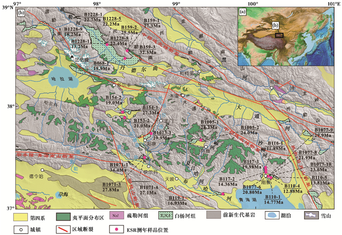
1 祁连山夷平面地貌特征夷平面是大陆长期剥蚀形成的跨流域的平坦地面,地面发育风化壳或其他碎屑堆积,它切过夷平前的所有岩体、地层和构造,夷平面地面坡度按现代准平原的基本形态一般小于2°,边缘地区可达3.5°~4°,因此,夷平面可以很好地记录区域构造地貌演化历史。祁连山夷平面是原始剥蚀平原经构造抬升与河流切割后残留下的保存在山地顶部的平缓地面,主要分布在南祁连,其南、北两侧分别被海拔5100~5400 m的宗务隆山与青海南山及海拔5500~6000 m的北西向疏勒南山、托勒南山和大通山所围限,夷平面自北西向南东逐渐降低。中祁连和北祁连山由于河流切割及晚新生代山脉的快速隆升,夷平面仅在中祁连局部保留。考虑祁连山地区夷平面经受构造抬升和解体,将夷平面坡度限定在地面坡度 < 2°,边缘地区 < 8°~9°。在野外调查的基础上,结合DEM分析勾绘出祁连山地区夷平面分布图(图 1)。

|
图 1 祁连山地区夷平面分布及白杨河组ESR年龄 Fig. 1 Distribution of the planation surface and the ESR ages of Baiyanghe Formation in Qilian Mountains |
夷平面在哈拉湖至青海湖一线长约300 km、南北宽约70 km的中祁连中段保存较好(图 1b),分布大片较连续顶部地形十分平坦的夷平面,地势起伏和缓,相对高度一般在300~600 m左右,地面坡度大多在15°以下,夷平面受到高原强烈隆起、掀斜与断陷作用及布哈河和沙柳河等河流溯源侵蚀影响,北西向展布的哈拉湖、青海湖、阳康曲上游及舟群乡等地小型断陷盆地将夷平面分割成空间上不连续的区域,以阳康-龙门隆起为界可分为东、西两个夷平面相对完整的区域。
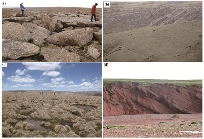
阳康以西夷平面主要分布在宗务隆山以北地区,志留纪中酸性侵入体和古生代-中生代地层被夷平(图 2a),除哈尔科一带北西走向的志留纪变质岩残留的山顶面高出夷平面500 m左右外(海拔高度4950~5050 m左右),夷平面海拔高度一般为4350~4600 m,地面坡度1°~2°,与现代夷平面形态特征类似。夏日格曲和巴音郭勒曲切割夷平面,下切深度500~700 m。哈拉湖盆地周缘夷平面海拔高度4100~4200 m,湖盆中的内流河下切较浅,多尔丰夷平面海拔高度4000~4200 m,并被阳康曲上游支流所切割,下切200 m左右。

|
图 2 祁连山地区夷平面地貌特征 (a)哈拉湖南花岗岩形成的石海及夷平面;(b)天峻北三叠系大加连组褶皱被夷平;(c)天峻北夷平面;(d)木里火烧沟组褶皱构造被夷平 Fig. 2 Planation surface landform in Qilian Mountains area. (a)Granitic planation surface and the rock-block field in the south of Hala Lake; (b)Fold of Triassic Dajialian Formation truncated by the planation surface in the north of Tianjun; (c)Planation surface in the north of Tianjun; (d)Fold of Huoshaogou Formation truncated by the planation surface in Muli area |
阳康以东夷平面总体较完整,志留纪中酸性侵入体和古生代-中生代地层、特别是三叠纪大加连组灰岩组成的宽缓褶皱被夷平(图 2b),受差异构造抬升作用影响,总体向东南方向倾斜,整个地面坡度1°~2°,除下切深度430~480 m的夏日哈河、峻河等布哈河支流及沙柳河等近南北向河流切割外,夷平面形态基本保存完整(图 2c)。夏日哈河上游夷平面海拔4250~4370 m,往南东至吉尔孟河上游夷平面海拔降为4180~4240 m,青海湖北岸海拔为3660~3780 m,中北部地面坡度 < 1°,南部地面坡度1°~2°,连片面积从大于500 km2至数十平方千米不等。
中祁连和北祁连山由于河流切割及晚新生代山脉的快速隆升,夷平面仅在木里盆地和苏里盆地零星分布,海拔高度在4500~4900 m之间。木里盆地古近系火烧沟组被夷平(图 2d),夷平面被大通河及其支流下切支解,河流下切深度230~470 m,残留夷平面海拔高度4060~4300 m,而疏勒河上游夷平面被疏勒河及其支流下切肢解,残留夷平面海拔高度4050~4230 m,与木里盆地及南祁连东部夷平面海拔高度接近。
2 祁连山古河流与断陷盆地形成与演化影响河流沉积与下切机制的主要因素为河流内部动力系统的变化与外部气候变化、构造运动与基准面变化等[31~35]。内陆构造隆升区的河流阶地受气候变化与构造抬升共同控制,构造隆升幅度控制河流下切的深度,气候控制阶地的沉积过程,并影响河流的下切[36~39]。祁连山位于青藏高原东北缘,为典型的内陆构造隆升区,疏勒河、大通河及汇入青海湖的布哈河、沙柳河、倒淌河和哈尔盖河等河流及其河流阶地的形成与祁连山快速抬升关系密切,提供了可刻画祁连山夷平作用与抬升过程的构造地貌标志。
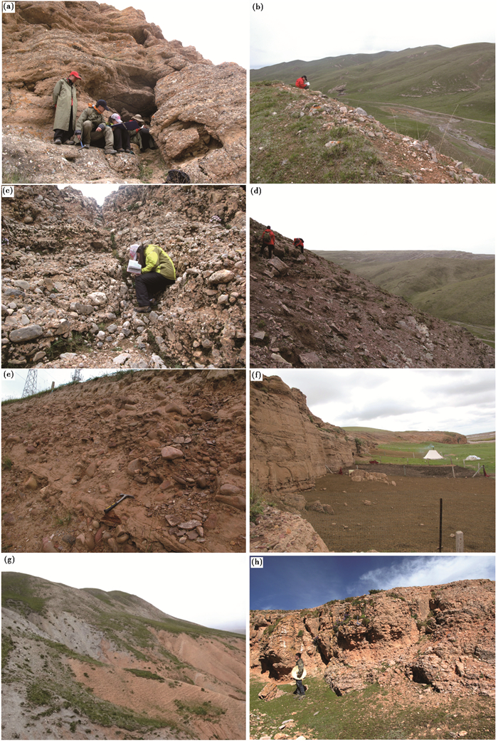
2.1 中-南祁连水系形成与演化源自疏勒南山和大通山的布哈河为注入青海湖的最大内流河,由布哈河及阳康曲、希格尔曲、夏日哈河、峻河、沙柳河等支流组成,阳康曲经阳康至快尔玛乡西与夏尔格曲汇合形成北西流向的布哈河,并向南东流经快尔玛、天峻县和吉尔孟乡后注入青海湖(图 1b)。中更新世之前布哈河为黄河支流,此时的布哈河通过青海湖“过境湖”入黄河,中更新世晚期由于日月山的急剧上升,隔断了布哈河入黄河的通道[40],使之成为青海湖的最大内流河。野外实际调查表明,沿布哈河及其支流古河道谷肩至河床沉积了渐新世-中新世白杨河组河流相砂砾岩;野外构造及古砾石层分布调查结果认为,阳康至龙门一带,由于中新世构造抬升及平行古河道的阳康逆冲断裂活动,布哈河上游河谷经历过一次改道,改道前的古河谷沿阳康-龙门一线呈北东东流向,沿古布哈河残留的冲积物分布在已废弃改道的古河谷中(图 3a);而在龙门东接近夷平面高度(4360 m)的希格尔曲东侧谷肩上分布有河流相砂砾岩,沿古河道河谷分布的砖红色砂砾岩海拔4000 m,河流在此段下切深度约360 m。在快尔玛北河流相砾石层(图 3b和3c)从海拔3724 m的谷底连续堆积到接近夷平面高度(海拔3924 m)的谷肩,河流在此段下切深度约200 m,支流夏日哈河从夷平面附近的高阶地砾岩也显示河流下切近200 m(图 3d)。青海湖北侧高出湖面150 m的砖红色砾岩和粗砂岩属于古沙柳河堆积的残留,砾石磨圆较好(图 3e),由于青海湖盆形成于上新世[41],此时的古沙柳河应属于布哈河支流,通过青海湖这一“过境湖”入黄河。厚达100余米的刚察河流相沉积物海拔为3350 m,与刚察县北部夷平面海拔(3390 m)接近。古布哈河不同地段最高堆积物海拔与所切夷平面海拔高度接近,表明河流在构造抬升并终止夷平作用过程后开始强烈下切,古沟谷河流广泛发育的起始时间代表了构造抬升和夷平作用结束的时间。

|
图 3 祁连山地区河流沉积物特征 (a)阳康北古布哈河低阶地砂砾岩;(b)快尔玛北古布哈河高阶地砂砾岩;(c)快尔玛北沿古布哈河低阶地砾岩;(d)夏日哈河高阶地砂砾岩;(e)刚察东河流相砂砾岩;(f)青海湖北岸河湖相砂岩和砂砾岩;(g)瓦乌斯南砖红色砂岩;(h)多尔丰南断陷盆地充填的砾岩 Fig. 3 Characteristics of the fluvial deposit in Qilian Mountains area. (a)Ancient Buha River lower terraces conglomerate in the north of Yangkang; (b)Ancient Buha River higher terraces conglomerate in the north of Kaierma; (c)Ancient Buha River lower terraces conglomerate in the north of Kuaierma; (d)Xiariha River higher terraces conglomerate; (e)Fluvial sandstone and conglomerate to the east of Gangcha; (f)Fluvial sandstone and conglomerate to the north of Qinghai Lake; (g)Brick red sandstone in the south of Wawusi; (h)The conglomerate in north of Duoerfeng Basin |
发育于中祁连的大通河和疏勒河其上游为由早期湖盆演化而来的宽谷,古沟谷河流与湖泊沉积物分布于现代河谷南北两侧山坡,由于托勒南山晚新生代向南逆冲(图 3g),新生代沉积岩与晚古生代地层断层接触。
2.2 南祁连断陷盆地群祁连山的隆升造成强烈的断裂和断块升降,形成哈拉湖、青海湖、多尔丰、舟群等新生代断陷盆地群。青海湖缺失白垩纪-古近纪地层,最老的地层为新近纪棕红-灰黄色碎屑岩,青海湖北岸刚察一带出露渐新世-中新世白杨河组[41~42]砂岩与砂砾岩(图 3f),可能为青海湖断陷盆地接受的最早沉积物,地球物理与钻孔揭示青海湖沉积物为厚度超过700 m泥质粉砂和粉砂质粘土等湖相沉积[43],微体古生物化石指示盆地基底上覆湖相细碎屑岩为新近纪沉积[44],意味着渐新世-新近纪时期布哈河和沙柳河流经青海湖而注入古黄河。哈拉湖晚新生代-第四纪沉积厚度达500 m左右,盆地断陷幅度达950~1000 m,该盆地向东延伸至多尔丰南由3个北西和北东向小盆地组成,向南东延伸至舟群乡形成北西向断陷盆地,盆地南北两侧均为三叠系大加连组灰岩褶皱被夷平形成的夷平面,盆地垂直断距约200 m,盆地边缘沉积砖红色白杨河组砂砾岩。从哈拉湖盆地周缘残留的白杨河组砖红色砂岩和多尔丰南盆地充填的灰岩砾石组成的砾岩(图 3h)及舟群盆地中白杨河组砖红色砂砾岩判断,北西向展布的哈拉湖盆地、多尔丰盆地、舟群盆地及青海湖盆地均形成于夷平面形成之后,盆地群的形成时代可以约束祁连山新生代构造隆升及夷平面形成时代。
3 祁连山夷平面形成时代夷平面形成时代的确定是夷平面研究的难点之一。目前主要有年界法、残留风化壳法和相关沉积法[45]。如前所述,祁连山构造与隆升作用导致古沟谷河流与断陷盆地广泛发育,形成的河湖相沉积可以用来限定夷平作用的终止时代及夷平面遭受破坏与高原隆升的时代。本研究采集了中祁连和北祁连切割夷平面的古沟谷河流与断陷盆地沉积物,进行电子自旋共振(ESR)测年,以确定夷平面的形成时代及祁连山隆升时代。
3.1 样品采集在中祁连和北祁连切割夷平面的古河流与断陷盆地内,选取代表性地点未被扰动的、含石英砂较好的粗砂细砾岩(层)中采集了ESR测年样品共29个(表 1)。采集过程中避免阳光直射,先去除剖面表层15~25 cm,使其出露新鲜面。由于大部分沉积物处于未胶结、半胶结状态,因此,使用直径6 cm、长25 cm,带尖刃钢管采集、密封。
| 表 1 祁连山白杨河组沉积物电子自旋共振(ESR)测年结果 Table 1 ESR dating results of the Baiyanghe Formation in Qilian Mountains |
ESR(Electron Spin Resonance,即电子自旋共振;或Electron Paramagnetic Resonance,简称EPR,称顺磁共振)是未成对电子自旋产生的磁矩所引起的共振吸收。ESR定年法自20世纪60年代问世以来就有相对独立的两支。一支即广泛用于第四纪沉积物及动物化石测年的人工附加剂量ESR定年法[46~53],测定对象包括石英、燧石、碳酸盐等矿物颗粒在沉积环境中普遍存在的U、Th、K等放射性元素的电离辐射作用下,会产生不同类型的顺磁中心,随着埋藏时间的积累,顺磁中心的数量会不断增加。石英颗粒中的顺磁中心在外加直流磁场的作用下,会产生能级分裂,当满足共振条件时,处在上下两能级的电子发生受激越迁,其结果是有一部分低能级的电子吸收电磁波能量越迁到高能级中,即产生电子顺磁共振现象(实验室测量的ESR信号)。实验模拟、理论推测和实际测量结果表明,如果采用适当的石英ESR信号中心和测量参数,ESR法可以测定含石英沉积物的最后一次曝光年龄,即可以测定最后一次埋藏事件以来的时间—埋藏年龄。由于受辐照饱和效应限制,测程为0~2 Ma。另一支是根据达尼列维奇等的“放射缺陷法”学术思想建立起来的,测程2200 Ma,该方法由梁兴中等[54~56]引入中国并进行研究和拓展,称之为:石英热活化ESR定年法(heat-activated ESR dating of a quartz,简称HAESRDQ)。已经被广泛应用于构造矿床、断层及火山年代、新生代沉积物等研究领域[57~63]。
石英硅-氧四面体在γ、β、α射线综合轰击下能在亿年内不断产生氧空位和顺磁中心,不会出现饱和现象[54~56]。氧空位捕获一个自由电子形成一个顺磁中心,根据泡里不相容原理,一个氧空位也可以捕获两个自旋态相反的电子,形成一个反磁中心。顺磁中心和反磁中心都储存了辐射能,因此α石英中的顺磁中心和反磁中心的总量就代表了吸收的总辐射能,也就是代表了总吸收剂量。必须把α石英颗粒中存在的反磁中心转变为顺磁中心之后,α石英中顺磁中心的总浓度才能代表所吸收的古剂量值,才能用来测定年龄。
石英的热活化技术就是实现反磁中心转变为顺磁中心的一种方法。实验证明:把α石英加热到300 ℃并在此温度中停留1200 s,则反磁中心中那个处于较高能态的电子获得了足够的热能恰能飞离,而反磁中心里那个处于较低能态的电子以及顺磁中心里那个处于低能态的电子,因为缺乏足够的能量不能逸出,仍限制在正2价的氧空位之中。所以热活化后的单位(g)质量α石英中顺磁中心浓度值就代表了总吸收剂量。
本研究取自沉积样品中的α石英经热活化处理后,测定其顺磁中心浓度值C,C包含以下几个来源:1)沉积成因部分:也就是从沉积开始直到取样为止(待求的年龄值t),由岩石中铀、钍、钾及宇宙射线在这段时间内所积累的顺磁中心;2)本底部分:也就是在沉积之前,在搬运过程中,α石英中在路途之中由于岩石中铀、钍、钾及宇宙射线得轰击所积累的顺磁中心。根据样品的铀、钍、钾及宇宙射线的年辐射剂量的比值,将钍、钾及宇宙射线的作用转换为(铀当量)可得到α石英结晶年龄T值。计算出宇宙射线和钾含量在T内产生的顺磁中心浓度值,并从C中扣除。根据本区样品统计,α石英在沉积前环境的放射性与沉积后岩石样品的放射性之比介于0.980~0.970,据此可以扣除顺磁中心浓度的本底部分。于是,只要测定了沉积样品的铀、钍、钾的含量,并用铀当量含量表示,就可得到沉积年龄。
3.2.2 测试过程、设备及环境(1) 样品测量条件:称取粒度0.2~0.3 mm的干燥石英120 mg,室温20~25 ℃,微波频率9.7652 GHz,微波功率0.21~0.30 mW,调制振幅0.25 Gpp,调制频率100kHz,放大系数7.11×10⁵~1.26×10⁶,时间常数50 ms,扫场范围3462.5~3550.0 G,在磁场强度3500.0~3512.5 G区间内可观测到α石英的自旋共振谱,其谱分裂因子g=2.0005±0.0005。
(2) 顺磁测定用ER-200D-SRC电子自旋共振谱仪,相对误差0.1 %。天然放射性核素含量用CIT-3000F数字化全自动铀钍钾谱谱仪测定,不确定度控制在10 %。剂量用丙氨酸剂量计标定,铀、钍、钾的年剂量根据其含量进行计算。宇宙射线剂量率与海拔有关,查文献获得。
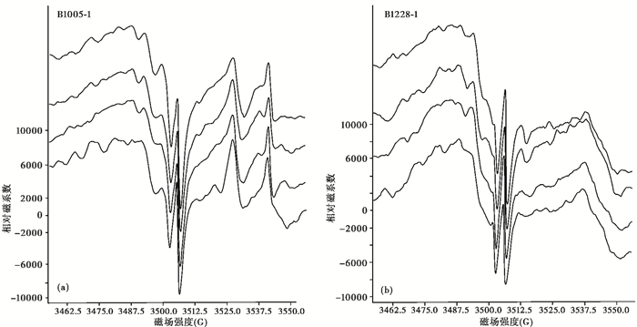
(3) 热活化后的α石英用电子自旋共振谱仪在相同的最佳测量条件下,分别测定待测样品和石英顺磁中心浓度标样的共振谱图(图 4)。为控制样品的测量精度,在样品测量前后各测定一次标样的自旋共振谱。每一页谱图中顶底两条谱线分别是顺磁浓度标样的谱图。样品顺磁中心浓度值通过与标样顺磁中心浓度值比较计算得到。标样顺磁中心浓度值为2.58×10¹⁵/g。

|
图 4 代表性样品电子自旋共振图谱 (a)样品B1005-1;(b)样品B1228-1 Fig. 4 Typical ESR resonance spectra of quartz extracted from of samples B1005-1 (a)and B1228-1 (b) |
一个方法的误差主要取决于可能产生误差的环节。石英热活化ESR定年法(HAESRDQ)的误差源有:1)ESR波谱振幅测量;2)Th/U比变化;3)封闭状态的U、Th衰变。它们对误差的贡献分别为≤ 1.7 %、≤4.1 %和≤2.5 %,最大叠和误差为约8.3 %,最终年龄误差为5.5 % ~10.0 %。
测试结果及相关参数见表 1。
由表 1和图 1可见,布哈河及其支流阳康曲、希格尔曲5个河流相砂岩的ESR年龄在34.4~16.93 Ma之间,沙柳河10个河流相砂岩的ESR年龄在29.9~11.89 Ma之间,多尔丰和舟群断陷盆地内沉积物中5个砂岩的ESR年龄在27.2~19.0 Ma之间,而中祁连山疏勒河上游丹德尔曲9个河湖相砂岩的ESR年龄在32.3~13.2 Ma之间。综合中-南祁连河流及盆地充填物形成时代可以看出,河流及盆地沉积集中发育于34.4~11.89 Ma期间,河流强烈下切始于渐新世早期,中新世中期由于构造作用导致河流改道与湖水外泻,从祁连山地区白杨河组与夷平面的关系分析,夷平面形成时代应在河流和盆地开始接受沉积之前。由此可以将祁连山夷平面形成时代限定在34 Ma之前,34 Ma左右祁连山夷平面开始解体并快速抬升。
4 结论与讨论青藏高原构造岩相古地理研究结果表明,祁连山在白垩纪晚期-始新世为隆起剥蚀区[64],构造活动较弱。祁连山中南部地区广泛分布的夷平面反映了长期稳定的构造环境,切割夷平面的河流和断陷盆地中沉积物ESR年龄(34.4~11.89 Ma)结果表明,祁连山构造抬升引起的河流下切与断陷作用始于渐新世早期,祁连山夷平面形成时代应在34 Ma之前。夷平面在祁连山周缘盆地中也有发现,高精度古地磁学与岩石磁学测年表明,河西走廊盆地中火烧沟组与上下地层不整合接触形成于40.2 Ma和33.4 Ma之前,前者揭示了青藏高原北部早期隆升,而后者指示了高原第二次强烈隆升以及以火烧沟组顶部为代表的晚始新世高原最早期夷平面的解体时间[65]。青藏高原东北部边缘的临夏盆地基底为30 Ma前解体的具厚层红色风化壳的夷平面[66]。综上所述,祁连山及邻区夷平面形成于始新世末,即34 Ma之前。
中祁连木里盆地不整合于白杨河组之下的火烧沟组(40.2~35.3 Ma)总体由细粒杂色粉砂质泥岩、粉砂岩和细砂岩组成[67],反映该盆地的周围山地在渐新世早期基本被夷平,火烧沟组顶部代表了祁连山晚始新世高原最早期夷平面。一般认为,发育红土风化壳及岩溶的夷平面取1000 m为其原始高度较为合理,临夏盆地基底具红色风化壳的夷平面原始高度应在1000 m左右,由祁连山地区早白垩世隆升作用[68]形成的厚达数百米的红色碎屑岩沉积推测,祁连山夷平面的原始高度也应在1000 m左右。
夷平面和剥蚀面停止发育是构造抬升终止侵蚀旋回的结果,因此夷平面的解体指示祁连山在34 Ma之前发生了强烈隆升,火烧沟组和白杨河组均为河湖相的沉积特征[67],说明构造隆升的幅度不大,祁连山古河流下切深度和断陷盆地垂直断距(200~400 m)可能代表了此次构造隆升的幅度。磷灰石裂变径迹模拟显示白垩纪中晚期-渐新世(115~25 Ma)祁连山构造平静,南祁连和疏勒南山冷却速率及剥蚀速率均较低[68],暗示始新世末祁连山以整体隆升为主,差异升降不明显。此次隆升事件记录的构造变形广泛存在于祁连山及青藏高原南部地区。河西走廊盆地(33.4 Ma)与中祁连木里盆地(约35.3~32.6 Ma)白杨河组与火烧沟组角度不整合接触记录的构造变形与隆升[65, 67],与生物地层学及热年代学揭示的柴北缘断裂和南山逆冲断裂带在40~33 Ma期间的活动[28]、可可西里地区在35~30 Ma期间发生的快速隆升作用[69]均为造成青藏高原夷平面解体的快速隆升的反映。
致谢: 感谢审稿专家建设性的修改意见以及编辑部老师悉心指导!
| [1] |
Tapponnier P, Xu Z Q, Roger F et al. Oblique stepwise rise and growth of the Tibet Plateau. Science, 2001, 294(23): 1671-1677. |
| [2] |
Yin A, Harrison T M. Geologic evolution of the Himalayan-Tibetan orogen. Annual Review of Earth Planet Science, 2000, 28(28): 211-280. |
| [3] |
李吉均, 方小敏. 青藏高原隆起与环境变化研究. 科学通报, 1998, 43(15): 1569-1574. Li Jijun, Fang Xiaomin. Research on the Tibetan Plateau uplifting and its environmental change. Chinese Science Bulletin, 1998, 43(15): 1569-1574. DOI:10.3321/j.issn:0023-074X.1998.15.001 |
| [4] |
An Z S, Kutzbach J E, Prell W L et al. Evolution of Asian monsoons and phased uplift of the Himalaya-Tibetan Plateau since Late Miocene times. Nature, 2001, 411(6833): 62-66. DOI:10.1038/35075035 |
| [5] |
Harrison T M, Copeland P, Kidd W S F et al. Raising Tibet. Science, 1992, 255(5052): 1663-1670. DOI:10.1126/science.255.5052.1663 |
| [6] |
Molnar P, England P, Martinod J. Mantle dynamics, uplift of the Tibet Plateau, and the Indian monsoon. Review of Geophysics, 1993, 31(4): 357-396. DOI:10.1029/93RG02030 |
| [7] |
李吉均, 文世宣, 张青松等. 青藏高原隆起的时代、幅度和形式的探讨. 中国科学(D辑), 1979(6): 608-616. Li Jijun, Wen Shixuan, Zhang Qingsong et al. Discussion on the time, amplitude and formalization of the Tibetan Plateau uplifting. Science in China(Series D), 1979(6): 608-616. |
| [8] |
Zhang H P, Craddock W H, Lease R O et al. Magnetostratigraphy of the Neogene Chaka basin and its implications for mountain building processes in the north-eastern Tibetan Plateau. Basin Research, 2012, 24(1): 31-50. DOI:10.1111/bre.2011.24.issue-1 |
| [9] |
Zhang H, Zhang P, Prush V et al. Tectonic geomorphology of the Qilian Shan in the northeastern Tibetan Plateau:Insights into the plateau formation processes. Tectonophysics, 2017, 706: 103-115. |
| [10] |
张大文, 张涛, 张伟林等. 柴西红沟子地区晚新生代沉积特征及其对阿尔金山隆升的约束. 第四纪研究, 2016, 36(4): 832-846. Zhang Dawen, Zhang Tao, Zhang Weilin et al. Late Cenozoic sedimentation characters of Honggouzi area in the western Qaidam Basin and its constraints on the uplift of the Altyn Tagh. Quaternary Sciences, 2016, 36(4): 832-846. |
| [11] |
李吉均, 方小敏, 潘保田等. 新生代晚期青藏高原强烈隆起及其对周边环境的影响. 第四纪研究, 2001, 21(5): 381-391. Li Jijun, Fang Xiaomin, Pan Baotian et al. Late Cenozoic intensive uplift of Qinghai-Xizang Plateau and its impacts on enviroments in surrounding area. Quaternary Sciences, 2001, 21(5): 381-391. |
| [12] |
Guo Z T, Ruddiman W F, Hao Q Z et al. Onset of Asian desertification by 22 Myr ago inferred from loess deposits in China. Nature, 2002, 416(6877): 159-163. DOI:10.1038/416159a |
| [13] |
Murphy M A, Yin A, Harrison T M et al. Did the Indo-Asian collision alone create the Tibetan Plateau?. Geology, 1997, 25(8): 719-722. DOI:10.1130/0091-7613(1997)025<0719:DTIACA>2.3.CO;2 |
| [14] |
Schneider W, Mattern F, Wang P J et al. Tectonic and sedimentary basin evolution of the eastern Bangong-Nujiang zone(Tibet):A reading cycle. International Journal of Earth Sciences, 2003, 92(2): 228-254. |
| [15] |
Kapp P, Yin A, Harrison T M et al. Cretaceous-Tertiary shortening, basin development, and volcanism in central Tibet. Geological Society of America Bulletin, 2005, 117(7-8): 865-878. |
| [16] |
Guynn J H, Kapp P, Pullen A et al. Tibetan basement rocks near Amdo reveal "missing" Mesozoic tectonism along the Bangong suture, central Tibet. Geology, 2006, 34(6): 505-508. DOI:10.1130/G22453.1 |
| [17] |
Otofuji Y, Mu Chuan-long, Tanaka K et al. Spatial gap between Lhasa and Qiangtang blocks inferred from Middle Jurassic to Cretaceous paleomagnetic data. Earth and Planetary Science Letters, 2007, 262(3): 581-593. |
| [18] |
Volkmer J E, Kapp P, Guynn J H et al. Cretaceous-Tertiary structural evolution of the north central Lhasa Terrane, Tibet. Tectonics, 2007, 26(6): TC6007. |
| [19] |
Yin A, Rumelhrt P E, Bulter R et al. Tectonic history of the Altyn Tagh fault system in northern Tibet inferred from Cenozoic sedimentation. Geological Society America Bulletin, 2002, 114(10): 1257-1295. DOI:10.1130/0016-7606(2002)114<1257:THOTAT>2.0.CO;2 |
| [20] |
Spicer R A, Harris N B W, Widdowson M et al. Constant elevation of southern Tibet over the past 15 million years. Nature, 2003, 421(6923): 622. DOI:10.1038/nature01356 |
| [21] |
Wang Chengshan, Zhao Xixi, Liu Zhifei et al. Constrains on the early uplift history of the Tibetan Plateau. Proceedings of the National Academy of Sciences of United States of America, 2008, 105(13): 4987-4992. DOI:10.1073/pnas.0703595105 |
| [22] |
Turner S, Hawkesworth C, Liu Jiaqi et al. Timing of Tibetan uplift constrained by analysis of volcanic rocks. Nature, 1993, 364: 50-54. DOI:10.1038/364050a0 |
| [23] |
An Zhisheng, Wang Sumin, Wu Xihao et al. Eolian evidence from Chinese Loess Plateau:The onset of Late Cenozoic great glaciation in Northern Hemisphere and Qinghai-Xizang Plateau uplift forcing. Science in China(Series D), 1999, 42(3): 258-271. DOI:10.1007/BF02878963 |
| [24] |
王瑜, 万景林, 李齐等. 阿尔金山北段阿克塞-党金山口一带新生代山体抬升和剥蚀的裂变径迹证据. 地质学报, 2002, 76(2): 191-198. Wang Yu, Wang Jinglin, Li Qi et al. Fission-track evidence for the Cenozoic uplift and erosion of the northern segment of the Altyn Tagh fault zone at the Aksay-Dangjin pass. Acta Geologica Sinica, 2002, 76(2): 191-198. |
| [25] |
Zheng Dewen, Zhang Peizhen, Wan Jinglin et al. Rapid exhumation at~8 Ma on the Liupan Shan thrust fault from apatite fission-track thermochronology:Implications for growth of the northeastern Tibetan Plateau margin. Earth and Planetary Science Letters, 2006, 248: 198-208. DOI:10.1016/j.epsl.2006.05.023 |
| [26] |
张培震, 郑德文, 尹功明等. 有关青藏高原东北缘晚新生代扩展与隆升的讨论. 第四纪研究, 2006, 26(1): 5-13. Zhang Peizhen, Zheng Dewen, Yin Gongming et al. Discussion on Late Cenozoic growth and rise of northeastern margin of the Tibetan Plateau. Quaternary Sciences, 2006, 26(1): 5-13. |
| [27] |
Meyer B, Tapponnier P, Bourjot L et al. Crustal thickening in Gansu-Qinghai, lithospheric mantle subduction, and oblique, strike-slip controlled growth of the Tibet Plateau. Geophysical Journal International, 1998, 135(1): 1-47. DOI:10.1046/j.1365-246X.1998.00567.x |
| [28] |
Yin A, Rumelhrt P E, Bulter R et al. Tectonic history of the Altyn Tagh fault system in northern Tibet inferred from Cenozoic sedimentation. Geological Society America Bulletin, 2002, 114(10): 1257-1295. DOI:10.1130/0016-7606(2002)114<1257:THOTAT>2.0.CO;2 |
| [29] |
崔之久, 高全洲, 刘耕年等. 夷平面、古岩溶与青藏高原隆升. 中国科学(D辑), 1996, 26(4): 378-386. Cui Zhijiu, Gao Quanzhou, Liu Gengnian et al. Planation, ancient karst and the Tibetan Plateau uplifting. Science in China(Series D), 1996, 26(4): 378-386. |
| [30] |
潘保田, 李吉均, 李炳元. 青藏高原地面抬升证据讨论. 兰州大学学报(自然科学版), 2000, 36(3): 100-111. Pan Baotian, Li Jijun, Li Bingyuan. Discussion on evidences for surface uplift of the Tibetan Plateau. Journal of Lanzhou University(Natural Sciences), 2000, 36(3): 100-111. |
| [31] |
Bridgland D R. River terrace systems in north-west Europe:An archive of environmental change, uplift and early human occupation. Quaternary Science Reviews, 2000, 19(13): 1293-1303. DOI:10.1016/S0277-3791(99)00095-5 |
| [32] |
Vandenberghe J. Climate forcing of fluvial system development:An evolution of ideas. Quaternary Science Reviews, 2003, 22(20): 2053-2060. DOI:10.1016/S0277-3791(03)00213-0 |
| [33] |
Bridgland D, Maddy D, Bates M. River terrace sequences:Templates for Quaternary geochronology and marine-terrestrial correlation. Journal of Quaternary Sciences, 2004, 19(2): 203-218. DOI:10.1002/(ISSN)1099-1417 |
| [34] |
Westaway R. Active crustal deformation beyond the SE margin of the Tibetan Plateau:Constraints from the evolution of fluvial systems. Global and Planetary Change, 2009, 68(4): 395-417. DOI:10.1016/j.gloplacha.2009.03.008 |
| [35] |
Maddy D, Bridgland D, Westaway R. Uplift-driven valley incision and climate controlled river terrace development in the Thames Valley, UK. Quaternary International, 2001, 79(1): 23-36. DOI:10.1016/S1040-6182(00)00120-8 |
| [36] |
Jia L, Zhang X, He Z et al. Late Quaternary climatic and tectonic mechanisms driving river terrace development in an area of mountain uplift:A case study in the Langshan area, Inner Mongolia, Northern China. Geomorphology, 2015, 234: 109-121. DOI:10.1016/j.geomorph.2014.12.043 |
| [37] |
Jia L, Zhang X, Ye P et al. Development of the alluvial and lacustrine terraces on the northern margin of the Hetao Basin, Inner Mongolia, China:Implications for the evolution of the Yellow River in the Hetao area since the Late Pleistocene. Geomorphology, 2016, 263: 87-98. DOI:10.1016/j.geomorph.2016.03.034 |
| [38] |
Jia L, Hu D, Wu H, Zhao X et al. Yellow River terrace sequences of the Gonghe-Guide section in the northeastern Qinghai-Tibet:Implications for plateau uplift. Geomorphology, 2017, 295: 323-336. DOI:10.1016/j.geomorph.2017.06.007 |
| [39] |
He Zexin, Zhang Xujiao, Qiao Yansong et al. Formation of the Yalong downstream terraces in the SE Tibetan Plateau and its implication for the uplift of the Plateau. Acta Geologica Sinica(English Edition), 2015, 89(2): 542-560. DOI:10.1111/1755-6724.12446 |
| [40] |
杨惠秋, 江德昕. 青海湖盆地第四纪孢粉组合及其意义. 地理学报, 1965, 31(4): 321-344. Yang Huiqiu, Jang Dexin. Quaternary palynological assemblage and its significance in Qinghai Lake Basin. Acta Geographica Sinica, 1965, 31(4): 321-344. |
| [41] |
袁宝印, 陈克造, Bowler J M等. 青海湖的形成与演化趋势. 第四纪研究, 1990(3): 233-243. Yuan Baoyin, Chen Kezao, Bowler J M et al. The formation and evolution of the Qinghai Lake. Quaternary Sciences, 1990(3): 233-243. |
| [42] |
孙健初. 祁连山一带地质史纲要. 地质论评, 1942, 7(Z1): 17-26. Sun Jianchu. Geological history of Qilian Mountain. Geological Review, 1942, 7(Z1): 17-26. |
| [43] |
安芷生, 王平, 沈吉等. 青海湖湖底构造及沉积物分布的地球物理勘探研究. 中国科学(D辑), 2006, 49(4): 332-341. An Zhisheng, Wang Ping, Shen Ji et al. Geophysical survey on the tectonic and sediment distribution of Qinghai Lake basin. Science in China(Series D), 2006, 49(8): 851-861. |
| [44] |
Li J J, Wen S X, Zhang Q S et al. A discussion on the Qinghai-Xizang Plateau. Scientia Sinica, 1979, 22(12): 1314-1328. |
| [45] |
潘保田, 高红山, 李吉均. 关于夷平面的科学问题——兼论青藏高原夷平面. 地理科学, 2002, 22(5): 520-526. Pan Baotian, Gao Hongshan, Li Jijun. On problems of planation surface-A discussion on the planation surface in Qinghai-Xizang Plateau. Scientia Geographica Sinica, 2002, 22(5): 520-526. |
| [46] |
刘春茹, 尹功明, 高璐等. 泥河湾盆地东坡遗址ESR年代学初步研究. 第四纪研究, 2009, 29(1): 166-172. Liu Chunru, Yin Gongming, Gao Lu et al. ESR dating of Dongpo Paleolithic site in the Nihewan Basin of China. Quaternary Sciences, 2009, 29(1): 166-172. |
| [47] |
刘春茹, 尹功明, 高璐等. 第四纪沉积物ESR年代学研究进展. 地震地质, 2011, 33(2): 490-498. Liu Chunru, Yin Gongming, Gao Lu et al. Research advances in ESR geochronology of Quaternary deposits. Seismology & Geology, 2011, 33(2): 490-498. |
| [48] |
尹功明, 林敏. 沉积物电子自旋共振测年现状. 核技术, 2005, 28(5): 399-402. Yin Gongming, Lin Min. Present status of ESR dating of sediments. Nuclear Techniques, 2005, 28(5): 399-402. |
| [49] |
刘春茹, 尹功明, 韩非等. 石英ESR测年法在第四纪陆相沉积物测年中的应用. 第四纪研究, 2016, 36(5): 1236-1245. Liu Chunru, Yin Gongming, Han Fei et al. ESR dating methodology and its application in dating Quaternary terrestrial sediments. Quaternary Sciences, 2016, 36(5): 1236-1245. |
| [50] |
韩非, 尹功明, 刘春茹等. 电子自旋共振(ESR)化石测年及其在晚新生代动物群年代学研究中的应用. 第四纪研究, 2015, 35(3): 776-783. Han Fei, Yin Gongming, Liu Chunru et al. The potential of direct dating Late Cenozoic fossils by combined ESR/U-series method. Quaternary Sciences, 2015, 35(3): 776-783. |
| [51] |
邵庆丰, 韩非, Jean-Jacques Bahain. 华南早更新世巨猿动物群的ESR/U-系年代. 第四纪研究, 2016, 36(5): 1224-1235. Shao Qingfeng, Han Fei, Jean-Jacques Bahain. Coupled ESR/U-series age estimates for Early Pleistocene Gigantopithecus faunas in Southern China. Quaternary Sciences, 2016, 36(5): 1224-1235. |
| [52] |
张威, 刘亮, 柴乐等. 基于年代学证据的螺髻山第四纪冰川作用研究. 第四纪研究, 2017, 37(2): 281-292. Zhang Wei, Liu Liang, Chai Le et al. Characteristics of Quaternary glaciations using ESR dating method in the Luoji Mountain, Sichuan Province. Quaternary Sciences, 2017, 37(2): 281-292. |
| [53] |
姜大伟, 张世民, 丁锐等. 龙门山南段前陆区古冲积扇分析及河流地貌面序列的建立——基于地貌面的测年数据、野外地貌分析与调查. 第四纪研究, 2016, 36(5): 1263-1279. Jiang Dawei, Zhang Shimin, Ding Rui et al. A fluvial morphologic surface sequence based on the research of alluvial fans in the forland region of southern Longmen Shan-According to the dating methods, field survey, and geomorphological analysis. Quaternary Sciences, 2016, 36(5): 1263-1279. |
| [54] |
梁兴中. 电子自旋共振测年方法原理及其在地质学中的应用. 国土资源科技管理, 1991(1): 55-58. Liang Xingzhong. Electron spin resonance dating method principle and its application in geology. Scientific and Technological Management of Land and Resources, 1991(1): 55-58. |
| [55] |
梁兴中, 陈继镛, 冯家岷. α石英E'心断代零点研究. 核技术, 1993, 16(4): 213-216. Liang Xingzhong, Chen Jiyong, Feng Jiamin. A study on resetting for E' centre dating of α-quartz. Nuclear Techniques, 1993, 16(4): 213-216. |
| [56] |
梁兴中, 高钧成. 断裂成矿年龄的α石英ESR研究. 矿物岩石, 1999(2): 69-71. Liang Xingzhong, Gao Juncheng. Study on the α-quartz dating of fault-related ore mineralization. Journal of Mineralogy and Petrology, 1999(2): 69-71. |
| [57] |
钟康惠, 梁兴中, 刘肇昌等. 藏东三江构造带云南段α石英热活化ESR定年与新生代构造事件. 地质通报, 2004, 23(12): 1231-1237. Zhong Kanghui, Liang Xingzhong, Liu Zhaochang et al. Heat-activated ESR dating of α quartz and Cenozoic tectonic events in the Yunnan segment of the Sanjiang tectonic zone, eastern Tibet. Geological Bulletin of China, 2004, 23(12): 1231-1237. DOI:10.3969/j.issn.1671-2552.2004.12.011 |
| [58] |
杨坤光, 梁兴中, 谢建磊等. ESR定年:一种确定脆性断层活动年龄的方法原理与应用. 地球科学进展, 2006, 21(4): 430-435. Yang Kunguang, Liang Xingzhong, Xie Jianlei et al. ESR dating, the principle and application of a method to determine active ages of brittle faults. Advances in Earth Science, 2006, 21(4): 430-435. |
| [59] |
沈传波, 梅廉夫, 汤济广等. 大巴山逆冲推覆带构造扩展变形的年代学制约. 原子能科学技术, 2008, 42(6): 574-576. Shen Chuanbo, Mei Lianfu, Tang Jiguang et al. Geochronology evidences for tectonic deformation of Dabashan fold-thrust belt in Central China. Atomic Energy Science & Technology, 2008, 42(6): 574-576. |
| [60] |
朱清波, 杨坤光, 程万强. 江南隆起带北缘新生代构造演化的石英ESR年代学研究. 现代地质, 2011, 25(1): 31-38. Zhu Qingbo, Yang Kunguang, Cheng Wanqiang. Structural evolution of northern Jiangnan uplift:Evidence from ESR dating. Geoscience, 2011, 25(1): 31-38. |
| [61] |
Ren S, Song C, Li J. Application of electron spin resonance(ESR) dating to ductile shearing:Examples from the Qinling orogenic belt, China. Journal of Structural Geology, 2016, 85: 12-17. DOI:10.1016/j.jsg.2016.02.002 |
| [62] |
Jia L, Hu D, Wu H et al. Yellow River terrace sequences of the Gonghe-Guide section in the northeastern Qinghai-Tibet:Implications for plateau uplift. Geomorphology, 2017, 295: 323-336. DOI:10.1016/j.geomorph.2017.06.007 |
| [63] |
陶涛, 王超群, 戚帮申等. 青海湖鸟岛北原生砂楔的发现及其古气候意义. 第四纪研究, 2016, 36(5): 1246-1252. Tao Tao, Wang Chaoqun, Qi Bangshen et al. Fossil sand wedges of north Niaodao in Qinghai Lake:Discovery and paleoclimatic implications. Quaternary Sciences, 2016, 36(5): 1246-1252. |
| [64] |
张克信, 王国灿, 季军良等. 青藏高原古近纪-新近纪地层分区与序列及其对隆升的响应. 中国科学:地球科学, 2010, 40(12): 1632-1654. Zhang Kexin, Wang Guocan, Ji Junliang et al. Paleogene-Neogene stratigraphic realm and sedimentary sequence of the Qinghai-Tibet Plateau and their response to uplift of the plateau. Science China:Earth Sciences, 2010, 40(12): 1632-1654. |
| [65] |
戴霜, 方小敏, 宋春晖等. 青藏高原北部的早期隆升. 科学通报, 2005, 50(7): 673-683. Dai Shuang, Fang Xiaomin, Song Chunhui et al. Northern Qinghai-Tibet Plateau early uplift. China Science Bulletin, 2005, 50(7): 673-683. |
| [66] |
Fang X M, Garzione C, Van der Voo Rob et al. Flexural subsidence by 29 Ma on the NE edge of Tibet from the magnetostratigraphy of Linxia Basin, China. Earth and Planet Science Letters, 2003, 210(3-4): 82-94. |
| [67] |
戚帮申, 胡道功, 王进寿等. 中祁连木里盆地古近系ESR年龄及地质意义. 地质力学学报, 2013, 19(4): 392-402. Qi Bangshen, Hu Daogong, Wang Jinshou et al. ESR dating of the palaeogene in Muli basin in the middle of Qilian Mountains and its geological significance. Journal of Geomechanics, 2013, 19(4): 392-402. |
| [68] |
戚帮申, 胡道功, 杨肖肖等. 祁连山中段白垩纪以来阶段性构造抬升过程的裂变径迹证据. 地球学报, 2016, 37(1): 46-58. Qi Bangshen, Hu Daogong, Yang Xiaoxiao et al. Apatite fission track study of the Cretaceous-Cenozoic stepwise uplift of the middle segment of the Qilian Mountain. Acta Geoscientica Sinica, 2016, 37(1): 46-58. DOI:10.3975/cagsb.2016.01.05 |
| [69] |
Liu Z F, Wang C S, Yi H S. Evolution and mass accumulation of the Cenozoic Hoh Xil basin, northern Tibet. Journal of Sedimentary Research, 2001, 71(6): 971-984. DOI:10.1306/030901710971 |
2 Key Laboratory of Neotectonic and Geohazard, Ministry of Natural Resources, Beijing 100081;
3 Cores and Samples Center of Land and Resources, China Geological Survey, Yanjiao 065201, Hebei;
4 Institute of Geology and Geophysics, Chinese Academy of Sciences, Beijing 100029)
Abstract
Formation age of the planation surface within the Qinghai-Tibet Plateau is a key to understand the uplifting time and amplitude of the plateau. There are planation surfaces, in elevation of 4100~4300 m, covering large areas of the Qilian Mountains region on the northeast margin of the Tibetan Plateau. Geological and geomorphological survey results show that the Palaeozoic granitoid intrusion and the Late Paleozoic-Paleozoic strata have been truncated by the planation surface, with the Eogene Huoshaogou Formation being preserved as the underlain youngest strata. The uplifting of Qilian Mountains triggered the formation of some deep incised valleys and fault basins and in this context, the formation of the overlain sediments from Oligo-Miocene Baiyanghe Formation may represent an planation termination and initiation of tectonic uplift in Qilian Mountains area. Overall 29 electron spin resonance(ESR) dating data shows that the Baiyanghe Formation was formed during 34.4 Ma and 11.89 Ma. Hence, we speculate that the planation surface in Qilian Mountains was likely formed at the end of Eocene(i.e., before 34 Ma), the contemporaneous altitude was about 1000 m, and the plantation surface probably began to disintegrate and Qinlian Mountains uplifted rapidly around 34 Ma. 2018, Vol.38

