2 兰州大学资源环境学院, 西部环境教育部重点实验室, 甘肃 兰州 730000;
3 中国科学院青藏高原地球科学卓越创新中心, 北京 100101)
柴达木盆地是亚洲沙尘的主要源地[1~4],同时又是黄土高原第四纪冰期、亚冰期风尘的主要来源区[2~5]。由于其地处东亚季风、西风带和印度季风交汇处,深受这3种风力系统的共同影响,对气候变化反应极为敏感[6~8]。为此,柴达木盆地风沙活动历史、风沙沉积与环境演化等方面的研究已得到较多重视。
柴达木盆地内终年多风,其内部大量沙物质随风运移,在盆地边缘由于山地等地貌单元阻挡发生堆积形成诸多风积地貌类型,如古沙丘、灌丛沙丘等。较多的研究者多是根据盆地内的盛行风向进行推测,盆地边缘的风沙地貌物质主要来源于干旱时期的湖底沉积物,认为其经风化剥蚀、搬运,而后在盆地边缘堆积,从而发育了大量的风沙地貌类型[6~9],但缺少必要的物源证据。
盆地内三湖地区、盆地西南部及东南部等边缘地区风积地貌的广泛发育,很好地记录了区域气候系统变化及风沙活动历史[10]。因此,灌丛沙丘作为区域气候环境控制下的地貌类型,其沉积演化必然与区域风沙过程、气候环境之间有着密切的联系。截至目前,对柴达木盆地盐湖周边灌丛沙丘的研究还非常少,且局限于植被、沙丘形态方面的研究[11~12]。有关这些灌丛沙丘的发育年代、物质来源及其对气候环境、风沙活动的响应过程尚不清楚。
为此,鉴于稀土元素(Rare Earth Element,简称REE)对物源的指示意义[13~18],我们对柴达木盆地盐湖周边灌丛沙丘风沙沉积物用REEs特征进行物源判别,并采用光释光(Optically Stimulated Luminescence,简称OSL)及加速14C (Accelerator Mass Spectrometry 14C,简称AMS 14C)的测年手段对它们的发育年代进行研究,探讨了灌丛沙丘发育过程及其对干旱环境的响应关系。该研究工作的开展,对了解研究区风沙活动历史、古气候环境变化方面有着重要意义,同时,还可以进一步丰富和完善我国高寒、极旱的高原内陆盆地风沙地貌学的研究。
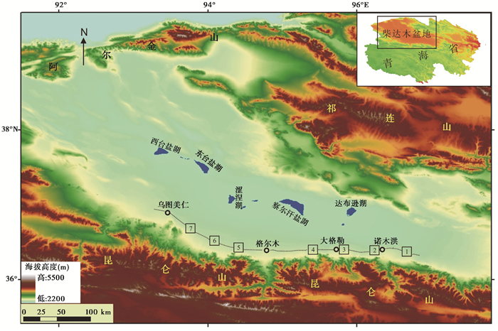
1 研究区与研究方法 1.1 研究区概况柴达木盆地是青藏高原北缘的一个构造断陷盆地,东西长约800 km,南北宽约300 km,面积约2.56×10⁵ km2,平均海拔2600~3000 m,四面分别为阿尔金山、祁连山及昆仑山环绕,其地貌呈同心环带状分布(图 1)。从盆地边缘至中心分布有高山、洪积扇、洪积倾斜平原、风沙地貌、湖积平原、风蚀残丘、盐湖等地貌类型,其中风沙地貌类型主要分布于西南缘大沙带、三湖区小沙带和东南缘沙区,此外,盆地北部也有零星沙地,其荒漠特征较为显著[9]。柴达木盆地属干旱、多风、寒冷的大陆性气候特征,多年平均气温为3.5 ℃左右,1月气温最低,多在- 15~- 10 ℃之间,平均约- 12 ℃[19]。降水自东南向西北递减,如东南部年降水量200~300 mm,中部年降水量40~50 mm,西北部年降水量不足20 mm;多年平均日照时数达到3000 h以上;东部、东南部年蒸发量2000 mm以上,中心部分超过3600 mm,西部在3000 mm以上;盆地内风力强劲,年平均风速3.7 m/s以上[9]。柴达木盆地荒漠植被占植被总面积的63%,以具有高抗旱能力的灌木、半灌木和草本为主[11]。上述外部环境为灌丛沙丘的形成发育提供了有利条件。
|
图 1 柴达木盆地及采样区(黑色虚线部分为灌丛沙丘集中分布带) Fig. 1 Images of Qaidam Basin and sampling areas(nebkhas distribute along the black lines) |
选取自柴达木盆地东南的诺木洪农场以东约30 km处至西南部的乌图美仁乡附近(沿昆仑山北麓的洪积扇、绿洲、湖滨湿地等灌丛沙丘广泛分布带)为研究区,其大致介于36°15′~36°55′N,93°20′~96°50′E的范围内;该研究区为东西横跨约360 km,南北分布极窄的条带状区域(图 1)。区内灌丛沙丘多为柽柳(Tamarix chinensis Lour)、白刺(Nitraria tangutorum Bobr)、梭梭(Haloxylon ammodendron(C.A.Mey))等荒漠植被类型,沙丘发育规模存在较大差异,其高度自数米至数十米。总体而言,不同植被类型且处于不同发育阶段的灌丛沙丘广泛发育,从地貌单元上来看,其主要发育在山前冲积扇中下部至扇缘部位,向盆地中心依次为湖滨湿地草原、盐碱滩、盐湖(或干盐湖)等景观类型。
1.2 样品采集与实验测试 1.2.1 样品采集为了解柴达木盆地盐湖周边灌丛沙丘发育形成的年龄,在灌丛沙丘典型发育区域(如诺木洪、大格勒农场周边区域、乌图美仁东部山前冲积扇等地)选择了21个不同发育阶段和规模的灌丛沙丘,共采集OSL样品38个、AMS 14C样品5个(表 1和表 2),进行了灌丛沙丘的年代学研究,共涉及采样区7个(见图 1),由于每个采样区都控制50×50 m或100×100 m的范围内,面积较小,样区大致位置仅以单点坐标表示(详见表 1)。
| 表 1 样品剂量率与OSL年代 Table 1 U, Th and K concentration, OSL ages and depth of the samples collected from nebkhas |
| 表 2 样品13 C丰度与AMS 14C年代 Table 2 δ 13C nature abundance and AMS 14C ages of the samples |
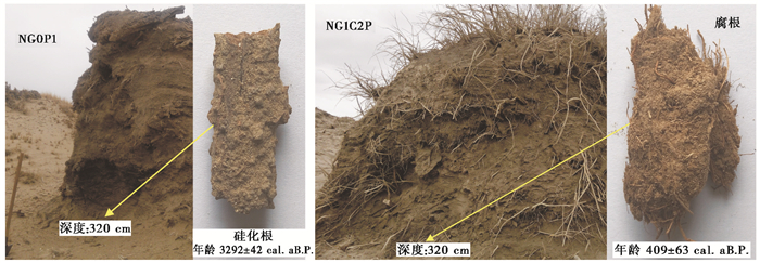
在OSL年代样品采集前,首先对现有露头开挖露出新鲜剖面,清除表面散落或风化沉积物,然后将脱籽棉花塞入不锈钢钢管(长约25 cm,直径约4 cm)一端,使该端沿风沙纹理水平打入沙丘沉积层。取出释光管,沉积物出露的另一端用棉花堵上,然后用胶带快速进行避光密封,并放入黑色塑料袋内避光。另外,在采OSL样品的位置同时采一袋全样以备实验室内测定样品的年剂量率及含水量,也可作为其他环境代用指标测样用。为进行年代的相互校验,根据实际情况选取植物腐朽根系、硅化根、炭屑等(图 2)作为AMS 14C年龄测试的样品。此外,分别在图 1中1、2、5、7这4个不同区域的7个剖面(NG0P2、NG1P1、NG1CP、NG1C2P、HGP、WGP1和WGP2)中采取了77个风沙沉积物样品用于REEs含量分析。但由于其中的3个剖面的稀土测试样本量较少,且稀土的含量值均在其他4个剖面的变化范围之内,因此本文主要介绍4个剖面(NG0P2、NG1P1、HGP和WGP1)的REEs含量研究结果。
|
图 2 灌丛沙丘中柽柳硅化、腐烂根系及AMS 14C年龄 Fig. 2 Silicified and rotten roots of Tamarix from nebkhas and their AMS 14C ages |
OSL年代分别在中国科学院青海盐湖研究所、福建师范大学湿润亚热带山地生态国家重点实验室(培育基地)光释光实验室测试完成。所有样品的前处理参照相关文献所述方法和实验测试要求在暗室中进行[20~21],提取的石英样品采用丹麦科技大学生产的Risø TL/OSL-DA-20型全自动释光仪测试。De的测定利用单片再生剂量法(Single Aliquot Regeneration,简称SAR)[22]测定,该方法在柴达木盆地风沙沉积物年代测定中已得到了很好验证[6~8]。样品剂量率等参数详见表 1。
1.2.3 AMS 14C样品测年AMS 14C年代在中国科学院地球环境研究所西安加速器质谱中心测试完成。原始样品经过物理分选、化学预处理、充分燃烧等3个步骤,从而将原始样品中的含碳化合物提取并转化成CO2,最终还原成石墨单质[23~24],用于AMS 14C年代测定。
1.2.4 风沙沉积物REEs测定REEs采用微波消解、加硝酸提取,然后在美国热电公司生产的X-SERIES型ICP-MS质谱仪上测试,同时用黄土标准物质进行质量控制[15],整个实验过程在福建师范大学湿润亚热带山地生态国家重点实验室(培育基地)完成。
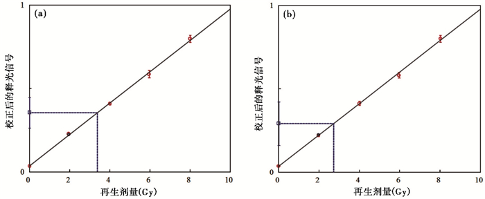
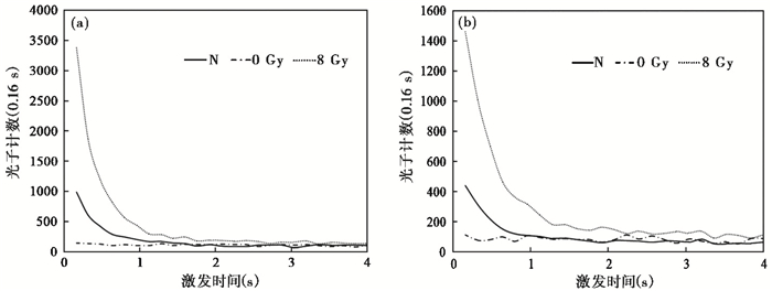
2 结果分析 2.1 灌丛沙丘年代柴达木盆地盐湖周边灌丛沙丘沉积物OSL测年信号等参数特征总体相似。其中,部分样品校正后的OSL等效剂量生长曲线和OSL信号衰减曲线见图 3和图 4。热转移信号的检测通过零剂量信号(L0/Tx)与自然信号(Lx/Tx)的比值来检测,结果显示信号比值稳定,在3%左右;衰减曲线变化趋势相似,表明其OSL信号的贡献都是主要来自于快速衰减组分。由于灌丛沙丘年龄比较轻,其自然信号较低,导致零剂量信号与自然信号的比值稍高,但都小于8%,对测年结果影响不大。采用“循环比”对被检测样品的释光感量变化进行校正[22],所有样品的“循环比”都介于0.9~1.1之间,属于比较理想的范围。
|
图 3 样品NG1C2P-0(a)和WG3P-2(b)增长曲线 Fig. 3 Growth curves of samples NG1C2P-0(a) and WG3P-2(b) |
|
图 4 样品NG1C2P-0(a)和WG3P-2(b)衰减曲线 Fig. 4 Decay curves of samples NG1C2P-0(a) and WG3P-2(b) |
研究区灌丛沙丘发育的OSL及AMS 14C年代详细数据见表 1和表 2。年代测试结果表明它们主要发育于全新世以来,且多发育于中、晚全新世以后。仅个别沙丘年代较久,如WDGP3的OSL年龄为15.5 ka B.P.,属于末次冰盛期以后和全新世以前;NG1CP-14C的AMS 14C年龄为11799±158 cal.a B.P.,属于全新世最初期;其余沙丘年代多为中晚全新世时期以来,如WG3P-14C和NG0P2-14C的AMS 14C年龄分别为6260±33 cal.a B.P.和5537±44 cal.a B.P.,WDGP4的OSL年龄为4.7±1.0 ka B.P.,属于中晚全新世;其余多在距今3000年以内。从测年结果看,除个别灌丛沙丘外,其余各灌丛沙丘沉积物样品的年代与下老上新的地层顺序符合(见表 1深度与年龄关系),其发育年龄较为可信。据有关研究显示,本文研究的灌丛沙丘所分布区域皆为全新世地层[25],灌丛沙丘发育年龄与其所在大区沉积地层的地质背景吻合。
从灌丛沙丘两种不同年代测试方法获得的数据结果来看(表 1和表 2),所获得的年龄都分布于一个较大的时间尺度内,但剖面同一深度的OSL与AMS 14C年龄存在一定差异。结合采样实际过程、剖面及样品野外属性等方面的信息,认为其差异性可能与样品的野外选取有关。样品野外采集过程中,我们很难准确判定同一地层深度的OSL与AMS 14C样品的时代统一性;而灌丛沙丘(NG1CP)中采集的黑灰色较老炭屑还存在随风沙外源输入的可能性。此外,这可能主要与灌丛沙丘的发育过程有关。因为,灌丛沙丘的沉积过程存在不连续性,尤其是年代久远的灌丛沙丘更是如此。当灌丛(柽柳或白刺)生长时沙丘沉积增长;当灌丛死亡后,沙丘可能会活化并因侵蚀而削低,沉积增长过程中断,直到有新的植株在其上重新生长,再一次阻沙或接受沉积,灌丛沙丘再一次增长[26]。OSL年代结果(表 1)显示,柴达木盆地灌丛沙丘沉积可能上千年甚至上万年,但一种灌丛植株的生命周期不可能有几千年更不可能上万年,因此,较老灌丛沙丘上的灌丛必定存在“死亡-再生长”的交替过程。另外,新植株在沙丘上生存后,根系等会扎入老灌丛沙丘内部,死亡腐烂后所提供的测年碳物质只能代表植株年龄,并不能准确反映沙丘的沉积年龄。鉴于此,AMS 14C方法可能并不太适合用于灌丛沙丘定年。
2.2 灌丛沙丘OSL年龄与深度柴达木盆地盐湖周边灌丛沙丘广泛发育,其高度从数米到十多米,个体规模差异较大。为进一步了解这些灌丛沙丘发育规模(高度)与年龄的关系,将所有沙丘高度(剖面深度)-OSL年龄进行对应关系分析(图 5)。结果显示,深度-OSL年龄散点图其各点相对比较分散,并不存在明显的相关关系。究其原因可能有以下两方面:一方面由于灌丛沙丘可能存在“固定增长—衰退活化—再固定”的不连续沉积发育过程;同时所研究的各个灌丛沙丘所处的发育阶段不同,比如,处于衰退阶段的灌丛沙丘顶部因受风蚀而不能很好表征其真实高度。另一方面由于灌丛沙丘分布于不同采集区,受物源供给、植被盖度等多因素影响,其沉积速率也存在较大差异。总之,柴达木盆地灌丛沙丘发育过程中受多种外部因素影响,且有较多的后期外力改造作用存在,其沉积过程复杂,未表现出统一的年龄-高度(深度)模式。
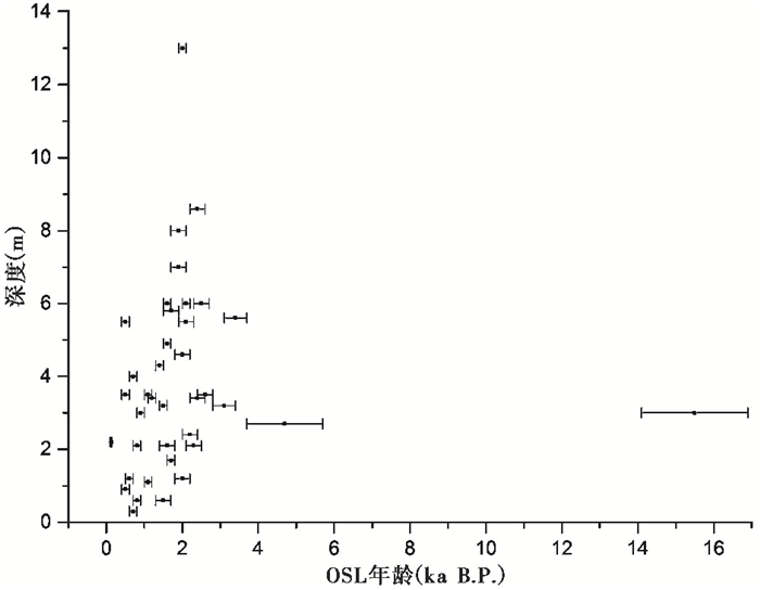
|
图 5 灌丛沙丘深度与OSL年龄散点图 Fig. 5 Scatter plot of the depth-OSL age of nebkhas |
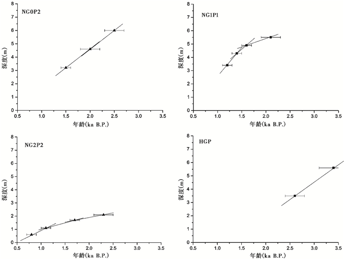
此外,在具有两个及以上OSL年代的8个剖面中,选取NG0P2、NG1P1、NG2P2和HGP这4个剖面进行年龄-深度模式分析(图 6),并与图 5对比。结果表明,所选取的4个灌丛沙丘年龄与深度存在明显的线性关系,但模式存在较大差异。灌丛沙丘NG0P2深度-年龄为直线模式,且斜率较大;NG1P1底部斜率较小,上部斜率逐渐变大;NG2P2线图的斜率总体较小;而HGP的斜率与NG0P2相近,但其反向延长线并未交于坐标轴零点附近,表明该沙丘顶部应该受到了一定程度的侵蚀。总体而言,上述深度-年龄模式图线斜率大小可以直接反映随深度变化其年龄变率;斜率愈大,深度发生一定变量其年龄变化较小;相反则年龄变化较大。此外,其还可以一定程度反映灌丛沙丘大致的沉积速率。
|
图 6 灌丛沙丘深度-OSL年龄模式 Fig. 6 Depth-OSL age models of nebkhas |
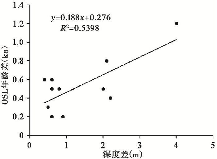
最后,将具有两个及以上OSL年龄的8个灌丛沙丘剖面进行年龄变量-深度变量的回归分析(图 7),结果表明:年龄变量与深度变量之间存在Y=0.188X+0.276的方程式,其相关系数R2=0.539,置信水平为0.99%,呈极显著相关。因此,刨去灌丛沙丘顶部部分,柴达木盆地盐湖周边灌丛沙丘年龄和深度存在显著的正相关性;可以通过上述回归方程得出深度变量与年龄变量的对应关系或沉积速率与年龄的关系。
|
图 7 OSL年龄差与深度差相关性 Fig. 7 Correlation between OSL age difference and height difference |
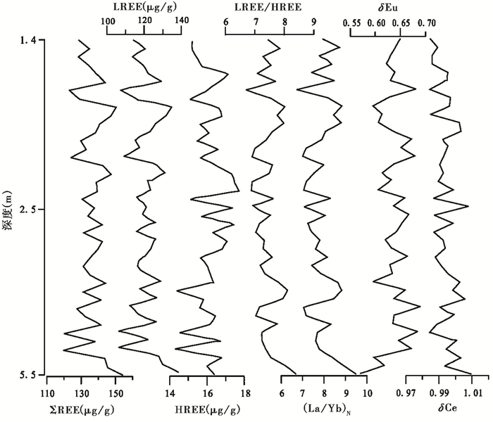
为判定灌丛沙丘物质来源对其风沙沉积物进行了REEs测试,其REEs含量及变化特征总体相似,本文仅以采样区2中的NG1P1柽柳灌丛沙丘剖面为例分析其特征。该沙丘风沙沉积物各REE参数随深度的波动明显,且各指标变化特征相似(图 8)。由图 8看出,稀土元素总量ΣREE的变化范围为119.72~154.39 μg/g,轻稀土元素(LREE)和重稀土元素(HREE)变化范围分别是105.41~137.95 μg/g和14.31~17.75 μg/g,LREE/HREE比值范围为6.70~8.39,表现出LREE富集,HREE丰度相对较低,LREE的含量变化决定了沉积物稀土总量的变化特征。(La/Yb)N范围介于6.71~9.49之间,δEu介于0.57~0.69之间,δCe介于0.98~1.01之间。总体来看,除δEu外,其余6个特征值曲线变化趋势比较一致,而δEu变化趋势恰好相反,其可能反应了Eu元素在研究区整体干旱的气候背景下,沉积环境处于微弱的还原状况;δCe值介于0.98~1.01之间,极接近于1,未表现出明显的元素异常,这可能与研究区干旱的气候环境有关,说明该区灌丛沙丘2.1±0.2 ka B.P.以来,其沉积过程整体处于相对干燥的气候环境,化学风化作用与成壤作用较弱,没有发生过较为强烈的氧化-还原作用,各稀土元素未产生显著的变化,而更多的保留了其物源特征。但对于同一个风沙沉积剖面而言,物源相对稳定,其REEs各特征参数曲线随剖面深度的垂直分异很大程度上反映了不同历史时期区域气候环境的微小差异。
|
图 8 灌丛沙丘NG1P1剖面不同深度稀土元素及其特征值变化 Fig. 8 Changes of REEs and their characteristic values in different depth of NG1P1 profile |
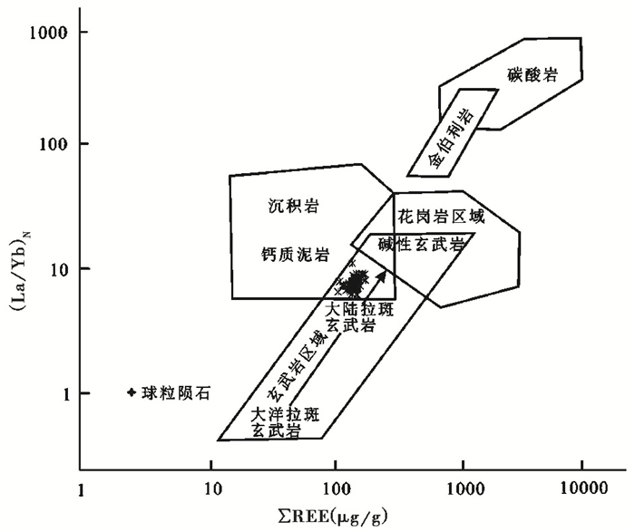
此外,将柴达木盆地多个灌丛沙丘沉积物与其他岩石的(La/Yb)N-ΣREE分布进行比较,可以发现灌丛沙丘沉积物样品投点比较集中(图 9),样品的(La/Yb)N和ΣREE值分布均落在沉积岩-钙质泥岩与玄武岩的互交区块当中,反映了其物质来源的岩石类型。有关东昆仑构造地球化学及岩石矿物学研究成果[27]显示,该构造带多由类型复杂的玄武岩组成。因此,柴达木盆地灌丛沙丘风沙沉积物所处的区块恰好表明了其主要来源于周围山地的玄武岩碎屑沉积母质,并显示出对母质的良好继承性。而相邻区域湖泊沉积物物源的研究表明,其沉积物的(La/Yb)N和ΣREE值分布主要在沉积岩-钙质泥岩区块,只有少量酸不溶的残留物来源于玄武岩物质[14],与灌丛沙丘风沙沉积物在物源上存在较大差异。综上所述,柴达木盆地灌丛沙丘沉积物应该主要是由东昆仑北麓冲积扇碎屑沉积物经过风化、搬运、沉积而成,而并非气候干旱期湖水退缩后湖底沉积物风化剥蚀堆积的产物。
|
图 9 灌丛沙丘风沙沉积物(La/Yb)N-ΣREE图解 背景值据Allegre和Minster[28] Fig. 9 The diagram of(La/Yb)N-ΣREE for nebkhas sediments, trace element background value by Allegre and Minster[28] |
风沙沉积过程是对区域风沙活动的反映[29~33],其通常被作为气候干旱化的指标[34~36]。而灌丛沙丘作为风沙沉积过程的记录载体能够很好反映区域风沙历史[37],因此,灌丛沙丘在某一时段的集中发育能够较好反映区域干旱环境状况。柴达木盆地灌丛沙丘的测年结果(表 1)表明,其发育年代较久,更能反映区域长时间尺度的风沙过程,是干旱环境的良好记录载体。为此,我们对获取的灌丛沙丘年代数据进行概率密度分布[38]分析,得出约16 ka B.P.以来灌丛沙丘发育年代分布状况(图 10),从而推测了柴达木盆地盐湖周边的风沙活动及环境状况。

|
图 10 灌丛沙丘年代概率密度曲线和北纬35°夏季辐射[39] Fig. 10 Probability density distribution of nebkhas' ages and summer insolation[39] |
分析结果(图 10)表明,柴达木盆地灌丛沙丘年龄主要分布于中、晚全新世以后,尤其是3 ka B.P.以来,很好对应了35°N夏季太阳辐射[39]逐渐减弱期;而灌丛沙丘在约12 ka B.P.的发育可能是对新仙女木(Younger Dryas)短暂冷事件[40~44]的具体响应。据此,推测全球末次冰盛期以后随气候转暖东昆仑山冰川融水携带的第四纪沉积物在山麓形成冲洪积扇沉积,为灌丛沙丘发育提供了丰富的物质基础;同时冰川融水又为植被生长提供了必备条件,植被得以发育,为灌丛沙丘发育提供了保障。随温度逐步升高、气候逐渐变干,风沙活动增强,盆地内早期的灌丛沙丘开始发育;中、晚全新世以后35°N夏季太阳辐射逐渐减弱,东亚季风强度降低不足以给柴达木盆地带来丰富的水汽形成降水,导致气候干旱,风沙活动增强,发育了大量的灌丛沙丘。
柴达木盆地东部黄土沉积研究表明中晚全新世以后气候有变干趋势[6],3.6 ka B.P.以来风沙活动尤为强烈[42];而灌丛沙丘相邻区域的别勒滩盐湖4 cal.ka B.P.以来的沉积层中均为石盐和石膏[45],表明该时期湖泊在极端干旱的气候条件下形成盐层。此外,柴达木盆地周围的其他地区如茶卡[46]、青海湖[47~49]及共和盆地[31~33]在中晚全新世以来也是全新世的最干旱阶段。同时,剖面NG1P1的REEs含量特征也反映了约2.1 ka B.P.以来的总体干旱环境。总之,柴达木盆地灌丛沙丘的发育过程是对干旱气候的响应,是末次冰盛期以后气候增温、干旱所致。
3 结论对柴达木盆地东南的诺木洪农场以东约30 km处至西南部的乌图美仁乡附近(沿昆仑山北麓的洪积扇、绿洲、湖滨湿地等灌丛沙丘广泛分布带)为研究区,进行了灌丛沙丘年代、沉积物稀土元素特征等方面的研究,并结合柴达木盆地周边区域风沙活动、古气候变化的研究成果,探讨了灌丛沙丘发育年龄及过程、物质来源及其对干旱环境的响应关系。结果如下:
(1) OSL与AMS 14C两种测年结果尽管在较长时间尺度内反映了相对一致的趋势,主要集中在全新世,尤其是中、晚全新世以后,但二者相同或相近深度的年龄存在一定差异。鉴于灌丛植被与沙丘协同增长与衰退之间非同步关系,认为AMS 14C法可能并不太适合柴达木盆地灌丛沙丘的定年。灌丛沙丘发育的高度-年龄没有明显相关趋势,表明不同灌丛沙丘沉积发育过程复杂,没有统一的深度-年龄模式;但年龄变量与深度变量之间存在Y=0.188X+0.276的方程式,其相关系数R2=0.539,置信水平为0.99%,呈极显著相关。
(2) 沉积物稀土元素表现出LREE富集,HREE丰度相对较低的特征,(La/Yb)N范围介于6.71~9.49,δEu介于0.57~0.69,δCe介于0.98~1.01,表明研究区沉积环境处于微弱的还原状况,无明显的稀土元素异常,化学风化作用与成壤作用较弱,没有发生过较为强烈的氧化-还原作用,更多的保留了其物源特征;其REEs各特征参数的垂直分异反映了不同时期区域气候环境的微小差异。(La/Yb)N-ΣREE分布的比较结果表明,研究区灌丛沙丘主要是由东昆仑北麓冲积扇碎屑物质经过风化、搬运、沉积而成,而并非气候干旱期湖水退缩后湖底沉积物风化剥蚀堆积的产物。
(3) 全球末次冰盛期以后,随气候转暖东昆仑山冰川融水携带的第四纪沉积物在山麓形成冲洪积扇沉积,为灌丛沙丘发育提供了丰富的物质基础;同时冰川融水可能促进了灌丛植被的生长,为灌丛沙丘发育提供了保障。随温度升高、气候逐渐变干,风沙活动增强,盆地内早期的灌丛沙丘开始发育形成;随气候进一步变干,至中晚全新世以后灌丛沙丘达到较大发育规模;其发育过程对35°N夏季太阳辐射强度变化、新仙女木事件有较好的反映,是对全新世干旱气候的响应。
致谢: 感谢评审专家和编辑部杨美芳老师对论文修改提出的宝贵意见和建议!
| [1] |
Chen J, Li G, Yang J et al. Nd and Sr isotopic characteristics of Chinese deserts:Implications for the provenances of Asian dust. Geochimica et Cosmochimica Acta, 2007, 71(15): 3904-3914. DOI:10.1016/j.gca.2007.04.033 |
| [2] |
Li G J, Chen J, Ji J F et al. Natural and anthropogenic sources of East Asian dust. Geology, 2009, 3(8): 727-730. |
| [3] |
张小曳. 亚洲粉尘的源区分布、释放、输送、沉降与黄土堆积. 第四纪研究, 2001, 21(1): 29-40. Zhang Xiaoye. Source distributions, emission, transport, deposition of Asian dust and loess accumulation. Quaternary Sciences, 2001, 21(1): 29-40. |
| [4] |
杨帅斌, 乔彦松, 彭莎莎等. 青藏高原东北缘黄土的地球化学特征及其对物源和风化强度的指示意义. 第四纪研究, 2017, 37(1): 1-13. Yang Shuaibin, Qiao Yansong, Peng Shasha et al. Geochemical characteristics of eolian deposits in the northeastern margin of the Tibetan Plateau and implications for provenance and weathering intensity. Quaternary Sciences, 2017, 37(1): 1-13. |
| [5] |
Pullen A, Kapp P, McCallister A T et al. Qaidam Basin and northern Tibetan Plateau as dust sources for the Chinese Loess Plateau and paleoclimatic implications. Geology, 2011, 39(11): 1031-1034. DOI:10.1130/G32296.1 |
| [6] |
Yu L P, Lai Z P. OSL chronology and palaeoclimatic implications of aeolian sediments in the Qaidam Basin of the northeastern Qinghai-Tibetan Plateau. Palaeogeography, Palaeoclimatology, Palaeoecology, 2012, 337-338: 120-129. DOI:10.1016/j.palaeo.2012.04.004 |
| [7] |
Yu L P, Lai Z P, An P. OSL chronology and paleoclimatic implications of paleodunes in the middle and southwestern Qaidam Basin, Qinghai-Tibetan Plateau. Sciences in Cold and Arid Regions, 2013, 5(2): 211-219. DOI:10.3724/SP.J.1226.2013.00211 |
| [8] |
Yu L P, Lai Z P. Holocene climate change inferred from stratigraphy and OSL chronology of aeolian sediments in the Qaidam Basin, northeastern Qinghai-Tibetan Plateau. Quaternary Research, 2014, 81(3): 488-499. DOI:10.1016/j.yqres.2013.09.006 |
| [9] |
伍光和, 张志良, 胡双熙等. 柴达木地盆地. 兰州: 兰州大学出版社, 1990: 37-57. Wu Guanghe, Zhang Zhiliang, Hu Shuangxi et al. Qaidam Basin. Lanzhou: Press of Lanzhou University, 1990: 37-57. |
| [10] |
曾永年, 冯兆东, 曹广超. 末次冰期以来柴达木盆地沙漠形成与演化. 地理学报, 2003, 58(3): 452-457. Zeng Yongnian, Feng Zhaodong, Cao Guangchao. Desert formation and evolution in Qaidam Basin since the Last Glacial Epoch. Acta Geographica Sinica, 2003, 58(3): 452-457. DOI:10.11821/xb200303015 |
| [11] |
钟泽兵, 周国英, 杨路存等. 柴达木盆地几种荒漠灌丛植被的生物量分配格局. 中国沙漠, 2014, 34(4): 1042-1048. Zhong Zebing, Zhou Guoying, Yang Lucun et al. The biomass allocation patterns of desert shrub vegetation in the Qaidam Basin, Qinghai, China. Journal of Desert Research, 2014, 34(4): 1042-1048. DOI:10.7522/j.issn.1000-694X.2013.00406 |
| [12] |
孔芳芳, 谭利华, 伍永秋等. 柴达木盆地不同沉积区灌丛沙堆形态与沉积特征. 北京师范大学学报(自然科学版), 2016, 52(1): 56-62. Kong Fangfang, Tian Lihua, Wu Yongqiu et al. Morphology and sediments of nabkha in Qaidam Basin. Journal of Beijing Normal University (Natural Science), 2016, 52(1): 56-62. |
| [13] |
陈秀玲, 李金婵, 方红等. 末次冰期以来新疆伊犁黄土的稀土元素特征及环境演变. 第四纪研究, 2017, 37(1): 14-24. Chen Xiuling, Li Jinchan, Fang Hong et al. Rare earth element characteristics and environmental changes recorded by loess deposition in the Ili Basin since the last glaciation. Quaternary Sciences, 2017, 37(1): 14-24. |
| [14] |
Zhang H C, Zhang W X, Chang F Q et al. Geochemical fractionation of rare earth elements in lacustrine deposits from Qaidam Basin. Science in China (Series D):Earth Sciences, 2009, 52(11): 1703-1713. DOI:10.1007/s11430-009-0097-9 |
| [15] |
陈秀玲, 李志忠, 贾丽敏等. 新疆伊犁河谷沙漠沉积的稀土元素特征及其环境意义. 第四纪研究, 2013, 33(2): 368-375. Chen Xiuling, Li Zhizhong, Jia Limin et al. Rare earth element characteristics of desert sediments in Ili valley and their environmental implication. Quaternary Sciences, 2013, 33(2): 368-375. |
| [16] |
Hao Q Z, Guo Z T, Qiao Y S et al. Geochemical evidence for the provenance of Middle Pleistocene loess deposits in Southern China. Quaternary Science Reviews, 2010, 29(23~24): 3317-3326. |
| [17] |
邱思静, 陈一凡, 王振等. 天山北麓乌鲁木齐河阶地晚更新世黄土磁学特征及古气候意义. 第四纪研究, 2016, 36(5): 1319-1330. Qiu Sijing, Chen Yifan, Wang Zhen et al. Rock magnetic properties and paleoclimatic implications of Late Pleistocene loess in the range front of the Árümqi River, Xinjiang, NW China. Quaternary Sciences, 2016, 36(5): 1319-1330. |
| [18] |
侯顺民, 刘秀铭, 吕镔等. 土耳其Nallihan黄土-古土壤岩石磁学特征及其环境意义. 第四纪研究, 2015, 35(4): 1006-1019. Hou Shunmin, Liu Xiuming, Lü Bin et al. Rock magnetic properties of loess in Nallihan, Turkey and its enviromental significances. Quaternary Sciences, 2015, 35(4): 1006-1019. |
| [19] |
时兴合, 赵燕宁, 戴升等. 柴达木盆地40多年来的气候变化研究. 中国沙漠, 2005, 25(1): 123-128. Shi Xinghe, Zhao Yanning, Dai Sheng et al. Research on climatic change of Qaidam Basin since 1961. Journal of Desert Research, 2005, 25(1): 123-128. |
| [20] |
Roberts H M. Assessing the effectiveness of the double-SAR protocol in isolating a luminescence signal dominated by quartz. Radiation Measurements, 2007, 42(10): 1627-1636. DOI:10.1016/j.radmeas.2007.09.010 |
| [21] |
Lai Z P, Brückner H. Effects of feldspar contamination on equivalent dose and the shape of growth carve for OSL of silt-sized quartz extracted from Chinese loess. Geochronometria, 2008, 30(1): 49-53. |
| [22] |
Murray A S, Wintle A G. Luminescence dating of quartz using an improved single-aliquot regenerative-dove protocol. Radiation Measurement, 2000, 32(1): 57-73. DOI:10.1016/S1350-4487(99)00253-X |
| [23] |
Linick W, Damon P E, Donahue D J et al. Accelerator Mass Spectrometry:The new revolution in radiocarbon dating. Quaternary International, 1989, 1(89): 1-6. |
| [24] |
Hedges R E M, Klinken G J V. A review of current approaches in the pretreatment of bone for radiocarbon dating by AMS. Radiocarbon, 2016, 34(3): 279-291. |
| [25] |
任纪舜, 牛宝贵, 王军等. 1!500万国际亚洲地质图. 地球学报, 2013, 34(1): 24-30. Ren Jishun, Niu Baogui, Wang Jun et al. 1!5 Million International Geological Map of Asia. Acta Geoscientica Sinica, 2013, 34(1): 24-30. DOI:10.3975/cagsb.2013.01.03 |
| [26] |
李志忠, 武胜利, 王晓峰等. 新疆和田河流域柽柳沙堆的生物地貌发育过程. 地理学报, 2007, 62(5): 462-470. Li Zhizhong, Wu Shengli, Wang Xiaofeng et al. Bio-geomorphologic growth process of Tamarix nabkha in the Hotan River basin of Xinjiang. Acta Geographica Sinica, 2007, 62(5): 462-470. DOI:10.11821/xb200705002 |
| [27] |
李瑞保, 裴先治, 李佐臣等. 东昆仑南缘布青山构造混杂带得力斯坦南MOR型玄武岩地质、地球化学特征及岩石成因. 地球科学——中国地质大学学报, 2015, 40(7): 1148-1162. Li Ruibao, Pei Xianzhi, Li Zuochen et al. Geological and geochemical features of delisitannan basalts and their petrogenesis in Buqingshang tectonic mélange belt, southern margin of East Kunlun Orogen. Earth Science-Journal of China University of Geosciences, 2015, 40(7): 1148-1162. |
| [28] |
Allegre C J, Minster J F. Quantitative models of trace element behavior in magmatic processes. Earth and Planetary Science Letters, 1978, 38(1): 1-25. DOI:10.1016/0012-821X(78)90123-1 |
| [29] |
张德国, 杨小平. 沙丘形态动力学数值模拟:以真实空间元胞自动机模型(ReSCAL)为例. 第四纪研究, 2017, 37(2): 368-379. Zhang Deguo, Yang Xiaoping. Numerical simulation on sand dune morphodynamic:A case study of ReSCAL model. Quaternary Sciences, 2017, 37(2): 368-379. |
| [30] |
丁峰, 唐进年, 苏志珠等. 库姆塔格沙漠东南缘BL砂黄土剖面的沉积过程与物源分析. 第四纪研究, 2017, 37(1): 36-44. Ding Feng, Tang Jinnian, Su Zhizhu et al. Deposited process and provenance analysis of BL sand loess section in southeastern margin of the Kumtagh Desert. Quaternary Sciences, 2017, 37(1): 36-44. |
| [31] |
Qiang M R, Jin Y X, Liu X X et al. Late Pleistocene and Holocene aeolian sedimentation in Gonghe Basin, northeastern Qinghai-Tibetan Plateau:Variability, processes, and climatic implications. Quaternary Science Reviews, 2016, 132: 57-73. DOI:10.1016/j.quascirev.2015.11.010 |
| [32] |
Qiang M R, Song L, Jin Y X et al. A 16-ka oxygen-isotope record from Genggahai Lake on the northeastern Qinghai-Tibetan Plateau:Hydroclimatic evolution and changes in atmospheric circulation. Quaternary Science Reviews, 2017, 162: 72-87. DOI:10.1016/j.quascirev.2017.03.004 |
| [33] |
李渊, 强明瑞, 王刚刚等. 晚冰期以来共和盆地更尕海碎屑物质输入过程与气候变化. 第四纪研究, 2015, 35(1): 160-171. Li Yuan, Qiang Mingrui, Wang Ganggang et al. Processes of exogenous detrital input to Genggahai Lake and climatic changes in the Gonghe Basin since the late glacial. Quaternary Sciences, 2015, 35(1): 160-171. |
| [34] |
朱震达, 吴正, 刘恕等. 中国沙漠概论. 北京: 科学出版社, 1980: 1-105. Zhu Zhenda, Wu Zheng, Liu Shu et al. Introduction to the Desert in China. Beijing: Science Press, 1980: 1-105. |
| [35] |
刘东生等. 黄土与环境. 北京: 科学出版社, 1985: 303-336. Liu Tungsheng et al. Loess and Environment. Beijing: Science Press, 1985: 303-336. |
| [36] |
Yang X P, Scuderi L Paillou P et al. Quaternary environmental changes in the drylands of China-A critical review. Quaternary Science Reviews, 2011, 30(23-24): 3219-3233. DOI:10.1016/j.quascirev.2011.08.009 |
| [37] |
郎丽丽, 王训明, 花婷等. 蒙古高原东南缘现代灌丛沙丘的发育过程及其对沙漠化的指示意义. 第四纪研究, 2013, 33(2): 325-333. Lang Lili, Wang Xunming, Hua Ting et al. Nebkha formation and its significance to desertification reconstructions in the southeastern Mongolia Plateau. Quaternary Sciences, 2013, 33(2): 325-333. |
| [38] |
Lang A. Phases of soil erosion-derived colluviation in the loess hills of South Germany. Catena, 2003, 51(3-4): 209-221. DOI:10.1016/S0341-8162(02)00166-2 |
| [39] |
Berger A, Loutre M F. Isolation values for the climate of the last 10 million years. Quaternary Science Reviews, 1991, 10(4): 297-317. DOI:10.1016/0277-3791(91)90033-Q |
| [40] |
刘嘉麒, 倪云燕, 储国强. 第四纪的主要气候时间. 第四纪研究, 2001, 21(3): 239-248. Liu Jiaqi, Ni Yunyan, Chu Guoqiang. Main palaeoclimatic events in the Quaternary. Quaternary Sciences, 2001, 21(3): 239-248. |
| [41] |
刘嘉丽, 刘强, 储国强等. 大兴安岭四方山天池15.4 ka B.P.以来湖泊沉积记录. 第四纪研究, 2015, 35(4): 901-912. Liu Jiali, Liu Qiang, Chu Guoqiang et al. Sediment record at Lake Sifangshan in the central-northern part of the Great Xing'an range, Northeast China since 15.4 ka B.P.. Quaternary Sciences, 2015, 35(4): 901-912. |
| [42] |
Stauch G. Geomorphological and palaeoclimate dynamics recorded by the formation of aeolian archives on the Tibetan Plateau. Earth-Science Reviews, 2015, 150(2): 393-408. |
| [43] |
刘晶晶, 张江勇, 陈云如等. 基于叶蜡正构烷烃重建的南海及周边地区植被类型. 第四纪研究, 2016, 36(3): 553-563. Liu Jingjing, Zhang Jiangyong, Chen Yunru et al. Vegetation changes recorded by leaf-wax n-alkanes around the South China Sea. Quaternary Sciences, 2016, 36(3): 553-563. |
| [44] |
汪亘, 王永莉, 孟培等. 东北地区五大连池湖相沉积物正构烷烃和单体碳同位素特征及其古植被意义. 第四纪研究, 2015, 35(4): 890-900. Wang Gen, Wang Yongli, Meng Pei et al. Chemical and compound-specific carbon isotopic characteristics of n-alkanes in the Qingshi lacustrine sediments, Wudalianchi, Northeast China, and their paleovegetation significances. Quaternary Sciences, 2015, 35(4): 890-900. |
| [45] |
Huang Q, Cai B Q, Yu J Q. The 14C age and cycle of sedimentation of some saline lakes on the Qinghai-Xizang Plateau. Chinese Science Bulletin, 1981, 26(1): 66-70. |
| [46] |
Liu X Q, Dong H L, Rech J A et al. Evolution of Chaka Salt Lake in NW China in response to climatic change during the Latest Pleistocene-Holocene. Quaternary Science Reviews, 2008, 27(7-8): 867-879. DOI:10.1016/j.quascirev.2007.12.006 |
| [47] |
Lister G, Kelts K, Chen K Z et al. Lake Qinghai, China:Closed-basin lake levels and the oxygen isotope record for ostracoda since the Latest Pleistocene. Palaeogeography, Palaeoclimatology, Palaeoecolyogy, 1991, 84: 141-162. DOI:10.1016/0031-0182(91)90041-O |
| [48] |
Shen J, Liu X Q, Wang S M et al. Palaeoclimatic changes in the Qinghai Lake area during the last 18000 years. Quaternary International, 2005, 136(1): 131-140. DOI:10.1016/j.quaint.2004.11.014 |
| [49] |
Liu X Q, Shen J, Wang S M et al. Southwest monsoon changes indicated by oxygen isotope of ostracode shells from sediments in Qinghai Lake since the late glacial. Chinese Science Bulletin, 2007, 52(4): 539-544. DOI:10.1007/s11434-007-0086-3 |
2 Key Laboratory of Western China's Environmental System(Ministry of Education), College of Earth Environmental Sciences, Lanzhou University, Lanzhou 730000, Gansu;
3 CAS Center for Excellence in Tibetan Plateau Earth Sciences, Beijing 100101)
Abstract
The Qaidam Basin is located in the northeastern part of the Qinghai-Tibet Plateau, which has an extremely cold and dry environment. The Qaidam Basin is considered to be one of the highest and most arid desert on the earth, which is the main dust source area of the Loess Plateau during Quaternary glaciation and glacial substage. Due to the strong sandstorm activity in the Qaidam Basin, there are many types of sand sedimentary geomorphology, such as ancient dunes, nebkhas, etc. The extensively developed nebkhas are found in many parts of the Qaidam Basin, which height are from a few meters to more than ten meters. The nebkhas are mainly distributed along the northern foothills of the East Kunlun Mountains, which is a zonal region from the east to the west(36°15'~36°55'N, 93°20'~96°50'E). The nebkhas and the other aeolian landforms were be considered that their sand source were the sediments of the lake, and the aeolian sediments from lake bottom weathered and eroded, transported, and then accumulated in the edge of the basin. The aeolian sand develops a large number of sandy landform types, but there is not a necessary evidence of the sediments source. In addition, the chronology of nebkhas, the sandy material source of nebkhas, and their response to the climate and sandstorm activities are not clearly known around salt lakes in the Qaidam Basin. In this study, the chronology of nebkhas, and the rare earth elements(REEs) characteristics of the aeolian sediments from the nebkhas were studied around salt lakes in the Qaidam Basin. We also compared the environment recorded by nebkhas with the research results of the sandstorm activities and the paleoclimatic reports in the surrounding areas of the Qaidam Basin. The relationship between the age and the development processes of these nebkhas have been studied by us. And the sedimentary material source of the nebkhas and their response to arid environment are discussed too. The results show that the nebkhas in the Qaidam Basin have developed after the Last Glacial Maximum(LGM). As the climate getting dry gradually, the nebkhas have reached the larger scale since the Middle and Late Holocene. The changes of the summer insolation at 35°N and the Younger Dryas event are recorded by the nebkhas, which formation and development are the response to the Holocene arid climate. There is a significant correlation between the age variation and the depth variation of the nebkhas, and the equation is Y=0.188X+0.276 with the correlation coefficient R2=0.539 which confidence level is 0.99%. The REE values vary from 119.72 μg/g to 154.39 μg/g with the value 6.70~8.39 of LREE/HREE ratios. The values of(La/Yb)N vary from 6.71 to 9.49, and the values of the δEu and the δCe are 0.57~0.69 and 0.98~1.01, respectively. The(La/Yb)N-ΣREE values show that the sand sources of the nebkhas are the alluvial fan detritus sediments which are from the northern foothills of the East Kunlun Mountains. After the Last Glacial Maximum in the world, the Quaternary sediments were carried by the melting water to the foothills of East Kunlun Mountains, which became the alluvial fan debris, and then through the weathering, handling, deposition process, providing a rich material basis for the development of nebkhas. Therefore, the sedimentary material source of the nebkhas is not the weathering erosive of the lake sediments, which were exposed to the lake bottom after the lake shrinking caused by climate drought. In addition, the glacier meltwater may provide the necessary conditions for vegetation growth, and then, the vegetation development has provided the guarantee for the development of nebkhas around the salt lakes in the Qaidam Basin. 2018, Vol.38

