② 中国地质调查局西安地质调查中心, 西安 710054;
③ 中国科学院地球环境研究所, 黄土与第四纪国家重点实验室, 西安 710061)
沙漠物源研究对揭示风沙搬运机制、预测粉尘输出及指导当地治沙具有重要意义[1, 2]。库布齐沙漠物源研究对理解其沙漠景观的形成机理及其环境意义具有重要的作用。位于鄂尔多斯高原北部的库布齐沙漠是中国第七大沙漠,也是中国北方干旱半干旱地区唯一具有大规模活动沙丘的沙漠[3]。库布齐沙漠风沙活动最剧烈的区段每年以大于1km的幅度向外扩展[4],是我国沙漠化最严重地区,并已成为我国主要的沙尘源区之一[5, 6]。前人对库布齐沙漠的形成年龄和成因进行了研究,认为库布齐沙漠的形成是末次冰期以来气候干旱和人类频繁活动共同作用的结果[3, 7~9],现今的沙漠格局是在距今2.2ka以来最终才形成的[8]。已有的研究对库布齐沙漠物质的源区也存在不同的认识。如,Chen等[10]通过Sr、Nd同位素分析认为本区风沙主要来自周缘山区;杨杰东等[11]用同样的手段发现本区风沙与下伏古老基底物质存在物源关系;闫德仁[9]则认为周缘山脉形成的山前冲洪积物和下伏河湖相沉积物是本区风沙的主要物源;Yang等[3]通过沙漠多个剖面的地层和光释光年龄研究揭示,黄河在河套地区曾不断改道,可能为库布齐沙漠的潜在物源。最新研究显示,黄河为位于库布奇沙漠南部的毛乌素沙地的重要物源之一[12, 13]。然而,黄河能否为库布齐沙漠提供物源还有待更多证据发现。此外,最新研究发现,一些沙漠的物源存在较明显的空间差异,如毛乌素沙漠[13]、巴丹吉林沙漠[14]等。对于库布齐沙漠内部是否也具有物源的空间分异性也有待研究。
单颗粒锆石U-Pb定年示踪技术是目前沉积物源区研究的有力工具[15~19]。锆石广泛分布于各类岩石和沉积物中,并且锆石抵抗风化、磨蚀和热蚀变的能力强,在沉积循环中不易破坏,从而可以很好地保留源区岩石的年代学和成因信息[20~23]。相对于同位素法测试全样或部分全样提供的均一化信号[1],锆石U-Pb年龄谱可较为精准地反映源区岩石的年代和造岩信息,具有更大的示踪优势。本文通过对比库布齐沙漠沙样与周围潜在源区物质的碎屑锆石U-Pb年龄谱,同时结合沉积物的光释光测年,从时间和空间上深入探讨库布齐沙漠的物源。
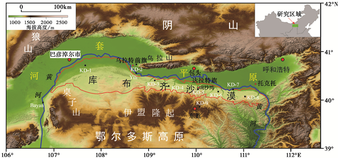
2 区域背景库布齐沙漠位于鄂尔多斯高原伊盟隆起以北向河套平原的过渡坡面上,地势北低南高,东、北和西三面均为黄河所环绕,总体呈东西向狭长带状,东西长400km,东部宽20~30km,西部宽约100km,像一根挂在黄河上的弦(图 1)。库布齐沙漠基底主要为湖相沉积、全新世冲积扇、黄河阶地及鄂尔多斯中生代地层[3, 8, 9]。库布齐沙漠地处东亚夏季风边缘[24],年降水量为200~450mm,属干旱半干旱地区[25]。该沙漠的东部地区有十条季节性河流(十大孔兑,蒙语)从南部隆起区向北汇入黄河[26]。库布齐沙漠西部南北宽度大,面积分布广,并发育从几米到几十米不等的沙丘。中部响沙湾附近以流动沙丘为主,沙丘最高可达80~100m [27];东部沙漠南北分布较窄,但依然有几米到几十米高度的活动沙丘发育。
|
图 1 研究区数字高程图和采样位置 蓝色线条为黄河;红色线条范围为库布齐沙漠;黑色实心点为采样位置;样品Bayan和样品Yili引自文献[12] Fig. 1 DEM map of the studied area and the sampling sites. Blue line indicates Yellow River; the region enclosed by the red line is Hobq Desert; black solid points are simple sites. Samples of Bayan and Yili are from reference [12] |
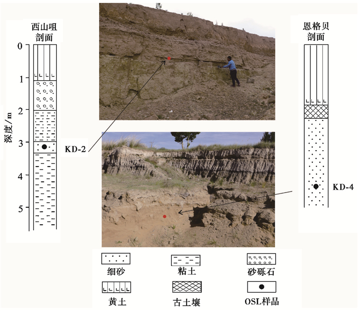
通过野外地质考察,本研究沿东西走向在库布齐沙漠布置了9个采样点,样品性质、样品位置和采样信息见图 1和表 1。为了分析和讨论库布奇沙漠东西方向上的物源变化,采样点分别布置于沙漠东部、中部和西部。表 1中除了本次工作9个采样点外,还列出了前人的采样点Yili [12]和Bayan [12]。在上述9个点各采集1个散样用于锆石物源分析。前人研究发现,库布齐沙漠的风沙层直接覆盖于湖相或冲积层之上,与该区域发育的吉兰泰-河套古湖呈上下叠覆关系[8]。为确定下伏湖相地层是否可能为库布齐沙漠的潜在物源,在沙漠西部乌拉特前旗地区和沙漠东部恩格贝景区选取了两个湖相剖面,即西山咀剖面和恩格贝剖面进行研究(图 2)。西山咀剖面(KD-2) 位于乌拉特前旗西山咀砖厂南侧,剖面出露厚约4m,主体为典型的湖相沉积,下部呈浅灰绿色砂质粘土或粘土质粉砂,向上过渡为细砂、中砂、红色泥砾岩,顶部为厚约1.1m的风成堆积物,为浅湖相向滨湖相、冲洪积相及风成沙过渡序列;在剖面深约3.2m处(滨湖相中细砂)采集光释光测年样品(KD-2),平行采集碎屑锆石U-Pb测年样品。恩格贝剖面(KD-4) 位于恩格贝景区,剖面出露厚约5m;下部为浅黄色中细砂,见有平行层理,中部为厚约0.4m的沙质粘土,上部为现代风沙层。沉积序列为滨湖相中-细沙、滨岸带沼泽土壤及上覆现代风成沙黄土;在深约4.5m处滨湖相沙层采集光释光样品(KD-4) 和碎屑锆石U-Pb测年样品。
| 表 1 样品信息 Table 1 Sample details |
|
图 2 库布齐沙漠KD-2和KD-4湖相沉积剖面 Fig. 2 The lake sections of KD-2 and KD-4 of Hobq Desert |
OSL样品采集于新开挖的剖面,通过一端密封的不锈钢管沿水平方向打入取得。采样管取出后迅速密封两端,以避免曝光及水分散失。
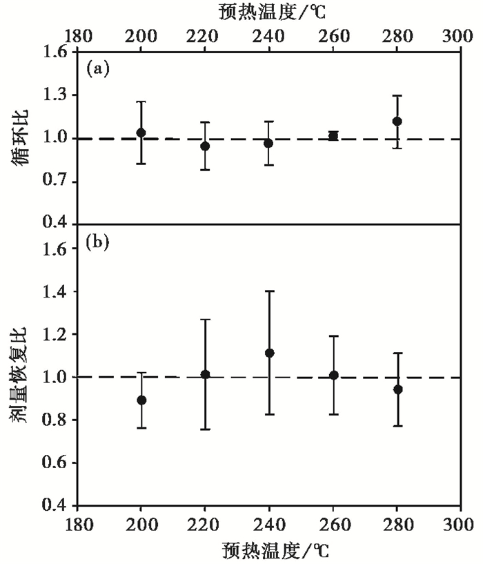
OSL测年基于等效剂量De值与剂量率之间的比值计算沉积年龄。通常情况下,相对于长石,石英光释光信号更容易晒退且不存在异常衰退[28]。因此,本文采用石英矿物组分测量等效剂量。样品制备和等效剂量(De)测量在西北大学光释光实验室完成。测试仪器为丹麦生产的Risø TL/OSL-DA-20热释光/光释光测量仪。纯净石英颗粒的制备在波长为655±30nm红光环境中完成,首先从全样中筛取94~105μm粒级区间颗粒,经双氧水和盐酸反应去除有机质和钙质,依次经重液2.62g/cm3和2.75g/cm3,复选获得石英。用浓度40 %的氢氟酸经磁力震荡搅拌40分钟以充分溶蚀石英颗粒表面约10μm范围内受α粒子的影响的部分以及可能残留的长石[29]。处理好的石英颗粒用硅油粘在直径1cm不锈钢片中心区域2mm(small aliquot)。测试前经过红外光照射检验样片中石英的纯净度,对无明显的红外释光信号的样片进行De测试。等效剂量测试采用单片再生剂量法(SAR) [30]。由于De值的可靠性与预热温度关系密切[31, 32],对每个样品都进行了预热坪实验,最终选取260℃为最佳预热温度条件测试De(图 3)。
|
图 3 代表性样品KD-4的剂量恢复实验结果 (a)循环比(Recycling ratio);(b)剂量恢复比(单个测片的剂量恢复结果)(Dose recovery ratio for one aliquot) Fig. 3 Results of dose recovery tests of the representative sample KD-4 |
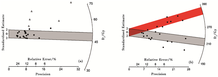
挑选测试结果同时满足以下两个条件的样片进行统计分析[8, 33]:1) 循环比(Recycling ratio)介于0.9~1.1;2) 回授光释光信号小于天然信号的5 %。每个样品选20片以上合格样片进行等效剂量(De)的统计(图 4)。KD-4雷达图显示在相对集中的De区域外,还有少量样品较为分散。KD-2分散程度更大些,这可能与湖相样品水下曝光不足有关,也有可能是细颗粒下渗有关[34]。De分散可能造成这两个湖相样品年龄误差范围较大。年剂量率根据放射性元素含量[35]、宇宙射线[36]、含水量的影响计算得出。由于地层中含水量是不断变化的,本研究根据实验室中测得的天然含水量及饱和含水量估计了埋藏期间样品平均含水量,U、Th和K含量采用等离子质谱仪和X荧光光谱仪分别测试。
|
图 4 KD-4 (a)和KD-2 (b)样品的De值雷达分布图 Fig. 4 Radial plot of De values for samples of KD-4 (a)and KD-2 (b) |
碎屑锆石U-Pb测年在西北大学大陆动力学国家重点实验室完成。根据Vermessch [37]对碎屑锆石数量的要求,每个样品随机挑选100个锆石颗粒,所有样品共测试900个点。锆石的U-Pb同位素用配有GeoLas200M 193nm ArF准分子激光器的LA-ICP-MS系统测试,详细的分析参数见Yuan等[38]。元素含量、同位素比值和年龄采用Glitter 4.0(Macquarie University)软件计算,并用Density Plotter方法[39]绘制年龄图谱。一般而言,由于受U浓度和普通Pb污染的影响,对于206 Pb/238 U年龄<1000Ma的锆石颗粒,年龄的谐和度一般采用207 Pb/235 U年龄与206 Pb/238 U年龄相对百分差计算,并以206 Pb/238 U年龄作为锆石样品年龄。对于206 Pb/238 U年龄>1000Ma的样品,年龄谐和度采用207 Pb/206 Pb年龄与206 Pb/238 U年龄的相对百分差计算,并以207 Pb/206 Pb年龄作为锆石样品年龄。碎屑锆石年龄谱的分析去除不谐和度超过±10 %的数据。
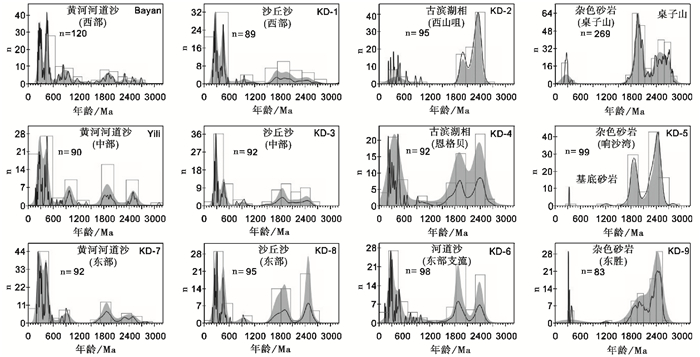
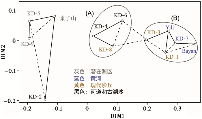
如图 5中12组碎屑锆石U-Pb年龄谱所示,仅通过对比年龄谱判断物质之间联系的人为主观因素较大。为了进一步厘清各个样品之间的关系,本研究采用多维标度分析法(Multi-dimensional Scaling,简写为MDS),从而更为直观展现样品之间的关系(图 6)。MDS是一种经典的数据降维方法,同时也是数据可视化的一种有效手段。当n个对象中各对象之间的在多纬空间的相似性(或距离)给定时,MDS可以确定这些对象在低维空间中的表示,并使其在低维空间的距离尽可能与原先的相似性(或距离)“匹配”。Vermessch [42]最先将这种方法用于对比碎屑锆石的年龄分布,并用Kolmogorov-Smirnov(KS)统计方法表征样品间碎屑锆石年龄谱的差异。该方法也被之后的锆石U-Pb年龄对比研究所广泛应用[13, 43~45]。本文也采用Vermeesch等[46]基于R语言编程的Provenance软件绘制样品间相似度的MDS图(图 6)。
|
图 5 样品的锆石U-Pb年龄谱图 黑色线和灰色阴影分别为概率密度分布曲线(PDP)和核密度分布(KDEs);空心矩形为年龄直方图;n为谐和年龄个数样品Bayan和样品Yili引自文献[12];桌子山数据引自文献[58, 59] Fig. 5 Zircon U-Pb age population of the samples. Black lines and gray shades are normalized probability density plot(PDP)and kernel density estimation(KDE)plots, respectively, the open rectangles are age histograms, n is the number of concordant ages, samples of Bayan and Yili are from reference[12], and the data of Zhuozi Mountain is from references[58, 59] |
|
图 6 非度量多维标度分析图(MDS) 实线代表各样品之间具有直接相关关系;虚线表示间接相关关系;灰色椭圆(A)表示现代库布齐东部沙丘和第四纪河流、湖泊沙样,(B)表示现代库布齐西部沙丘和黄河沙样 Fig. 6 Non-metric multi-dimensional scaling(MDS)plots. Solid lines indicate the closest neighbors and dashed lines indicate the second closest neighbors. Grey ellipses enclose all modern and Quaternary samples from (A)the east Hobq and (B)the west Hobq |
近年来,OSL技术被广泛应用于我国干旱/半干旱区第四纪沉积物的测年研究[47~50]。两个古湖相样品KD-2和KD-4的OSL年龄分别为62.1±8.9ka和22.4±2.4ka(表 2)。其中KD-2年龄与范天来等[51]在西山咀地区同一地层附近测得的年龄(64.7±5.4ka)较为接近。陈发虎等[24, 52]研究认为,“吉兰泰-河套”古大湖开始形成于距今10万年前后,在距今5~6万年时仍然存在,是淹没河套平原大部分地区的巨大湖泊,并在其后开始衰退。库布齐沙漠风成沙年龄数据较为丰富,Li等[53]在库布齐沙漠一个近10m厚的风沙剖面测得底部光释光数据为11500±1000a;Yang等[3]在库布齐沙漠完成了14个地点的风成沙OSL测量,底部最老年龄在7500a左右;范育新等[8]根据5条南北向断面上的12个探坑和剖面获得的OSL数据认为库布齐沙漠的西北部和东部地区最迟分别在距今19ka和9ka前后开始风沙堆积,在距今7ka风沙活动显著增强,特别是在距今2ka以来受到人类活动的影响沙漠向南和北扩展,现代库布齐沙漠景观开始形成。从前人大量的沙漠沙和古湖沉积年龄数据可以看出,最老的风沙活化年龄不老于古湖的消亡年龄,并且区域地层上也显示古湖沉积之上覆盖风成沙的叠置关系,为探讨古湖消亡与沙漠形成之间的关系提供了年代支撑。
| 表 2 OSL测年结果 Table 2 The results of OSL dating |
锆石U-Pb年龄谱传统上多采用概率密度分布曲线绘制(Probability density plotter,简写为PDP) [54],然而Galbraith[55, 56]、Vermeesch [39]等发现用PDP年龄谱会产生离散的和不连续的峰值,并由于峰值较为尖锐,容易产生不真实的干扰峰。采用Silverman [57]的核密度(Kernel Density Estimators,简写为KDEs)绘制的锆石年龄谱较为平滑和连续,更能反映出年龄真实谱峰。但是,PDP曲线具有捕捉到数值较小的峰值的优点。为较为全面地反映锆石年龄谱,本文采用Density Plotter方法[39]绘制出两种曲线便于对比(图 5)。
对比发现,库布齐沙漠沙丘沙样(KD-1、KD-3和KD-8) 具有相似的锆石年龄峰,峰值年龄主要集中在2.5Ga、1.9Ga、960Ma、450Ma及280Ma等5个峰值。中部沙漠区下覆于响沙湾流沙的白垩纪基底砂岩(KD-5) 却缺少峰值年龄为960Ma和450Ma的锆石,这种几乎只出现老锆石(>1.4 Ga占97.9 %)的物源构成与沙漠西南缘桌子山[58, 59]和中南部沙漠区东胜地区广泛出露的中生代砂岩(KD-9) 一致。对比基岩与沙漠沙锆石图谱可以看出库布奇沙漠周边基岩与沙漠沙的物质组成不完全一致。由此推断,沙漠南部隆起区和基底古老岩石不是本区沙漠物质的唯一源区。相比之下,库布齐3个沙丘沙样与流经本区的现代黄河的河道沙样(Bayan [12]、Yili [12]和KD-7) 锆石年龄谱具有很高的相似性,特别是960Ma、450Ma及280Ma年轻锆石年龄峰值非常相似。因此,黄河携带物质很可能是库布齐沙漠不能忽视的另一重要物质来源,它将黄河上游(远源)年轻物质搬运至沙漠地区。进一步仔细对比发现,沙样中>1.4Ga的古老锆石组分从自西向东逐渐增加(KD-1:34.4 %;KD-3:42.4 %;KD-8:56.8 %);同时,< 450Ma的年轻锆石自西向东逐渐减少(KD-1:41.6 %;KD-3:40. 2 %;KD-8:28.4 %),可能反映了库布齐沙漠东部地区本地物质的贡献大,而库布齐沙漠西部地区黄河沉积物的贡献较大。
对比古湖沉积与上覆的风成沙物源关系有助于厘清沙漠最直接的物质来源,是理解古湖盆对近源和远源物质能否起到汇聚作用的有效途径[60]。陈发虎等[24, 52]认为河套古湖范围与现今沙漠分布有部分重叠,本文在此基础上试图分析河套古湖沉积物与上覆沙漠沙的物源关系。滨湖相样品KD-4位置远离山前,位于河套古湖靠近黄河河道的位置。其中>1.4 Ga的古老锆石和年轻锆石几乎各占一半,其组成与沙漠沙锆石非常相似(图 5)。KD-4样品的960Ma、450Ma年轻锆石含量显著增加(图 5),原因可能是古湖当时为黄河河道的一部分,既有从上游带来的年轻物质,也有黄河支流从周边山区带来的古老锆石。伴随湖盆消失,湖相沉积物的暴露、风化、风力搬运和分选有可能为附近沙漠提供物源。而位于西山咀的KD-2样品锆石年龄谱以老锆石为主(1.9~2.4Ga),960Ma和450Ma锆石年龄含量很少,显示西山咀湖相沉积锆石年龄谱与西部沙漠沙锆石年龄谱区别较大,指示了西部地区湖相沉积不是沙漠主要物源,而黄河携带的物质才是西部沙漠沙的主要物源。
上述观察结果在MDS图中也可以得到很好的验证(图 6)。库布齐沙漠与南部隆起区和下伏基底白垩纪砂岩没有直接的关系。在库布齐沙漠内部,现代沙丘样品也明显地分成两个区域:KD-1和KD-3沙样与黄河河道沙关系密切,表明库布齐中西部沙漠沙可能主要来自于黄河河道携带的物质;东部现代沙丘(KD-8) 则与下伏古湖沙样(KD-4) 和本地河流沙(KD-6) 关系密切,处于黄河物质与基岩物质之间,可能代表了混合物源。Fan等[61]通过Sr同位素示踪认为河套古湖在高湖位阶段的主要供水源来自于黄河,而在低湖位阶段主要来自于当地降雨和地表水。因此,河套古湖沉积物来自南部隆起区古老基岩与黄河物质的混合。古湖消亡后,细粒物质经风力搬运至下风区,而粗粒物质残留下来为现代库布齐沙漠提供物源。
Li等[60]通过河套盆地钻孔资料发现河套地区黄河至少在1.2Ma已经形成。李炳元等[62]通过卫星遥感影像、地貌特征等研究了近2ka黄河河道在河套平原的演变历史,发现黄河古河道迁移幅度可达50~60km。Yang等[3]利用河套地区风向和风力大小计算了本区的输砂势,发现冬季西北风可以将河套地区的黄河物质携带至库布齐沙漠。在沙漠内部,随着搬运距离的增大和风力作用的减弱,风力搬运携带的黄河物质自西向东逐渐减少,从而使得古湖沙翻新占主导地位。
5 结论库布齐沙漠碎屑锆石U-Pb年龄分布主要有5个谱峰,分别为2.5Ga、1.9Ga、960Ma、450Ma和280Ma。锆石U-Pb年龄谱显示。库布齐沙漠物质来源在沙漠内部具有一定的空间分异性:黄河对沙漠的物源贡献自西向东逐渐减少;库布齐沙漠东部则主要为南部山脉和下伏基底物质加入。OSL测年分析显示库布齐沙漠中的两个古湖沉积物年龄分别约为距今62ka和22ka左右,与吉兰泰-河套古湖存在时间一致[24, 52]。其中中部古湖样品混合了近源物质与远源物质,与沙漠沙的锆石组成很相似。中部靠近现今黄河河道的古湖在汇集山脉、下伏基岩近源物质和黄河带来的远源物质方面可能起到了重要的作用。湖盆干枯后,湖相沉积物遭受剥蚀,可能为中部库布齐地区沙漠提供物源。同为滨湖沉积的西山咀样品,由于地势高、远离黄河,主要汇聚了近源物质(1.9~2.4Ga),而非黄河物质(960Ma、450Ma),不是沙漠沙的直接物源。湖泊、黄河、区域河流和风力作用在沙漠形成的不同阶段各自扮演了重要的角色。黄河河道变迁和现代风场控制了西部沙漠物源以黄河泥沙改造为主。沙漠中、东部汇入黄河的支流为其带来大量的本地物质。古湖沉积物也可能为其提供物源。
考虑到U-Pb锆石测年成本昂贵,在库布其沙漠仅仅布置了9个采样点,其中东部、中部与西部沙漠沙样品各1个,古湖样品2个,白垩纪基岩样品2个,黄河及支流河道样品2个,样品采集点太少尚不足以得到规律性结论性成果,计划在后续的工作中加密样品采集点,进一步完善这项研究。
致谢 衷心感谢西北大学释光实验室张余波和黄丹青在实验过程中的大力支持;特别感谢审稿专家的建设性修改意见,使文章得以完善。
| 1 |
陈骏, 李高军. 亚洲风尘系统地球化学示踪研究. 中国科学:地球科学, 2011, 54(9): 1211-1232. Chen Jun, Li Gaojun. Geochemical studies on the source region of Asian dust. Science China:Earth Sciences, 2011, 54(9): 1279-1301. |
| 2 |
Rao W B, Chen J, Tan H B et al. Sr-Nd isotopic and REE geochemical constraints on the provenance of fine-grained sands in the Ordos Deserts, north-Central China. Geomorphology, 2011, 132(3): 123-138. |
| 3 |
Yang X P, Steven F, Hu F G et al. Initial insights into the age and origin of the Kubuqi sand sea of Northern China. Geomorphology, 2016, 259: 30-39. DOI:10.1016/j.geomorph.2016.02.004 |
| 4 |
包小庆, 陈渠昌. 库布齐沙漠侵蚀状况及治理构想. 水土保持研究, 1998, 5(3): 26-50. Bao Xiaoqing, Chen Quchang. Desert eroded situation and its reform composition in the Kubuqi region. Research of Soil and Water Conservation, 1998, 5(3): 26-50. |
| 5 |
Wang X M, Dong Z B, Zhang J W et al. Modern dust storms in China:An overview. Journal of Arid Environments, 2004, 58(4): 559-574. DOI:10.1016/j.jaridenv.2003.11.009 |
| 6 |
Zhang K, Chai F H, Zhang R J et al. Source, route and effect of Asian sand dust on environment and the oceans. Particuology, 2010, 8(4): 319-324. DOI:10.1016/j.partic.2010.03.016 |
| 7 |
王北辰. 库布齐沙漠历史地理研究. 中国沙漠, 1991, 11(4): 33-41. Wang Beichen. Historical geography study of the Hobq Desert. Journal of Desert of Research, 1991, 11(4): 33-41. |
| 8 |
范育新, 陈晓龙, 范天来等. 库布齐现代沙漠景观发育的沉积学及光释光年代学证据. 中国科学:地球科学, 2013, 43(10): 1691-1698. Fan Yuxin, Chen Xiaolong, Fan Tianlai et al. Sedimentary and OSL dating evidence for the development of the present Hobq Desert landscape, Northern China. Science China:Earth Sciences, 2013, 43(10): 1691-1698. |
| 9 |
闫德仁. 库布齐沙漠文化与土地沙漠化的演变探讨. 内蒙古林业科技, 2004(2): 19-25. Yan Deren. Culture of Kubuqi Desert and succession of land desertification. Inner Mongolia Forestry Science and Technology, 2004(2): 19-25. |
| 10 |
Chen J, Li G J, Yang J D et al. Nd and Sr isotopic characteristics of Chinese deserts:Implications for the provenances of Asian dust. Geochimica et Cosmochimica Acta, 2007, 71(15): 3904-3914. DOI:10.1016/j.gca.2007.04.033 |
| 11 |
杨杰东, 陈骏, 饶文波等. 中国沙漠的同位素分区特征. 地球化学, 2007, 36(5): 516-524. Yang Jiedong, Chen Jun, Rao Wenbo et al. Isotopic partition characteristics of Chinese deserts. Geochemica, 2007, 36(5): 516-524. |
| 12 |
Nie J S, Steven T, Ritter M et al. Loess Plateau storage of northeastern Tibetan Plateau derived Yellow River sediment. Nature Communications, 2015, 6: 8511. DOI:10.1038/ncomms9511 |
| 13 |
Stevens T, Carter A, Watson T P et al. Genetic linkage between the Yellow River, the Mu Us Desert and the Chinese Loess Plateau. Quaternary Science Reviews, 2013, 78(19): 355-368. |
| 14 |
Hu F G, Yang X P. Geochemical and geomorphological evidence for the provenance of aeolian deposits in the Badain Jaran Desert, Northwestern China. Quaternary Science Reviews, 2016, 131: 179-192. DOI:10.1016/j.quascirev.2015.10.039 |
| 15 |
Pell S D, Williams I S, Chivas A R. The use of protolith zircon-age fingerprints in determining the protosource areas for some Australian dune sands. Sedimentary Geology, 1999, 109(3): 233-260. |
| 16 |
Fedo C M, Sircombe K N, Rainbird R H. Detrital zircon analysis of the sedimentary record. Reviews in Mineralogy and Geochemistry, 2003, 53(1): 277-303. DOI:10.2113/0530277 |
| 17 |
Gong H J, Nie J S, Wang Z et al. A comparison of zircon U-Pb age results of the red clay sequence on the central Chinese Loess Plateau. Scientific Reports, 2016, 6: 1-6. DOI:10.1038/s41598-016-0001-8 |
| 18 |
何梦颖, 郑洪波, 贾军涛. 长江现代沉积物碎屑锆石U-Pb年龄及Hf同位素组成与物源示踪研究. 第四纪研究, 2013, 33(4): 656-670. He Mengying, Zheng Hongbo, Jia Juntao. Detrital zircon U-Pb dating and Hf isotope of modern sediments in the Yangtze River:Implications for the sediment provenance. Quaternary Sciences, 2013, 33(4): 656-670. |
| 19 |
李高军, 车旭东, 肖国桥等. 西宁黄土碎屑锆石年龄特征及其对黄土高原黄土物源的指示意义. 第四纪研究, 2013, 33(2): 345-350. Li Gaojun, Che Xudong, Xiao Guoqiao et al. Zircon ages of Xining loess:Implication for the provenance of the loess on Chinese Loess Plateau. Quaternary Sciences, 2013, 33(2): 345-350. |
| 20 |
谢静, 吴福元, 丁仲礼. 浑善达克沙地的碎屑错石U-Pb年龄和Hf同位素组成及其源区意义. 岩石学报, 2007, 23(2): 523-528. Xie Jing, Wu Fuyuan, Ding Zhongli. Detrital zircon composition of U-Pb ages and Hf isotope of the Hunshandake sandland and implications for its provenance. Acta Petrologica Sinica, 2007, 23(2): 523-528. |
| 21 |
张瀚之, 鹿化煜, 弋双文等. 中国北方沙漠/沙地锆石形态特征及其对物源的指示. 第四纪研究, 2013, 33(2): 334-344. Zhang Hanzhi, Lu Huayu, Yi Shuangwen et al. Zircon typological analyses of the major deserts/sand fields in Northern China and its implication for identifying sediment source. Quaternary Sciences, 2013, 33(2): 334-344. |
| 22 |
高钰涯, 李秋立, 刘宇等. 离子探针第四纪锆石U-Pb和U-Th定年方法及应用. 第四纪研究, 2016, 36(5): 1015-1026. Gao Yuya, Li Qiuli, Liu Yu et al. SIMS U-Pb and U-Th zircon age determination for Quaternary rocks. Quaternary Sciences, 2016, 36(5): 1015-1026. |
| 23 |
陈贝贝, 丁林, 许强等. 西藏林周盆地林子宗群火山岩的精细年代框架. 第四纪研究, 2016, 36(5): 1037-1054. Chen Beibei, Ding Lin, Xu Qiang et al. U-Pb age framework of the Linzizong volcanic rocks from the Linzhou Basin, Tibet. Quaternary Sciences, 2016, 36(5): 1037-1054. |
| 24 |
陈发虎, 范育新, 春喜等. 晚第四纪"吉兰泰-河套"古大湖的初步研究. 科学通报, 2008, 53(10): 1207-1219. Chen Fahu, Fan Yuxin, Chun Xi et al. Preliminary research on megalake Jilantai-Hetao in the arid areas of China during the Late Quaternary. Chinese Science Bulletin, 2008, 53(10): 1207-1219. DOI:10.3321/j.issn:0023-074X.2008.10.013 |
| 25 |
朱震达, 吴正, 刘恕等. 中国沙漠概论. 北京:科学出版社, 1980, 1-35. Zhu Zhenda, Wu Zheng, Liu Shu et al. An Outline of Chinese Deserts. Beijing:Science Press, 1980, 1-35. |
| 26 |
Pan B T, Pang H L, Gao H S et al. Heavy mineral analysis and provenance of Yellow River sediments around the China Loess Plateau. Journal of Asian Earth Sciences, 2016, 127: 1-11. DOI:10.1016/j.jseaes.2016.06.006 |
| 27 |
云凌强, 唐力. 库布齐沙漠自然地带分异规律分析. 内蒙古农业大学学报, 2009, 30(3): 99-106. Yun Lingqiang, Tang Li. Division of natural region in Kubuqi Desert. Journal of Inner Mongolia Agricultural University, 2009, 30(3): 99-106. |
| 28 |
Atiken M J. An Introduction to Optical Dating. Oxford:Oxford University Press, 1998, 15-35. |
| 29 |
Mejdahl V, Christiansen H H. Procedures used for luminescence dating of sediments. Quaternary Science Reviews, 1994, 13: 403-406. DOI:10.1016/0277-3791(94)90049-3 |
| 30 |
Murray A S, Wintle A G. Luminescence dating of quartz using an improved single-aliquot regenerative-dose protocol. Radiation Measurements, 2000, 32(1): 57-73. DOI:10.1016/S1350-4487(99)00253-X |
| 31 |
Wintle A G, Murray A S. A review of quartz optically stimulated luminescence characteristics and their relevance in single-aliquot regeneration dating protocols. Radiation Measurements, 2006, 41(4): 369-391. DOI:10.1016/j.radmeas.2005.11.001 |
| 32 |
Roberts H M. Optical dating coarse-silt sized quartz from loess:Evaluation of equivalent dose determinations and SAR procedural checks. Radiation Measurements, 2006, 41(7): 923-929. |
| 33 |
Feathers J K. Single-grain OSL dating of sediments from the Southern High Plains, USA. Quaternary Science Reviews, 2003, 22(10-13): 1035-1042. DOI:10.1016/S0277-3791(03)00049-0 |
| 34 |
Fan Y X, Zhao H, Chen F H. The equivalent dose of different grain size quartz fractions from lakeshore sediments in the arid region of North China. Quaternary Geochronology, 2010, 5(2): 205-211. |
| 35 |
Aitken M J. Thermoluminescence Dating. London:Academic Press, 1985, 61-112. |
| 36 |
Prescott J R, Hutton J T. Cosmic ray contributions to dose rates for luminescence and ESR dating:Large depth and longtime variations. Radiation Measurements, 1994, 23(2-3): 497-500. DOI:10.1016/1350-4487(94)90086-8 |
| 37 |
Vermeesch P. How many grains are needed for a provenance study. Earth and Planetary Science Letters, 2004, 224(3): 441-451. |
| 38 |
Yuan H L, Gao S, Liu X M et al. Accurate U-Pb age and trace element determinations of zircon by Laser Ablation Inductively Coupled Plasma-Mass Spectrometry. Geostandards and Geoanalytical Research, 2004, 28(3): 353-370. DOI:10.1111/ggr.2004.28.issue-3 |
| 39 |
Vermeesch P. On the visualisation of detrital age distributions. Chemical Geology, 2012, s312-313(3): 190-194. |
| 40 |
Compston W, Williams I S, Kirschvink J L et al. Zircon U-Pb ages for the Early Cambrian time-scale. Geological Society London, 1992, 149(2): 171-184. DOI:10.1144/gsjgs.149.2.0171 |
| 41 |
Enkelmann E, Amy W A, Ratschbacher L et al. How was the Triassic Songpan-Ganzi Basin filled? A provenance study. Tectonics, 2007, 26(4): 1-24. |
| 42 |
Vermeesch P. Multi-sample comparison of detrital age distributions. Chemical Geology, 2013, 341(2): 140-146. |
| 43 |
Shang Y, Beets C J, Tang H et al. Variations in the provenance of the Late Neogene red clay deposits in Northern China. Earth and Planetary Science Letters, 2016, 439: 88-100. DOI:10.1016/j.epsl.2016.01.031 |
| 44 |
Bird A, Stevens T, Rittner M et al. Quaternary dust source variation across the Chinese Loess Plateau. Palaeogeography, Palaeoclimatology, Palaeoecology, 2015, 435: 254-264. DOI:10.1016/j.palaeo.2015.06.024 |
| 45 |
Che X D, Li G J. Binary sources of loess on the Chinese Loess Plateau revealed by U-Pb ages of zircon. Quaternary Research, 2013, 80(80): 545-551. |
| 46 |
Vermeesch P, Resentini A, Garzanti E. An R package for statistical provenance analysis. Sedimentary Geology, 2016, 336: 14-25. DOI:10.1016/j.sedgeo.2016.01.009 |
| 47 |
杨利荣, 岳乐平. 光释光测年揭示的科尔沁沙地末次晚冰期-全新世沙漠空间格局变化. 第四纪研究, 2013, 33(2): 260-268. Yang Lirong, Yue Leping. Horqin dunefield in north-eastern China in the last Late Glacial and Holocene as revealed by OSL dating. Quaternary Sciences, 2013, 33(2): 260-268. |
| 48 |
隆浩, 张静然. 晚第四纪湖泊演化光释光测年. 第四纪研究, 2016, 36(5): 1191-1203. Long Hao, Zhang Jingran. Luminescence dating of Late Quaternary lake-levels in Northern China. Quaternary Sciences, 2016, 36(5): 1191-1203. |
| 49 |
耿建伟, 赵晖, 王兴繁等. 历史时期额济纳盆地水系与绿洲演变过程及其机制研究. 第四纪研究, 2016, 36(5): 1204-1215. Geng Jianwei, Zhao Hui, Wang Xingfan et al. Oasis and drainage network evolution processes and mechanisms of Ejina Basin during historical period. Quaternary Sciences, 2016, 36(5): 1204-1215. |
| 50 |
赵丽媛, 鹿化煜, 张恩楼等. 敦煌伊塘湖沉积物有机碳同位素揭示的末次盛冰期以来湖面变化. 第四纪研究, 2015, 35(1): 162-169. Zhao Liyuan, Lu Huayu, Zhang Enlou et al. Lake-level and paleoenvironment variations in Yitang Lake(Northwestern China)during the past 23ka revealed by stable carbon isotopic composition of organic matter of lacustrine sediments. Quaternary Sciences, 2015, 35(1): 162-169. |
| 51 |
范天来, 范育新, 魏国孝. 河套盆地西山咀凸起区湖相地层的发现及其测年. 地理学报, 2011, 66(5): 698-708. Fan Tianlai, Fan Yuxin, Wei Guoxiao. New findings and dating of lacustrine sediments in the Xishanzui subuplift, Hetao Basin. Acta Geologica Sinica, 2011, 66(5): 698-708. DOI:10.11821/xb201105012 |
| 52 |
陈发虎, 范育新, Madsen D B等. 河套地区新生代湖泊演化与"吉兰泰-河套"古大湖形成机制的初步研究. 第四纪研究, 2008, 28(5): 866-873. Chen Fahu, Fan Yuxin, Madsen D B et al. Preliminary study on the formation mechanism of the "Jilantai-Hetao Megalake" and the lake evolutionary history in Hetao region. Quaternary Sciences, 2008, 28(5): 866-873. |
| 53 |
Li S H, Chen Y Y, Li B et al. OSL dating of sediments from deserts in Northern China. Quaternary Geochronology, 2007(1): 2:23-28. |
| 54 |
Ludwing K R. Isoplot v. 3.0:A Geochronological Toolkit for Microsoft Excel. Berkeley Geochronology Center Special Publication, 2003. |
| 55 |
Galbraith R F. The trouble with "probability density" plots of fission track ages. Radiation Measurements, 1998, 29: 125-131. DOI:10.1016/S1350-4487(97)00247-3 |
| 56 |
Galbraith R F. On plotting OSL equivalent doses. Ancient TL, 2010, 28: 1-10. |
| 57 |
Silverman B. Density Estimation for Statistics and Data Analysis. London:Chapman and Hall, 1986, 296-297. |
| 58 |
Darby B J, Gehrels G. Detrital zircon reference for the North China block. Journal of Asian Earth Sciences, 2006, 26(6): 637-648. DOI:10.1016/j.jseaes.2004.12.005 |
| 59 |
赵红格, 刘池洋, 王海然等. 鄂尔多斯盆地西北缘早-中侏罗世延安期碎屑锆石LA-ICP-MS定年及其物源意义. 地学前缘, 2015, 22(3): 184-193. Zhao Hongge, Liu Chiyang, Wang Hairan et al. LA-ICLP-MS detrital zircon dating and its provenance significance in Yan'an Formation of the Early-Middle Jurassic in the northwestern margin of Ordos Basin. Earth Science Frontiers, 2015, 22(3): 184-193. |
| 60 |
Li B F, Sun D H, Xu W H et al. Paleomagnetic chronology and paleoenvironmental records from drill cores from the Hetao Basin and their implications for the formation of the Hobq Desert and the Yellow River. Quaternary Science Reviews, 2017, 156: 69-89. DOI:10.1016/j.quascirev.2016.11.023 |
| 61 |
Fan Y X, Chen F H, Wei G X et al. Potential water sources for Late Quaternary Megalake Jilantai-Hetao, China, inferred from mollusk shell 87Sr/86Sr ratios. Journal of Paleolimnology, 2010, 43(3): 577-587. DOI:10.1007/s10933-009-9353-4 |
| 62 |
李炳元, 葛全胜, 郑景云. 近2000年来内蒙后套平原黄河河道演变. 地理学报, 2003, 58(2): 239-246. Li Bingyuan, Ge Quansheng, Zheng Jingyun. Evolution of the Yellow River in the Houtao Plain of Inner Mongolia in the past 2000 years. Acta Geographica Sinica, 2003, 58(2): 239-246. DOI:10.11821/xb200302011 |
② Xi'an Center of Geological Survey, China Geological Survey, Xi'an 710054;
③ State Key Laboratory of Loess and Quaternary Geology, Institute of Earth Environment, Chinese Academy of Sciences, Xi'an 710061)
Abstract
Hobq Desert is located at the north of Yimeng Uplift of Ordos Plateau, facing the Hetao Plain. So the terrain is relative low in the north and high in the south. It is surrounded by the Yellow River from the east, north and west, and with narrow banding shape of east-west direction. It is 400km in length from east to west and 20~30km and 100km in width from north to south for the east and west part, respectively. The provenance of the Hobq Desert is still under great debates with views of ranging from erosion of surrounding mountains to desertification of local bedrocks, and to material supply from the Yellow River. The U-Pb age of detrital zircon is a powerful tool for source tracing. Totally 900 zircon grains from 9 samples, including 3 surface aeolian sand, 2 lake shore sand, 2 modern river bed sand and 2 Mesozoic sandstone, were collected to correlate the U-Pb ages provenance to trace the possible source of the Hobq Desert. The 2 samples from paleo-lake were dated by OSL and have age of 62.1±8.9ka for KD-2 and 22.4±2.4ka for KD-4, which can be compared to the Hetao paleo-lake exposed below the desert. The results show that zircon U-Pb ages of the Hobq Desert sand are mainly distributed around 2.5Ga, 1.9Ga, 960Ma, 450Ma and 280Ma. The zircon age distribution show obvious spatial variation pattern, which reflect eastward decreasing contribution (KD-1:41.6%, KD-3:40.2% and KD-8:28.4%)of < 450Ma peaks from the Yellow River and accordingly increasing contribution(KD-1:34.4%, KD-3:42.4% and KD-8:56.8%) of >1.4Ga peaks from local sandstone material. The Hetao paleo-lake may have played an important role in mixing and holding the local source and the Yellow River contribution together for the eastern desert, which may be eroded and contribute the mixed material to the eastern Hobq Desert after its dying. By contrast, the western desert is sourced more from Yellow River contribution. In all, paleo-lake, rivers and wind activities have played their own roles in the formation of Hobq Desert. 2017, Vol.37
