② 山东师范大学地理与环境学院, 济南 250014;
③ Illinois State Geological Survey, University of Illinois at Champaign-Urbana, Champaign, IL 61820, USA)
黄土是第四纪冰期干冷气候条件下风沙活动产生的粉尘堆积,因其分布广泛、沉积连续的特点,在古气候变化研究中发挥了重大作用[1~5];发育于东亚的中国黄土以其独特的地理位置和环境条件在揭示第四纪古气候及古环境演变方面具有重要意义[6~9]。前人对于中国黄土的研究主要集中于黄土高原地区,并取得了显著的研究成果[10~13];对于黄土高原以外区域如青藏高原周边地区、中国东部地区的黄土研究,虽然也获得了重要研究成果,但相比黄土高原来说其研究相对比较薄弱,尤其是山东地区的黄土研究[14~16]更为薄弱。
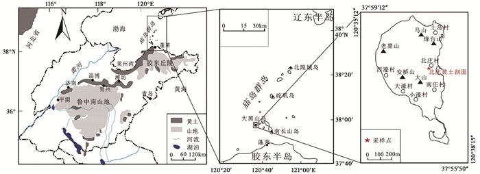
山东黄土主要包括两大分布区:鲁中山前区和渤海湾滨海与岛屿区[17](图 1)。滨海岛屿区黄土主要指庙岛群岛黄土,前人研究推测该区曾大量接收冰期时渤海和黄海出露的陆架沉积物[18, 19],因而与黄土高原等地的内陆黄土相比具有很大的特殊性,是沿海地区轨道尺度气候变化和海平面变化的重要记录,具有重要的研究价值。此外,对该区的研究目前都侧重于宏观描述以及区域性对比,缺乏高分辨率研究分析。光释光(Optically Stimulated Luminescence,简称OSL)测年是近年来逐渐发展起来并被广泛应用于沉积物如水成沉积物[20~23]、沙漠或绿洲[24~26]、黄土[27~31]等各个领域的测年手段;粒度作为沉积物最基本特征,对环境具有明确的指示意义[32~34],已有研究表明黄土的粒度组成与全球及区域性古环境演变密切相关[35~38];磁化率的波动变化可以显示全球气候变化的信息,磁化率曲线又能够与深海氧同位素曲线有很好的对比,因而可作为反应古气候环境变化的敏感指标,对地层划分也具有重要意义[39, 41]。因此,对黄土沉积特征进行系统、高分辨率的研究分析,能更好地揭示其所代表的气候环境意义。基于此,本文在前人研究的基础上,以山东庙岛群岛大黑山岛北庄黄土为研究对象,借助钻井资料和样品测试资料,进行OSL测年研究,并结合粒度和磁化率特征,提取其中的沉积环境信息,分析该剖面所指示的区域古气候环境演变过程。
|
图 1 山东庙岛群岛大黑山岛北庄黄土剖面位置图 Fig. 1 The sampling location of the Beizhuang loess section in Daheishan Island, Shandong |
研究区位于山东庙岛群岛最西端的大黑山岛(图 1),岛屿面积7.47km2,主要由震旦纪石英岩、玄武岩等构成,海岸多悬崖峭壁,海蚀地貌发育强,第四纪期间海平面变化引起的多级古海面遗迹较多。晚更新世末期,海平面下降,黄渤海出露成为大陆架,受偏北风盛行的原因,裸露的海底沉积物被搬运沉降在整个庙岛群岛地区,与同西北内陆而来的黄土混合在一起,使群岛上包括大黑岛在内的各个岛屿广泛发育黄土,形成了早期的马兰黄土[42]。该区现代气候属暖温带季风气候,降水年内分配不均,雨热同期,夏季盛行东南风,冬季以北风为主。
经过对大黑山岛及其周边地区详细的野外考察,本文选择位于大黑山岛北庄村南端顶部平整的山前黄土剖面(BZ:37°57′56.03″N,120°37′15.33″E;海拔26m)为研究对象。本研究采取钻孔取芯的方法采样,岩芯全长为16.1m,底部13.2m至13.5m间为一层砾石层。将岩芯纵向剖开,以2cm间隔对岩芯进行系统连续采样,共获得792个粒度样品;以4cm为间隔获得404个磁化率样品。同时,在钻孔北侧2m处人工挖掘一平行探坑剖面,通过粒度测试该剖面与岩芯结果几乎一致,相对误差小于3 %。因此,在探坑剖面50cm、100cm、150cm和200cm处采集了4个OSL年代样品。基于野外对剖面岩性、颜色以及地层接触关系的观察,并结合岩芯长度测量,北庄黄土剖面自上而下地层特征见表 1。
| 表 1 大黑山岛北庄黄土剖面地层特征 Table 1 Stratigraphic characteristics of the Beizhuang loess section in Daheishan Island |
粒度样品测试使用英国生产的Mastersizer 2000激光粒度仪,测试范围为0.2~2000μm,相对误差小于2 %。取0.3~0.4g自然风干样品至100ml的烧杯中,加入10ml浓度为10 %的双氧水(H2O2),将其放在电热板上加热至完全反应以去除有机质;再向烧杯中加入10ml浓度为10 %的盐酸(HCl)煮沸去除碳酸盐,待烧杯冷却后给烧杯注满蒸馏水,静置12小时后用橡胶管抽出上清液以去掉Ca2+、H+等絮凝性较强的离子;最后加入10ml浓度为10 %的分散剂六偏磷酸钠溶液((NaPO3)6),用超声波震荡7分钟后进行上机测量。样品的测试在山东省水土保持与环境保育重点实验室完成的。
2.2.2 磁化率测试磁化率样品测试使用英国Bartington公司生产的MS2磁化率仪。先将样品在35℃下烘干,然后用玛瑙研钵将样品磨成粉末状装进体积为8cm3的磁学专用盒中压实,称取塑料盒中样品的质量并计算其密度,再将样品移至MS2磁化率仪测量低频(0.47KHz)和高频(4.7KHz)容积磁化率。所有样品重复测量3次,然后取其平均值为最后测量结果。通过测得样品的容积磁化率和密度计算出低频质量磁化率(χhf)、高频质量磁化率(χlf)和频率磁化率(χfd),计算公式为:χfd=(χlf-χhf)/χlf×100 %。
2.2.3 光释光测试将采集的OSL样品在实验室进行前处理过程,在实验室内弱红光下,去除铁管顶和底可能曝光、污染的部分,保留中心部位样品供等效剂量测定。从中取出约20g测定含水量和饱和含水量,之后将样品烘干充分研磨直至全部通过63μm的筛子,供测定样品中U、Th和K含量。将中心样品筛出<300μm的粒组放在1000ml烧杯中,先后加30 %的双氧水和30 %的盐酸,分别除去样品中的有机质和碳酸盐类。待反应充分后,加氨水中和,然后用高纯水清洗至中性。将反应完的样品筛出<90μm的粒组,用静水沉降法分离出4~11μm的粒组,低温(40℃)烘干。再分别加入40 %的氟硅酸(H2SiF6)和10 %的盐酸以清除长石和氟化物,然后用高纯水清洗至中性,用仪器检验是否残留长石,若无则将样品低温(40℃)烘干,然后用丙酮制成悬浊液,并用移液管沉降在不锈钢片上并且低温(40℃)烘干,最后制成细颗粒测片待测。样品的测试在中国地震局地壳应力研究所地壳动力学重点实验室完成,采用简单多片再生法(SMAR),测试仪器为丹麦Risoe DA-20-C/D型热/光释光自动测量仪。
3 结果分析 3.1 OSL测年结果分析根据大黑山岛北庄黄土剖面OSL样品的等效剂量(De)值和环境剂量率(D)数据进行计算,得到样品的OSL年龄值如表 2所示。北庄黄土剖面上部0~2m处OSL年龄值介于26.23±4.92~47.04±6.14ka之间,从上至下地层年代逐渐变老。剖面0.5m处OSL年龄为26.23±4.92ka,处于晚更新世末期,由此推断北庄黄土剖面顶端全新世黄土已基本被侵蚀掉或者没有沉积。根据整个庙岛群岛区域对比,位于大黑山岛东南侧南长山岛上的仙境源(XJY)剖面[43](37°55′51.7″N,120°44′47.3″E;海拔46.7m,厚度5m)在深度0.8m、2.5m、3.9m处的OSL年代分别为12.6±1.0ka、19.2±1.1ka和56.9±2.6ka;庙岛上的MDS剖面[14](37°56′31.9″N,120°40′35.9″N;海拔17m,厚度6.5m)3.02m处的年代为55.84±1.02ka,这说明北庄黄土剖面上部年代序列基本可靠。根据平均沉积速率来看,北庄剖面上部平均沉积速率为7.2cm/ka,仙境源剖面为12.5cm/ka,沉积速率相近。同时,XJY剖面和MDS剖面底部年龄分别在86.5ka和115.2ka左右,均处于末次间冰期内。因此,通过相同区域黄土OSL年龄的对比,可以推断北庄黄土主要为末次间冰期以来堆积的黄土。
| 表 2 大黑山岛北庄黄土剖面样品OSL测年结果 Table 2 OSL dating results of the samples from the Beizhuang loess section in Daheishan Island |
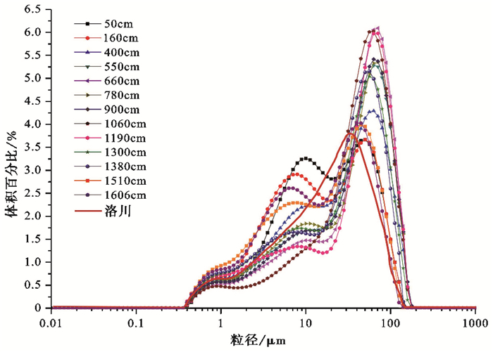
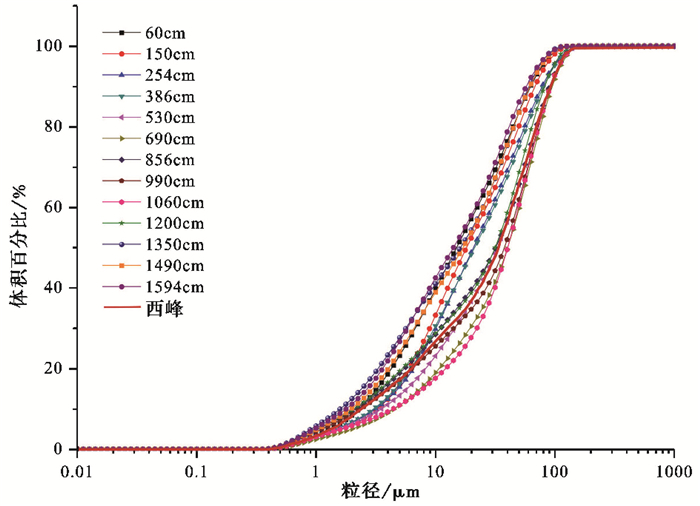
粒度频率分布曲线不仅反应样品总体特征,也能显示沉积物各粒级组分的含量变化,不同沉积物类型的粒度频率分布曲线各异,因此,沉积物的频率曲线特征可以作为判断沉积作用形式的重要手段[44~46]。图 2为北庄黄土剖面粒度频率分布曲线。由图 2可见,北庄黄土样品频率分布曲线主要呈三峰分布,突出的主峰主要集中40~80μm之间,次峰主要分布在6~15μm之间,最低峰小于2μm,表示该剖面风尘沉积作用明显;通过与洛川黄土[47]粒度频率曲线相对比,北庄黄土剖面曲线的最低峰与洛川黄土次峰相重合,但北庄黄土比洛川黄土在粉砂区多一个次峰,而最高峰比洛川黄土右移,说明北庄黄土颗粒较洛川黄土粗,同时表明两个地区的黄土在物质来源和形成环境方面还存在着明显差异。但是,北庄黄土粒度频率曲线中的次峰所代表的意义是否与该区物源及沉积环境具有密切关系,还有待于我们后期对曲线进行峰的分离工作并结合该区特殊的地理位置做更深入的探究。在粒度概率累积曲线上(图 3),北庄黄土剖面曲线为只有一个拐点的平滑曲线,拐点主要分布在10μm附近,小于拐点的粒度是挟持粒组和次生粒组,大于拐点的部分主要以悬浮粒组为主[48],这与西峰黄土[49]典型风尘堆积物的特征相似,初步表明北庄黄土堆积具有典型风成沉积特征。
|
图 2 大黑山岛北庄黄土剖面粒度频率分布曲线图 Fig. 2 The grain size frequency distribution curves of the Beizhuang loess section in Daheishan Island |
|
图 3 大黑山岛北庄黄土剖面粒度概率累积曲线图 Fig. 3 Probability cumulative curves of the Beizhuang loess section in Daheishan Island |
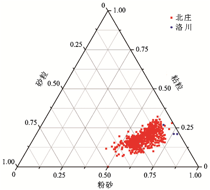
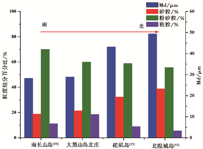
粒度组成是表述沉积物特征的重要指标之一,能够反映沉积物形成的动力机制、物质来源和沉积环境等信息[50~53]。测试结果如表 3及图 4所示,北庄黄土砂粒(>63μm)含量变化范围为4.07 % ~45.13 %,平均含量为21.4 %;粉砂粒(5~63μm)含量变化范围为43.25 % ~73.64 %,平均含量为60.1 %;粘粒(<5μm)含量变化范围为7.75 % ~32.08 %,平均含量为18.5 %。粉砂级组分为风成沉积的“基本粒组”,是典型风成黄土的主要组成部分[10],北庄黄土粉砂粒级含量最高,表明其具有风成沉积的典型特征。根据表 3和图 4可以看出,一方面北庄黄土与洛川典型风成黄土的粒度组成非常相似,同时与山东地区其他黄土剖面[43, 54~56]相比性状存在一致性,均以粉砂为主且含量>50 %,而<50μm的粉砂组分占绝对优势是风成堆积的典型特征[53],这很好的指示了风成成因;另一方面北庄黄土砂粒含量较洛川以及山东内陆章丘埠西黄土明显要多(表 3),粒度整体偏粗,这与前人研究的中国黄土分布规律[10]不一致。这说明本区黄土物源及沉积环境与洛川黄土相比有显著差异。此外,由图 5还可以看出由南向北分布的南长山岛剖面、大黑山岛北庄剖面、砣矶岛剖面和北隍城岛剖面,粒度组成中的砂粒含量逐渐增多,这说明该地区黄土可能存在着从北方向过来的近源物质。
| 表 3 不同地区黄土剖面粒度对比 Table 3 Comparison of the loess grain size in different areas |
|
图 4 大黑山岛北庄黄土剖面粒度组成三角图 Fig. 4 The grain size ternary diagrams of the Beizhuang loess section in Daheishan Island |
|
图 5 大黑山岛北庄黄土剖面与庙岛群岛其他剖面粒度对比图 Fig. 5 Comparison of the profiles among the different areas in the Miaodao Islands |
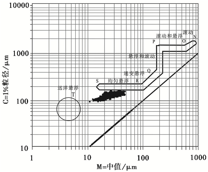
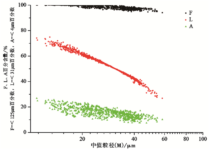
沉积物的粒度象可以反映沉积物的沉积过程以及形成环境等等[37]。粒度象的C-M图(C为累积曲线上1 %处所对应的粒径,M为中值粒径)已被广泛应用于风成沉积的研究中[55]。由C-M图可知北庄黄土剖面C介于100~200μm之间,M在10~60μm之间变化,在C-M图投影比较集中(图 6)。A-M、L-M和F-M对沉积物的组分变化有很好的指示。从图 7中可以看出,小于4μm的组分整体上所占比例很小,而小于31μm组分含量也<50 %,说明细粒物质不占优势,沉积物沉积动力比较大;整个剖面样品沉积物颗粒几乎全部小于125μm;M的增加主要由31~125μm的部分控制,即随着M值的增大,4~31μm百分含量逐渐减少,31~125μm的含量急剧增大,而F( < 125μm)有一定程度的减小。整体上沉积物变化组分主要是4~125μm,变化具有一定的连续性。
|
图 6 大黑山岛北庄黄土剖面C-M图 Fig. 6 The C-M diagrams of the Beizhuang loess section in Daheishan Island |
|
图 7 大黑山岛北庄黄土剖面A-M、F-M和L-M图 Fig. 7 The integrated A-M, F-M and L-M diagrams of the Beizhuang loess section in Daheishan Island |
通过沉积物的粒度参数可以推测沉积物的形成环境及搬运动力[57, 58]。平均粒径(Mz)表示粒度分布的集中趋势,标准偏差(σI)表示沉积物的均一程度,反映沉积分选的好坏,偏度(SkI)反映沉积物粒度频率分布的对称性,峰态(KG)主要表示沉积物粒度频率分布曲线的峰凸程度。通过福克和沃德样品统计值图解法[59]的计算公式计算出北庄黄土粒度特征参数如表 4所示,北庄黄土Mz介于4.68~6.60Φ范围内,平均值为5.64Φ;σI变化范围为1.51~2.23,平均值为1.97;SkI变化范围为0.08~0.37,平均值为0.21;KG变化范围为0.79~1.57,平均值为0.93,综合分析上述所有指标,北庄黄土与洛川黄土[10]粒度参数特征相近,是典型风尘物质堆积粒级范围,这与上文所述一致。
| 表 4 大黑山岛北庄黄土与不同地区黄土粒度参数的对比 Table 4 Composition of grain sizes measured between the Beizhuang loess in Daheishan Island and different area loess elsewhere |
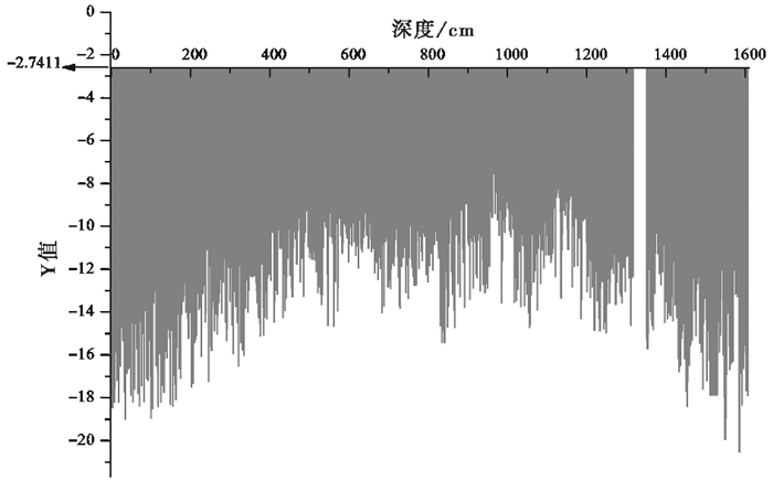
萨胡判别公式是前人根据大量的统计数据,综合分析得出的一系列判别沉积环境及沉积作用的判别函数,目前在判断沉积物成因方面得到很好的应用[57, 60]。本文应用风和海滩之间的判别公式进行分析:Y=-3.5688Mz+3.7016σI2-2.0766SkI+3.1135KG,若Y<-2.7411,说明样品形成于风成沉积环境;若Y>-2.7411则沉积物属海滩的,将所计算的粒度参数(Mz、σI、SkI和KG)带入萨胡判别公式中,结果如图 8所示:该剖面黄土沉积物Y值变化范围为-20.55~-6.12,均小于-2.7411,结合沉积物粒度组成和粒度频率分布曲线特征说明该黄土剖面为风成堆积物。
|
图 8 大黑山岛北庄黄土剖面沉积物判别函数值 Fig. 8 Y value of grain size distribution of the Beizhunag loess section in Daheishan Island |
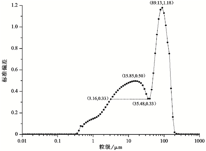
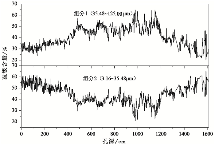
由于沉积环境和物质来源的多样性和复杂性,沉积物的全岩粒度特征只能反映其沉积动力、物质来源以及古环境演变的平均水平。因此,提取环境敏感粒度组分对研究沉积物的沉积环境具有重要的意义[61~65]。本文采用粒级-标准偏差法提取该剖面沉积物的环境敏感组分,其理论依据是样品粒度的不同粒级对应的标准偏差数值的大小不同,大的标准偏差值反映了样品的粒度含量在某一粒径范围内差异较大,小的标准偏差值则反映了粒度含量在某一粒径范围内差异较小,标准偏差值大的对应的粒级即为沉积环境敏感组分[64]。图 9显示了利用粒级-标准偏差法得出的北庄剖面钻孔岩芯的2个粒度组分,2个明显的标准偏差峰值分别为89.13μm和15.85μm。由北庄黄土粒度象图分析结果可知<125μm的组分平均含量达98 % (图 7),因此,可以只考虑<125μm以下的粒度组分来反应环境变化。两个主要的粒度组分可提取为组分1粗粒径(35.48~125.00μm)含量和组分2细粒径(3.16~35.48μm)含量,据此计算两个粒度组分的粒级含量。由图 10可以看出,两个组分的粒级含量有明显的波动变化,几乎呈相反的变化趋势。
|
图 9 大黑山岛北庄黄土剖面的粒级-标准偏差曲线图 Fig. 9 The grade-standard deviation curve of the Beizhuang loess section in Daheishan Island |
|
图 10 北庄黄土2个环境敏感粒度组分的粒级含量变化 Fig. 10 Variations in content of two main populations of the Beizhuang loess in Daheishan Island |
孙东怀等[66]认为粒度分布中峰度较高组分代表了冬季风盛行季节近距离低空搬运的粉尘物质,其粒度指示了东亚冬季风近地面环流强度,它在黄土中的含量能够反映冬季风粉尘的沉积通量。
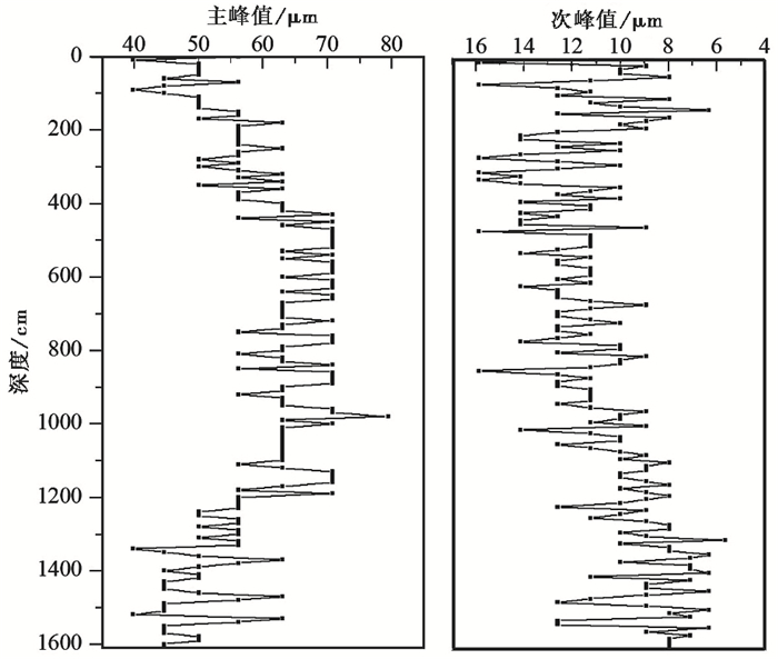
图 11为通过excel表格数据统计获得的北庄黄土岩芯粒度频率曲线主次峰值与深度关系曲线图,由图 11中可以看出整个岩芯自下而上主次峰值粒度变化具有一致性,均由细变粗再由粗变细,这与中值粒径(Md)变化趋势相吻合。且曲线峰谷波动旋回比价明显,呈“两峰一谷”的变化,这说明该剖面在堆积过程中经历了冷暖旋回的波动。
|
图 11 大黑山岛北庄黄土剖面粒度频率曲线峰值与深度关系曲线图 Fig. 11 The relationship between peak value and depth of the Beizhuang loess section in Daheishan Island |
由粒度频率分布曲线可知,主峰分布范围主要介于粉砂和砂粒范围之间,次峰居于粉砂范围内,但相比主峰其又位于粉砂范围内的细粒端,这与前人的研究次峰顶位于粘粒组且是易变动的次生粒组又不相符合[67],这说明该处的气候环境又具有区域性特征。通过主次峰值的变化趋势可以看出整个黄土沉积过程搬运动力发生了阶段性的显著变化。
3.3 磁化率特征分析磁化率是反映物质被磁化难易程度的一个物理量[68]。磁化率在中国黄土-古土壤序列研究中得到了广泛的应用,前人研究结果表明,黄土-古土壤中的磁化率值存在着差异,磁化率的高低与气候的暖湿-冷干相对应,并且与成壤作用有关[69~71]。因此黄土中的磁化率可以作为夏季风的替代性指标,并与深海沉积氧同位素记录具有较好的对比性。
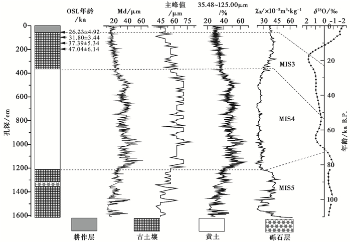
沉积物磁化率包括低频质量磁化率(χlf)、高频质量磁化率(χhf)和频率磁化率(χfd)。质量磁化率反映样品中磁性矿物含量的多少,通常与样品中含有的磁性矿物种类、粒度大小及含量多少有直接关系,通常作为估量样品总体磁性强弱的代表值。频率磁化率反映样品中超顺磁性的亚铁磁矿物超细晶粒(粒径<0.03μm)的存在与否及其含量变化[72, 73],因此可通过频率磁化率的值来反映样品颗粒大小的变化。总体来看,北庄村黄土剖面低频磁化率的变化范围为21.30×10⁻⁸~86.35×10⁻⁸ m3/kg,平均值为31.53×10-8 m3/kg;高频磁化率的变化范围为19.90×10-8~78.42×10-8m3/kg,平均值为29.86×10-8 m3/kg,高频与低频质量磁化率的变化基本相当。频率磁化率变化范围为0.61 % ~10.16 %,平均值为4.88 %。将北庄黄土质量磁化率(21.30×10⁻⁸~86.35×10⁻⁸ m3/kg)与洛川典型风成黄土(30×10-8~250×10-8m3/kg)[10]相对比得出,北庄黄土磁化率值很低(图 12)。而磁化率值的高低又受沉积物的粒度、物源等因素影响[74],通过磁化率对比结果可知,两地区黄土粒度大小具有差异性,这在上文中的粒度测试已经证明,同时也指示了两地区黄土物源的不同。如图 12所示,剖面磁化率曲线峰谷波动与中值粒径(Md)曲线所反映的峰值与谷值基本相吻合。峰值对应着古土壤层,代表温暖湿润的成壤时期,谷值对应着黄土层,代表干冷的黄土堆积时期,这为剖面的地层划分提供了显著依据。
|
图 12 大黑山岛北庄黄土剖面沉积记录与深海氧同位素对比 Fig. 12 Comparison of records between the Beizhuang loess section in Daheishan Island and SPECMAP |
根据刘东生等[75]提出的以氧同位素阶段(即MIS)为参照系统划分和对比的中国第四纪地层表,结合粒度、磁化率特征和光释光测年(OSL)结果,将北庄村黄土剖面堆积分为3期,与SPECMAP时间表基本一致[76, 77],如图 12所示。
剖面顶部至380cm为堆积的第一阶段,0~50cm为现代耕作层,含有较多的植被根系,受后期人为影响较大。根据OSL测年结果,该剖面缺失全新世及L1上层黄土堆积,不予讨论。50~380cm之间,剖面粒度组分以粉砂为主,平均含量为64.22 %,粘粒含量平均值为20.68 %,砂粒含量平均值为15.10 %,就整个剖面而言,该层段粒径组分分布比较均匀。通过粒度中值粒径(Md)、粗组分敏感粒级(35.48~125.00μm)以及主峰值(Mode)可以看出该层段黄土粒径整体偏细,钙质结核较丰富。低频磁化率(χlf)平均值为37.59×10⁻⁸m3/kg,高频磁化率(χhf)平均值是34.89×10-8m3/kg,均为整个剖面中最高值阶段,表明气候温暖湿润,推测应为古土壤层。在该层段内50cm处测得年代为26.23±4.92ka,且根据赖忠平[78]划分的黄土氧同位素阶段3/2界限,该层古土壤为马兰黄土中部的古土壤层,与MIS 3相对应。此阶段应为末次冰期内的暖期,冬季风较弱,这期间黄渤海发生两次主要的海进事件,即沧州海进和献县海进[79],黄渤海海平面上升,大陆架被淹没,使得此处由东北风带来的近距离物质来源减少,远源物质含量相对增加,但依然以近源为主。
剖面380~1220cm为堆积的第二阶段,为黄土层,剖面平均粒径增大,粒度变粗,粉砂平均含量为57.22 %,粘粒平均含量为16.01 %,砂粒平均含量为26.76 %,是整个剖面砂粒含量最多的层段,对应的磁化率也是整个剖面中最低的阶段,χlf和χhf平均值分别为25.80×10⁻⁸m3/kg和24.98×10-8m3/kg。该时期应处于末次冰期的玉木冰期阶段,气候寒冷,主要盛行冬季风,海水退缩,海平面下降,黄渤海大陆架裸露,形成陆地,为该处提供了充足的物源[80];风搬运能力加强,不仅有高空气流从西部带来的粉砂颗粒,盛行的北风及东北风带来的大量的粗颗粒组分也在该处沉积,使得该层段黄土颗粒为最粗,剖面黄土应为马兰黄土中的下层黄土,与MIS 4相对应。
剖面1220~1610cm为古土壤层,中间1320~1350cm处夹有一层砾石层。该层段仍以粉砂含量为主,平均值为62.93 %,但粘粒含量增加,平均值为23.18 %,为在整个剖面粘粒含量最多的层位,砂粒含量最少为13.89 %,χlf和χhf值也较高,平均值为37.16×10⁻⁸m3/kg和34.74×10-8m3/kg。该时期应为晚更新世早期处于末次间冰期,气候温暖湿润,淋溶作用和化学风化作用较强,成壤作用加强,形成古土壤。同时,黄渤海海平面较高,粗颗粒的近源物质减少[80],导致该层中粗颗粒含量为整个剖面最低值。同时在此阶段气候暖湿的大背景条件下,气候还经历了较小的冷暖波动,剖面黄土应为S1层古土壤,与MIS 5相对应。
5 结论通过上述分析,初步得出如下结论:
(1) 根据OSL测年结果分析,北庄黄土剖面顶端全新世黄土被侵蚀掉或者没有沉积。根据北庄黄土剖面上部OSL年代框架与区域内其他剖面进行年代对比,可推断北庄黄土主要为末次间冰期以来堆积的黄土。
(2) 通过对北庄黄土剖面野外观测以及对钻孔岩芯的粒度特征分析,并与黄土高原典型黄土以及山东其他地区黄土相对比得出,北庄黄土为典型风成沉积物,但又有其自身的特点。北庄黄土粒度频率曲线为三峰分布,黄土砂粒含量比其他地区含量高,与同区域其他岛屿上的黄土相比,具有从南往北砂粒含量增多、粒度变粗的趋势,这说明该地区除了接受从西北内陆搬运来的远源粉尘外,还应接受了大量从北方向吹来的近源物质。因此,该区黄土的沉积特征可以指示晚第四纪以来我国东部季风的变化。
(3) 北庄村黄土剖面低频磁化率与高频磁化率变化趋势基本相当,与洛川典型黄土磁化率对比具有差异,这说明两地区黄土的粒度与物源不同。同时,剖面磁化率曲线峰谷波动与中值粒径(Md)曲线所反映的峰值与谷值基本相吻合,这为剖面的地层划分也提供了显著依据。
(4) 结合OSL测年,将北庄黄土粒度和磁化率变化趋势与深海氧同位素阶段相对应,该剖面主要分为3个阶段,剖面上部50~380cm为古土壤层,该阶段与MIS 3相对应,为马兰黄土中部的古土壤层,气候比较湿暖;剖面中部380~1220cm为黄土层,该阶段与MIS 4相对应,为马兰黄土下部的黄土层,气候冷干;剖面下部1220~1610cm为古土壤层,该阶段与MIS 5相对应,应为S1层古土壤,此阶段气候暖湿,期间气候还经历了较小的冷暖波动。
致谢 感谢青海晶诚地矿有限责任公司对钻探取芯工作提供的帮助;感谢审稿专家提出的建设性修改意见,感谢杨美芳编辑提出的宝贵意见和提供的耐心帮助。
| 1 |
Jin C S, Liu Q S. Remagnetization mechanism and a new age model for L9 in Chinese loess. Physics of the Earth and Planetary Interiors, 2011, 187(3): 261-275. |
| 2 |
Qiao Y S, Qi L, Liu Z X et al. Intensification of aridity in the eastern margin of the Tibetan Plateau since 300ka BP inferred from loess-soil sequences, western Sichuan Province, Southwest China. Palaeogeography, Palaeoclimatology, Palaeoecology, 2014, 414(414): 192-199. |
| 3 |
Zhao G, Liu X, Chen Q et al. Paleoclimatic evolution of Holocene loess and discussion of the sensitivity of magnetic susceptibility and median diameter. Quaternary International, 2013, 296(3): 160-167. |
| 4 |
周子博, 刘秀铭, 吕镔等. 印度德干高原Panchgini地区黄土性质初探. 第四纪研究, 2016, 36(2): 354-366. Zhou Zibo, Liu Xiuming, Lü Bin et al. A study on the Panchgini loess of Deccan Plateau, India. Quaternary Sciences, 2016, 36(2): 354-366. |
| 5 |
Sun Z X, Wang Q B, Han C L et al. Clay mineralogical characteristics and the palaeoclimatic significance of a Holocene to Late Middle Pleistocene loess-palaeosol sequence from Chaoyang, China. Earth and Environmental Science Transactions of The Royal Society of Edinburgh, 2016, 106(3): 1-13. |
| 6 |
刘东生, 安芷生, 袁宝印. 中国的黄土与风尘堆积. 第四纪研究, 1985(1): 113-125. Liu Tungsheng, An Zhisheng, Yuan Baoyin. Eolian process and dust mantle(loess)in China. Quaternary Sciences, 1985(1): 113-125. |
| 7 |
赵艳雷, 庞奖励, 黄春长等. 郧县前坊村剖面黄土-古土壤序列风化成壤及古气候研究. 沉积学报, 2014, 32(5): 840-845. Zhao Yanlei, Pang Jiangli, Huang Chunchang et al. Study on loess-weathering paleosol sequence and paleoclimate evolution in QFC profile in Yunxian, China. Acta Sendimentologica Sinica, 2014, 32(5): 840-845. |
| 8 |
张文翔, 史正涛, 刘勇等. 新疆伊犁盆地黄土古气候记录与Heinrich事件对比分析. 冰川冻土, 2015, 37(4): 973-979. Zhang Wenxiang, Shi Zhengtao, Liu Yong et al. Climatic record in the loess-paleosol sediment in the Ili Basin and comparative analysis with the Heinrich events. Journal of Glaciology and Geocryology, 2015, 37(4): 973-979. |
| 9 |
吴海锋, 鹿化煜, 张瀚之等. 雅鲁藏布江中游12ka BP前后的黄土堆积及其气候意义. 中国沙漠, 2016, 36(3): 616-622. Wu Haifeng, Lu Huayu, Zhang Hanzhi et al. A climate event at about 12ka BP revealed by loess deposit in middle reaches of Yarlung Zangbo River, Southern Tibetan Plateau, China. Journal of Desert Research, 2016, 36(3): 616-622. DOI:10.7522/j.issn.1000-694X.2015.00172 |
| 10 |
刘东生等. 黄土与环境. 北京: 科学出版社, 1985, 1-408. Liu Tungsheng et al. Loess and Environment. Beijing: Science Press, 1985, 1-408. |
| 11 |
周鑫, 郭正堂, 彭淑贞等. 西峰剖面午城黄土古风化强度变化与早更新世季风环境演化. 第四纪研究, 2007, 27(4): 645-650. Zhou Xin, Guo Zhengtang, Peng Shuzhen et al. Variations of paleo-weathering intensity of the Wucheng loess formation at Xifeng and the implications on environmental changes. Quaternary Sciences, 2007, 27(4): 645-650. |
| 12 |
Jiang W Y, Yang X X, Cheng Y F. Spatial patterns of vegetation and climate on the Chinese Loess Plateau since the Last Glacial Maximum. Quaternary International, 2015, 372(7): 52-60. |
| 13 |
Stevens T, Buylaert J P, Lu H Y et al. Mass accumulation rate and monsoon records from Xifeng, Chinese Loess Plateau, based on a luminescence age model. Journal of Quaternary Sciences, 2016, 31(4): 391-405. DOI:10.1002/jqs.v31.4 |
| 14 |
Du S H, Li B S, Li Z W et al. Rapid East Asian monsoon change during the Last Interglacial in the Bohai Sea Coastal Zone, China. Journal of Sedimentary Research, 2014, 84(1): 88-96. |
| 15 |
Peng S Z, Hao Q Z, Wang L et al. Geochemical and grain-size evidence for the provenance of loess deposits in the central Shandong Mountains region, Northern China. Quaternary Research, 2016, 85(2): 290-298. DOI:10.1016/j.yqres.2016.01.005 |
| 16 |
徐树建, 倪志超, 丁新潮. 山东平阴黄土剖面常量元素地球化学特征. 矿物岩石地球化学通报, 2016, 35(2): 353-359. Xu Shujian, Ni Zhichao, Ding Xinchao. Geochemical characteristics of major elements of the Pingyin loess in Shandong Province. Bulletin of Mineralogy, Petrology and Geochemistry, 2016, 35(2): 353-359. |
| 17 |
张祖陆, 辛良杰, 聂晓红. 山东地区黄土研究综述. 地理科学, 2004, 24(6): 746-752. Zhang Zulu, Yin Liangjie, Nie Xiaohong. A summary of loessial researches in Shandong. Scientia Geographica Sinica, 2004, 24(6): 746-752. |
| 18 |
曹家欣, 李培英, 石宁. 山东庙岛群岛的黄土. 中国科学(B辑), 1987, 17(10): 1116-1123. Cao Jiaxin, Li Peiying, Shi Ning. Study on the loess of Miaodao Islands in Shandong Province. Science in China (Series B), 1987, 17(10): 1116-1123. |
| 19 |
于洪军. 中国东部陆架黄土成因的新探索. 第四纪研究, 1999, 7(4): 367-372. Yu Hongjun. A new exploration on the origin of loess in the shelf area of the Eastern China seas. Quaternary Sciences, 1999, 7(4): 367-372. |
| 20 |
Olszak J, Kukulak J, Alexanderson H. Revision of river terrace geochronology in the Orawa-Nowy Targ Depression, South Poland:Insights from OSL dating. Proceedings of the Geologists Association, 2016, 127(5): 595-605. DOI:10.1016/j.pgeola.2016.09.004 |
| 21 |
Zhang J, Tsukamoto S, Jia Y et al. Lake level reconstruction of Huangqihai Lake in Northern China since MIS 3 based on pulsed optically stimulated luminescence dating. Journal of Quaternary Sciences, 2016, 31(3): 225-238. DOI:10.1002/jqs.v31.3 |
| 22 |
凌光久, 贾玉连, 马春梅等. 内蒙古黄旗海中晚全新世(3580-1630call.a B.P.)气候环境记录. 第四纪研究, 2016, 36(2): 257-267. Ling Guangjiu, Jia Yulian, Ma Chunmei et al. Mid-Late Holocene(3580-1630cal.a B.P.)climate and environment records from Huangqihai Lake in Inner Mongolia. Quaternary Sciences, 2016, 36(2): 257-267. |
| 23 |
隆浩, 张静然. 晚第四纪湖泊演化光释光测年. 第四纪研究, 2016, 36(5): 1191-1203. Long Hao, Zhang Jingran. Luminescence dating of Late Quaternary lake-levels in Northern China. Quaternary Sciences, 2016, 36(5): 1191-1203. |
| 24 |
于禄鹏, 赖忠平, 安萍. 柴达木盆地中部与西南部古沙丘的光释光年代学研究. 中国沙漠, 2013, 33(2): 453-462. Yu Lupeng, Lai Zhongping, An Ping. OSL chronology of paleodunes in the middle and southwestern Qaidam Basin, China. Journal of Desert Research, 2013, 33(2): 453-462. DOI:10.7522/j.issn.1000-694X.2013.00062 |
| 25 |
耿建伟, 赵晖, 王兴繁等. 历史时期额济纳盆地水系与绿洲演变过程及其机制研究. 第四纪研究, 2016, 36(5): 1204-1215. Geng Jianwei, Zhao Hui, Wang Xingfan et al. Oasis and drainage network evolution processes and mechanisms of Ejina Basin during historical period. Quaternary Sciences, 2016, 36(5): 1204-1215. |
| 26 |
He Z, Zhou J, Lai Z P et al. Quartz OSL dating of sand dunes of Late Pleistocene in the Mu Us Desert in Northern China. Quaternary Geochronology, 2010, 5(2-3): 102-106. DOI:10.1016/j.quageo.2009.02.011 |
| 27 |
王恒松, 黄春长, 周亚利等. 渭河中游全新世黄土剖面光释光测年及记录的古洪水事件. 地质学报, 2012, 86(6): 994-1004. Wang Hengsong, Huang Chunchang, Zhou Yali et al. OSL dating of Holocene loess-paleosol profiles in the middle reaches of Weihe River and palaeoflood events. Acta Geologica Sinica, 2012, 86(6): 994-1004. |
| 28 |
张玉柱, 黄春长, 庞奖励等. 黄河上游官亭盆地喇家遗址地层光释光测年研究. 地理学报, 2013, 68(5): 626-639. Zhang Yuzhu, Huang Chunchang, Pang Jiangli et al. OSL dating of the sediment stratigraphy of the Lajia Ruins in the Guanting Basin in the upper Yellow River basin. Acta Geographica Sinica, 2013, 68(5): 626-639. DOI:10.11821/xb201305005 |
| 29 |
杜建军, 黎敦朋, 马寅生等. 18.7万年前的高速远程古滑坡:来自陕西华县莲花寺滑坡体上覆黄土光释光(OSL)测年的证据. 第四纪研究, 2013, 33(5): 1005-1015. Du Jianjun, Li Dunpeng, Ma Yinsheng et al. The high-speed and long-distance ancient landslides before 187ka:The evidence from the OSL dating of the loess overlying the landslides body of Lianhuasi landslides in Huaxian, Shaanxi Province, China. Quaternary Sciences, 2013, 33(5): 1005-1015. |
| 30 |
Wang S J, Lu H Y, Zhang H Y et al. Newly discovered Palaeolithic artefacts from loess deposits and their ages in Lantian, Central China. Science Bulletin, 2014, 59(7): 651-661. DOI:10.1007/s11434-013-0105-5 |
| 31 |
葛本伟, 刘安娜. 天山北麓黄土剖面的光释光测年分析. 干旱区研究, 2016, 33(4): 869-876. Ge Benwei, Liu Anna. Optical dating of aeolian loess in northern slope of the Tianshan Mountains, China. Arid Zone Research, 2016, 33(4): 869-876. |
| 32 |
滕晓华, 张志高, 韩文霞等. 塔里木盆地南缘黄土粒度特征及其环境意义. 沉积学报, 2015, 33(5): 941-950. Teng Xiaohua, Zhang Zhigao, Han Wenxia et al. Grain-size characteristics and its environmental significance of loess from southern Tarim Basin. Acta Sendimentologica Sinica, 2015, 33(5): 941-950. |
| 33 |
刘世昊, 丰爱平, 李培英等. 现代黄河三角洲地区晚更新世以来高分辨率沉积粒度特征及动力沉积环境演化. 第四纪研究, 2015, 35(2): 291-306. Liu Shihao, Feng Aiping, Li Peiying et al. High-resolution grain size distribution and evolution of the sediment-dynamic environment in the modern Yellow River delta since the Late Pleistocene. Quaternary Sciences, 2015, 35(2): 291-306. DOI:10.11928/j.issn.1001-7410.2015.02.05 |
| 34 |
苏志珠, 梁爱民, 马义娟等. 库姆塔格沙漠典型线性沙丘粒度特征. 中国沙漠, 2016, 36(4): 877-884. Su Zhizhu, Liang Aimin, Ma Yijuan et al. Grain-size charcterisitics of typical linear dunes in the Kumtagh Desert. Journal of Desert Research, 2016, 36(4): 877-884. DOI:10.7522/j.issn.1000-694X.2016.00092 |
| 35 |
Porter S C, An Z S. Correlation between climate events in the North Atlantic and China during the Last Glaciation. Nature, 1995, 375(6529): 305-308. DOI:10.1038/375305a0 |
| 36 |
鹿化煜, 安芷生. 黄土高原黄土粒度组成的古气候意义. 中国科学(D辑), 1998, 28(3): 278-283. Lu Huayu, An Zhisheng. Paleoclimatic significance of loess granularity composition in the Loess Plateau. Science in China (Series D), 1998, 28(3): 278-283. |
| 37 |
李超, 杨石岭, 李阳阳等. 河南卢氏盆地张家村组粒度特征与沉积环境研究. 第四纪研究, 2016, 36(6): 1428-1435. Li Chao, Yang Shiling, Li Yangyang et al. Grain size characteristics and sedimentary environment of the Zhangjiacun formation in the Lushi Basin, Henan Province. Quaternary Sciences, 2016, 36(6): 1428-1435. |
| 38 |
Ben-Israel M, Enzel Y, Amit R et al. Provenance of the various grain-size fractions in the Negev loess and potential changes in major dust sources to the Eastern Mediterranean. Quaternary Research, 2015, 83(1): 105-115. DOI:10.1016/j.yqres.2014.08.001 |
| 39 |
Heller F, Liu T S. Magnetostratigraphical dating of loess deposits in China. Nature, 1982, 300(5891): 431-433. DOI:10.1038/300431a0 |
| 40 |
王世朋, 李永祥, 付少英等. 南海北部陆坡GHE24L柱样沉积物磁性特征及其环境意义. 第四纪研究, 2014, 34(3): 516-527. Wang Shipeng, Li Yongxiang, Fu Shaoying et al. Environmental changes as recorded by mineral magnetic properties of sediments from the core CHE24L, South China Sea. Quaternary Sciences, 2014, 34(3): 516-527. |
| 41 |
李建星, 王建强, 岳乐平等. 阿尔金新近纪红粘土的古地磁年代及古气候记录. 第四纪研究, 2016, 36(5): 1103-1113. Li Jianxing, Wang Jianqiang, Yue Leping et al. Magnetostratigraphic chronology and paleoenvironmental records of Neogene red clay in Altun, Western China. Quaternary Sciences, 2016, 36(5): 1103-1113. |
| 42 |
赵松龄. 晚更新世末期中国陆架沙漠化及其衍生沉积的研究. 海洋与湖沼, 1991, 22(3): 285-293. Zhao Songling. China shelf sea desertization and its derived deposits during the last stage of Late Pleistocene. Oceanologia et Limnologia Sinica, 1991, 22(3): 285-293. |
| 43 |
Xu S J, Ding X C, Yu L P et al. Palaeoclimatic implications of aeolian sediments on the Miaodao Islands, Bohai Sea, East China, based on OSL dating and proxies. Aeolian Research, 2015, 19(Part B): 259-266. |
| 44 |
Sun D H, Su R X, Bloemendal J et al. Grain-size and accumulation rate records from Late Cenozoic aeolian sequences in Northern China:Implications for variations in the East Asian winter monsoon and westerly atmospheric circulation. Palaeogeography, Palaeoclimatology, Palaeoecology, 2008, 264(1-2): 39-53. DOI:10.1016/j.palaeo.2008.03.011 |
| 45 |
张晋, 李安春, 万世明等. 南海南部表层沉积物粒度分布特征及其影响因素. 海洋地质与第四纪地质, 2016, 36(2): 1-10. Zhang Jin, Li Anchun, Wan Shiming et al. Grain size distribution of surface sediments in the southern South China Sea and influencing factors. Marine Geology & Quaternary Geology, 2016, 36(2): 1-10. |
| 46 |
姜韬, 曾志刚, 南青云等. 全新世以来冲绳海槽北部S9孔粒度变化特征及其古气候响应. 第四纪研究, 2015, 35(2): 307-318. Jiang Tao, Zeng Zhigang, Nan Qingyun et al. The grain size characteristics of the core S9 sediments in the northern Okinawa Trough and their paleoclimate response since Holocene. Quaternary Sciences, 2015, 35(2): 307-318. DOI:10.11928/j.issn.1001-7410.2015.02.06 |
| 47 |
Song Y G, Chen X L, Qian L B et al. Distribution and composition of loess sediments in the Ili Basin, Central Asia. Quaternary International, 2014, 334(12): 61-73. |
| 48 |
Pye K. Aeolian Dust and Dust Deposits. London:Academic Press, 1987, 29-62. |
| 49 |
鹿化煜, 安芷生. 黄土高原红粘土与黄土古土壤粒度特征对比——红粘土风成成因的新证据. 沉积学报, 1999, 17(2): 226-232. Lu Huayu, An Zhisheng. Comparison of grain-size distribution of red clay and loess-paleosol deposits in Chinese Loess Plateau. Acta Sedimentologica Sinica, 1999, 17(2): 226-232. |
| 50 |
范佳伟, 肖举乐, 温锐林等. 达里湖沉积粒度组分-湖面状况定量模型. 第四纪研究, 2016, 36(3): 612-622. Fan Jiawei, Xiao Jule, Wen Ruilin et al. A model for the linkage between grain-size component in the Dali Lake sediments and lake level status. Quaternary Sciences, 2016, 36(3): 612-622. |
| 51 |
AU'G jvári G, Kok J F, Varga G et al. The physics of wind-blown loess:Implications for grain size proxy interpretations in Quaternary paleoclimate studies. Earth-Science Reviews, 2016, 154(1): 247-278. |
| 52 |
宗娴, 石学法, 葛晨东等. 日本海百年来沉积速率及粒度指示意义. 沉积学报, 2016, 34(3): 516-522. Zong Xian, Shi Xuefa, Ge Chendong et al. Sedimentation rate and implications of sediment grain size of Japan Sea during the last hundred years. Acta Sendimentologica Sinica, 2016, 34(3): 516-522. |
| 53 |
李传想, 宋友桂, 千琳勃等. 中亚昭苏黄土剖面粒度记录的末次冰期以来气候变化历史. 沉积学报, 2011, 29(6): 1170-1179. Li Chuanxiang, Song Yougui, Qian Linbo et al. History of climate change recorded by grain size at the Zhaosu loess section in the Central Asia since the Last Glacial period. Acta Sedimentologica Sinica, 2011, 29(6): 1170-1179. |
| 54 |
倪志超. 山东庙岛群岛黄土光释光年代及物源探讨. 济南:山东师范大学硕士论文, 2015, 1-58. Ni Zhichao. Optically Stimulated Luminescence Dating and the Provenance Analysis of Loess in Miaodao Islands, Shandong Province. Jinan:The Master's Thesis of Shandong Normal University, 2015, 1-58. |
| 55 |
丁新潮, 曹文, 徐树建等. 山东砣矶岛大口北黄土剖面的沉积特征及其古环境意义. 干旱区资源与环境, 2016, 30(10): 192-197. Ding Xinchao, Cao Wen, Xu Shujian et al. The sedimentary characteristics of Dakoubei loess profile in Tuoji Island and their palaeoenvironment significance. Journal of Arid Land Resources and Environment, 2016, 30(10): 192-197. |
| 56 |
徐树建, 丁新潮, 倪志超. 山东埠西黄土剖面沉积特征及古气候环境意义. 地理学报, 2014, 69(11): 1707-1717. Xu Shujian, Ding Xinchao, Ni Zhichao. The sedimentary characteristics of Buxi loess profile in Shandong Province and their paleoclimatic and palaeoenvironment significance. Acta Geographica Sinica, 2014, 69(11): 1707-1717. DOI:10.11821/dlxb201411011 |
| 57 |
Friedman G M, Sanders J E. Principle of Sedimentology. New York:John Wiley & Sons, 1978, 1-375. |
| 58 |
郭超, 马玉贞, 刘杰瑞等. 过去2000年来西藏羊卓雍错沉积物粒度记录的气候变化. 第四纪研究, 2016, 36(2): 405-419. Guo Chao, Ma Yuzhen, Liu Jierui et al. Climatic change recorded by grain-size in the past about 2000 years from Yamzhog Yumco Lake, Tibet. Quaternary Sciences, 2016, 36(2): 405-419. |
| 59 |
Folk R L, Ward W C. Brazos River bar:A study in the significance of grain size parameters. Journal of Sedimentary Research, 1957, 27(1): 3-26. DOI:10.1306/74D70646-2B21-11D7-8648000102C1865D |
| 60 |
Lu H Y, Vandenberghe J, An Z S. Aeolian origin and palaeoclimatic implications of the "red clay"(North China)as evidenced by grain-size distribution. Journal of Quaternary Science, 2001, 16(1): 89-97. DOI:10.1002/(ISSN)1099-1417 |
| 61 |
陈洪云, 孙有斌. 黄土高原风尘沉积的物质来源研究:回顾与展望. 第四纪研究, 2008, 28(5): 892-900. Chen Hongyun, Sun Youbin. Study on provenance of eolian dust deposits on the Chinese Loess Plateau:Retrospects and prospects. Quaternary Sciences, 2008, 28(5): 892-900. |
| 62 |
沈星, 褚忠信, 王玥铭等. 北黄海西部与南黄海中部泥质区岩芯敏感粒级及其环境意义. 沉积学报, 2015, 33(1): 124-133. Shen Xing, Chu Zhongxin, Wang Yueming et al. Sensitive grain size and its environmental significance of modern mud patches in southern and northern parts of the Yellow Sea. Acta Sendimentologica Sinica, 2015, 33(1): 124-133. |
| 63 |
田元, 范德江, 张喜林等. 东海内陆架沉积物敏感粒级构成及其地质意义. 海洋与湖沼, 2016, 47(2): 319-326. Tian Yuan, Fan Dejiang, Zhang Xilin et al. Sensitive grain size components and their geological implication in the inner shelf of the East China Sea. Oceanologia et Limnologia Sinica, 2016, 47(2): 319-326. |
| 64 |
高星华, 李广雪, 张海啟等. 近60年来南黄海沉积物高分辨率敏感粒级对东亚冬季风的响应. 海洋地质前沿, 2016, 32(8): 1-9. Gao Xinghua, Li Guangxue, Zhang Haiqi et al. Response of sensitive grain-size to East Asian winter monsoon for past 60 years in the mud area of western South Yellow Sea. Marine Geology Frontiers, 2016, 32(8): 1-9. |
| 65 |
涂路遥, 周鑫, 刘毅等. 近海泥质沉积物敏感粒径作为冬季风强度指标的再研究:与器测数据的对比. 第四纪研究, 2015, 35(6): 1393-1401. Tu Luyao, Zhou Xin, Liu Yi et al. Re-analysis of sensitive grain size of coastal muddy sediments as proxy of winter monsoon strength:Comparison with instrumental data. Quaternary Sciences, 2015, 35(6): 1393-1401. |
| 66 |
孙东怀, 鹿化煜, David Rea等. 中国黄土粒度的双峰分布及其古气候意义. 沉积学报, 2000, 18(3): 327-335. Sun Donghuai, Lu Huayu, David Rea et al. Bimode grain-size distribution of Chinese loess and its paleoclimate implication. Acta Sedimentologica Sinica, 2000, 18(3): 327-335. |
| 67 |
张祖陆, 辛良杰, 姜鲁光等. 山东济南张夏黄土堆积及成因分析. 古地理学报, 2005, 7(1): 98-106. Zhang Zulu, Xin Liangjie, Jiang Luguang et al. Sedimentary characteristics and genetic analysis of Zhangxia loess in Jinan, Shandong Province. Journal of Palaeogeography, 2005, 7(1): 98-106. |
| 68 |
Thompson R, Oldfield F. Environmental Magnetism. London:Allen & Unwin, 1986, 1-486. |
| 69 |
Kukla G, An Z S. Loess stratigraphy in Central China. Palaeogeography, Palaeoclimatology, Palaeoecology, 1989, 72(1-2): 203-225. |
| 70 |
吉茹, 胡忠行, 张卫国等. 浙江金衢盆地界首红土剖面磁性特征及环境意义. 第四纪研究, 2015, 35(4): 1020-1029. Ji Ru, Hu Zhongxing, Zhang Weiguo et al. Magnetic properties of the Jieshou red clay sequence in the Jinhua-Quzhou Basin, Southeastern China and its paleoenvironmental implications. Quaternary Sciences, 2015, 35(4): 1020-1029. |
| 71 |
Dong Y, Wu N, Li F et al. Time-transgressive nature of the magnetic susceptibility record across the Chinese Loess Plateau at the Pleistocene/Holocene transition. PLoS ONE, 2015, 10(7): e0133541.. DOI:10.1371/journal.pone.0133541 |
| 72 |
邱思静, 陈一凡, 王振等. 天山北麓乌鲁木齐河阶地晚更新世黄土磁学特征及古气候意义. 第四纪研究, 2016, 36(5): 1319-1330. Qiu Sijing, Chen Yifan, Wang Zhen et al. Rock magnethic properties and paleoclimatic implications of Late Pleistocene loess in the range front of the Vrümqi River, Xinjiang, NW China. Quaternary Sciences, 2016, 36(5): 1319-1330. |
| 73 |
侯顺民, 刘秀铭, 吕镔等. 土耳其Nallihan黄土-古土壤岩石磁学特征及其环境意义. 第四纪研究, 2015, 35(4): 1006-1019. Hou Shunmin, Liu Xiuming, Lü Bin et al. Rock magnetic properties of loess in Nallihan, Turkey and its environmental significances. Quaternary Sciences, 2015, 35(4): 1006-1019. |
| 74 |
王建, 刘泽纯, 姜文英等. 磁化率与粒度、矿物的关系及其古环境意义. 地理学报, 1996, 51(2): 155-163. Wang Jian, Liu Zechun, Jiang Wenying et al. A relationship between susceptibility and grain-size and minerals, and their paleo-environmental implications. Acta Geographica Sinica, 1996, 51(2): 155-163. |
| 75 |
刘东生, 施雅风, 王汝建等. 以气候变化为标志的中国第四纪地层对比表. 第四纪研究, 2000, 20(2): 108-128. Liu Tungsheng, Shi Yafeng, Wang Rujian et al. Table of Chinese Quaternary stratigraphic correlation remarked with climate change. Quaternary Sciences, 2000, 20(2): 108-128. |
| 76 |
安芷生, Kukla G, 刘东生. 洛川黄土地层学. 第四纪研究, 1989(2): 155-168. An Zhisheng, Kukla G, Liu Tungsheng. Loess stratigraphy in Luochuan of China. Quaternary Sciences, 1989(2): 155-168. |
| 77 |
康建成, 温家洪. 15万年以来极地冰芯、黄土、深海沉积的对比研究与全球变化. 极地研究, 1997, 9(2): 134-144. Kang Jiancheng, Wen Jiahong. Comprehensive records of global change from polar ice cores, loess profiles and deep sea cores for last 150000 years. Chinese Journal of Polar Research, 1997, 9(2): 134-144. |
| 78 |
赖忠平. 基于光释光测年的中国黄土中氧同位素阶段2/1和3/2界限位置及年代的确定. 第四纪研究, 2008, 28(5): 883-891. Lai Zhongping. Locating and dating the boundaries of MIS 2/1 and 3/2 in Chinese loess using luminescence techniques. Quaternary Sciences, 2008, 28(5): 883-891. |
| 79 |
中国科学院海洋研究所, 海洋地质研究室. 渤海地质. 科学出版社, 1985. 1~232 Department of Marine Geology, Institute of Oceanology, Chinese Academy of Sciences. Geology of the Bohai Sea. Beijing:Science Press, 1985. 1~232 |
| 80 |
耿秀山. 中国东部晚更新世以来的海水进退. 海洋学报, 1981, 3(1): 114-130. Geng Xiushan. Marine transgressions and regressions in East China since Late Pleistocene epoch. Acta Oceanologica Sinica, 1981, 3(1): 114-130. |
② School of Geography and Environment, Shandong Normal University, Jinan 250014;
③ Illinois State Geological Survey, University of Illinois at Champaign-Urbana, Champaign, IL 61820, USA)
Abstract
The loess study plays critical roles in the paleoclimatic research. The Chinese loess deposited in the East Asia has great significance in revealing climatic and paleoenvironmental changes during the Quaternary due to its unique geographical location and environmental conditions. Different with Loess Plateau, the island loess deposited in coastal area of Shandong Province, East China, records the climate and sea level changes on orbital and millennial scales. Although the island loess study could reveal regional paleoenvironmental changes, poor information could be found. The study chose the Beizhuang loess section(BZ:37°57' 56″N, 120°37' 15″E; 26m a.s.l.)in Daheishan Island, which is a typical island loess of the Miaodao Islands in Shandong Province. 4 OSL samples at 50cm, 100cm, 150cm and 200cm deep were collected, and a 16.1-m deep core was also obtained from BZ section. Back to the lab, 792 grain-size samples was collected at 2cm intervals and 404 magnetic susceptibility samples were obtained at 4cm intervals from the core. Results showed that the OSL age at the 50cm depth on BZ section is 26.23±4.92ka belongs to the Late Pleistocene. Thus, Holocene loess is not available on the very top of BZ section. Through the analysis with other two loess sections in the same area(Xianjingyuan section, 37°55' 51.7″N, 120°44' 47. 3″E; 46. 7m a.s.l. and Miaodao stratigraphical section, 37°56' 31. 9″N, 120°40' 35. 9″N; 17m a.s.l.), we conclude that BZ loess mainly accumulated during the last interglacial time. Grain size results showed that silt from 5μm to 63μm was the main component of the samples from BZ profile with an average content of 60.1%. The grain size frequency distribution curves of BZ loess showed a three-peak pattern. The comparison of grain size characteristic with Luochuan loess identified BZ loess as a typical eolian deposits which is also proved by Sahu discrimination formula, but its mean grain size is coarser. Analysis with other island loess in Miaodao Island area showed that the grain size of the island loess increases from south to north, which indicate that the provenance of this area is not only remote dust carried from northwest inland but also nearby source material from north direction. The BZ section has much lower magnetic susceptibility value than Luochuan loess averaged as 31.53×10⁻⁸ m3/kg suggesting the grain size and provenance difference of BZ section. The fluctuant trend of the magnetic susceptibility curve is basically consistent with that of the median grain size curve of BZ section, which provides a significant basis for stratigraphic "center"ision. Based on the above results, we classified BZ loess as one paleosol layer, one loess layerand one paleosol layer, each corresponding to the MIS 3~5 cycles respectively. Thus, top layer of 50~380cm is paleosol corresponding to MIS 3; layer 380~1220cm is loess corresponding to MIS 4; layer 1220~161cm is another paleosol corresponding to MIS 5. The grain size difference among layers showed climate and environmental change in BZ section, which indicated the meaning of island loess study in Miaodao Island area. 2017, Vol.37

