② 广东省地质过程与矿产资源探查重点实验室, 广州 510275;
③ 中国地质科学院地质力学研究所, 北京 100081)
中国黄土十分发育,蕴含信息十分丰富[1]。前人曾对多个典型黄土剖面做了大量研究[1~12],得到了涵盖年代[13~15]、气候变化[16~19]、沉积规律[18~28]及物源[1~6, 11, 18, 29, 30]等较为系统的认识。
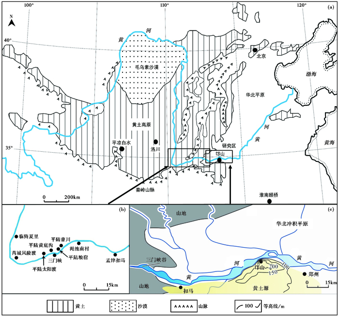
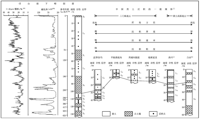
中国黄土堆积表现出较为明显的空间规律性,即从北向南,厚度逐渐减薄[1, 20],沉积速率逐渐降低[1, 23],粒度逐渐变细[1, 20~23]。该趋势得到了洛川[1]、西峰[24]及蓝田[25]等不同地区黄土剖面的支持。位于黄河中、下游交界处的邙山黄土(图 1),中更新世晚期(对应古土壤S2时期,绝对年龄在200ka左右,下同)以来堆积厚度近100m[10, 31~36],远大于洛川[1]、白水[5]等典型黄土剖面的同期堆积(图 2)。在厚度增加的同时,沉积速率明显加快[31~36],粒度也显著变粗[31~33, 37],这些都与中国黄土堆积的空间分布规律相悖。前人对中更新世晚期以来邙山黄土异常的厚度和极高的沉积速率进行了磁性地层学[31~35]、沉积学[10, 31~35]及释光年代学[10, 33~37]等综合研究工作,指出S2沉积(以下简称为S2)以来邙山附近冲积平原很可能是邙山黄土的主要源区,并认为S2以来邙山黄土厚度剧增、沉积加快、粒度变粗的现象与源区沉积特征的改变及黄河贯通三门峡有关[10, 31~35, 37]。然而,上述认识合理性如何?有否其他方面的证据支持?
|
图 1 研究区范围(a,b)以及标准黄土(a)和邙山黄土位置(c),据Zheng等[33]修改 Fig. 1 Locations of the studied area(a, b), sections of standard loess (a) and Mangshan loess (c), revised after Zheng et al.[33] |
|
图 2 邙山黄土剖面与其他典型黄土剖面对比图 Fig. 2 Correlation between Mangshan loess and other typical loess in stratigraphic, palaeomagnetic and sedimentological properties(see Fig.1 for locations) |
黄土的常量元素地球化学特征对源区特征反映较为敏感,常被用做物源示踪[1~6, 11, 12, 18, 19, 30, 38]。本文以S2为关键时间点,分析S2之前(L3~L5黄土)和S2以来(L1~L2黄土)邙山黄土的常量元素地球化学特征及其变化。为了从更大范围内把握规律,研究范围从邙山拓展到三门峡及其上游地区(图 1b和1c),乃至洛川[1]、白水[5]、淮南[6]等典型黄土剖面(图 1a)。除对比了相应时期风积物外,还对比了沿黄冲积物的常量元素地球化学特征,以探讨邙山黄土S2以来高速堆积及元素组分变化的原因,并尝试从元素地球化学的角度探讨邙山上游黄河水系的演化过程。
2 地貌背景及实验方法黄河是中国的第二大河,源起青藏高原,流经黄土高原、华北平原,最终东流入海。晋豫间的三门峡谷由一系列基岩山地组成,曾是黄河东流入海的最后一道屏障[35]。只有黄河贯通三门峡,其上游来水才能东流入海,故三门峡是探讨黄河发育演化的关键部位之一。黄河三门峡段西起平陆黄底沟,东至孟津扣马,长约150km,其间河谷狭窄,两岸陡峭,河床梯度大,水流速度快。黄河流出三门峡后,渐入华北平原,河谷极大拓宽,河水流速下降并发生堆积。邙山正处于黄河出三门峡基岩山地后进入华北平原的过渡位置(图 1c)。
邙山位于河南省郑州市西北25km的黄河南岸(图 1c),黄河北岸为宽阔的冲积平原,南岸为黄土塬,黄河向南岸摆动,形成侵蚀陡崖。邙山黄土塬东西长约18km,南北宽约5km,黄土塬面最高海拔262m[31~33],底部未见基岩出露。
邙山赵下峪剖面(34°58′N,113°22′E)位于河南省荥阳市高村镇刘沟村东,出露S10以上的黄土-古土壤序列,可见厚度达172m[32, 33]。通过与洛川[1]等黄土剖面的对比,结合前人的研究[13]和我们的工作,获得了该剖面S5沉积(以下简称为S5,中更新世早期,绝对年龄在600ka左右)以来的地层年代学框架(图 2)。本文选取L5以来不同层位的21个黄土样品进行了常量元素含量测试。其中,L1、L2、L4分别采样5个,L3、L5分别采样3个。样品在剖面中的具体位置如图 2所示。
为探究邙山黄土与其他区域黄土在空间上的关联性,我们对三门峡谷及其黄河上、下游地区的孟津扣马、平陆黄底沟、芮城风陵渡、临猗夏里(图 1b)L5以来的黄土也进行了采样,共采集20个黄土样品,样品在各剖面中的具体位置如图 2所示;此外,我们还采集了14个邙山上游黄河现代砂及黄河两岸阶地冲积物(以下简称为沿黄冲积物)砂样(图 1b),以探究邙山黄土与相同时代的沿黄冲积物在元素地球化学特征上的相关性,其中S2之前沿黄冲积物样品6个,S2之后沿黄冲积物样品8个,样品采集位置如图 1b所示。
所有样品的常量元素测试均在广州澳实实验测试中心完成。样品在室温下研磨至200目以下,采用Ⅹ荧光光谱法(XRF)测定,大部分常量元素的测试误差小于5%。
3 结果邙山黄土、三门峡地区黄土与沿黄冲积物样品的常量元素数据见表 1;我们还选取了研究程度较高的洛川[1]、平凉白水[5](简称为白水)和淮南顾桥[6](简称为淮南)的黄土剖面进行区域对比(图 1a),相关数据见表 2,表 2中UCC为上部陆壳平均化学成分,PAAS为后太古宙澳大利亚页岩,数据源于Taylor和McLennan[39]。
| 表 1 邙山黄土、三门峡地区黄土与沿黄冲积物常量元素数据(%) Table 1 Major element concentrations (%) of eolian deposits of Mangshan to the Sanmen Gorge sections, and the fluvial sediments along the Yellow River in the studied area |
| 表 2 洛川[1]、平凉白水[5]、淮南顾桥[6]黄土及UCC [39]、PAAS [39]常量元素数据(%) Table 2 Major element concentrations(%) of UCC[39], PAAS[39] and eolian deposits from sections of Luochuan[1], Baishui[5], Huainan[6] |
邙山黄土主要元素为SiO2、Al2O3和Fe2O3,这3种元素的质量百分含量总和在85.19% ~88.64%之间,平均为86.56%。其中,SiO2和Al2O3的平均含量分别为70.69%和11.85%。其次为CaO,质量百分含量变化范围在4.21% ~7.64%之间,平均为6.22%。Na2O、K2O和MgO的含量均在2%左右,TiO2、MnO2和P2O5的含量很低,均在1%以下(见表 1)。
三门峡地区黄土及沿黄冲积物的主要元素亦为SiO2、Al2O3和Fe2O3。相比于邙山黄土:1)三门峡地区黄土的SiO2含量偏低(66.79%),Al2O3的含量偏高(12.58%);2)沿黄冲积物的SiO2的含量偏高(75.47%),Al2O3的含量偏低(10.88%)。邙山黄土的SiO2、Al2O3含量介于三门峡地区黄土与沿黄冲积物之间(见表 1)。
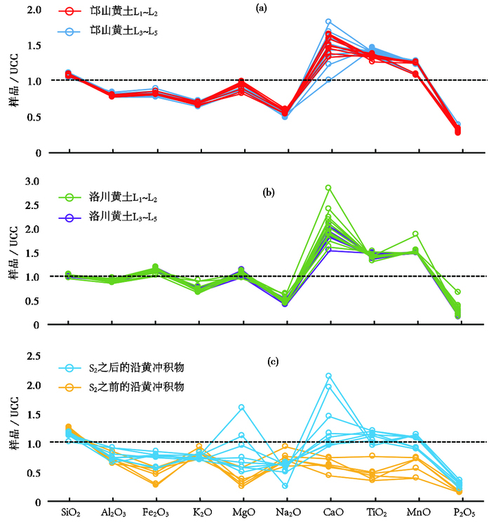
4 讨论 4.1 UCC标准化比较前人研究发现,风成沉积物在堆积前会经历多次搬运堆积循环,其化学成分与UCC趋于一致[40]。对邙山黄土、洛川黄土[1]及沿黄冲积物的常量元素进行UCC标准化后的结果(图 3)显示,相较于UCC,邙山黄土、洛川黄土[1]及S2之后沿黄冲积物的多数常量元素标准化后的数值均在1附近,尤其是SiO2、Al2O3、Fe2O3、K2O和MgO。反映了它们在堆积前,均经历了较为漫长的搬运过程,成分已趋均一化;而S2之前沿黄冲积物的多数常量元素较UCC偏离较大,可能反映其搬运距离较短,元素均一化程度不高。
|
图 3 邙山黄土(a)、洛川黄土(b)[1]与沿黄冲积物(c)的UCC[39]标准化图解 Fig. 3 UCC[39]-normalized abundances of major elements for the loess of Mangshan(a), Luochuan(b)[1] and the fluvial sediments(c) along the Yellow River of the studied area |
与洛川黄土[1]相比,邙山黄土、沿黄冲积物明显富SiO2而贫Al2O3(图 3)。不同时期来看,相对于邙山黄土L3~L5,邙山黄土L1~L2略富Na2O而贫TiO2,反映晚期邙山黄土的风化程度可能较低(图 3a);不同时期的洛川黄土[1]各元素含量相差不大(图 3b),而沿黄冲积物则在多数元素上表现出明显的时期差异(图 3c)。这些现象说明,L5以来的洛川黄土[1]物源较稳定,而研究区的风积物与冲积物的元素化学成分在S2前后都发生了较显著变化,反映邙山黄土与沿黄冲积物的物源可能在S2前后发生改变。
4.2 化学风化程度CIA是一种广泛使用的衡量陆地沉积物化学风化程度的指标,可以反映硅酸盐矿物的化学风化程度[41]。CIA=Al2O3/(Al2O3+CaO*+Na2O+K2O) ×100,其中,CaO*仅指赋存于硅酸盐矿物中的CaO[41]。本文采用McLennan[42]的方法对CaO的含量进行了校正。邙山等地黄土的CIA可以反映其化学风化程度,是因为富Al矿物尤其是高岭石在强烈的化学风化过程中大量产生,而富Na、Ca、K等元素的矿物如钙长石、钾长石等则在化学风化作用下分解流失,这都会使得CIA升高[3, 41, 43]。根据CIA进行化学风化阶段划分,CIA < 50为未受化学风化作用阶段,50 < CIA < 65为初等化学风化作用阶段,65 < CIA < 85为中等化学风化作用阶段,CIA>85为强烈化学风化作用阶段[44]。
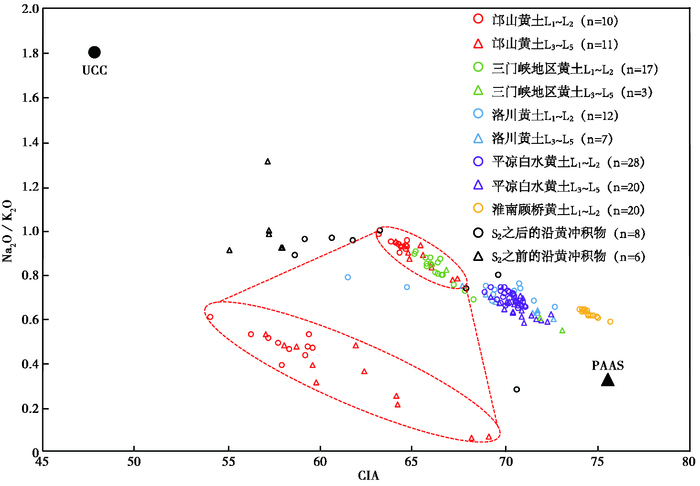
Na2O/K2O是反映长石风化程度的常用指标[9, 45],因为在化学风化过程中,Na2O比K2O更容易迁移和流失,Na2O/K2O值的高低往往与长石的化学风化程度相反[9]。邙山黄土、其他地区黄土及沿黄冲积物的CIA-Na2O/K2O图解(图 4)显示,各地样品与UCC[39]、PAAS[39]之间近似构成一条负斜率直线,CIA与Na2O/K2O均是化学风化程度有效指标。
|
图 4 邙山黄土、其他地区黄土[1, 5, 6]及沿黄冲积物的CIA-Na2O/K2O图解 Fig. 4 CIA versus Na2O/K2O plot for UCC[39], PAAS[39] and the loess of Mangshan, Luochuan[1], Baishui[5], Huainan[6] and the fluvial sediments along the Yellow River of the studied area |
邙山黄土的CIA在63.31~67.48之间,平均为64.98,显著小于三门峡地区黄土(67.08)、洛川黄土[1](69.55)、白水黄土[5](70.60)和淮南黄土[6](74.64)的CIA均值,但高于沿黄冲积物(61.10)。总体来看,邙山黄土的化学风化程度介于沿黄冲积物与其他地区黄土之间,处于初等化学风化作用阶段(图 4)。
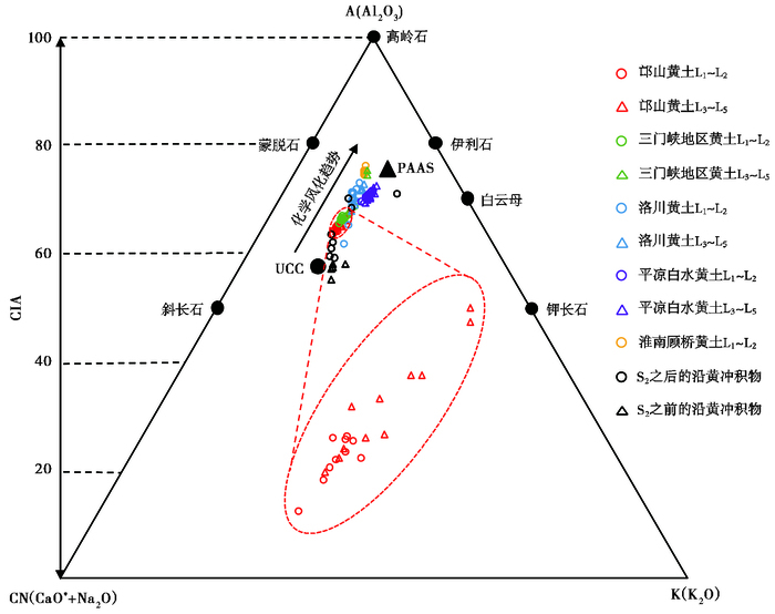
A-CN-K(Al2O3-CaO* +Na2O-K2O)三角图解是一种用于反映化学风化程度、矿物及常量元素变化的图解,自从Nesbitt和Young[41]于1982年提出后,已被广泛用于众多地区黄土风化程度的研究中[2~6, 12]。邙山黄土、其他地区黄土及沿黄冲积物的A-CN-K三角图解(图 5)显示,沿黄冲积物与邙山、洛川[1]、白水[5]、淮南黄土[6]大致沿着化学风化趋势线(从UCC到PAAS构成了典型的陆源沉积物风化趋势线[8, 46]),化学风化作用程度逐渐增强。从三角图解中还可以看出,邙山黄土的化学风化程度较低,Na、Ca开始流失但脱K并不明显,处于斜长石风化的初级阶段,生成伊利石、蒙脱石等粘土矿物[45]。
|
图 5 邙山黄土、其他地区黄土[1, 5, 6]及沿黄冲积物的A-CN-K图解 Fig. 5 A-CN-K triangular diagram for UCC[39], PAAS[39] and the loess of Mangshan, Luochuan[1], Baishui[5], Huainan[6] and the fluvial sediments along the Yellow River of the studied area |
前人研究表明,L1~L2时期的淮南黄土与洛川[1]等典型黄土同源[6]。淮南地处东南(图 1a),相比于西北方向的洛川[1]、白水[6]黄土偏湿热,故其化学风化程度更高(图 4和5)。邙山黄土亦处于洛川[1]、白水黄土[6]的东南方向,地处相对温湿的平原地带(图 1a),若它们同源,邙山黄土理应拥有更高的化学风化程度。但不同时期邙山黄土的化学风化程度均显著低于另两处典型黄土,更靠近沿黄冲积物。化学风化程度的巨大反差,可能反映了邙山黄土与洛川[1]、白水[6]、淮南黄土[6]的物源并不完全一致。
S2前后的邙山黄土在化学风化程度上亦有明显差别。从CIA-Na2O/K2O图解(图 4)和A-CN-K图解(图 5)中不难发现,L1~L2时期邙山黄土的CIA值更低、Na2O/K2O更高,A-CN-K三角图解中的投影区域更加靠近UCC,反映S2以来的邙山黄土化学风化程度低。邙山黄土在S2前后风化程度的差异,表明不同时期邙山黄土的物源可能有所变化。
S2前后沿黄冲积物的风化程度也出现了明显差异。S2以来的沿黄冲积物CIA值更高(图 4),A-CN-K三角图解(图 5)中的投影区域更加远离UCC,反映S2之后沿黄冲积物的化学风化程度更高。S2前后沿黄冲积物风化程度的差异,可能是其物源改变的重要指征。
4.3 稳定元素比值SiO2、Al2O3和TiO2这3种被认为是在化学风化过程中较为稳定的元素,它们一般不会随着风化作用的进行而流失,反而常常原地富集[47~50]。就沉积物而言,它们之间的比值会在风化过程中保持不变[2, 8, 9, 38, 50, 51]。因此,SiO2/Al2O3、SiO2/TiO2和TiO2/Al2O3具有良好的物源指示意义,亦已在黄土的物源研究中被广泛使用[2~6, 11]。
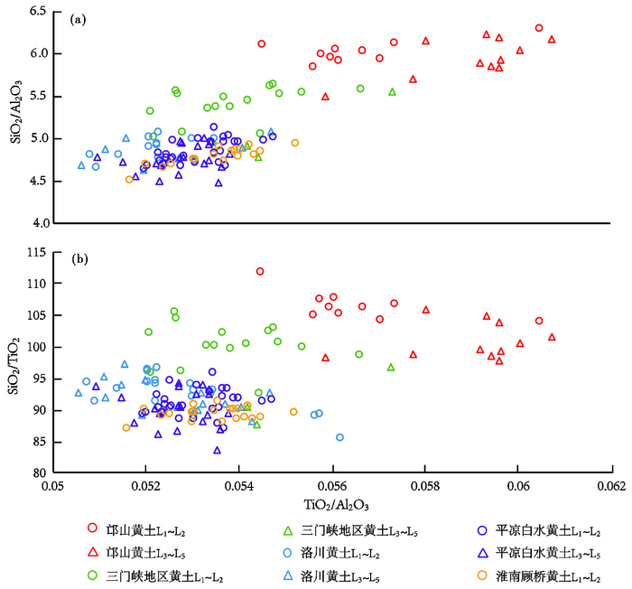
前人研究表明[52, 53],SiO2倾向于富集在粗颗粒物质中而Al2O3则倾向于富集在细颗粒物质中。因此,随着与物源距离的增大,风成沉积物的粒度会逐渐减小,SiO2/Al2O3也会逐渐降低[2]。SiO2/Al2O3与风积物粒度之间有明显的正相关关系,已被用作研究黄土粒度的替代性指标[2, 52, 53]。TiO2/Al2O3几乎不受黄土粒径及风化作用影响,也是研究风积物物源的重要指标[2, 51]。在TiO2/Al2O3-SiO2/Al2O3(图 6a)中,邙山黄土的Si2/Al2O3、TiO2/Al2O3明显偏高,反映其粒度可能偏大。洛川[1]、白水黄土[5]来源于西北沙漠[2, 4, 5, 18, 29, 38],若邙山黄土与之同源,理应具有偏小的粒度,既较小的SiO2/Al2O3。如此强烈的反差,说明邙山黄土与洛川[1]、白水黄土[5]的物源并非完全一致。
|
图 6 邙山黄土与其他地区黄土[1, 5, 6]的TiO2/Al2O3-SiO2/Al2O3(a)、TiO2/Al2O3-SiO2/TiO2(b)图解 Fig. 6 TiO2/Al2O3 versus SiO2/Al2O3 (A) and TiO2/Al2O3 versus SiO2/TiO2 (B) plots for the loess of Mangshan, Luochuan[1], Baishui[5] and Huainan[6] |
相比于风积物,富SiO2贫Al2O3是河流冲积物的典型特征[3, 11]。邙山黄土明显偏高的SiO2/Al2O3(图 6a)以及更加靠近沿黄冲积物的SiO2、Al2O3元素含量(图 3c),说明邙山黄土可能含有近源冲积物成分。
TiO2性质稳定,含量变化幅度小[1, 54]。SiO2/TiO2主要反映的是SiO2或石英含量的变化,它是一种对原始粉尘粒度更为灵敏的指标[54~56]。图 6b中邙山黄土较高的SiO2/TiO2,可能说明其SiO2或石英含量偏高、粒度偏粗。SiO2/TiO2的差异,是邙山黄土与洛川[1]、白水黄土[5]物源差异的又一指征。
前人关于邙山黄土粒度的研究显示[31~34](图 2),邙山黄土L5以来>45μm的粗颗粒组分含量大致在10% ~40%之间,这是一种以粗粉砂为主的砂黄土[31, 32]。从元素地球化学的角度,图 6也同样说明,邙山黄土的粒度组成比黄土高原腹地要粗得多,与靠近毛乌素沙漠的砂黄土类似[31],暗示邙山黄土含有较多近源成分,并非全是远源物质。
从图 2可以看出,大致以S2为界,邙山黄土粒度在上、下部有较大差异。S2以下的黄土,>45μm的粗颗粒含量大致在10% ~30%之间,而S2以上黄土>45μm的粗颗粒含量大致在10% ~45%之间,S2之后的黄土粒度较粗。图 6b也可以看出同样的趋势。L1~L2时期的邙山黄土比L3~L5时期的邙山黄土具有更高的SiO2/TiO2,这可能意味着晚期黄土中石英含量的增加,粒度的增大。图 6a和6b均可以看出,不同时期邙山黄土的TiO2/Al2O3迥异。SiO2/TiO2、TiO2/Al2O3在不同时期邙山黄土地层中的改变,可能反映了其S2前后物源的变化。
图 6可以看出,TiO2/Al2O3、SiO2/Al2O3和SiO2/TiO2均可有效区分邙山与洛川等其他地区黄土的粒度差别,但TiO2/Al2O3和SiO2/Al2O3对不同时期邙山黄土的粒度变化反映不敏感。这说明,对于近源堆积而言,SiO2/TiO2可能是比TiO2/Al2O3和SiO2/ Al2O3更好的粒度指标。因为近源堆积往往搬运过程短,风化作用不充分,使得Al在粗、细组分中均有富集,而Si、Ti的富集矿物对风化作用不敏感,故相比于TiO2/Al2O3和SiO2/Al2O3,SiO2/TiO2能更好地反映近源堆积的粒度变化。
4.4 沿黄冲积物与邙山黄土S2前后的沿黄冲积物在元素地球化学特征上具有明显的差异性:1) S2之前沿黄冲积物的多数常量元素偏离UCC的程度更高(图 3c);2)活跃元素方面,S2之后沿黄冲积物的Fe2O3、MgO偏高而Na2O、K2O含量偏低(图 3c),化学风化程度较高(图 4和5);3)稳定元素方面,S2前后沿黄冲积物的SiO2、Al2O3含量差异较小,但TiO2含量差异显著(图 3c)。河流冲积物的搬运营力不同于风力,稳定元素比值并不能反映其粒度变化。与SiO2、Al2O3相比,TiO2是一种含量较低,但对物源变化更为敏感的稳定元素[48, 54]。S2前后沿黄冲积物在TiO2含量上的显著差异,可能是其物源变化的重要指征。
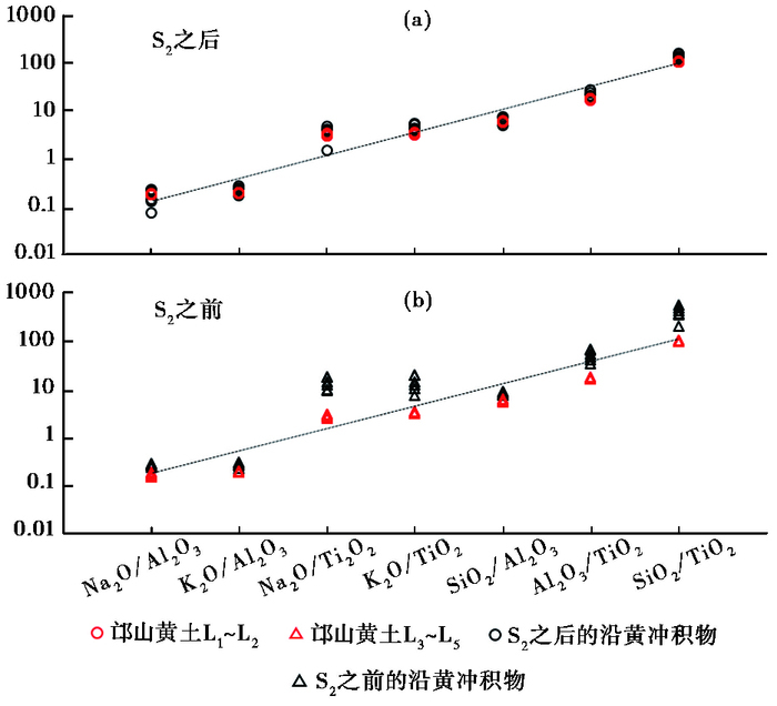
前文指出,邙山黄土与洛川等[1, 5, 6]典型黄土在元素含量(图 3)、化学风化程度(图 4和5)、稳定元素比值(图 6)等方面差异明显,说明它们在物源上有一定的差异性,邙山黄土很可能混有较多近源冲积物成分。若邙山黄土与近源冲积物之间存在成因联系,则在常量元素地球化学特征上必定有所反映。Na2O/Al2O3、K2O/Al2O3、Na2O/TiO2、K2O/TiO2等4个活跃与稳定元素的比值以及SiO2/Al2O3、Al2O3/TiO2、SiO2/TiO2等3个稳定元素之间的比值已被广泛用于分析黄土物源[1~6, 11, 12, 18, 19, 38],我们据此分析邙山黄土与沿黄冲积物地球化学特征之间的相关关系。结果显示(图 7),邙山黄土与沿黄冲积物之间表现出较为明显的相关性,且S2之后与冲积物的相关性更大,暗示两者之间存在成因联系。即从元素地球化学角度分析,邙山黄土的确含有近源冲积物组分。
|
图 7 S2前后邙山黄土与沿黄冲积物地球化学特征之间的相关性纵坐标为不同样品元素的比值 Fig. 7 The corresponding relations between the Mangshan loess and the fluvial sediments along the Yellow River of the studied area in geochemical characteristics, before and after S2. The ordinate axis is element ratios of the samples |
邙山地处黄河冲出三门峡谷的出口位置,奔腾于三门峡谷的河水出峡谷后,河床极大拓宽(图 1c),流速迅速降低,形成冲积平原[10, 31~35, 57]。强大的冬季风掠过平原,扬起的河流冲积物被再次搬运并堆积于邙山。结合前人关于邙山黄土粒度[10, 31~34, 37]、沉积速率[10, 31, 34~37]的研究,进一步表明邙山黄土与沿黄冲积物之间存在密切的成分关系。
S2以来,从洛川[1]、白水[5]到临猗夏里、芮城风陵渡、平陆黄底沟,黄土厚度逐渐减薄,这与中国黄土厚度的区域变化规律相一致(图 2)。孟津扣马临近三门峡谷谷口(图 1c),S2之前厚度异常不明显,但S2以来沉积明显偏厚(图 2)。若把孟津扣马L3~L5黄土和平陆黄底沟L1~L2黄土近似看成远源降尘的正常厚度(图 2),那么,邙山赵下峪L3~L5黄土厚度是同期扣马黄土厚度的近3.5倍,邙山赵下峪L1~L2黄土厚度则是同期平陆黄底沟黄土厚度的近10倍!同时,就邙山赵下峪黄土自身而言,S2以来的黄土厚度是S2之前的近3倍(表 3)。上述现象很可能意味着:1)邙山附近河谷显著展宽,黄土堆积厚度也随之加大,除了大气远源降尘外,还有风力吹扬的近源冲积物加入;2) S2之后河床堆积猛增,导致吹扬组分显著增加,黄土厚度也随之明显增大。两者均与前面的元素地球化学特征分析结果相吻合。
| 表 3 S2前后邙山黄土受近源冲积物影响表现出的厚度变化(剖面厚度见图 2) Table 3 Coeval changes between the Mangshan loess thickness and the adjacent fluvial sediments supply, before and after S2 (see fig. 2 for locations and thickness) |
三门峡是黄河东流入海的最后一个峡谷,其贯通与否,是影响黄河下游沉积物来源、搬运营力大小、沉积作用强弱的重要因素。只有三门峡被贯通,其上游巨量物质才有可能被持续搬运至下游[10, 31~35]。因此,黄河贯通三门峡的时代,也是其下游地貌与沉积特征发生重要变化的时刻[31, 32]。
邙山赵下峪黄土的沉积特征(图 2)、元素地球化学特征(图 3~6)及与沿黄冲积物的相关性分析(图 7)均表明,S2前后是邙山黄土沉积、河流沉积的重大转型期。用三门峡贯通来解释可能是比较合理的,即大约200ka前后的间冰期,三门峡谷溯源侵蚀,终于沟通了三门古湖[57~59],导致巨量水砂下泄,在三门峡谷下游形成宽广的冲积平原[10, 31~35, 57]。冬季风扬起的河流冲积物再次搬运并堆积于邙山,形成现今所见邙山黄土的厚度、沉积速率、粒度以及元素地球化学特征突变的现象。
三门峡贯通后,河流长度、流域面积、水砂量均极大增加。由于河流的下切速率与河流长度为指数正相关[60, 61],贯通后的三门峡水系连接了三门古湖及其上游的黄河水系,河流长度极大地增加,河流下切速率亦随之加大。根据阶地上覆黄土年代及高差数据[62, 63],相比于早更新世-中更新世晚期(0.3~1.8Ma)三门峡谷内较低的河流平均下切速率(VS2-S22=0.09mm/a),中更新世晚期-晚更新世(0.1~0.2Ma)的平均下切速率(VS1-S2)和晚更新世(0.1Ma)以来的下切速率(VS1)分别增加至0.26mm/a和0.49mm/a,增量为VS2-S22的2.8倍和5.4倍。三门峡与上游的三门古湖连接后,河流长度大幅加长,流域面积随之拓宽,导致进入河流的物质量急增。来自峡谷上游的巨量水砂下泄进入三门峡后,被搬运至峡谷下游并发生堆积[64~66]。三门峡谷内S2覆盖下的阶地拔河高度明显增加(将另文讨论)以及郑州以东200ka后剧增的冲积物厚度[67~69],都是三门峡贯通后河流下切速率增大、河流水砂量急增等现象更进一步的佐证。
因此,虽然不排除200ka之前三门峡与上游是沟通的可能[70~72],但200ka前后的沟通确实是黄河发展演化史上的重要事件。
5 结论本文获得了邙山、三门峡及其上游等地黄土及沿黄冲积物共55个样品的常量元素测试结果,通过UCC标准化对比、化学风化程度(CIA值、CIA对Na2O/K2O图解以及A-CN-K三角图解)研究以及稳定元素比值(SiO2/Al2O3、SiO2/TiO2、TiO2/ Al2O3)作图,得到了如下结果:
(1) 邙山黄土(L1~L5)与同时代的西北或东南典型黄土均有差异,邙山黄土的CIA值更低,A-CN-K三角图解中显示的化学风化程度也更低,并且邙山黄土的SiO2/Al2O3及SiO2/TiO2等稳定元素比值偏高,石英(SiO2)含量更高、粒度更粗,暗示邙山黄土与典型黄土的物源并非完全相同,特别是S2以来,邙山黄土相对于典型黄土的差异更加明显。
(2) 不同时期(S2之前与之后)沿黄冲积物UCC对比、CIA-Na2O/K2O、A-CN-K等图解所反映的元素地球化学特征也出现了显著的改变。
(3) 元素地球化学特征显示,邙山黄土与沿黄冲积物之间存在较大的相关关系,特别是在S2之后,黄土与冲积物的相关度更加明显。
上述现象均表明,近源冲积物是邙山黄土的重要补给源。大约200ka前后,冲积物元素地球化学特征发生了显著变化,邙山黄土也随之出现石英含量增高、沉积粒度加大、风化程度降低、沉积厚度急增等突变。这些现象很可能是上游沟通三门古湖、三门峡全线贯通的表现。这次贯通事件,不但表现在沿黄冲积物以及邙山黄土元素地球化学特征的显著改变上,而且在沉积物宏观特征上也有印证,同时邙山下游增厚的冲积物也是佐证。
致谢 匿名评审专家的宝贵意见对提高论文质量有重要帮助,特致谢忱。
| 1 |
刘东生等. 黄土与环境. 北京: 科学出版社, 1985, 1-302. Liu Tungsheng et al. Loess and Environment. Beijing: Science Press, 1985, 1-302. |
| 2 |
Hao Q Z, Guo Z T, Qiao Y S et al. Geochemical evidence for the provenance of Middle Pleistocene loess deposits in Southern China. Quaternary Science Reviews, 2010, 29(23-24): 3317-3326. DOI:10.1016/j.quascirev.2010.08.004 |
| 3 |
Guan H C, Zhu C, Zhu T X et al. Grain size, magnetic susceptibility and geochemical characteristics of the loess in the Chaohu Lake basin:Implications for the origin, palaeoclimatic change and provenance. Journal of Asian Earth Sciences, 2016, 117: 170-183. DOI:10.1016/j.jseaes.2015.12.013 |
| 4 |
Li Y, Song Y G, Chen X L et al. Geochemical composition of Tajikistan loess and its provenance implications. Palaeogeography, Palaeoclimatology, Palaeoecology, 2016, 446: 186-194. DOI:10.1016/j.palaeo.2016.01.025 |
| 5 |
Xiong S F, Ding Z L, Zhu Y J et al. A~6Ma chemical weathering history, the grain size dependence of chemical weathering intensity, and its implications for provenance change of the Chinese loess red clay deposit. Quaternary Science Reviews, 2010, 29(15): 1911-1922. |
| 6 |
Zhang L, Qin X G, Liu J Q et al. Geochemistry of sediments from the Huaibei Plain(East China):Implications for provenance, weathering, and invasion of the Yellow River into the Huaihe River. Journal of Asian Earth Sciences, 2016, 121: 72-83. DOI:10.1016/j.jseaes.2016.02.008 |
| 7 |
Chen Jun, Ji Junfeng, Qiu Gang et al. Geochemical studies on the intensity of chemical weathering in Luochuan loess-paleosol sequence, China. Science in China(Series D): Earth Sciences, 1998, 41(3): 235-241. DOI:10.1007/BF02973110 |
| 8 |
Gallet S, Jahn B, Torii M. Geochemical characterization of the Luochuan loess-paleosol sequence, China, and paleoclimatic implications. Chemical Geology, 1996, 133(1-4): 67-88. DOI:10.1016/S0009-2541(96)00070-8 |
| 9 |
Chen Jun, An Zhisheng, Liu Lianwen et al. Variations in chemical compositions of the eolian dust in Chinese Loess Plateau over past 2.5Ma and chemical weathering in the Asian inland. Science in China(Series D): Earth Sciences, 2001, 44 (5):403~413
|
| 10 |
蒋复初, 吴锡浩, 孙东怀等. 中原邙山黄土地层. 地质力学学报, 1998, 4(4): 12-18. Jiang Fuchu, Wu Xihao, Sun Donghuai et al. On Mangshan loess stratigraphy in China Central Plains. Journal of Geomechanics, 1998, 4(4): 12-18. |
| 11 |
Peng S Z, Hao Q Z, Wang L et al. Geochemical and grain-size evidence for the provenance of loess deposits in the Central Shandong Mountains region, Northern China. Quaternary Research, 2016, 85(2): 290-298. DOI:10.1016/j.yqres.2016.01.005 |
| 12 |
Jahn B, Gallet S, Han J M. Geochemistry of the Xining, Xifeng and Jixian sections, Loess Plateau of China:Eolian dust provenance and paleosol evolution during the last 140ka. Chemical Geology, 2001, 178(1-4): 71-94. DOI:10.1016/S0009-2541(00)00430-7 |
| 13 |
Heslop D, Langereis C G, Dekkers M J. A new astronomical timescale for the loess deposits of Northern China. Earth and Planetary Science Letters, 2000, 184(1): 125-139. DOI:10.1016/S0012-821X(00)00324-1 |
| 14 |
丁仲礼, 余志伟, 刘东生. 中国黄土研究新进展(三)时间标尺. 第四纪研究, 1991(4): 336-348. Ding Zhongli, Yu Zhiwei, Liu Tungsheng. Progress in loess research(Part3):Time scale. Quaternary Sciences, 1991(4): 336-348. |
| 15 |
Kukla G, An Z S. Loess stratigraphy in Central China paleogeography. Palaeogeography, Palaeoclimatology, Palaeoecology, 1989, 72(89): 203-225. |
| 16 |
An Z S, Kukla G, Porter S et al. Magnetic susceptibility evidence of monsoon variation on the Loess Plateau of Central China during the last 130, 000 years. Quaternary Research, 1991, 36(1): 29-36. DOI:10.1016/0033-5894(91)90015-W |
| 17 |
Hao Q Z, Guo Z T. Spatial variations of magnetic susceptibility of Chinese loess for the last 600 kyr:Implications for monsoon evolution. Journal of Geophysical Research:Atmospheres, 2005, 110(B12): 501-509. |
| 18 |
Guo Z T, Peng S Z, Hao Q Z et al. Origin of the Miocene-Pliocene red-earth formation at Xifeng in Northern China and implications for paleoenvironments. Palaeogeography, Palaeoclimatology, Palaeoecology, 2001, 170(1-2): 11-26. DOI:10.1016/S0031-0182(01)00235-8 |
| 19 |
Ding Z L, Sun J M, Yang S L et al. Geochemistry of the Pliocene red clay formation in the Chinese Loess Plateau and implications for its origin, source provenance and paleoclimate change. Geochimica et Cosmochimica Acta, 2001, 65(6): 901-913. DOI:10.1016/S0016-7037(00)00571-8 |
| 20 |
Ding Z L, Derbyshire E, Yang S L et al. Stacked 2.6-Ma grain size record from the Chinese loess based on five sections and correlation with the deep-sea δ18O record. Paleoceanography, Palaeoclimatology. Palaeoecology, 2002, 17(3): 5-1-5-21. |
| 21 |
殷志强, 秦小光, 李玉梅等. 源区距离对黄土粒度多组分分布特征的影响. 中国地质, 2008, 35(5): 1037-1044. Yin Zhiqiang, Qin Xiaoguang, Li Yumei et al. Influence of the dust source distance on the multimodal grain-size distribution characteristics of loess. Geology in China, 2008, 35(5): 1037-1044. |
| 22 |
Ding Z L, Sun J M, Rutter W N et al. Changes in sand content of loess deposits along a north-south transect of the Chinese Loess Plateau and the implications for desert variations. Quaternary Research, 1999, 52(1): 56-62. DOI:10.1006/qres.1999.2045 |
| 23 |
Douglas W B, Li J. Age and paleoclimatic significance of the loess of Lanzhou, North China. Nature, 1985, 316(6027): 429-431. DOI:10.1038/316429a0 |
| 24 |
Kukla G. Loess stratigraphy in Central China. Quaternary Science Reviews, 1987, 6(3-4): 191-219. DOI:10.1016/0277-3791(87)90004-7 |
| 25 |
Zheng H B, An Z S, Shaw J. New contributions to Chinese Plio-Pleistocene magnetostratigraphy. Physics of the Earth & Planetary Interiors, 1992, 70(3-4): 146-153. |
| 26 |
Vidic N J, Singer M J, Verosub K L. Duration dependence of magnetic susceptibility enhancement in the Chinese loess-palaeosols of the past 620 ky. Palaeogeography, Palaeoclimatology, Palaeoecology, 2004, 211(3-4): 271-288. DOI:10.1016/j.palaeo.2004.05.012 |
| 27 |
王荣华, 郭雪莲, 蒲宗文. 兰州九州台"上粉砂层"黄土L9的剩磁记录特征研究. 第四纪研究, 2016, 36(5): 1139-1153. Wang Ronghua, Guo Xuelian, Pu Zongwen. The paleomagnetic record of the upper sandy loess L9 in Jiuzhoutai section, Lanzhou. Quaternary Sciences, 2016, 36(5): 1139-1153. |
| 28 |
强小科, 徐新文, 陈艇等. 黄土高原黄土序列松山-布容地磁极性倒转界线空间分布特征与影响因素探讨. 第四纪研究, 2016, 36(5): 1125-1138. Qiang Xiaoke, Xu Xinwen, Chen Ting et al. Spatial characteristics and influencing factors of Matuyama-Brunhes polarity reversal boundary (MBB) in eolian sequences from the Chinese Loess Plateau. Quaternary Sciences, 2016, 36(5): 1125-1138. |
| 29 |
Sun J M. Provenance of lows material land formation of loess deposits on the Chinese Loess Plateau. Earth and Planetary Science Letters, 2002, 203(3-4): 845-859. DOI:10.1016/S0012-821X(02)00921-4 |
| 30 |
李楠, 郝青振, 张绪教等. 东秦岭黄土物源的常量元素和微量元素地球化学证据. 第四纪研究, 2016, 36(2): 332-346. Li Nan, Hao Qingzhen, Zhang Xujiao et al. Geochemical evidence for the provenance of loess deposits in the eastern Qinling Mountains, Central China. Quaternary Sciences, 2016, 36(2): 332-346. |
| 31 |
Jiang F C, Fu J L, Wang S B et al. Formation of the Yellow River, inferred from loess-palaeosol sequence in Mangshan and lacustrine sediments in Sanmen Gorge, China. Quaternary International, 2007, 175(1): 62-70. DOI:10.1016/j.quaint.2007.03.022 |
| 32 |
季军良, 郑洪波, 刘锐等. 邙山黄土地层再研究. 海洋地质与第四纪地质, 2004, 24(4): 101-108. Ji Junliang, Zheng Hongbo, Liu Rui et al. Restudy on the stratigraphy of Mangshan loess. Marine Geology & Quaternary Geology, 2004, 24(4): 101-108. |
| 33 |
Zheng H B, Yang X D, Ji J L et al. Ultra-high rates of loess sedimentation at Zhengzhou since Stage 7:Implication for the Yellow River erosion of the Sanmen Gorge. Geomorphology, 2007, 85(3-4): 131-142. DOI:10.1016/j.geomorph.2006.03.014 |
| 34 |
吴锡浩, 蒋复初, 肖华国等. 中原邙山黄土及最近200ka构造运动与气候变化. 中国科学(D辑):地球科学, 1999, 29(1): 75-81. Wu Xihao, Jiang Fuchu, Xiao Huaguo et al. Mangshan loess in China central plains and its tectonic movement & climate change since 200ka. Science in China (Series D):Earth Sciences, 1999, 29(1): 75-81. |
| 35 |
蒋复初, 傅建利, 王书兵等. 关于黄河贯通三门峡的时代. 地质力学学报, 2005, 11(4): 293-301. Jiang Fuchu, Fu Jianli, Wang Shubin et al. The age of the Yellow River passing thought the Sanmen Gorge. Journal of Geomechanics, 2005, 11(4): 293-301. |
| 36 |
Qiu F Y, Zhou L P. A new luminescence chronology for the Mangshan loess-palaeosol sequence on the southern bank of the Yellow River in Henan, Central China. Quaternary Geochronology, 2015, 30: 24-33. DOI:10.1016/j.quageo.2015.06.014 |
| 37 |
Maarten A P, Zheng H B, Kay B et al. Dust supply from river floodplains:The case of the lower Huang He (Yellow River) recorded in a loess-palaeosol sequence from the Mangshan Plateau. Journal of Quaternary Sciences, 2009, 24(1): 75-84. DOI:10.1002/jqs.v24:1 |
| 38 |
顾兆炎, 韩家懋, 刘东生. 中国第四纪黄土地球化学研究进展. 第四纪研究, 2000, 20(1): 41-55. Gu Zhaoyan, Han Jiamao, Liu Tungsheng. Progress in geochemical research on the loess and other Quaternary deposits in China. Quaternary Sciences, 2000, 20(1): 41-55. |
| 39 |
Taylor S R, McLennan S M. The Continental Crust:Its Composition and Evolution. Oxford:Blackwell Scientific Pub., 1985. 38~43
|
| 40 |
Taylor S R, McLennan S M, Mcculloch M T. Geochemistry of loess, continental crustal composition and crustal model ages. Geochimica et Cosmochimica Acta, 1983, 47(11): 1897-1905. DOI:10.1016/0016-7037(83)90206-5 |
| 41 |
Nesbitt H W, Young G M. Early Proterozoic climates and plate motions inferred from major chemistry of lutites. Nature, 1982, 299(5885): 715-717. DOI:10.1038/299715a0 |
| 42 |
McLennan S M. Weathering and global denudation. The Journal of Geology, 1993, 101(2): 295-303. DOI:10.1086/648222 |
| 43 |
Guo Z T, Liu T S, Guiot J et al. High frequency pulses of East Asian monsoon climate in the last two glaciations:Link with the North Atlantic. Climate Dynamics, 1996, 12(10): 701-709. DOI:10.1007/s003820050137 |
| 44 |
Fedo C M, Nesbitt H W, Young G M. Unraveling the effects of potassium metasomatism in sedimentary rocks and paleosols, with implications for paleoweathering conditions and provenance. Geology, 1995, 23(10): 921-924. DOI:10.1130/0091-7613(1995)023<0921:UTEOPM>2.3.CO;2 |
| 45 |
Nesbitt H W, Markovics G, Price R C. Chemical processes affecting alkalis and alkaline earths during continental weathering. Geochimica et Cosmochimica Acta, 1980, 44(11): 1659-1666. DOI:10.1016/0016-7037(80)90218-5 |
| 46 |
李传想, 宋友桂. 新疆伊犁黄土化学风化特征及其控制因素. 高校地质学报, 2011, 17(4): 611-619. Li Chuanxiang, Song Yougui. Chemical weathering characteristics and controlling factors of the Ili loess, Xinjiang. Geological Journal of China Universities, 2011, 17(4): 611-619. |
| 47 |
文启忠. 中国黄土地球化学. 北京: 科学出版社, 1989, 71-133. Wen Qizhong. Geochemistry of the Chinese Loess. Beijing: Science Press, 1989, 71-133. |
| 48 |
Sheldon N D, Tabor N J. Quantitative paleoenvironmental and paleoclimatic reconstruction using paleosols. Earth-Science Reviews, 2009, 95(1-2): 1-52. DOI:10.1016/j.earscirev.2009.03.004 |
| 49 |
Li Y H. A brief discussion on the mean oceanic residence time of elements. Geochimica et Cosmochimica Acta, 1982, 46(12): 2671-2675. DOI:10.1016/0016-7037(82)90386-6 |
| 50 |
Broecker W S, Peng T. Tracers in the Sea. New York: Eldigio Press, 1982, 26-31.
|
| 51 |
顾兆炎, 丁仲礼, 熊尚发等. 灵台红粘土和黄土-古土壤序列的地球化学演化. 第四纪研究, 1999(4): 357-365. Gu Zhaoyan, Ding Zhongli, Xiong Shangfa et al. A seven million geochemical record from Chinese red-clay and loess-paleosol sequence:Weathering and erosion in Northwestern China. Quaternary Sciences, 1999(4): 357-365. |
| 52 |
Peng Shuzhen, Guo Zhengtang. Geochemical indicator of original eolian grain size and implications on winter monsoon evolution. Science in China(Series D): Earth Sciences, 2001, 44(1): 261-266. |
| 53 |
Muhs D R, Bettis E A. Geochemical variations in Peoria loess of Western Lowa indicate paleowinds of Midcontinental North America during Last Glaciation. Quaternary Research, 2000, 53(1): 49-61. DOI:10.1006/qres.1999.2090 |
| 54 |
Liu T S, Guo Z T, Liu J Q et al. Variations of Eastern Asian monsoon over the past 140, 000 years. Bulletin de la Societe Geologique de France, 1995, 166(2): 221-229. |
| 55 |
Xiao J L, Porter S C, An Z S et al. Grain size of quartz as an indicator of winter monsoon strength on the Loess Plateau of Central China during the last 130, 000 yr. Quaternary Research, 1995, 43(1): 22-29. DOI:10.1006/qres.1995.1003 |
| 56 |
An Z S, Porter S C. Millennial-scale climatic oscillations during the last interglaciation in Central China. Geology, 1997, 25(7): 603-606. DOI:10.1130/0091-7613(1997)025<0603:MSCODT>2.3.CO;2 |
| 57 |
Zhang Z K, Wang S M, Yang X D et al. Evidence of a geological event and environmental change in the catchment area of the Yellow River at 0.15Ma. Quaternary International, 2004, 117(1): 35-40. DOI:10.1016/S1040-6182(03)00114-9 |
| 58 |
Wang Sumin, Wu Xihao, Zhang Zhenke et al. Sedimentary records of environmental evolution in the Sanmen Lake Basin and the Yellow River running through the Sanmen Gorge eastward into the sea. Science in China(Series D):Earth Sciences, 2002, 45 (7):595~608
|
| 59 |
张抗. 黄河中游水系形成史初探. 第四纪研究, 1989(1): 185-193. Zhang Kang. The development of drainage systems in the middle reaches of the Yellow River. Quaternary Sciences, 1989(1): 185-193. |
| 60 |
Goldrick G, Bishop P. Differentiating the roles of lithology and uplift in the steepening of bedrock river long profiles:An example from Southeastern Australia. The Journal of Geology, 1995, 103(2): 227-231. DOI:10.1086/629738 |
| 61 |
Goldrick G, Bishop P. Regional analysis of bedrock stream long profiles:Evaluation of Hack's SL form, and formulation and assessment of an alternative(the DS form). Earth Surface Processes and Landforms, 2007, 32(5): 649-671. DOI:10.1002/(ISSN)1096-9837 |
| 62 |
傅建利. 黄河三门峡段地貌发育与环境演变. 北京: 中国地质科学院博士研究生学位论文, 2009. 50~59 Fu Jianli. The Fluvio-lacustrine Landform Development and Environmental Change in the Sanmenxia Section of the Yellow River. Beijing:The Ph.D. Thesis of Chinese Academy of Geologecal Sciences, 2009. 50~59 |
| 63 |
梁浩. 中更新世晚期以来黄河晋陕-三门峡谷河流地貌演化及其对盆地贯通的响应. 广州: 中山大学博士研究生学位论文, 2017. 118~143 Liang Hao. Long-term Fluvial Evolution and Response to Basins Connection along the Jinshan-Sanmen Gorge, Yellow River since Late Mid-Pleistocene. Guangzhou:The Ph.D. Thesis of Sun Yat-Sen University, 2017. 118~143 |
| 64 |
王书兵, 蒋复初, 傅建利等. 关于黄河形成时代的一些认识. 第四纪研究, 2013, 33(4): 705-714. Wang Shubing, Jiang Fuchu, Fu Jianli et al. Some knowledge of the formation of the Yellow River. Quaternary Sciences, 2013, 33(4): 705-714. |
| 65 |
吴锡浩, 蒋复初, 王苏民等. 关于黄河贯通三门峡东流入海问题. 第四纪研究, 1998(2): 188. Wu Xihao, Jiang Fuchu, Wang Sumin et al. On problem of the Yellow River passing through the Sanmen Gorge and flowing east into sea. Quaternary Sciences, 1998(2): 188. |
| 66 |
石长青, 董玉良, 韩书华. 关于黄河三角洲形成问题的初步探讨. 地质论评, 1985, 31(6): 539-547. Shi Changqing, Dong Yuliang, Han Shuhua. Problems on the formation of the Huanghe (Yellow) River delta. Geological Review, 1985, 31(6): 539-547. |
| 67 |
马玉凤, 李双权, 潘星慧. 黄河冲积扇发育研究述评. 地理学报, 2015, 70(1): 49-62. Ma Yufeng, Li Shuangquan, Pan Xinghui. A review on development of the Yellow River alluvial fan. Acta Geographica Sinica, 2015, 70(1): 49-62. |
| 68 |
贾杰华, 石钦周, 王志刚等. 黄河冲积扇的形成及其水文地质环境. 人民黄河, 2002, 24(2): 19-20. Jia Jiehua, Shi Qinzhou, Wang Zhigang et al. Formation of the Yellow River alluvial fan and its hydro geological environment. Yellow River, 2002, 24(2): 19-20. |
| 69 |
李祥根. 黄河贯通与淮北灾变. 见: 卢演俦, 高维明, 陈国星等主编. 新构造与环境. 北京: 地震出版社, 2001. 168~170 Li Xianggen. The formation of the Yellow River and Huaibei catastrophe. In:Lu Yanchou, Gao Weiming, Chen Guoxing et al.eds. Neotectonics and Environment. Beijing:Earthquake Press, 2001. 168~170 |
| 70 |
杨守业, 蔡进功, 李从先等. 黄河贯通时间的新探索. 海洋地质与第四纪地质, 2001, 21(2): 15-20. Yang Shouye, Cai Jingong, Li Congxian et al. New discussion about the run-through time of the Yellow River. Marine Geology & Quaternary Geology, 2001, 21(2): 15-20. |
| 71 |
岳乐平, 雷祥义. 黄河中游水系的阶地发育时代. 地质论评, 1997, 43(2): 186-192. Yue Leping, Lei Xiangyi. The age of terrace development in the middle reaches of the Yellow River. Geological Review, 1997, 43(2): 186-192. |
| 72 |
Pan B T, Wang J P, Gao H S et al. Terrace dating as an archive of the run-through of the Sanmen Gorges. Progress in Natural Science:Materials International, 2005, 15(12): 1096-1103. DOI:10.1080/10020070512331343191 |
② Guangdong Provincial Key Laboratory of Mineral Resources and Geological Processes, Guangzhou 510275;
③ Institute of Geomechanics, Chinese Academy of Geological Sciences, Beijing 100081)
Abstract
As one of the most massive accumulations of loess in the world, the Chinese Loess Plateau (CLP) has become one of the key areas to study Quaternary environmental changes. The Mangshan (MS) loess section (34°58'N, 113°22'E) locates in the southeast corner of CLP adjacent to the vast North China Flood Plain and downstream to the Sanmen Gorge, which had been the last barrier for the Yellow River to flow eastward into the sea, leading to be a critical area for understanding the evolution of the Yellow River. The physical features of the MS loess such as extremely thickness, exceptionally high accumulation rates, lower magnetic susceptibility, and coarser grain-size, show close correlation to the regional environmental changes, particularly via the comparison with other typical sections of arid Luochuan (LC) and Baishui (BS) loess in the CLP, and humid Huainan (HN) loess south to the CLP. Due to its contrast features and critical location, it has attracted study on magnetostratigraphy, sedimentology and luminescence chronology, etc. of the MS loess. Our research finds the new evidences of the headward erosion, happened around 200ka between the Sanmen Basin and the Gorge, led to the provenance change of the MS loess, and the dramatic increases of the sediment flux along the river. This paper respectively correlates the MS loess to other typical loess sections, the MS loess to the fluvial deposits along or upstream of the gorge, the upper (L1~L2) section, and lower (L3~L5) section of the MS loess, focusing on major element geochemical characteristics, which bear the information about climate change and dust sources and can provide the insight into the evolutionary history in the Sanmen Gorge area of the Yellow River. Our results present:(1) Compared with the LC loess, the MS loess shows substantial differences in the relatively active elements (e.g. Na2O) and the relatively invariant elements (e.g SiO2, Al2O3, and TiO2); (2) Compared with the SM, LC, BS and HN loess, the MS loess with lower weathering intensity based on the CIA value and the A-CN-K plots reflects the source difference to the typical loess deposits in the CLP; (3) The MS loess with a higher SiO2/Al2O3, SiO2/TiO2, and TiO2/Al2O3 reflects a coarser grain-size and more quartz content. All of analyses indicate that the MS loess were derived from nearby area. Furthermore, UCC normalized graphs show that:(1) Compared with the LC loess, higher SiO2 and lower Al2O3 in the MS loess are consistent with that of the fluvial sediments; (2) The upper MS loess sections (L1~L2) characterized by exceptional thickness show a lower weathering intensity and a higher SiO2/TiO2 compared with the lower sections (L3~L5); (3) The MS loess kept similar pace with the fluvial sediments in the major element changes before and after S2. Results suggest that the MS loess probably were derived the fluvial sediments upstream of the MS and sudden change of sediment supply happened in S2. The transition in S2 can be witnessed via dramatic increase of sediment supply and excessive deposition of the alluvial fan induced by basins connection via headward erosion along the Sanmen Gorge. Such excessive deposit compensation provided an extra source for the loess accumulation in the MS area. 2017, Vol.37

