 2016, Vol.36


通过流域地貌特征探讨与评价区域新构造活动强度是当前活动构造研究的热点领域[1, 2, 3, 4, 5, 6, 7, 8],流域地貌参数分析成为定量、 半定量评价区域新构造运动的技术手段[9, 10, 11, 12, 13]。流域地貌发育对新构造活动极其敏感[14, 15],河道横、 纵剖面形态、 河床冲淤、 阶地的发育等都会因新构造活动产生相应的调整和响应,并影响到不同尺度的流域地貌,从而可以通过流域地貌参数的分析加以识别。DEM数据提供了流域分割和流域地貌参数快速有效提取的可能[2, 16, 17],成为目前新构造活动性定量评价的主要数据源之一。用于新构造活动研究的常用的流域地貌参数有流域面积-高程积分(HI)、 流域盆地不对称度(AF)、 山前曲折度(Smf)、 河长坡降指数(SL)、 盆地形状指数(Bs)等。
郯-庐断裂带是中国东部最重要的构造带之一[18]。研究表明,该断裂带自中生代以来存在反复的活动[19, 20]。沂沭断裂带是郯-庐断裂带的山东段,由4条主干断裂组成,自东向西依次为昌邑-大店断裂(F1)、 安丘-莒县断裂(也称白芬子-乳来山断裂)(F2)、 沂水-汤头断裂(F3)和鄌郚-葛沟断裂(F4),其中的F1和F2在第四纪活动性较强,以兼具逆冲活动的右旋走滑为主[21, 22, 23]; 目前,对F3、 F4的活动性认识仍存在较大分歧: 部分学者认为新近纪以来二者皆无活动迹象[22]; 另一部分学者认为二者在第四纪以来存在活动,且表现为右旋走滑[24, 25]。对断裂带活动的证据的研究主要包括断裂带内部构造形迹的相关构造地质研究[24, 26],以及众多的深部地震地质研究[27, 28, 29]。国内采用流域地貌研究以揭示区域新构造运动多集中于中、 西部地区,尤其是青藏高原的外围[6, 9, 30]。对断裂带新构造活动,乃至活动构造引起的流域地貌变化及河流地貌响应研究较少,从而缺乏对沂沭断裂带新构造活动研究领域的完整性的认识。事实上,断裂带的深部活动势必引起地表的一系列过程和变化,这也正是流域地貌分析、 探究其对构造活动响应的重要前提。当然,针对断裂活动存在分歧的流域部分,通过流域地貌特征的对比分析,有可能为断裂带的新构造活动性提供流域地貌上的证据。
1 研究区概况研究区位于山东省中部地区,地理坐标为 34°20′-37°08′N,117°07′-119°42′E,属鲁中南剥蚀构造山地丘陵区。区内地势西高东低,最高海拔1126m,位于蒙阴西南部的蒙山地区。区内水系发育,主要有与断裂带直交或斜交的白浪河、 潍河、 沭河、 沂河4大水系。区内的沂沭断裂带全长约315km,呈NE10°-25°向展布(图1)。F1-F4为“两堑夹一垒”的断层组合型式[26]。其中,F1、 F2之间发育一系列斜列式的活动断层(F5)[32],是1668年郯城大地震的同震发震断层区[33]。新近纪,沂沭断裂带发生挤压活动,发育大规模幔源玄武岩喷发[34]。断裂带内的中新统临朐群,其以玄武岩夹带少量粘土岩和砂砾岩为主,主要分布在沂水以北的东、 西地堑及汞丹山地垒内,沂水以南地区发育较差,仅在华侨以南的东地堑内有少量分布; 上新统尧山组以褐黑色橄榄玄武岩为主,主要分布在沂沭断裂带西侧昌乐附近及汞丹山地垒,少量分布于西地堑北部; 第四系主要有黑土湖组、 临沂组、 沂河组、 寒亭组和潍北组[24, 35],其中,临沂组和沂河组属河流相、 寒亭组属风成相、 黑土湖组属湖沼相、 潍北组属海陆交互相,它们主要分布在断裂带南部的沂河、 沭河流域以及北部的潍坊以北的昌潍平原。前人研究表明[23, 24],沂沭断裂带第四纪以来活动频繁,且分段活动性显著,整体上表现为东强西弱、 南强北弱的特点。活断层在F1-F4处均有分布,主要分布在F1的管帅-左山段,F2的中华山以南,F3圈里以南及F4中段[14, 21, 24]。

|
图1 沂沭断裂带新构造简图 断裂带及上新世以来的地层据1/100万山东省地震构造图[31] Fig.1 Neotectonic map of Yishu Fault Zone. All fault zones and stratigraphs of Pliocene are modified from 1/100 Seismotectonic Map of Shandong Province |
本文采用的SRTM DEM数据,数据像元分辨率约为90m×90m。利用ArcGIS软件中的Hydrology模块,首先进行洼地填充; 然后从无洼地的DEM中提取水流方向,并计算汇流累积量及水流长度,提取河网并将河网级别分为4个等级,最后对流域进行分割。选取覆盖断裂带的亚流域并进行删减得到148个亚流域。其中,白浪河34个亚流域; 潍河27个亚流域; 沂河40亚流域和沭河47个亚流域。另外,据河流名称及河网等级将亚流域进行统一编码,如白浪河3级河网弧段编码为B3-1,其中数字1为3级河网弧段在白浪河流域数量的按序编码,如图2; 其它3条河流以此类推。

|
图2 沂沭断裂带亚流域 B——白浪河(Bailang River); W——潍河(Weihe River); Y——沂河(Yihe River); S——沭河(Shuhe River) Fig.2 Catchments of Yishu Fault Zone |
首先提取亚流域地貌参数包括面积-高程积分值(HI)、 流域盆地不对称度(AF)、 河长坡降度(SL)和流域盆地形状指数(Bs),地貌参数通过ArcGIS按公式计算求取; 第二步是新构造活动强度级别的划分,其中,HI依据研究区各亚流域面积-积分曲线凹凸度特征进行划分[36],AF级别据Perez等[37]以AF与50的差值为依据划分标准进行划分,SL级别根据研究区亚流域Hack剖面凹凸度特征及Hack等[38]的分级标准进行划分,Bs级别依据以2、 3为临界值的划分标准进行划分[12]; 第三步对亚流域新构造活动性的综合评价。在亚流域各地貌参数的计算统计基础上,采用各地貌参数等级的平均值作为亚流域新构造活动性的综合判别指标,对亚流域各地貌参数指标进行整合,获取区域构造活动强度(Iat)值,按Hamdouni和Irigaray[39]的划分标准对Iat值划分等级,最后结合研究区地质背景和前人地震地质研究成果[23, 24, 25, 26, 27, 28, 29, 40, 41],对研究区新构造活动强度进行分析评价,尤其是流域新构造活动强度与活动构造之间的空间关系分析研究。流域地貌参数的计算及新构造含义如下:
(1)面积-高程积分(HI)与积分曲线
面积-高程积分即区域内不同海拔所占的相对面积百分比,用来描述区域内高程值分布指标。
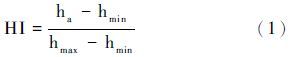
公式(1)中的ha为流域平均高程,hmax为流域最大高程,hmin为流域最小高程。
HI值的大小可反映流域盆地受侵蚀强度,进而反映流域构造活动强度。HI值偏大,侵蚀强度大,流域构造活跃; HI值偏小,侵蚀强度小,流域构造稳定[42, 43]。
积分曲线是以高于某一高程值的面积与流域总面积的比值为横轴,以高程值与流域高程差值的比例为纵轴,常用来判定地貌发育阶段。Strahler[36]的研究表明,积分曲线呈现下凹形,地貌发育处于老年期,HI值偏低(HI<0.35); 积分曲线呈现S形,地貌发育处于中年期,HI值中等(0.35<HI<0.6); 积分曲线呈现上凸形,地貌发育处于幼年期,HI值偏高(HI>0.6)。
(2)河长坡降度(SL)与Hack剖面
河长坡降度(SL)即“坡降指标”,用于定量反映河流剖面坡度的变化状况[44]。
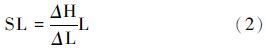
公式(2)中,ΔH/ΔL为单位河段坡度,其中,ΔH为单位河段高程差,ΔL为河段长度; L为河流源头至单位河段中点的距离。
Hack剖面是以单位河段至河流源头的距离取对数为横轴,以高程值为纵轴。 河流纵剖面曲线形态可以直观地反映出河流纵剖面整体变化趋势和特征[38]。
Hack剖面和SL值可以提供众多的新构造信息,对活动构造亦十分敏感。Hack剖面呈现上凸形,SL值偏大,指示流域存在区域差异隆升; 反之,SL值偏小,说明流域沉降[45]。Hack等[38]依据Hack剖面凹凸度将SL值分为3个等级:SL≥400,剖面上凸,构造活动较强; 200≤SL<400,剖面凹-凸变化,构造活动中等; SL<200,剖面下凹,构造活动弱。
(3)流域盆地不对称度(AF)
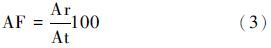
公式(3)中,Ar表示流域内干流右侧的面积,At表示流域总面积。
研究表明,流域盆地不对称度(AF)能够反映其受构造活动影响的倾斜程度[16]。∣AF-50∣的值越大,流域盆地倾斜程度越高,构造活动越强烈; 反之,构造活动越弱[12]。Perez等[37]将AF级别划分为3个等级:∣AF-50∣≥15,活动强度大; 7≤∣AF-50∣<15,活动强度中等; ∣AF-50∣<7,活动强度弱。
(4)流域盆地形状指数(Bs)
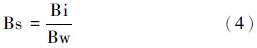
公式(4)中Bi为从流域内主河道与分水岭的交汇点至流域出口的直线距离,Bw为流域盆地最大宽度。
Bs值越大,流域盆地形状呈现狭长型,指示构造活动较强烈; Bs值越小,流域盆地越趋向于圆形,指示构造活动越弱[16]。可划分为3个等级:Bs≥3,活动程度强; 2≤Bs<3,活动程度中等; Bs<2,活动程度弱[12]。
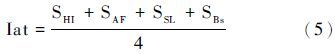
(5)相对构造活动强度(Iat)
即地貌参数构造活动等级的算术平均化。设构造活动强度等级为S,Iat值分为4级:1.0≤Iat<1.5,活动程度最强; 1.5≤Iat<2.0,活动程度强; 2.0≤Iat<2.5,活动强度中等; 2.5≤Iat≤3,活动强度弱[39]。
采用公式(1),计算出148个亚流域的HI值。其中最大值为0.35,位于S1-15亚流域; 最小值为0.09,位于B3-1亚流域。研究区内的流域积分曲线均呈下凹形,曲线的下凹程度依次由小到大,见图3,流域演化阶段处于老年期[34]。以差值0.1划分流域面积-高程积分曲线的HI值,分别为≥0.26、 0.15-0.26和<0.15。由上述HI等级所标定的流域分布见图4。从图4中可以看出,跨沂沭断裂带亚流域的HI值总体上呈中部大、 两端小的特征分布。其中,HI值等级高的亚流域位于鄌郚-马站一带的西地堑、 沂水-沂南一线以西及茅埠-莒县一线以东。

|
图3 3种亚流域面积-高程积分曲线 Fig.3 Three examples of different values of the hypsometric integral curve |

|
图4 沂沭断裂带亚流域面积-高程积分值(HI)等级分布图 Fig.4 Distribution of hypsometric integral classes of subbasins in Yishu Fault Zone |
根据公式(2)计算出每个亚流域的SL值。最大值为4511.96,位于Y1-7亚流域; 最小值为18.12,位于B2-2亚流域。对亚流域剖面数据处理得到的Hack剖面,具有3种形式,见图5。依据Hack剖面凹凸度,将SL值划分为3个等级:SL≥400,活动程度较强; 200≤SL<400,活动程度中等; SL<200,活动程度弱[38]。据此得到SL亚流域构造活动强度等级分布(图6)。

|
图5 Hack剖面的3种类型 Fig.5 Three examples of different values of Hack profile |

|
图6 沂沭断裂带亚流域坡降度指数(SL)等级分布图 地震分布据 1/100 万山东省地震构造图[31] Fig.6 Distribution of stream length-gradient index classes of subbasins in Yishu Fault Zone. The distribution of seismic is modified from 1/100 Seismotectonic Map of Shandong Province |
图6中,位于沂沭断裂带北部的白浪河、 中南部的沭河亚流域的SL值级别普遍较小; SL级别高的亚流域主要位于鄌郚-沂南一带的F3、 F4断裂之间及华侨以南的F1、 F2之间。SL异常峰值(SL>1000)包括:W1-3(SL=1237.61)位于安丘北部的汞丹山地垒内; Y1-9(SL=2759.62)和Y1-4(SL=1053.52)分别位于沂水以北的F4和F3断裂处; 极端峰值Y1-7(SL=4511.96)位于双湖村以南的F2断裂处,且由图6中可知,SL高值区及附近区域存在地震分布。
3.3 流域盆地不对称度(AF)根据公式(3)计算出每个亚流域的AF值。最大值为91.39,位于S2-3亚流域; 最小值为12.11,位于W2-1亚流域。根据Perez等[37]的分级标准得到研究区AF值等级分布见图7。其中,AF级别高的亚流域位于安丘-昌邑一带及浮来山-东莞一带的汞丹山地垒、 鄌郚-圈里一带的西地堑和大店-郯城一带的东地堑。

|
图7 沂沭断裂带亚流域盆地不对称度(AF)等级分布图 Fig.7 Distribution of drainage basin asymmetry classes of subbasins in Yishu Fault Zone |
依据公式(4)计算出每个亚流域的Bs值。最小值为0.06,位于W1-13亚流域; 最大值为12.11,位于Y4-2亚流域。据前人分级标准[12]得到流域盆地形状指数分布见图8。从图8中可以看出,Bs值强度等级总体呈现出南高、 北低的格局。Bs级别高的亚流域,西部位于葛沟以南,并沿沂河方向的F4一线; 东部位于左山以南、 中华山以北、 临沭以南及郯城东南部,与东地堑的空间关系密切。

|
图8 沂沭断裂带亚流域盆地形状指数(Bs)等级分布图 Fig.8 Distribution of Basin shape index classes of subbasins in Yishu Fault Zone |
按照公式(5),计算获得研究区各亚流域的Iat值为1.5-3.0。按前人4级划分标准[39],研究区内亚流域的Iat值包括(以构造活动划分): 强(1.5≤Iat<2.0)、 中等(2.0≤Iat<2.5)和弱(2.5≤Iat≤3.0)共3个级别。Iat等级分布见图9,从中可以看出,区内的构造活动强的亚流域集中分布于3个区域: 一是鄌郚-马站一带,分布面积大、 范围广,呈面状分布; 二是沂水-汤头一带的零散的分布区域; 三是大店-郯城一线的线状分布区域。第一个区域过贡丹山向SE方向的莒县方向延伸,第二个区域的零散部分在沂南以东断续向SE方向的左山方向延伸,第三个区域则主要沿东地堑的活动断层和F1分布。

|
图9 沂沭断裂带亚流域相对构造活动强度(Iat)分布图 Fig.9 Distribution of Iat classes of subbasins in Yishu Fault Zone |
根据前人对新构造活动区域的流域地貌参数的研究成果[46, 47, 48, 49, 50, 51, 52, 53],本文采用的4个单一指标即面积-高程积分(HI)、 流域不对称度(AF)、 流域盆地形状指数(Bs)和河长坡降度(SL)的流域参数分析结果在空间分布上有明显的差异特征,这种差异状况可能来自于两个方面的原因: 一是流域地貌参数本身对特定区域的新构造反映程度上存在一定的差别,从分析结果来看,流域不对称度(AF)和流域盆地形状指数(Bs)与区域活动构造空间关系较为密切,河长坡降度(SL)对活动构造的响应程度较高。SL的异常峰值区对历史强震发生地的构造活动强度有很好显示(图2和图6)。其中,Y1-7(SL=4511.96)位于郯城地震断层南段[24],受郯城地震影响较大,为本区极端峰值; W1-3(SL=1237.61)处曾发生过4.75级地震[31]。面积-高程积分(HI)的响应程度较弱。二是流域地貌对构造活动的响应存在比较复杂的情况。从响应时间看,一般活动构造的地应力首先集中于地壳深处,然后向地表转移,形成地表的活动断层。流域地貌响应则往往在活动断层出现之前就已经开始响应,其响应的范围要比活动断层的分布范围大得多; 而当地表出现活动断层后,新的地表特征的形成势必使流经活动断层的河流及其流域进行调整,这一流域地貌的响应过程往往是局部的,在空间上与活动断层关系极为密切。显然,通过以上的流域地貌参数的分析还很难将以上两种不同时段的流域地貌对构造活动的响应区分开来,在这同时也使得流域地貌参数所代表的强构造活动区域变得有些分散。Iat值可能是对上述两个阶段流域地貌对构造活动响应的概括。因为在Iat值高值亚流域分布的3个区域当中(图9),即: 第一个区域过贡丹山向SE方向的莒县方向延伸; 第二个区域的零散部分在沂南以东断续向SE方向的左山方向延伸; 第三个区域则主要沿东地堑的活动断层和F1分布。前两个区域不单是集中在流域的上游或地形高的区域,同时也显示了向SE方向延伸进入断裂带的基本走势,这一NW-SE向的强构造活动带恰恰与沂沭断裂带西侧的一组NW-SE的区域断裂相一致。显然,沂沭断裂带的活动的同时也伴有西侧的NW向断裂的活动,历史地震往往出现在沂沭断裂带与NW向断裂的交汇处[29, 54]也证实了这一点。而第三个区域呈长条形分布,其与东地堑内的活动断层F5和F1基本一致,更能够说明流域地貌对活动构造的响应。
流域地貌除了与新构造活动有关外,还与岩性、 气候条件、 侵蚀基准面等因素有关[45, 55]。本区气候类型属于暖温带季风气候,区内宏观尺度上气候特征无明显差异,不会造成流域地貌特征的显著分异; 第二,岩性的变化会造成地貌参数异常,从而导致Iat值的变化,但从区域地质图与Iat分布图对比看,Iat级别高的亚流域在新近系和第四系都有分布(图1和图9),说明本区岩性对流域地貌参数的贡献率较低。假设岩性是影响流域地貌参数的主要因素,那么新近纪系所处流域的Iat级别应较高,但安丘-白芬子一带以东的新近系地层Iat级别较低(图1和图9)。因此,岩性并非影响研究区流域地貌参数的主要因素; 第三,从侵蚀基准面看,本区的4条河流均为入海河流,其侵蚀基准面不存在显著的差异性,不存在使地貌参数予以响应的基准面的差异,4大流域的Iat值分布结果也证实了这一点。
5 结论本文采用的4个单一流域地貌参数对区域新构造响应,表现为有些反映强构造活动的亚流域连成面状区域,有些则连结成带状区域。其中流域不对称度(AF)和流域盆地形状指数(Bs)与区域活动构造空间关系较为密切,河长坡降度(SL)对活动构造的响应程度较高,SL的异常峰值区对历史强震发生地的构造活动强度有很好显示,面积-高程积分(HI)的响应程度较弱,相互间存在一定的差别。但总体结果则体现在流域构造活动综合指标(Iat值)上,强构造活动区域集中在3个区域: 第一个区域过贡丹山向SE方向的莒县方向延伸; 第二个区域的零散部分在沂南以东断续向SE方向的左山方向延伸; 第三个区域则主要沿东地堑的活动断层和F1分布。前两个区域与沂沭断裂带西侧的一组NW-SE的区域断裂一致; 后一个区域与沂沭断裂带活动断层(F5)和F1一致。流域地貌分析结果所得到的强构造活动区域中可能存在的活动断层之前和活动断层之后的响应过程,将为未来区域地震的发生提供流域地貌空间信息,可能会为地震预测提供一个新的途径。
受DEM数据的精度的影响,本文的研究结果只是一个初步的结果,并只是一个参考性的结论,相关问题仍需做进一步的研究和证实。
| 1 | 程绍平, 邓启东, 闵伟等. 黄河晋陕峡谷河流阶地和鄂尔多斯高原第四纪构造运动. 第四纪研究, 1998,(3):238~248 Cheng Shaoping, Deng Qidong, Min Wei et al. Yellow River and Quaternary tectonic movements of the Ordos Plateau. Quaternary Sciences, 1998,(3):238~248 |
| 2 | 施炜. 黄河中游晋陕峡谷的DEM流域特征分析及其新构造意义. 第四纪研究, 2008, 28(2):288~298 Shi Wei. DEM drainage analysis of the Shanxi-Shaanxi Gorge in the middle reaches of the Huanghe River and its neotectonic implications. Quaternary Sciences, 2008, 28(2):288~298 |
| 3 | 史兴民, 杨景春. 河流地貌对构造活动的响应. 水土保持研究, 2003, 10(3):48~51 Shi Xingmin, Yang Jingchun. Response of fluvial geomorphology to tectonic movement. Research of Soil and Water Conservation, 2003, 10(3):48~51 |
| 4 | 马保起, 李克, 吴卫民等. 大青山河谷地貌特征及新构造意义. 地理学报, 1999, 54(4):327~334 Ma Baoqi, Li Ke, Wu Weimin et al. Features and neotectonic significance of river valley landforms in Mt.Daqingshan. Acta Geographica Sinica, 1999, 54(4):327~334 |
| 5 | 徐岳仁, 何宏林, 邓起东等. 山西霍山山脉河流地貌定量参数及其构造意义. 第四纪研究, 2013, 33(4):746~759 Xu Yueren, He Honglin, Deng Qidong et al. Quantitative river geomorphic parameters surrounding Mts. Huoshan, Shanxi Province and their tectonic implications. Quaternary Sciences, 2013, 33(4):746~759 |
| 6 | 张会平, 张培震, 吴庆龙等. 循化-贵德地区黄河水系河流纵剖面形态特征及其构造意义. 第四纪研究, 2008, 28(2):299~309 Zhang Huiping, Zhang Peizhen, Wu Qinglong et al. Characteristics of the Huanghe River longitudinal profiles around Xunhua-Guide area(NE Tibet)and their tectonic significance. Quaternary Sciences, 2008, 28(2):299~309 |
| 7 | 王一舟, 张会平, 俞晶星等. 祁连山洪水坝河流域地貌特征及其构造指示意义. 第四纪研究, 2013, 33(4):737~745 Wang Yizhou, Zhang Huiping, Yu Jingxing et al. Geomorphic features of the Hongshuiba River drainage basin in Qilianshan Mountain and its insight into tectonic implications. Quaternary Sciences, 2013, 33(4):737~745 |
| 8 | 张沛全, 孙杰, 刘小汉等. 沿南盘江-红水河(中段)的河流地貌特征与地壳变形. 第四纪研究, 2013, 33(4):771~784 Zhang Peiquan, Sun Jie, Liu Xiaohan et al. Features of fluvial landform and crust deformations along the Nanpanjiang River-Hongshuihe River(middle segment). Quaternary Sciences, 2013, 33(4):771~784 |
| 9 | 苏琦, 袁道阳, 谢虹等. 祁连山西段党河流域地貌特征及其构造指示意义. 第四纪研究, 2015, 35(1):48~59 Su Qi, Yuan Daoyang, Xie Hong et al. Geomorphic features of the Danghe River drainage basin in western Qilian Shan Mountain and its tectonic implications. Quaternary Sciences, 2015, 35(1):48~59 |
| 10 | Silva P G, Goy J L. Fault generated mountain fronts in Southeast Spain:Geomorphologic assessment of tectonic and earthquake activity. Geomorphology, 2003, 50(1-3):203-225 |
| 11 | 闫冬冬, 吕胜华, 赵洪壮等. 六棱山北麓中段冲沟地貌发育的定量研究及其新构造意义. 地理科学, 2011, 31(2):244~250 Yan Dongdong, Lü Shenghua, Zhao Hongzhuang et al. Geomorphic analysis and its implication to neotectonics in middle of northern front of Liulengshan Mountain, northern Shanxi. Scientia Geographica Sinica, 2011, 31(2):244~250 |
| 12 | 李利波, 徐刚, 胡健民等. 基于DEM 渭河上游流域的活动构造量化分析. 第四纪研究, 2012, 32(5):866~879 Li Libo, Xu Gang, Hu Jianmin et al. Quantitative analysis of relative active tectonics of the upstream region of Weihe River based on DEM. Quaternary Sciences, 2012, 32(5):866~879 |
| 13 | 曹凯, 王国灿, 王岸. 东昆仑山昆仑河纵剖面形貌分析及构造涵义. 地球科学——中国地质大学学报, 2007, 32(5):713~721 Cao Kai, Wang Guocan, Wang An. The analysis of the tectonics and the behavior of the longitudinal section of Kunlun River in east Kunlun. Earth Science——Journal of China University of Geosciences, 2007, 32(5):713~721 |
| 14 | 林爱明, 饶刚, 闫兵. 从水系的分布形态探讨沂沭断裂带的运动特征. 地学前缘, 2013, 20(4):125~136 Lin Aiming, Rao Gang, Yan Bing. Dynamic characteristics of the Yishu Fault Zone, central segment of the Tan-Lu Fault Zone, Shandong Province, China:Inferred from the distribution patterns of drainages. Earth Science Frontiers, 2013, 20(4):125~136 |
| 15 | 李有利, 谭利华, 段烽军等. 甘肃酒泉盆地河流地貌与新构造运动. 干旱区地理, 2000, 23(4):304~309 Li Youli, Tan Lihua, Duan Fengjun et al. Response of alluvial landforms to neotectonics in the Jiuquan basin, Gansu, Northwest China. Arid Land Geography, 2000, 23(4):304~309 |
| 16 | 常直杨, 王建, 白世彪等. 基于DEM的岷江上游流域构造活动强度分析. 地球信息科学, 2014, 16(4):568~574 Chang Zhiyang, Wang Jian, Bai Shibiao et al. Quantitative analysis of the tectonic activity in Minjiang drainage basin based on DEM. Journal of Geo-information Science, 2014, 16(4):568~574 |
| 17 | 王平, 刘少峰, 郑洪波等. 四川盆地东部弧形构造控制的地形和水系发育. 第四纪研究, 2013, 33(3):461~470 Wang Ping, Liu Shaofeng, Zheng Hongbo et al. Structural control on topography and drainage development in arcuate fold-thrust belts in eastern Sichuan basin. Quaternary Sciences, 2013, 33(3):461~470 |
| 18 | 万天丰, 朱鸿, 赵磊等. 郯-庐断裂带的形成与演化:综述. 现代地质, 1996, 10(2):159~168 Wan Tianfeng, Zhu Hong, Zhao Lei et al. Formation and evolution of Tancheng-Lujiang Fault Zone:A review. Geoscience, 1996, 10(2):159~168 |
| 19 | 满洪敏. 沂沭断裂带内部的差异活动及其成因分析. 华北地震科学, 2005, 23(3):13~21 Man Hongmin. Differential activity within Yishu Fault Zone and its causes of formation. North China Earthquake Sciences, 2005, 23(3):13~21 |
| 20 | 施炜, 张岳桥, 董树文等. 郯-庐断裂带中段第四纪活动及其分段特征. 地球学报, 2003, 24(1):11~18 Shi Wei, Zhang Yueqiao, Dong Shuwen et al. Quaternary activity and segmentation behavior of the middle portion of the Tan-Lu Fault Zone. Acta Geoscientia Sinica, 2003, 24(1):11~18 |
| 21 | 王志才, 王冬雷, 许洪泰等. 安丘-莒县断裂北段几何结构与最新活动特征. 地震地质, 2015, 37(1):176~191 Wang Zhicai, Wang Donglei, Xu Hongtai et al. Geometric features and latest activities of the north segment of the Anqiu-Juxian fault. Seismology and Geology, 2015, 37(1):176~191 |
| 22 | Lin A M, Takao M, Wan T F. Tectonic characteristics of the central segment of the Tancheng-Lujiang fault zone, Shandong Peninsula, Eastern China. Tectonophysics, 1998, 293:85-104 |
| 23 | 张鹏, 王良书, 石火生等. 郯-庐断裂带山东段的中新生代构造演化特征. 地质学报, 2010, 84(9):1316~1323 Zhang Peng, Wang Liangshu, Shi Huosheng et al. The Mesozoic-Cenozoic tectonic evolution of the Shandong segment of the Tan-Lu Fault Zone. Acta Geologica Sinica, 2010, 84(9):1316~1323 |
| 24 | 严乐佳, 朱光, 林少泽等. 沂沭断裂带新构造活动规律与机制. 中国科学:地球科学, 2014, 44(7):1452~1467 Yan Lejia, Zhu Guang, Lin Shaoze et al. Neotectonic activity and formation mechanism of the Yishu Fault Zone. Science China:Earth Sciences, 2014, 44(7):1452~1467 |
| 25 | 江娃利, 刘仲温, 李咸业等. 山东汤头断层全新世右旋走向滑动的新证据. 地震地质, 1991, 13(2):147~151 Jiang Wali, Liu Zhongwen, Li Xianye et al. The discovery of dextral strike-slip in Holocene along the Tangtou Fault in Shandong Province. Seismology and Geology, 1991, 13(2):147~151 |
| 26 | 朱光, 王道轩, 刘国生等. 郯-庐断裂带的伸展活动及动力学背景. 地质科学, 2001, 36(3):269~278 Zhu Guang, Wang Daoxuan, Liu Guosheng et al. Extensional activities along the Tan-Lu Fault Zone and its geodynamic setting. Chinese Journal of Geology, 2001, 36(3):269~278 |
| 27 | 朱成林, 贾媛, 李建奎等. 沂沭断裂带垂直形变的灰色关联分析应用研究. 地震研究, 2013, 36(2):173~177 Zhu Chenglin, Jia Yuan, Li Jiankui et al. Application research of grey correlation analysis on vertical deformation of Yishu Fault Zone. Journal of Seismological Research, 2013, 36(2):173~177 |
| 28 | 胡惟, 朱光, 严乐佳等. 郯庐断裂带中段地震活动性与深部地壳电性结构关系的探讨. 地质论评, 2014, 60(1):80~90 Hu Wei, Zhu Guang, Yan Lejia et al. Analysis of relationship between seismic activity and crust electrical textures for the central segment of the Tan-Lu Fault Zone. Geological Review, 2014, 60(1):80~90 |
| 29 | 李杰, 殷海涛, 吴晨等. 沂沭断裂带跨断层形变异常及其解释. 大地测量与地球力学, 2011, 31(4):18~21 Li Jie, Yin Haitao, Wu Chen et al. Cross-fault deformation anomaly of Yishu Fault and its interpretation. Journal of Geodesy and Geodynamics, 2011, 31(4):18~21 |
| 30 | 张会平, 张培震, 郑德文等. 祁连山构造地貌特征:青藏高原东北缘晚新生代构造变形和地貌演化过程的启示. 第四纪研究, 2012, 32(5):907~920 Zhang Huiping, Zhang Peizhen, Zheng Dewen et al. Tectonic geomorphology of the Qilian Shan:Insights into the Late Cenozoic landscape evolution and deformation in the north eastern Tibetan Plateau. Quaternary Sciences, 2012, 32(5):907~920 |
| 31 | 李灵芝. 1/100 万山东省地震构造图. 济南:山东省地图出版社, 1997 Li Lingzhi. 1/100 Seismotectonic Map of Shandong Province. Jinan:Map Publishing House of Shandong Province, 1997 |
| 32 | 陈以健, 焦文强, 李红春. 沂沭断裂带四万年来的新活动——14C 技术在活动断裂研究中的应用. 海洋地质与第四纪地质, 1984, 4(4):57~66 Chen Yijian, Jiao Wenqiang, Li Hongchun. Faulting events occurred in Yishu Fault Zone in the past 40,000 years——Application of 14 C technique to active fault study. Marine Geology & Quaternary Geology, 1984, 4(4):57~66 |
| 33 | 马玉香, 钟普裕. 1668年山东郯城8 1/2 级地震综述. 国际地震动态, 2009,(2):9~18 Ma Yuxiang, Zhong Puyu. Summarization of the Tancheng earthquake with 8 1-2 in 1668. Recent Developments in World Seismology, 2009,(2):9~18 |
| 34 | 牛漫兰, 朱光, 刘国生等. 郯-庐断裂带中-南段新生代火山活动与深部过程. 地质科学, 2005, 40(3):390~403 Niu Manlan, Zhu Guang, Liu Guosheng et al. Cenozoic volcanic activities and deep processes in the middle-south sector of the Tan-Lu Fault Zone. Chinese Journal of Geology, 2005, 40(3):390~403 |
| 35 | 张增奇, 刘书才, 杜圣贤等. 山东省地层划分对比厘定意见. 山东省国土资源, 2011, 27(9):1~9 Zhang Zengqi, Liu Shucai, Du Shengxian et al. Determination opinions on stratigraphic division and correlation in Shandong Province. Land and Resources in Shandong Province, 2011, 27(9):1~9 |
| 36 | Strahler A N. Hypsometric(area-altitude)analysis of erosional topography. Geological Society of America Bulletin, 1952, 63(11):1117-1142 |
| 37 | Perez J V, Antonio A, Azanon J M et al. Active tectonics in the Sierra Nevada(Betic Cordillera, SE Spain):In-sights from geomorphic indexes and drainage pattern analysis. Geomorphology, 2009, 35(6):214-1223 |
| 38 | Hack J T. Stream-profiles analysis and stream-gradient indices. U.S. Geological Survey Journal of Research, 1973, 1(4):421-429 |
| 39 | Hamdouni E I, Irigaray C. Assessment of relative active tectonics, southwest border of Sierra Nevada(Southern Spain). Geomorphology, 2008, 96(1-2):150-173 |
| 40 | 王若柏, 杨国华, 韩月萍等. 沂沐断裂带地壳垂直形变的演化及其构造含义. 中国地震, 1995, 11(2):174~180 Wang Ruobo, Yang Guohua, Han Yueping et al. Evolution of the crustal vertical deformation along the Yishu Fault Zone and its tectonic implication. Earthquake Research in China, 1995, 11(2):174~180 |
| 41 | 张鹏, 王良书, 钟锴等. 郯庐断裂带的分段性研究. 地质论评, 2007, 53(5):586~591 Zhang Peng, Wang Liangshu, Zhong Kai et al. Research on the segmentation of Tancheng-Lujiang Fault Zone. Geological Review, 2007, 53(5):586~591 |
| 42 | 赵洪壮, 李有利, 杨景春等. 面积高度积分的面积依赖与空间分布特征. 地理研究, 2010, 29(2):271~282 Zhao Hongzhuang, Li Youli, Yang Jingchun et al. Influence of area and space dependence for hypsometric integral and its geological implications. Geographical Research, 2010, 29(2):271~282 |
| 43 | 赵国华, 李勇, 闫照坤等. 龙门山中段山前河流Hack剖面和面积-高程积分的构造地貌研究. 第四纪研究, 2014, 34(2):302~310 Zhao Guohua, Li Yong, Yan Zhaokun et al. Tectonic geomorphology analysis of piedmont rivers of the middle Mt. Longmenshan basin on Hack profile and hypsometric integral. Quaternary Sciences, 2014, 34(2):302~310 |
| 44 | 吉亚鹏, 高红山, 潘保田等. 渭河上游流域河长坡降指标SL参数与Hack剖面的新构造意义. 兰州大学学报(自然科学版), 2011, 47(4):1~6 Ji Yapeng, Gao Hongshan, Pan Baotian et al. Implication of active structure in the upper reaches of Weihe River basin from stream length-gradient index(SL index)and Hack profile. Journal of Lanzhou University(Natural Sciences), 2011, 47(4):1~6 |
| 45 | 赵洪壮, 李有利, 杨景春. 北天山流域河长坡降指标与Hack剖面的新构造意义. 北京大学学报:自然科学版, 2009, 46(2):237~244 Zhao Hongzhuang, Li Youli, Yang Jingchun. Implication of active structure along the northern Tianshan by stream length-gradient index and Hack profile. Acta Scientiarum Naturalium Universitatis Pekinensis, 2009, 46(2):237~244 |
| 46 | 张天琪, 王振, 张晓明等. 北天山乌鲁木齐河流域面积-高程积分及其地貌意义. 第四纪研究, 2015, 35(1):60~70 Zhang Tianqi, Wang Zhen, Zhang Xiaomin et al. Hypsometric integral analysis of the Vrümqi River drainage basin and its implications for topographic evolution. Quaternary Sciences, 2015, 35(1):60~70 |
| 47 | 褚永彬, 朱利东, 陈伟等. 疏勒河上游河流地貌特征及其演化. 第四纪研究, 2015, 35(2):465~474 Chu Yongbin, Zhu Lidong, Chen Wei et al. Geomorphology and evolution of the upper Shule River. Quaternary Sciences, 2015, 35(2):465~474 |
| 48 | 梁红颖, 林舟. 哀牢山地貌演化过程详析. 第四纪研究, 2015, 35(1):38~47 Liang Hongying, Lin Zhou. Characterization of landform evolution stages of the Ailao Shan Mountain range. Quaternary Sciences, 2015, 35(1):38~47 |
| 49 | 李利波, 徐刚, 胡健民等. 基于DEM的活动构造研究. 中国地质, 2012, 39(3):595~604 Li Libo, Xu Gang, Hu Jianmin et al. An analysis of relative active tectonics based on DEM. Geology in China, 2012, 39(3):595~604 |
| 50 | 王林, 何仲太, 马保起. 岱海流域地貌演化及其对断裂活动性的指示意义. 第四纪研究, 2008, 28(2):310~318 Wang Lin, He Zhongtai, Ma Baoqi. Geomorphic evolution and its implication for the fault activity in the Daihai drainage basin. Quaternary Sciences, 2008, 28(2):310~318 |
| 51 | 张敬春, 李川川, 张梅等. 格尔木河流域面积-高程积分值的地貌学分析. 山地学报, 2011, 29(3):257~268 Zhang Jingchun, Li Chuanchuan, Zhang Mei et al. Geomorphologic analysis of the Golmud River drainage basin based on hypsometric integral value. Journal of Mountain Science, 2011, 29(3):257~268 |
| 52 | 邵崇建, 李勇, 赵国华等. 基于面积-高程积分对龙门山南段山前河流的构造地貌研究. 现代地质, 2015, 29(4):727~737 Shao Chongjian, Li Yong, Zhao Guohua et al. Tectonic geomorphology analysis of piedmont rivers in the southern section of Longmenshan based on hypsometric integral. Geoscience, 2015, 29(4):727~737 |
| 53 | 刘小利, 李雪, 李井冈等. 三峡库首区河长坡降指标及其地质构造意义. 大地测量与地球力学, 2015, 35(2):278~282 Liu Xiaoli, Li Xue, Li Jinggang et al. Implications of active structures in head area of the Three Gorges Reservoir by characteristics of stream longitudinal profiles. Journal of Geodesy and Geodynamics, 2015, 35(2):278~282 |
| 54 | 李杰, 韩海华, 闫德桥等. 沂沭断裂带垂直形变与断层活动特征分析. 大地测量与地球动力学, 2002, 22(2):106~111 Li Jie, Han Haihua, Yan Deqiao et al. Analysis of characteristics of vertical deformation and faulting of Yishu Fault Zone. Journal of Geodesy and Geodynamics, 2002, 22(2):106~111 |
| 55 | 张会平, 杨农, 张岳桥等. 岷江水系流域地貌特征及其构造指示意义. 第四纪研究, 2006, 26(1):126~135 Zhang Huiping, Yang Nong, Zhang Yueqiao et al. Geomorphology of the Minjiang drainage system(Sichuan, China)and its structural implications. Quaternary Sciences, 2006, 26(1):126~135 |
Abstract
In recent years, quantitative analysis of the regional tectonic activity using the geomorphic parameters extracted by DEM has received considerable attention in the field of neotectonics. The survey region is confined to latitude 34°20'~37°08'N and longitude 117°07'~119°42'E located in the central of Shandong Province. And it belongs to denudation landform of hilly and mountainous area in the central south of Shandong. The terrain is high in west and low in east and the highest altitude is 1126 meters. Yishu Fault Zone consists of four major faults which are Changyi-Dadian Fault(F1), Anqiu-Juxian Fault(Baifenzi-Rulaishan Fault)(F2), Yishui-Tangtou Fault(F3) and Tangwu-Gegou Fault(F4). These faults belong to Shandong section of Tanlu Fault Zone from east to west. In this work, four unicity geomorphic parameters including hypsometric integral(HI), stream-gradient index(SL), drainage basin asymmetry(AF), drainage basin shape(Bs)and one comprehensive index of relative active tectonics(Iat) for four river drainage basins of Bailang River, Weihe River, Yihe River and Shuhe River across the Yishu Fault Zone, have been extracted by the GIS technique based on SRTM DEM date as data source. These basins contain 148 sub-basins which are composed of 34, 27, 40 and 47 sub-basins for Bailang River, Weihe River, Yihe River and Shuhe River, respectively. The calculated results for HI value illustrate that the values range from 0.09(B3-1) to 0.35(S1-15). The hypsometric curves appear as a concave shape. HI values are divided into 3 parts(HI≥0.26, 0.15≤HI<0.26 and HI<0.15) according to the feature of hypsometric curves by 0.1 value gap. SL, AF, Bs, and Iat values range from 18.12(B2-2) to 4511.96(Y1-7), 12.11(W2-1) to 91.39(S2-3), 0.06(W1-13) to 12.11(Y4-2), and 1.5 to 3.0, respectively. Results show that all HI values of the sub-basins are less than 0.35, indicating that the evolutionary phase of the drainage basin is in the old age. In addition, the geomorphic parameters of four main fault zones of the Yishu Fault Zone exhibit significant differences in space. Compared to other faults, the north of F1 fault and the south of F4 fault have higher Bs values. The SL and AF values of the South of F2 fault are higher than those of other faults, while the midsection of F3 fault and the north of F4 fault have higher HI, SL and AF values. Three regions are classified into high intensities based on the Iat classification criterion established by Hamdouni and Irigaray. The first is from Gongdanshan to southeast Juxian. The second is distributed from the east of Yinan to southeast Zuoshan. The third is mainly located along the active fault of eastern graben and F1. The former two regions are consistent with the northwest and southeast faults in the west side of Yishu Fault Zone, while the last one is consistent with the active fault(F5) of Yishu Fault Zone and F1. Thus, it can be concluded that the results of the high intensities of active tectonics might have the responds of active fault before and after. It will provide the spatial information of drainage geomorphic for future regional earthquake, and provide a new way to earthquake prediction.