 2016, Vol. 32


2. 中国科学院大学地球科学学院, 北京 100049
2. School of Earth Sciences, University of Chinese Academy of Sciences, Beijing 100049, China
长期以来,研究者认为华北古陆(亦称中朝古陆,其东部亦称东华北克拉通)东部与华南古陆的边界(缝合线)延续到朝鲜半岛,不过,对于边界的位置,存在较大争议(Yin and Nie,1993;Ernst and Liou,1995;蔡乾忠,1995;徐嘉炜和朱光,1995;Ree et al.,1996;Chough et al.,2000;Uno,2000;Chang and Park,2001; Ishiwatari and Tsujimori,2003;Lee and Lee,2003;任纪舜,2003;Metcalfe,2006;唐贤君等,2010;岳保静等,2014;Chang,2015; Niu et al.,2015)。近年来,随着洪城地区三叠纪退变榴辉岩的发现(Oh et al.,2006;Zhai et al.,2007)以及一系列三叠纪高级变质作用的厘定(Suzuki et al.,2009;Oh et al.,2015;Lee et al.,2016),研究者多认为华北与华南古陆在朝鲜半岛的构造界线位于半岛中部(Oh et al.,2006;Oh,2012;Zhai et al.,2007;Oh and Kusky,2007;侯泉林等,2008;Kwon et al.,2009;Sajeev et al.,2010;Kim et al.,2011a;Hong and Choi,2012)。不过,对边界的走向存在较大争议:Oh et al.(2006) 和Oh and Kusky(2007) 认为缝合线沿着洪城-五台山展布(Hongseong-Odesan)(图 1);Zhai et al.(2007) 认为边界位于朝鲜半岛西部洪城地区,朝鲜半岛主体上属于华北古陆;Kim et al.(2011a)则认为边界沿洪城-临津江-元山一线展布(图 1)。

|
图 1 郯庐断裂以东朝鲜半岛及邻区三叠纪岩浆岩分布简图 Fig. 1 Simplified map showing the distribution of the Triassic igneous rocks in the Korean Peninsula and the adjacent areas east to the Tan-Lu fault |
研究者在朝鲜半岛报道了三叠纪(ca.230~220Ma)碱性岩(Peng et al.,2008)和纹长二长岩-二长岩-花岗岩(Kim et al.,2011a,b),分布范围覆盖并超过已知的~230Ma(U-Pb锆石年龄记录的)变质岩分布区域(图 1)。一般认为,这些岩浆岩形成于造山后伸展背景,与华北和华南两个古陆的拼贴聚合有关(Ernst et al.,2007; Cho et al.,2008;Peng et al.,2008;Williams et al.,2009;Kim et al.,2011a,b;Yi et al.,2012)。而其后以白垩纪岩浆岩为峰期的岩浆活动则可能与太平洋板块的俯冲有关(Sagong et al.,2005;翟明国,2016;张艳斌等,2016)。我们对朝鲜三叠纪江北和德达碱性岩进行了研究,获得了一些新数据。本文将探讨这两个岩体的岩石成因。同时,通过归纳总结目前已知的三叠纪岩浆岩的数据,分析这一时期岩浆岩在朝鲜中部的分布及成分变化特征,进而探讨其构造背景。
2 地质背景朝鲜半岛从北至南有一系列三叠纪侵入体。最北边咸镜北道Buryong(富岭)地区出露ca.246~172Ma的花岗岩复式岩体(~246Ma岩石为花岗闪长岩)(Wu et al.,2007),该岩体可能已经位于北方造山带之中,本文不讨论。稍往南的妙香山地区出露Unsan(云山)和Taipyeongli(太平里)岩体,其中Unsan岩体为碱性岩(Wu et al.,2007);Peng et al.(2008) 将其与辽宁-吉林及华北北缘沿线的碱性岩一起,划入碱性岩北带,本文不讨论。再往南,平安南道西部报道了~215Ma的Kangseo(江西)二长花岗岩(Wu et al.,2007),因缺少岩石化学数据,本文不讨论。
再往南,分布着一系列碱性岩岩体,朝鲜称其为平康岩群(Phyonggang Complex:Paek et al.,1996;Peng et al.,2008),包括Tokdal(德达)、Yonan、Ryeui、Kangbuk(江北)、Solhwasan、Sokthandong、Jodoksan、Pokjinsan、Sinsongsan、Hoamsan、Ponghwasan、Hasong、Songsan-Konchon、Chollyong、Sochon等十多个岩体,代表性岩性为辉石正长岩、霞石正长岩和石英正长岩等。这些岩体,大多为岩株,空间上自东而西成分呈现系统变化。最西侧以德达岩体为代表,为富K碱性岩;同一地区,还发育同时期金伯利岩(Yang et al.,2010)。往东(东南),岩性逐渐由富K转变为富Na,出现钠辉石正长岩等(Paek et al.,1996;Peng et al.,2008)。
往南,朝鲜半岛中南部分布着一系列二长岩,代表性岩体包括Hongseong岩体(碱性岩-似斑状花岗岩;William et al.,2009;Seo et al.,2010;Kim et al.,2011a),Odesan岩体(五台山:辉长岩-二长闪长岩;Oh et al.,2006),Yangpyeong复式岩体(William et al.,2009;Kim et al.,2011a)、Koesan岩体(Kim et al.,2011b),Jeomchon-Ian复式岩体(似斑状花岗岩-A型花岗岩)、Baeoknok-Cheongsan-Yongsan复式岩体(Kim et al.,2011a)、Gimcheon岩体(Kim et al.,2011a)、Hamyang-Macheon复式岩体(Kim et al.,2011a)、Sancheong岩体、Daegang岩体(Cho et al.,2008)、Yeongdeok复式岩体(Yi et al.,2012)等。这些岩体,大多形成于ca.240~220Ma;岩性以二长岩、石英二长岩为主。其中,部分岩体,如Yeongdeok复式岩体形成较早、持续时间较长(ca.250~190Ma,Yi et al.,2012)。
3 岩体产状与样品描述本文报道的数据分别来自朝鲜黄海南道德达里Tokdal(德达)岩体和黄海北道江北里Kangbuk(江北)岩体(图 2a)。Peng et al.(2008) 报道了德达岩体的岩石和地质特征、年龄(~224Ma)以及部分岩石化学数据。该岩体面积约30km2,与寒武系-奥陶系地层断层接触,被中生代花岗岩侵入。岩性包括辉石岩、辉长岩、霞石正长岩、正长岩、石英正长岩等。岩体侵入顺序依次为,早期形成辉石岩-角闪石岩-辉长岩堆晶体和析离体,这些堆晶岩按照主体岩相单斜辉石/角闪石/黑云母正长岩的顺序就位,稍晚结晶粗粒单斜辉石/角闪石/黑云母正长岩,其次为霞石正长岩,最晚侵位的是石英正长岩侵入体和岩墙(Paek et al.,1996;图 2b)。本次补充采集了辉石正长岩(11NK1025-19) 和黑云母辉石岩(11NK1025-22) 样品。辉石岩是碱性岩体中辉石和黑云母矿物的堆晶(Peng et al.,2008;图 3a,e),矿物以等柱状(粒状)普通辉石为主,粒径达数毫米甚至厘米,颗粒间多为黑云母,有少量磷灰石,长石少见。这些辉石岩呈大小不等的析离体存在于岩体中,其中几个较大的析离体尺度达1km左右(图 2b)。岩体的主体为含不同量角闪石和/或辉石的黑云母正长岩(图 2b),石英含量非常少(<5%)。本次取样没有采到霞石正长岩。

|
图 2 朝鲜海州-开城一带三叠纪碱性岩分布简图(a,据Paek et al.,1996修改)和德达岩体岩相简图(b,据Paek et al.,1996;Peng et al.,2008略作修改) Fig. 2 Simplified geological map showing the distribution of the Triassic syenite in the Haeju-Kaesong area(a,revised after Paek et al.,1996)and petrographic phases of the Tokdal syenite complex(b,modified after Paek et al.,1996; Peng et al.,2008) |

|
图 3 代表性露头野外照片及代表性样品显微照片 (a)德达碱性岩中正长岩侵入辉石正长岩-正长岩;(b)江北正长岩岩体球形风化;(c)江北正长岩岩体中局部的正长石堆晶及黑云母-角闪石局部析离聚集;(d)较为均匀的似斑状黑云母角闪石正长岩;(e)德达岩体中辉石岩显微照片;(f)德达岩体辉石黑云母正长岩显微照片;(g)江北里黑云母正长岩.Cpx-单斜辉石;Bi-黑云母;Kfs-钾长石;Pl-斜长石;Hbl-普通角闪石 Fig. 3 Photos of representative outcrops and samples |
江北岩体分布面积约50km2,岩体侵入甑山群(古元古代中晚期沉积,~1850Ma变质的火山沉积岩系:赵磊等,2016;彭澎等,2016及相关文献)、寒武系-奥陶系地层、临津系(时代可能为泥盆系,Paek et al.,1996)地层中,并被中生代花岗岩侵入。岩性主体为正长岩、黑云母角闪石正长岩、辉石正长岩、黑云母正长岩、石英正长岩和花岗正长岩等,其中黑云母正长岩为主体(图 2b),其他岩性较少,局部见正长石形成的堆晶岩及黑云母-角闪石局部析离聚集(图 3c)。本次采集的样品角闪石含量较少,辉石含量稍多(5%~10%),定名为含角闪石辉石黑云母正长岩(图 3b),采自岩体的中北部。
4 测试方法锆石年代学分析使用Cameca IMS-1280双离子源多接受器二次离子质谱仪。O2-离子束通过13kV加速电压,使用常规束斑(20×30μm)轰击样品表面。普通Pb采用现代地壳的平均Pb同位素组成(Stacey and Kramers,1975),用测量的204Pb进行校正。分析结果如表 1。全岩主量元素分析采用使用X-射线荧光光谱仪(XRF-1500) 分析,采用标准曲线法(经验系数法),基体效应采用数学模型校正。分析精度为~1%(含量>10%)到~10%(含量<1.0%)。通过湿化学滴定法测定FeO含量。全岩微量元素分析通过ICP-MS ELEMENT质谱计分析,相对标准偏差RSD≤2.5%。标样为GSR1、2、3。全岩主、微量元素分析结果见表 2。以上测试均在中国科学院地质与地球物理研究所岩石圈演化国家重点实验室完成。
|
|
表 1 锆石U-Pb SIMS 数据表 Table 1 SIMS zircon U-Pb data |
|
|
表 2 全岩主量(wt%)和微量(×10-6)数据表 Table 2 Whole-rock major (wt%) and trace element (×10-6) data |

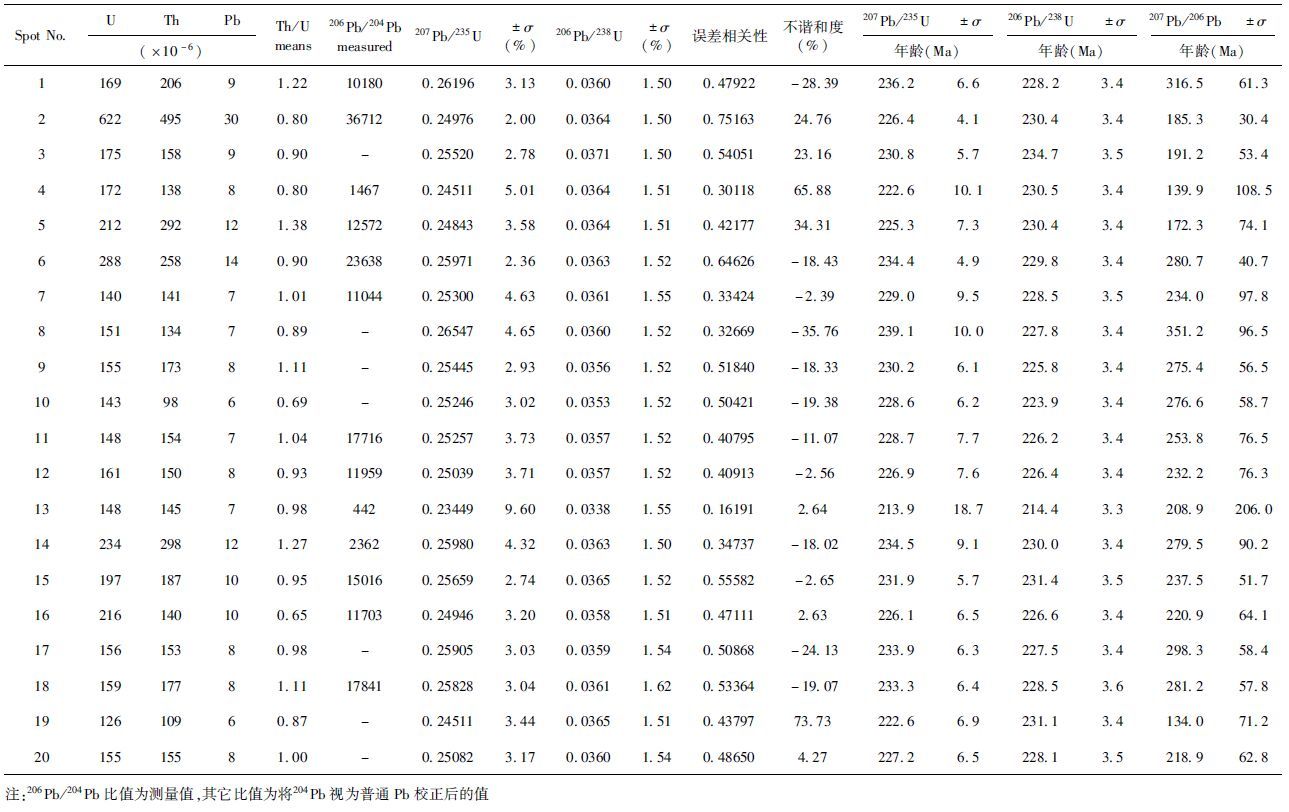
样品2011NK1024-8为黑云母正长岩。锆石多为棱柱状,分选出多都呈碎片状,均大于~100μm粒径,可能是分选过程中碎裂。锆石多发育清晰韵律环带,环带窄而密集(图 4)。锆石U、Th和Pb含量分别为126×10-6~622×10-6、98×10-6~495×10-6和6×10⁻⁶~30×10-6,Th/U比为0.65~1.38(表 1)。20个数据点的206Pb/238U表面年龄为214.4~234.7Ma,比较集中(表 1)。所有点的谐和度均在95%以上。计算得到19个数据点(20个数据点去掉1个13号点)206Pb/238U加权平均年龄为228.7±1.5Ma,MSWD=0.53(图 4);这19个点的谐和年龄为228.7±0.8Ma,MSWD=0.11,与平均年龄一致(图 4)。锆石具有典型岩浆锆石特征,岩石为岩浆岩,确定~229Ma的年龄代表结晶时代。

|
图 4 江北黑云母正长岩U-Pb年龄谐和图 插图示代表性锆石阴极发光照片 Fig. 4 U-Pb concordia diagram for the Kangbuk biotite-syenite |
德达岩体主体为黑云母/辉石正长岩,我们之前报道了黑云母正长岩和辉石岩的数据(Peng et al.,2008),本次补充采集了辉石正长岩和黑云母辉石岩样品。全岩标准矿物QAP和岩石化学图解均显示其为碱性岩类(图 5a,b)。总体而言,黑云母正长岩样品SiO2含量(~60%)、Al2O3含量(~22%)和K2O含量较高,K2O/Na2O达到77,但是Fe2O3T(全铁)含量(ca.1%~2%)、MgO含量(<0.5%)和稀土含量较低(稀土重量<100×10-6),微量元素含量大部分较低,少数元素如Rb含量(>1000×10-6)较高;与之相比,黑云母辉石岩、辉石正长岩以及辉石岩元素含量接近,样品SiO2含量(ca.40%~50%)、Al2O3含量(6.7%~10.8%)较低,K2O含量为3%~6 %,K2O/Na2O为3~9,Fe2O3T含量(9%~15%)、MgO含量(8%~12%)、稀土含量(稀土重量<360×10-6)和大部分微量元素含量较高,Rb含量低(<240×10-6)(图 6;表 2)。所有样品稀土和微量元素配分型式接近,均表现为轻稀土富集((La/Yb)N=27~156) ,Eu异常有一定变化(Eu*=0.8~1.85) ,高场强元素(Nb、Ta、Zr、Hf和Ti等)亏损,大离子亲石元素富集等特点(图 7)。

|
图 5 矿物QAP分类图(a,岩石中矿物含量为CIPW标准矿物)、硅碱图(SiO2-K2O+Na2O相关图)(b)和SiO2-(La/Yb)N相关图解(c) 南和北亚带数据来自Paek et al.(1996) ,Peng et al.(2008) ,Yang et al.(2010) ,Oh et al.(2006) ,William et al.(2009) ,Kim et al.(2011a,b),Seo et al.(2010) ,Cho et al.(2008) ,Yi et al.(2012) 及本研究 Fig. 5 QAP classification diagram based on CIPW norms calculated from the whole-rock compositions(a),Silicate vs. alkaline diagram(SiO2 vs. K2O+Na2O)(b)and SiO2 vs.(La/Yb)N diagram(c) |

|
图 6 代表性样品部分主量、微量元素与SiO2含量相关图解 数据来源同图 5 Fig. 6 Co-variation plots between selected major and trace elements and SiO2 for representative samples |

|
图 7 球粒陨石标准化稀土元素配分图(a)和原始地幔标准化微量元素蛛网图(b)(标准化值据Sun and McDonough,1989) 南亚带数据来源同图 5 Fig. 7 Chondrite-normalized trace element diagram(a)and primitive mantle-normalized trace element spidergram(b)(normalization values after Sun and McDonough,1989) |
江北里岩体内部成分变化较小,全岩标准矿物QAP和岩石化学图解均显示其为碱性岩类(图 5a,b)。其SiO2含量为55%~58%、TiO2含量~1%、Al2O3为13%~16%、Fe2O3T为5.8%~7.2%、MgO为3.6%~4.9%、CaO为3.7%~5.1%、Na2O为2.6%~3.6%、K2O为5%~6%、P2O5为1.2%~1.5%、Sr为945×10-6~1520×10-6、Ba为2135×10-6~4224×10-6、U为1.6×10⁻⁶~2.9×10⁻⁶、Zr为280×10-6~355×10-6、La为88×10-6~140×10-6、Y为19×10-6~28×10-6、Cr为116×10-6~230×10-6、Ni为42×10-6~58×10-6(图 6、表 2)。总稀土元素含量390×10-6~580×10-6,球粒陨石标准化稀土元素配分图上,显示明显的轻稀土富集((La/Yb)N=35~57) ,Eu中度负异常(Eu*=0.6~1.1) (图 6);原始地幔标准化微量元素蛛网图上,样品显示高场强元素负异常(Nb、Ta、Ti负异常较明显,Zr和Hf较弱)(图 7)。
6 讨论 6.1 德达和江北碱性岩岩浆来源和岩浆分异研究表明,正长岩可能来自地壳物质的部分熔融(Lubala et al.,1994),也可来自地幔源区(杨进辉等,2007;Laporte et al.,2014;Litvinovsky et al.,2015)。德达岩体中辉石正长岩和辉石岩中辉石自形,颗粒较大,其K2O+Na2O含量~14%(表 2);且极富K,其K2O/Na2O为42~77。Peng et al.(2008) 根据其成分判断为堆晶岩;同时,根据辉石Mg#值反算与之平衡的岩浆Mg#约65,从而推测其可能来源于地幔物质部分熔融;根据其富集轻稀土和大离子亲石元素的特点(图 7)判断其来自富集的岩石圈地幔。主体黑云母/辉石正长岩的MgO含量(<0.5%)和Fe2O3T含量(1%~2.4%)非常低,而含辉石成分不等的辉石正长岩-辉石岩却含量很高(MgO:8%~12%; Fe2O3T:9%~15%),Mg#值也较高(>60) ,考虑到堆晶岩中的实际矿物为辉石、黑云母和磷灰石,同时堆晶岩被碱性岩主体——黑云母/辉石/角闪石正长岩捕掳和穿切,推测辉石-黑云母-磷灰石的分离在岩浆分异过程中起着控制作用。同时,考虑到最晚期岩相为石英斑岩脉体(图 2b),不排除岩浆分异过程中存在混染的可能。
江北正长岩岩相较为单一,主体为含角闪石辉石黑云母正长岩,其成分分异较弱。与德达岩体主体相比,SiO2含量接近(55%~58%;德达岩体59~60%),但该岩体K2O+Na2O含量(~9%)和K2O/Na2O(1.4~2) 明显较低,而MgO(3.6%~4.9%)、Fe2O3 T(5.8%~7.2%)、TiO2(~1%)、P2O5(1.2%~1.5%)、CaO(3.7%~5.1%)等的含量明显较高(图 6);其稀土元素及其他微量元素总体配分特点与德达岩体中的辉石正长岩-辉石岩相似;不过,在稀土元素配分图解上,轻稀土分异稍强于德达岩体((La/Yb)N=35~57;德达岩体辉石正长岩为~27) ;在微量元素蛛网图上,其高场强元素(Nb、Ta、Zr和Hf)负异常明显比德达岩体要弱。综合分析,我们认为,其源区可能与德达岩体类似,但原岩部分熔融程度稍低,地壳混染程度较弱。鉴于江北正长岩岩体岩相较为单一,成分分异较弱,仅表现为局部的成分析离(图 3c),我们认为,分离结晶作用可能较弱。
6.2 朝鲜半岛三叠纪岩浆岩空间分布与成分变化及其构造意义图 1统计了朝鲜半岛已经发表的三叠纪岩浆岩数据,可以看出,这些岩浆岩主要分布在朝鲜半岛中南部(朝鲜南部、韩国中北部)。从岩性系列上看,朝鲜分布的岩体多为碱性岩,而且从北至南K2O/Na2O大致降低(Paek et al.,1996),德达岩体及靠北邻近区域的同时期金伯利岩(Yang et al.,2010),可以视为这个碱性岩带的起点(Peng et al.,2008)。韩国的岩体多以(纹长)二长岩为主,北部有少量碱性岩(如洪城地区,Seo et al.,2010),南部有少量A型花岗岩(如Daegang岩体,Cho et al.,2008),部分纹长二长岩大多有闪长岩-辉长岩端元(Kim et al.,2014)。图 1给出了根据岩石类型大致划分出的朝鲜半岛中部两类三叠纪岩浆岩,北部以碱性系列正长岩为主(本文称为北亚带/正长岩带/碱性岩带),岩性包括正长岩-碱长正长岩-石英正长岩及少量二长正长岩;南部则以亚碱性系列(纹长)二长岩为主(本文称为南亚带/二长岩带),岩性包括二长岩-二长闪长岩-石英二长岩-二长花岗岩-正长花岗岩等(图 5a),二者以洪城-高城一线为界(图 1)。图 5、图 6给出了两个亚带部分地球化学数据,可以看出,与南亚带岩体相比,北亚带岩体SiO2和Na2O等的含量整体上略低,而K2O、Sr、Ba、La、Eu、Y、Cr等及稀土元素含量整体上略高,轻重稀土分异程度略高。
图 8示以这一界线为起点,根据各个岩体到界线的距离所作的距离与一些元素含量或比值变化相关图解。大致可以看出,空间上,K2O/Na2O和SiO2有相反的变化,即两个亚带内从南向北,K2O/Na2O逐渐升高,而SiO2含量则相反,逐渐降低(图 8);K2O+Na2O和Sr/Y的变化是相近的,即南亚带从南向北,北亚带从北向南,两者逐渐降低(图 8)。

|
图 8 南北两个亚带不同岩体K2O/Na2O、K2O+Na2O、SiO2和Sr/Y等空间上的变化 距离指岩体与两个亚带分界线最短距离.堆晶岩没有投图 Fig. 8 Spatial variations of K2O/Na2O,K2O+Na2O,SiO2 and Sr/Y values of different plutons/complexes in the north and south subzones |
前人在研究地中海新生代火山岩时提出,K2O/Na2O值的变化可能与俯冲极性有关(Stern et al.,1993; Savelli,2000);Liu et al.(2016) 则在研究中国东北钾质玄武岩时,提出岩石中K2O/Na2O值的变化与岩石圈的厚度直接相关,K2O/Na2O高,岩石圈厚度大。这是考虑到岩石圈厚度越厚,岩浆向上运移过程中,金云母结晶析出导致的K降低越明显,这将导致侵位到地壳中的岩体K/Na比值降低。我们认为,对于北亚带(正长岩系列),由于这些岩浆岩来自幔源,K2O/Na2O的变化也许可以通过岩石圈厚度的不同来解释(图 9);而K2O+Na2O与SiO2含量的高低与源区部分熔融程度有关,K2O+Na2O含量越高(SiO2含量越低)表明源区部分熔融程度越低(以金云母等富碱质矿物部分熔融为主);Sr/Y的变化可能与源区长石和单斜辉石参与部分熔融程度有关,Sr/Y高,说明源区长石和单斜辉石部分熔融程度高。

|
图 9 朝鲜半岛三叠纪岩浆岩成因及构造背景假想图 Fig. 9 A hypothesis cartoon showing the genesis and tectonic environments of the Triassic plutons in Korean Peninsula |
南亚带(二长岩带)的成分变化可能更多受控于壳源岩浆岩的贡献,其中,靠近洪城地区的岩体,可能还有幔源岩浆的贡献(SiO2平均含量低,图 8)。大部分岩体K2O/Na2O、K2O+Na2O及SiO2反映地壳母岩的部分熔融程度:部分熔融程度低,镁铁质矿物残留多,K2O+Na2O和SiO2含量高;转熔反应生成的黑云母多,K2O/Na2O值低。Sr/Y的变化可能反映压力变化(Defant and Drummond,1990),Sr/Y值高,发生部分熔融地壳岩石的压力高。
综合前人资料,可以得出:1) 南部和北部亚带岩浆岩都与朝鲜半岛中部洪城地区的退变榴辉岩(变质时代~230Ma,如Oh et al.,2006)近似同期,且两个亚带的分界线大致与退变榴辉岩的出露区域重叠,并与Oh et al.(2006) 提出的洪城-五台山缝合带以及Kim et al.(2011a)提出的洪城-元山缝合带大致重叠,说明这些事件很可能是同成因的;2) 南北两个亚带基底岩石系列存在差异(彭澎等,2016);3) 南北两个亚带岩浆岩形成的构造背景与华北(朝鲜半岛北部)与华南(朝鲜半岛南部)两个陆块的碰撞有关(Ernst et al.,2007;Peng et al.,2008;Oh et al.,2009;Kim et al.,2011a,b)。我们推测,南北两个亚带可能分属不同的构造单元,分别属于华北陆块和华南陆块(图 9);区域上岩性的差异(图 1)和岩石化学成分的变化(图 5、图 6、图 8)可能与岩石圈的厚度有关;两个亚带之间的界线接近缝合线。朝鲜半岛南部(华南陆块)地壳被拖拽俯冲到朝鲜半岛北部(华北陆块)之下,朝鲜半岛中部缝合带两侧岩石圈结构出现差异,导致区域上差异性形成三叠纪不同类型的岩浆岩(图 9):北亚带(正长岩带)的岩浆岩主要受控于岩石圈的厚度及地幔源区的深度;南亚带(二长岩)主要受控于地壳熔融部位的深度(压力)及部分熔融程度。这与我们课题组构造解析的模式是一致的(武昱东和侯泉林,2016)。
7 结论综合我们获得的以及已经发表的朝鲜半岛中部三叠纪岩浆岩数据,初步得出如下结论:
(1) 江北岩体中主体岩相黑云母正长岩的锆石U-Pb谐和年龄为228.7±0.8Ma,说明这一岩体形成于三叠纪晚期;
(2) 江北岩体主体为黑云母正长岩,与德达岩体相比,成分较为单一,K2O/Na2O、(La/Yb)N值较小,高场强元素亏损较弱,但微量元素配分型式基本一致。与德达碱性岩体相似,江北正长岩可能来源于富集的岩石圈地幔。
(3) 朝鲜半岛中部三叠纪岩浆岩分布于一个北东向走廊地带,以洪城-高城为界可以分为两个亚带,北亚带以正长岩为主,南亚带以(纹长)二长岩为主,主体形成于ca.230~220Ma,与本区高级变质作用基本同期,分布范围大致对应(稍大),说明它们是同成因的。
(4) 朝鲜半岛中部三叠纪岩浆岩带南北亚带岩石均显示高场强元素亏损,轻稀土元素和大离子亲石元素富集的典型大陆岩石圈地球化学特征;但也存在空间差异,如,两个亚带内从南向北,K2O/Na2O逐渐升高,SiO2含量逐渐降低;南亚带从南向北,北亚带从北向南,K2O+Na2O和Sr/Y均逐渐降低。我们认为,这些岩浆岩属于同碰撞-碰撞后岩浆产物,两个亚带之间的界线可能接近华北和华南古陆的基底缝合带,有关成分的变化受控于华南古陆向华北古陆之下俯冲形成的特定壳幔结构。
致谢 本文是翟明国研究员带领的中国科学院地质与地球物理研究所中朝地质对比研究团队集体成果。除署名作者外,翟明国研究员、吴福元研究员、侯泉林教授、李秋立研究员、张晓晖研究员、刘富博士以及赵磊博士参加了野外工作,对本文有实质贡献。感谢朝鲜国家科学院地质学研究所给予的帮助。感谢韩国吴昌桓教授、崔善奎教授、柳寅昌教授等的帮助。感谢薛丁帅、刘艳红、李潮峰、刘宇、唐国强、王冲等在实验过程中的帮助。感谢蔡剑辉教授等的修改意见。| [1] | Cai QZ. 1995. Corresponding division of geotectonic units of eastern China and Korea. Marine Geology & Quaternary Geology , 15 (1) :7–24. |
| [2] | Chang KH and Park SO. 2001. Paleozoic Yellow Sea Transform Fault:Its role in the tectonic history of Korea and adjacent regions. Gondwana Research , 4 (4) :588–589. |
| [3] | Chang KH. 2015. Yellow Sea Transform Fault (YSTF) and the developemnt of Korean Peninsula. Russian Journal of Pacific Geology , 9 (2) :81–95. DOI:10.1134/S1819714015020037 |
| [4] | Cho DL, Lee SR and Armstrong R. 2008. Termination of the Permo-Triassic Songrim (Indosinian) orogeny in the Ogcheon belt, South Korea:Occurrence of ca. 220Ma post-orogenic alkali granites and their tectonic implications. Lithos , 105 (3-4) :191–200. |
| [5] | Chough SK, Kwon ST, Ree JH and Choi DK. 2000. Tectonic and sedimentary evolution of the Korean peninsula:A review and new view. Earth-Science Reviews , 52 (1-3) :175–235. DOI:10.1016/S0012-8252(00)00029-5 |
| [6] | Ernst WG and Liou JG. 1995. Contrasting plate-tectonic styles of the Qinling-Dabie-Sulu and Franciscan metamorphic belts. Geology , 23 (4) :353–356. DOI:10.1130/0091-7613(1995)023<0353:CPTSOT>2.3.CO;2 |
| [7] | Ernst WG, Tsujimori T, Zhang R and Liou JG. 2007. Permo-Triassic collision, subduction-zone metamorphism, and tectonic exhumation along the East Asian continental margin. Annual Review of Earth and Planetary Sciences , 35 (1) :73–110. DOI:10.1146/annurev.earth.35.031306.140146 |
| [8] | Hong TK and Choi H. 2012. Seismological constraints on the collision belt between the North and South China blocks in the Yellow Sea. Tectonophysics , 570-571 :102–113. DOI:10.1016/j.tecto.2012.08.034 |
| [9] | Hou QL, Wu YD, Wu FY, Zhai MG, Guo JH and Li Z. 2008. Possible tectonic manifestations of the Dabie-Sulu orogenic belt on the Korean Peninsula. Geological Bulletin of China , 27 (10) :1659–1666. |
| [10] | Ishiwatari A and Tsujimori T. 2003. Paleozoic ophiolites and blueschists in Japan and Russian Primorye in the tectonic framework of East Asia:A synthesis. Island Arc , 12 (2) :190–206. DOI:10.1046/j.1440-1738.2003.00390.x |
| [11] | Kim SW, Kwon S, Koh HJ, Yi K, Jeong YJ and Santosh M. 2011a. Geotectonic framework of Permo-Triassic magmatism within the Korean Peninsula. Gondwana Research , 20 (4) :865–889. DOI:10.1016/j.gr.2011.05.005 |
| [12] | Kim SW, Kwon S, Santosh M, Williams IS and Yi K. 2011b. A Paleozoic subduction complex in Korea:SHRIMP zircon U-Pb ages and tectonic implications. Gondwana Research , 20 (4) :890–903. DOI:10.1016/j.gr.2011.05.004 |
| [13] | Kim SW, Kwon SH, Yi K and Santosh M. 2014. Arc magmatism in the Yeongnam massif, Korean Peninsula:Imprints of Columbia and Rodinia supercontinents. Gondwana Research , 26 (3-4) :1009–1027. DOI:10.1016/j.gr.2013.08.020 |
| [14] | Kwon S, Sajeev K, Mitra G, Park Y, Kim SW and Ryu IC. 2009. Evidence for Permo-Triassic collision in Far East Asia:The Korean collisional orogen. Earth and Planetary Science Letters , 279 (3-4) :340–349. DOI:10.1016/j.epsl.2009.01.016 |
| [15] | Laporte D, Lambart S, Schiano P and Ottolini L. 2014. Experimental derivation of nepheline syenite and phonolite liquids by partial melting of upper mantle peridotites. Earth and Planetary Science Letters , 404 :319–331. DOI:10.1016/j.epsl.2014.08.002 |
| [16] | Lee BC, Oh CW, Kim TS and Yi K. 2016. The metamorphic evolution from ultrahigh-temperature to amphibolite facies metamorphism in the Odaesan area after the collision between the North and South China cratons in the Korean Peninsula. Lithos , 256-257 :109–131. DOI:10.1016/j.lithos.2016.03.019 |
| [17] | Lee YI and Lee JI. 2003. Paleozoic sedimentation and tectonics in Korea:A review. Island Arc , 12 (2) :162–179. DOI:10.1046/j.1440-1738.2003.00388.x |
| [18] | Litvinovsky BA, Jahn BM and Eyal M. 2015. Mantle-derived sources of syenites from the A-type igneous suites:New approach to the provenance of alkaline silicic magmas. Lithos , 232 :242–265. DOI:10.1016/j.lithos.2015.06.008 |
| [19] | Liu JQ, Chen LH, Zeng G, Wang XJ, Zhong Y and Yu X. 2016. Lithospheric thickness controlled compositional variations in potassic basalts of Northeast China by melt-rock interactions. Geophysical Research Letters , 43 (6) :2582–2589. DOI:10.1002/2016GL068332 |
| [20] | Lubala RT, Frick C, Rogers JH and Walraven F. 1994. Petrogenesis of syenites and granites of the Schiel Alkaline complex, Northern Transvaal, South Africa. The Journal of Geology , 102 (3) :307–316. DOI:10.1086/629673 |
| [21] | Metcalfe I. 2006. Palaeozoic and Mesozoic tectonic evolution and palaeogeography of East Asian crustal fragments:The Korean Peninsula in context. Gondwana Research , 9 (1-2) :24–46. DOI:10.1016/j.gr.2005.04.002 |
| [22] | Niu YL, Liu Y, Xue QQ, Shao FL, Chen S, Duan M, Guo PY, Gong HM, Hu Y, Hu ZX, Kong JJ, Li JY, Liu JJ, Sun P, Sun WL, Ye L, Xiao YY and Zhang Y. 2015. Exotic origin of the Chinese continental shelf:New insights into the tectonic evolution of the Western Pacific and eastern China since the Mesozoic. Science Bulletin , 60 (18) :1598–1616. DOI:10.1007/s11434-015-0891-z |
| [23] | Oh CW, Kim SW and Williams IS. 2006. Spinel granulite in Odesan area, South Korea:Tectonic implications for the collision between the North and South China blocks. Lithos , 92 (3-4) :557–575. DOI:10.1016/j.lithos.2006.03.051 |
| [24] | Oh CW and Kusky T. 2007. The Late Permian to Triassic Hongseong-Odesan collision belt in South Korea, and its tectonic correlation with China and Japan. International Geology Review , 49 (7) :636–657. DOI:10.2747/0020-6814.49.7.636 |
| [25] | Oh CW, Choi SG, Seo J, Rajesh VJ, Lee JH, Zhai M and Peng P. 2009. Neoproterozoic tectonic evolution of the Hongseong area, southwestern Gyeonggi Massif, South Korea:Implication for the tectonic evolution of Northeast Asia. Gondwana Research , 6 :272–284. |
| [26] | Oh CW. 2012. The tectonic evolution of South Korea and Northeast Asia from Paleoproterozoic to Triassic. The Journal of the Petrological Society of Korea , 21 (2) :59–87. DOI:10.7854/JPSK.2012.21.2.059 |
| [27] | Oh CW, Imayama T, Lee SY, Yi SB, Yi K and Lee BC. 2015. Permo-Triassic and Paleoproterozoic metamorphism related to continental collision in Yangpyeong, South Korea. Lithos , 216-217 :264–284. DOI:10.1016/j.lithos.2014.12.016 |
| [28] | Paek RJ, Kang HG and Jon GP.1996. Geology of Korea. Pyongyang: Foreign Languages Books Publishing House : 1 -631. |
| [29] | Peng P, Zhai MG, Guo JH, Zhang HF and Zhang YB. 2008. Petrogenesis of Triassic post-collisional syenite plutons in the Sino-Korean craton:An example from North Korea. Geological Magazine , 145 (5) :637–647. |
| [30] | Peng P, Wang C, Yang JH and Kim JN. 2016. A preliminary study on the rock series and tectonic environment of the~1. 9Ga plutonic rocks in Korea. Acta Petrologica Sinica , 32 (10) :2993–3018. |
| [31] | Ree JH, Cho M, Kwon ST and Nakamura E. 1996. Possible eastward extension of Chinese collision belt in South Korea:The Imjingang belt. Geology , 24 (12) :1071–1074. DOI:10.1130/0091-7613(1996)024<1071:PEEOCC>2.3.CO;2 |
| [32] | Ren JS. 2003. A brief introduction of the latest tectonic map of China. Acta Geoscientia Sinica , 24 (1) :1–2. |
| [33] | Sagong H, Kwon ST and Ree JH. 2005. Mesozoic episodic magmatism in South Korea and its tectonic implication. Tectonics , 24 (5) :TC5002. DOI:10.1029/2004TC001720 |
| [34] | Sajeev K, Jeong J, Kwon S, Kee WS, Kim SW, Komiya T, Itaya T, Jung HS and Park Y. 2010. High P-T granulite relicts from the Imjingang belt, South Korea:Tectonic significance. Gondwana Research , 17 (1) :75–86. DOI:10.1016/j.gr.2009.07.001 |
| [35] | Savelli C. 2000. Subduction-related episodes of K-alkaline magmatism (15~0. 1Ma) and geodynamic implications in the north Tyrrhenian-central Italy region:A review. Journal of Geodynamics , 30 (5) :575–591. |
| [36] | Seo J, Choi SG and Oh CW. 2010. Petrology, geochemistry, and geochronology of the post-collisional Triassic mangerite and syenite in the Gwangcheon area, Hongseong Belt, South Korea. Gondwana Research , 18 (2-3) :479–496. DOI:10.1016/j.gr.2009.12.009 |
| [37] | Stacey JS and Kramers JD. 1975. Approximation of terrestrial lead isotope evolution by a two-stage model. Earth and Planetary Science Letters , 26 (2) :207–221. DOI:10.1016/0012-821X(75)90088-6 |
| [38] | Stern RJ, Jackson MC, Fryer P and Ito E. 1993. O, Sr, Nd, and Pb isotopic composition of Kasuga Cross-Chain in the Mariana arc:A new perspective on the K-h relationship. Earth and Planetary Science Letters , 119 (4) :459–475. DOI:10.1016/0012-821X(93)90056-F |
| [39] | Sun SS and McDonough WF. 1989. Chemical and isotopic systematics of oceanic basalts:Implications for mantle composition and processes. In:Saunders AD and Norry MJ (eds.). Magmatism in the Ocean Basins. Geological Society, London. Special Publications , 42 (1) :313–345. DOI:10.1144/GSL.SP.1989.042.01.19 |
| [40] | Suzuki K. 2009. CHIME dating and age mapping of monazite in granulites and paragneisses from the Hwacheon area, Korea:Implications for correlations with Chinese cratons. Geosciences Journal , 13 (3) :275–292. DOI:10.1007/s12303-009-0027-z |
| [41] | Tang XJ, Yu WH and Shan R. 2010. The mesozoic plate boundary in the Eastern China and Korean Peninsula:Present studies and problems. Acta Geologica Sinica , 84 (5) :606–617. |
| [42] | Uno K. 2000. Clockwise rotation of the Korean Peninsula with respect to the North China Block inferred from an improved Early Triassic palaeomagnetic pole for the Ryeongnam Block. Geophysical Journal International , 143 (3) :969–976. DOI:10.1046/j.0956-540X.2000.01289.x |
| [43] | Williams IS, Cho DL and Kim SW. 2009. Geochronology, and geochemical and Nd-Sr isotopic characteristics, of Triassic plutonic rocks in the Gyeonggi Massif, South Korea:Constraints on Triassic post-collisional magmatism. Lithos , 107 (3-4) :239–256. DOI:10.1016/j.lithos.2008.10.017 |
| [44] | Wu FY, Han RH, Yang JH, Wilde SA, Zhai MG and Park SC. 2007. Initial constraints on the timing of granitic magmatism in North Korea using U-Pb zircon geochronology. Chemical Geology , 238 (3-4) :232–248. DOI:10.1016/j.chemgeo.2006.11.012 |
| [45] | Wu YD and Hou QL. 2016. The extension of the Dabie-Sulu orogenic belt in Korean Peninsula:Base on 40Ar/39Ar Tectonic chronology. Acta Petrologica Sinica , 32 (10) :3187–3204. |
| [46] | Xu JW and Zhu G. 1995. Discussion on tectonic models for the Tan-Lu Fault Zone, eastern China. Journal of Geology & Mineral Resources North China , 10 (2) :121–134. |
| [47] | Yang JH, Wu FY, Xie LW and Liu XM. 2007. Petrogenesis and tectonic implications of Kuangdonggou syenites in the Liaodong Peninsula, east North China Croton:Constraints from in-situ zircon U-Pb ages and Hf isotopes. Acta Petrologica Sinica , 23 (2) :263–276. |
| [48] | Yang JH, O'Reilly S, Walker RJ, Griffin W, Wu FY, Zhang M and Pearson N. 2010. Diachronous decratonization of the Sino-Korean craton:Geochemistry of mantle xenoliths from North Korea. Geology , 38 (9) :799–802. DOI:10.1130/G30944.1 |
| [49] | Yi K, Cheong CS, Kim J, Kim N, Jeong YJ and Cho M. 2012. Late Paleozoic to Early Mesozoic arc-related magmatism in southeastern Korea:SHRIMP zircon geochronology and geochemistry. Lithos , 153 :129–141. DOI:10.1016/j.lithos.2012.02.007 |
| [50] | Yin A and Nie SY. 1993. An indentation model for the North and South China collision and the development of the Tan-Lu and Honam fault systems, eastern Asia. Tectonics , 12 (4) :801–813. DOI:10.1029/93TC00313 |
| [51] | Yue BJ, Liao J, Liu H, Zeng J and Shi J. 2014. East boundary of the collision belt between Sino-Korean and Yangtze plates in eastern China and their extension in the sea. Marine Geology & Quaternary Geology , 34 (1) :75–85. |
| [52] | Zhai MG, Guo JH, Li Z, Chen DZ, Peng P, Li TS, Hou QL and Fan QC. 2007. Linking the Sulu UHP belt to the Korean Peninsula:Evidence from eclogite, Precambrian basement, and Paleozoic sedimentary basins. Gondwana Research , 12 (4) :388–403. DOI:10.1016/j.gr.2007.02.003 |
| [53] | Zhai MG. 2016. Comparative study of geology in North China and Korean Peninsula:Research advances and key issues. Acta Petrologica Sinica , 32 (10) :2915–2932. |
| [54] | Zhang YB, Wu FY, Yang JH, Kim JN and Han RY. 2016. Petrogenesis and geological implications of Phanerozoic granitoids at northern Korean Peninsula. Acta Petrologica Sinica , 32 (10) :3098–3122. |
| [55] | Zhao L, Zhang YB, Yang JH, Han RY and Kim JN. 2016. Paleoproterozoic high temperature metamorphism and anatexis in the northwestern Korean Peninsula:Constraints from petrology and zircon U-Pb geochronology. Acta Petrologica Sinica , 32 (10) :3045–3069. |
| [56] | 蔡乾忠.1995. 中国东部与朝鲜大地构造单元对应划分. 海洋地质与第四纪地质 , 15 (1) :7–24. |
| [57] | 侯泉林, 武昱东, 吴福元, 翟明国, 郭敬辉, 李忠.2008. 大别-苏鲁造山带在朝鲜半岛可能的构造表现. 地质通报 , 27 (10) :1659–1666. |
| [58] | 彭澎, 王冲, 杨正赫, 金正男.2016. 朝鲜~19亿年侵入岩的岩石类型与构造背景初探. 岩石学报 , 32 (10) :2993–3018. |
| [59] | 任纪舜.2003. 新一代中国大地构造图——中国及邻区大地构造图(1:5000000)附简要说明:从全球看中国大地构造. 地球学报 , 24 (1) :1–2. |
| [60] | 唐贤君, 於文辉, 单蕊.2010. 中国东部-朝鲜半岛中生代板块结合带划分研究现状与问题. 地质学报 , 84 (5) :606–617. |
| [61] | 武昱东, 侯泉林.2016. 大别-苏鲁造山带在朝鲜半岛的延伸方式——基于40Ar/39Ar构造年代学的约束. 岩石学报 , 32 (10) :3187–3204. |
| [62] | 徐嘉炜, 朱光.1995. 中国东部郯庐断裂带构造模式讨论. 华北地质矿产杂志 , 10 (2) :121–134. |
| [63] | 杨进辉, 吴福元, 谢烈文, 柳小明.2007. 辽东矿洞沟正长岩成因及其构造意义:锆石原位微区U-Pb年龄和Hf同位素制约. 岩石学报 , 23 (2) :263–276. |
| [64] | 岳保静, 廖晶, 刘鸿, 曾洁, 施剑.2014. 中朝-扬子板块碰撞结合带东部边界及海域延伸. 海洋地质与第四纪地质 , 34 (1) :75–85. |
| [65] | 翟明国.2016. 朝鲜半岛与华北地质之对比研究:进展与问题. 岩石学报 , 32 (10) :2915–2932. |
| [66] | 张艳斌, 吴福元, 杨正赫, 金正男, 韩龙渊.2016. 朝鲜半岛北部显生宙花岗岩成因研究及地质意义. 岩石学报 , 32 (10) :3098–3122. |
| [67] | 赵磊, 张艳斌, 杨正赫, 韩龙渊, 金正男.2016. 朝鲜半岛西北部古元古代高温变质-深熔作用:宏观和微观岩石学以及锆石U-Pb年代学制约. 岩石学报 , 32 (10) :3045–3069. |