
|
收稿日期: 2018-03-14; 预印本: 2018-05-31
基金项目: 国家重点研发计划(编号:2017YFB0504000,2017YFB0504001);国家自然科学基金(编号:41601393);高分辨率对地观测系统重大专项(民用部分)项目(编号:32-Y20A17-9001-15/17)
第一作者简介: 吴浩,1991年生,男,博士研究生,研究方向为大气CO2反演。E-mail:wuhaoahnu@163.com
通信作者简介: 王先华,1963年生,男,研究员,研究方向为大气CO2反演。E-mail:xhwang@aiofm.ac.cn
|
摘要
大气温室气体监测仪GMI(Greenhouse gases Monitor Instrument)是高分五号(GF-5)卫星载荷之一,主要用于全球温室气体含量监测和碳循环研究。高精度反演是卫星大气CO2遥感的基本需求。地表反射率影响卫星遥感辐射量及辐射传输过程中的地气耦合过程,严重制约着CO2的反演精度,针对GMI开发高精度的大气CO2反演算法,地表反射是一个需要重点考虑的因素。城市是CO2重要的发射源,且城市下垫面存在明显的二向反射特性,加上城市大气条件不良,复杂的地气耦合效应存在这都考验反演算法的准确性和鲁棒性。本文针对北京城市地区,利用2011年—2016年共5年的MODIS(MODerate-resolution Imaging Spectroradiometer)地表二向反射分布函数BRDF(Bidirectional Reflectance Distribution Function)数据,构建了适合利用单次观测数据反演的BRDF模型,并提出一种同时反演地表BRDF参数和大气CO2含量的算法。结果表明在550 nm波长处气溶胶光学厚度AOD(Aerosol Optical Depth)小于0.4时,大部分GMI模拟数据的反演误差控制在0.5%(~2 ppm)内。利用GOSAT (Greenhouse gases Observing SATellite)实测数据的反演结果与修正后的日本国立环境研究所NIES(National Institute for Environmental Studies)反演结果进行对比,其平均误差为1.25 ppm,相关性达到0.85。本算法满足GMI数据在北京城市区域高精度CO2反演的需求,并使得反演高值气溶胶区域数据成为可能,增加了GMI观测数据的利用率。
关键词
高分五号, GMI, CO2反演, BRDF, 气溶胶
Abstract
The greenhouse Gas Monitor Instrument (GMI) is a payload of GF-5 satellite. It is mainly used to ascertain the global distribution of carbon dioxide (CO2) and methane (CH4) and carbon cycling studies. Surface reflection is an important factor for developing a high-precision column-averaged carbon dioxide dry air mole fraction (XCO2) retrieval algorithm for the GMI short-wave infrared data. Urban areas are an important source of CO2 emission, and an apparent directional reflection occurs in the urban underlying surface. However, the aerosol optical depth (AOD 550 nm) in Urban Beijing is relatively large, and combining atmospheric scattering and surface directional reflection makes the retrieval of XCO2 in Beijing urban area difficult. In this study, we investigate the MODIS Bidirectional Reflectance Distribution Function (BRDF) data in Beijing urban area in 2011–2016. The three parameters (fiso, fgeo, and fvol) of the BRDF model vary with season. The ratio of fiso to fgeo and of fiso to fvol slightly change. Statistics show that the average value of fgeo/fiso is 0.42±0.09 and fvol/fiso is 0.23±0.03. The simplification of the BRDF model allows us to invert the BRDF parameters simultaneously through one observation of the GMI. We present a new algorithm to improve the accuracy of XCO2 in Beijing urban areas through simultaneous retrieval of BRDF parameters. An a priori value of AOD is provided by using a directional polarimetric camera, which is onboard the GF-5 satellite. The MODIS MCD43A1 product is used to build an a priori surface BRDF database after filtering and resampling. The a priori CO2 profile is estimated on the basis of the analysis of CO2 profile distribution in Beijing area. The monthly a priori covariance matrices of CO2 at a grid cell (2°×3°) on the globe is precalculated as input parameters using the carbon tracker database. The measurement error covariance matrix is (y/SNR)2, and the signal-to-noise ratio (SNR) used is the result of a laboratory test. This SNR is a tentative value and must be tuned after acquiring in-orbit data. To determine the effect of aerosols and surface BRDF reflection on the retrieval of XCO2, we simulate GMI measurements in the spectral range of 6310–6380 cm−1. We use absolute radiance, ratio radiance, and BRDF methods to retrieve the simulation data separately. The error of the absolute radiance method exceeds 30% when the AOD is 0.05 considering the changes in surface albedo caused by surface direction reflection, and the error of the ratio radiance method is less than 1% in most observations. By contrast, the BRDF method has high accuracy, and its error is less than 0.2%. In the case of high AOD (0.4), the maximum error of XCO2 is 4.75% without the inversion of BRDF parameters. The evaluated precisions of the retrieved XCO2 are less than 0.5% in most cases. To validate the correctness of our algorithm for the measured data, we retrieve the observations of the AOD less than 0.4 from Greenhouse Gases Observing Satellite (GOSAT) L2 data in Beijing urban area in 2016. We find that the correlation is 0.85, and the average error is 1.25 ppm by comparing our retrievals with GOSAT NIES XCO2. The retrievals are stable, except the results in summer. The AOD of 64.28% observations in summer is larger than 0.3, and the rest is close to 0.3. The difference in albedo caused by the BRDF characteristics of the urban underlying surface significantly influences the accuracy of XCO2 retrievals, and the high-precision CO2 concentration information cannot be obtained when it is not corrected. The aerosol conditions in urban areas are frequently complex. The proposed algorithm for the simultaneous retrieval of surface BRDF parameters and CO2 content can accurately describe the surface direction reflection. The proposed algorithm improves the retrieval accuracy and data utilization of GMI data in the urban areas of Beijing.
Key words
GF-5, GMI, CO2 retrieval, BRDF, aerosol
1 引 言
CO2是大气中主要的温室气体,科学家们普遍认为人为排放的CO2是全球变暖的关键因素(Myhrvold和Caldeira,2012)。世界各国陆续开展了监测大气CO2的研究,相比于地基观测,卫星监测手段具有更广的观测范围,可进行全球范围连续的CO2含量监测,目前在轨的有日本2009年发射的GOSAT卫星(Yokota 等,2009)、美国2014年发射的OCO-2卫星(Hammerling 等,2012)和中国2016年发射的Tansat卫星(Liu 等,2013),在未来2—4年内,还有中国科学院安徽光学精密机械研究所研制的GMI(Wu 等,2018)、日本国立环境研究所研制的GOSAT-2等多颗温室气体监测载荷入轨(Oishi 等,2017)。鉴于大气CO2遥感应用上的需求,对数据反演精度都有很高的要求,日本GOSAT的目标精度为3.8 ppm,美国的OCO-2的目标精度为1—2 ppm,中国GMI的目标精度也为3.8 ppm。高精度大气CO2反演过程中,对地表反射评估不足,会引起较大反演误差。Aben等(2007)利用模拟数据研究指出,当地表反射率从0.1变化到0.5时,反演CO2柱浓度最大会有–5%—5%的误差。O’Dell等(2012)指出,在反演陆地上空XCO2时,将地表假设为朗伯表面,在AOD大于0.25时会出现明显误差。叶函函等(2013)指出,不考虑地表二向反射特性,CO2柱浓度在反演过程中的平均误差为14.53%。城市地区是CO2重要的发射源,对其进行高精度的CO2含量监测有益于控制人为碳排放(Dhakal,2009)。精确反演城市CO2含量,目前的反演方法存在两点不足。一是城市下垫面具有明显的二向反射特性(Friedl 等,2002),将其假设为各向同性的朗伯体无法正确表征地表反射;二是城市大气环境较差,获得理想观测条件(AOD<0.3)的概率低,在高气溶胶值情况下,大气辐射地气耦合复杂。在城市中进行大气CO2的高精度反演,引入地表二向反射模型,有效地校正地表反射成为影响反演精度的关键。
2 基本原理
城市下垫面大气CO2反演算法流程图如图1所示。在反演大气CO2含量的过程中,引入城市BRDF模型。城市BRDF模型构建基于Ross-Li地表反射模型,该模型能够较好表征地表二向反射,同时属于核驱动模型反演方便(Shuai 等,2008)。Ross-Li模型的描述见式(1)
| $\begin{aligned} R({\theta _{\rm{s}}},{\theta _{\rm{v}}},\varphi ;\lambda) =& {f_{{\rm{iso}}}}(\lambda){k_{{\rm{iso}}}} + {f_{{\rm{geo}}}}(\lambda){k_{{\rm{geo}}}}({\theta _{\rm{s}}},{\theta _{\rm{v}}},\varphi) + \\& {f_{{\rm{vol}}}}(\lambda){k_{{\rm{vol}}}}({\theta _{\rm{s}}},{\theta _{\rm{v}}},\varphi) \\ \end{aligned}$ | (1) |
式中,
| $\begin{aligned} R({\theta _{\rm{s}}},{\theta _{\rm{v}}},\varphi) = &{f_{{\rm{iso}}}}({k_{{\rm{iso}}}} + f_{{\rm{geo}}}'{k_{{\rm{geo}}}}({\theta _{\rm{s}}},{\theta _{\rm{v}}},\varphi) + \\ & f_{{\rm{vol}}}'{k_{{\rm{vol}}}}({\theta _{\rm{s}}},{\theta _{\rm{v}}},\varphi)) \\ \end{aligned}$ | (2) |
如果式(2)中
| ${{y}} = F ({{x}},{{b}}) + \varepsilon $ | (3) |
式中,
| $\begin{split} J({{x}}) =& {({{y}} - F({{x}}))^{\rm{T}}}{{S}}_\varepsilon ^{ - 1}({{y}} - F({{x}})) + \\ & {({{x}} - {{{x}}_{\rm{a}}})^{\rm{T}}}{{S}}_{\rm{a}}^{ - 1}({{x}} - {{{x}}_{\rm{a}}}) \end{split}$ | (4) |
根据高斯迭代公式(5)求状态向量x的值,使得
| $ \begin{array}{l} {{x}_{\left( {i + 1} \right)}} = {{x}_i}+{\left( {{K}_i^{\rm{T}}{S}_\varepsilon ^{ { - 1} }{{K}_i} + \left( {1 + \gamma } \right){S}_{\rm{a}}^{ { - 1} }} \right)^{ { - 1} }}\\ \left( {{K}_i^{\rm{T}}{S}_\varepsilon ^{ { - 1} }\left( {{y} - F\left( {x} \right) - {S}_{\rm{a}}^{ { - 1} }\left( {{{x}_i} - {{x}_{\rm{a}}}} \right)} \right)} \right) \end{array} $ | (5) |
| ${{{K}}_i} = \partial F({{{x}}_i})/\partial {{{x}}_i}$ | (6) |
式中,
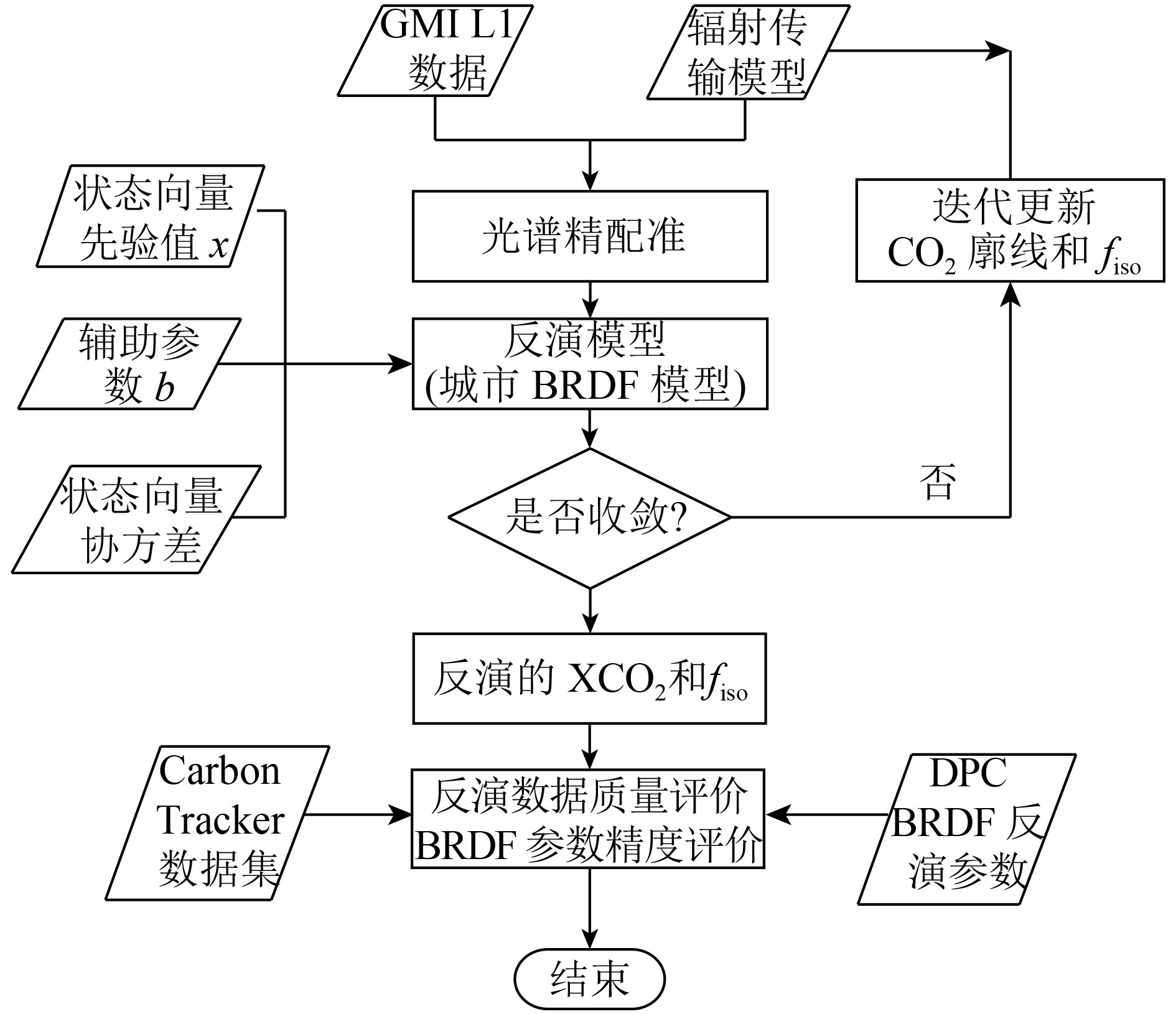

表 1 GMI数据反演过程中状态向量的先验值和协方差矩阵与辅助参数信息
Table 1 State vector, its a priori, the variance covariance matrix and auxiliary parameters for the GMI retrieval
|
|
|
|
| CO2/ppm | Carbon Tracker | Carbon Tracker(2°×3°) |
| AOD (550 nm) | DPC同步观测 | 1.02 |
|
|
MODIS数据库 | 1.02 |
|
|
来源 | 分辨率/ 层数 |
| 温度廓线 /K | ECMWFERA-Interim | 0.125°/ 46 |
| 水汽廓线 /ppm | ||
| 压力廓线 /hPa | ||
| 地表高程/km | SRTM | 90 m / 1 |
3 数据处理结果与分析
3.1 数据来源
GMI是GF-5卫星上的重要大气环境监测载荷之一,采用空间外差干涉技术进行高光谱分光,其主要任务是获取O2、CO2和CH4的高光谱探测数据,GMI通道设置和仪器参数如下表2所示。图2(a)红圈模拟了GMI观测点数据在北京市的投影,A为北京城市中心区域,B为郊区山地作为对比点。对A、B两地的地表双向反射研究利用MODIS的BRDF产品。MODIS BRDF数据集包含了7个通道的
表 2 GMI载荷参数情况
Table 2 Specifications of GMI
| Band 1 | Band 2 | Band 3 | Band 4 | |
| 光谱范围/
(cm−1) |
13004—
13175 |
6317.1—
6377.6 |
6031.4—
6090.1 |
4859.1—
4894.8 |
| 光谱分辨率/
(cm−1) |
0.6 | 0.27 | ||
| 目标气体 | O2 | CO2 | CH4 | CO2 |
| 信噪比 | >300 | >250 | ||
| 视场范围 | 星下点直径10 km | |||
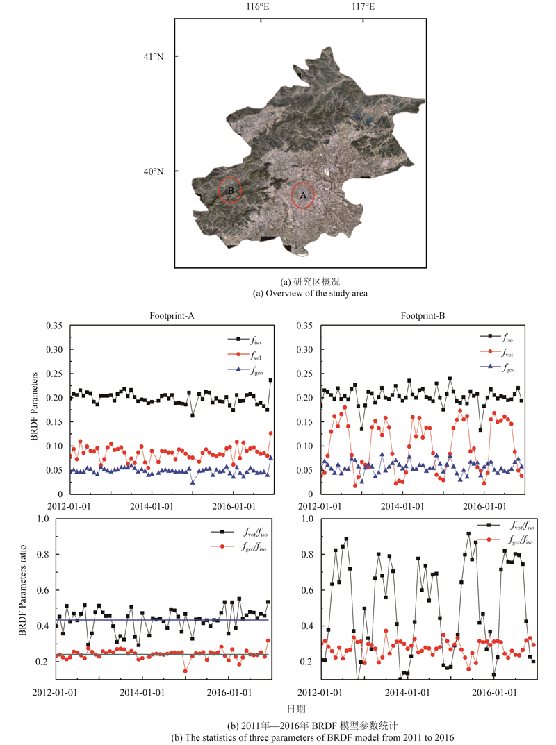
3.2 城市BRDF参数确定
从BRDF参数先验数据库,选取1.6 μm通道的数据。北京地区冬季地表会出现积雪,而积雪像元对二向反射率的分析带来较大影响,故对数据进行预处理将包含积雪的像元进行剔除。对预处理后的数据进行空间重采样,得到A、B两地的BRDF核系数(Schmidt 等,2012)。图2(b)统计了2011年—2016年共5年的BRDF等3个核系数的变化规律。可以看出,虽然A城市区域的BRDF等3个核系数随着季节会有改变,
3.3 反演误差分析与校正
为了定量研究地表二向反射对CO2反演的精度影响,分别使用绝对辐亮度法、比值法(叶函函 等,2013)和BRDF方法反演了GMI模拟数据。3种方法的差异在于绝对辐亮度基于地表反射的朗伯假设,比值法基于波段比值降低反射率不确定度的影响,而BRDF方法是基于地表二向反射的现实。3种反演结果的误差统计如图3所示。图3中太阳天顶角分别为16°,30°,46°和61°,取自不同季节北京地区的正午太阳天顶角,观测二向位于主平面上,观测天顶角依次增大分别为5°、10°、20°、30°、40°、50°、60°和70°。气溶胶的类型为城市型AOD为0.05,模拟用到的地表高程值,大气温度、湿度、压力廓线均来自于欧洲中期天气预报中心ECMWF(The European Centre for Medium-Range Weather Forecasts),地表BRDF参数从BRDF参数先验数据库中提取。

由于城市地表二向反射,使得观测光谱随着观测角度变化明显,绝对辐亮度法使用固定的地表反射率引入巨大误差,无法获取真实的CO2浓度。比值反演方法是当AOD较小时,忽略气溶胶的散射作用,此时认为观测辐亮度与地表反射率近似成线性,使用特定条件下的光谱点进行比值来消除地表反射的影响。比值反演方法的校正结果如图3中蓝色方形曲线所示,对地表反射率变化引起的CO2反演误差有较好的校正效果,多个观测条件下的最大误差0.8%。对于同时反演BRDF的反演方法如图3中绿色三角形所示,得到的反演结果在各个观测条件下,都非常稳定,很好的校正了地表反射率随着观测几何变化带来的反演误差,误差均小于0.1%。
在忽略气溶胶散射或者气溶胶散射作用较小的情况下,比值反演方法和BRDF方法均可较好地校正地表反射二向特性引入的反演误差。然而针对北京城区的大气条件,仅反演小值AOD观测数据,数据的利用率将大幅降低(张晗 等,2017)。改变模拟数据AOD值为0.4,其他条件设置与上文一致,比值法和BRDF方法反演结果如图4所示。当AOD较大时,卫星观测辐射强度与地表反射率呈近似线性关系的假设不成立。如图4(a)所示,比值法的反演结果在后向观测区域,反演误差平均为–1.26%,随着太阳天顶角增大,反演误差增大。在天顶角较大的时候,CO2的吸收光程较长,受到气溶胶散射的影响更大。在前向观测区域,随着太阳天顶角的增大,反演误差先减小后增大;随着观测天顶角的增加,反演误差也先减小后迅速增大。最大的反演误差可以达到4.75%。此时使用比值方法无法获取满足精度要求的反演结果。

由于同时反演了BRDF参数,图4(b)中结果显示气溶胶和地表反射耦合作用带来的反演误差被较好地校正。在观测天顶角小于50°时,反演结果稳定,误差几乎不随着天顶角变化而变化。在太阳天顶角小于30°时,校正效果最好,反演误差稳定,除了两端观测天顶角大于60°时,误差达到0.5%,其他误差均在0.1%之内。当太阳天顶角大于30°后,反演结果也比较稳定,但是反演误差增大,当太阳天地角为61°时,平均的反演误差为0.75%,而最大的反演误差出现在观测天顶角为70°时,误差为1.25%。模拟数据反演结果证明,同时反演BRDF的方法可以很好的校正由于地表二向反射而造成CO2反演误差,尤其是在AOD较大的时候,这种校正对于获取精确的大气CO2含量尤为重要。
为了检验该方法的实际效果,筛选2016年全年北京城市区域有GOSAT二级产品的数据点进行反演,反演中以GMI光谱带宽对GOSAT的光谱进行截断,以适应GMI反演算法的需要。结果如下图5所示,图5(a)、(b)、(c)、(d)分别为春季,夏季,秋季和冬季的反演结果,图5中蓝色线条为GOSAT NIES算法的反演结果加上误差修正作为BRDF方法反演结果的参考值。黑色三角点为比值法的反演结果,红色圆点为BRDF方法的反演结果,图5中黑色区域为参考值的0.5%误差范围,从图5上看,几乎所有BRDF方法的反演结果都在参考值的误差范围内。在北京地区春季和夏季,比值法反演多次超过误差范围,分析对应的AOD值,发现这些观测数据的AOD值都接近或大于0.3,而利用BRDF方法反演,对于这些点的反演结果都与参考值更为接近,且位于0.5%的误差范围内。统计了比值法和BRDF方法与参考值的相关性,如图6所示。其中比值法的总体相关性为0.56,而通过BRDF方法反演,其相关性升高为0.85。表3分别统计了2016年4个季节,比值反演法和BRDF方法的反演结果与参考值的相对误差均值、标准差和相关系数。从表3中对比可以看出,BRDF方法的相对误差均值和离散程度均较小。注意到2016年夏季,比值法和BRDF方法的反演结果与参考值的相关性都较差,分析这些异常点的原因主要是在较高的AOD的情况下(大于0.3),反演时气溶胶模式假设不准确造成的。

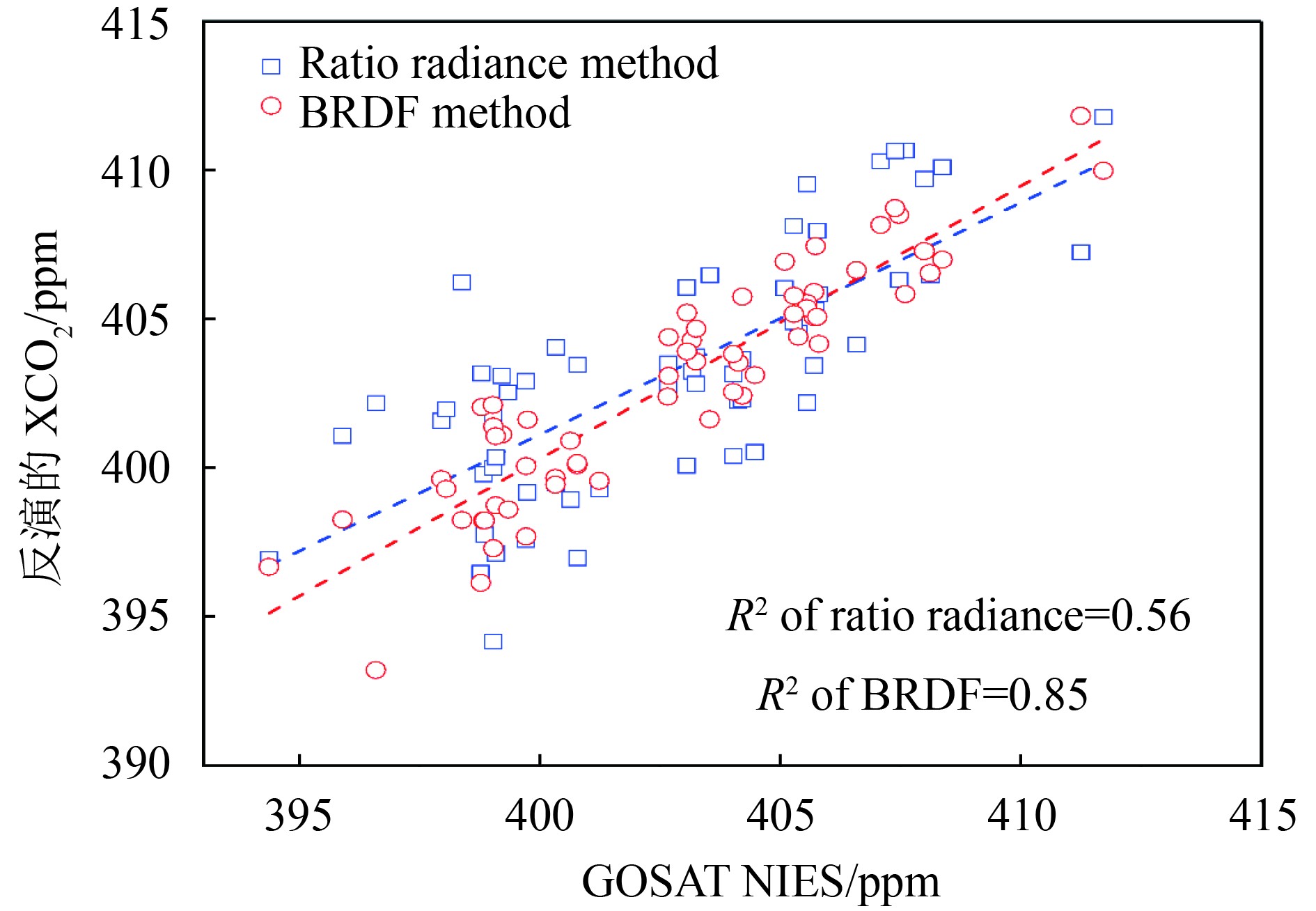
表 3 2016年4个季节比值法和BRDF方法的相对误差均值、相对误差标准差和相关系数
Table 3 Mean value, standard error and correlation coefficient of ratio method and BRDF method of each season in 2016
| ΔXCO2 /ppmv | 平均值 | 标准差 | 相关系数 | |||||
| 比值法 | BRDF方法 | 比值法 | BRDF方法 | 比值法 | BRDF方法 | |||
| 春季 | 1.75 | 1.13 | 2.24 | 1.22 | 0.59 | 0.83 | ||
| 夏季 | 3.46 | 1.81 | 3.61 | 2.03 | 0.01 | 0.36 | ||
| 秋季 | 2.53 | 1.16 | 2.76 | 1.45 | 0.17 | 0.73 | ||
| 冬季 | 1.64 | 0.91 | 2.11 | 1.12 | 0.72 | 0.87 | ||
4 结 论
城市下垫面方向反射对大气CO2反演结果的精度影响显著,如果不对其进行校正,将无法获取高精度CO2的浓度信息。本文统计了北京地区MODIS BRDF数据,构建了BRDF参数初值数据库。通过分析城市下垫面的BRDF特性,确定了城市BRDF模型参数。基于此提出反演CO2含量的同时反演地表BRDF参数的算法,可以有效校正地表二向反射和地气耦合带来的反演误差。结果表明:(1)对于GMI模拟数据,在AOD值为0.05的情况下,其CO2反演误差可以控制在0.1%(~0.4 ppm);当AOD值为0.4时,CO2反演误差大部分控制在0.5%(~2 ppm)。(2)应用在GOSAT实测数据上,与修正的GOSAT NIES反演结果相比,2016年全年的平均误差为1.25 ppm,相关性达到0.85。该算法的提出,为高精度反演北京城区大气CO2含量提供保障。同时对复杂地表环境和高值气溶胶条件下,大气CO2的反演提供了参考。
该算法对于GMI实测数据的反演效果,需要获得GMI在轨数据后进行进一步的评估。由于北京地区并无TCCON站点,在进行GMI数据的实际反演过程中,需要开展地面测量来验证反演精度和方法改进。同时注意到,对于城市这一气溶胶条件复杂的区域,更准确的气溶胶模型和气溶胶多参数的同时探测与联合反演会进一步提高城市地区大气CO2的反演精度。为目前和下一代,大气CO2监测载荷数据处理提供高精度反演算法。
参考文献(References)
-
Aben I, Hasekamp O and Hartmann W. 2007. Uncertainties in the space-based measurements of CO2 columns due to scattering in the Earth’s atmosphere . Journal of Quantitative Spectroscopy and Radiative Transfer, 104 (3): 450–459. [DOI: 10.1016/j.jqsrt.2006.09.013]
-
Dhakal S. 2009. Urban energy use and carbon emissions from cities in China and policy implications. Energy Policy, 37 (11): 4208–4219. [DOI: 10.1016/j.enpol.2009.05.020]
-
Friedl M A, McIver D K, Hodges J C F, Zhang X Y, Muchoney D, Strahler A H, Woodcock C E, Gopal S, Schneider A, Cooper A, Baccini A, Gao F and Schaaf C. 2002. Global land cover mapping from MODIS: algorithms and early results. Remote Sensing of Environment, 83 (1/2): 287–302. [DOI: 10.1016/S0034-4257(02)00078-0]
-
Hammerling D M, Michalak A M and Kawa S R. 2012. Mapping of CO2 at high spatiotemporal resolution using satellite observations: global distributions from OCO‐2 . Journal of Geophysical Research: Atmospheres, 117 (D6): D06306 [DOI: 10.1029/2011jd017015]
-
Liu Y, Yang D X and Cai Z N. 2013. A retrieval algorithm for TanSat XCO2 observation: retrieval experiments using GOSAT data . Chinese Science Bulletin, 58 (13): 1520–1523. [DOI: 10.1007/s11434-013-5680-y]
-
Myhrvold N P and Caldeira K. 2012. Greenhouse gases, climate change and the transition from coal to low-carbon electricity. Environmental Research Letters, 7 (1): 014019 [DOI: 10.1088/1748-9326/7/1/014019]
-
O’Dell C W, Connor B, Bösch H, O’Brien D, Frankenberg C, Castano R, Christi M, Eldering D, Fisher B, Gunson M, McDuffie J, Miller C E, Natraj V, Oyafuso F, Polonsky I, Smyth M, Taylor T, Toon G C, Wennberg P O and Wunch D. 2012. The ACOS CO2 retrieval algorithm-Part 1: description and validation against synthetic observations . Atmospheric Measurement Techniques, 5 (1): 99–121. [DOI: 10.5194/amtd-4-6097-2011]
-
Oishi Y, Ishida H, Nakajima T Y, Nakamura R and Matsunaga T. 2017. The impact of different support vectors on GOSAT-2 CAI-2 L2 cloud discrimination. Remote Sensing, 9 (12): 1236 [DOI: 10.3390/rs9121236]
-
Schmidt M, Udelhoven T, Röder A and Gill T K. 2012. Long term data fusion for a dense time series analysis with MODIS and Landsat imagery in an Australian Savanna. Journal of Applied Remote Sensing, 6 (1): 063512 [DOI: 10.1117/1.jrs.6.063512]
-
Shuai Y M, Schaaf C B, Strahler A H, Liu J C and Jiao Z T. 2008. Quality assessment of BRDF/albedo retrievals in MODIS operational system. Geophysical Research Letters, 35 (5): L05407 [DOI: 10.1029/2007gl032568]
-
Wang K C, Wang J K, Wang P C and Chen H B. 2008. The accuracy of MODIS albedo over Beijing Urban area and its algorithm improvement. Chinese Journal of Atmospheric Sciences, 32 (1): 67–74. [DOI: 10.3878/j.issn.1006-9895.2008.01.06] ( 王开存, 王建凯, 王普才, 陈洪滨. 2008. 用MODIS反演北京城市地区地表反照率精度以及算法改进. 大气科学, 32 (1): 67–74. [DOI: 10.3878/j.issn.1006-9895.2008.01.06] )
-
Wu H, Wang X H, Ye H H, Jiang Y and Duan F H. 2018. Error analysis of the greenhouse-gases monitor instrument short wave infrared XCO2 retrieval algorithm . Journal of Applied Remote Sensing, 12 (1): 016015 [DOI: 10.1117/1.jrs.12.016015]
-
Ye H H, Wang X H, Wu J, Fang Y H, Ma J J, Jiang X H and Wei Q Y. 2013. Study of the effect of surface reflectance on atmospheric CO2 retrieval and ratio spectrometry . Spectroscopy and Spectral Analysis, 33 (8): 2182–2187. [DOI: 10.3964/j.issn.1000-0593(2013)08-2182-06] ( 叶函函, 王先华, 吴军, 方勇华, 麻金继, 江新华, 韦秋叶. 2013. 大气CO2反演的地表反射率影响分析与比值反演方法 . 光谱学与光谱分析, 33 (8): 2182–2187. [DOI: 10.3964/j.issn.1000-0593(2013)08-2182-06] )
-
Yokota T, Yoshida Y, Eguchi N, Ota Y, Tanaka T, Watanabe H and Maksyutov S. 2009. Global concentrations of CO2 and CH4 retrieved from GOSAT: first preliminary results . Sola, 5 : 160–163. [DOI: 10.2151/sola.2009-041]
-
Zhang H, Jiao Z T, Dong Y D, Li J Y and Li X W. 2015. Albedo retrieved from BRDF archetype and surface directional reflectance. Journal of Remote Sensing, 19 (3): 355–367. ( 张虎, 焦子锑, 董亚东, 李佳悦, 李小文. 2015. 利用BRDF原型和单方向反射率数据估算地表反照率. 遥感学报, 19 (3): 355–367. )
-
Zhang H, Yu C, Su L, Li L J, Fan M, Wang Y P and Chen L F. 2017. Emission control effects observed from space during the military parade 2015 in Beijing. Journal of Remote Sensing, 21 (4): 622–632. ( 张晗, 余超, 苏林, 李令军, 范萌, 王雅鹏, 陈良富. 2017. MODIS和OMI数据评估阅兵期间北京市大气减排成效. 遥感学报, 21 (4): 622–632. )