
|
收稿日期: 2018-07-27; 预印本: 2018-10-26
基金项目: 国家自然科学基金青年基金(编号:41701536,61701047,41201468,41674040);湖南省自然科学基金青年基金(编号:2017JJ3322,2019JJ50639);湖南省教育厅优秀青年项目(编号:16B004);湖南省教育厅科学研究项目(编号:16C0043);湖南省教育厅科学研究重点项目(编号:18A148);长沙理工大学公路养护技术国家工程实验室开放基金资助项目(编号:kfj150105);长沙理工大学大学生研究性学习与创新实验计划项目
第一作者简介: 肖亮,1994年生,男,硕士研究生,研究方向为InSAR矿山监测与数据反演。E-mail:2570194165@qq.com
通信作者简介: 邢学敏,1983年生,女,副教授,研究方向为利用InSAR技术监测地表沉降。E-mail:xuemin.xing@csust.edu.cn
|
摘要
利用小基线集(SBAS)InSAR技术对钻井水溶岩盐矿山地表沉降开展时空分析。实验选取湖南常德某典型钻井水溶岩盐矿区为测试区,时间跨度为2016年2月—2017年2月的21景Sentinel-1影像数据,获取了测区的时序沉降序列。实验结果显示,矿区地表大量级沉降在2016年9月才开始呈现,沉降漏斗横向出现多峰值,矿区沉降整体空间分布上出现西南部整体片状、中部偏北离散带状沉降。这些沉降特征均与钻井水溶法开采特征保持一致。将实地水准测量形变数据和DInSAR形变结果与本文结果进行对比以评估结果可靠性。结果表明,SBAS技术获取结果与水准结果表现出较高一致性,从而为钻井水溶岩盐矿山地表沉降提供了一种更为有效的监测手段,也可为此类矿山地表形变时空演化规律分析提供参考。
关键词
SBAS-InSAR, D-InSAR, 矿区, 开采沉降, 钻井水溶法, 时序分析
Abstract
Mining-induced dynamic deformations over drilling water-soluble rock salt mines may result in sever progressive damages to surface buildings and infrastructures. Long-term dynamic monitoring and real-time analysis of rock salt mines are extremely important in preventing potential geological damages. In this study, the small-baseline subset (SBAS) InSAR technique is initially used to monitor the settlement of drilling water-soluble rock salt mines. A time series analysis is carried out to obtain the time–space characteristics of land subsidence caused by drilling water-soluble mining activities. Then, the temporal and spatial evolution of the settlement funnel is revealed. Subsequently, the monitoring results are compared with both DInSAR and leveling deformation results for the reliability assessment. A temporal and spatial analysis is conducted for the surface subsidence. A typical drilling water-soluble rock salt mine in Changde, Hunan Province, China was selected as the test area. Twenty-one scenes from the Sentinel-1 image data covering the period from February 2016 to February 2017 were used to obtain the time series settlement sequence of the survey area. Experimental results indicate that the large-scale surface settlement over the mining area began to appear in September 2016 and with the characteristics of sedimentation funnel-multiplied peaks in the horizontal direction. The overall spatial distribution of the subsidence in the mining area appears as an overall sheet-like shape in the southwest part and a discrete belt-like distribution in the north-central part. These subsiding characteristics are consistent with mining activities that use drilling water-soluble technology. To evaluate the reliability of the results, the field-leveling deformation data are compared with the DInSAR deformation data. The results obtained by the SBAS technology are highly consistent with the leveling results. This study confirms the feasibility of applying SBAS-InSAR technology to the settlement monitoring of drilling water-soluble salt rock mines. The findings can provide a reference for the preliminary determination of mining cavity locations, aid in the developmental analysis of the characteristics of subsidence bowls, and help improve the recovery rate of water-soluble mining mines.
Key words
SBAS-InSAR, D-InSAR, mining area, mining subsidence, drilling solution mining, time series analysis
1 引 言
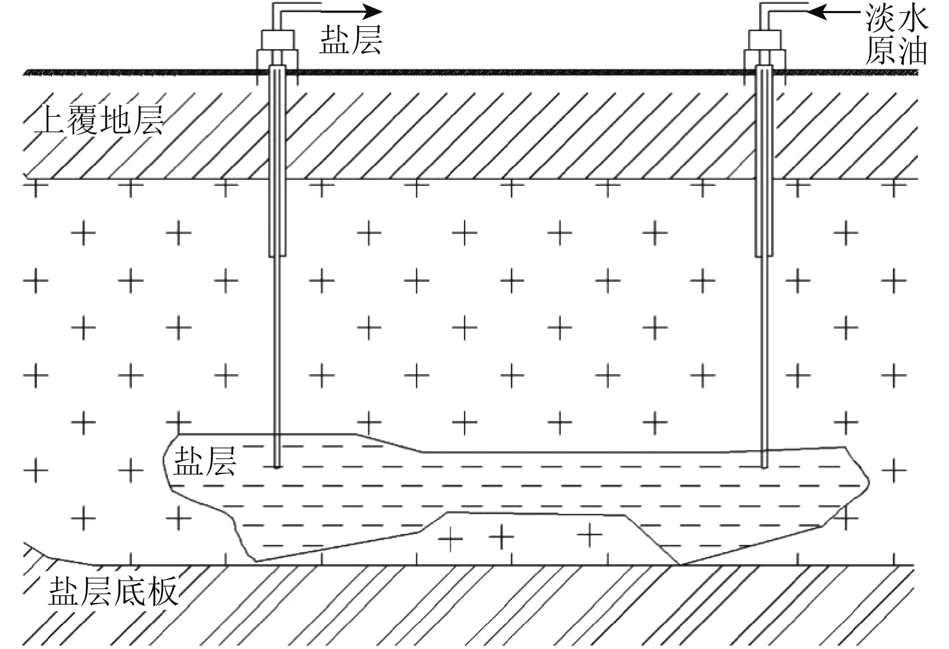
中国岩盐矿产资源丰富,已探明的储量约44500亿吨(王刚 等,2012)。其中岩盐开采90%以上采用钻井水溶法开采(曹烨 等,2018),即通过钻井注入溶剂,溶解矿层硐室,生成富含开采矿物的卤水,再将其从钻井中抽出(王清明,2001)。在开采中期因为多井溶腔相连,多进行两井或者多井同时开采。水溶开采法与传统煤矿巷道开采不同(梁卫国 等,2003),传统煤矿主要采用井工开采定向推进方式(宁宇,2013),而水溶法则为多方向推进,其采深比煤矿开采深度大。由于卤水溶解的时间和采深较大两方面因素,水溶法开采地表沉降在时间上往往呈现出滞后(欧阳兆祥,1990)。随着水溶开釆釆厚加大,形成的采空区导致上覆盐层发生下沉,其对地表的破坏不仅仅是地表塌陷导致的矿区岩体结构、地表地形、构筑物等的破坏,还极易引发地下卤水涌出,导致附近土地盐碱化,对环境破坏程度极为惊人。因此,水溶开采岩盐矿山的地面沉降更需进行长期监测。
传统矿区监测预警方法为人工勘察与水准测量,对于大面积矿区监测,传统方法工作量大、周期长、受气候限制、不可快速分析出矿山沉降过大位置,且不能反映整个矿区地表沉降情况。差分干涉测量DInSAR(Differential InSAR)技术作为一种新兴的对地观测技术,主要用于监测雷达视线方向厘米级或更微小的地球表面形变,以其监测范围大、空间分辨率高、无接触式测量等特点(Ma 等,2016;Wang 等,2012;Xing 等,2016;Yang 等,2016;尹宏杰 等,2011;李广宇 等,2018),大大弥补了传统测量手段的不足。然而,众所周知的时空失相关和大气延迟影响却限制了其监测精度。2002年Berardino提出小基线集技术SBAS(Small Baselinesubset),通过严格设置时空基线阈值来筛选干涉组合,并针对测区内的高相干点进行处理,以减弱时空失相干对变形结果的影响(Yang 等,2018a)。在利用SBAS-InSAR技术监测矿区变形方面已有众多成果,Alex监测了澳大利亚南部煤田地下煤矿开采引起的累积沉降(Ng 等,2010);尹宏杰等(2011)应用SBAS-InSAR技术于湖南冷水江锡矿山,进行矿山形变监测,揭示了矿区沉降漏斗的发展和演化过程;Tao和Liu(2014)利用7景L波段ALOS数据实现了对济宁煤矿区时间序列变形的监测,验证了L波段影像对矿区大变形梯度的监测实力;Diao等(2018)采用SBAS技术分析了邯郸煤矿矿山2013年10月—2014年3月的地表形变情况;Liu等(2018)运用时序InSAR对沛县北部煤矿的矿山废弃地进行沉降监测;Yang等(2017)运用时序InSAR对钱营孜煤矿进行监测,利用一个干涉对反演出矿区的三维形变场。但目前尚未见将InSAR技术应用于钻井水溶盐岩矿山地表沉降监测或地表移动规律研究方面的文献。由于钻井水溶法开采的特点,其地表水平移动变形值,远比相同条件下煤炭开采量级小(高威远,1991),地表沉降存在时间滞后,但沉降呈现后量级更大,对地表影响范围更广(张明黔和郎楷璐,1987;邢学敏 等,2016)。对岩盐水溶开采地面沉降开展长期的监测及变形规律分析研究,还有利于矿山资源的合理回收和保障矿山生态环境的安全。
鉴于此,本文探索性的将SBAS-InSAR技术应用于钻井水溶盐岩矿山沉降监测中,并利用获取的时间序列地表沉降开展时序分析,探讨钻井水溶法开采导致的地面沉降时空特征,揭示沉降漏斗的时空演化规律,与DInSAR结果及水准测量变形结果进行比较以评估SBAS方法在此类矿山中应用的可靠性。
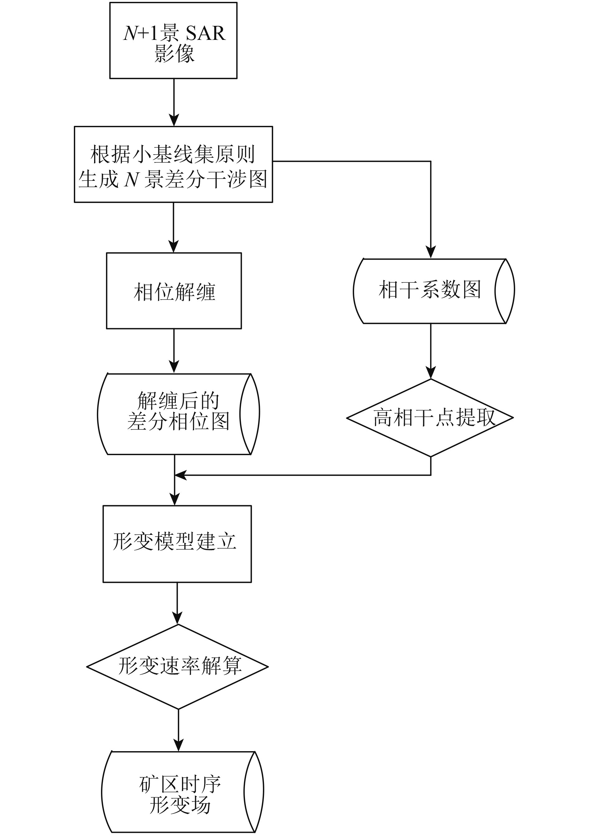
2 SBAS技术原理
假设有覆盖研究区的N+1景SAR影像(
| $\left({{{N}} + 1} \right)/2 < {{M}} < {{N}}\left({{{N}} + 1} \right)/2$ | (1) |
对其中任一干涉对,假设主影像获取时间为tA,从影像为tB(tA>tB,参考时间为t1),依次对各干涉组合进行影像干涉、去平、去地形、滤波和解缠处理(郭乐萍 等,2017),则对应高相干点
| $\begin{split} \delta {\phi _j} = & {\phi _{\rm{B}}}\left({x, r} \right) - {\phi _{\rm{A}}}\left({x, r} \right) \approx \frac{{4{\text{π}}}}{{\textit{λ}}}\left[ {d\left({{t_{\rm{B}}}, x, r} \right) - d\left({{t_{\rm{A}}}, x, r} \right)} \right] + \\ & \Delta \varphi _i^{{\rm{topo}}}\left({x, r} \right) + \Delta \varphi _i^{{\rm{res}}}\left({x, r} \right)\end{split}$ | (2) |
式中,
| $d\left({{{{t}}_{\rm{B}}}, x, r} \right) - d\left({{{{t}}_{\rm{A}}}, x, r} \right) = {v_i}\left({{{{t}}_{{\rm{B}} - }}{{{t}}_{\rm{A}}}} \right)$ | (3) |
式中,vi为tA至tB时段视线向平均形变速度。
式(3)化为矩阵形式为
| ${{Bv}} = {{\delta}} {{\phi}} $ | (4) |
如果有i个干涉对,则对应未知参数vi也为i个,且由于矩阵B为秩亏,需要采用奇异值分解法SVD(Singular Value Decomposition)求解(Casu 等,2006;雷广渊和周辉,2015),可最终获取形变速率的最小范数解,再通过对各时段内速度积分即可求出所有高相干点的时间序列形变值(Ali 等,2017;Narayan 等,2018;Reis 等,2015)。由于水溶开采法矿区地表水平移动值远远小于煤矿开采,在此忽略地表水平移动影响,将视线向形变换算为垂直向形变,即可获取测试矿区地表沉降序列结果。
3 实验数据与处理方法
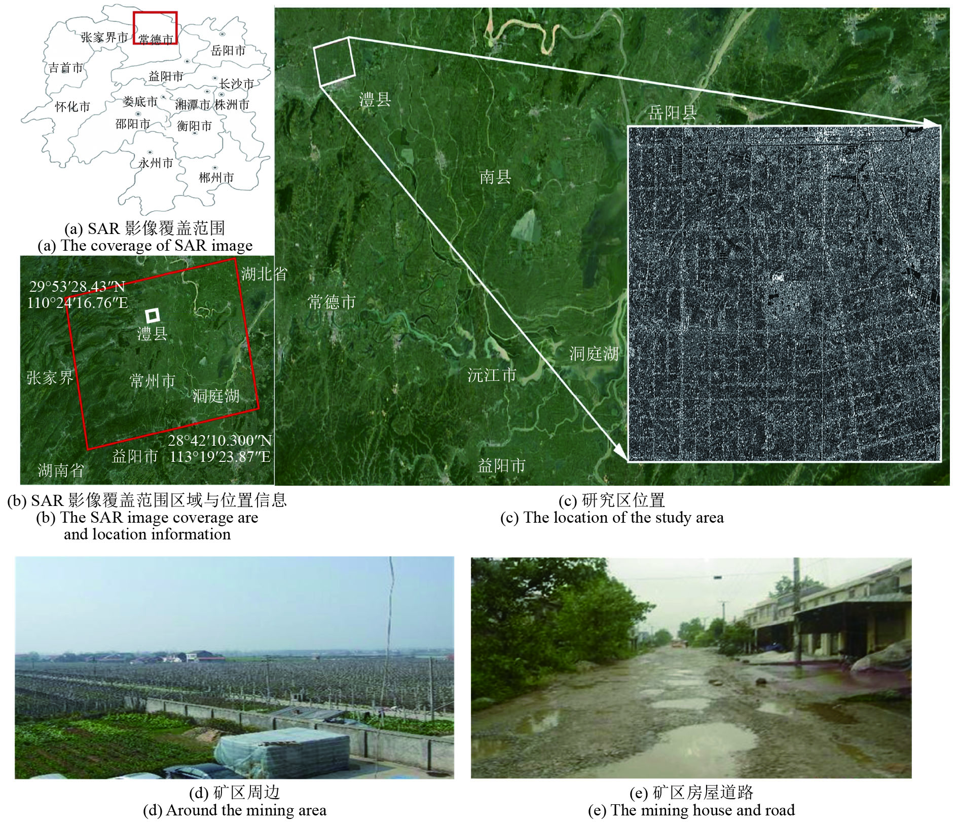
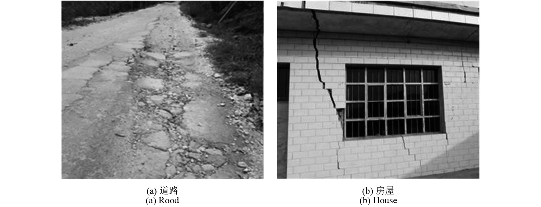
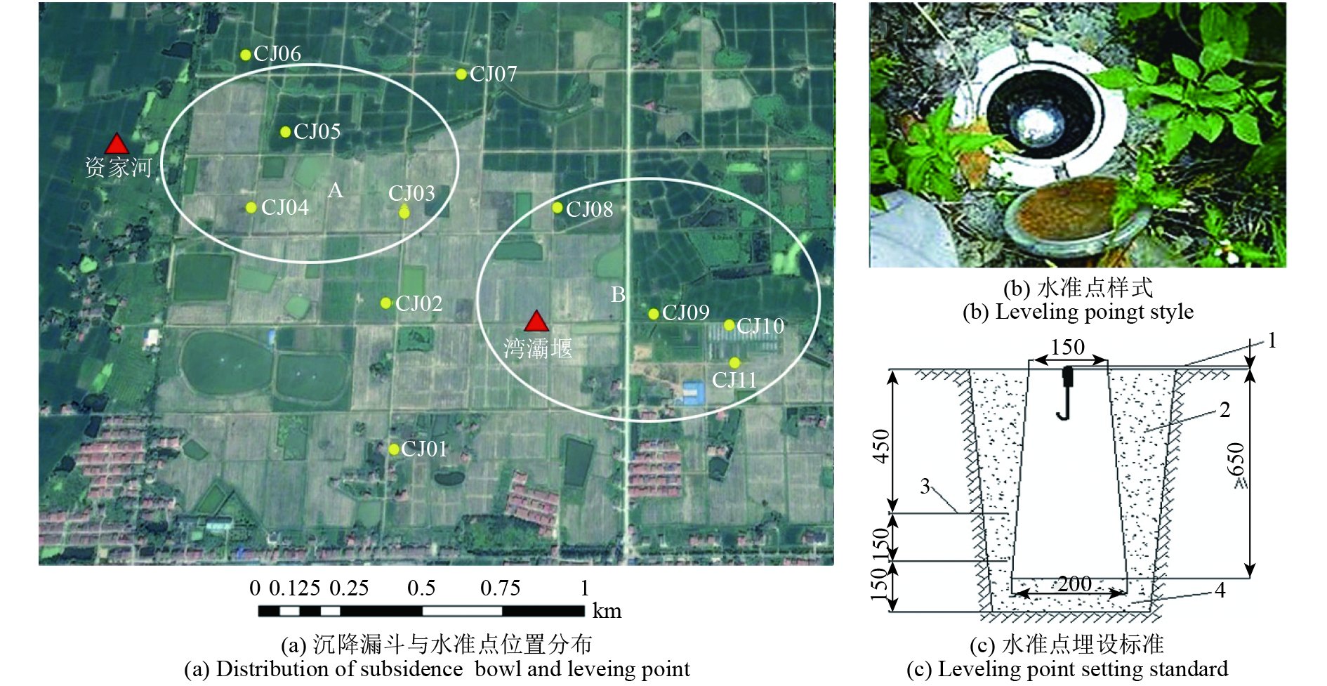
研究区域位于湖南省常德市澧县县城西北,为涔南乡辖区,是典型的钻井水溶开采矿山(东经111°43′31″—111°45′15″,北纬29°42′00″—29°42′59″),面积约为3.5 km2,(图1)。图1(a)、图1(b)中红色方框表示测区SAR影像的覆盖范围,图1(b)、图1(c)中白色矩形方框为本文截取的测试矿区位置。由图1(d)、图1(e)可见,测区属平原,地形较为平坦,居民地一般沿沟渠及公路两侧分布,测区内公路、大车道和乡村路等纵横交错,还包括一定面积的居民区及工业建筑区。矿区内矿岩系由灰绿至深灰色泥岩夹油页岩、泥云质钙芒硝岩、含硬石膏钙芒硝岩、无水芒硝岩及石盐岩组成(曹幼元,2006)。矿区建于2001年,采用钻井水溶法开采方式,年产量约为100万吨卤水,通过现场调研发现,由于长达17年的持续开采,矿区地表出现大量沉陷区域,房屋、道路均出现开裂现象(图14)。研究区地形平整,水系发达,稻田与民房较多(图1)。

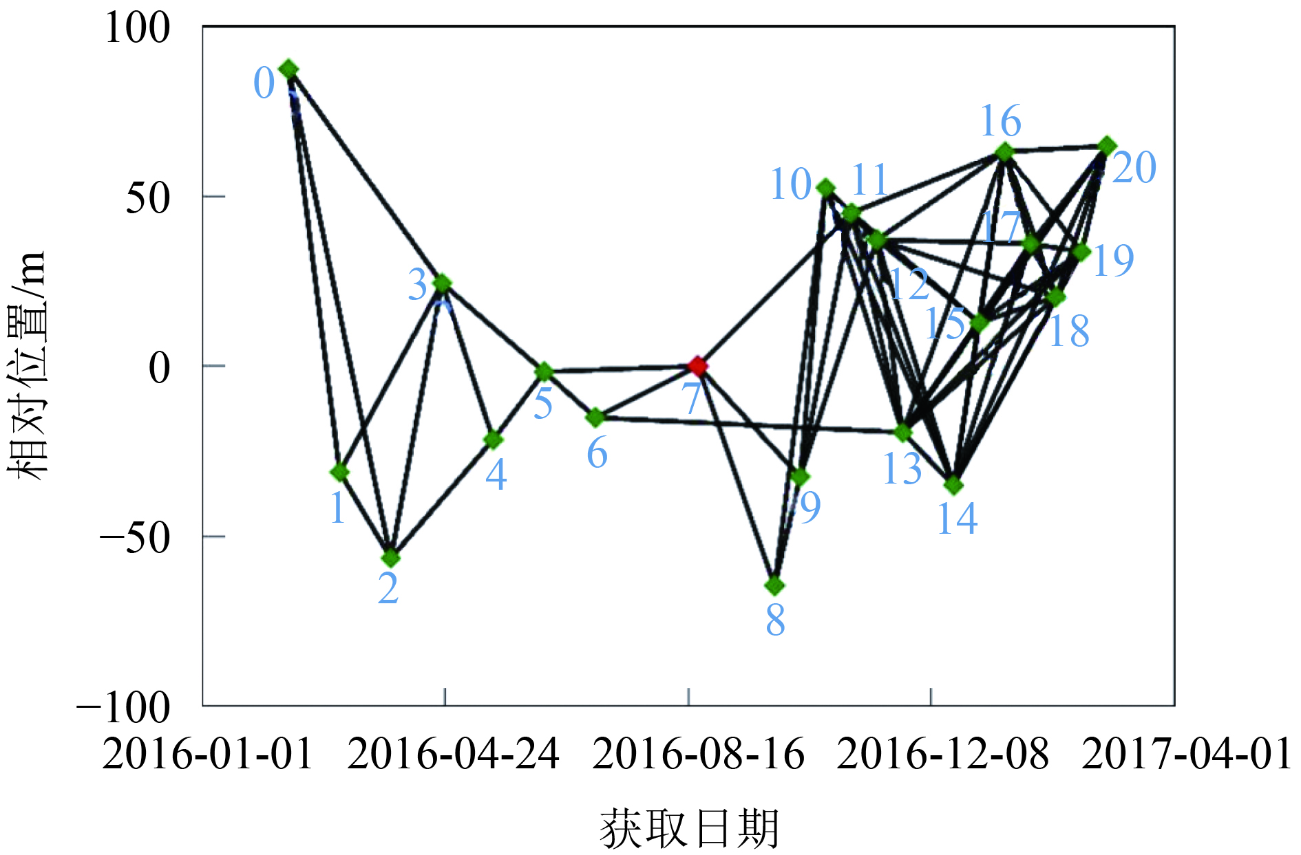
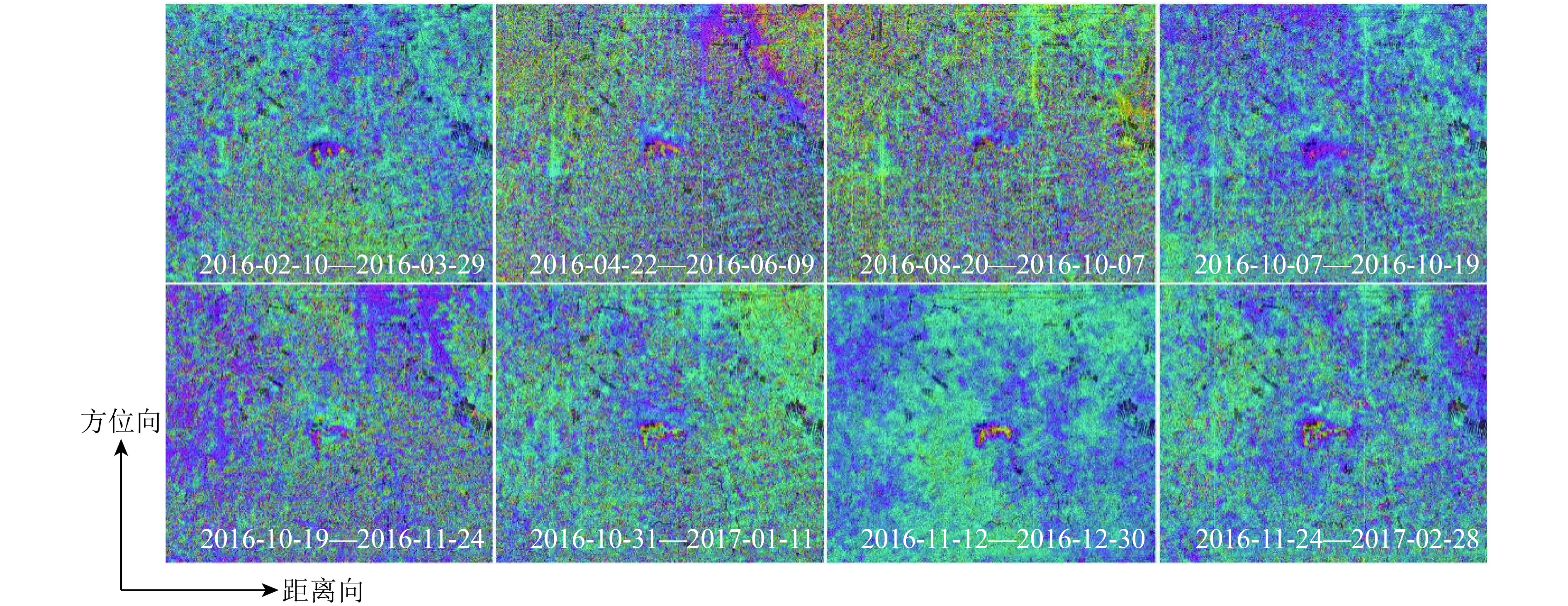
实验采用覆盖测区的21景Sentinel-1A升轨数据,软件环境为ENVI 5.3-IDL8.5版本;SARscape5.2版本;matlab r2015b版本;计算机操作内存为4 GB、主板为戴尔 03CPWF、处理器为英特尔第4代酷睿i5-4590、主硬盘为希捷ST1000DM003-1ER162。影像参数信息列于表1中,获取时间为2016年2月10日的为超级主影像。设置时间基线阈值为400 d,空间基线阈值为200 m,进行时空基线组合,时空基线分布见图2,最大时间基线为192 d,最大空间基线为87.374 m(Bakon 等,2017)。SBAS-InSAR处理操作流程图如图3。实验中外部DEM采用90 m SRTM DEM(Shuttle Radar Topography Mission Digital Elevation Model)数据,用于地形相位的去除(Solberg 等,2015)。通过差分干涉、去平、滤波和解缠,最终获取65个干涉对(部分差分干涉相位图如图4)(Ansari 等,2017;Jiang 等,2014;Jung 等,2014)。综合考虑相干系数,振幅指数和强度值进行高相干点选取(范锐彦 等,2016),设置相干系数阈值为0.5,振幅离差指数阈值为0.8,共选取出5380个高相干点。
表 1 Sentinel-1影像参数表
Table 1 Sentinel-1 data parameters
| 编号 | 轨道号 | 获取日期 | 轨道配置 | 垂直基线/m | 时间基线/d |
| 0 | 9883 | 2016-02-10 | ASCENDING | 87.374 | –192 |
| 1 | 10233 | 2016-03-05 | ASCENDING | –31.1557 | –168 |
| 2 | 10583 | 2016-03-29 | ASCENDING | –56.4835 | –144 |
| 3 | 10933 | 2016-04-22 | ASCENDING | 24.4083 | –120 |
| 4 | 11283 | 2016-05-16 | ASCENDING | –21.608 | –96 |
| 5 | 11633 | 2016-06-09 | ASCENDING | –1.66137 | –72 |
| 6 | 11983 | 2016-07-03 | ASCENDING | –15.1305 | –48 |
| 7 | 12683 | 2016-08-20 | ASCENDING | 0 | 0 |
| 8 | 13208 | 2016-09-25 | ASCENDING | –64.527 | 36 |
| 9 | 13383 | 2016-10-07 | ASCENDING | –32.5613 | 48 |
| 10 | 13558 | 2016-10-19 | ASCENDING | 52.4398 | 60 |
| 11 | 13733 | 2016-10-31 | ASCENDING | 45.0897 | 72 |
| 12 | 13908 | 2016-11-12 | ASCENDING | 37.1698 | 84 |
| 13 | 14083 | 2016-11-24 | ASCENDING | –19.471 | 96 |
| 14 | 14433 | 2016-12-18 | ASCENDING | –35.018 | 120 |
| 15 | 14608 | 2016-12-30 | ASCENDING | 12.7755 | 132 |
| 16 | 14783 | 2017-01-11 | ASCENDING | 63.0505 | 144 |
| 17 | 14958 | 2017-01-23 | ASCENDING | 36.0163 | 156 |
| 18 | 15133 | 2017-02-04 | ASCENDING | 20.4042 | 168 |
| 19 | 15308 | 2017-02-16 | ASCENDING | 33.65 | 180 |
| 20 | 15483 | 2017-02-28 | ASCENDING | 64.7922 | 192 |
4 实验结果分析及讨论
4.1 实验结果分析
由前文所述,最终获取了矿区2016年02月10日—2017年02月28日期间的平均沉降速率(图5)及时间序列沉降结果(图6)。

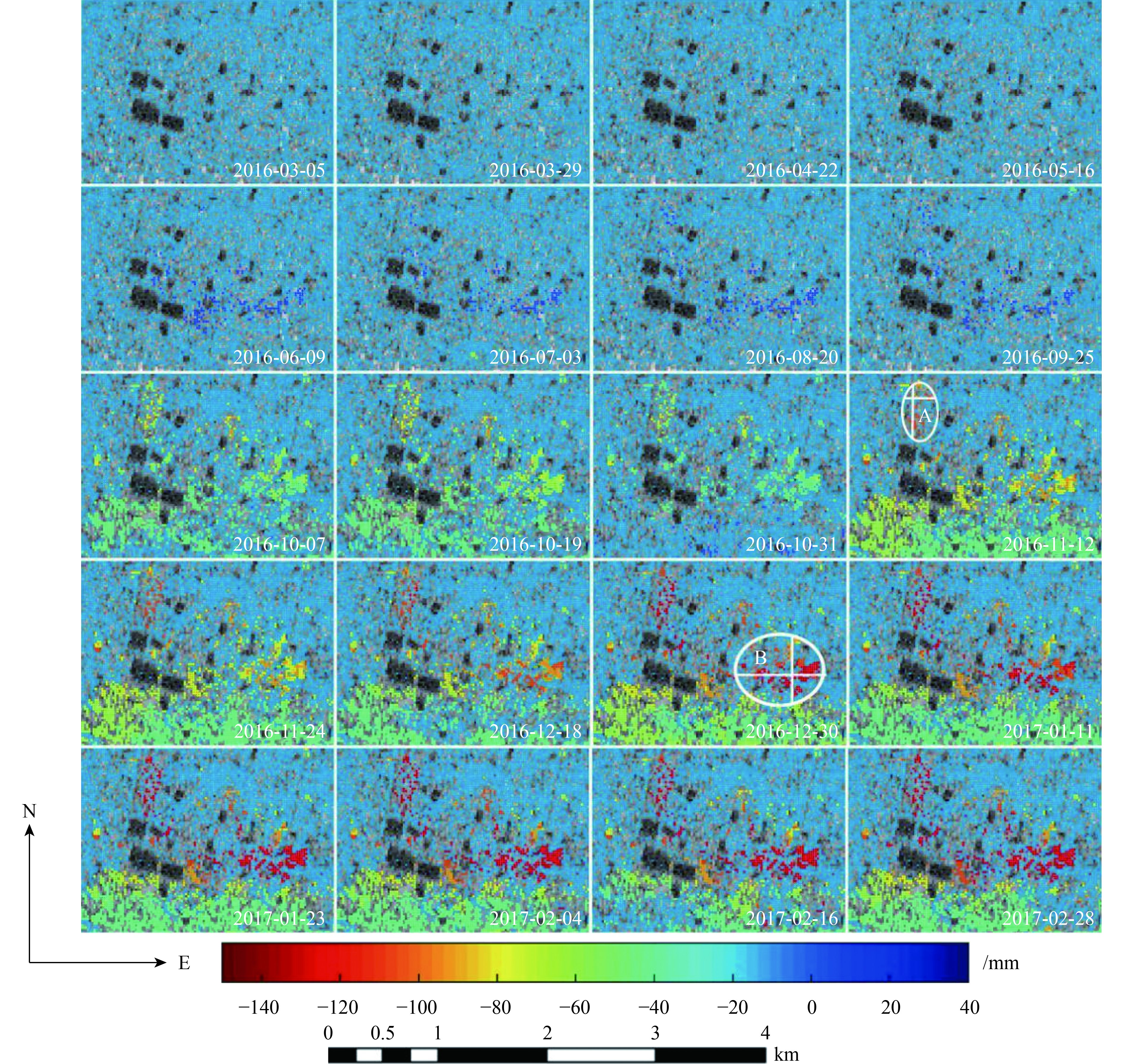
由图5可见,矿区整体平均沉降速率集中分布在20—30 mm/a,最大沉降速率值可达134 mm/a。红色与黄色沉降点主要分布在A、B区周边,远离矿井区域沉降量较小,为10—20 mm/a(颜色以蓝色为主)。A、B区均已存在发育的沉降漏斗。
图6为获取的矿区时间序列沉降结果(Pepe 等,2016;Zalite 等,2016)。由图6可见,从空间分布来看,矿区地表沉降较为明显的区域主要分布在矿区北部,最为明显的两个沉降漏斗出现在中东部和西北部位置,北部开采沉降影响区域较大。从时间上来看,在接近一年的时间里,矿区内最大沉降量达288 mm。从2016年2月10日—2016年4月22日,矿区沉降相对缓慢,沉降累积值为15 mm。从2016年2月—2016年6月,矿区中部区域出现隆起,量值达15 mm,主要原因是湖南省梅雨季节,降水量大,降水沉积在矿区地下,发生溶腔回灌,导致地面发生抬升。9月矿区开始出现大量级沉降,累积沉降最大值达95 mm。通过实地调研,2016年矿区从3月已开始实施了水溶开采,大量级沉降出现明显滞后。这一现象产生原因是钻井水溶法通过钻井注入溶剂,溶解矿层,生成卤水,再将其从钻井中抽出,这一过程较普通煤矿开采有时间滞后;水溶法采深较普通煤矿更深(本文研究区最大采深达270 m,平均采深达225.66 m)(曹烨 等,2018),导致地表沉降反映出现滞后现象。自2016年10月起,矿区整体空间分布上出现西南部大面积片状沉降,中部偏北呈离散带状沉降。这是由于分布于不同位置的钻井溶腔的溶解性不同。西南部多数钻井溶腔相互连通,采用的是多井开采方式,因此地表沉降呈现大面积整体片状沉降。中部偏北钻井溶腔多呈现离散分布,因此开采方式以双井连通开采为主,地表形变表现为离散带状沉降(图7)(吴敬涛 等,1999)。
测区面积约1.9 km2,高相干点覆盖面积约1.08 km2。对测试区域累积沉降量大于10 mm的点的个数及总面积进行分析。由表2可见,矿区在2016年2月—2016年9月期间沉降量集中分布于10—40 mm,累计沉降面积达0.23 km2。9月之后地表沉降区域迅速扩大,至2017年2月沉降面积为1.02 km2,其中沉降量大于100 mm的沉降面积达0.1 km2。
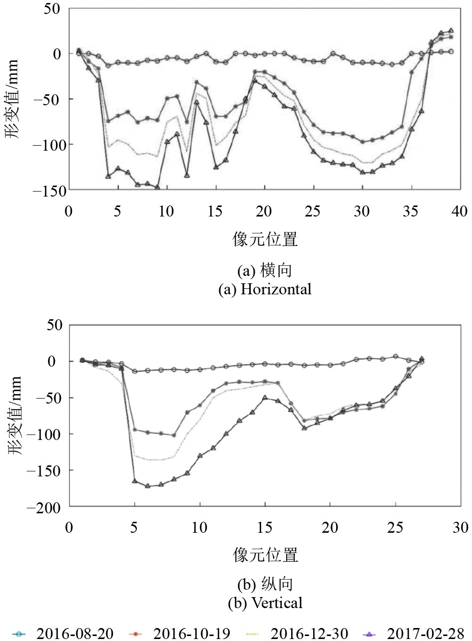
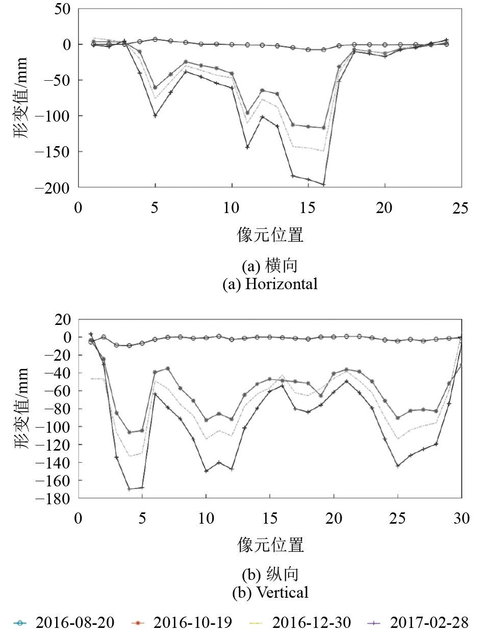
图6中可看到A、B两个较为明显的沉降漏斗,为分析漏斗的发育情况,取纵横剖面线进行分析,绘制沉降漏斗纵横剖面图如图8、图9。由图8可见,截止2017年2月28日,漏斗A横向有3个沉降峰值,分别为第9号像素,沉降量达148 mm、第12号像素沉降量达135 mm、第30号像素沉降量达131 mm,纵向有2个沉降峰值,分别为第6号像素,沉降量达172 mm、第18号像素,沉降量达93 mm。漏斗A附近区域的部分道路和房屋均出现开裂(图10)。漏斗B横向有2个峰值196 mm、144 mm,纵向有3个峰值170 mm、150 mm、144 mm。这种多峰值现象是因为水溶法开采为多向开采方式,且矿区地下有多个小溶腔发育引起。
表 2 矿区沉降面积统计表
Table 2 Mining settlement area statistics
| 日期 | 沉降面积/km2 | |||
| 30 mm>
沉降量> 10 mm |
70 mm>
沉降量> 30 mm |
100 mm>
沉降量> 70 mm |
沉降量>
100 mm |
|
| 2016-03-05 | 0.013 | 0 | 0 | 0 |
| 2016-03-29 | 0.012 | 0 | 0 | 0 |
| 2016-04-22 | 0.098 | 0 | 0 | 0 |
| 2016-05-16 | 0.253 | 0 | 0 | 0 |
| 2016-06-09 | 0.145 | 0 | 0 | 0 |
| 2016-07-03 | 0.229 | 0 | 0 | 0 |
| 2016-08-20 | 0.243 | 0 | 0 | 0 |
| 2016-09-25 | 0.229 | 0 | 0 | 0 |
| 2016-10-07 | 0.213 | 0.078 | 0.019 | 0.005 |
| 2016-10-19 | 0.192 | 0.074 | 0.038 | 0.010 |
| 2016-10-31 | 0.241 | 0.040 | 0.012 | 0.001 |
| 2016-11-12 | 0.822 | 0.124 | 0.066 | 0.064 |
| 2016-11-24 | 0.911 | 0.072 | 0.028 | 0.065 |
| 2016-12-18 | 0.925 | 0.053 | 0.024 | 0.074 |
| 2016-12-30 | 0.764 | 0.162 | 0.052 | 0.098 |
| 2017-01-11 | 0.823 | 0.139 | 0.025 | 0.090 |
| 2017-01-23 | 0.808 | 0.147 | 0.027 | 0.094 |
| 2017-02-04 | 0.788 | 0.161 | 0.030 | 0.097 |
| 2017-02-16 | 0.905 | 0.066 | 0.016 | 0.090 |
| 2017-02-28 | 0.831 | 0.115 | 0.027 | 0.103 |
4.2 结果精度验证
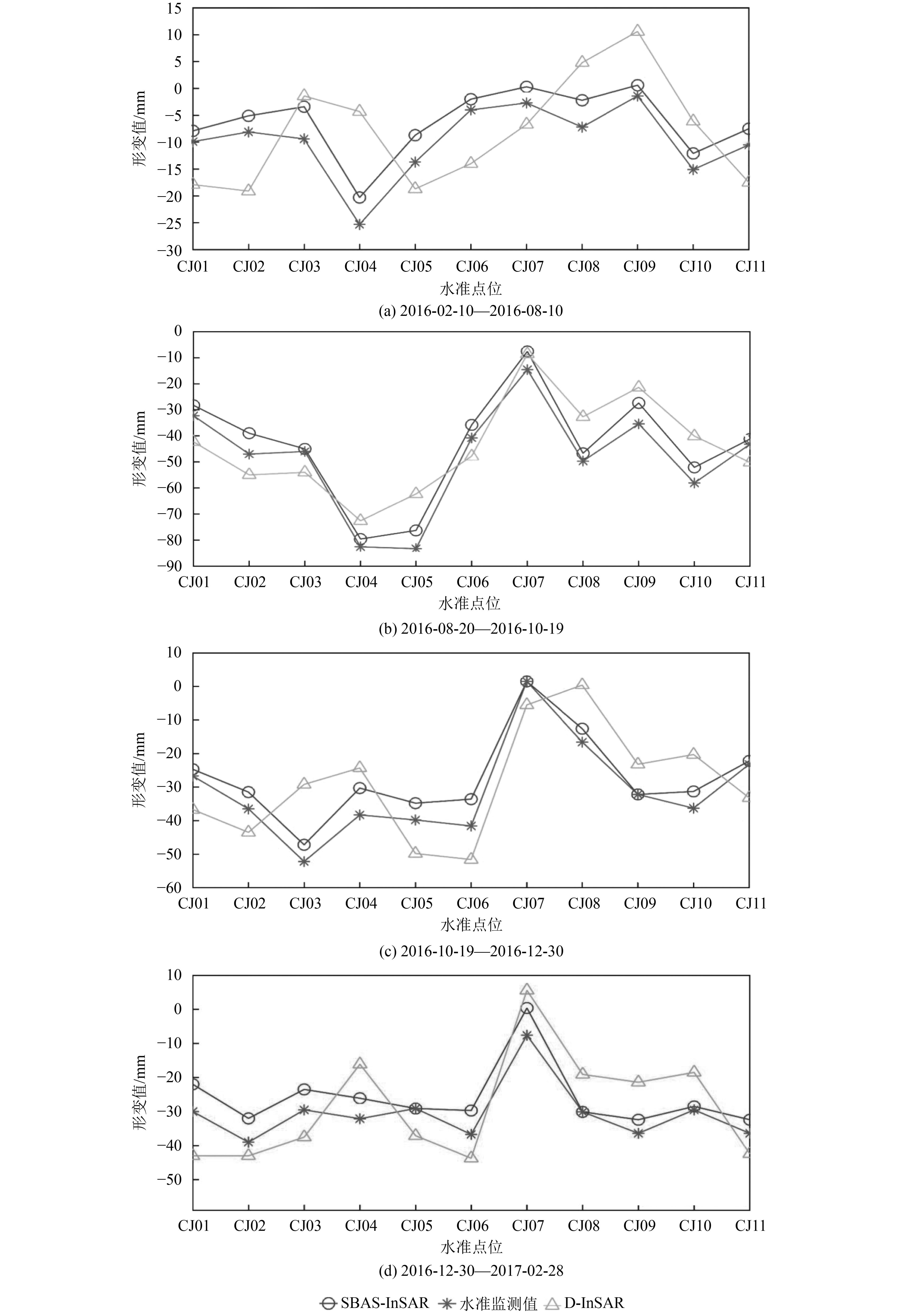
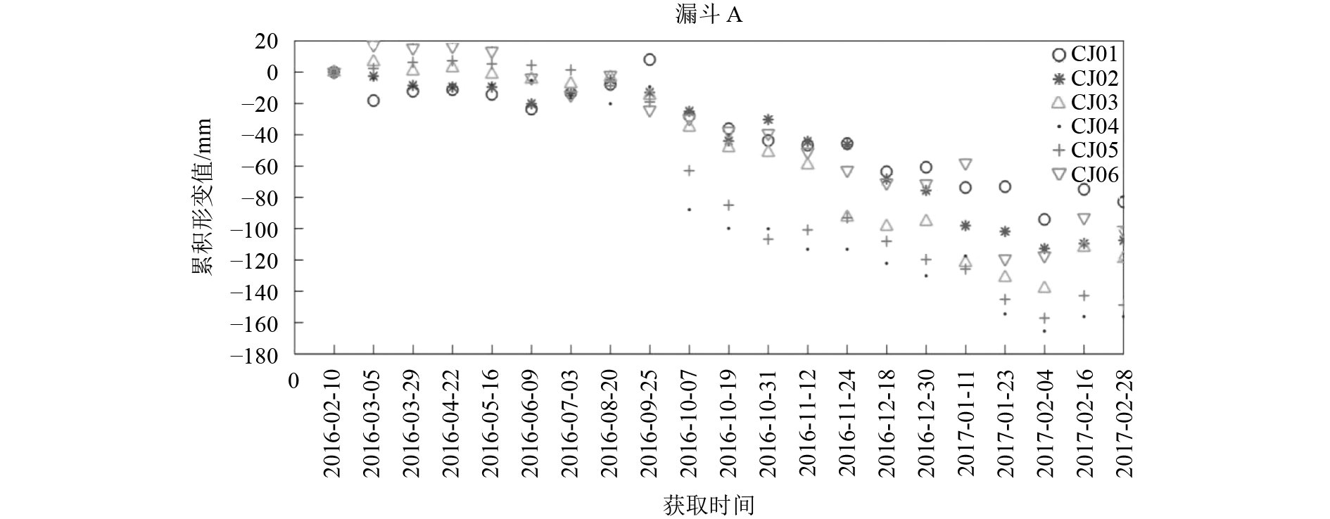
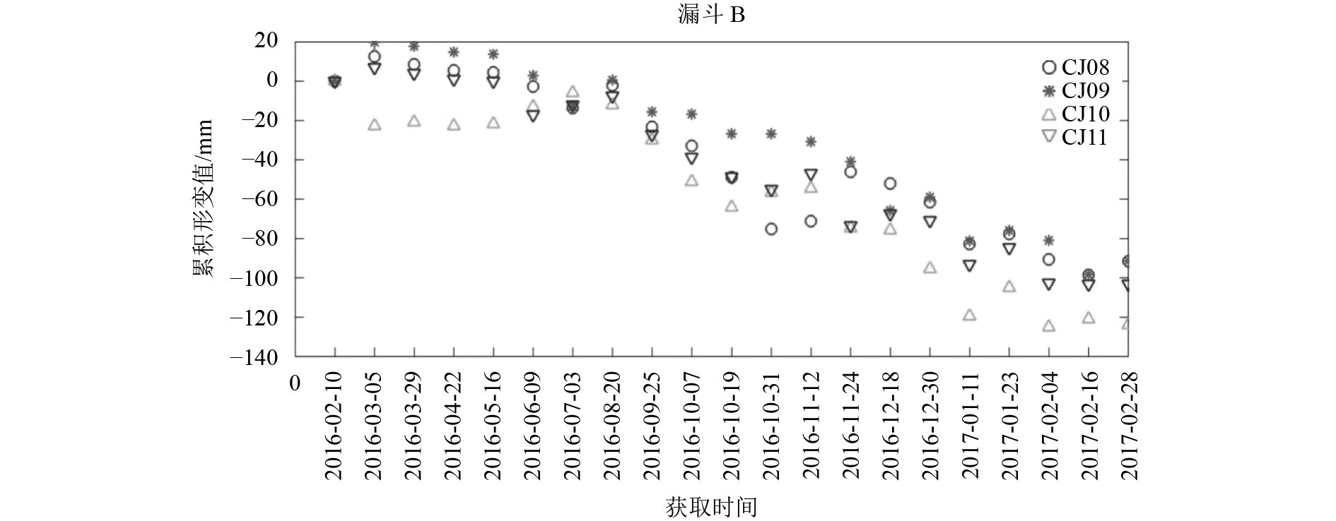
研究矿区内共布设水准点131个,包括129个监测点与2个基准点,共布设7个闭合环,开展往返二等水准测量, 各闭合环环线闭合差为:6.3 mm、3.1 mm、8.6 mm、2.5 mm、5.1 mm、8.3 mm、6.4 mm;测区偶然中误差为:±1.8 mm、全中误差为:±3.2 mm,满足二等水准测量精度要求。利用获取的水准变形数据,选取漏斗周边保存较好的10个水准点(图13),用于验证本文的结果。其中CJ01—CJ06等6个水准点位于漏斗A区附近,CJ08—CJ11等4个水准点位于漏斗B附近。为与本文获取的实验结果进行比对,采用100 m内平均值法提取出水准点的SBAS结果,其时序沉降表示在图11—12中(王艳 等,2007)。漏斗A位于点CJ02—CJ06,中心在点CJ05附近,最大沉降值为156 mm。漏斗B位于点CJ09—CJ11,中心在点CJ11附近,最大沉降值为124 mm。从图11和图12还可以看出,漏斗A在2016年6—9月,漏斗B在2016年6—8月期间形变出现轻微抬升。通过对往年水准实测数据分析和测区天气情况的调研,2016年4月—9月该地区降水量丰富,地下水位上升,雨水下渗与地下水回灌溶腔,使矿区内部分区域出现抬升现象。9月后为平水期与枯水期,外界水量干扰较小,矿区沉降明显。水准测量形变结果与DInSAR和SBAS结果对比表示如图14,可知水准数据沉降量比SBAS结果沉降量大。本文获取的SBAS结果与水准实测数据误差最大为8 mm,D-InSAR结果与水准实测数据误差最大为23 mm,SBAS结果与水准实测数据的均方根误差为±4.9 mm,D-InSAR结果与水准实测数据的均方根误差为±11.7 mm。SBAS方法与水准结果表现出较好的一致性。
5 结 论
本文将SBAS-InSAR技术应用于钻井水溶盐岩矿山地表形变监测中。实验选取湖南某水溶盐为测试区域,利用21景覆盖测区的Sentinel-1卫星影像开展小基线组合试验,通过设置时空基线阈值获取了210个质量较好的组合,并生成对应滤波、去平、解缠后的差分干涉图。综合考振幅离差指数,相干系数和强度值提取测区的高相干点,建立相位与形变速率的时序形变模型,利用SVD方法解算形变速率,进而获取高相干点为期一年的时间序列形变结果。实验结果显示,2016年2月—2016年4月,最大累积沉降仅为15 mm。表明此矿区前期沉降量较小,地表并未发生较快形变,原因为钻井水溶矿山采深大,地表形变的呈现存在时间滞后。自2016年9月起,大量级沉降开始呈现,矿区累积最大沉降可达222 mm。矿区沉降整体空间分布上出现西南部整体片状、中部偏北离散带状沉降。实验中发现矿区内存在两个典型沉降漏斗,为揭示矿区的沉降规律,对漏斗开展了纵横剖面分析,并对漏斗周边的水准点进行了时序沉降分析,实验发现漏斗A横向有3个沉降峰值,分别为第9号像素,沉降量达148 mm、第12号像素沉降量达135 mm、第30号像素沉降量达131 mm。沉降漏斗多峰值现象符合水溶法开采多向推进的特征。沉降峰值的位置与矿区钻井溶腔的位置吻合。利用D-InSAR和水准形变数据对本文结果进行验证,与水准实测数据均方根误差为±4.9 mm,表现出较好的一致性。本文的结果证实了SBAS-InSAR技术应用于钻井水溶盐岩矿山沉降监测的可行性,且能为初步确定开采溶腔位置和分析漏斗发育特征提供依据,对于提高水溶开采矿山回采率,盐岩矿山环境监测和保障安全生产具有重要意义。后期工作中将会集中在结合矿山开采沉陷预计理论模型,反演出预计参数,实现后续矿山开采沉陷变形的预计。
志 谢 本文采用的Sentinel-1A卫星影像由欧洲航天局(ESA)提供。感谢课题组刘聪、张琪开展的矿区水准变形测量,为本文提供了丰富的验证数据。
参考文献(References)
-
Ali I, Barrett B, Cawkwell F, Green S, Dwyer E and Neumann M. 2017. Application of repeat-pass TerraSAR-X staring spotlight interferometric coherence to monitor pasture biophysical parameters: limitations and sensitivity analysis. IEEE Journal of Selected Topics in Applied Earth Observations and Remote Sensing, 10 (7): 3225–3231. [DOI: 10.1109/JSTARS.2017.2679761]
-
Ansari H, De Zan F and Bamler R. 2017. Sequential estimator: a novel approach for efficient high-precision analysis of interferometric time series//2017 IEEE International Geoscience and Remote Sensing Symposium. Fort Worth, TX, USA: IEEE: 980–983 [DOI: 10.1109/IGARSS.2017.8127118]
-
Bakon M, Oliveira I, Perissin D, Sousa J J and Papco J. 2017. A data mining approach for multivariate outlier detection in postprocessing of multitemporal InSAR results. IEEE Journal of Selected Topics in Applied Earth Observations and Remote Sensing, 10 (6): 2791–2798. [DOI: 10.1109/JSTARS.2017.2686646]
-
Cao Y, Qiu G Y and Zou Z D. 2018. Analysis on salt mine resources and its industrial situation in China. Inorganic Chemicals Industry, 50 (3): 1–5. ( 曹烨, 邱国玉, 邹振东. 2018. 中国盐矿资源概况及其产业形势分析. 无机盐工业, 50 (3): 1–5. )
-
Cao Y Y. 2006. Expectational research about stochastic media theories of ground surface movements for drilling solution mining. Hunan Nonferrous Metals, 22 (5): 4–7. [DOI: 10.3969/j.issn.1003-5540.2006.05.002] ( 曹幼元. 2006. 钻井水溶法开采矿区地表移动随机介质理论预计研究. 湖南有色金属, 22 (5): 4–7. [DOI: 10.3969/j.issn.1003-5540.2006.05.002] )
-
Casu F, Manzo M and Lanari R. 2006. A quantitative assessment of the SBAS algorithm performance for surface deformation retrieval from DInSAR data. Remote Sensing of Environment, 102 (3/4): 195–210. [DOI: 10.1016/j.rse.2006.01.023]
-
Diao X P, Bai Z H, Wu K, Zhou D W and Li Z L. 2018. Assessment of mining-induced damage to structures using InSAR time series analysis: a case study of Jiulong Mine, China. Environmental Earth Sciences, 77 (5): 166 [DOI: 10.1007/s12665-018-7353-2]
-
Fan R Y, Jiao J, Gao S and Zeng Q M. 2016. Comparison research of high coherent target selection based on InSAR time series analysis. Journal of Geo-information Science, 18 (6): 805–814. [DOI: 10.3724/SP.J.1047.2016.00805] ( 范锐彦, 焦健, 高胜, 曾琪明. 2016. InSAR时序分析高相干目标选取方法比较研究. 地球信息科学学报, 18 (6): 805–814. [DOI: 10.3724/SP.J.1047.2016.00805] )
-
Gao W Y. 1991. Study on Surface Deformation Law Caused by Underground Mining of Rock Salt Mine. China Well and Rock Salt (3): 17–21. ( 高威远. 1991. 岩盐矿山地下开采引起地表变形规律初探. 中国井矿盐 (3): 17–21. )
-
Guo L P, Yue J P and Yue S. 2017. Application of SBAS technique in surface subsidence monitoring of Nanjing Hexi Area. Bulletin of Surveying and Mapping (3): 26–28, 41. [DOI: 10.13474/j.cnki.11-2246.2017.0077] ( 郭乐萍, 岳建平, 岳顺. 2017. SBAS技术在南京河西地表沉降监测中的应用. 测绘通报 (3): 26–28, 41. [DOI: 10.13474/j.cnki.11-2246.2017.0077] )
-
Jiang M, Ding X L, Li Z W, Tian X, Wang C S and Zhu W. 2014. InSAR coherence estimation for small data sets and its impact on temporal decorrelation extraction. IEEE Transactions on Geoscience and Remote Sensing, 52 (10): 6584–6596. [DOI: 10.1109/TGRS.2014.2298408]
-
Jung J, Kim D J and Park S E. 2014. Correction of atmospheric phase screen in time series InSAR Using WRF model for monitoring volcanic activities. IEEE Transactions on Geoscience and Remote Sensing, 52 (5): 2678–2689. [DOI: 10.1109/TGRS.2013.2264532]
-
Kuri M, Bhattacharya A, Arora M K and Sharma M L. 2016. Time series insar techniques to estimate deformation in a landslide-prone area in Haridwar region, India//2016 IEEE International Geoscience and Remote Sensing Symposium. Beijing: IEEE: 6839–6842 [DOI: 10.1109/IGARSS.2016.7730785]
-
Lei G Y and Zhou H. 2015. On the law of metal mining subsidence based on SBAS. Engineering of Surveying and Mapping, 24 (3): 40–46. [DOI: 10.19349/j.cnki.issn1006-7949.2015.03.009] ( 雷广渊, 周辉. 2015. 基于SBAS技术的金属矿山沉陷规律研究. 测绘工程, 24 (3): 40–46. [DOI: 10.19349/j.cnki.issn1006-7949.2015.03.009] )
-
Li G Y, Zhang R, Liu G X, Yu B, Zhang B, Dai K R, Bao J W and Wei B W. 2018. Land subsidence detection and analysis over Beijng-Tianjin-Hebei area based on Sentinel-1A TS-DInSAR. Journal of Remote Sensing, 22 (4): 633–646. [DOI: 10.11834/jrs.20187196] ( 李广宇, 张瑞, 刘国祥, 于冰, 张波, 戴可人, 包佳文, 韦博文. 2018. Sentinel-1A TS-DInSAR京津冀地区沉降监测与分析. 遥感学报, 22 (4): 633–646. [DOI: 10.11834/jrs.20187196] )
-
Li S S, Li Z W, Hu J, Sun Q and Yu X Y. 2013. Investigation of the seasonal oscillation of the permafrost over Qinghai-Tibet Plateau with SBAS-InSAR algorithm. Chinese Journal of Geophysics, 56 (5): 1476–1486. [DOI: 10.6038/cjg20130506] ( 李珊珊, 李志伟, 胡俊, 孙倩, 俞晓莹. 2013. SBAS-InSAR技术监测青藏高原季节性冻土形变. 地球物理学报, 56 (5): 1476–1486. [DOI: 10.6038/cjg20130506] )
-
Liang W G, Zhao Y S and Wang R F. 2003. Back analysis of rock salt cavity in solution mining. Mining Research and Development, 23 (4): 11–14. [DOI: 10.3969/j.issn.1005-2763.2003.04.004] ( 梁卫国, 赵阳升, 王瑞凤. 2003. 水溶开采岩盐溶腔形状的反演分析. 矿业研究与开发, 23 (4): 11–14. [DOI: 10.3969/j.issn.1005-2763.2003.04.004] )
-
Liu X X, Wang Y J and Yan S Y. 2018. Interferometric SAR Time series analysis for ground subsidence of the abandoned Mining Area in North Peixian using Sentinel-1A TOPS data. Journal of the Indian Society of Remote Sensing, 46 (3): 451–461. [DOI: 10.1007/s12524-017-0708-4]
-
Ma C, Cheng X Q, Yang Y L, Zhang X K, Guo Z Z and Zou Y F. 2016. Investigation on mining subsidence based on multi-temporal InSAR and time-series analysis of the small baseline subset—Case study of working faces 22201-1/2 in Bu’ertai Mine, Shendong Coalfield, China. Remote Sensing, 8 (11): 951 [DOI: 10.3390/rs8110951]
-
Narayan A B, Tiwari A, Dwivedi R and Dikshit O. 2018. Persistent scatter identification and look-angle error estimation using similar time-series interferometric pixels. IEEE Geoscience and Remote Sensing Letters, 15 (1): 147–150. [DOI: 10.1109/LGRS.2017.2778421]
-
Ng A H M, Ge L L, Yan Y G, Li X J, Chang H C, Zhang K and Rizos C. 2010. Mapping accumulated mine subsidence using small stack of SAR differential interferograms in the Southern coalfield of New South Wales, Australia. Engineering Geology, 115 (1/2): 1–15. [DOI: 10.1016/j.enggeo.2010.07.004]
-
Ning Y. 2013. Current status and thinking of full-mechanized mining technology in Chinese coal mines. Coal Mining Technology, 18 (1): 1–4. [DOI: 10.3969/j.issn.1006-6225.2013.01.001] ( 宁宇. 2013. 我国煤矿综合机械化开采技术现状与思考. 煤矿开采, 18 (1): 1–4. [DOI: 10.3969/j.issn.1006-6225.2013.01.001] )
-
Ouyang Z X. 1990. Experimental study on dissolution rate of glauberite. Chemical Mining Technology (5): 4–6. [DOI: 10.16283/j.cnki.hgkwyjg.1990.05.002] ( 欧阳兆祥. 1990. 芒硝矿的溶解速度试验研究. 化工矿山技术 (5): 4–6. [DOI: 10.16283/j.cnki.hgkwyjg.1990.05.002] )
-
Pepe A, Solaro G, Calò F and Dema C. 2016. A minimum acceleration approach for the retrieval of multiplatform InSAR deformation time series. IEEE Journal of Selected Topics in Applied Earth Observations and Remote Sensing, 9 (8): 3883–3898. [DOI: 10.1109/JSTARS.2016.2577878]
-
Reis A R, Catalão J, Vieira G and Nico G. 2015. Mitigation of atmospheric phase delay in InSAR time series using ERA-interim model, GPS and MODIS data: application to the permafrost deformation in Hurd Peninsula, Antarctica//2015 IEEE International Geoscience and Remote Sensing Symposium. Milan, Italy: IEEE: 3454–3457 [DOI: 10.1109/IGARSS.2015.7326563]
-
Solberg S, Weydahl D J and Astrup R. 2015. Temporal stability of X-band single-pass InSAR heights in a spruce forest: effects of acquisition properties and season. IEEE Transactions on Geoscience and Remote Sensing, 53 (3): 1607–1614. [DOI: 10.1109/TGRS.2014.2346473]
-
Tao Q X and Liu G L. 2014. Properties of L-band differential InSAR for monitoring mining-induced subsidence in coalfield of Jining, Northern China. Journal of Central South University, 21 (4): 1508–1517. [DOI: 10.1007/s11771-014-2091-4]
-
Wang G, Guo G L, Zhou C R, Tan X L and Zheng J B. 2012. Research on surface subsidence prediction for drilling solution mining. China Mining Magazine, 21 (6): 104–107. [DOI: 10.3969/j.issn.1004-4051.2012.06.028] ( 王刚, 郭广礼, 周春蓉, 谭显龙, 郑杰炳. 2012. 钻井水溶法开采的地表沉陷预计研究. 中国矿业, 21 (6): 104–107. [DOI: 10.3969/j.issn.1004-4051.2012.06.028] )
-
Wang Q M. 2001. The development and prospect of solution mining. Salt Industry History Research (1): 40–43. [DOI: 10.3969/j.issn.1003-9864.2001.01.001] ( 王清明. 2001. 钻井水溶开采技术的发展与展望. 盐业史研究 (1): 40–43. [DOI: 10.3969/j.issn.1003-9864.2001.01.001] )
-
Wang Y, Liao M S, Li D R, Wei Z X and Fang Z. 2007. Subsidence velocity retrieval from long-term coherent targets in radar interferometric stacks. Chinese Journal of Geophysics, 50 (2): 598–604. [DOI: 10.3321/j.issn:0001-5733.2007.02.034] ( 王艳, 廖明生, 李德仁, 魏子新, 方正. 2007. 利用长时间序列相干目标获取地面沉降场. 地球物理学报, 50 (2): 598–604. [DOI: 10.3321/j.issn:0001-5733.2007.02.034] )
-
Wang Y Z, Zhu J J, Ou Z Q, Li Z W and Xing X M. 2012. Coseismic slip distribution of 2009 L’Aquila earthquake derived from InSAR and GPS data. Journal of Central South University, 19 (1): 244–251. [DOI: 10.1007/s11771-012-0998-1]
-
Wu J T, Yang Y M, Zhou J K, Cui H X and Wang H X. 1999. Application of interconnected horizontal well drilling technology in mirabilite. Petroleum Drilling Techniques, 27 (4): 7–9. [DOI: 10.3969/j.issn.1001-0890.1999.04.002] ( 吴敬涛, 杨彦明, 周继坤, 崔洪祥, 王华西. 1999. 连通水平井钻井技术在芒硝矿中的应用. 石油钻探技术, 27 (4): 7–9. [DOI: 10.3969/j.issn.1001-0890.1999.04.002] )
-
Xing X M, Wen D B, Yuan Z H and Chen L F. 2016. Highway deformation monitoring based on CRInSAR technique//2016 IEEE International Geoscience and Remote Sensing Symposium. Beijing: IEEE: 6018–6021 [DOI: 10.1109/IGARSS.2016.7730572]
-
Xing X M, He Y G, Wu F, Wen D B, Zhu J J and Xu P. 2016. Time series of subsidence inversion on mining area using PSInSAR. Journal of Remote Sensing, 20 (3): 491–501. [DOI: 10.11834/jrs.20165104] ( 邢学敏, 贺跃光, 吴凡, 闻建保, 朱建军, 徐鹏. 2016. 永久散射体雷达差分干涉反演矿区时序沉降场. 遥感学报, 20 (3): 491–501. [DOI: 10.11834/jrs.20165104] )
-
Yang Z F, Li Z W, Zhu J J, Hu J, Wang Y J and Chen G L. 2016. InSAR-based model parameter estimation of probability integral method and its application for predicting mining-induced horizontal and vertical displacements. IEEE Transactions on Geoscience and Remote Sensing, 54 (8): 4818–4832. [DOI: 10.1109/TGRS.2016.2551779]
-
Yang Z F, Li Z W, Zhu J J, Preusse A, Hu J, Feng G C, Wang Y J and Papst M. 2018a. An InSAR-based temporal probability integral method and its application for predicting mining-induced dynamic deformations and assessing progressive damage to surface buildings. IEEE Journal of Selected Topics in Applied Earth Observations and Remote Sensing, 11 (2): 472–484. [DOI: 10.1109/JSTARS.2018.2789341]
-
Yang Z F, Li Z W, Zhu J J, Preusse A, Yi H W, Wang Y J and Papst M. 2017. An extension of the InSAR-based probability integral method and its application for predicting 3-D mining-induced displacements under different extraction conditions. IEEE Transactions on Geoscience and Remote Sensing, 55 (7): 3835–3845. [DOI: 10.1109/TGRS.2017.2682192]
-
Yang Z F, Li Z W, Zhu J J, Yi H W, Feng G C, Hu J, Wu L X, Preusse A, Wang Y J and Papst M. 2018b. Locating and defining underground goaf caused by coal mining from space-borne SAR interferometry. ISPRS Journal of Photogrammetry and Remote Sensing, 135 : 112–126. [DOI: 10.1016/j.isprsjprs.2017.11.020]
-
Yin H J, Zhu J J, Li Z W, Ding X L and Wang C C. 2011. Ground subsidence monitoring in mining area using DInSAR SBAS algorithm. Acta Geodaetica et Cartographica Sinica, 40 (1): 52–58. ( 尹宏杰, 朱建军, 李志伟, 丁晓利, 汪长城. 2011. 基于SBAS的矿区形变监测研究. 测绘学报, 40 (1): 52–58. )
-
Zalite K, Antropov O, Praks J, Voormansik K and Noorma M. 2016. Monitoring of agricultural grasslands with time series of X-band repeat-pass interferometric SAR. IEEE Journal of Selected Topics in Applied Earth Observations and Remote Sensing, 9 (8): 3687–3697. [DOI: 10.1109/JSTARS.2015.2478120]
-
Zhang M Q and Lang K L. 1987. Development of water soluble method in chamber and discussion on arrangement of solution mining area. Chemical Mining Technology, 16 (2): 17–20. [DOI: 10.16283/j.cnki.hgkwyjg.1987.02.006] ( 张明黔, 郎楷璐. 1987. 峒室水溶法的开拓及溶采区布置探讨. 化工矿山技术, 16 (2): 17–20. [DOI: 10.16283/j.cnki.hgkwyjg.1987.02.006] )