

|
收稿日期: 2018-02-06
基金项目: 国家高技术研究发展计划(863计划)(编号:2012AA12A300);中国GEOSS未来十年发展战略研究(编号:Y4H1580034)
第一作者简介: 顾行发,1962年生,男,研究员,亚洲大洋洲区域综合地球观测系统国际计划共同主席,兼任中国GEOSS中心主任,研究方向为定量化遥感,光学卫星传感器定标,对地观测系统论证等。E-mail:guxingfa@radi.ac.cn
通信作者简介: 周翔,1977年生,男,研究员,研究方向为遥感数据处理与分析应用。E-mail:zhouxiang@radi.ac.cn
文献标识码: A
|
摘要
亚洲大洋洲区域综合地球观测系统是为实现国际地球观测组织总体战略目标而设立的区域地球观测合作计划,旨在面向亚大区域国家对地球观测技术的应用需求,保障亚大区域地球观测空间信息的精准获取与主动服务,增强地球观测技术支撑区域可持续发展的综合能力。该计划由地球观测组织亚大区域成员国共同提出,并对亚大地区的所有国家和参与组织开放。通过国际地球观测组织亚大区域政府间合作机制,在国家、区域和全球层面建立有效的合作框架,积极协调区域内的地球观测资源设施的互联互通、技术合作与共享服务,促进亚大区域国家在社会经济关键领域的应用,共同应对可持续发展、全球变化和重大灾害的挑战。
关键词
地球观测, 可持续发展, 区域遥感监测, 数据共享, 国际合作
Abstract
Asia–Oceania GEOSS (AOGEOSS) initiative is a regional cooperation program on Earth observation with broad involvement to meet the strategic overall objectives of Group on Earth Observation (GEO). It aims to strengthen the comprehensive ability of Earth observation and applications for sustainable development at national, regional, and global levels. The initiative is jointly proposed by the Asia-Oceania Caucus members and open to all member states of the United Nation in the Asia-Oceania region and participating organizations of GEO. The AOGEOSS initiative will engage participants and stakeholders in the Asia–Oceania region and coordinate the observation infrastructure, leveraging the existing cooperation and conducting joint projects under the Asia-Oceania Caucus mechanism of intergovernmental GEO. Priorities will be regional application and services in accordance with regional sustainable issues with increasing concern.
Key words
Earth observation, sustainable development, data sharing, international cooperation,
1 引 言
在全球化发展不断深入的新时期,利用不断突破的科学技术进一步认识地球,解决人类共同面临的生存和发展问题,保护人类共同家园已经成为世界各国政府的共识。亚洲和大洋洲区域的土地面积仅为全球土地的四分之一,人口数量却超过全球一半。近年来,大多数国家正在经历迅速的社会经济发展以及急剧的资源环境变化,愈加明显地受到全球气候变化的影响。亚洲和大洋洲国家急需加强地球观测领域国际合作,共同发展先进地球观测技术,深入地球系统科学研究,提高地球观测系统综合应用能力,满足区域各个国家在粮食安全及可持续农业、水资源安全、灾害预警、生态环境、重大基础设施建设等社会经济关键领域不断增长的应用需求。
中国作为地球观测卫星系统资源与应用能力最强的发展中国家,也是地球观测组织GEO(Group on Earth Observation)亚洲大洋洲区域(Asia Oceania Caucus)轮值主席国。GEO自2005年成立以来,一直致力于建立一个综合、协调和可持续的全球综合地球观测系统GEOSS(Global Earth Observation System of Systems),更好地认识地球系统,为决策提供从初始观测数据到专业应用产品的信息服务。亚大区域综合地球观测系统AOGEOSS(Asia-Oceania GEOSS)是中国首次牵头发起的地球观测领域战略性国际合作计划,也是GEO在亚洲大洋洲致力推动的服务区域可持续发展的重大科技工程。
全球资源的监测、管理模式的变革等国家重大战略和国民经济重要领域精细化的综合应用需要综合地球观测的基础动态数据、技术和系统支撑。利用GEO这一全球平台,中国与亚大区域国家和国际组织在地球观测领域开展了广泛的科技合作。在建设人类命运共同体的努力中,必然要协助亚大区域发展中国家增强地球观测技术应用,提升区域可持续发展能力,推动域内国家为保护地球环境而努力贡献。

2 发展目标与重点任务
2.1 发展目标
面向亚大区域国家对地球空间信息与技术的需求,合作发展亚大区域综合地球观测系统,保障亚大区域地球观测空间信息互联互通,在卫星协同观测、数据处理与共享服务等方面加强理论创新与能力建设,促进地球观测技术在亚大区域国家社会经济各领域的应用,共同应对可持续发展、全球变化和重大灾害的挑战,主要目标包括:
(1) 完善双边和多边的合作机制,协调亚大区域各利益相关方共同支持亚大区域的地球观测发展;
(2) 深入分析区域用户需求和GEOSS实施的问题与差距,共同提出区域地球观测技术与应用发展的系统方案;
(3) 充分利用各参与方在观测资源、设施建设、合作基地、应用推广、能力建设等方面的资源条件,形成面向区域的可持续的综合地球观测能力;
(4) 建设以遥感卫星数据为主要数据源的亚大区域地球观测大数据共享和服务平台,形成具有各国特色的地球观测应用和区域空间信息服务能力;
(5) 构建亚大区域地球观测技术合作与应用能力建设网络,培养亚大区域空间信息应用技术的人才队伍;
(6) 加强地球观测信息决策支持,促进亚大区域可持续发展和共同繁荣,为联合国可持续发展目标(UN Sustainable Development Goals)的实施提供支撑和服务。
2.2 总体框架
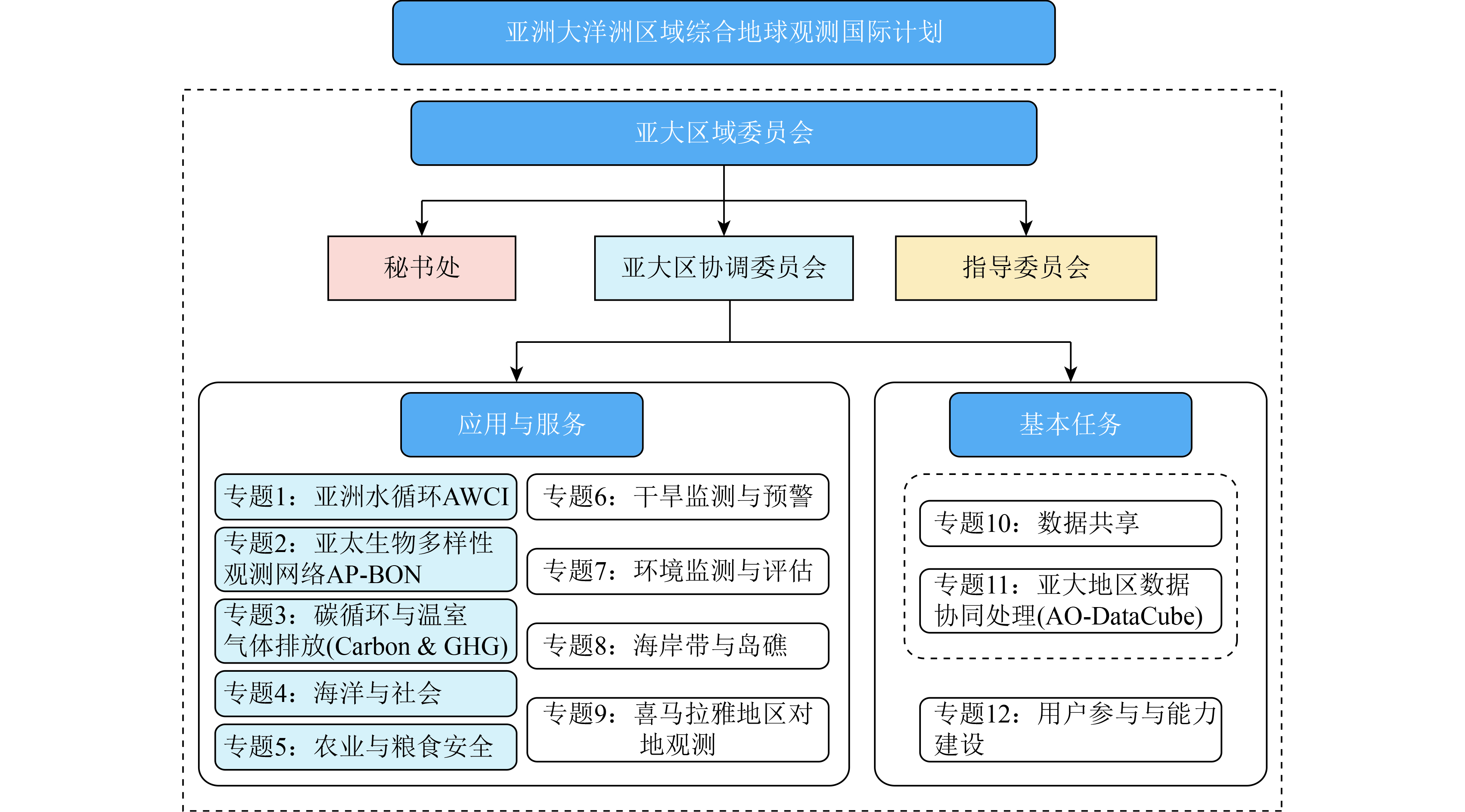
通过GEO国际合作平台,构建亚大区域地球综合观测合作研究网络,突破多源协同定量遥感反演理论和方法,开展碳循环、土地退化、大气污染、海岸带环境等影响区域可持续发展的重大科学问题研究,揭示亚大区域地表辐射与能量平衡、水循环、碳循环以及大气污染的时空分布特征及其与人类活动的互馈机制;建立亚大区域综合地球观测数据分布式处理、定量产品生产与真实性检验平台,促进资源环境与生态保护、防灾减灾与应急响应、社会管理与公共服务、水资源管理、城镇可持续发展等领域的一体化综合研究应用,为“一带一路”倡议的实施提供决策支持,其总体框架如图1所示。
2.3 重点任务
(1) 亚大区域综合地球观测国际合作网络建设。发挥成员国和国际组织在GEO中的各自优势,构建涵盖政策、标准、共性技术、共享与服务及各应用领域的国际合作网络,面向亚太地区开展技术培训,应用案例推广与知识服务;面向中亚、东南亚等“一带一路”沿线区域建设国际综合地球观测技术服务与创新应用基地,提升多领域科技合作与综合应用能力。
(2) 亚大区域地球观测数据处理技术与平台研发。开展综合地球观测数据协同处理与亚大区域产品技术规范研究,推动全系统标准化数据和产品研制;合作开展应用区域的真实性检验和综合实验观测,推动亚大区域共性定量遥感产品反演算法和模型研究,改进精准化技术示范服务能力。
(3) 亚大区域地球观测数据共享服务平台研发。开展多边数据虚拟汇聚机制研究,基于GEO相关技术框架和DAB技术标准,建设区域对地观测大数据云平台,有效组织陆地、气象、海洋等多源卫星遥感数据,汇聚国际地球观测数据资源,研发国际服务门户,为亚大区域各类用户提供数据分发服务。
(4) 亚大区域综合地球观测应用示范。在亚洲水循环、生物多样性与生态系统、碳循环与温室气体排放、海洋、农业与粮食安全、灾害监测、环境、海岛与海岸带、喜马拉雅综合应用等重点应用领域开展专题合作研究与协同创新:
1) 亚洲水循环(AWCI)。利用多源卫星观测数据,开展对多种水循环要素以及水资源的分布、质量和开发利用的联合观测,研究亚洲水循环变化的机理,提升全球和重点区域水资源分布和变化规律的科学认识,减缓与水相关的灾害影响并促进水资源利用的效率。
2) 亚太生物多样性观测(AP-BON)。建立区域生物多样性观测网络,覆盖多个层面的生物多样性和生态系统,观测方法分为遥感、生态过程研究和物种/遗传研究等三个层次,采用定量化的长期观测数据科学评估和预测全球变化条件下生态系统和生物多样性变化,并为相关行动决策提供科学参考。
3) 碳和温室气体监测。通过区域协作建立一个全面的、多方协调的碳和温室气体的跨域观测和分析系统,评估碳循环的变化,了解与人类活动有关的温室气体排放,在GEO的框架内从科学到政策等不同层面上策划和实施战略行动和联合研究。
4) 海洋与社会。通过发展建设区域海洋观测能力,加强对现场和遥感海洋观测数据的整合和获取,优化海洋观测系统设计,促进海洋信息服务的发展,改善海洋观测数据、产品和信息的生产者和提供者与最终用户之间的联系,确保海洋和沿海观测的持续发展和高效利用,以造福社会。
5) 农业与粮食安全。构建区域农业监测和研究国际合作网络,通过技术集成和虚拟协同建立基于卫星和实地观测的业务化农业监测系统,形成区域和全球尺度农作物动态监测和精细评估报告系统,为粮食安全与农业可持续发展提供及时和准确的观测信息、状况评估和发展预测。
6) 亚大区域干旱监测与预警。建立亚大区域国家间利用地球观测技术共同应对旱灾的长期稳定技术协作机制,分析亚大区域干旱发生机制,研发基于多源观测数据的干旱监测技术与方法,开展亚大地区典型干旱事件的应急、监测、评估应用示范。
7) 环境监测与评估。围绕亚大区域社会经济快速发展面临的紧迫环境问题,研究分布式关键环境参量定量遥感产品生产与服务技术,研发亚大区域城市扩展、土地退化、大气污染与生态环境状况遥感综合监测系统,分析评估亚大区域生态环境变化的驱动因素及其变化响应机制。
8) 海岸带与岛礁。与太平洋、印度洋地区相关国家建立亚大区域海洋与岛礁空间观测联合研究网络,发展海洋与岛礁空间信息获取理论与方法,研究全球气候变化背景下区域海洋环境、海岸带和岛礁的变化规律和机理,服务于亚洲-大洋洲沿海国家的海洋可持续发展。
9) 喜马拉雅地区综合地球观测应用。建立喜马拉雅地区的综合观测研究平台,发展地面观测和遥感观测结合的冰雪等喜马拉雅地区典型环境要素监测方法和反演算法,开展联合数据验证,服务区域地质灾害监测、生态环境评估等应用需求。
2.4 管理和运行机制
AOGEOSS鼓励所有亚大区域GEO成员国和参与组织参与该计划,同时欢迎非成员国积极参与。亚大区域委员会是AOGEOSS的决策机构,由亚大区域的GEO成员国代表组成,为实施AOGEOSS计划提供高层次的政策支持和必要的资源。协调委员会接受AOGEOSS联合主席共同领导,由AOGEOSS任务有关的技术和管理专家组成。任务组是AOGEOSS执行实施的基本单元,具体开展区域协调机制下的联合研究与技术合作,加强区域用户参与应用服务。亚大区域综合地球观测国际会议(AOGEOSS conference)和GEOSS亚太地区研讨会(AP-GEOSS)是国际计划实施过程中的重要交流平台,通过区域论坛广泛交流地球观测及其应用方面的科学问题和技术观点,通报AOGEOSS的任务进展情况。
3 计划进展
2015年GEO墨西哥全会前后,亚大区域主要国家开始积极商讨发起亚大区域综合地球观测系统国际计划,经过多轮技术交流和协商沟通,于2016年上半年向GEO秘书处正式提出相关建议。2016年11月,在俄罗斯圣彼得堡举行的GEO第十三次全会上,亚大区域综合地球观测系统国际计划正式宣布启动,得到了与会代表的广泛关注和GEO亚大区域成员国和参与组织的积极反响。
2017年9月,AOGEOSS协调委员会正式成立,由来自中、日、澳、韩等8个国家的12名专家组成。中国联合日本、澳大利亚、韩国等12个亚大区域主要成员国以及联合国亚太经济与社会委员会(UNESCAP)、世界气象组织(WMO)、国际卫星对地观测委员会(CEOS)等13个国际组织共同推动的区域性综合地球观测系统计划进入了新的发展阶段。
目前,AOGEOSS已被地球观测组织作为GEO Initiative纳入GEO 2017年—2019年工作计划,由中、澳、日、韩等4个国家担任共同主席国,中国科学院遥感与数字地球研究所顾行发研究员、国际水灾害与风险管理中心Toshio Koike教授等4位专家担任计划联合主席,并成立了水循环、干旱监测、环境监测评估、海洋与岛礁、数据共享等12个专题任务组,由中方和外方专家共同担任任务组负责人。
在过去的3年间,AOGEOSS先后在北京、圣彼得堡、东京、河内、华盛顿、日内瓦召开多次国际学术研讨和工作会议,开通了中、英、日、韩等多语言版本的网站https://aogeoss.com/cn/ [2018-02-06];研发了旱灾监测与分析平台GDMAP(Global Drought Monitor and Analysis Platform),实现了区域干旱情景在线分析、旱情准实时监测和预警等;整合了多源地球观测数据监测区域生态系统和环境状况变化,并发布了亚大区域光伏发电潜能、生态系统变化、城市扩展等遥感监测数据集;通过数据共享工作组的努力,中国国家综合地球观测数据共享平台(China GEOSS)英文网站于2017年10月24日在第14届GEO全会上开通,正式面向国际社会提供数据共享服务,并在2016年新西兰地震和2017年墨西哥地震、伊拉克—伊朗地震期间发挥了重大作用。Open Data Cube工作组正在进一步落实越南等国的部署任务,并计划在2022年在20个国家推广应用;2017年4月,AOGEOSS中方团队与澳大利亚地球科学局(Geoscience Australia)、联邦科学与工业研究组织(CSIRO)举行AOGEOSS中澳双边会议,就实施中澳地球观测技术合作、推进区域地球观测数据共享、DataCube应用推广以及遥感产品联合验证等达成共识。
本着“国际合作,内外双兴”的原则,充分利用GEO国际资源优势,AOGEOSS多次组织国内专家研讨会,讨论如何建立区域协调的对地观测系统、深化AOGEOSS科学目标、支撑联合国可持续发展及落实未来十年CHINA GEOSS建设规划等议题。作为相关工作的重要成果,国内各领域专家共同编制的《中国面向全球的综合地球观测系统十年执行计划(2016年—2025年)》(英文版)在2017年10月美国华盛顿召开的第十四届GEO全会期间进行了全球发布,取得了积极的国际影响。
4 和其他国际计划的联系
国家级GEOSS的建设是全球GEOSS的建设基础,区域GEOSS在全球尺度、国家尺度的GEOSS建设中具有承上启下的作用,将为发展中国家的政府决策提供更加有效的支持。中国作为发展中国家代表和亚洲及大洋洲地区的GEO轮值主席国,一直积极呼吁共同发展区域综合地球观测系统,提升发展中国家的地球观测能力建设。目前亚洲大洋洲的AOGEOSS、欧洲的EuroGEOSS、非洲的AfriGEOSS、美洲的AmeriGEOSS是区域GEOSS建设的代表。GEO各大区域GEOSS计划各有特点又有所侧重,联合非洲、美洲、欧洲等国家推动区域综合地球观测计划,可进一步提升发展中国家的地球观测与空间技术应用服务能力。
AOGEOSS的框架体系设计可以实现与全球农业和粮食安全监测(GeoGLAM)、全球碳监测(GEO-C)、全球水资源管理、全球生物多样性观测网络(GEO BON)、蓝色星球(Blue Planet)、寒区监测等不同领域、不同层次的地球观测科学计划的衔接互通,在地面观测站网、数据处理系统、区域应用示范等方面鼓励和强化新的能力建设,促进先进技术成果在生物多样性与生态系统、防灾减灾、粮食安全和可持续农业、水资源管理、地球系统科学与全球变化等相关重点领域的应用,为全球和区域可持续发展目标的实现提供科学的决策依据。
5 展 望
可持续发展已经成为全人类的共识。在联合国发布的《改变我们的世界—2030年可持续发展议程》中将加强综合地球观测,促进可持续发展提到了一个新的高度,倡导全球应协力参与,督促世界各国政府在人类和地球至关重要的领域采取行动,在今后15年内落实各项议程,从国家、区域和全球尺度实现可持续发展目标。GEO2015年提出GEO未来十年(2016年—2025年)战略规划,明确了地球观测作为实时信息的价值,可为政府决策制定提供关键数据、信息及知识,为世界各国开展全球综合地球观测体系能力建设提供了重要的发展机遇,是参与全球国际性事务处理的重要舞台。
全球综合地球观测研究和应用是中国国民经济和社会发展全球化的重要支撑。推进地球观测技术国际合作创新,充分利用国际数据、信息和合作资源完善地球信息保障能力,提升国家现代化治理能力,发展全球对地观测战略性新兴产业,积极参与全球治理,为“一带一路”倡议实施提供决策支持,对于提高我国的国际影响力,推动创新性国家建设具有重要的意义。
GEO的第二个十年对于中国来说是非常重要的十年,是中国地球观测能力建设最快和对全球观测需求最旺盛的十年。为支撑国家可持续发展和“一带一路”倡议,落实十九大精神,充分利用GEO平台,结合国家“十三五”规划和《国家民用空间基础设施中长期发展规划》的推进,通过实施亚大区域综合地球观测系统国际计划,发挥中国在观测基础设施、数据共享服务、跨领域综合应用等方面的优势,拓展域内国家在区域性、全球性相关性问题上的技术合作和协同应用,逐步建设完善全球综合地球观测系统,支撑联合国可持续发展目标的实现。
志 谢 亚洲大洋洲区域综合地球观测系统国际计划倡议的提出和发起得到了科技部、国家遥感中心及部际协调小组各成员部门领导和专家的协助与大力支持,同时来自澳大利亚、日本、韩国、印度、尼泊尔、柬埔寨、蒙古国等国家和地球观测组织(GEO)、联合国亚洲及太平洋经济社会委员会(UNESCAP)、世界气象组织(WMO)、国际卫星对地观测委员会(CEOS)、国际山地研究中心(ICIMOD)等国际组织的专家学者提供了帮助和支持, 在此表示衷心的感谢!
1 INTRODUCTION
The Asia–Oceania region accounts for two-thirds of the world’s population and land area. In recent years, rapid socioeconomic development and drastic resource and environmental changes pose a big challenge to the Asia-Oceania society. Complex geography, earthquakes and tsunamis, floods and droughts, environment deterioration and pollution, global warming and island losing, and mountain ecosystem degradation endanger the security of water, food, energy, health, and ecosystem services in the region.
Recognizing that Earth observation data, information, and derived knowledge are critical for identifying vulnerabilities, monitoring and assessing impacts and the uneven development of Asia–Oceania region and complexity of the geographic scope and informing the decision-makers, developing an integrated, shareable, and sustained observation system, and fostering its application capacity are urgently demanded.
Strengthening international cooperation in the field of Earth observation, jointly developing advanced Earth observation technologies, deepening research of earth system science, improving the comprehensive application ability of earth observation system, and addressing growing application demands of various countries in the region on food security, sustainable agriculture, water resource security, disaster warning, ecological environment, major infrastructure construction, and other key areas of society and economy are urgent for Asia–Oceania countries.
Since its establishment in 2005, GEO has devoted itself to establishing a comprehensive, coordinated, and sustainable Global Earth Observation System of Systems (GEOSS), thoroughly understanding the earth system and providing application services for decision-making from observation data to thematic information products.
Based on continuous efforts for enhancing the ability of Earth observations, the Asia-Oceania Caucus members (such as China, Australia, Japan, and Republic of Korea) have realized the value of establishing a regional initiative to work together and the necessity of promoting a regional cooperation with broad user and stakeholder’s involvement to address GEO strategic overall objectives, that is, “Asia–Oceania GEOSS” (hereinafter to be referred as AOGEOSS). Through establishing an effective cooperation framework at national and regional levels and reefing the Asia–Oceania regional organizational network, the AOGEOSS initiative intends to promote the ability of Asia–Oceania countries to confront challenges that pose a risk to the attainment of socially sustainable development goals.
2 OBJECTIVES AND KEY TASKS
2.1 Objectives
The core value of AOGEOSS is to support the sustainable development of Asia–Oceania countries. The actions shall be conducted to achieve the goal of delivering data, information, and knowledge to inform decision-making. To extend the benefits of Earth observation to social-economic development of Asia–Oceania region, the following objectives will guide the implementation of AOGEOSS activities:
(1) Engage with and coordinate all stakeholders, partners, and sponsors working together in Earth observation activities in Asia-Oceania region;
(2) Investigate user needs and address gaps on implementation of GEOSS and develop technological approaches;
(3) Utilize infrastructure, resources, and capacity to develop integrated and sustained observations;
(4) Provide a platform for regional countries to advance data sharing and services;
(5) Establish regional collaboration network by providing technology support and knowledge sharing;
(6) Support decision-making and regional sustainable development with Earth observation information.
AOGEOSS will coordinate various resources, including observations, technologies, and applications, to deliver information services for end-users and facilitate the development of society and the economy of Asia and Oceania. As a key goal of AOGEOSS, promoting further cooperation among countries of Asia–Oceania region, which will facilitate comprehensive understanding for international communities on Earth observation system and a wide range of applications on growing concerns, is essential (Fig. 1).

2.2 Key activities
AOGEOSS initiative will engage participants and stakeholders in Asia–Oceania region and coordinate the observation infrastructure, leveraging the existing cooperation and conducting joint projects under the Asia–Oceania Caucus mechanism of intergovernmental GEO. Priorities will be regional application and services in accordance with regional sustainable issues with increasing concern, including monitoring and evaluation of drought in Asia–Oceania region, environmental monitoring and assessment, coast and island monitoring, and Himalayan GEOSS. Meanwhile, this initiative will also foster the existing activities, such as Asian Water Cycle Initiative (AWCI), Asia-Pacific Biodiversity Observation Network (AP-BON), Asian Rice Crop Estimation and Monitoring (Asia-RICE), Ocean and Society, GEO Carbon, and GHG Initiative. The initiative will also implement data sharing, Asia–Oceania DataCube, and user engagement and communication as foundational tasks (Fig. 2).

2.3 Task groups
(1) Asian Water Cycle Initiative (AWCI). Human factors, such as globalization, population growth, poverty, urbanization, and changes in land use, are aggravating the negative consequences of climatological, hydrological, and meteorological hazards. Extreme climate events are also increasing the water-related disaster risks faced by populations living in vulnerable areas. The losses are growing in developed and developing countries. In this inter-connected world, the impact of an event can immediately cross borders, leading to cascading consequences, even in remote areas from the event. Repeated exposure to disasters is also hampering sustainable development in vulnerable localities.
To address these water-related issues, GEOSS/AWCI, in collaboration with the International Flood Initiative, establish a Platform on Water and Disasters in each member country and launches its activity. The vision of the platform is to envision a future wherein decisions and actions for reducing water-related disaster risks are well supported by coordinated, comprehensive, and sustained risk communication. To realize the vision, the platform strengthens data integration and analysis functions by facilitating data and information accessibility and application to decisions and actions within and across many different stakeholders.
(2) Asia-Pacific biodiversity observation network. Although biodiversity in the Asia-Pacific region is among the highest in the globe with its diverse species and ecosystems spread across terrestrial, marine, and freshwater biomes, it is seriously threatened under land use change, dam construction, sea surface temperature anomalies, and other drivers of biodiversity loss. Since 2009, the Asia-Pacific Biodiversity Observation Network (AP BON) has continued to develop a coordinated Asia-Pacific network that gathers and shares information on biodiversity and ecosystem services. By networking various institutes and biodiversity scientists and collaborating with various bodies of biodiversity observations, including GBIF, GEO BON, ILTER, and IUCN, AP BON continues to contribute to activities for data collection, sharing, analysis, and synthesis integration.
AP BON promoted the five-year (2011—2015) project on “Integrative observations and assessments of Asian biodiversity” sponsored by the Ministry of Environment, Japan. AP BON published three volumes of books on biodiversity observations in the Asia-Pacific region and have been contributing to CBD and IPBES. Moreover, AP BON is currently designing a new work plan, which will include observations of biodiversity/ecosystem changes and their impacts on ecosystem functions by integrating site-based observation network (e.g., forest plot network) and remote sensing.
(3) Carbon and GreenHouse Gas (GHG) monitoring. Carbon and GHG Initiative would provide physical information, such as changes in distributions and fluxes, as well as supporting knowledge for evaluating social impacts associated with emissions reduction, land use change, adaptation, or ocean management efforts. The proposed tasks are as follows:
1) User needs and policy interface: to engage with users and policy makers and ensure the consistency with their evolving needs; to drive the activities of the GEO Carbon and GHG Initiative and address the policy agenda.
2) Data access and availability: to provide long-term, high quality, and open access near-real-time data and data products, complying with the GEOSS principles from a domain-overarching carbon cycle and GHG monitoring system.
3) Optimization of observational networks: to develop and implement on an ongoing basis, a procedure for achieving observations of identified essential carbon cycle variables within user-defined specifications at minimum total cost.
4) Budget calculations and breakdown across scales to inform policy implementation: to develop consistent budgets of GHGs (CO2, CH4, and N2O) from local/urban to global scales using a combination of observations, inventories, models, and data assimilation techniques.
(4) Ocean and society. The task is to target strategy development in synthesizing in-situ open and coastal observational data toward societal uses, such as fishery management, weather and seasonal predictions, and ocean predictions. As the outcome of the 7th GEOSS-AP symposium, the task determined the development of “GEOSS-AP Ocean Data Networking System” through the support of the Blue Planet Initiative and contributions of IOC/WESTPAC. The function of the AP-ONS is to provide a list of observation inventory and the linkages to the data providers in the AP region to determine a solid route for searching in-situ ocean observational data in the AP region. The future task shall be to expand and enhance the function of inventory to access a variety of additional in-situ data in the AP region and strengthen the linkage with one of the global initiatives, namely, Blue Planet Initiative.
(5) Agriculture and food security – Asia Rice. World population, as well as demand for food, have increased linearly over the last 50 years (e.g., In 2008, the price of rice more than doubled in only seven months). In the context of price instability and threatened food security, tools to monitor rice production in real-time are highly needed by governments, traders, and decision-makers because rice is the main crop in Asia (http://www.asia-rice.org[2018-02-06]).
Asian Rice Crop Estimation and Monitoring (Asia-RiCE) is the work of stakeholders to supply rice crop information using Earth observation data in Asia for the development of a component for the GEO Global Agricultural Monitoring (GEOGLAM) initiative. Asia-RiCE promotes the research and operational use of rice monitoring information, including rice crop area estimates/maps, crop calendars/crop growth status, crop damage assessment, agro-meteorological information, and production estimation and forecasting of products derived from Earth observation satellite data-, drone-, and ground-based observation information, statistical information, and crop and climate models. As expected, this task will be implemented with other AOGEOSS tasks and international frameworks, such as Asia Pacific Regional Space Agency Forum, ASEAN-AFSIS, UN-ESCAP, and MRC.
(6) Monitoring and evaluation of drought in the Asia–Oceania region. The frequency, severity, and duration of droughts in the Asia–Oceania region will likely increase in the future due to climate change. The task aims to apply Earth observations and other space-based technologies to provide timely and free access to space-based data/products and services for effective drought monitoring, evaluation, and management. By far, the group has developed a Global Drought Monitor and Analysis Platform (GDMAP), which uses a series of drought indexes based on the multi-source Earth observation data (including remote sensing precipitation, surface temperature, vegetation index, and evapotranspiration) to provide the on-line drought situation analysis, drought quasi real-time monitoring, and early warning. (http://www.droughtmonitor.com.cn/[2018-02-06])
(7) Environment monitoring and assessment. The task proposed herein will mainly focus on the monitoring of the regional land use/cover change, ecological environmental conditions, and atmospheric environmental conditions. The terrestrial ecosystem, important urban ecological environment and development, land transportation system, and solar energy resource in the region are monitored, evaluated, and analyzed using the quantitative remote sensing product datasets based on Multi-source data Synergized Quantitative remote-sensing production system. The reports reveal the regional uneven development and indicate the restrictive factors of different regions.
(8) Coast and island. Coast and island tasks seek to provide an important regional mechanism to address numerous significant issues, including rapid coastal ecosystem (mangroves, seagrass, and coral reefs) loss and unprecedented climate change (e.g., regional climate perturbations, sea level rise, and tsunamis) that risk coastal nations, particularly the many small island developing nations of Oceania, which are subject to rapid sea level rise. Thus, the purpose is to advance and exploit synergies among numerous observational programs devoted to island, coastal, and ocean to improve engagement with a variety of users for enhancing the timeliness, quality, and range of services delivered and raise awareness of the societal benefits of ocean observations at the public and policy levels.
(9) Himalayan GEOSS. Under the AOGEOSS framework, regional Himalayan GEOSS proposed by ICIMOD aims to maximize the benefits of the Earth Observations and Geospatial Information for sustainable mountain development in the Hindu Kush Himalayan Region. The scope of Himalayan GEOSS includes Afghanistan, Bangladesh, Bhutan, China, India, Myanmar, Nepal, and Pakistan, with the efforts from all over the world. The mountain region is already a strong user for the Asia-Pacific regions and will benefit further from the successful coordination of AOGOESS resource, including the satellite, in-situ and assimilation data, infrastructure, and communication platform.
(10) Data sharing Infrastructure. Infrastructure and data services have been regarded as the core of GEOSS. To support regional sustainability and development of regional observing capacity, a data producing and sharing platform should be highlighted by AOGEOSS to improve regional Earth observation data cooperation and ensure the Earth observation data generated in this region or by GEO members and participating organizations in other parts of the world.
(11) AO data Cube. The AO Data Cube aims to develop regional GEOSS dataset to meet the demand of different users from various countries and support the development of standardized product and integrated application of dynamic features of large volumes of Earth observation data. The newly formed Open Data Cube (ODC) community provided a technological solution to eliminate the burden of data preparation.
(12) User engagement and communication. The user engagement and communication task group aims to transfer Earth observation knowledge and technologies to decision-makers, scientific communities, and even civilian user (citizens), which can enhance the capacity building and synergy of partnership with the international and national communities. These aims are realized and promoted through the convening power of the AP Symposium and other dedicated conference and side events. Another important mechanism is to utilize the existing regional and international platforms, such as events that link with the international partners, which include WMO, CEOS, ISPRS, UNESCO, UNESCAP, and POGO.
2.4 Governance structure
(1) Governance principles of AOGEOSS
1) Inclusiveness. All GEO members and participating organizations in the Asia–Oceania Region are encouraged to participate in the structure. Non-member countries are also welcome to participate.
2) Voluntary contributions. All involvement of AOGEOSS activities is conducted on a voluntary basis. All members and partners can take advantage of its strength to achieve the Initiative objectives with joint efforts in line with the implementation plan of the Initiative.
3) Balance. Balance between developed and developing countries, as well as provider communities and user communities, will be considered in the composition of the governance structure.
4) Best efforts. The Initiative should leverage the existing coordination mechanisms to the largest extent possible to achieve Pareto optimality, that is, no one individual country is aggravated in the proposed structure.
(2) Governance structure of AOGEOSS
1) Asia–Oceania Caucus. The Asia–Oceania Caucus is the decision-making body consisting of GEO principals in the Asia–Oceania region. It provides high-level political support and necessary resources to implement the AOGEOSS Initiative.
2) Coordination board. The executive management body, which is co-chaired by the AOGEOSS co-leads, comprises experts on technology and management related to the AOGEOSS tasks.
3) GEOSS Asia-Pacific symposium and AOGEOSS Conference. The regional forum in which broad scientific and technical views on Earth observations and their applications are exchanged and progress of tasks in the AOGEOSS Initiative is reported.
4) Task groups. Task groups are bodies that implement tasks agreed by countries in the Asia-Oceania region or GEO participating organizations.
5) Secretariat. The Secretariat will coordinate and collaborate with AOGEOSS contributors, representatives of users, supporters, and observers, support the Coordination Board, and provide a professional support service to the Task Group.
(3) AOGEOSS initiative co-leads
1) Xingfa Gu (Institute of Remote Sensing and Digital Earth, Chinese Academy of Sciences/China)
2) David Hudson (Geosciences Australia/Australia)
3) Toshio Koike (International Centre for Water Hazard and Risk Management (ICHARM)/Japan)
4) Yongseung Kim (Korea Aerospace Research Institute/Republic of Korea)
AOGEOSS is open to all member states of the United Nation in the Asia-Oceania region and participating organizations of GEO. AOGEOSS also welcomes the active participation of non-member countries.
3 PROGRESS OF AOGEOSS INITIATIVE
During the 2015 GEO Mexico Plenary, Asia–Oceania countries proposed to set up AOGEOSS Initiative and started to discuss the action plan. The proposal for application was also submitted to the GEO Secretariat in the first half of 2016 after many rounds of technical communication and consultation. At the 13th GEO Plenary in St. Petersburg, Russia in November 2016, AOGEOSS was formally launched and was widely regarded and actively responded by member countries in Asia–Oceania and participating organizations of GEO communities. At present, AOGEOSS has been incorporated into the GEO 2017–2019 work plan as a GEO Initiative by GEO. The four experts from Australia, China, Japan, and Republic of Korea are acting as co-leads of initiative.
In September 2017, AOGEOSS Coordination board, which consists of 12 experts from eight countries, such as China, Japan, Australia, and Republic of Korea, was officially set up. The initiatives, which were jointly promoted by 12 major Asia–Oceania member countries, such as Japan, Australia, China, Japan, and Republic of Korea and 13 international organizations, such as the United Nations Economic and Social Commission for Asia and the Pacific (UNESCAP), World Meteorological Organization (WMO), and Committee on Earth Observation Satellites (CEOS), entered a new stage of development.
In the past three years, AOGEOSS international meetings and workshops have been held successively in Beijing, St. Petersburg, Tokyo, Hanoi, Washington and Geneva, and the multilingual website (https://aogeoss.com/en/) built in Chinese, English, Japanese, Korean, and other languages was launched. GDMAP, which realized on-line analysis, quasi real-time drought monitoring, and warning of regional drought, was developed. Multi-source Earth observation data were integrated to monitor regional ecological system and environment changes, and remote-sensing monitoring dataset on photovoltaic power generation of potential ecosystem change and urban growth in Asia–Oceania was published. Data sharing service to the international community from Data Sharing Group played a crucial role during the 2016 New Zealand Earthquake, 2017 Mexico Earthquake, and Iraq–Iran Earthquake.
In April 2017, AOGEOSS Sino-Australia bilateral meeting was held in Sydney. Through the talks, the two sides reached a consensus on implementing Sino-Australian Earth observation technology cooperation, promoting regional Earth observation data sharing, popularizing DataCube applications, and jointly verifying remote sensing products. ODC yields rapid results and has fostered an active and engaged global community of contributors by planning to popularize its application in 20 countries by 2022. The CEOS has been a founding partner in the ODC Initiative. CEOS SEO and CSIRO support the deployment of the Vietnam Data Cube at the Vietnam National Space Agency to develop radar cube technology for the ODC community. The main applications of this technology include rice crops, forest management, and water quality.
4 RELATION WITH OTHER INTERNATIONAL LOOPORATION PROGRAMS
The construction of national-level GEOSS is the basis for global GEOSS construction, while regional GEOSS connects global and national GEOSS construction, providing effective services for developing countries in supporting decision-making. At present, AOGEOSS, EuroGEOSS, AfriGEOSS, and AmeriGEOSS are representative initiatives of regional GEOSS. Each regional GEOSS has its own features and emphasized tasks, thereby uniting with African, American, European, and other countries to promote regional GEO program to further improve developing countries’ Earth observation and space technology application and service capabilities.
Based on the activities and communities established within the Asia–Oceania Regions, the AOGEOSS initiative will foster collaboration and joint activities connected to other GEO activities, such as GEO Biodiversity Observation Network (GEO BON), GEO Global Agricultural Monitoring (GEOGLAM), GEO Water Cycle Integrator, Blue Planet, Global Forest Observation Initiatives (GFOI), GEO Carbon and GHG Initiative, and other global Earth observation science programs.
AOGEOSS plays an important role in supporting sustainable economic development in the Asia–Oceania region, and its goals are highly in accordance with the GEO’s strategic objectives. This Initiative will take full advantage of remote sensing technology, strengthen the data sharing of Earth observation, and enhance data demonstration and application capacity for realizing global and regional sustainable development objectives through integration and innovation of related scientific and technological achievements and the established international coordination mechanism.
5 PROSPECT
Sustainable development has become the consensus of all mankind. Strengthening roles of GEO and promoting Earth observation for sustainable development have been raised to a new height in Transforming our World: The 2030 Agenda for Sustainable Development, which was released by the United Nations.
The “GEO Strategic Plan 2016—2025: Implementing GEOSS” has identified three strategic objectives, namely, “Advocate, ” “Engage, ” and “Deliver” to realize GEO’s vision and maximize the benefits that GEO can bring to users through 2025. The strategic plan has also identified the eight Societal Benefit Areas (SBAs) and their cross-cutting issue, that is, climate change.
The objective of AOGEOSS is to support the GEO members and participating organizations in Asia–Oceania regions to build sustainable and resilient societies through maximum use of the Earth observations by advocating the merits of GEO and GEOSS, engaging researchers, engineers, practitioners, policy makers, civil societies, and private sectors, and delivering data and products obtained by Earth observations. To achieve the three strategic objectives of GEO, the AOGEOSS will build a regional communication and exchange platform to promote discussion and information exchange on cooperation on specific issues and thematic areas related to the SBAs.
China has been actively devoting on building national GEOSS and jointly developing regional GEOSS to improve Earth observation capacity building of developing countries with the extensive involvement of member countries and participating organizations in Asia–Oceania region and global communities. As an integral part of implementing GEOSS, AOGEOSS will coordinate various resources, including observations, technologies, and applications, to deliver information services for end-users and facilitate the development of society and economy of Asia and Oceania.
Acknowledgment Heartfelt thanks to leaders and experts from Group on Earth Observations (GEO), the Ministry of Science and Technology of the People's Republic of China, National Remote Sensing Center of China and various member departments of inter-ministerial coordination groups, as well as colleagues and scholars from Australia, China, Japan, Republic of Korea, India, Nepal, Cambodia, Mongolia, and other countries. Special thanks to the United Nations Economic and Social Commission for Asia and the Pacific (UNESCAP), World Meteorological Organization (WMO), Committee on Earth Observation Satellites (CEOS), International Center for Integrated Mountain Development (ICIMOD), and other international organizations for their assistance and strong support in promoting and implementing the AOGEOSS initiative.
参考文献(References)
-
(GEO Strategic Plan 2016-2025: Implementing GEOSS,(GEO 2016 WORK PROGRAMME Version v4. http://www.earthobservations.org/documents/work_programme/geo_2016_work_programme.pdf)(Group on Earth Observations 10-Year Implementation Plan. Update from the Implementation Plan Task group (IPTG), 33rd Executive Committee 2015. http://www.earthobservations.org/documents/10-Year%20Plan%20Reference%20Document.pdf)Li M X and Zhang S M. 2009. Analysis on status and trend of international cooperation in earth observation area and the enlightenment to China. Remote Sensing Information, 2 : 110–113.Gu X F, Yu T, Gao J, Tian G L, Wang C M, Zheng F J, Li J, Dong W, Mi X F, Hu X L, Xie Y, Meng Q Y, Liu Q Y, Yang J, Wei Z, Zhang Z w, FANG Li, Lin Y H, Gao H L, Zhao L m, Zheng L J, Liu M, Li L L, Sun Y, Cheng Y, Zhang Y Z, Huang X Z, Zang W Q, Xu H, Wu Y, Liu P, Liu D H, Deng A J. 2016. Application-oriented scientific demonstration research for spaceborne remote sensing. Journal of Remote Sensing, 20 (5): 807–826. [DOI: 10.11834/jrs.20166209]Gu X F, Yu T, Gao J, Tian G L, Zhou S Y, Wei C J, Li J, Yu Q, Liu D H, W Z, Meng Q Y, Xu H, Guo H, Zhou X, Wang C M, Zang W Q, Huang X Z, Gao H L, Zheng F J, Liu M, Wang D, Zhao Y M, Wei X Q, Sun Y, Li B, Liao J, Ren X Y. 2016. Up to the higher altitude-the new " three campaigns” for the development of China spaceborne remote sensing application. Journal of Remote Sensing, 20 (5): 781–793. [DOI: 10.11834/jrs.20166244]GEO Strategic Plan 2016-2025: Implementing GEOSS, http://www.earthobservations.org/documents/GEO_Strategic_Plan_2016_2025_Implementing_GEOSS_Reference_Document.pdfGEO 2016 WORK PROGRAMME Version v4. http://www.earthobservations.org/documents/work_programme/geo_2016_work_programme.pdfGroup on Earth Observations 10-Year Implementation Plan. Update from the Implementation Plan Task group (IPTG), 33rd Executive Committee 2015. http://www.earthobservations.org/documents/10-Year%20Plan%20Reference%20Document.pdf( 李梦学, 张松梅. 2009. 地球观测领域国际科技合作现状、趋势及启示. 遥感信息, 2 : 110–113. [DOI: 10.3969/j.issn.1000-3177.2009.02.022] )( 顾行发, 余涛, 高军, 田国良, 王春梅, 郑逢杰, 李娟, 董文, 米晓飞, 胡新礼, 谢勇, 孟庆岩, 刘其悦, 杨健, 卫征, 张周威, 方莉, 林英豪, 高海亮, 赵利民, 郑利娟, 刘苗, 李玲玲, 孙源, 程洋, 张雅洲, 黄祥志, 臧文乾, 徐辉, 吴俣, 柳鹏, 刘东晖, 邓安健. 2016. 面向应用的航天遥感科学论证研究. 遥感学报, 20 (5): 807–826. [DOI: 10.11834/jrs.20166209] )( 顾行发, 余涛, 田国良, 周上益, 魏成阶, 李娟, 余琦, 刘东晖, 卫征, 孟庆岩, 徐辉, 郭红, 周翔, 王春梅, 臧文乾, 黄祥志, 高海亮, 郑逢杰, 刘苗, 王栋, 赵亚萌, 魏香琴, 孙源, 李斌, 廖戬, 任芯雨. 2016. 40年的跨越—中国航天遥感蓬勃发展中的" 三大战役”. 遥感学报, 20 (5): 781–793. [DOI: 10.11834/jrs.20166244] )


