收稿日期: 2016-09-20
2. National Satellite Meteorological Centre,Beijing 100101, China
3. Beijing PiesatInformation Company, Beijing 100195, China
进入21世纪以来,地球再次进入了地震活跃期,重大地震发生次数明显高于历年平均数( Gerstenberger 等,2005)。“9·11恐怖袭击事件”以后,恐怖袭击活动在世界各地屡屡发生,中国新疆喀什地区也成为暴恐破坏活动的重灾区。随着气候变化加剧,极热极冷极旱极涝等极端天气频繁出现( Min 等,2011),或将对2022冬奥会产生不确定影响,异常天气的早期预警和正确应对,以及所有运动场地的安全保障对于保障国家安全、维护国家形象至关重要。而电网、交通与通信设施,极易在地震、恐怖袭击中遭到破坏,也是冬奥会能否正常进行的重要保障。
在这一复杂背景下,国家重点研发计划支持的“天空地协同遥感监测精准应急服务体系构建与示范”项目(2016YFB0502500)于2016年7月立项。该项目以中国科学院遥感与数字地球研究所为依托单位,联合国内相关领域的优势科研院所、高校、企业等共计12家单位,将围绕4类在自然灾害、社会事件、重大社会活动、生命线工程中最具代表性的应急服务需求,以遥感技术为核心,协同多种空间信息技术,研究天空地协同遥感监测应急服务标准与规范,突破天空地一体化协同观测、数据聚合分析和精准信息提取技术,构建应急服务与指挥调度平台,开展“一带一路”沿线、境外及敏感区域突发事件精准应急服务示范。
2、 研究现状随着对地观测技术的快速发展,以及云计算、物联网、大数据等新技术的涌现,协同遥感监测在应对处置重大突发事件中发挥着越来越重要的作用。国际上,为应对突发事件建立了若干个应急体系,如美国联邦应急管理署FEMA(Federal Emergency Management Agency)、加拿大全球危机紧急管理网络和日本灾害应变系统,积极推进天空地一体化应急体系跨越发展。中国高度重视并制定了一系列计划,但与国际领先水平相比,尚有一定差距。
防灾减灾方面,2012年中国气象局负责承建的国家突发公共事件预警信息发布系统,是国务院应急平台主要的突发公共事件预警信息权威发布系统( Pei 等,2012)。国家减灾委员会、测绘地理信息局、水利部、气象局、农业部等部门已根据各自需要,建立了地震、洪涝、气象、农业灾害监测及综合防灾减灾系统( 国防科工局 等,2013)。中国科学院遥感与数字地球研究所基于数字地球科学平台,集成开发了突发事件遥感监测与网络服务平台,可对地震、洪涝、干旱、沙尘暴、林火等主要灾害进行持续监测评估,已形成了对多种重大突发事件的遥感监测能力,正在逐步推进应急协同监测与评估体系的建设。
反恐方面,美国采取举国机制、全球战略和联合作战,由国家安全委员会统筹调度( 季晓丹和王维,2011)。中国正在运行和建设各级反恐应急指挥平台,但对于野外应急复杂条件下反恐突击作战尚存在数据保障能力薄弱、指挥控制实时性不强和精准定位跟踪功能缺乏等问题。需要针对“一带一路”敏感地区反恐实战迫切需求,实现具备战场环境快速重建、态势实时感知、重点目标动态跟踪功能的反恐应急指挥平台,提高联合作战能力。
气象应急保障方面,欧美等国取得了一些突破性进展( Kim 等,2014)。中国在各种数值模式使用、多种资料融合同化等方面开展了大量工作,但在多源遥感资料融合应用方面还不能满足气象应急服务需要。急需针对冬奥会气象与安全应急保障,建设适用于中国业务系统环境的多源数据3维大气融合系统。
电网应急方面,美国电力科学研究院提出将遥感技术引入电网应急救援现场,建立了电力应急系统解决方案( Cornelius 等,2013)。随着“一带一路”和全球能源互联战略的实施,中国电网跨越范围愈加广泛,途经地区环境恶劣,气象条件复杂,极易受到地震等自然灾害及暴恐等人为破坏的影响,引发大面积断电等重大事故,对社会经济造成巨大影响( Wang,2015)。因此,急需通过研究电网突发事件发生、发展规律,构建应急服务与指挥决策系统。
可见,针对重点区域典型突发事件精准应急服务、指挥调度中存在的问题,研究区域天空地协同遥感监测与应急服务技术体系,提高重大突发事件处置决策能力,是未来的重要发展趋势。
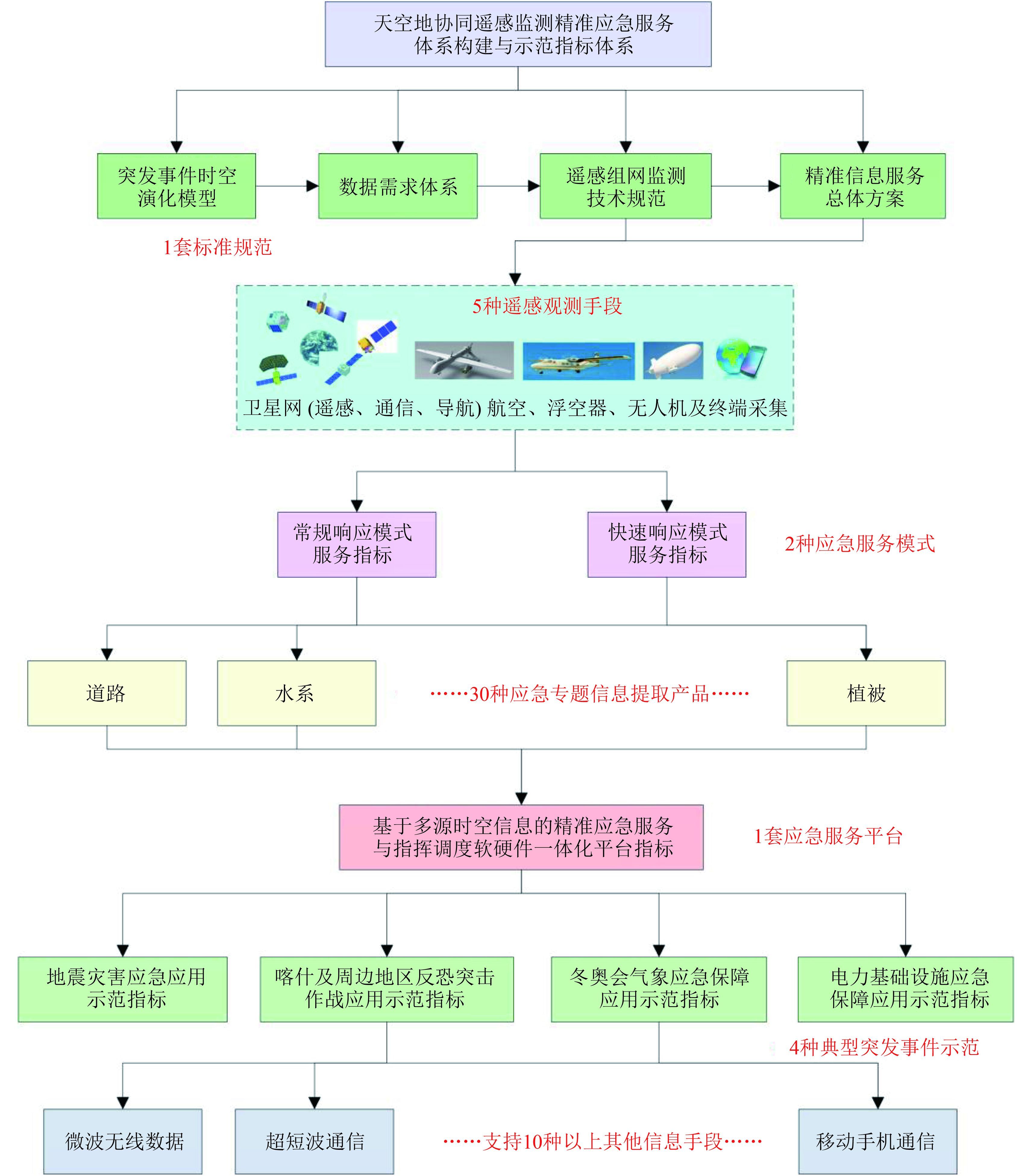
3、 研究目标项目将围绕地震灾害、暴恐事件、冬奥会和电网应急保障4种应急服务需求,以遥感技术为核心,协同多种空间信息技术,研究天空地协同遥感监测应急服务标准与规范,突破天空地一体化协同观测、数据聚合分析和精准信息提取技术,构建应急服务与指挥调度平台,开展重点敏感区域的突发事件应急服务示范 (图1)。

|
| 图 1 指标体系图 Figure 1 Frame and the index system of the project |
项目根据应急监测的具体需求拟定了7类200多项指标,核心指标包括1套总体方案与标准规范,5种以上遥感手段,2种应急响应服务模式,30种以上应急信息产品,10种以上通信手段。按时间轴划分,5 min内规划30颗卫星数据获取计划,厘米级的地面移动终端响应时间小于10 min,浮空器响应时间小于20 min,长航时无人机巡航时间大于24 h,卫星响应时间小于100 min,将大幅提高应急服务的时效性。
4、 研究内容与方法 (4.1) 研究内容项目将围绕地震灾害监测与评估、暴力恐怖事件应急处置、北京冬奥会气象与安全应急保障,以及电力、通信、交通等国家重大基础设施监控与修复等多种应急服务需求,重点解决如何有效利用云平台、大数据与数字地球等现代信息技术,聚合分析天空地多源多维异构数据,实现精准应急服务与指挥决策的关键科学问题,并分列4个课题,着重开展如下6方面的研究内容:
(1) 研究突发事件演化过程与机理,构建突发事件应对总体方案;
(2) 研究区域应急响应天空地组网遥感监测应急服务体制机制,建立应急服务标准规范;
(3) 研究针对应急响应的多平台协同观测方法,构建实战化区域空间信息应急数据传输链;
(4) 突破天空地一体化空间数据快速处理、应急信息提取与定制服务关键技术;
(5) 构建可扩展的集成遥感、通信与导航技术的精准应急服务与指挥调度平台;
(6) 开展精准应急服务定制与指挥实战型应用示范。
通过研究,将实现突发事件信息协同机制理论与理念的创新,以改变以往粗放、漫灌式的信息服务;实现精准应急服务技术体系的创新,重点突破多平台数据协同观测、空间数据快速处理、应急信息快速提取与定制服务中的一系列关键技术;实现时空一致性、序贯性数据获取和信息聚合的创新,解决多源应急信息彼此孤立、割裂的难题。
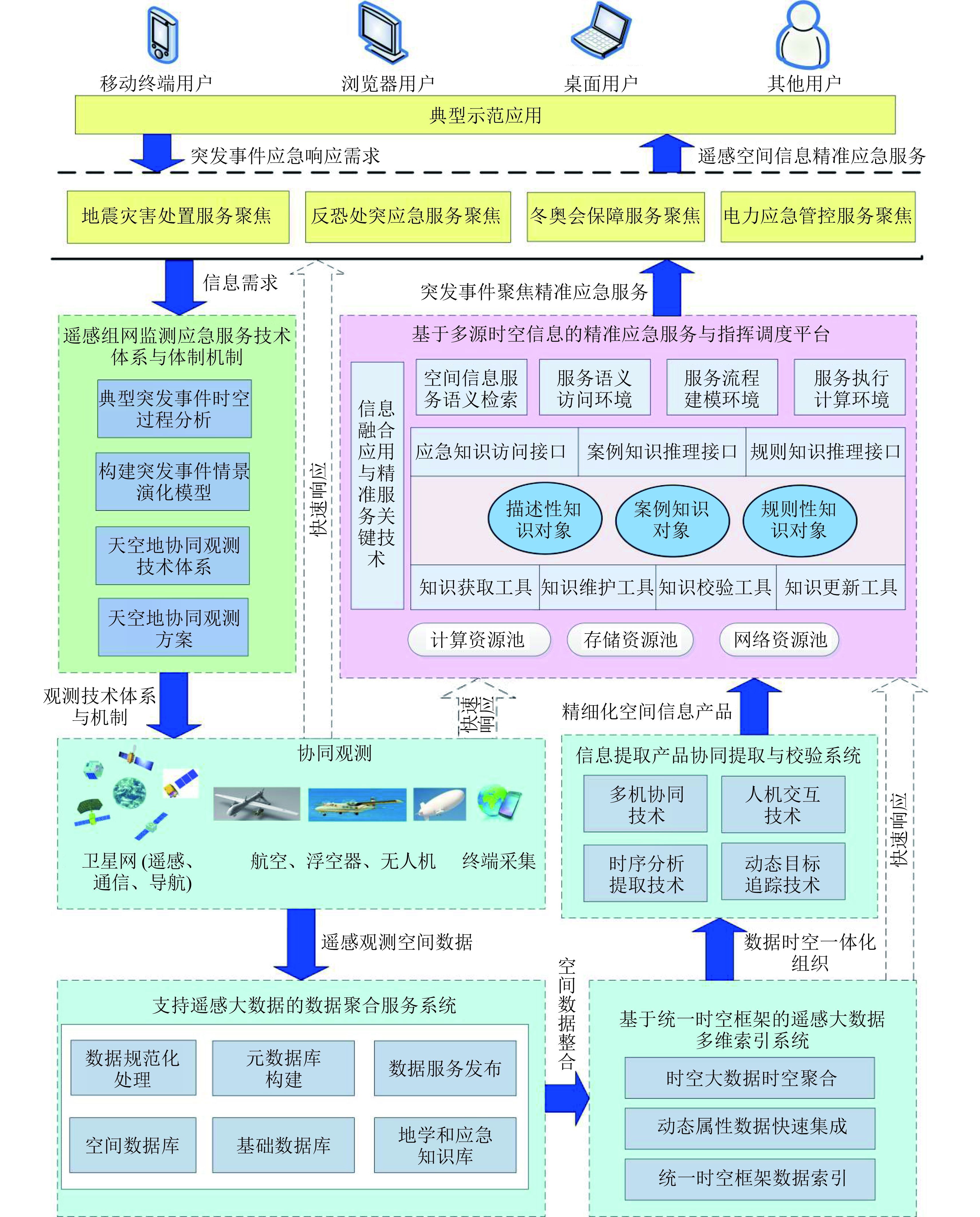
(4.2) 方法与技术路线如何应对重大突发事件,是世界上许多国家都面临的棘手问题。为此,发达国家建立了各自的应急体系,中国相关部门和地方政府也有相应的应急体系,并制订了相关的规划。然而,突发事件复杂多样,而以往的应急信息服务过于粗放,所以,急需建立天空地协同的精准应急服务技术体系。 图2给出了“天空地协同遥感监测精准应急服务体系构建与示范”项目的技术路线。

|
| 图 2 项目技术路线 Figure 2 The overall methodology of the project |
一旦6级以上地震、恐怖袭击、异常天气事件发生,或电网受到破坏,立即启动应急响应,根据突发事件的性质、地点、需求的不同,下达各种遥感数据、定位导航、地面终端及其他空间信息获取与收集指令,开启应急通信频道。地震破坏影响面大,且震后往往天气恶劣,故以卫星数据为主,特别是SAR数据。同时,立即启动飞机奔赴灾区。而反恐作战,目标在于锁定人,以无人机和通信侦听手段为主,辅以高分辨率遥感和红外遥感数据,开展反恐作战与恐怖分子追捕信息支援。冬奥会场所固定,以浮空器为主,辅以气象卫星、高分分辨率卫星、定位导航、地面终端、通信支持。在以上3项突发事件应对中,电力系统、交通、通信设施都是监测重点之一。天空地一体化的空间信息获取后,通过数据聚合服务系统,进入信息提取系统,然后通过指挥调度平台提供给应对突发事件的一线指战员使用。
5、 预期效益项目完成后,将有效实现天空地各类信息资源的高效利用,精准跟踪、预测突发事件发生、发展的全过程,解决突发事件监测数据获取时效性差、数据整合与集成困难、数据应用共享与服务能力弱等问题,大幅提高精准应急服务与指挥决策水平。项目成果将用于中巴经济走廊特高压线路,甚至中哈、中俄特高压线路的安全保障与修复,创造数亿元的经济效益;同时,精准应急服务将显著减少人民生命财产损失,提高对恐怖分子的打击准确度,有效应对冬奥会异常天气、保障安全,减少突发事件对中巴经济走廊电网的威胁。此外,平台建设涉及的各项技术有利于促进我国航天、航空、通信、定位等技术的进步,刺激和带动相关领域科学技术的发展。项目将通过区域示范推动“一带一路”部署,促进沿线各国经济繁荣与社会稳定,提升中国在重大突发事件处置中的影响力和话语权。
6、 结 论重大突发事件的应对与处理是各个国家面临的棘手问题,而现有的应急信息服务过于粗放,急需建立天空地协同的精准应急服务技术体系。在国家重点研发计划的支持下,“天空地协同遥感监测精准应急服务体系构建与示范”项目将通过3年的攻关,以精准应急信息推送为驱动,打破“海量信息漫灌,应用端甄别”的现状,建立“体系机制—数据获取—信息提取—多维聚合—服务定制推送—实战示范检校”一体化的链路,为中国“一带一路”、边境口岸等重点敏感区域的突发事件应急决策提供重要的技术支撑。
| [1] | Cornelius S P, Kath W L, Motter A E. Realistic control of network dynamics[J]. Nature Communications, 2013, 4 : 1942 . DOI: 10.1038/ncomms2939 |
| [2] | Gerstenberger M C, Wiemer S, Jones L M, Reasenberg P A. Real-time forecasts of tomorrow’s earthquakes in California[J]. Nature, 2005, 435 : 328 –331. DOI: 10.1038/nature03622 |
| [3] | 季晓丹, 王维. 美国海洋安全战略: 历史演变及发展特点[J]. 世界经济与政治论坛, 2011 : 69 –84. Ji X D, Wang W. Marine security strategy in the United States: historical evolution and development characteristics[J]. Forum of World Economics and Politics, 2011 : 69 –84. |
| [4] | Kim Y J, Marshall W, Pal I. Assessment of infrastructure devastated by extreme floods: a case study from Colorado, USA[J]. Civil Engineering, 2014, 167 : 186 –191. DOI: 10.1680/cien.14.00032 |
| [5] | Min S K, Zhang X B, Zwiers F W, Hegerl G C. Human contribution to more-intense precipitation extremes[J]. Nature, 2011, 470 : 378 –381. DOI: 10.1038/nature09763 |
| [6] | 裴顺强, 孙健, 廖旭明, 李欣. 国家突发事件预警信息发布系统设计[J]. 中国应急管理, 2012 : 32 –35. Pei S Q, Sun J, Liao X M, Li X. Design of national emergency early warning information release system[J]. China Emergency Management, 2012 : 32 –35. |
| [7] | State Administration of Science, Technology and Industry for National Defense, and Institute of Remote Sensing and Digital Earth, Chinese Academy of Sciences. 2013. Implementation plan for national natural disaster spatial information infrastructure program (2013. 3), in: Medium- and long- term development plan of national civilian space infrastructure (2015-2025)国防科工局, 中国科学院遥感与数字地球研究所等. 2013. 《国家自然灾害空间信息基础设施专项实施方案(2013. 3)》, 列入《国家民用空间基础设施中长期发展规划(2015-2025年)》(请核对本条文献信息) |
| [8] | 王志轩. "一带一路"电力企业的机遇与挑战[J]. 中国能源, 2015, 37 : 9 –12. Wang Z X. Opportunities and challenges of the one belt and one road initiative to electric power enterprises[J]. Energy of China, 2015, 37 : 9 –12. DOI: 10.3969/j.issn.1003-2355.2015.10.002 |

