

|
收稿日期: 2016-05-24; 修改日期: 2016-06-21;
优先数字出版日期: 2016-09-25
基金项目: 国家重点基础研究发展计划(973计划)(编号:2015CB954103);中央高校基本科研业务费专项资金资助(编号:2652015339);中国博士后科学基金资助项目(编号:2016M590117)
第一作者简介:
林珲(1954-), 男, 教授, 研究方向为虚拟地理环境、空间综合人文学等。E-mail:huilin@cuhk.edu.hk
通讯作者简介: 张春晓(1984-), 女, 讲师, 研究方向为虚拟地理环境、尺度适宜性。E-mail:zhangcx0@gmail.com
中图分类号: P208
文献标识码: A
文章编号: 1007-4619(2016)05-1290-09
|
摘要
地理知识是通过对地理科学领域独特的背景、过程和结果进行解释而得到的知识。如何有效表达和共享地理知识是地理学研究和应用中的重要问题。本文首先将地理知识划分为3个层次,事实型知识、规则及控制型知识和决策型知识,分析了不同阶段地理语言对地理知识表达与共享的支持能力。对比地图和GIS语言,发现新一代地理语言-虚拟地理环境VGEs(Virtual Geographic Environments)能够较为全面地支持3个层次的地理知识。针对VGEs,从多个角度分析了其服务于地理知识表达与共享的能力,包括虚实结合理论、地理模型库及管理系统、动态可视化表达和异地协同工作环境。结合面向珠江三角洲地区空气质量研究问题的虚拟地理环境平台,对上述各方面进行了阐述。最后从地理知识生成、管理与应用角度对未来研究提出展望。
关键词
地理知识 , 地理语言 , 虚拟地理环境 , 知识分享
Abstract
Geographic knowledge, which is the higher level of geographic information, is acquired on the basis of geographic background, process, and results. The expression and sharing of geographic knowledge is important in many applications for urban and environmental planning and for any application in territorial intelligence. Expressing and sharing geographic knowledge is a significant issue in current geographic research. This paper is based on the evolution of geographic language from maps to geographic information system (GIS) and virtual geographic environments (VGEs). It aims to review the capability of VGEs to support geographic knowledge expression and sharing. To investigate the characteristics of different geographic languages and thusexpress and share geographic knowledge, we divided geographic knowledge into three levels:factual knowledge, rules and control knowledge, and decision-oriented knowledge. The evolution of geographic languages and their capability to support geographic knowledge expression and sharing were reviewed by discussing the relationship between geographic world, geographic language, and geographic knowledge. VGEs have more power to support geographic knowledge expression and sharing compared with maps and GIS. The outstanding features of such new generation of geographic language were reviewed considering their contributions to geographic knowledge expression and sharing. The features include interactive visualization, multi-channel perception, virtual reality technology, model base and model management, and spatially distributed collaboration. 1. Interactive visualization, multi-channel perception, and virtual reality technology enhance the expression of geographic world and geographic knowledge. The distance between geographic knowledge "writer" and "reader" is shortened. Thus, reaching a consensus on the expression and understanding of geographic knowledge becomes easy. Users in this virtual environment, which is the counterpart of the geographic world, can easily share geographic knowledge, unlike in traditional maps or dimension-reduced GIS. 2. Two cores of VGEs, data base and model base, are helpful in expressing and reusing geographic knowledge. Model base, which includes statistical models and dynamic geographic models, is the output from geographic facts and rules. Such geographic knowledge can be accumulated and reused by different users through an integrated model base. Users can analyze and simulate geographic phenomenon and process and acquire a high level of geographic knowledge to manage the geographic world. 3. Geo-spatial collaboration is developed in VGEs to support experts from multiple, spatially distributed disciplines and allow these experts to collaborate in conducting geographic simulation and analysis. In this way, they can share knowledge and obtain scientific cognition of the geographic world. Air quality problem is a crucial issue for the government of Hong Kong and the Pearl River Delta region. Thus, a VGE platform is developed for users from multiple disciplines to conduct air quality simulation and visual analysis by coupling meteorological and air quality models. In multiple perspectives, this case study analyzed the capability of VGEs in expressing and sharing geographic knowledge, with VGEs including virtual reality technology, geographic model base and management system, dynamic visualization, and geo-spatial collaboration technology. VGEs are under development and face key challenging issues. This paper is concluded with a discussion on future research concerning geographic knowledge creation, management, and application.
Key words
geographic knowledge , geographic language , virtual geographic environments , knowledge sharing
1 引言
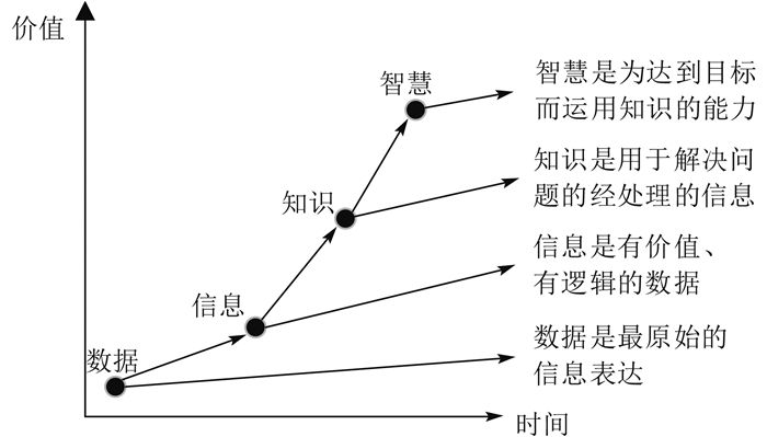
地理环境是人们赖以生存的环境,是一个复杂的巨系统,其中的地理实体不仅种类和数量众多、不断变化,而且相互关系也错综复杂(郑新奇,2012;Goodchild,2015)。人类在不断探索、利用和改造周围环境过程中,产生了海量的空间数据、信息和知识(林珲等,2003)。随着数据和信息的发展,特别是大数据时代的到来,作为基于海量地理数据和地理信息基础上产生的高层次的地理价值(Rowley,2007)(图 1),地理知识的表达和共享越来越受到关注(陈虎等,2011;王富强,2013;Nissen等,2014;林珲和游兰,2015)。例如,有学者对地理知识表达展开研究,尝试将关于地理世界的事实、关系、过程等编码成为一种合适的数据结构,实现存储、管理与共享(甘莉等,2006);Thiele和Grimm(2015)则尝试通过重现、分解并改进已有的生态模型来产生和共享通用性的地理知识。

对于地理知识,不同学者从多个角度对其进行认识(马蔼乃,2001;龚建华等,2008;陈虎等,2011;Laurini,2014)。按知识的等级和地理知识库中的应用(Huang和Deng,2009),可将地理知识分为以下3个层次:
第1层次:事实型知识,即人们可以直接获得的知识,是知识库中最基本的知识单元。一般指地理学中单要素因子,是一种静态的知识,如植被覆盖度、坡度、土层厚度、降雨强度等。
第2层次:规则及控制型知识,指地理学基本原理及地理专家经验,是构成推理机的基本规则。这部分知识是处理相关问题时与事物的行为和判断相关联的知识,是人们进行决策和规划的依据,是一种兼有静态与动态的模型化知识,如植被分布与海拔的关系、降雨对空气中PM2.5的湿沉降作用。人们往往利用这种知识来判断和推导隐含的知识并求解问题。
第3层次:决策型知识,即进行规划、决策的经验性知识,是地理学专家长期实践经验的总结,是根据推理规则得出的最终决策知识,如减少一定规模的生产和交通污染物排放对空气质量改善的预期影响。
地理知识的表达与共享是发挥地理知识价值最大化的有效途径,为知识的运用和地理智慧的发展提供有益积累(储节旺和方千平,2007;Lin等,2013b;Pinjani和Palvia,2013)。在人类认知、理解、表达与共享地理知识的过程中需要一种地理语言,一种能够在人们之间便于交流和传递地理知识的语言。地理语言即是人类理解、表达、共享地理知识的重要工具,其演变与发展突出体现在功能扩展和形式的变化上,在相当程度上受人类观测手段和认识水平的影响(胡最等,2012)。
围绕地理语言,学者们讨论了其从地图、GIS到虚拟地理环境VGEs的演变历程,主要特点与功能(林珲等,2003;胡最等,2012;Lin等,2013a;张春晓等,2014),而VGEs作为新一代地理语言愈来愈在地理环境模拟分析、复杂地理问题求解等方面发挥着重要作用(Chen等,2015),因此,深入探讨VGEs对地理知识表达与共享的支撑作用有助于推动地理语言的发展,加强地理知识的应用。基于近些年来VGEs理论方法和实践应用的发展,林珲和游兰(2015)针对地理知识,分析了VGEs地理知识工程的特点、机理及关键技术,但总体上仍处于初步认识阶段。本文以多层次地理知识为基础,结合地理语言的发展,探讨了VGEs对地理知识表达与共享的特点,指出当前地理语言的不足和可能的发展方向,加固走向地理智慧的重要一环。
2 地理知识与地理语言
2.1 地理知识的表达与共享
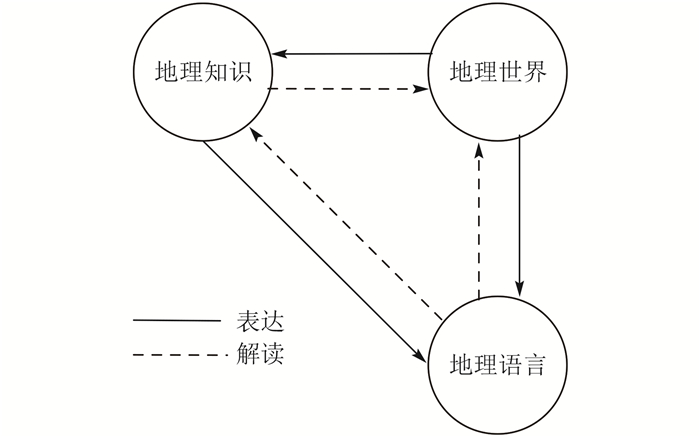
地理知识的表达是应用地理语言对现实地理世界的表达(Celentano和Pittarello,2012)。地理知识、现实地理世界与地理语言三者的关系如图 2所示。地理语言是对现实地理世界和已有地理知识的表达,也即地理语言的“写”功能。而地理知识正是对地理语言表达的解读,并服务于地理世界的认知与管理,也即地理语言的“读”功能(王家耀和陈毓芬,2000)。随着人类对地理世界认识的加深,地理知识不断丰富,这对地理语言也提出新的挑战和机遇;同时,随着地理语言的发展,对地理世界的表达和共享能力不断提高,也加强了人类对地理知识的积累和应用。
2.2 地理语言的发展
有别于一般的文字表达和语言交流,地图是被普遍认可的最朴素的地理语言。自1954年提出“地图的语言”以来,地图语言的相关研究迅速兴起(Blaut,1954;胡最和闫浩文,2008),地图也被认为是第一代地理语言(林珲等,2003;Celentano和Pittarello,2012)。通过地图,人们可以很方便地与他人交流和分享空间位置相关的信息,比如分享一个地点在地球上的位置、从A点到B点的路线等(Morrison等,2011;Celentano和Pittarello,2012)。地图也可以清楚高效地描述一个区域的降水、地形、土地覆盖分布等地理事实型知识,便于人们理解与共享所描述的地理知识(Arciniegas和Janssen,2012)。
随着人类科技的进步,地理语言也在演化、发展(图 3)。为了便于地图的制作和出版,基于计算机信息科学技术,GIS应运而生。而GIS的发展又提供了更为丰富的地理知识生成、表达和共享能力,主要表现在空间数据库技术、拓扑分析和空间统计分析功能(Celentano和Pittarello,2012)。特别是近年来,随着模型库、虚拟现实、多通道感知以及地理协同等理论与技术的发展,新一代地理语言—VGEs为人类提供了更为逼真的地理知识平台;同时也丰富了地理语言的内涵,扩展了其框架(林珲等,2003;Chen等,2013;Zhang等,2016)。
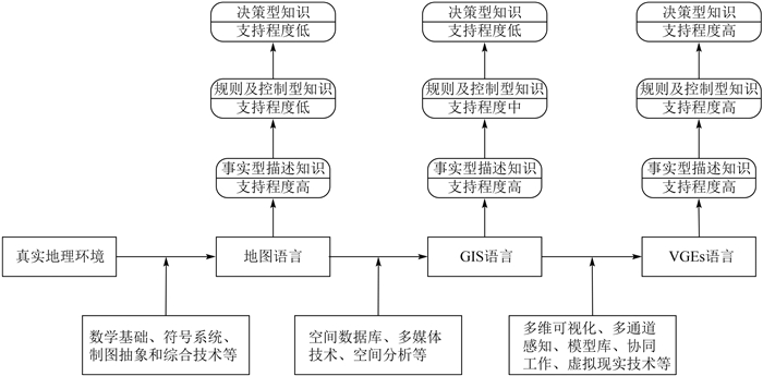
地理语言的发展对3个层次地理知识表达和共享的支持程度也在逐步提高。概括来讲,地图语言对事实型描述知识支持程度较高,但对第2层次和第3层次地理知识的表达与共享支持有限;而经过GIS的发展,VGEs可以较为全面地支持3个层次的地理知识(图 3)。
3 基于VGEs的地理知识表达与共享
VGEs是GIS地理语言在智能化、网络化和虚拟现实表现等方面向前发展的更高级形式。首先,作为地理语言,VGEs的交互式可视化表达和多通道感知能力得到加强,支持用户对3维地理现象的剖面分析、时间维度的快捷交互、气味与温度等感知(Zhang等,2015,2016)。这拉近了地理世界表达的“制图者”和“读图者”之间的距离,即地理世界的表达与解读趋于统一,所以用户在生成对现实世界表达的同时,也在对所生成的表达内容进行认知理解(Ardito等,2012),甚至合二为一。因此,人们对地理知识的理解更加一致(Chen等,2011,2013)。同时,VGEs中引入虚拟现实技术(virtual reality)亦有助于拉近表达的地理世界与现实世界的距离,如传感器的接入、沉浸式感知装备等技术和设备使得基于VGEs的表达和感知更加逼真,同时也使语音等多种表达方式在地理知识分享中的作用得以体现,而这是对以图形图像类为主的地理知识分享方法和手段的重要补充(龚建华等,2008)。
地理知识共享的基础就是对地理知识的表达、存储和管理。而以双核(模型库和数据库)为主要特点的VGEs,其对地理知识的描述和分享能力大大加强(Xu等,2011)。地理模型(统计模型、动力学模型、多智能体模型等)是人类对地理环境发展历程和变化规律的长期积累和不断完善的成果,也是支持决策的重要组成部分(Iyer等,2005;Rollins等,2014)。从地图到GIS到VGEs,地理模型在地理语言中从无到有、从辅助模块到核心模块,这是随着人类对地理环境认知深入所带来的必要结果,这也表明地理语言与人类认知地理环境的相互促进、共同发展(Lin等,2015)。同时,研究学者基于模型与数据的类比性(Dolk,1986;Tsai,2001;Iyer等,2005;Rollins等,2014),指出了地学模型在地理问题求解中的意义,提出了模型库及模型管理系统(model base management system)的理论方法(黄雪芹,2008;郑新奇,2012;张耀南等,2013;Zhang等,2015,2016)。模型库与数据库的相似之处在于对模型的管理和共享,即通过对多领域、多尺度模型进行解析、封装、集成和运行,使得基于模型的地理知识得以更好地表达与共享;模型库比数据库更为复杂的是它对模拟过程的管理,包括模型运行环境以及应用模型进行模拟分析时模型输入数据、参数设置和模拟输出,加强模型模拟结果的可重复性、可验证性和基于模拟分析获得地理知识的可追踪性和共识性,进而提高对已有地理知识的继承和共享(赵国辉等,2013;Rollins等,2014;Seagren,2015;Thiele和Grimm,2015;Yue等,2015)。所以基于模型库的VGEs相对于GIS可以有效支持第一、二层次地理知识的表达和共享,还可以支持基于模拟模型的决策分析。
异地协作功能的提供,使得基于VGEs的地理环境模拟和分析的交互性有了质的飞跃。作为Web GIS的进一步发展,基于协同式VGEs,通过网络,不同地方、不同背景的人可以协同工作、进行交流沟通(刘锐和杨卫军,2009;Lü,2011;Xu等,2011),为地理知识共享和地理实验研究提供有效平台(Yang等,2009)。例如城市扩张、气象变化和空气质量的专家都可以协同地对地理环境展开模拟分析,他们的知识也得到共享,使得地理环境系统模拟的可靠性有效加强(Lin等,2013b;张春晓等,2014);同时,基于协同工作平台,不同角色的参与人员,包括政府人员、私人团体都可以从各自的价值和目的出发,参与地理问题的需求定义、求解、决策过程(Schmidt,2008;Van Der Wal等,2008;Nissen等,2014)。在VGEs中,参与者不仅可以获取不同类型、不同地域的知识,而且能够在平等的层面上为知识生产做贡献,建设共享型的知识库(Van Der Wal等,2008;孙俊和潘玉君,2013)。这种多用户参与的VGEs架构有助于公众参与的决策分析,增强专业地理知识在地理问题治理中对决策的支持,而这正是地理知识共享的第三层次,即基于描述型知识和模型层次的专家知识,认识地理环境,管理和改造地理环境(Zhang等,2016)。
总之,VGEs提供了一种综合表意系统和更接近自然的多感知的空间认知能力,以及有效管理和共享多层次地理知识的能力,使得从现实世界到人类大脑的信息带宽最大化,提供了超越现实的抽象表示与解析理解能力,达到了加强地理知识表达和共享的目的(林珲和朱庆,2005)。
4 基于虚拟地理环境的地理知识表达与共享案例
当前,VGEs已广泛应用于地理研究和问题求解的多个领域以表达和共享地理知识,如水质水量过程、人群应急疏散等(Mekni和Moulin,2010;Li等,2015;Yin等,2015)。以珠江三角洲地区的多尺度空气质量过程为例,分析VGEs如何表达和共享地理知识来加强跨区域空气质量问题的治理(Zhang等,2015)。这一案例的代表性在于:从研究区域来讲,地形条件复杂、海陆相连,区域和局地地理过程共同作用,气象和空气质量过程复杂,这对多细节层次的地理模型提出需求;该区域又分属不同的政策管辖(一国两制),对数据和知识共享以及模拟分析结果的认可度提出更高要求,即香港、广东都需要对同一地理知识达成共识,这对双方的多专家协同模拟分析提出要求。
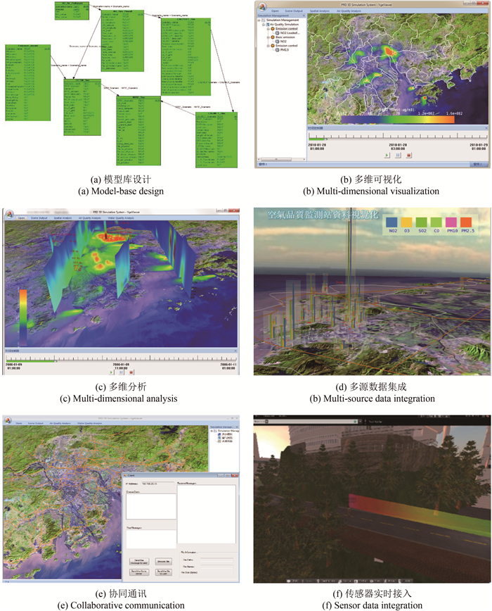
为此,本案例构建了多尺度气象和空气质量模型库,提供模型和模拟过程的集成与管理,通过“树”状结构管理多种模拟情景以加强决策型知识的生成;支持多维度地理过程可视化分析,以加强对气象和空气质量过程的认知,获得更为丰富的地理知识;而与其他地理数据(包括点、线、面、体类型)的集成分析,有助于新的地理知识发现;支持多用户协同工作机制,各领域专家和公众的参与加强了模拟分析的科学性以及对结果的认可度;此外,空气质量传感器的实时接入和阿凡达(Avatar)实时交互技术的实现,不只加强了VGEs表达的实时性,也加强了人们与VGEs交互的真实性,有助于对地理环境的认知(图 4)。
5 结语
作为地理数据和信息的更高层次,地理知识的表达和共享成为未来地理智慧发展的重要基础。依据地理知识的内容,本文将地理知识划分为事实型描述知识、规则及控制型知识和决策型知识。进而分析了地理语言不同阶段的特点,结合珠三角地区多尺度空气质量过程的VGEs平台,着重探讨了VGEs对地理知识表达与共享的支持。
地理语言同时也可看做是地理知识传播和分享的“底图”。在地理语言发展过程中,“底图”所承载内容越来越丰富,从2维的静态信息(如道路分布、地形起伏等)到多维动态地理过程的表达(空气质量过程、水文过程等),这有效加强了基于地理语言的知识交流和应用。此外,地理语言的发展对于“跨学科”系统性地解决地理学问题提供了基础,这正是人类研究地理学的根本出发点;同时,在解决过程中,普通大众及非地理学职业的人员不只是从地理学家那里获取地理信息,而是基于新一代地理语言可以实质性地参与到地理知识生产中,“体验他们的地理生活”(孙俊和潘玉君,2013)。
随着地理语言的发展,人类在地理知识表达和共享方面已经取得了长足的进步。然而高层次地理知识(如决策型知识)的表达与共享有赖于描述型和规则控制型知识的科学性、专业性、准确性和可靠性;同时,全民参与地理知识生产和共享的新时代已悄然而至,这又需要地理语言的表达和共享有较低的技术门槛和较高的易用性。针对上述需求,新一代的地理语言应结合计算机科学技术、知识发现方法、虚拟现实方法等的发展,平衡地顾及以上两个方面从而更好地表达与共享地理知识(Yuan,2009)。此外,地理知识的长期积累为地理知识库的构建、维护与应用提供基础同时又提出更高要求。虽然当前对地理知识的管理和时空推理方法、地理知识工程研究较多(Huang和Deng,2009;林珲和游兰,2015),如Janssen等(2009)提出基于本体的知识管理,但仍有待加强地理知识库的分解、表达、知识层次的推理方法等研究(马蔼乃,2001;Du等,2010)。此外,参考人工智能等领域对知识库和知识库管理系统的研究成果开展地理知识库的研究亦是值得借鉴的方向(吴长彬和闾国年,2008;李爱国,2011;苏正炼等,2015)。
参考文献(References)
-
Arciniegas G, Janssen R.2012.Spatial decision support for collaborative land use planning workshops. Landscape and Urban Planning, 107 (3): 332–342. DOI: 10.1016/j.landurbplan.2012.06.004.
-
Ardito C, Buono P, Costabile M F, Lanzilotti R, Piccinno A.2012.End users as co-designers of their own tools and products. Journal of Visual Languages & Computing, 23 (2): 78–90. DOI: 10.1016/j.jvlc.2011.11.005.
-
Blaut J M.1954.The language of maps. The Professional Geographer, 6 (11): 9–11. DOI: 10.1111/j.0033-0124.1954.061_9.x.
-
Celentano A, Pittarello F.2012.From real to metaphoric maps:cartography as a visual language for organizing and sharing knowledge. Journal of Visual Languages & Computing, 23 (2): 63–77. DOI: 10.1016/j.jvlc.2011.11.004.
-
Chen H, Li H W, Ma L L.2011.Application of ontology to geographic knowledge base construction. Geospatial Information, 9 (5): 78–80. ( 陈虎, 李宏伟, 马雷雷. 2011. 本体在地理知识库构建中的应用. 地理空间信息, 9 (5): 78–80. )
-
Chen M, Lin H, Hu M Y, He L, Zhang C X.2013.Real-geographic-scenario-based virtual social environments:integrating geography with social research. Environment and Planning B:Planning and Design, 40 (6): 1103–1121. DOI: 10.1068/b38160.
-
Chen M, Lin H, Kolditz O, Chen C.2015.Developing dynamic virtual geographic environments (VGEs) for geographic research. Environmental Earth Sciences, 74 (10): 6975–6980. DOI: 10.1007/s12665-015-4761-4.
-
Chen M, Lin H, Wen Y N, Hu M Y.2013.Construction of a virtual lunar environment platform. International Journal of Digital Earth, 6 (5): 469–482. DOI: 10.1080/17538947.2011.628415.
-
Chen M, Tao H, Lin H, Wen Y N.2011.A visualization method for geographic conceptual modelling. Annals of GIS, 17 (1): 15–29. DOI: 10.1080/19475683.2011.558024.
-
Chu J W, Fang Q P.2007.Comment on the theory and practice of knowledge sharing in china and abroad. Information Studies:Theory & Application, 30 (5): 705–709. ( 储节旺, 方千平. 2007. 国内外知识共享理论和实践述评. 情报理论与实践, 30 (5): 705–709. )
-
Dolk D R.1986.A generalized model management system for mathematical programming. ACM Transactions on Mathematical Software (TOMS), 12 (2): 92–126. DOI: 10.1145/6497.6501.
-
Du C, Xu J, Zhang J, Si W L, Liu B, Zhang D P. Spatial relation query based on geographic ontology//Proc.SPIE 7840, Sixth International Symposium on Digital Earth:Models, Algorithms, and Virtual Reality. Beijing, China: SPIE 2010 .
-
Gan L, Li L, Yin Z C.2006.Map knowledge representation based on XSLT. Science of Surveying and Mapping, 31 (3): 82–84. ( 甘莉, 李霖, 尹章才. 2006. 基于XSL的地图知识表达. 测绘科学, 31 (3): 82–84. )
-
Gong J H, Li Y B, Wang D J, Huang M X, Wang W X.2008.Characteristics and applications of knowledge maps in geographic knowledge visualization:a case study of spatial planning of dam systems in watersheds. Journal of Remote Sensing, 12 (2): 355–361. ( 龚建华, 李亚斌, 王道军, 黄明祥, 王伟星. 2008. 地理知识可视化中知识图特征与应用——以小流域淤地坝系规划为例. 遥感学报, 12 (2): 355–361. )
-
Goodchild M F. Geographic information systems//International Encyclopedia of the Social & Behavioral Sciences (Second Edition). Oxford: Elsevier 2015 : 58 -63.
-
Hu Z, Yan H W.2008.Analysis on linguistics mechanism for cartographic symbols and its application. Geography and Geo-Information Science, 24 (1): 17–20. ( 胡最, 闫浩文. 2008. 地图符号的语言学机制及其应用研究. 地理与地理信息科学, 24 (1): 17–20. )
-
Hu Z, Tang G A, Lu G N.2012.The concept and characteristics of GIS language. Acta Geographica Sinica, 67 (7): 867–877. ( 胡最, 汤国安, 闾国年. 2012. GIS作为新一代地理学语言的特征. 地理学报, 67 (7): 867–877. )
-
Huang X Q.2008.Study and implementation of model-base system based on object-oriented methods. Science & Technology Information (34): 85–91. ( 黄雪芹. 2008. 基于面向对象的模型库系统的研究及实现. 科技信息 (34): 85–91. )
-
Huang Y Q, Deng G Y. Research on representation of geographic Spatio-temporal information and Spatio-temporal reasoning rules based on Geo-ontology and SWRL//Proceedings of the 2009 International Conference on Environmental Science and Information Application Technology. 2009 .
-
Iyer B, Shankaranarayanan G, Lenard M L.2005.Model management decision environment:a Web service prototype for spreadsheet models. Decision Support Systems, 40 (2): 283–304. DOI: 10.1016/j.dss.2004.01.008.
-
Janssen S, Ewert F, Li H T, Athanasiadis I N, Wien J J F, Thérond O, Knapen M J R, Bezlepkina I, Alkan-Olsson J, Rizzoli A E, Belhouchette H, Svensson M , van Ittersum M K.2009.Defining assessment projects and scenarios for policy support:use of ontology in Integrated Assessment and Modelling. Environmental Modelling & Software, 24 (12): 1491–1500. DOI: 10.1016/j.envsoft.2009.04.009.
-
Laurini R.2014.A conceptual framework for geographic knowledge engineering. Journal of Visual Languages & Computing, 25 (1): 2–19. DOI: 10.1016/j.jvlc.2013.10.004.
-
Li A G.2011.Analysis and research of domain knowledge base. Electronic Design Engineering, 19 (16): 45–47. ( 李爱国. 2011. 领域知识库的研究与设计. 电子设计工程, 19 (16): 45–47. )
-
Li Y, Gong J H, Song Y Q, Liu Z G, Ma T, Liu H, Shen S, Li W H, Yu Y Y.2015.Design and key techniques of a collaborative virtual flood experiment that integrates cellular automata and dynamic observations. Environmental Earth Sciences, 74 (10): 7059–7067. DOI: 10.1007/s12665-015-4716-9.
-
Lin H, Zhu Q.2005.The linguistic characteristics of virtual geographic environments. Journal of Remote Sensing, 9 (2): 158–165. ( 林珲, 朱庆. 2005. 虚拟地理环境的地理学语言特征. 遥感学报, 9 (2): 158–165. )
-
Lin H, Batty M, Jørgensen S E, Fu B J, Konecny M, Voinov A, Torrens P, Lu G N, Zhu A X, Wilson J P, Gong J Y, Kolditz O, Bandrova T, Chen M.2015.Virtual environments begin to embrace process-based geographic analysis. Transactions in Gis, 19 (4): 493–498. DOI: 10.1111/tgis.12167.
-
Lin H, Chen M, Lu G N.2013b.Virtual geographic environment:a workspace for computer-aided geographic experiments. Annals of the Association of American Geographers, 103 (3): 465–482. DOI: 10.1080/00045608.2012.689234.
-
Lin H, Chen M, Lu G N, Zhu Q, Gong J H, You X, Wen Y N, Xu B L, Hu M Y.2013a.Virtual geographic environments (VGEs):a new generation of geographic analysis tool. Earth-Science Reviews, 126 : 74–84. DOI: 10.1016/j.earscirev.2013.08.001.
-
Lin H, Gong J H, Shi J J.2003.From maps to GIS and VGE:a discussion on the evolution of the geographic language. Geography and Geo-Information Science, 19 (4): 18–23. ( 林珲, 龚建华, 施晶晶. 2003. 从地图到地理信息系统与虚拟地理环境——试论地理学语言的演变. 地理与地理信息科学, 19 (4): 18–23. )
-
Lin H, You L.2015.A tentative study on knowledge engineering for Virtual Geographic Environments. Journal of Geo-information Science, 17 (12): 1423–1430. DOI: 10.3724/SP.J.1047.2015.01423. ( 林珲, 游兰. 2015. 虚拟地理环境知识工程初探. 地球信息科学学报, 17 (12): 1423–1430. DOI: 10.3724/SP.J.1047.2015.01423. )
-
Liu R, Yang W J.2009.Geographical CVE:theory and framework. Bulletin of Surveying and Mapping (10): 28–31. ( 刘锐, 杨卫军. 2009. 协同虚拟地理环境理论与框架. 测绘通报 (10): 28–31. )
-
Lü G N.2011.Geographic analysis-oriented Virtual Geographic Environment:framework, structure and functions. Science China Earth Sciences, 54 (5): 733–743. DOI: 10.1007/s11430-011-4193-2.
-
Ma A N.2001.Formalization of geographical knowledge. Science of Surveying and Mapping, 26 (4): 8–12. ( 马蔼乃. 2001. 地理知识的形式化. 测绘科学, 26 (4): 8–12. )
-
Mekni M, Moulin B. Motion planning of autonomous agents situated in informed virtual geographic environments//Proceedings of the 2010 Second International Conference on Advanced Geographic Information Systems, Applications, and Services. 2010 .
-
Morrison A, Mulloni A, Lemmelä S, Oulasvirta A, Jacucci G, Peltonen P, Schmalstieg D, Regenbrecht H.2011.Collaborative use of mobile augmented reality with paper maps. Computers & Graphics, 35 (4): 789–799. DOI: 10.1016/j.cag.2011.04.009.
-
Nissen H A, Evald M R, Clarke A H.2014.Knowledge sharing in heterogeneous teams through collaboration and cooperation:Exemplified through Public-Private-Innovation partnerships. Industrial Marketing Management, 43 (3): 473–482. DOI: 10.1016/j.indmarman.2013.12.015.
-
Pinjani P, Palvia P.2013.Trust and knowledge sharing in diverse global virtual teams. Information & Management, 50 (4): 144–153. DOI: 10.1016/j.im.2012.10.002.
-
Rollins N D, Barton C M, Bergin S, Janssen M A, Lee A.2014.A Computational Model Library for publishing model documentation and code. Environmental Modelling & Software, 61 : 59–64. DOI: 10.1016/j.envsoft.2014.06.022.
-
Rowley J.2007.The wisdom hierarchy:representations of the DIKW hierarchy. Journal of Information Science, 33 (2): 163–180. DOI: 10.1177/0165551506070706.
-
Rowley J, Hartley R. Organizing Knowledge:An Introduction to Managing Access to Information. Guildford: Ashgate Publishing, Ltd 2006 .
-
Schmidt E K.2008.Research management and policy:incentives and obstacles to a better public-private interaction. International Journal of Public Sector Management, 21 (6): 623–636. DOI: 10.1108/09513550810896505.
-
Seagren C W.2015.A replication and analysis of Tiebout competition using an agent-based computational model. Social Science Computer Review, 33 (2): 198–216. DOI: 10.1177/0894439314534810.
-
Su Z L, Yan J, Chen H S, Zeng Y H.2015.Construction of ontology-based equipment fault knowledge base. Systems Engineering and Electronics, 37 (9): 2067–2072. ( 苏正炼, 严骏, 陈海松, 曾拥华. 2015. 基于本体的装备故障知识库构建. 系统工程与电子技术, 37 (9): 2067–2072. )
-
Sun J, Pan Y J.2013.Comments on "Crowdsourcing Geographic Knowledge:Volunteered Geographic Information (VGI) in Theory and Practice". Acta Geographica Sinica, 68 (11): 1590–1591. ( 孙俊, 潘玉君. 2013. 《众包地理知识:自愿地理信息的理论与实践》评介. 地理学报, 68 (11): 1590–1591. )
-
Thiele J C, Grimm V.2015.Replicating and breaking models:good for you and good for ecology. Oikos, 124 (6): 691–696. DOI: 10.1111/oik.02170.
-
Tsai Y-C.2001.Comparative analysis of model management and relational database management. Omega, 29 (2): 157–170. DOI: 10.1016/S0305-0483(00)00036-0.
-
Van Der Wal Z, De Graaf G, Lasthuizen K.2008.What's valued most? Similarities and differences between the organizational values of the public and private sector. Public Administration, 86 (2): 465–482. DOI: 10.1111/j.1467-9299.2008.00719.x.
-
Wang F Q. Research on the Theory and Methods in Constructing Geo Spatial Knowledge Map. Zhengzhou: The PLA Information Engineering University 2013 : 1 -67. ( 王富强. 2013. 空间知识地图构建理论和方法研究. 郑州: 解放军信息工程大学 : 1 -67. )
-
Wang J Y, Chen Y F. Theoretical Cartography. Beijing: Chinese People's Liberation Army Publishing House 2000 : 12 -46. ( 王家耀, 陈毓芬. 2000. 理论地图学. 北京: 解放军出版社 : 12 -46. )
-
Wu C B, Lu G N.2008.Establishment and application of land and resource knowledge base. Geography and Geo-Information Science, 24 (4): 70–74. ( 吴长彬, 闾国年. 2008. 国土资源知识库的建设与应用. 地理与地理信息科学, 24 (4): 70–74. )
-
Xu B L, Lin H, Chiu L S, Hu Y, Zhu J, Hu M Y, Cui W N.2011.Collaborative virtual geographic environments:a case study of air pollution simulation. Information Sciences, 181 (11): 2231–2246. DOI: 10.1016/j.ins.2011.01.017.
-
Yang D, Miao R, Wu H W, Zhou Y T.2009.Product configuration knowledge modeling using ontology web language. Expert Systems with Applications, 36 (3): 4399–4411. DOI: 10.1016/j.eswa.2008.05.026.
-
Yin L Z, Zhu J, Zhang X, Li Y, Wang J H, Zhang H, Yang X F.2015.Visual analysis and simulation of dam-break flood spatiotemporal process in a network environment. Environmental Earth Sciences, 74 (10): 7133–7146. DOI: 10.1007/s12665-015-4418-3.
-
Yuan M. Toward knowledge discovery about geographic dynamics in spatiotemporal databases//Miller H J and Han J, eds.Geographic data mining and knowledge discovery. London: CRC Press 2009 : 347 -365.
-
Yue S S, Wen Y N, Chen M, Lu G N, Hu D, Zhang F.2015.A data description model for reusing, sharing and integrating geo-analysis models. Environmental Earth Sciences, 74 (10): 7081–7099. DOI: 10.1007/s12665-015-4270-5.
-
Zhang C X, Chen M, Li R R, Ding Y L, Lin H.2015.A virtual geographic environment system for multiscale air quality analysis and decision making:a case study of SO2 concentration simulation. Applied Geography, 63 : 326–336. DOI: 10.1016/j.apgeog.2015.07.011.
-
Zhang C X, Chen M, Li R R, Fang C Y, Lin H.2016.What's going on about geo-process modeling in virtual geographic environments (VGEs). Ecological Modelling, 319 : 147–154. DOI: 10.1016/j.ecolmodel.2015.04.023.
-
Zhang C X, Lin H, Chen M.2014.Discussion about scale adaptability in virtual geographic environments. Acta Geographica Sinica, 69 (1): 100–109. ( 张春晓, 林珲, 陈旻. 2014. 虚拟地理环境中尺度适宜性问题的探讨. 地理学报, 69 (1): 100–109. )
-
Zhang Y N, Wang Y, Min Y F, Zhao X R, Kang J F.2013.Review and prospects of e-Geoscience. E-Science Technology & Application, 4 (6): 15–28. ( 张耀南, 汪洋, 敏玉芳, 赵雪茹, 康健芳. 2013. 地学e-Science发展的回顾与展望. 科研信息化技术与应用, 4 (6): 15–28. )
-
Zhao G H, Zhang Y N, He Z F, Cui D D.2013.Geoscience simulation environment based on high-performance computing platform. E-Science Technology&Application, 4 (6): 71–77. ( 赵国辉, 张耀南, 何振芳, 崔丹丹. 2013. 基于高性能计算平台的地学集成模拟分析环境研究. 科研信息化技术与应用, 4 (6): 71–77. )
-
Zheng X Q.2012.On the geographic system simulation basic model. Chinese Journal of Nature, 34 (3): 143–149. ( 郑新奇. 2012. 论地理系统模拟基本模型. 自然杂志, 34 (3): 143–149. )


