|
|

|
收稿日期: 2015-02-09; 修订日期: 2015-05-04;
优先数字出版日期: 2015-05-11
基金项目: 中国科学院重点部署项目(编号: KZZD-EW-TZ-18);国家自然科学基金(编号: 41371360)
第一作者简介: 周倜(1991- ), 女, 硕士研究生 ,主要从事地表能量平衡遥感估算方面的研究。E-mail: zhouti9001@gmail.com
通信作者简介: 辛晓洲(- ) ,男 ,副研究员 ,从事地表辐射与能量平衡遥感估算理论与方法研究。E-mail: xin_xzh@163.com
中图分类号: P426.2/TP79
文献标识码: A
文章编号: 1007-4619(2016)02-0257-21
|
摘要
本文评述了目前常用的遥感估算地表蒸散方法,包括地表能量平衡模型、Penman-Monteith类模型、温度—植被指数特征空间方法、Priestley-Taylor类模型和其他方法。然而使用这些方法估算地表蒸散时会面临严重的尺度效应,而产生尺度效应的根本原因之一是地表异质性,在分析了非均匀下垫面对水热通量遥感反演造成的影响后,介绍了面积加权、校正因子补偿与温度降尺度3种尺度误差纠正方法;并从地面观测实验的角度简述了非均匀下垫面水热通量真实性检验的研究;最后探讨了将来建立更具时空代表性的非均匀下垫面地表蒸散遥感估算模型可能会面临的一些挑战。
关键词
遥感, 蒸散, 模型, 尺度效应, 非均匀下垫面, 地面实验
Abstract
This review surveys the most currently used evapotranspiration estimation methods based on remote sensing. The methods are divided into different categories, including surface energy balance models, Penman–Monteith models, land surface temperature–vegetation index space methods, Priestley–Taylor models, empirical statistical methods, complementary methods, and land process assimilation models.
These methods are mainly focused on two problems. The first problem is how to deal with aerodynamic surface temperature used in gradient diffusion equation. One-source models have two major solutions. One is to use remotely sensed radiative temperature as a direct substitution for aerodynamic surface temperature or use semi-empirical relations to obtain the surface–atmospheric differential temperature. In two-source models, the heat fluxes are decomposed by component temperature. The second problem is how to calculate surface resistance that influences heat flux exchange from the soil surface and canopy layers. This process is complicated to calculate at the local scale. Basing from the two problems, scientists combined the features and superiority of remote sensing, such as the relationship between various vegetation indices and surface parameters with the fundamental theory of these methods, and developed these methods from saturated surface toward unsaturated surface to calculate evapotranspiration.
However, severe scale effects emerge when these methods are used in heterogeneous surfaces. Surface heterogeneity influences the driving force of evapotranspiration estimation. Thus, three methods to correct scale error over heterogeneous surfaces are shown in detail: area weighting method, correction factor method, and land surface temperature downscaling (or thermal spatial sharpening) method. The core concepts of these methods are to couple high and low spatial resolution satellite data and statistically quantify the inhomogeneity in mixed pixels to correct the scale error in evapotranspiration estimation. In meteorological science, land process models using mosaic (or area-weighted method) and statistical dynamic methods are developed for heterogeneous surfaces. In the statistical dynamic method, one single or two mutually independent surface parameters or atmospheric forces are regarded as random variables. Consequently, their spatial distributions are expressed as probability density function to be melted into evapotranspiration retrieval models. These ideas are worthy to be adopted in remotely sensed evapotranspiration estimation.
As another important part of evapotranspiration estimation, the progress of turbulent heat flux validation research over heterogeneous surfaces is introduced at length from the angle of observation experiments. The measured heat fluxes possibly originate from source areas instead of in situ pixels. Thus, the traditional validation method that compares the retrieved pixel value with the observation value to evaluate result accuracy may cause uncertainty. Some schemes are developed using footprint models to determine the scope and weight of source area pixels and decrease the uncertainty in validation. Moreover, we provide a brief introduction of the basic principles of the footprint models that are mostly used in remote sensing in the present case. These models include Eulerian analytic flux footprint models and Lagrangian stochastic trajectory approach.
Finally, we discuss the challenges that researchers may encounter in the future to develop representative models of remotely sensed evapotranspiration retrieval over heterogeneous surfaces.
Key words
remote sensing, evapotranspiration, model, scale effect, heterogeneous surface, surface observation experiment
1 引 言
地表蒸散ET(Evapotranspiration)是地球水圈、大气圈和生物圈水分交换的重要过程(Priestley和Taylor,1972)。精确估算蒸散量对水资源合理利用和管理决策有重要参考意义(Brutsaert,1982)。此外,蒸散发是陆面过程中地气相互作用的重要过程之一,也是短期数值天气预报模型和全球气候模式必不可少的参数(Jung等,2010; Shukla和Mintz,1982)。遥感估算蒸散发是遥感科学的重要研究方向,用卫星遥感准确计算地表蒸散在农业、气象和生态等领域有重要研究意义和应用价值(Abtew和Melesse,2013)。
经过数十年的发展,遥感估算地表蒸散的技术手段在模型、方法和卫星数据应用等方面获得很大进展,但是在非均匀下垫面的区域仍存在很大问题。非均匀是相对均匀的情况而言,从遥感计算通量的角度看,一般将浓密的单一类型植被、裸土和水体等表面信息特征比较均匀的像元定义为“纯像元”或“均质块”,而非均匀下垫面指像元内存在非连续变化信息特征,可细分为两种情况:一是亚像元间地物覆盖密度非线性变化,如不同植被类型覆盖;二是像元中存在截然不同的地表覆盖类型,如水体和建筑等。
边界层的水热通量交换是复杂非线性的湍流输送过程,而地球表面几何、物理属性的高度非均匀性,使其研究难度大大增强。遥感在像元上对辐射传输与陆面过程定量描述时会面临严重的尺度效应,而卫星数据的多时空分辨率特性,使得这一问题尤为突出。目前都是通过一些统计方法纠正空间尺度误差,建立非均匀下垫面的遥感估算地表蒸散模型,使估算结果更加准确并具有代表性,是今后发展的必然方向,也是推动定量遥感应用发展的重要环节。本文系统回顾了非均匀下垫面遥感估算地表蒸散的研究进展,希望对后续相关研究有一定参考意义。
2 遥感估算地表蒸散的方法
目前遥感估算区域水热通量的方法主要有地表能量平衡模型、Penman-Monteith类模型、温度—植被指数特征空间方法、Priestley-Taylor类模型和其他方法(包括经验统计方法、互补相关模型和陆面过程与数据同化方法)。
2.1 地表能量平衡模型
遥感估算蒸散模型的理论基础是能量平衡方程,不考虑平流引起的能量输送、植被光合与呼吸作用,以及地表能量存储过程时,在垂直方向上,认为地表单位面积的净辐射Rn可分解为由蒸散消耗的潜热通量LE、由于存在温度梯度而进行热交换的显热通量H与土壤热通量G:
${R_n} = LE + H + G $ (1)
式中,各项单位均为W · m-2。
根据边界层湍流梯度输送理论,两位置间的物质与能量交换可看作是两处的势差引起,并由当地的大气环境、地表和植被属性决定的阻抗所控制(Kalma等,2008),可得计算显热和潜热通量的公式:
$ H = \rho\cdot{c_\rm p}\frac{{{T_\rm {aero}} - {T_\rm a}}}{{{r_\rm a}}}$ (2)
$LE = \frac{{\rho\cdot{c_\rm p}}}{\gamma }\frac{{{e_\rm s} - {e_\rm a}}}{{{r_\rm a} + {r_\rm s}}} $ (3)
式中,ρ表示空气密度(kg · m-3),cp为空气定压比热(J · kg-1· K-1),Taero表示土壤和植被热源(汇)高度处的空气动力学温度,Ta为参考高度的空气温度(K),ra是空气动力学阻抗(s · m-1),rs是表面水汽扩散阻抗(s · m-1),γ 是干湿球常数(Pa · K-1),es和ea分别是蒸发表面水汽压和大气水汽压(Pa)。
地表能量平衡模型是目前应用最为广泛的模型,采用余项法计算蒸散量,根据其对土壤—植被-大气连续体SPAC(Soil-Plant-Atmosphere Continuum)通量源(汇)的处理,可分为单源模型,双源模型。
2.1.1 单源模型
单源模型忽略土壤植被内部能量及水分的相互作用,把SPAC看做一片均匀的大叶,这片叶子的温度、含水量、辐射等量就代表整个地表相应的物理量,并与外界空气交换动量、热量和水汽(Monteith,1965;辛晓洲等,2003)。根据边界层相似性理论,在粗糙表面与湍流热通量传输直接相关的是空气动力学温度Taero,它是气温廓线向下延伸到冠层中通量源(汇)高度的空气温度。然而Taero 很难由遥感方法获取,所以一般使用遥感反演的表面辐射温度Tr替代Taero,但二者的物理意义有很大区别。研究表明,Taero和Tr 在浓密的植被中相差1-2°C,而在稀疏植被覆盖下的差距更大(Choudhury等,1986;Kustas等,1989)。为此出现了一些订正方法,如调整阻抗(Kustas等,1989;Su,2002;陈镜明,1988),直接调整辐射温度和空气动力学温度的温差(Chehbouni等,1996;Watts等,2000)等,其中广泛应用的经典模型有SEBS(Su,2002),SEBAL(Bastiaanssen等,1998a,1998b),之后的许多模型都是在它们基础上发展的,如在SEBAL中引入天气数据和参考作物蒸散,且不再局限于平坦地区的METRIC模型(Allen等,2007);还有结合地表温度—植被覆盖度特征空间以降低SEBAL中冷热点选取主观性的M-SEBAL模型(Long和Singh,2012a)等。
单源模型在植被覆盖浓密、均一时可以较好地模拟地表的湍流热通量;但很大程度上依赖于粗糙度长度以及表面辐射温度与空气动力学温度差的精度;同时在半湿润、植被不太茂密或半干旱、干旱的植被稀疏区,单一均匀下垫面的假设显然是不满足的。
2.1.2 双源模型
双源模型把地表分解为土壤和植被两个组分,它们分别是水热交换的两个源。根据植被和土壤的相互作用机制及阻抗联结方式不同,又分为串联模型(Shuttleworth和Wallace,1985)和并联模型(Kustas和Norman,1999;Norman等,1995)。使用双源模型需要将卫星遥感反演的地表温度组分分解为土壤温度和植被冠层温度,而遥感中很多情况是只有一个观测角度的表面辐射温度Tr(θ),导致方程个数小于未知数个数,所以模型应用之初,常结合类似Penman-Monteith的公式计算地表蒸散(Shuttleworth和Wallace,1985)。后来学者们提出了一些简化方法来求解方程(Lhomme等,1994;辛晓洲,2003),也发展了通过多角度观测遥感数据反演得到地表组分温度,从而计算地表和植被的能量平衡分量的方法(Kustas和Norman,1997),但仍然应用不广泛。此外,学者们另辟蹊径,假设植被未受水分胁迫,以潜在蒸腾量向大气蒸腾水分,在此基础上借助Priestley-Taylor公式近似计算组分温度(Xin和Liu,2010)或潜热通量,如著名的N95模型(Norman等,1995),在N95的基础上耦合了一个边界层大气模型作为约束条件的ALEXI(Atmosphere L and Exchange Inverse)模型(Anderson等,1997;Mecikalski等,1999)。串联(Shuttleworth-Wallace)模型对关键参数阻抗十分敏感,Zhu等人(2013,2014)利用地面实验数据等先验知识,结合贝叶斯反演理论和马尔可夫链模拟阻抗,大大降低了参数估计的不确定性。
双源模型增加了土壤对通量的贡献,相对于单源模型更真实地刻画了SPAC之间的水热交换机制,在理论上是一种进步,在稀疏植被覆盖区域或干旱、半干旱地区都取得了较为理想的模拟结果(刘雅妮等,2005)。遥感反演组分温度的成功使得真正意义上的双源模型应用成为可能,但多角度热红外技术在卫星数据层面推广还有一定难度,且目前组分温度反演的精度还有待提高;另外,净辐射受植被结构、观测角度等影响,会给通量的反演带来不确定性。
2.2 Penman-Monteith类模型
Penman(1948)结合空气动力学与能量平衡理论估算湿润下垫面地表蒸散,Monteith(1965)在此基础上,引入冠层表面阻抗 rs,考虑了地表植被生长和土壤供水的影响,为非饱和下垫面蒸散研究开辟了新途径,得到著名的Penman-Monteith方程:
$ LE = \frac{{\Delta \left({{R_\rm n} - G} \right)+ \rho {c_{_\rm P}}\left({{e^*}\left({{T_{\rm{a}}}} \right)- {e_\rm a}} \right)/{r_\rm a}}}{{\Delta + \gamma \left({1 + {r_\rm s}/{r_\rm a}} \right)}}$ (4)
式中,e*(Ta)为空气温度为 Ta 时的饱和水汽压,单位为 Pa,Δ = de */dT,单位为 Pa · K-1。遥感可以提供各种阻抗所涉及的部分下垫面特征参数,如叶面积指数LAI(leaf area index);光合有效辐射吸收比FPAR(fraction of absorbed photosynthetically active radiation)以及植被覆盖度fc等,提高了Penman-Monteith类模型的可操作性,并逐渐分离土壤蒸发与植被蒸腾,向双源模型的方向发展。Cleugh等人(2007)提出直接使用LAI来估算冠层阻抗,然而,这种方法是基于对冠层阻抗近似等于地表阻抗以及地表蒸发相对植被蒸腾很小的假设。Mu等人(2007)对此进行了改进,通过增加饱和水汽压差VPD(vapor pressure deficit)因子以及最低空气温度因子,分别用来约束当VPD过高抑制光合作用时以及处于最低空气温度下的潜在气孔导度,改进了气孔导度的算法,并把土壤蒸发与植被蒸腾分开,结合气象数据分别使用Penman-Monteith公式计算,以下简称其为“Mu-2007”。在这两项研究的基础上,学者们结合不同的表面阻抗计算方法,发展了对土壤蒸发或植被蒸腾的修改算法。Mu等人(2011)提出把蒸散量分成白天和夜间分别计算,并加入了之前一直被忽略不计的土壤热通量,分别根据不同下垫面的生理过程计算各自的空气动力学阻抗和冠层阻抗。此外,将冠层分为干湿冠层,土壤表面分为潮湿与饱和两种状态进行计算,并成为MOIDS蒸散产品的官方算法业务化运行;Sun等人(2013)在地表温度—植被覆盖度的特征空间内插值相对土壤湿度指数SMI(soil moisture index)计算Mu-2007模型中的土壤蒸发;Yuan等人(2010)引入最佳温度,并以指数非线性的形式代替了Mu-2007中温度线性内插计算气孔导度的方法,进而计算植被蒸腾;同时,Leuning等人(2008)在Cleugh和Mu在2007年提出的算法基础上,使用植被覆盖度和能量衰减系数来计算地表和冠层导度,并引入平衡蒸发比计算土壤蒸发;Song等人(2012)沿用Leuning等人(2008)研究中平衡蒸发比的概念,使用N-P方案计算冠层阻抗,发展了适用于干旱区的Penman-Monteith模型。Zhao等人(2010)比较了Penman-Monteith模型使用此N-P(Noilhan和Planton,1989)和J-D(Jacobs和de Bruin,1997)两种冠层阻抗参数化方案估算的蒸散结果,并与EC观测比较,表明N-P方案的Penman-Monteith模型结果与观测更吻合。
Penman-Monteith模型在估算致密冠层的蒸散发中有较好的精度(Thom,1972)和稳健性,并且双源Penman-Monteith模型效果更优(Chen等,2013a)。其优点在于计算中不需要知道地表或组分温度,然而由于植被蒸腾受生理特征、根系供水等的影响,使气孔阻抗的性质非常复杂,且计算冠层阻抗时常把叶片看作均匀的,因此在粗糙和复杂下垫面下难以准确计算表面阻抗(Petropoulos,2013);同时在应用到区域尺度时,需要精确模拟参考高度风温湿压等气象驱动数据。
2.3 温度—植被指数(LST-VI)特征空间方法
当图像的像元数量足够多时,植被指数和地表温度组成的2维散点分布图会形成类似三角形或梯形,称为LST-VI特征空间。特征空间主要包括以下4种类型(田苗等,2010):地表温度和植被指数/覆盖度构成的特征空间;地表温度和反照率构成的特征空间;地气温差和植被指数/覆盖度构成的特征空间;昼夜温差和植被指数/覆盖度构成的特征空间。特征空间以较简单的线性关系描述了地表温度、植被状况及土壤湿度三者间的关系,它的出现是由于植被指数增加使得地表辐射温度的变化范围减少(Carlson,2007)。研究表明,由于LST-VI特征空间与土壤湿度以及植被蒸腾的冠层阻抗相关性很强,可用于蒸散量及其参数的估算(Carlson等,1995b;Nemani和Running,1989),其理论基础是:白天,地表由于吸收太阳辐射而加热增温,潮湿表面的温度变化总是相对较小,因为热惯性的存在使得潮湿表面需要消耗更多的能量用于蒸散(Wang和Dickinson,2012)。
通过确定LST-VI特征空间的干湿边,分别对应最小和最大的蒸散,在特征空间内对蒸发率、作物缺水指数(Moran等,1996)或Priestley-Taylor系数(Wang等,2006)进行线性插值,再结合Penman-Monteith或Priestley-Taylor方程求解潜热通量(Carlson,2007;Jiang和Islam,1999,2001)。此外,Yang和Shang(2013)使用特征空间对土壤温度进行插值分解地表温度,再用能量平衡双源并联模型计算潜热通量。张仁华等人(2004,2009)在Tr-fc梯形特征空间内,以混合像元组分排序对比法PCACA为基础,通过对理论方程求解定位绝对干湿点,提高其可靠性;最后采用分层能量切割法,避免了多种阻抗计算的繁琐过程,提高了双源模型的可操作性,为地表通量的区域尺度扩展开辟了一条新的途径。Long和Singh(2012b)将这种由理论方程求解绝对干湿边的方法简化并推广到更一般的形式,并用蒸发率计算蒸散。
LST-VI特征空间模型不需要过多的大气或地面辅助数据且能在大的尺度上获得良好精度。虽然目前已有通过区间分割,回归迭代自动获得干边的方法(Tang等,2010),但是仍然具有一定主观性。同时研究区域必须足够大才能形成特征空间,然而研究区域太大,必然会导致区域内的辐射输入不一致,可能导致能量不平衡;同时要求涵盖的地表信息和土壤湿度变化完全覆盖,却没有考虑特征空间对植被覆盖类型的依赖性,如不同植被覆盖阻抗的差异性。
2.4 Priestley-Taylor类模型
Priestley和Taylor(1972)在平衡蒸发的基础上,忽略Penman-Monteith公式的空气动力学项,引入经验系数,建立了计算饱和下垫面蒸散发的Priestley-Taylor模型:
$ LE = \alpha \frac{\Delta }{{\gamma + \Delta }}\left({{R_\rm n} - G} \right)$ (5)
式中,α为Priestley-Taylor系数,并认为饱和下垫面条件下取值1.26最合理。后来有学者分析各自的观测资料得到不同的α值(Davies和Allen,1973;Mukammal和Neumann,1977),并发现α存在日变化和季节变化。这些都表明α不是一个常数,它实际上反映了平流的变化情况,在不同平流条件下α可以有不同的值,因此若将α当作变量,则Priestley-Taylor模型也可用于估算平流条件下的蒸发力(刘绍民,1998)。
最初,Priestley-Taylor模型是针对饱和下垫面进行计算的,但由于其参数简单,物理意义明确,许多学者将其引入非饱和下垫面或结合其他模型估算蒸散量。Davies和Allen(1973)将Priestley-Taylor系数视为随表面湿度变化的变量并用负指数关系进行非线性拟合计算;Barton(1979)在Priestley-Taylor方程中引入蒸发表面干燥程度的概念,为遥感应用提供了一种切实可行的方法;Fisher等人(2008)另辟蹊径,在α保持不变(取值1.26)的情况下,利用生理胁迫因子(LAI、植被覆盖度和植被温度胁迫因子等)以及基于互补相关理论的土壤蒸发分割机制,将Priestley-Taylor方程计算的饱和蒸散转换为实际蒸散,开展了全球蒸散估算研究;Yao等人(2013)在此基础上进行了改进,利用NDVI和表观热惯量参数化了Priestly-Taylor模型,提高了其在遥感应用中的可操作性和模拟精度。随着地表温度—植被指数特征空间方法的发展,在Priestley-Taylor方程中融合特征空间干湿边的物理意义,拓宽了Priestley-Taylor模型估算蒸散的途径。Jiang和Islam(1999,2001)提出了代表Priestley-Taylor系数和表面湿度综合作用的参数Φ以代替Priestley-Taylor系数α,相当于扩展了Priestley-Taylor系数的意义,并使用LST-NDVI三角形特征空间插值计算Φ,进而估算蒸散发;此后很多学者也进行了相关的研究(Wang等,2006; Tang等,2010; Jin等,2011)。
Priestley-Taylor模型忽略了Penman-Monteith方程中的空气动力学项,而简单地使用Priestley-Taylor系数来扩展计算蒸散,但其受地表反照率、大气状况以及地表类型的影响较大,系数扩展的准确性难以确定且无法解释其物理含义,对估算结果的不确定性造成很大影响。
2.5 其他方法
2.5.1 经验统计方法
经验统计方法最早由Jackson等人(1977)提出,其基本思想是将地面气象数据与遥感数据结合起来,通过分析影响蒸散的敏感性参数,直接拟合回归敏感性参数与水热通量或蒸发比之间的统计关系计算实际蒸散量(Carlson等,1995a; Seguin和Itier,1983)。如研究表明,地表蒸散量与植被指数之间存在较强相关性(Loukas等,2005;Glenn等,2007),Wang等人(2007)、Wang和Liang(2008)考虑地表昼夜温度变化和土壤湿度的影响,使用日总净辐射、气温、植被指数(EVI或NDVI)回归得到估算蒸散的经验统计方程,并运用到全球尺度的蒸散发量估算,反演结果能很好地表现出蒸散发的季节变化趋势。
经验统计方法简单,所需参数较少,可操作性强,但是由于其过于简化,对蒸散过程内在机理考虑极少,缺乏统一的标准,使得不同区域之间经验系数差异性大,导致其可移植性较差,限制了其区域外推的应用。
2.5.2 互补相关模型
Bouchet(1963)提出了陆面实际蒸散与潜在蒸散之间的互补相关原理。对同质地表,在一定的时间段内,接受到的总太阳辐射基本相等,并且主要用于蒸发,增加气温和土温;当水分供应充足时,该区域的实际蒸散EA与潜在蒸散EP相等,且等于充分湿润环境下的蒸散EW。当存在水分胁迫时,实际蒸散会减少,则太阳辐射存在剩余,导致潜在蒸散的增加,此部分增加的潜在蒸散与剩余能量相等(徐兴奎等,1999):
${E_\rm P} + {E_\rm A} = 2{E_\rm W} $ (6)
互补相关模型又可分为3类(刘绍民等,2004):平流干旱模型、CARE(Complementary Relationship Areal Evapotranspiration)模型和Granger模型。其简化了蒸散机制,只需常规的气象观测数据即可相对简单地估算流域尺度的蒸散发,但是当大气湿度发生变化时,接收的太阳辐射量也会发生变化,且忽略了平流和大尺度天气效应的影响,在干旱及湿润两种极端条件下,估算效果不太理想(Liu等,2006)。
2.5.3 陆面过程与数据同化方法
数据同化方法估算蒸散的核心思想是:在陆面过程模型的动力框架内,将陆面过程模型拟合结果与地面(气象数据、常规观测数据等)、遥感数据相融合,以不断依靠观测自动调整陆面模型轨迹和状态变量,从而提高地表热通量(包括显热和潜热)的模拟与预报精度(李新等,2007;姚云军等,2012)。Margulis等人(2005)将数据同化计算的潜热通量结果、LST-VI三角形特征空间的计算结果与地面观测数据对比,发现数据同化的计算结果略优于特征空间。徐同仁等人(2009)基于集合卡尔曼滤波和通用陆面模型发展了一个地表温度的同化系统,并引入MODIS温度和LAI产品,主要用于改进水热通量的估算精度。Bateni和Liang(2012)提出了将土壤蒸发与植被蒸腾分割的双源变分数据同化系统;Xu等人(2014)比较了不同覆被下单、双源变分数据同化的结果,表明二者在干旱、稀疏植被站点的表现优于湿润、浓密植被站点,且双源方案结果普遍优于单源方案,此外针对模型结构和输入参数的不确定性,Xu等人(2015)提出弱限制的变分同化方案。
使用陆面过程与数据同化方法估算地表蒸散时,也可同时对许多中间变量进行估值。由于数据同化的动力模型对离散采样时间进行插值,其反演的潜热通量是时空连续分布的,且能对来自不同分辨率、覆盖范围和不确定性数据源的空间分布信息进行融合。由于其使用数值模型,比一般的遥感估算蒸散模型的计算量大得多,尤其是输入高分辨率图像时(Li等,2009b);同时需要输入很多难以在区域尺度获得的与土壤和植被属性有关参数。
3 非均匀下垫面蒸散研究进展
3.1 遥感估算地表蒸散尺度效应分析
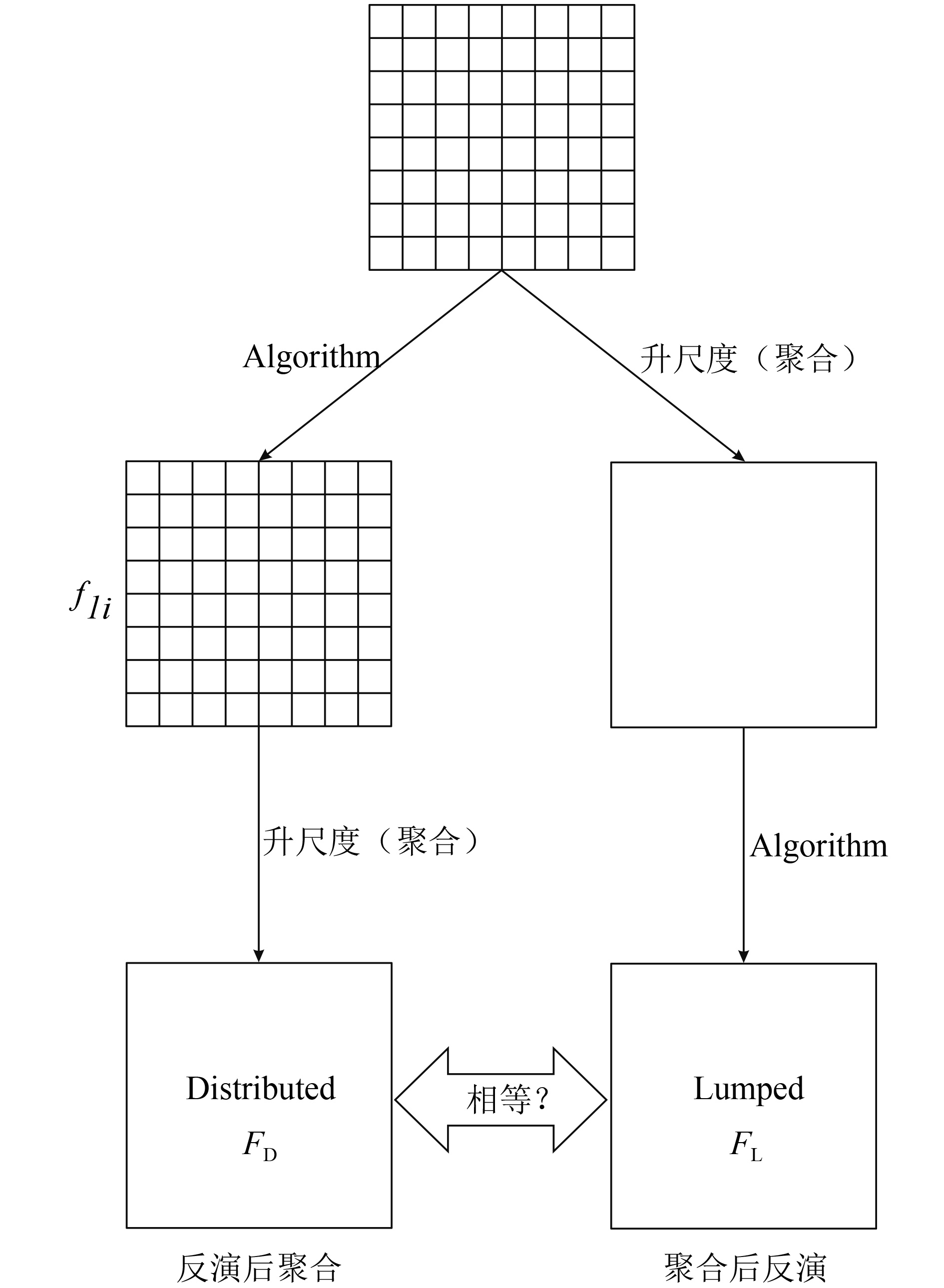
空间尺度问题影响着遥感估算地表蒸散的结果,图 1是尺度效应研究中升尺度的两种方法,其中FD是对高空间分辨率的数据或参数先使用模型反演水热通量,再将得到的水热通量聚合到低空间分辨率(此处聚合指取平均值),最终得到“先反演后聚合”的结果;FL是对高空间分辨率数据或参数先聚合到低空间分辨率,再使用模型估算地表蒸散,即“先聚合后反演”的结果。研究发现二者存在很大的差异,又称其为尺度误差,此即遥感估算地表蒸散的尺度效应(McCabe和Wood,2006; Gebremichael等,2010; Teluguntla等,2011)。

Moran等人(1997)估算半干旱牧场的显热通量时,发现当像元内部混有小块其他地物时,“先反演后聚合”与“先聚合后反演”计算得到的显热通量差异较大,像元尺度上甚至可达到50%。Hong等人(2009)将30 m分辨率的L and sat ETM+影像升尺度至MODIS像元的分辨率(250 m)并用SEBAL模型计算显热通量时,发现像元尺度上的蒸散峰值增加了10%—25%。Ershadi等人(2013)对L and sat 5遥感数据升尺度后发现整幅影像的蒸散值降低了15%,像元尺度上差异达到50%。
Hu和Islam(1997)从通用遥感反演函数入手,对“聚合后反演”的结果和“反演后聚合”的结果使用泰勒公式展开,计算二者的差值,对该项进行分析后发现尺度效应产生的原因是模型的非线性和地表异质性,并由计算NDVI和显热通量的结果证明,最后给出了一种分析和设计尺度不变遥感算法的框架。此后学者们在地表反照率(Wen等,2009)和叶面积指数LAI(Jin等,2007; Tian等,2002; 朱小华等,2010)等参数反演的尺度效应研究中得到的结论也与此吻合。同时,学术界也认识到对于某一特定的遥感反演函数而言,尺度效应只会在两种情况下消失(田静,2007):一是地表完全均质,然而这种情况在自然界中几乎不存在;二是自变量与因变量间存在线性关系,此时,简单用面积加权法就可以实现尺度转换。
水热通量是通过湍流输送进入大气的,遥感对其进行估算的许多方法都是基于梯度输送理论,然而当气流中存在大尺度湍涡时,这种方法往往失效(Stull,1991);同时,在地面范围超过10 km × 10 km时,通常假设在水平方向湍流动能的变化很小,湍流动能方程中的平流项可以忽略不计;然而在小尺度上,平流项却十分重要,也就是说在高分辨率尺度用遥感估算水热通量并不可以忽略平流项;地表的非均匀性引起的地表温湿差及可供能量差是水平平流产生的源动力,同时水平平流也是影响像元尺度地表能量不闭合的主导因素(张仁华,2009)。
同时,现有的遥感估算水热通量参数化方案,其植被几何、生理等参数都是在比较均匀的局地尺度上定义和观测的;而地表土壤特性(土壤类型、湿度、颜色及粗糙度等)、植被分布(植被类型、叶倾角、高度、密度及形态等)以及非均匀分布的云和降水对地表湿度和辐射收支都有非均匀影响;也就是说这些参数在应用到非均匀地表或较大尺度时,会出现较大的误差,产生尺度效应。
有的模型(如SEBAL)使用固定的参数KB-1计算热量粗糙度,但是KB-1作为动力传输粗糙长度与热量传输粗糙长度转换参数,研究表明它在不同下垫面的变化明显,且其日变化呈抛物线型(鞠英芹等,2014)。在不同尺度估算水热通量时,升尺度会导致地表粗糙度长度发生改变,从而影响更大尺度上的空气动力学阻抗,而且升尺度造成的误差受到像元的异质性、气压稳定度、空气动力学阻抗以及植被结构的影响(Ershadi等,2013)。 Bonan等人(1993)使用LSX(The L and Surface-Atmosphere Transfer Scheme)模式对次格网上的叶面积指数、最小最大气孔导度、土壤湿度使用控制变量法和多变量协同作用分析,分析不同取值和不同统计分布的这些参量对格网尺度通量估算的敏感性影响,得出能量通量随次格网的异质性而变化,LAI对水热通量反演的影响最大,气孔导度只在湿润土壤下影响较大,并且多变量的耦合作用加强了模型的非线性作用。
3.2 非均匀下垫面遥感估算地表蒸散的尺度误差纠正方法
从目前的研究进展来看,对遥感估算水热通量的尺度误差纠正方法可分为面积加权法、校正因子补偿法和温度降尺度法,其核心是使用中高空间分辨率卫星数据与中低空间分辨率卫星数据结合,用统计方法描述并表达混合像元内参数空间分布的非均匀性以纠正水热通量估算误差。
3.2.1 面积加权法
面积加权法的思想源自Blyth提出的补丁模型(Patch Model),也称马赛克模型(Mosaic Model),即植被像马赛克一样呈斑块状镶嵌在裸露的土壤表面,二者是截然分开的,有明确界限,植被和土壤的通量与大气只有垂直作用,而无相互作用,总通量是土壤和植被的面积加权和,而非单位面积上的简单平均(Blyth和Harding,1995)。
研究表明在大尺度水热通量的估算中,亚像元间存在多种地表覆盖类型会对通量的估算产生较大的误差(Moran等,1997; Kimball等,1999)。使用高分辨率数据与中低分辨率数据结合可以有效地将混合像元分解,通过面积比例纠正部分尺度误差(田国良等,2014),具体步骤如下:
(1)将高分辨率数据与中低分辨率数据进行几何精校正和配准;
(2)使用高分辨率数据的土地利用分类图统计各类地物在中低分辨率数据单个像元中所占的面积比例;
(3)对于每类地物,使用不同的粗糙度长度和通量算法计算亚像元的通量;
(4)用权重法得到大像元的总通量,再逐像元计算研究区域的值,计算公式如下:
$ \begin{array}{l}F = \sum\limits_{i = 1}^n {{\eta _i}} {F_i}\\1 = \sum\limits_{i = 1}^n {{\eta _i}} \end{array}$ (7)
式中,F是像元内总通量(W · m-2),可以是土壤热通量,也可以是显热或潜热通量,但不能为净辐射,Fi是第i类地物的通量,ηi代表其面积权重。辛晓洲等(2005,2012)将该方法应用于中巴资源卫星以及L and sat与MODIS数据的结合估算较大尺度的水热通量,Chen等人(2007)采用面积加权法和全球多尺度模型结合估算了加拿大的能量、水和碳通量。该方法虽然能有效提高“先反演后聚合”的精度,但没有考虑异质性下垫面的方向性问题,如辐射表面温度存在方向性,并且从不同的观测角度得到的面积比例也是不一致的。
3.2.2 校正因子补偿法
Chen(1999)认为密度变化引起的尺度效应几乎可以忽略不计,而真正决定尺度效应大小的因素是地物不连续变化,即尺度效应是由于忽略混合像元中其他地类,而仅仅采用优势地类对应的反演函数来估算地表特征参数造成的,并建议使用能反映结构特征的参数来纠正尺度误差。其具体步骤如下:
(1)考察由下垫面的非均匀性或地形效应等对尺度效应的产生有贡献的参数因子,如土壤质地纹理、地表覆盖类型等;
(2)将(1)中得到的参数因子的异质性对尺度效应的影响作为校正因子,并将“先反演后聚合”得到的结果视为区域真值;
(3)使用高分辨分类数据作为辅助,获得低分辨率像元内不同地类的面积比例;
(4)在亚像元内,针对不同参数因子在不同地类下的反演函数回归计算校正系数Ri,直接校正“先聚合后反演”得到的低分辨率通量FL,计算公式如下:
$ F = {R_1} \cdot \cdot \cdot {R_i} \cdot \cdot \cdot {R_n}{F_L}$ (8)
此方案的关键是计算各类地物的面积比例,最早由Chen(1999)在研究由植被指数计算LAI的尺度效应时提出,之后成功应用于LAI(Jin等,2007),净初级生产力NPP(net primary productivity)(Simic等,2004; Chen等,2013b)和水热通量(El Maayar和Chen,2006)的尺度误差纠正。这种方法计算简单,然而其物理机制尚不明确,根据统计回归得到的面积比例和校正因子之间的关系与选取的反演函数有关,导致其可移植性不高(吴骅,2010)。
3.2.3 温度降尺度法
温度降尺度包括热红外融合TSP(Thermal sharpening,即提高时空分辨率)以及温度解混TUM(Temperature unmixing,组分温度分解)两个方面(Zhan等,2013)。TUM的应用主要体现在需要获得像元内土壤和植被两种组分温度的双源模型中。由于常规的热红外数据的空间分辨率都不高,热红外像元内的非均匀性更明显。因此从尺度效应上说,即使双源模型使用平均温度计算通量与先计算通量后平均相比,由于像元内的异质性,二者结果也会有很大的差异(Kustas和Norman,2000),因此如果能提高地表温度数据的时空分辨率,就可以提供更详细的地面异质性信息,从而为纠正遥感估算水热通量的尺度误差提供另一途径,本文也着重从(TSP)方面论述。
从目前的研究来看,有学者提出了通用的温度降尺度数据同化框架(Zhan等,2011; Chen和Su,2014),此外也有很多温度降尺度的方法,如贝叶斯法(Fasbender等,2008)、主成分分析(Zakšek和Oštir,2012)、协同克里金法(Atkinson,2013;Rodriguez-Galiano等,2012)等,然而此类方法通常忽略了明确的物理背景和热红外定量遥感的需求(Zhan等,2011)。遥感领域温度降尺度法分为3类(全金玲等,2013):经验统计方法(Agam等,2007b; Kustas等,2003),其回归核主要是植被指数,如NDVI(Mukherjee等,2014)和植被覆盖度fc(Agam等,2008; Liu和Pu,2008),以及反照率(Dominguez等,2011)等;基于调制分配的方法(Stathopoulou和Cartalis,2009);基于光谱混合模型的方法(Liu和Pu,2008)。在水热通量尺度误差纠正方面更多还是使用基于NDVI回归核的统计温度降尺度方法。
植被指数数据属于可见光—近红外波段,空间分辨率高于地表温度的空间分辨率,基于地表温度—植被指数特征空间具有尺度不变性的假设以及NDVI和LST的负相关关系,则低分辨率数据的温度—植被指数之间的关系可以应用于高分辨率数据(Bindhu等,2013),从而对地表温度进行降尺度,得到高分辨率的地表温度应用于蒸散模型的计算中,进而纠正尺度误差。此类方法的一般步骤如下:
(1)把高空间分辨率NDVI数据升尺度到低空间分辨率;
(2)在高空间分辨率的土地利用分类图上挑选对应低空间分辨率数据(步骤(1)中得到的影像)中较纯净的像元,并把此类像元的NDVI划分成若干区间;
(3)挑选每个区间内变异系数小的那部分纯像元像元(如最小的25%)拟合NDVI与地表温度(由图像直接反演的低空间分辨率数据)的回归关系;
(4)由于土壤湿度的空间变异对模型的影响,使用此回归关系计算得到的地表温度与实际数据存在微小差异,计算二者的差值对模拟结果进行修正;
(5)将回归关系代入高空间分辨率NDVI数据进行计算,即可得到高空间分辨率的地表温度数据。
针对步骤(3)(4)的回归关系的获得,很多研究者提出了不同的方案并应用于蒸散量的估算,有用二次多项式的DisTrad(disaggregation procedure for radiometric surface temperature)(Kustas等,2003; Anderson等,2004; 矫京均等,2014);在DisTrad基础上引入植被覆盖度fc并进行简化的TsHARP(Image Sharpening Technique)(Agam等,2007a,2007b,2008),这两种方法都有一个假设,即认为得到的高空间分辨率影像中,步骤(4)中的修正项保持不变且等于低空间分辨率尺度上产生的值;而这会导致降尺度后像元的不连续(Agam等,2007a),为此,Bindhu等(2013)认为步骤(4)中修正项应该为受周围像元影响(如NDVI)变化的变量,并提出了非线性的NL-DisTrad(non-linear disaggregation method)模型。
温度降尺度对遥感估算地表蒸散意义重大,也是目前研究的热点。在ALEXI模型基础上发展起来DisALEXI(Disaggregated ALEXI)模型,将低空间分辨率的GOES数据与SGP97(1997 Southern Great Plains Experiment)实验过程中的高分的航空数据分别反演得到的辐射温度数据结合起来使用(Norman等,2003),为温度降尺度在双源模型中的应用提供很好的思路,同时各种温度降尺度方法也使类似DisALEXI模型的推广应用成为可能。关于温度降尺度研究需要注意一些准则(如可加性和连通性等),并且要考虑升尺度过程的复杂性(Zhan等,2013)。此外,由于高分辨率的地表温度数据是通过经验或半经验关系获得,其物理意义尚无法有效解释。
3.3 非均匀下垫面估算地表蒸散模型
遥感科学针对非均匀下垫面的研究还很不成熟,目前尚无非均匀下垫面的地表蒸散模型。在气象科学领域,陆面过程模式针对非均匀下垫面发展了一些处理方法,如马赛克方法和统计—动力方法,马赛克方法即3.2节中的面积加权法。
统计—动力法是将地表参数或大气胁迫看作随机变量,用某种概率密度函数PDF(Probability Density Function)来表示其空间分布(刘晶淼等,2003),并以数值积分算子的形式纳入水热通量的计算公式。因此其关键是获得合适的概率密度函数。Avissar(1991)分别用高斯分布、对数正态分布和平均分布描述气孔导度的分布,并对计算得到的水热通量结果进行了比较;此外,还有研究用Gamma分布和β分布分别描述干旱区与湿润区域的土壤湿度分布(汪方,2002); β分布描述地表温度(谢志清,2003)和空气比湿(杨宝钢,2004)计算蒸发量;Giorgi(1997a,1997b)用PDF表达格网内地表温度和土壤含水量的变异,再积分影响较大的相关非线性项,并借助HAPEX(Hydrology-Atmosphere Pilot Experiment)、ARME(Amazonian Rainforest Meteorological Experiment)等观测实验对此方案进行了可行性分析。然而,连续概率密度函数的数学表达式往往较为复杂,计算解析积分又涉及特殊函数的计算,导致此方法难度较大(Giorgi,1997a);刘晶淼等(2002)提出了一种简化方法,仅借助PDF来考察与该分布有关的地表通量的非均匀性,并采用其统计特征量(例如各阶距)估计区域平均通量。统计—动力方法的实质是Mosaic方法的连续形式,但用其描述陆面特征和地表通量的非线性关系更为严谨,且相对马赛克方法计算量更小(陈斌等,2008)。目前应用该方法时只能针对单变量或相互独立变量,未考虑复杂模型的多变量协同作用,而考虑多变量的耦合关系对遥感估算地表蒸散又十分重要;另外当统计样本不足时,概率密度函数的选取往往具有不确定性(陈斌等,2008)。
3.4 非均匀下垫面水热通量观测实验
定常水平、均匀平坦地形上的近地层问题在相似理论的指引下已得到较好解决。然而这种理想的均匀下垫面边界层,是对自然界真实大气最粗略的近似,实际地表的边界层结构和物理过程显然要复杂得多。由下垫面非均匀引起的边界层结构变化决定了空间上水汽通量的改变,进而改变边界层大气的物理过程(Avissar和Pielke,1989;Shao等,2001;洪雯和王毅勇,2010)。如Monin-Obukhov相似性理论的函数适用于定常状态下的平坦、水平均匀以及大尺度模型,但是在复杂地表以及高分辨率的情况下,其公式还有待商榷(Baklanov等,2011)。
因此,从实验出发,研究非均匀下垫面对水热通量交换的影响,同时提高我们对不同尺度上生态水文等陆面过程的认识,为理论发展打好前期基础;而且定量遥感产品需要地面观测数据进行验证;我们希望能够将多源和多尺度的遥感与地面观测资料结合,研究遥感估算地表蒸散的异质性模型与尺度转换方法。
3.4.1 地面观测实验介绍
20世纪80年代以来,随着全球陆地生态系统能量观测网络的建立及相关观测实验的实施,地表水热通量观测和研究得到迅速发展。
国际上相继实施关于陆面过程的大型研究计划,在全球具有代表性的气候或生态区域进行了一系列实验,其中最具代表性的如FIFE(First International Satellite L and Surface Climatology Project Field Experiment)的主要目的在于检验遥感反演的陆表参数与通量(Sellers等,1988,1992);HAPEX的目的是发展能将水文循环与大气过程连接的全球气候模式(Prince等,1995); GEWEX(The Global Energy and Water Cycle Experiment)综合了以上二者的科学目标,研究水与通量分布的全球分布(Chahine,1992; Coughlan和Avissar,1996); EFEDA(ECHIVAL Field Experiment in a Desertification-Threatened Area)侧重对干旱—半干旱区域的陆面过程及其多尺度的研究(Bolle等,1993);EBEX-2000(The Energy Balance Experiment,2000)则是针对非均匀下垫面地表能量不平衡的研究实验(Oncley等,2007)。
中国也开展了一系列大气边界层地气相互作用研究观测实验,如黑河实验HEFEI(Heihe River Basin Field Experiment)(胡隐樵等,1994)、内蒙古半干旱草原土壤-植被-大气相互作用实验(吕达仁等,2002),西北干旱区陆-气相互作用实验(张强等,2009)等,这些实验多属于大气研究领域,为陆面过程参数化方案的研究提供第一手的资料,但对遥感多尺度研究的帮助还有所欠缺。
自2002年起,中国研究人员陆续在海河流域的密云、馆陶、大兴和小汤山等站构建了多尺度地表通量与气象要素的观测站,组成不同卫星像元尺度蒸散量的观测网,经过严格的观测数据处理与质量控制,获取了一大批卫星像元尺度蒸散量及其配套参数的地面观测值(彭谷亮等,2008;贾贞贞等,2010;卢俐等,2010)。2007年—2009年开展的黑河综合遥感联合实验(WATER)设立了长期运行的通量站和气象站获得地面同步观测资料,同时以航空遥感作为研究从卫星像元尺度到站点观测的尺度转换方法的中间桥梁,并致力于加深对流域尺度的生态—水文过程的认识,获得了大量的观测数据和一系列的研究成果(李新等,2008,2012a,2012b; Li等,2009a)。以WATER为基础,于2012年开始执行的黑河流域生态—水文过程综合遥感观测联合实验(HiWATER)中,为研究非均匀下垫面多尺度地表蒸散发,在中游张掖地区设立了30 km × 30 km和5.5 km × 5.5 km两个嵌套矩阵实验区,在大矩阵内有1个超级站与4个普通站用涡动相关仪监测绿洲—荒漠生态系统的地表蒸散发特征及其平流影响等;且在小矩阵内架设了16个普通站和1个超级站以及4组LAS密集观测以研究绿洲灌区内蒸散发的空间异质性以及像元尺度蒸散发的获取方法(李新等,2012c; Li等,2013),此外在小矩阵区还有WATERNet、SoilNET、BNUNet无线传感器网络进行基础观测(晋锐等,2012)。
在非均匀下垫面,地面观测值无法有效反映湍流特征而出现误差,可通过印痕订正以改善观测结果(彭谷亮等,2008)。宫丽娟等人(2009)和双喜等(2009)分别用印痕模型对海河和黑河地区的EC和LAS观测通量进行了空间代表性分析,得到站点通量源区的时空变化特征,可为通量观测应用提供参考。由于EC与LAS观测存在尺度误差,卢俐等人(2010)使用海河实验的多尺度地表通量数据,借助解析印痕模型,构建了非均匀地表上2台涡动相关仪和1台大孔径闪烁仪通量观测值之间的尺度转换关系。Ge等(2015)从地统计学的角度,使用面到面回归克里格ATARK(Area-To-Area Regression Kriging)将异质性下垫面的显热通量观测值从EC尺度上推到LAS尺度。
3.4.2 验证方法
传统的验证方法一般通过确定观测站点所处像元位置,将站点的观测值与该像元的水热通量估算结果做对比以评价模型效果。当像元尺度与涡动相关仪的观测尺度相匹配时,此验证方法可能是合理的(Song等,2012);而当二者尺度不匹配时,因为模型通常计算的是垂直方向的通量,而实际上,由于大气平流扩散的影响,站点的观测值可能并不来自垂直方向的地表,而更可能是来自源区,特别是在异质性地表。
Kalma等人(2008)总结了30项关于利用地面观测(BREB和EC)对遥感估算蒸散量进行验证的研究,从大多数的验证结果来看,遥感估算蒸散量与地面观测值之间的相关系数为0.80—0.98,均方差约为50 W · m-2,相对误差为15%—30%,这些结果说明在应用到区域尺度时,十分有必要发展一套有效的陆面模型验证方案。涡动相关仪仅是单点观测,这使其在非均匀下垫面及区域尺度上验证遥感估算的蒸散结果时,具有较大的局限性,而LAS的出现则改观了这一局面。贾贞贞建立了一套基于地面观测的遥感监测蒸散量验证流程,该流程结合印痕模型考虑了“源区”影响,并用海河实验的地面EC和LAS数据对多尺度(TM和MODIS)估算北京区域的蒸散进行了验证分析,表明考虑“源区”影响的验证确实是合理且可行的(贾贞贞等,2010; Jia等,2012); Song等人(2012)在估算水热通量后,考虑EC站点“源区”的影响,将单点观测尺度上推到遥感像元尺度进行验证,表明考虑EC“源区”的验证策略对评价遥感估算结果更合理。
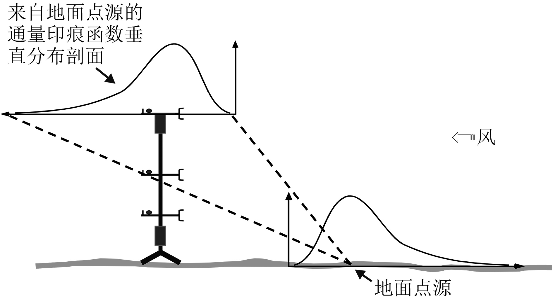
考虑“源区”影响的验证方法需要求解印痕(footprint)函数,又称为源权重函数,它是描述近地层表面源或汇的空间分布和仪器观测通量值之间关系的函数。印痕模型主要通过大气扩散理论,建立起仪器观测值与近地层表面源(汇)空间分布的传输关系,对观测区域内的地气之间能量与物质交换进行定量描述。它主要考虑的是观测通量的空间代表性,即仪器的测量值能在多大程度上反映实际下垫面的平均或累积状况。在通量观测数据的分析中有很大的实用价值,也是通量观测站址的选择与观测数据的质量评估以及遥感反演通量的验证等的重要工具(宫丽娟等,2009 ;双喜等,2009;贾贞贞等,2010)。
从计算方式上,印痕模型有数值分析与数值模拟;从对湍流的描述上,可分为欧拉和拉格朗日坐标系;从模型原理上,可分为以下4类(Schmid,2002; Vesala等,2008):(1)解析模型;(2)拉格朗日随机模型,又分为时间正向扩散模型和时间反向扩散模型;(3)基于大涡模拟的模型;(4)闭合模型。印痕模型中很重要的一个概念是倒置烟羽假设,其实质是使用单个地面点源的扩散性质去推出一定高度上的印痕分布(蔡旭晖,2008),然后假设所得到的印痕分布经对称变换后就是地面的印痕分布,具体见图 2(http://blog.yuntech.edu.tw/userfilev4/5007/Fetch-Footprtint-Schmid.ppt)。解析模型与时间正向扩散的拉格朗日模型都是基于倒置烟羽假设。
解析模型在倒置烟羽假设下,运用梯度扩散理论、2维平流扩散方程和相似理论计算通量贡献区。其代表有FASM(Schmid,1994)和欧拉完全解析模型(Kormann和Meixner,2001)。它计算简便,但是倒置烟羽假设要求湍流在水平方向上是均匀,限制了使用范围。拉格朗日随机模型用有限个粒子的运动轨迹代替气体的扩散过程,且这些粒子之间是完全相互独立的,通过随机扩散微分方程描述标量的扩散(张慧等,2012)。计算时间正向模型时,粒子释放源位于地面,通过倒置烟羽假设求解其地面的印痕函数空间分布;时间反向扩散则是粒子释放源位于观测点,在反向时间坐标下扩散;反向模型可应用于非均匀下垫面与非稳态流场;正向模型与反向模型在均匀条件下的计算结果一样。拉格朗日随机模型的缺点是需要模拟追踪大量的粒子,产生可靠的统计结果,使得计算时间较长;且需预定义欧拉风场及其概率密度函数,模型精度取决于风场的精度。大涡模拟和闭合模型本质上不属于印痕模型,需要求解Navier-Stokes方程,但是都可以推导出印痕函数。
4 结 论
综观近年来的遥感估算水热通量模型,相关研究已取得了长足进展,逐渐向多方法交叉结合的方向发展,其主要致力于解决的问题有两个,一是下垫面阻抗参数的计算,阻抗的计算方法很复杂,涉及到地表粗糙度等因素,为此也发展了很多的参数化方案;二是模型使用的温度问题,主要包括两个方面,是单源模型使用遥感表面辐射温度代替空气动力学温度计算显热通量,或是使用组分温度结合双源模型分解源汇。针对这两个大问题,在这些模型基本原理的基础上,学者们结合遥感科学的特点与优势,如各种植被指数与地面参数的关系(有些有明确物理涵义,有的属于半经验性),发展了由饱和下垫面向非饱和下垫面的地表蒸散遥感估算模型。
各种模型还存在很多问题:非线性模型自身存在的不确定性,而模型所需地表参数如地表温度、kB-1和阻抗等估算精度、时间尺度拓展等一直是难题,制约着遥感估算水热通量的精度。此外,如参考高度上的气温和水汽压等的气象参数,通过遥感获取还存在很大难度。因此,深入发展与完善反演常规气象要素的遥感算法,是提高遥感估算地表蒸散模型可操作性的基础;如动力粗糙度是影响水热通量估算精度非常敏感的参数,而新兴的LiDAR技术为获取区域尺度上更合理的粗糙度估计提供了观测手段(Colin和Faivre,2010; Tian等,2011;李新等,2012b)。
有很多方法可以定量化表达研究区域内某一变量的异质性或自相关性,如半变异函数(Garrigues等,2006)、分形分维法(Zhang等,2008,2010)和小波分析与信息论(Brunsell等,2008; Hintz等,2014)等。这是目前研究的热点,但是缺乏统一的衡量标准,也没有解释说明地表异质性的影响机理与物理涵义,如:空间异质性是如何影响空间分辨率与空间变异性之间的关系,输入参数的空间异质性是如何影响通量估算结果的,这些是未来研究需要考虑的问题。
空间尺度转换的研究已有一定基础,但还缺少系统性和整体性(李小文和王祎婷,2013)。根据先验知识,结合贝叶斯反演理论的构造地理趋势面或许有望解决尺度转换的难题(王祎婷等,2014)。然而,要将应用于其他遥感反演参量的尺度转换方法应用于估算水热通量仍然任重道远。李新(2014)用代表性误差的概念统一由尺度代表性所引起的误差,从不确定性的角度考虑陆地表层系统的高度空间异质性,提出应以随机的观点对待复杂的陆地表层系统并发展描述动力学系统统计分布的新一代模型。
在地面实验观测水热通量方面,有必要形成天地一体化的长期连续综合观测体系,以研究不同时空尺度的陆地系统水碳氮过程。如何通过实际观测及对有限观测资料的新处理方法的开发,深入研究如何获得区域尺度的地表土壤热通量、能量不闭合问题以及分析湍流的组织结构等问题都是将来的研究重点。进一步开展遥感不同像元尺度地表蒸散及验证方法研究、分析地面观测数据的空间代表性、完善验证像元的选取和评价指标的构建等也是十分必要的。
参考文献
-
Abtew W and Melesse A M. 2013. Evaporation and evapotranspiration: Measurements and Estimations. Netherlands: Springer [DOI: 10.1007/978-94-007-4737-1]
-
Agam N, Kustas W P, Anderson M C, Li F Q and Colaizzi P D. 2007a. Utility of thermal sharpening over Texas high plains irrigated agricultural fields. Journal of Geophysical Research: AtmOspheres, 112(D19): D19110 [DOI: 10.1029/2007JD008407]
-
Agam N, Kustas W P, Anderson M C, Li F Q and Neale C M U. 2007b. A vegetation index based technique for spatial sharpening of thermal imagery. Remote Sensing of Environment, 107(4): 545-558 [DOI: 10.1016/j.rse.2006.10.006]
-
Agam N, Kustas W P, Anderson M C, Li F Q and Colaizzi P D. 2008. Utility of thermal image sharpening for monitoring field-scale evapotranspiration over rainfed and irrigated agricultural regions. Geophysical Research Letters, 35(2): L02402 [DOI: 10.1029/2007GL032195]
-
Allen R G, Tasumi M and Trezza R. 2007. Satellite-based energy balance for mapping evapotranspiration with internalized calibration (METRIC)—model. Journal of Irrigation and Drainage Engineering, 133(4): 380-394 [DOI: 10.1061/(ASCE)0733-9437(2007) 133:4(380)]
-
Anderson M C, Norman J M, Diak G R, Kustas W P and Mecikalski J R. 1997. A two-source time-integrated model for estimating surface fluxes using thermal infrared remote sensing. Remote Sensing of Environment, 60(2): 195-216 [DOI: 10.1016/S0034-4257(96)00215-5]
-
Anderson M C, Norman J M, Mecikalski J R, Torn R D, Kustas W P and Basara J B. 2004. A multiscale remote sensing model for disaggregating regional fluxes to micrometeorological scales. Journal of Hydrometeorology, 5(2): 343-363 [DOI: 10.1175/1525-7541(2004) 005<0343:AMRSMF>2.0.CO;2]
-
Atkinson P M. 2013. Downscaling in remote sensing. International Journal of Applied Earth Observation and Geoinformation, 22: 106-114 [DOI: 10.1016/j.ag.2012.04.012]
-
Avissar R and Pielke R A. 1989. A Parameterization of heterogeneous land surfaces for atmospheric numerical models and its impact on regional meteorology. Monthly Weather Review, 117(10): 2113-2136 [DOI: 10.1175/1520-0493(1989)117<2113:APOHLS> 2.0.CO;2]
-
Avissar R. 1991. A statistical-dynamical approach to parameterize subgrid-scale land-surface heterogeneity in climate models //Land Surface-Atmosphere Interactions for Climate Modeling. Netherlands: Springer: 155-178 [DOI: 10.1007/978-94-009-2155-9_8]
-
Baklanov A A, Grisogono B, Bornstein R, Mahrt L, Zilitinkevich S S, Taylor P, Larsen S E, Rotach M W and Fernando H J S. 2011. The nature, theory, and modeling of atmospheric planetary boundary layers. Bulletin of the American Meteorological Society, 92(2): 123-128 [DOI: 10.1175/2010BAMS2797.1]
-
Barton I J. 1979. A parameterization of the evaporation from nonsaturated surfaces. Journal of Applied Meteorology, 18(1): 43-47 [DOI: 10.1175/1520-0450(1979)018<0043:APOTEF>2.0.CO;2]
-
Bastiaanssen W G M, Menenti M, Feddes R A and Holtslag A A M. 1998a. A remote sensing surface energy balance algorithm for land (SEBAL). 1. Formulation. Journal of Hydrology, 212-213: 198-212 [DOI: 10.1016/S0022-1694(98)00253-4]
-
Bastiaanssen W G M, Pelgrum H, Wang J, Ma Y, Moreno J F, Roerink G J and van der Wal T. 1998b. A remote sensing surface energy balance algorithm for land (SEBAL).: Part 2: Validation. Journal of Hydrology, 212-213: 213-229 [DOI: 10.1016/S0022-1694(98)00254-6]
-
Bateni S M and Liang S. 2012. Estimating surface energy fluxes using a dual-source data assimilation approach adjoined to the heat diffusion equation. Journal of Geophysical Research: Atmospheres, 117(D17): D17118 [DOI: 10.1029/2012JD017618]
-
Bindhu V M, Narasimhan B and Sudheer K P. 2013. Development and verification of a non-linear disaggregation method (NL-DisTrad) to downscale MODIS land surface temperature to the spatial scale of Landsat thermal data to estimate evapotranspiration. Remote Sensing of Environment, 135: 118-129 [DOI: 10.1016/j.rse.2013.03.023]
-
Blyth E M and Harding R J. 1995. Application of aggregation models to surface heat flux from the Sahelian tiger bush. Agricultural and Forest Meteorology, 72(3/4): 213-235 [DOI: 10.1016/0168-1923(94)02164-F]
-
Bolle H J, Andre J C, Arrue J L, Barth H K, Bessemoulin P, Brasa A, De Bruin H A R, Cruces J, Dugdale G, Engman E T, Evans D L, Fantechi R, Fiedler F, Van De Griend A, Imeson A C, Jochum A, Kabat P, Kratzsch T, Lagouarde J P, Langer I, Llamas R, Lopez-Baeza E, Miralles J M, Muniosguren L S, Nerry F, Noilhan J, Oliver H R, Roth R, Saatchi S S, Sanchez Diaz J, De Santa Olalla M, Shuttleworth W J, Søgaard H, Stricker H, Thornes J, Vauclin M and Wickland D. 1993. EFEDA: European field experiment in a desertification-threatened area. Annales Geophysicae, 11(2/3): 173-189
-
Bonan G B, Pollard D and Thompson S L. 1993. Influence of subgrid-scale heterogeneity in leaf area index, stomatal resistance, and soil moisture on grid-scale land–atmosphere interactions. Journal of Climate, 6(10): 1882-1897 [DOI: 10.1175/1520-0442(1993)006<1882:IOSSHI>2.0.CO;2]
-
Brunsell N A, Ham J M and Owensby C E. 2008. Assessing the multi-resolution information content of remotely sensed variables and elevation for evapotranspiration in a tall-grass prairie environment. Remote Sensing of Environment, 112(6): 2977-2987 [DOI: 10.1016/j.rse.2008.02.002]
-
Brutsaert W. 1982. Evaporation into the Atmosphere: Theory, History and Applications. Netherlands: Springer [DOI: 10.1007/978-94-017-1497-6]
-
Cai X H. 2008. Footprint analysis in mircometeorology and its extended applications. Chinese Journal of Atmospheric Sciences, 32(1): 123-132 (蔡旭晖. 2008. 湍流微气象观测的印痕分析方法及其应用拓展. 大气科学, 32(1): 123-132)
-
Carlson T. 2007. An overview of the “Triangle Method” for estimating surface evapotranspiration and soil moisture from satellite imagery. Sensors (Basel), 7(8): 1612-1629 [DOI: 10.3390/s7081612]
-
Carlson T N, Capehart W J and Gillies R R. 1995a. A new look at the simplified method for remote sensing of daily evapotranspiration. Remote Sensing of Environment, 54(2): 161-167 [DOI: 10.1016/0034-4257(95)00139-R]
-
Carlson T N, Gillies R R and Schmugge T J. 1995b. An interpretation of methodologies for indirect measurement of soil water content. Agricultural and Forest Meteorology, 77(3/4): 191-205 [DOI: 10.1016/0168-1923(95)02261-U]
-
Chahine M T. 1992. GEWEX: the global energy and water cycle experiment. Eos, Transactions American Geophysical Union, 73(2): 9-14 [DOI: 10.1029/91EO00007]
-
Chehbouni A, Lo Seen D, Njoku E G and Monteny B M. 1996. Examination of the difference between radiative and aerodynamic surface temperatures over sparsely vegetated surfaces. Remote Sensing of Environment, 58(2): 177-186 [DOI: 10.1016/S0034-4257(96)00037-5]
-
Chen B, Ding Y G, Liu J M and Zhang Y C. 2008. Review on research of parameterization of heterogeneous land surface process. Plateau Meteorology, 27(5): 1172-1180 (陈斌, 丁裕国, 刘晶淼, 张耀存. 2008. 非均匀地表陆面过程参数化研究. 高原气象, 27(5): 1172-1180)
-
Chen B Z, Chen J M, Mo G, Yuen C W, Margolis H, Higuchi K and Chan D. 2007. Modeling and scaling coupled energy, water, and carbon fluxes based on remote sensing: an application to Canada’s landmass. Journal of Hydrometeorology, 8(2): 123-143 [DOI: 10.1175/JHM566.1]
-
Chen J, Chen B Z, Black T A, Innes J L, Wang G Y, Kiely G, Hirano T and Wohlfahrt G. 2013a. Comparison of terrestrial evapotranspiration estimates using the mass transfer and Penman-Monteith equations in land surface models. Journal of Geophysical Research: Biogeosciences, 118(4): 1715-1731 [DOI: 10.1002/2013jg002446]
-
Chen J M. 1988. An important drawback and the improvement of the evapotranspiration model with remote sensing. Chinese Science Bulletin, (6): 454-457 (陈镜明. 1988. 现用遥感蒸散模式中的一个重要缺点及改进. 科学通报, (6): 454-457)
-
Chen J M. 1999. Spatial scaling of a remotely sensed surface parameter by contexture. Remote Sensing of Environment, 69(1): 30-42 [DOI: 10.1016/S0034-4257(99)00006-1]
-
Chen J M, Chen X and Ju W. 2013b. Effects of vegetation heterogeneity and surface topography on spatial scaling of net primary productivity. Biogeosciences, 10(7): 4879-4896 [DOI: 10.5194/bg-10-4879-2013]
-
Chen S H and Su H B. 2014. An eigenpoint based multiscale method for validating quantitative remote sensing products. Advances in Meteorology, 2014: Article ID 692313 [DOI: 10.1155/2014/692313]
-
Choudhury B J, Reginato R J and Idso S B. 1986. An analysis of infrared temperature observations over wheat and calculation of latent heat flux. Agricultural and Forest Meteorology, 37(1): 75-88, [DOI: 10.1016/0168-1923(86)90029-8]
-
Cleugh H A, Leuning R, Mu Q Z and Running S W. 2007. Regional evaporation estimates from flux tower and MODIS satellite data. Remote Sensing of Environment, 106(3): 285-304 [DOI: 10.1016/j.rse.2006.07.007]
-
Colin J and Faivre R. 2010. Aerodynamic roughness length estimation from very high-resolution imaging LIDAR observations over the Heihe basin in China. Hydrology and Earth System Sciences, 14(12): 2661-2669 [DOI: 10.5194/hess-14-2661-2010]
-
Coughlan M and Avissar R. 1996. The global energy and water cycle experiment (GEWEX) continental-scale international project (GCIP): an overview. Journal of Geophysical Research: Atmospheres, 101(D3): 7139-7147 [DOI: 10.1029/96JD00125]
-
Davies J A and Allen C D. 1973. Equilibrium, potential and actual evaporation from cropped surfaces in Southern Ontario. Journal of Applied Meteorology, 12(4): 649-657 [DOI: 10.1175/1520-0450(1973) 012<0649:EPAAEF>2.0.CO;2]
-
Dominguez A, Kleissl J, Luvall J C and Rickman D L. 2011. High-resolution urban thermal sharpener (HUTS). Remote Sensing of Environment, 115(7): 1772-1780 [DOI: 10.1016/j.rse.2011.03.008]
-
El Maayar E and Chen J M. 2006. Spatial scaling of evapotranspiration as affected by heterogeneities in vegetation, topography, and soil texture. Remote Sensing of Environment, 102(1/2): 33-51 [DOI: 10.1016/j.rse.2006.01.017]
-
Ershadi A, McCabe M F, Evans J P and Walker J P. 2013. Effects of spatial aggregation on the multi-scale estimation of evapotranspiration. Remote Sensing of Environment, 131: 51-62 [DOI: 10.1016/j.rse.2012.12.007]
-
Fasbender D, Tuia D, Bogaert P and Kanevski M. 2008. Support-based implementation of bayesian data fusion for spatial enhancement: applications to ASTER thermal images. IEEE Geoscience and Remote Sensing Letters, 5(4): 598-602 [DOI: 10.1109/LGRS.2008.2000739]
-
Fisher J B, Tu K P and Baldocchi D D. 2008. Global estimates of the land-atmosphere water flux based on monthly AVHRR and ISLSCP-II data, validated at 16 FLUXNET sites. Remote Sensing of Environment, 112(3): 901-919 [DOI: 10.1016/j.rse.2007.06.025]
-
Garrigues S, Allard D, Baret F and Weiss M. 2006. Quantifying spatial heterogeneity at the landscape scale using variogram models. Remote Sensing of Environment, 103(1): 81-96 [DOI: 10.1016/j.rse.2006.03.013]
-
Ge Y, Liang Y Z, Wang J H, Zhao Q Y and Liu S M. 2015. Upscaling sensible heat fluxes with area-to-area regression kriging. IEEE Geoscience and Remote Sensing Letters, 12(3): 656-660 [DOI: 10.1109/LGRS.2014.2355871]
-
Gebremichael M, Wang J M and Sammis T W. 2010. Dependence of remote sensing evapotranspiration algorithm on spatial resolution. Atmospheric Research, 96(4): 489-495 [DOI: 10.1016/j.atmosres.2009.12.003]
-
Giorgi F. 1997a. An Approach for the representation of surface heterogeneity in land surface models. Part I: theoretical framework. Monthly Weather Review, 125(8): 1885-1899 [DOI: 10.1175/1520-0493(1997)125<1885:AAFTRO>2.0.CO;2]
-
Giorgi F. 1997b. An approach for the representation of surface heterogeneity in land surface models. Part II: validation and sensitivity experiments. Monthly Weather Review, 125(8): 1900-1919 [DOI: 10.1175/1520-0493(1997)125<1900:AAFTRO>2.0.CO;2]
-
Glenn E P, Huete A R, Nagler P L, Hirschboeck K K and Brown P. 2007. Integrating remote sensing and ground methods to estimate evapotranspiration. Critical Reviews in Plant Sciences, 26(3): 139-168 [DOI: 10.1080/07352680701402503]
-
Gong L J, Liu S M, Shuang X, Cai X H and Xu Z W. 2009. Investigation of spatial representativeness for surface flux measurements with eddy covariance system and large aperture scintillometer. Plateau Meteorology, 28(2): 246-257 (宫丽娟, 刘绍民, 双喜, 蔡旭晖, 徐自为. 2009. 涡动相关仪和大孔径闪烁仪观测通量的空间代表性. 高原气象, 28(2): 246-257)
-
Hintz M, Lennartz-Sassinek S, Liu S F and Shao Y P. 2014. Quantification of land-surface heterogeneity via entropy spectrum method. Journal of Geophysical Research: Atmospheres, 119(14): 8764-8777 [DOI: 10.1002/2014JD021825]
-
Hong S H, Hendrickx J M H and Borchers B. 2009. Up-scaling of SEBAL derived evapotranspiration maps from Landsat (30m) to MODIS (250m) scale. Journal of Hydrology, 370(1/4): 122-138 [DOI: 10.1016/j.jhydrol.2009.03.002]
-
Hong W and Wang Y Y. 2010. Review of researches on atmospheric boundary layer over heterogeneous underlying surface. Journal of Nanjing University of Information Science and Technology (Natural Science Edition), 2(2): 155-161 (洪雯, 王毅勇. 2010. 非均匀下垫面大气边界层研究进展. 南京信息工程大学学报 (自然科学版), 2(2): 155-161)
-
Hu Y Q, Gao Y X, Wang J M, Ji G L, Shen Z B, Cheng L C, Chen J Y and Li S Q. 1994. Some achievements in scientific research during HEIFE. Plateau Meteorology, 13(3): 225-236 (胡隐樵, 高由禧, 王介民, 季国良, 沈志宝, 程麟生, 陈家宜, 李守谦. 1994. 黑河实验(HEIFE)的一些研究成果. 高原气象, 13(3): 225-236)
-
Hu Z L and Islam S. 1997. A framework for analyzing and designing scale invariant remote sensing algorithms. IEEE Transactions on Geoscience and Remote Sensing, 35(3): 747-755 [DOI: 10.1109/36.581996]
-
Jackson R D, Reginato R J and Idso S B. 1977. Wheat canopy temperature: a practical tool for evaluating water requirements. Water Resources Research, 13(3): 651-656 [DOI: 10.1029/WR013i0- 03p00651]
-
Jacobs C M J and de Bruin H A R. 1997. Predicting regional transpiration at elevated atmospheric CO2: influence of the PBL–vegetation interaction. Journal of Applied Meteorology, 36(12): 1663-1675 [DOI: 10.1175/1520-0450(1997)036<1663:PRTAEA> 2.0.CO;2]
-
Jia Z Z, Liu S M, Mao D F, Wang Z L, Xu Z W and Zhang R. 2010. A study of the validation method of remotely sensed evapotranspiration based on observation data. Advances in Earth Science, 25(11): 1248-1260 (贾贞贞, 刘绍民, 毛德发, 王志良, 徐自为, 张茹. 2010. 基于地面观测的遥感监测蒸散量验证方法研究. 地球科学进展, 25(11): 1248-1260)
-
Jia Z Z, Liu S M, Xu Z W, Chen Y J and Zhu M J. 2012. Validation of remotely sensed evapotranspiration over the Hai River Basin, China. Journal of Geophysical Research: Atmospheres, 117(D13): D13113 [DOI: 10.1029/2011JD017037]
-
Jiang L and Islam S. 1999. A methodology for estimation of surface evapotranspiration over large areas using remote sensing observations. Geophysical Research Letters, 26(17): 2773-2776 [DOI: 10.1029/1999GL006049]
-
Jiang L and Islam S. 2001. Estimation of surface evaporation map over Southern Great Plains using remote sensing data. Water Resources Research, 37(2): 329-340 [DOI: 10.1029/2000WR- 900255]
-
Jiao J J, Xin X Z, Yu S S, Zhou T and Peng Z Q. 2014. Estimation of surface energy balance from HJ-1 satellite data. Journal of Remote Sensing, 18(5): 1048-1058 (矫京均, 辛晓洲, 余珊珊, 周倜, 彭志晴. 2014. HJ-1卫星数据估算地表能量平衡. 遥感学报, 18(5): 1048-1058) [DOI: 10.11834/jrs.20143322]
-
Jin R, Li X, Yan B P, Luo W M, Li X H, Guo J W, Ma M G, Kang J and Zhang Y L. 2012. Introduction of eco-hydrological wireless sensor network in the Heihe River Basin. Advances in Earth Sciences, 27(9): 993-1005 (晋锐, 李新, 阎保平, 罗万明, 李秀红, 郭建文, 马明国, 亢健, 张艳林. 2012. 黑河流域生态水文传感器网络设计. 地球科学进展, 27(9): 993-1005)
-
Jin Y F, Randerson J T and Goulden M L. 2011. Continental-scale net radiation and evapotranspiration estimated using MODIS satellite observations. Remote Sensing of Environment, 115(9): 2302-2319 [DOI: 10.1016/j.rse.2011.04.031]
-
Jin Z, Tian Q, Chen J M and Chen M. 2007. Spatial scaling between leaf area index maps of different resolutions. Journal of Environmental Management, 85(3): 628-637 [DOI: 10.1016/j.jenvman.2006.08.016]
-
Ju Y Q, Xu Z W, Liu S M, Lu L, Xu T R and Liu S D. 2014. Study on kB-1 on farmland and grass underlying surfaces. Plateau Meteorology, 33(1): 55-65 (鞠英芹, 徐自为, 刘绍民, 卢俐, 徐同仁, 刘寿东. 2014. 农田和草地下垫面上附加阻尼kB-1变化特征的分析. 高原气象, 33(1): 55-65)
-
Jung M, Reichstein M, Ciais P, Seneviratne S I, Sheffield J, Goulden M L, Bonan G, Cescatti A, Chen J Q, de Jeu R, Dolman A J, Eugster W, Gerten D, Gianelle D, Gobron N, Heinke J, Kimball J, Law B E, Montagnani L, Mu Q Z, Mueller B, Oleson K, Papale D, Richardson A D, Roupsard O, Running S, Tomelleri E, Viovy N, Weber U, Williams C, Wood E, Zaehle S and Zhang K. 2010. Recent decline in the global land evapotranspiration trend due to limited moisture supply. Nature, 467(7318): 951-954 [DOI: 10.1038/nature09396]
-
Kalma J D, McVicar T R and McCabe M F. 2008. Estimating land surface evaporation: a review of methods using remotely sensed surface temperature data. Surveys in Geophysics, 29(4/5): 421-469 [DOI: 10.1007/s10712-008-9037-z]
-
Kimball J S, Running S W and Saatchi S S. 1999. Sensitivity of boreal forest regional water flux and net primary production simulations to sub-grid-scale land cover complexity. Journal of Geophysical Research: Atmospheres, 104(D22): 27789-27801 [DOI: 10.1029/1999JD900085]
-
Kormann R and Meixner F X. 2001. An analytical footprint model for non-neutral stratification. Boundary-Layer Meteorology, 99(2): 207-224 [DOI: 10.1023/A:1018991015119]
-
Kustas W P, Choudhury B J, Moran M S, Reginato R J, Jackson R D, Gay L W and Weaver H L. 1989. Determination of sensible heat flux over sparse canopy using thermal infrared data. Agricultural and Forest Meteorology, 44(3/4): 197-216 [DOI: 10.1016/0168-1923(89)90017-8]
-
Kustas W P and Norman J M. 1997. A two-source approach for estimating turbulent fluxes using multiple angle thermal infrared observations. Water Resources Research, 33(6): 1495-1508 [DOI: 10.1029/97WR00704]
-
Kustas W P and Norman J M. 1999. Evaluation of soil and vegetation heat flux predictions using a simple two-source model with radiometric temperatures for partial canopy cover. Agricultural and Forest Meteorology, 94(1): 13-29 [DOI: 10.1016/S0168-1923(99)00005-2]
-
Kustas W P and Norman J M. 2000. Evaluating the effects of subpixel heterogeneity on pixel average fluxes. Remote Sensing of Environment, 74(3): 327-342 [DOI: 10.1016/S0034-4257(99)00081-4]
-
Kustas W P, Norman J M, Anderson M C and French A N. 2003. Estimating subpixel surface temperatures and energy fluxes from the vegetation index–radiometric temperature relationship. Remote Sensing of Environment, 85(4): 429-440 [DOI: 10.1016/S0034-4257(03)00036-1]
-
Leuning R, Zhang Y Q, Rajaud A, Cleugh H and Tu K. 2008. A simple surface conductance model to estimate regional evaporation using MODIS leaf area index and the Penman-Monteith equation. Water Resources Research, 44(10): W10419 [DOI: 10.1029/2007WR- 006562]
-
Lhomme J P, Monteny B and Amadou M. 1994. Estimating sensible heat flux from radiometric temperature over sparse millet. Agricultural and Forest Meteorology, 68(1/2): 77-91 [DOI: 10.1016/0168-1923(94)90070-1]
-
Li X, Huang C L, Che T, Jin R, Wang S G, Wang J M, Gao F, Zhang S W, Qiu C J and Wang C H. 2007. Development of a Chinese land data assimilation system: its progress and prospects. Progress in Natural Science, 17(2): 163-173 (李新, 黄春林, 车涛, 晋锐, 王书功, 王介民, 高峰, 张述文, 邱崇践, 王澄海. 2007. 中国陆面数据同化系统研究的进展与前瞻. 自然科学进展, 17(2): 163-173)
-
Li X, Ma M G, Wang J, Liu Q, Che T, Hu Z Y, Xiao Q, Liu Q H, Su P X, Chu R Z, Jin R, Wang W Z and Ran Y H. 2008. Simultaneous remote sensing and ground-based experiment in the Heihe River Basin: scientific objectives and experiment design. Advances in Earth Science, 23(9): 897-914 (李新, 马明国, 王建, 刘强, 车涛, 胡泽勇, 肖青, 柳钦火, 苏培玺, 楚荣忠, 晋锐, 王维真, 冉有华. 2008. 黑河流域遥感-地面观测同步实验: 科学目标与实验方案. 地球科学进展, 23(9): 897-914)
-
Li X, Li X W, Li Z Y, Ma M G, Wang J, Xiao Q, Liu Q, Che T, Chen E X, Yan G J, Hu Z Y, Zhang L X, Chu R Z, Su P X, Liu Q H, Liu S M, Wang J D, Niu Z, Chen Y, Jin R, Wang W Z, Ran Y H, Xin X Z and Ren H Z. 2009a. Watershed allied telemetry experimental research. Journal of Geophysical Research: Atmospheres, 114(D22): D22103 [DOI: 10.1029/2008JD011590]
-
Li X, Li X W, Li Z Y, Wang J, Ma M G, Liu Q, Xiao Q, Hu Z Y, Che T, Wang J M, Liu Q H, Chen E X, Yan G J, Liu S M, Wang W Z, Zhang L X, Wang J D, Niu Z, Jin R, Ran Y H and Wang L X. 2012a. Progresses on the watershed allied telemetry experimental research (WATER). Remote Sensing Technology and Application, 27(5): 637-649 (李新, 李小文, 李增元, 王建, 马明国, 刘强, 肖青, 胡泽勇, 车涛, 王介民, 柳钦火, 陈尔学, 阎广建, 刘绍民, 王维真, 张立新, 王锦地, 牛铮, 晋锐, 冉有华, 王亮绪. 2012a. 黑河综合遥感联合实验研究进展: 概述. 遥感技术与应用, 27(5): 637-649) [DOI: 10.11873/j.issn.1004-0323.2012.5.637]
-
Li X, Liu Q, Liu Q H, Wang J, Ma M G, Xiao Q, Che T, Jin R and Ran Y H. 2012b. The progresses on the watershed allied telemetry experimental research (WATER): remote sensing of key hydrological and ecological parameters. Remote Sensing Technology and Application, 27(5): 650-662 (李新, 刘强, 柳钦火, 王建, 马明国, 肖青, 车涛, 晋锐, 冉有华. 2012b. 黑河综合遥感联合实验研究进展: 水文与生态参量遥感反演与估算. 遥感技术与应用, 27(5): 650-662) [DOI: 10.11873/j.issn.1004-0323.2012.5.650]
-
Li X, Liu S M, Ma M G, Xiao Q, Liu Q H, Jin R, Che T, Wang W Z, Qi Y, Li H Y, Zhu G F, Guo J W, Ran Y H, Wen J G and Wang S G. 2012c. HiWATER: an integrated remote sensing experiment on hydrological and ecological processes in the Heihe River Basin. Advances in Earth Science, 27(5): 481-498 (李新, 刘绍民, 马明国, 肖青, 柳钦火, 晋锐, 车涛, 王维真, 祁元, 李弘毅, 朱高峰, 郭建文, 冉有华, 闻建光, 王树果. 2012c. 黑河流域生态-水文过程综合遥感观测联合实验总体设计. 地球科学进展, 27(5): 481-498)
-
Li X. 2014. Characterization, controlling, and reduction of uncertainties in the modeling and observation of land-surface systems. Science China: Earth Sciences, 57(1): 80-87 (李新. 2013. 陆地表层系统模拟和观测的不确定性及其控制. 中国科学: 地球科学, 43(11): 1735-1742) [DOI: 10.1007/s11430-013-4728-9]
-
Li X, Cheng G D, Liu S M, Xiao Q, Ma M G, Jin R, Che T, Liu Q H, Wang W Z, Qi Y, Wen J G, Li H Y, Zhu G F, Guo J W, Ran Y H, Wang S G, Zhu Z L, Zhou J, Hu X L and Xu Z W. 2013. Heihe watershed allied telemetry experimental research (HiWATER): scientific objectives and experimental design. Bulletin of the American Meteorological Society, 94(8): 1145-1160 [DOI: 10.1175/BAMS-D-12-00154.1]
-
Li X W and Wang Y T. 2013. Prospects on future developments of quantitative remote sensing. Acta Geographica Sinica, 68(9): 1163-1169 (李小文, 王祎婷. 2013. 定量遥感尺度效应刍议. 地理学报, 68(9): 1163-1169) [DOI: 10.11821/dlxb201309001]
-
Li Z L, Tang R L, Wan Z M, Bi Y Y, Zhou C H, Tang B H, Yan G J and Zhang X Y. 2009b. A review of current methodologies for regional evapotranspiration estimation from remotely sensed data. Sensors, 9(5): 3801-3853 [DOI: 10.3390/s90503801]
-
Liu D S and Pu R L. 2008. Downscaling thermal infrared radiance for subpixel land surface temperature retrieval. Sensors, 8(4): 2695-2706 [DOI: 10.3390/s8042695]
-
Liu J M, Wang J J and Ding Y G. 2002. A simplified PDF for computing regional mean flux over heterogeneous surface and its application. Plateau Meteorology, 21(6): 583-590 (刘晶淼, 王纪军, 丁裕国. 2002. 计算非均匀地表通量的一种简化PDF及其应用. 高原气象, 21(6): 583-590)
-
Liu J M, Ding Y G, Zhou X J and Wang F. 2003. The influence of land surface heterogeneity on parameterization of regional mean water vapor flux. Acta Meteorologica Sinica, 61(6): 712-717 (刘晶淼, 丁裕国, 周秀骥, 汪方. 2003. 地表非均匀性对区域平均水分通量参数化的影响. 气象学报, 61(6): 712-717)
-
Liu S M. 1998. Calculation of actual evapotranspiration for cotton field by means of the Priestley-Taylor model. Quarterly Journal of Applied Meteorology, 9(1): 88-93 (刘绍民. 1998. 用Priestley-Taylor模式计算棉田实际蒸散量的研究. 应用气象学报, 9(1): 88-93)
-
Liu S M, Sun R, Sun Z P, Li X W and Liu C M. 2004. Comparison of different complementary relationship models for regional evapotranspiration estimation. Acta Geographica Sinica, 59(3): 331-340 (刘绍民, 孙睿, 孙中平, 李小文, 刘昌明. 2004. 基于互补相关原理的区域蒸散量估算模型比较. 地理学报, 59(3): 331-340) [DOI: 10.11821/xb200403002]
-
Liu S M, Sun R, Sun Z P, Li X W and Liu C M. 2006. Evaluation of three complementary relationship approaches for evapotranspiration over the Yellow River basin. Hydrological processes, 20(11): 2347-2361 [DOI: 10.1002/hyp.6048]
-
Liu Y N, Wu J J, Xia H and Fan J L. 2005. Summary of two-layer models on estimating evapotranspiration using quantitative parameters derived from remote sensing. Arid Land Geography, 28(1): 65-71 (刘雅妮, 武建军, 夏虹, 范锦龙. 2005. 地表蒸散遥感反演双层模型的研究方法综述. 干旱区地理, 28(1): 65-71)
-
Long D and Singh V P. 2012a. A modified surface energy balance algorithm for land (M-SEBAL) based on a trapezoidal framework. Water Resources Research, 48(2): W02528 [DOI: 10.1029/2011 WR010607]
-
Long D and Singh V P. 2012b. A Two-source Trapezoid Model for Evapotranspiration (TTME) from satellite imagery. Remote Sensing of Environment, 121: 370-388 [DOI: 10.1016/j.rse.2012.02.015]
-
Loukas A, Vasiliades L, Domenikiotis C and Dalezios N R. 2005. Basin-wide actual evapotranspiration estimation using NOAA/AVHRR satellite data. Physics and Chemistry of the Earth, Parts A/B/C, 30(1/3): 69-79 [DOI: 10.1016/j.pce.2004.08.023]
-
Lu L, Liu S M, Xu Z W, Bai J and Wang J M. 2010. The scale relationship of sensible heat flux measured by large aperture scintillometer and eddy covariance system. Advances in Earth Science, 25(11): 1273-1282 (卢俐, 刘绍民, 徐自为, 白洁, 王介民. 2010. 大孔径闪烁仪和涡动相关仪观测显热通量之间的尺度关系. 地球科学进展, 25(11): 1273-1282)
-
Lv D R, Chen Z Z, Chen J Y, Wang G C, Ji J J, Chen H B, Liu Z L, Zhang R H, Qiao J S and Chen Y J. 2002. Composite study on Inner Mongolia semi-arid grassland soil-vegetation-atmosphere interaction (IMGRASS). Earth Science Frontiers (China University of Geosciences; Beijing), 9(2): 295-306 (吕达仁, 陈佐忠, 陈家宜, 王庚辰, 季劲钧, 陈洪滨, 刘钟龄, 张仁华, 乔劲松, 陈有君. 2002. 内蒙古半干旱草原土壤植被大气相互作用(IMGRASS)综合研究. 地学前缘(中国地质大学; 北京), 9(2): 295-306)
-
Margulis S A, Kim J and Hogue T. 2005. A comparison of the triangle retrieval and variational data assimilation methods for surface turbulent flux estimation. Journal of Hydrometeorology, 6(6): 1063-1072 [DOI: 10.1175/JHM451.1]
-
McCabe M F and Wood E F. 2006. Scale influences on the remote estimation of evapotranspiration using multiple satellite sensors. Remote Sensing of Environment, 105(4): 271-285 [DOI: 10.1016/j.rse.2006.07.006]
-
Mecikalski J R, Diak G R, Anderson M C and Norman J M. 1999. Estimating fluxes on continental scales using remotely sensed data in an atmospheric-land exchange model. Journal of Applied Meteorology, 38(9): 1352-1369 [DOI: 10.1175/1520-0450(1999)038<1352:EFOCSU>2.0.CO;2]
-
Monteith J L. 1965. Evaporation and environment. Symposia of the Society for Experimental Biology, 19: 205-234
-
Moran M S, Rahman A F, Washburne J C, Goodrich D C, Weltz M A and Kustas W P. 1996. Combining the Penman-Monteith equation with measurements of surface temperature and reflectance to estimate evaporation rates of semiarid grassland. Agricultural and Forest Meteorology, 80(2/4): 87-109 [DOI: 10.1016/0168-1923(95)02292-9]
-
Moran M S, Humes K S and Pinter P J Jr. 1997. The scaling characteristics of remotely-sensed variables for sparsely-vegetated heterogeneous landscapes. Journal of Hydrology, 190(3/4): 337-362 [DOI: 10.1016/S0022-1694(96)03133-2]
-
Mu Q Z, Heinsch F A, Zhao M S and Running S W. 2007. Development of a global evapotranspiration algorithm based on MODIS and global meteorology data. Remote Sensing of Environment, 111(4): 519-536 [DOI: 10.1016/j.rse.2007.04.015]
-
Mu Q Z, Zhao M S and Running S W. 2011. Improvements to a MODIS global terrestrial evapotranspiration algorithm. Remote Sensing of Environment, 115(8): 1781-1800 [DOI: 10.1016/j.rse.2011.02.019]
-
Mukammal E I and Neumann H H. 1977. Application of the Priestley-Taylor evaporation model to assess the influence of soil moisture on the evaporation from a large weighing lysimeter and class a pan. Boundary-Layer Meteorology, 12(2): 243-256 [DOI: 10.1007/BF00121976]
-
Mukherjee S, Joshi P K and Garg R D. 2014. A comparison of different regression models for downscaling Landsat and MODIS land surface temperature images over heterogeneous landscape. Advances in Space Research, 54(4): 655-669 [DOI: 10.1016/j.asr.2014.04.013]
-
Nemani R R and Running S W. 1989. Estimation of regional surface resistance to evapotranspiration from NDVI and Thermal-IR AVHRR data. Journal of Applied Meteorology, 28(4): 276-284 [DOI: 10.1175/1520-0450(1989)028<0276:EORSRT>2.0.CO;2]
-
Noilhan J and Planton S. 1989. A simple parameterization of land surface processes for meteorological models. Monthly Weather Review, 117(3): 536- 549 [DOI: 10.1175/1520-0493(1989)117 <0536:ASPOLS>2.0.CO;2]
-
Norman J M, Kustas W P and Humes K S. 1995. Source approach for estimating soil and vegetation energy fluxes in observations of directional radiometric surface temperature. Agricultural and Forest Meteorology, 77(3/4): 263-293 [DOI: 10.1016/0168-1923(95)02265-Y]
-
Norman J M, Anderson M C, Kustas W P, French A N, Mecikalski J, Torn R, Diak G R, Schmugge T J and Tanner B C W. 2003. Remote sensing of surface energy fluxes at 101-m pixel resolutions. Water Resources Research, 39(8): 1221 [DOI: 10.1029/2002WR001775]
-
Oncley S P, Foken T, Vogt R, Kohsiek W, DeBruin H A R, Bernhofer C, Christen A, van Gorsel E, Grantz D, Feigenwinter C, Lehner I, Liebethal C, Liu H P, Mauder M, Pitacco A, Ribeiro L and Weidinger T. 2007. The energy balance experiment EBEX-2000. Part I: overview and energy balance. Boundary-Layer Meteorology, 123(1): 1-28 [DOI: 10.1007/s10546-007-9161-1]
-
Peng G L, Liu S M, Cai X H, Lu L and Xu Z W. 2008. Footprint analysis of turbulent flux measurement over heterogeneous surface. Chinese Journal of Atmospheric Science, 32(5): 1064-1070 (彭谷亮, 刘绍民, 蔡旭晖, 卢俐, 徐自为. 2008. 非均匀下垫面湍流通量观测的印痕分析. 大气科学, 32(5): 1064-1070)
-
Penman H L. 1948. Natural Evaporation from Open Water, Bare Soil and Grass. Proceedings of the Royal Society A: Mathematical, Physical and Engineering Sciences, 193(1032): 120-145 [DOI: 10.1098/rspa.1948.0037]
-
Petropoulos G P. 2013. Remote Sensing of Energy Fluxes and Soil Moisture Content. Boca Raton, Florida: CRC Press
-
Priestley C H B and Taylor R J. 1972. On the assessment of surface heat flux and evaporation using large-scale parameters. Monthly Weather Review, 100(2): 81-92 [DOI: 10.1175/1520-0493(1972) 100<0081:OTAOSH>2.3.CO;2]
-
Prince S D, Kerr Y H, Goutorbe J P, Lebel T, Tinga A, Bessemoulin P, Brouwer J, Dolman A J, Engman E T, Gash J H C, Hoepffner M, Kabat P, Monteny B, Said F, Sellers P and Wallace J. 1995. Geographical, biological and remote sensing aspects of the hydrologic atmospheric pilot experiment in the sahel (HAPEX-Sahel). Remote Sensing of Environment, 51(1): 215-234 [DOI: 10.1016/0034-4257(94)00076-Y]
-
Quan J L, Zhan W F, Chen Y H and Liu W Y. 2013. Downscaling remotely sensed land surface temperatures: a comparison of typical methods. Journal of Remote Sensing, 17(2): 361-387 (全金玲, 占文凤, 陈云浩, 刘闻雨. 2013. 遥感地表温度降尺度方法比较——性能对比及适应性评价. 遥感学报, 17(2): 374-387) [DOI: 10.11834 /jrs.20132007]
-
Rodriguez-Galiano V, Pardo-Iguzquiza E, Sanchez-Castillo M, Chica-Olmo M and Chica-Rivas M. 2012. Downscaling Landsat 7 ETM+ thermal imagery using land surface temperature and NDVI images. International Journal of Applied Earth Observation and Geoinformation, 18: 515-527 [DOI: 10.1016/j.jag.2011.10.002]
-
Schmid H P. 1994. Source areas for scalars and scalar fluxes. Boundary-Layer Meteorology, 67(3): 293-318 [DOI:10.1007/BF00713146]
-
Schmid H P. 2002. Footprint modeling for vegetation atmosphere exchange studies: a review and perspective. Agricultural and Forest Meteorology, 113(1/4): 159-183 [DOI: 10.1016/S0168-1923(02)00107-7]
-
Seguin B and Itier B. 1983. Using midday surface temperature to estimate daily evaporation from satellite thermal IR data. International Journal of Remote Sensing, 4(2): 371-383 [DOI: 10.1080/01431168308948554]
-
Sellers P J, Hall F G, Asrar G, Strebel D E and Murphy R E. 1988. The first ISLSCP field experiment (FIFE). Bulletin of the American Meteorological Society, 69(1): 22-27 [DOI: 10.1175/1520-0477(1988) 069<0022:TFIFE>2.0.CO;2]
-
Sellers P J, Hall F G, Asrar G, Strebel D E and Murphy R E. 1992. An overview of the first international satellite land surface climatology project (ISLSCP) field experiment (FIFE). Journal of Geophysical Research: Atmospheres, 97(D17): 18345-18371 [DOI: 10.1029/92JD02111]
-
Shao Y, Sogalla M, Kerschgens M and Brücher W. 2001. Effects of land-surface heterogeneity upon surface fluxes and turbulent conditions. Meteorology and Atmospheric Physics, 78(3/4): 157-181 [DOI: 10.1007/s703-001-8171-3]
-
Shuang X, Liu S M, Xu Z W and Wang W Z. 2009. Investigation of spatial representativeness for surface flux measurements in the Heihe River Basin. Advances in Earth Science, 24(7): 724-733 (双喜, 刘绍民, 徐自为, 王维真. 2009. 黑河流域观测通量的空间代表性研究. 地球科学进展, 24(7): 724-733)
-
Shukla J and Mintz Y. 1982. Influence of land-surface evapotranspiration on the Earth's climate. Science, 215(4539): 1498-1501
-
Shuttleworth W J and Wallace J S. 1985. Evaporation from sparse crops-an energy combination theory. Quarterly Journal of the Royal Meteorological Society, 111(469): 839-855
-
Simic A, Chen J M, Liu J and Csillag F. 2004. Spatial scaling of net primary productivity using subpixel information. Remote Sensing of Environment, 93(1/2): 246-258 [DOI: 10.1016/j.rse.2004.07.008]
-
Song Y, Wang J M, Yang K, Ma M G, Li X, Zhang Z H and Wang X F. 2012. A revised surface resistance parameterisation for estimating latent heat flux from remotely sensed data. International Journal of Applied Earth Observation and Geoinformation, 17: 76-84 [DOI: 10.1016/j.jag.2011.10.011]
-
Stathopoulou M and Cartalis C. 2009. Downscaling AVHRR land surface temperatures for improved surface urban heat island intensity estimation. Remote Sensing of Environment, 113(12): 2592-2605 [DOI: 10.1016/j.rse.2009.07.017]
-
Stull R B. 1991. An Introduction to Boundary Layer Meteorology. Beijing: Meteorological Press (Stull R B. 1991. 边界层气象学导论. 北京: 气象出版社)
-
Su Z. 2002. The surface energy balance system (SEBS) for estimation of turbulent heat fluxes. Hydrology and Earth System Sciences, 6(1): 85-100 [DOI: 10.5194/hess-6-85-2002]
-
Sun L, Liang S L, Yuan W P and Chen Z X. 2013. Improving a Penman-Monteith evapotranspiration model by incorporating soil moisture control on soil evaporation in semiarid areas. International Journal of Digital Earth, 6(Sup1): 134-156 [DOI: 10.1080/17538947.2013.783635]
-
Tang R L, Li Z L and Tang B H. 2010. An application of the Ts-VI triangle method with enhanced edges determination for evapotranspiration estimation from MODIS data in arid and semi-arid regions: Implementation and validation. Remote Sensing of Environment, 114(3): 540-551 [DOI: 10.1016/j.rse.2009.10.012]
-
Teluguntla P, Ryu D, George B A and Walker J P. 2011. Impact of spatial scale on remotely sensed evapotranspiration estimates from heterogeneous land surfaces //19th International Congress on Modelling and Simulation. Perth, Australia: [s.n.]: 2016-2022
-
Thom A S. 1972. Momentum, mass and heat exchange of vegetation. Quarterly Journal of the Royal Meteorological Society, 98(415): 124-134 [DOI: 10.1002/qj.49709841510]
-
Tian G L, Liu Q H and Chen L F. 2014. Thermal Remote Sensing. 2nd ed. Beijing: Publishing House of Electronics Industry (田国良, 柳钦火, 陈良富. 2014. 热红外遥感 (第2版). 北京: 电子工业出版社)
-
Tian J. 2007. Research on Key Problems of the Estimation of Surface Flux by Remote Sensing. Beijing: Graduate University of Chinese Academy of Sciences (Institute of Geographical Sciences and Natural Resources Research, CAS) (田静. 2007. 定量遥感地表通量中若干关键问题的研究. 北京: 中国科学院研究生院(中国科学院地理科学与资源研究所))
-
Tian M, Wang P X and Sun W. 2010. A review of retrieving of land surface parameters using the land surface temperature-vegetation index feature space. Advances in Earth Science, 25(7): 698-705 (田苗, 王鹏新, 孙威. 2010. 基于地表温度与植被指数特征空间反演地表参数的研究进展. 地球科学进展, 25(7): 698-705)
-
Tian X, Li Z Y, van der Tol C, Su Z B, Li X, He Q S, Bao Y F, Chen E X and Li L H. 2011. Estimating zero-plane displacement height and aerodynamic roughness length using synthesis of LiDAR and SPOT-5 data. Remote Sensing of Environment, 115(9): 2330-2341 [DOI: 10.1016/j.rse.2011.04.033]
-
Tian Y H, Woodcock C E, Wang Y J, Privette J L, Shabanov N V, Zhou L M, Zhang Y, Buermann W, Dong J R, Veikkanen B, Häme T, Andersson K, Ozdogan M, Knyazikhin Y and Myneni R B. 2002. Multiscale analysis and validation of the MODIS LAI product: I. Uncertainty assessment. Remote Sensing of Environment, 83(3): 414-430 [DOI: 10.1016/S0034-4257(02)00047-0]
-
Vesala T, Kljun N, Rannik Ü, Rinne J, Sogachev A, Markkanen T, Sabelfeld K, Foken T and Leclerc M Y. 2008. Flux and concentration footprint modelling: state of the art. Environmental Pollution, 152(3): 653-666 [DOI: 10.1016/j.envpol.2007.06.070]
-
Wang F. 2002. Study of Parameterization Scheme on Regional Evapotranspiration Flux over Heterogeneous Land Surface. Nanjing: Nanjing Institute of Meteorology (汪方. 2002. 非均匀地表条件下区域蒸发散量参数化方案研究. 南京: 南京气象学院)
-
Wang K C, Li Z Q and Cribb M. 2006. Estimation of evaporative fraction from a combination of day and night land surface temperatures and NDVI: a new method to determine the Priestley-Taylor parameter. Remote Sensing of Environment, 102(3/4): 293-305 [DOI: 10.1016/j.rse.2006.02.007]
-
Wang K C, Wang P C, Li Z Q, Cribb M and Sparrow M. 2007. A simple method to estimate actual evapotranspiration from a combination of net radiation, vegetation index, and temperature. Journal of Geophysical Research: Atmospheres, 112(D15): D15107 [DOI: 10.1029/2006JD008351]
-
Wang K C and Liang S L. 2008. An improved method for estimating global evapotranspiration based on satellite determination of surface net radiation, vegetation index, temperature, and soil moisture //IEEE International Geoscience and Remote Sensing Symposium. Boston, MA: IEEE: III-875-III-878 [DOI: 10.1109/IGARSS.2008.4779489]
-
Wang K C and Dickinson R E. 2012. A review of global terrestrial evapotranspiration: observation, modeling, climatology, and climatic variability. Reviews of Geophysics, 50(2): RG2005 [DOI: 10.1029/2011RG000373]
-
Wang Y T, Xie D H and Li X W. 2014. Universal scaling methodology in remote sensing science by constructing geographic trend surface. Journal of Remote Sensing, 18(6): 1139-1146 (王祎婷, 谢东辉, 李小文. 2014. 构造地理要素趋势面的尺度转换普适性方法探讨. 遥感学报, 18(6): 1139-1146) [DOI: 10.11834/jrs.20144108]
-
Watts C J, Chehbouni A, Rodriguez J-C, Kerr Y H, Hartogensis O and De Bruin H A R. 2000. Comparison of sensible heat flux estimates using AVHRR with scintillometer measurements over semi-arid grassland in northwest Mexico. Agricultural and Forest Meteorology, 105(1/3): 81-89 [DOI: 10.1016/S0168-1923(00)00188-X]
-
Wen J G, Liu Q, Liu Q H, Xiao Q and Li X W. 2009. Scale effect and scale correction of land-surface albedo in rugged terrain. International Journal of Remote Sensing, 30(20): 5397-5420 [DOI: 10.1080/01431160903130903]
-
Wu H. 2010. Study on Scale Effects and Scaling Method for Land Surface Key Parameters: Case Studies for Leaf Area Index and Surface Temperature. Beijing: Graduate University of Chinese Academy of Sciences(Institute of Geographical Sciences and Natural Resources Research, CAS) (吴骅. 2010. 地表关键特征参数的尺度效应与尺度转换方法研究: 以叶面积指数和地表温度为例. 北京: 中国科学院研究生院(中国科学院地理科学与资源研究所))
-
Xie Z Q. 2003. Study of parameterization scheme on regional average water and thermal flux over heterogeneous land-surface. Nanjing: Nanjing Institute of Meteorology (谢志清. 2003. 复杂地形及非均匀地表水热通量参数化问题的研究. 南京: 南京气象学院)
-
Xin X and Liu Q. 2010. The two-layer surface energy balance parameterization scheme (TSEBPS) for estimation of land surface heat fluxes. Hydrology and Earth System Sciences, 14(3): 491-504 [DOI: 10.5194/hess-14-491-2010]
-
Xin X Z. 2003. Estimating Evapotranspiration Using Quantitative Parameters Derived from Remote Sensing. Beijing: Graduate University of Chinese Academy of Sciences (Institute of Remote Sensing Applications, CAS) (辛晓洲. 2003. 用定量遥感方法计算地表蒸散. 北京: 中国科学院研究生院(中国科学院遥感应用研究所))
-
Xin X Z, Tian G L and Liu Q H. 2003. Review of researches on remote sensing of land surface evapotranspiration. Journal of Remote Sensing, 7(3): 233-240 (辛晓洲, 田国良, 柳钦火. 2003. 地表蒸散定量遥感的研究进展. 遥感学报, 7(3): 233-240) [DOI: 10.11834/jrs.20030312]
-
Xin X Z, Liu Q H, Tang Y, Tian G L, Gu X F, Li X W, Zhang H S and Chen J Y. 2005. Estimating surface evapotranspiration using combined MODIS and CBERS-02 data. Science in China Series E Engineering & Materials Science, 48(2 Suppl): 145-160 (辛晓洲, 柳钦火, 唐勇, 田国良, 顾行发, 李小文, 张宏升, 陈家宜. 2005. 用CBERS-02卫星和MODIS数据联合反演地表蒸散通量. 中国科学E辑: 信息科学, 35(S1): 125-140)
-
Xin X Z, Liu Y N, Liu Q H and Tang Y. 2012. Spatial-scale error correction methods for regional fluxes retrieval using MODIS data. Journal of Remote Sensing, 16(2): 207-231 (辛晓洲, 刘雅妮, 柳钦火, 唐勇. 2012. MODIS数据估算区域蒸散量的空间尺度误 差纠正方法研究. 遥感学报, 16(2): 207-231) [DOI: 10.11834/jrs.20120064]
-
Xu T R, Liu S M, Qin J and Liang S L. 2009. Estimation of sensible and latent heat flux by assimilating MODIS LST products. Journal of Remote Sensing, 13(6): 989-1009 (徐同仁, 刘绍民, 秦军, 梁顺林. 2009. 同化MODIS温度产品估算地表水热通量. 遥感学报, 13(6): 989-1009) [DOI:10.11834/jrs.2009060]
-
Xu T R, Bateni S M, Liang S, Entekhabi D and Mao K B. 2014. Estimation of surface turbulent heat fluxes via variational assimilation of sequences of land surface temperatures from Geostationary Operational Environmental Satellites. Journal of Geophysical Research: Atmospheres, 119(18): 10780-10798 [DOI: 10.1002/2014JD021814]
-
Xu T R, Bateni S M and Liang S L. 2015. Estimating turbulent heat fluxes with a weak-constraint data assimilation scheme: a case study (HiWATER-MUSOEXE). IEEE Geoscience and Remote Sensing Letters, 12(1): 68-72 [DOI: 10.1109/LGRS.2014.2326180]
-
Xu X K, Sui H Z and Tian G L. 1999. Application and research of complementary relationship theory in remote sensing. Journal of Remote Sensing, 3(1): 54-59 (徐兴奎, 隋洪智, 田国良. 1999. 互补相关理论在卫星遥感领域的应用研究. 遥感学报, 3(1): 54-59)[DOI: 10.11834/jrs.19990108]
-
Yang B G. 2004. Study of Statistical-Dynamical Parameterization Scheme on Regional Evapotranspiration Flux over Complex Land Surface. Nanjing: Nanjing Institute of Meteorology (杨宝钢. 2004. 复杂地表区域蒸发散量的统计-动力参数化方案研究. 南京: 南京气象学院)
-
Yang Y T and Shang S H. 2013. A hybrid dual-source scheme and trapezoid framework-based evapotranspiration model (HTEM) using satellite images: algorithm and model test. Journal of Geophysical Research: Atmospheres, 118(5): 2284-2300 [DOI: 10.1002/jgrd.50259]
-
Yao Y J, Cheng J, Zhao S H, Jia K, Xie X H and Sun L. 2012. Estimation of farmland evapotranspiration: a review of methods using thermal infrared remote sensing data. Advances in Earth Sciences, 27(12): 1308-1318 (姚云军, 程洁, 赵少华, 贾坤, 谢先红, 孙亮. 2012. 基于热红外遥感的农田蒸散估算方法研究综述. 地球科学进展, 27(12): 1308-1318)
-
Yao Y J, Liang S L, Cheng J, Liu S M, Fisher J B, Zhang X D, Jia K, Zhao X, Qin Q M, Zhao B, Han S J, Zhou G S, Zhou G Y, Li Y L and Zhao S H. 2013. MODIS-driven estimation of terrestrial latent heat flux in China based on a modified Priestley-Taylor algorithm. Agricultural and Forest Meteorology, 171-172: 187-202 [DOI: 10.1016/j.agrformet.2012.11.016]
-
Yuan W P, Liu S G, Yu G R, Bonnefond J-M, Chen J Q, Davis K, Desai A R, Goldstein A H, Gianelle D, Rossi F, Suyker A E and Verma S B. 2010. Global estimates of evapotranspiration and gross primary production based on MODIS and global meteorology data. Remote Sensing of Environment, 114(7): 1416-1431 [DOI: 10.1016/j.rse.2010.01.022]
-
Zakšek K and Oštir K. 2012. Downscaling land surface temperature for urban heat island diurnal cycle analysis. Remote Sensing of Environment, 117: 114-124 [DOI: 10.1016/j.rse.2011.05.027]
-
Zhan W F, Chen Y H, Zhou J, Li J and Liu W Y. 2011. Sharpening thermal imageries: a generalized theoretical framework from an assimilation perspective. IEEE Transactions on Geoscience and Remote Sensing, 49(2): 773-789 [DOI: 10.1109/TGRS.2010.2060342]
-
Zhan W F, Chen Y H, Zhou J, Wang J F, Liu W Y, Voogt J, Zhu X L, Quan J L and Li J. 2013. Disaggregation of remotely sensed land surface temperature: Literature survey, taxonomy, issues, and caveats. Remote Sensing of Environment, 131: 119-139 [DOI: 10.1016/j.rse.2012.12.014]
-
Zhang H, Shen S H, Wen X F, Sun X M and Mi N. 2012. Flux footprint of carbon dioxide and vapor exchange over the terrestrial ecosystem: a review. Acta Ecologica Sinica, 32(23): 7622-7633 (张慧, 申双和, 温学发, 孙晓敏, 米娜. 2012. 陆地生态系统碳水通量贡献区评价综述. 生态学报, 32(23): 7622-7633) [DOI: 10.5846/stxb2011 11051673]
-
Zhang Q, Wang S, Zhang J, Wang R Y, Liu H Y and Li Y Y. 2009. The progresses on land surface processes and atmospheric boundary layer in arid regions. Advances in Earth Science, 24(11): 1185-1194 (张强, 王胜, 张杰, 王润元, 刘宏宜, 李岩瑛. 2009. 干旱区陆面过程和大气边界层研究进展. 地球科学进展, 24(11): 1185-1194)
-
Zhang R H, Sun X M, Wang W M, Xu J P, Zhu Z L and Tian J. 2004. An operational physical basis of two-layer model of quantitative remote sensing of surface fluxes in regional-scale. Science in China Series D: Earth Sciences, 34(SⅡ): 200-216 (张仁华, 孙晓敏, 王伟民, 许金萍, 朱治林, 田静. 2004. 一种可操作的区域尺度地表通量定量遥感二层模型的物理基础. 中国科学 D 辑: 地球科学, 34(增刊Ⅱ): 200-216)
-
Zhang R H, Tian J, Li Z L, Sun X M and Jiang X G. 2008. Spatial scaling and information fractal dimension of surface parameters used in quantitative remote sensing. International Journal of Remote Sensing, 29(17/18): 5145-5159 [DOI: 10.1080/01431160802036581]
-
Zhang R H. 2009. Quantitative Model of Thermal Infrared Remote Sensing and Ground based Experiments. Beijing: Science Press (张仁华. 2009. 定量热红外遥感模型及地面实验基础. 北京: 科学出版社)
-
Zhang R H, Tian J, Li Z L, Su H B, Chen S H and Tang X Z. 2010. Principles and methods for the validation of quantitative remote sensing products. Science China Earth Sciences, 53(5): 741-751 [DOI: 10.1007/s11430-010-0021-3]
-
Zhao W Z, Ji X B, Kang E S, Zhang Z H and Jin B W. 2010. Evaluation of Penman-Monteith model applied to a maize field in the arid area of Northwest China. Hydrology and Earth System Sciences Discussions, 7(1): 461-491 [DOI: 10.5194/hessd-7-461-2010]
-
Zhu G F, Su Y H, Li X, Zhang K and Li C B. 2013. Estimating actual evapotranspiration from an alpine grassland on Qinghai-Tibetan plateau using a two-source model and parameter uncertainty analysis by Bayesian approach. Journal of Hydrology, 476: 42-51 [DOI: 10.1016/j.jhydrol.2012.10.006]
-
Zhu G F, Li X, Su Y H, Zhang K, Bai Y, Ma J Z, Li C B, Hu X L and He J H. 2014. Simultaneously assimilating multivariate data sets into the two-source evapotranspiration model by Bayesian approach: application to spring maize in an arid region of northwestern China. Geoscientific Model Devlopment, 7(4): 1467-1482 [DOI: 10.5194/gmd-7-1467-2014]
-
Zhu X H, Feng X M, Zhao Y S and Song X N. 2010. Scale effect and error analysis of crop LAI inversion. Journal of Remote Sensing, 14(3): 579-592 (朱小华, 冯晓明, 赵英时, 宋小宁. 2010. 作物LAI的遥感尺度效应与误差分析. 遥感学报, 14(3): 579-592) [DOI: 10.11834/jrs.20100315]


